

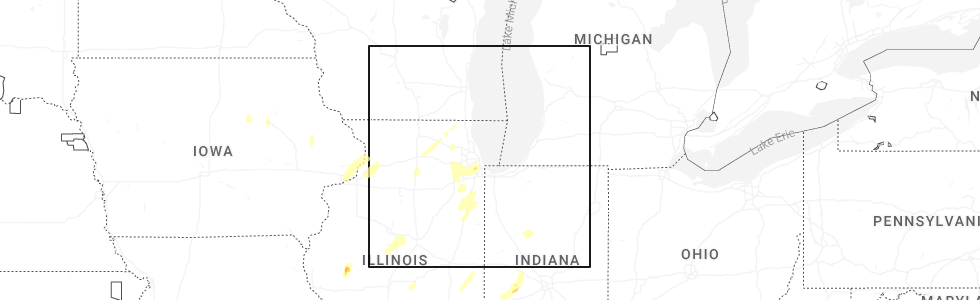
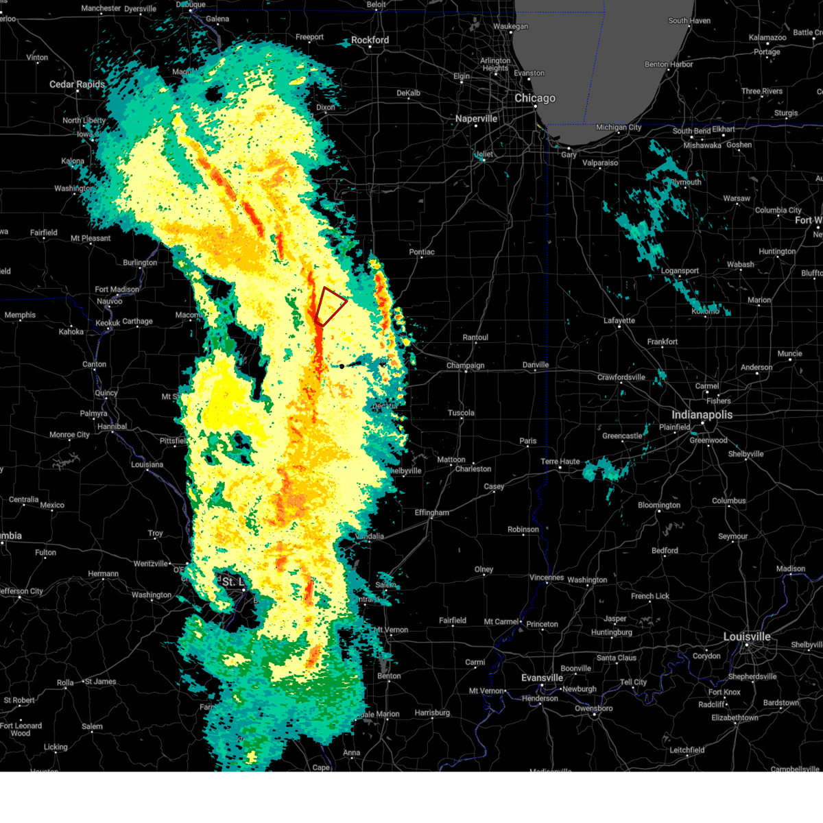
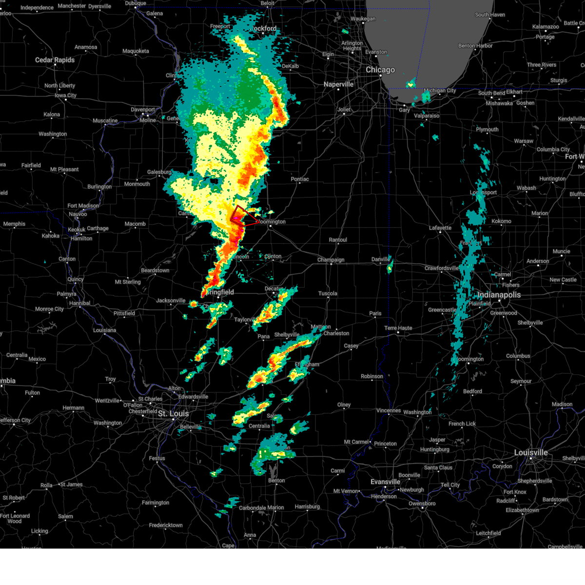
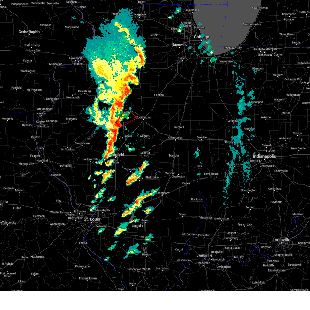
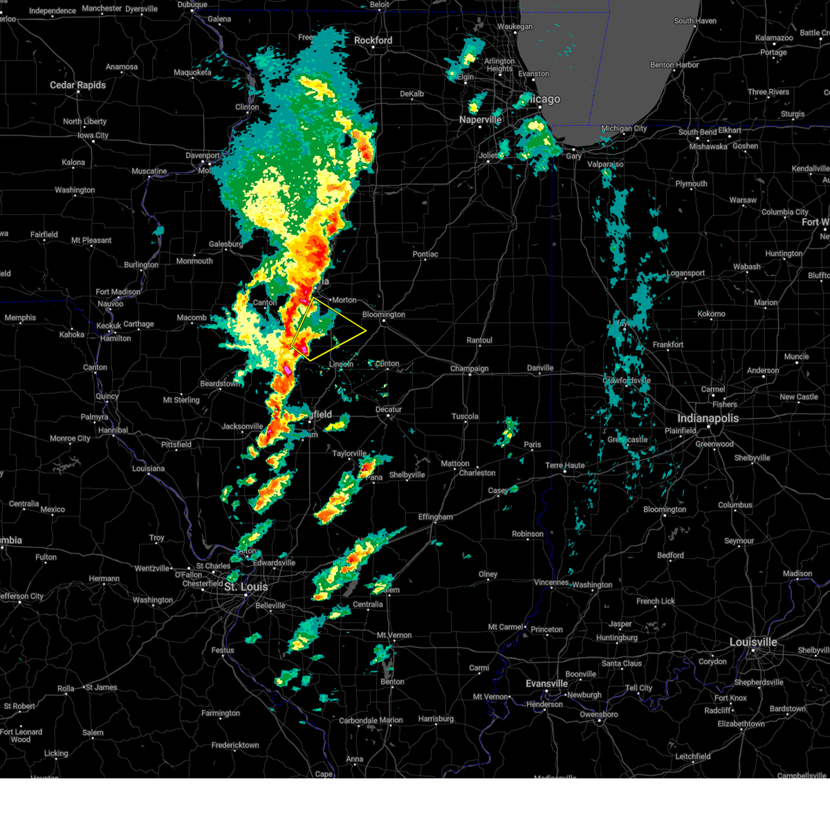
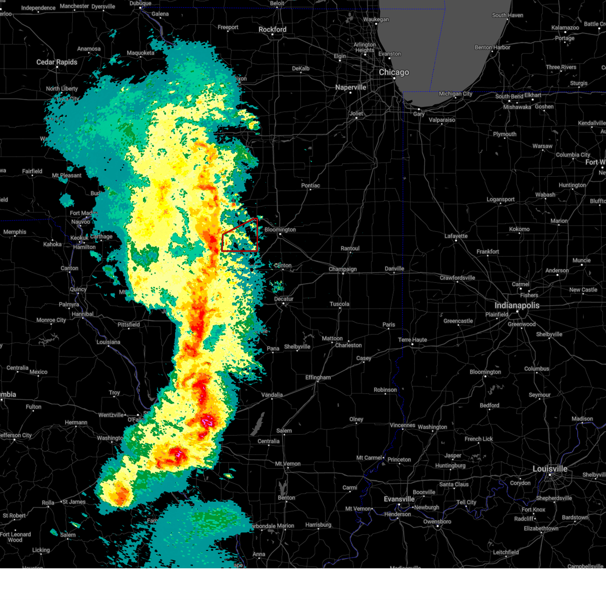
Hail Map for Tremont, IL
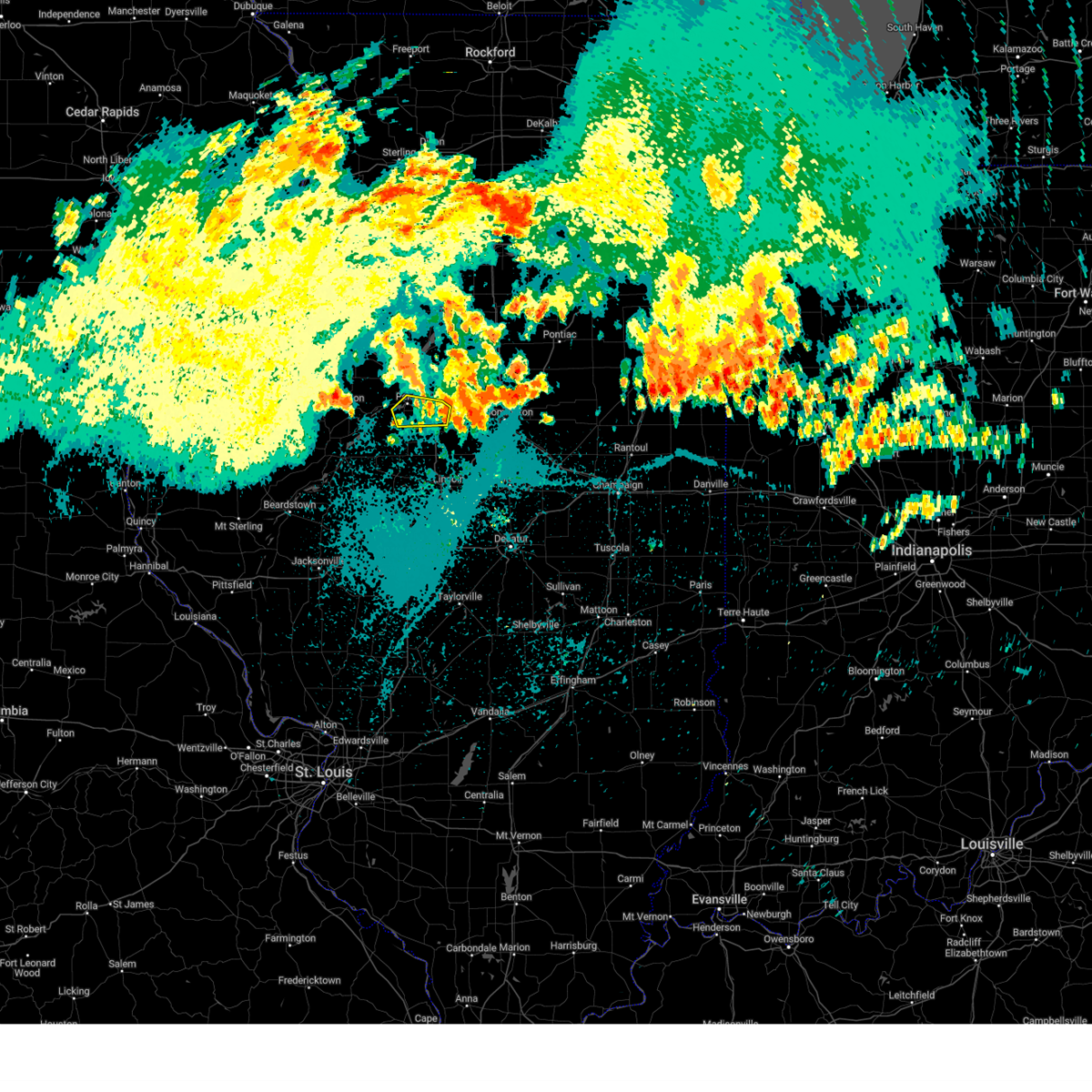
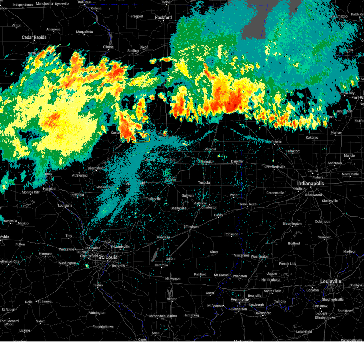
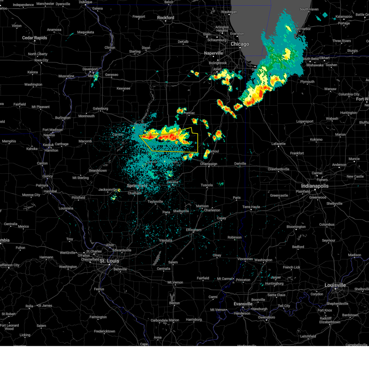
The Tremont, IL area has had 3 reports of on-the-ground hail by trained spotters, and has been under severe weather warnings 20 times during the past 12 months. Doppler radar has detected hail at or near Tremont, IL on 54 occasions, including 2 occasions during the past year.
| Name: | Tremont, IL |
| Where Located: | 12.6 miles SSE of Peoria, IL |
| Map: | Google Map for Tremont, IL |
| Population: | 2236 |
| Housing Units: | 942 |
| More Info: | Search Google for Tremont, IL |
1
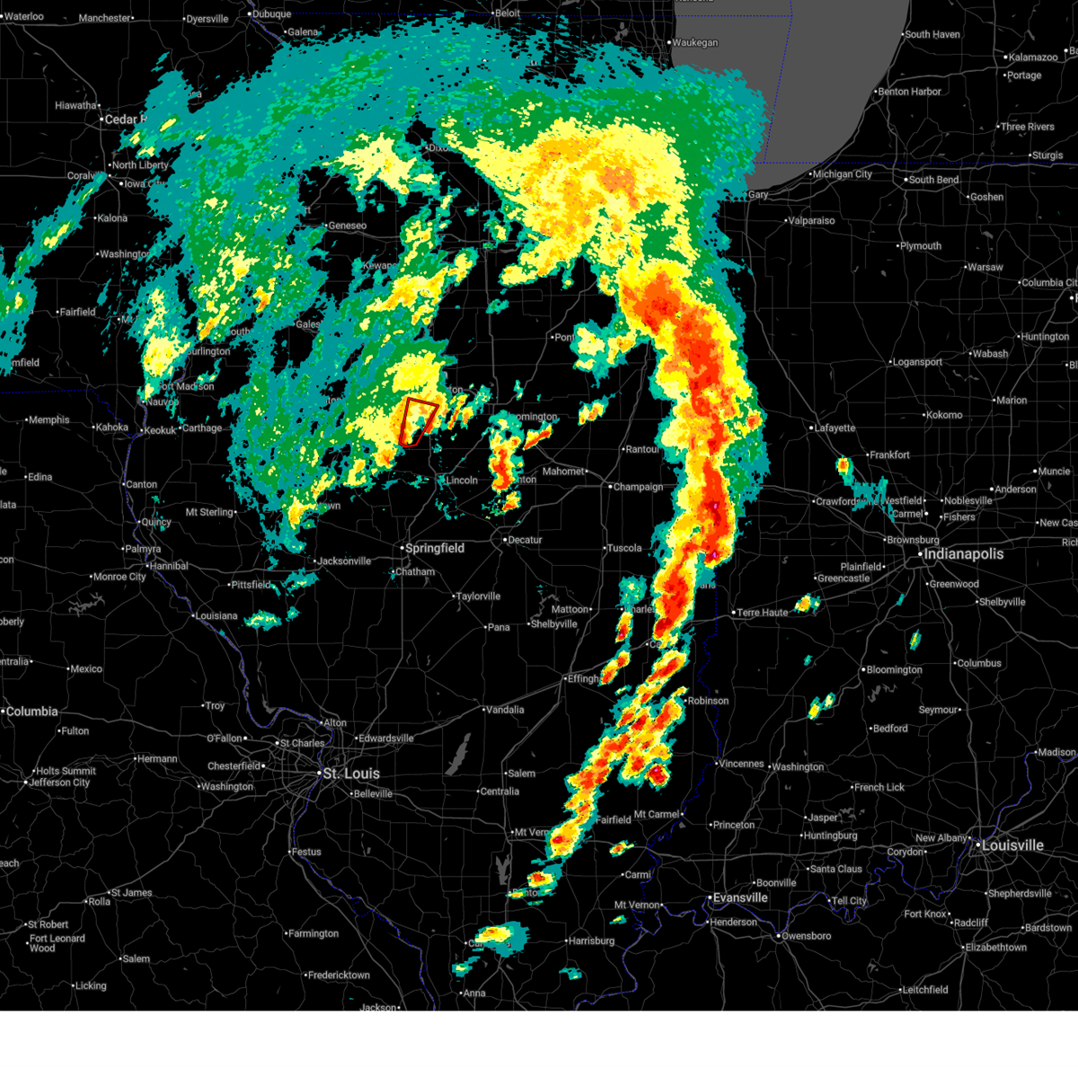
The Top Recent Hail Date for Tremont, IL is Wednesday, March 19, 2025 (7th out of 54)
Hail and Wind Damage Spotted near Tremont, IL
| Date / Time | Report Details |
|---|---|
| 6/18/2025 1:46 PM CDT | At 146 pm cdt, a severe thunderstorm capable of producing a tornado was located near delavan, or 13 miles south of pekin, moving northeast at 25 mph (radar indicated rotation). Hazards include tornado. Flying debris will be dangerous to those caught without shelter. mobile homes will be damaged or destroyed. damage to roofs, windows, and vehicles will occur. tree damage is likely. this dangerous storm will be near, tremont around 200 pm cdt. other locations impacted by this tornadic thunderstorm include dillon. This includes interstate 155 between mile markers 20 and 26. |
| 6/18/2025 1:37 PM CDT |
 Torilx the national weather service in lincoln has issued a * tornado warning for, southeastern tazewell county in central illinois, * until 200 pm cdt. * at 137 pm cdt, a severe thunderstorm capable of producing a tornado was located near san jose, or near mason city, moving north at 25 mph (radar indicated rotation). Hazards include tornado. Flying debris will be dangerous to those caught without shelter. mobile homes will be damaged or destroyed. damage to roofs, windows, and vehicles will occur. tree damage is likely. this dangerous storm will be near, delavan around 150 pm cdt. green valley around 155 pm cdt. This includes interstate 155 between mile markers 20 and 26. Torilx the national weather service in lincoln has issued a * tornado warning for, southeastern tazewell county in central illinois, * until 200 pm cdt. * at 137 pm cdt, a severe thunderstorm capable of producing a tornado was located near san jose, or near mason city, moving north at 25 mph (radar indicated rotation). Hazards include tornado. Flying debris will be dangerous to those caught without shelter. mobile homes will be damaged or destroyed. damage to roofs, windows, and vehicles will occur. tree damage is likely. this dangerous storm will be near, delavan around 150 pm cdt. green valley around 155 pm cdt. This includes interstate 155 between mile markers 20 and 26.
|
| 4/20/2025 9:11 PM CDT |
 the severe thunderstorm warning has been cancelled and is no longer in effect the severe thunderstorm warning has been cancelled and is no longer in effect
|
| 4/20/2025 8:59 PM CDT | The storms over logan county have weakened below severe limits, and no longer pose an immediate threat to life or property. a new severe thunderstorm warning has been issued for portions of tazewell and peoria counties. a tornado watch remains in effect until 1100 pm cdt for central illinois. remember, a severe thunderstorm warning still remains in effect for portions of tazewell and peoria counties until 9:30 pm!. |
| 4/20/2025 8:57 PM CDT | 6 inch diameter tree limbs down... and about a 70 foot section of a barn wall was blown ou in tazewell county IL, 5.3 miles WSW of Tremont, IL |
| 4/20/2025 8:56 PM CDT | Svrilx the national weather service in lincoln has issued a * severe thunderstorm warning for, marshall county in central illinois, woodford county in central illinois, stark county in north central illinois, tazewell county in central illinois, western mclean county in central illinois, northeastern peoria county in central illinois, * until 930 pm cdt. * at 855 pm cdt, severe thunderstorms were located along a line extending from near galva to washington to near armington, moving east at 50 mph (radar indicated). Hazards include 60 mph wind gusts. Expect damage to roofs, siding, and trees. severe thunderstorms will be near, peoria, rome, mackinaw, minier, spring bay, dunlap, chillicothe, armington, princeville, and germantown hills around 900 pm cdt. congerville, castleton, elmira, stanford, and danvers around 905 pm cdt. roanoke, camp grove, secor, osceola, and carlock around 910 pm cdt. bradford, sparland, washburn, el paso, lacon, normal, and bloomington around 915 pm cdt. other locations in the path of these severe thunderstorms include benson, downs, hudson and towanda. this includes the following highways, interstate 155 between mile markers 12 and 31. interstate 39 between mile markers 0 and 40. interstate 474 between mile markers 10 and 14. interstate 55 between mile markers 147 and 174. Interstate 74 between mile markers 89 and 145. |
| 4/20/2025 8:48 PM CDT |
 the severe thunderstorm warning has been cancelled and is no longer in effect the severe thunderstorm warning has been cancelled and is no longer in effect
|
| 4/20/2025 8:48 PM CDT |
 At 848 pm cdt, severe thunderstorms were located along a line extending from west peoria to near middletown, moving east at 50 mph (radar indicated). Hazards include 60 mph wind gusts and penny size hail. Expect damage to roofs, siding, and trees. these severe storms will be near, hartsburg, mackinaw, tremont, east peoria, morton, emden, hopedale, washington, and lincoln around 855 pm cdt. other locations impacted by these severe thunderstorms include north pekin, groveland, broadwell, and dillon. this includes the following highways, interstate 155 between mile markers 0 and 31. interstate 474 between mile markers 6 and 14. interstate 55 between mile markers 117 and 131. Interstate 74 between mile markers 94 and 108. At 848 pm cdt, severe thunderstorms were located along a line extending from west peoria to near middletown, moving east at 50 mph (radar indicated). Hazards include 60 mph wind gusts and penny size hail. Expect damage to roofs, siding, and trees. these severe storms will be near, hartsburg, mackinaw, tremont, east peoria, morton, emden, hopedale, washington, and lincoln around 855 pm cdt. other locations impacted by these severe thunderstorms include north pekin, groveland, broadwell, and dillon. this includes the following highways, interstate 155 between mile markers 0 and 31. interstate 474 between mile markers 6 and 14. interstate 55 between mile markers 117 and 131. Interstate 74 between mile markers 94 and 108.
|
| 4/20/2025 8:47 PM CDT |
 At 847 pm cdt, a severe thunderstorm capable of producing a tornado was located near tremont, or 9 miles southeast of pekin, moving northeast at 55 mph (radar indicated rotation). Hazards include tornado. Flying debris will be dangerous to those caught without shelter. mobile homes will be damaged or destroyed. damage to roofs, windows, and vehicles will occur. tree damage is likely. this dangerous storm will be near, tremont around 850 pm cdt. mackinaw and morton around 855 pm cdt. other locations impacted by this tornadic thunderstorm include dillon. this includes the following highways, interstate 155 between mile markers 20 and 31. Interstate 74 between mile markers 100 and 107. At 847 pm cdt, a severe thunderstorm capable of producing a tornado was located near tremont, or 9 miles southeast of pekin, moving northeast at 55 mph (radar indicated rotation). Hazards include tornado. Flying debris will be dangerous to those caught without shelter. mobile homes will be damaged or destroyed. damage to roofs, windows, and vehicles will occur. tree damage is likely. this dangerous storm will be near, tremont around 850 pm cdt. mackinaw and morton around 855 pm cdt. other locations impacted by this tornadic thunderstorm include dillon. this includes the following highways, interstate 155 between mile markers 20 and 31. Interstate 74 between mile markers 100 and 107.
|
| 4/20/2025 8:36 PM CDT | Torilx the national weather service in lincoln has issued a * tornado warning for, central tazewell county in central illinois, * until 900 pm cdt. * at 835 pm cdt, a severe thunderstorm capable of producing a tornado was located near san jose, or 9 miles north of mason city, moving northeast at 55 mph (radar indicated rotation). Hazards include tornado. Flying debris will be dangerous to those caught without shelter. mobile homes will be damaged or destroyed. damage to roofs, windows, and vehicles will occur. tree damage is likely. this dangerous storm will be near, delavan and green valley around 840 pm cdt. tremont around 845 pm cdt. morton around 855 pm cdt. this includes the following highways, interstate 155 between mile markers 20 and 31. Interstate 74 between mile markers 99 and 107. |
| 4/20/2025 8:34 PM CDT | the severe thunderstorm warning has been cancelled and is no longer in effect |
| 4/20/2025 8:34 PM CDT | At 833 pm cdt, severe thunderstorms were located along a line extending from near mapleton to near abraham lincoln capital airport, moving east at 55 mph (radar indicated). Hazards include 60 mph wind gusts. Expect damage to roofs, siding, and trees. these severe storms will be near, williamsville, peoria, middletown, san jose, delavan, new holland, marquette heights, tremont, creve coeur, and east peoria around 840 pm cdt. hartsburg, cornland, hopedale, washington, and lincoln around 845 pm cdt. mackinaw and deer creek around 850 pm cdt. other locations impacted by these severe thunderstorms include spaulding, north pekin, dillon, powerton, cantrall, groveland, fancy prairie, broadwell, kingston mines, and sweetwater. this includes the following highways, interstate 155 between mile markers 0 and 31. interstate 474 between mile markers 6 and 14. interstate 55 between mile markers 102 and 131. Interstate 74 between mile markers 93 and 108. |
| 4/20/2025 8:25 PM CDT | Svrilx the national weather service in lincoln has issued a * severe thunderstorm warning for, menard county in central illinois, logan county in central illinois, northwestern christian county in central illinois, sangamon county in central illinois, tazewell county in central illinois, eastern mason county in central illinois, southeastern peoria county in central illinois, * until 900 pm cdt. * at 825 pm cdt, severe thunderstorms were located along a line extending from glasford to near virden, moving northeast at 55 mph (radar indicated). Hazards include 60 mph wind gusts. Expect damage to roofs, siding, and trees. severe thunderstorms will be near, mason city, greenview, south pekin, mapleton, bartonville, chatham, peoria international airport, manito, green valley, and pekin around 830 pm cdt. west peoria, peoria, middletown, bellevue, san jose, new holland, marquette heights, creve coeur, east peoria, and sherman around 835 pm cdt. williamsville, delavan, rochester, and riverton around 840 pm cdt. tremont, morton, elkhart, emden, and washington around 845 pm cdt. other locations in the path of these severe thunderstorms include dawson, hartsburg, cornland, buffalo, hopedale, lincoln and mechanicsburg. this includes the following highways, interstate 155 between mile markers 0 and 31. interstate 474 between mile markers 6 and 14. interstate 55 between mile markers 77 and 131. interstate 72 between mile markers 86 and 119. Interstate 74 between mile markers 92 and 108. |
| 3/19/2025 3:46 PM CDT |
 At 346 pm cdt, a confirmed tornado was located over mackinaw, or 8 miles southeast of morton, moving northeast at 40 mph (weather spotters confirmed tornado). Hazards include damaging tornado. Flying debris will be dangerous to those caught without shelter. mobile homes will be damaged or destroyed. damage to roofs, windows, and vehicles will occur. tree damage is likely. this tornado will be near, mackinaw around 350 pm cdt. deer creek around 355 pm cdt. this includes the following highways, interstate 155 near mile marker 26. Interstate 74 between mile markers 104 and 109. At 346 pm cdt, a confirmed tornado was located over mackinaw, or 8 miles southeast of morton, moving northeast at 40 mph (weather spotters confirmed tornado). Hazards include damaging tornado. Flying debris will be dangerous to those caught without shelter. mobile homes will be damaged or destroyed. damage to roofs, windows, and vehicles will occur. tree damage is likely. this tornado will be near, mackinaw around 350 pm cdt. deer creek around 355 pm cdt. this includes the following highways, interstate 155 near mile marker 26. Interstate 74 between mile markers 104 and 109.
|
| 3/19/2025 3:28 PM CDT |
 Torilx the national weather service in lincoln has issued a * tornado warning for, eastern tazewell county in central illinois, west central mclean county in central illinois, * until 400 pm cdt. * at 327 pm cdt, a severe thunderstorm capable of producing a tornado was located over delavan, or 11 miles south of pekin, moving northeast at 35 mph (radar indicated rotation). Hazards include tornado. Flying debris will be dangerous to those caught without shelter. mobile homes will be damaged or destroyed. damage to roofs, windows, and vehicles will occur. tree damage is likely. this dangerous storm will be near, tremont around 335 pm cdt. mackinaw around 345 pm cdt. this includes the following highways, interstate 155 between mile markers 15 and 29. Interstate 74 between mile markers 103 and 109. Torilx the national weather service in lincoln has issued a * tornado warning for, eastern tazewell county in central illinois, west central mclean county in central illinois, * until 400 pm cdt. * at 327 pm cdt, a severe thunderstorm capable of producing a tornado was located over delavan, or 11 miles south of pekin, moving northeast at 35 mph (radar indicated rotation). Hazards include tornado. Flying debris will be dangerous to those caught without shelter. mobile homes will be damaged or destroyed. damage to roofs, windows, and vehicles will occur. tree damage is likely. this dangerous storm will be near, tremont around 335 pm cdt. mackinaw around 345 pm cdt. this includes the following highways, interstate 155 between mile markers 15 and 29. Interstate 74 between mile markers 103 and 109.
|
| 3/19/2025 3:19 PM CDT |
 Svrilx the national weather service in lincoln has issued a * severe thunderstorm warning for, northwestern logan county in central illinois, southeastern tazewell county in central illinois, western mclean county in central illinois, northeastern mason county in central illinois, * until 400 pm cdt. * at 318 pm cdt, a severe thunderstorm was located over san jose, or 8 miles north of mason city, moving northeast at 45 mph (radar indicated). Hazards include 70 mph wind gusts and quarter size hail. Hail damage to vehicles is expected. expect considerable tree damage. wind damage is also likely to mobile homes, roofs, and outbuildings. this severe thunderstorm will be near, delavan around 325 pm cdt. hopedale around 335 pm cdt. This includes interstate 155 between mile markers 9 and 28. Svrilx the national weather service in lincoln has issued a * severe thunderstorm warning for, northwestern logan county in central illinois, southeastern tazewell county in central illinois, western mclean county in central illinois, northeastern mason county in central illinois, * until 400 pm cdt. * at 318 pm cdt, a severe thunderstorm was located over san jose, or 8 miles north of mason city, moving northeast at 45 mph (radar indicated). Hazards include 70 mph wind gusts and quarter size hail. Hail damage to vehicles is expected. expect considerable tree damage. wind damage is also likely to mobile homes, roofs, and outbuildings. this severe thunderstorm will be near, delavan around 325 pm cdt. hopedale around 335 pm cdt. This includes interstate 155 between mile markers 9 and 28.
|
| 3/14/2025 10:11 PM CDT |
 Torilx the national weather service in lincoln has issued a * tornado warning for, southeastern tazewell county in central illinois, * until 1045 pm cdt. * at 1011 pm cdt, severe thunderstorms capable of producing both tornadoes and extensive straight line wind damage were located near green valley, or 10 miles south of pekin, moving northeast at 60 mph (radar indicated rotation). Hazards include tornado and quarter size hail. Flying debris will be dangerous to those caught without shelter. mobile homes will be damaged or destroyed. damage to roofs, windows, and vehicles will occur. tree damage is likely. these dangerous storms will be near, tremont around 1015 pm cdt. mackinaw and hopedale around 1020 pm cdt. This includes interstate 155 between mile markers 11 and 27. Torilx the national weather service in lincoln has issued a * tornado warning for, southeastern tazewell county in central illinois, * until 1045 pm cdt. * at 1011 pm cdt, severe thunderstorms capable of producing both tornadoes and extensive straight line wind damage were located near green valley, or 10 miles south of pekin, moving northeast at 60 mph (radar indicated rotation). Hazards include tornado and quarter size hail. Flying debris will be dangerous to those caught without shelter. mobile homes will be damaged or destroyed. damage to roofs, windows, and vehicles will occur. tree damage is likely. these dangerous storms will be near, tremont around 1015 pm cdt. mackinaw and hopedale around 1020 pm cdt. This includes interstate 155 between mile markers 11 and 27.
|
| 3/14/2025 10:04 PM CDT |
 Svrilx the national weather service in lincoln has issued a * severe thunderstorm warning for, eastern menard county in central illinois, logan county in central illinois, western christian county in central illinois, sangamon county in central illinois, tazewell county in central illinois, southwestern mclean county in central illinois, east central mason county in central illinois, * until 1100 pm cdt. * at 1004 pm cdt, severe thunderstorms were located along a line extending from near manito to near greenview to near waverly, moving northeast at 60 mph (radar indicated). Hazards include 70 mph wind gusts. Expect considerable tree damage. damage is likely to mobile homes, roofs, and outbuildings. severe thunderstorms will be near, mason city, middletown, san jose, delavan, new holland, chatham, green valley, pekin, sherman, and springfield around 1010 pm cdt. williamsville, hartsburg, tremont, morton, elkhart, emden, hopedale, and riverton around 1015 pm cdt. mackinaw, rochester, and lincoln around 1020 pm cdt. other locations in the path of these severe thunderstorms include dawson, minier, buffalo, cornland, armington, mechanicsburg, mount pulaski, atlanta, stanford, danvers, beason, mclean, illiopolis and carlock. this includes the following highways, interstate 155 between mile markers 0 and 31. interstate 55 between mile markers 77 and 145. interstate 72 between mile markers 87 and 122. Interstate 74 between mile markers 119 and 121. Svrilx the national weather service in lincoln has issued a * severe thunderstorm warning for, eastern menard county in central illinois, logan county in central illinois, western christian county in central illinois, sangamon county in central illinois, tazewell county in central illinois, southwestern mclean county in central illinois, east central mason county in central illinois, * until 1100 pm cdt. * at 1004 pm cdt, severe thunderstorms were located along a line extending from near manito to near greenview to near waverly, moving northeast at 60 mph (radar indicated). Hazards include 70 mph wind gusts. Expect considerable tree damage. damage is likely to mobile homes, roofs, and outbuildings. severe thunderstorms will be near, mason city, middletown, san jose, delavan, new holland, chatham, green valley, pekin, sherman, and springfield around 1010 pm cdt. williamsville, hartsburg, tremont, morton, elkhart, emden, hopedale, and riverton around 1015 pm cdt. mackinaw, rochester, and lincoln around 1020 pm cdt. other locations in the path of these severe thunderstorms include dawson, minier, buffalo, cornland, armington, mechanicsburg, mount pulaski, atlanta, stanford, danvers, beason, mclean, illiopolis and carlock. this includes the following highways, interstate 155 between mile markers 0 and 31. interstate 55 between mile markers 77 and 145. interstate 72 between mile markers 87 and 122. Interstate 74 between mile markers 119 and 121.
|
| 8/27/2024 11:22 PM CDT |
 The storm which prompted the warning has weakened below severe limits, and no longer poses an immediate threat to life or property. therefore, the warning has been allowed to expire. however, gusty winds and heavy rain are still possible with this thunderstorm. The storm which prompted the warning has weakened below severe limits, and no longer poses an immediate threat to life or property. therefore, the warning has been allowed to expire. however, gusty winds and heavy rain are still possible with this thunderstorm.
|
| 8/27/2024 10:40 PM CDT |
 Svrilx the national weather service in lincoln has issued a * severe thunderstorm warning for, central tazewell county in central illinois, southeastern peoria county in central illinois, * until 1115 pm cdt. * at 1039 pm cdt, a severe thunderstorm was located over tremont, or near morton, moving east at 25 mph (radar indicated). Hazards include 60 mph wind gusts and quarter size hail. Hail damage to vehicles is expected. expect wind damage to roofs, siding, and trees. this severe thunderstorm will be near, mackinaw around 1045 pm cdt. This includes interstate 155 between mile markers 21 and 29. Svrilx the national weather service in lincoln has issued a * severe thunderstorm warning for, central tazewell county in central illinois, southeastern peoria county in central illinois, * until 1115 pm cdt. * at 1039 pm cdt, a severe thunderstorm was located over tremont, or near morton, moving east at 25 mph (radar indicated). Hazards include 60 mph wind gusts and quarter size hail. Hail damage to vehicles is expected. expect wind damage to roofs, siding, and trees. this severe thunderstorm will be near, mackinaw around 1045 pm cdt. This includes interstate 155 between mile markers 21 and 29.
|
| 8/16/2024 9:29 PM CDT |
 Svrilx the national weather service in lincoln has issued a * severe thunderstorm warning for, southeastern tazewell county in central illinois, mclean county in central illinois, * until 1015 pm cdt. * at 928 pm cdt, severe thunderstorms were located along a line extending from tremont to near normal to near towanda, moving east at 35 mph (radar indicated). Hazards include 60 mph wind gusts and quarter size hail. Hail damage to vehicles is expected. expect wind damage to roofs, siding, and trees. severe thunderstorms will be near, bloomington, normal, mackinaw, and danvers around 935 pm cdt. minier, downs, and stanford around 940 pm cdt. other locations in the path of these severe thunderstorms include saybrook. this includes the following highways, interstate 155 between mile markers 21 and 29. interstate 39 between mile markers 0 and 6. interstate 55 between mile markers 148 and 180. Interstate 74 between mile markers 119 and 149. Svrilx the national weather service in lincoln has issued a * severe thunderstorm warning for, southeastern tazewell county in central illinois, mclean county in central illinois, * until 1015 pm cdt. * at 928 pm cdt, severe thunderstorms were located along a line extending from tremont to near normal to near towanda, moving east at 35 mph (radar indicated). Hazards include 60 mph wind gusts and quarter size hail. Hail damage to vehicles is expected. expect wind damage to roofs, siding, and trees. severe thunderstorms will be near, bloomington, normal, mackinaw, and danvers around 935 pm cdt. minier, downs, and stanford around 940 pm cdt. other locations in the path of these severe thunderstorms include saybrook. this includes the following highways, interstate 155 between mile markers 21 and 29. interstate 39 between mile markers 0 and 6. interstate 55 between mile markers 148 and 180. Interstate 74 between mile markers 119 and 149.
|
| 7/15/2024 9:03 PM CDT |
 At 902 pm cdt, severe thunderstorms were located along a line extending from near flanagan to near danvers to near san jose, moving southeast at 55 mph. these are destructive storms (trained weather spotters and law enforcement have reported wind gusts of 70-80+ mph). Hazards include 80 mph wind gusts and penny size hail. Flying debris will be dangerous to those caught without shelter. mobile homes will be heavily damaged. expect considerable damage to roofs, windows, and vehicles. extensive tree damage and power outages are likely. these severe storms will be near, bloomington, normal, lincoln, hudson, gridley, danvers, stanford, armington, and hartsburg around 910 pm cdt. atlanta, mclean, and towanda around 915 pm cdt. heyworth and waynesville around 920 pm cdt. other locations impacted by these severe thunderstorms include lawndale, north pekin, kappa, banner, dillon, powerton, panola, cazenovia, low point, and groveland. this includes the following highways, interstate 155 between mile markers 0 and 31. interstate 39 between mile markers 0 and 40. interstate 474 between mile markers 6 and 14. interstate 55 between mile markers 123 and 172. Interstate 74 between mile markers 91 and 139. At 902 pm cdt, severe thunderstorms were located along a line extending from near flanagan to near danvers to near san jose, moving southeast at 55 mph. these are destructive storms (trained weather spotters and law enforcement have reported wind gusts of 70-80+ mph). Hazards include 80 mph wind gusts and penny size hail. Flying debris will be dangerous to those caught without shelter. mobile homes will be heavily damaged. expect considerable damage to roofs, windows, and vehicles. extensive tree damage and power outages are likely. these severe storms will be near, bloomington, normal, lincoln, hudson, gridley, danvers, stanford, armington, and hartsburg around 910 pm cdt. atlanta, mclean, and towanda around 915 pm cdt. heyworth and waynesville around 920 pm cdt. other locations impacted by these severe thunderstorms include lawndale, north pekin, kappa, banner, dillon, powerton, panola, cazenovia, low point, and groveland. this includes the following highways, interstate 155 between mile markers 0 and 31. interstate 39 between mile markers 0 and 40. interstate 474 between mile markers 6 and 14. interstate 55 between mile markers 123 and 172. Interstate 74 between mile markers 91 and 139.
|
| 7/15/2024 9:03 PM CDT |
 the severe thunderstorm warning has been cancelled and is no longer in effect the severe thunderstorm warning has been cancelled and is no longer in effect
|
| 7/15/2024 8:51 PM CDT |
 At 850 pm cdt, severe thunderstorms were located along a line extending from near minonk to deer creek to near green valley, moving southeast at 60 mph (trained weather spotters reported 70 mph wind gusts near henry, illinois in marshall county). Hazards include 70 mph wind gusts and penny size hail. Expect considerable tree damage. damage is likely to mobile homes, roofs, and outbuildings. these severe storms will be near, el paso, minonk, mackinaw, delavan, minier, hopedale, goodfield, san jose, emden, and congerville around 855 pm cdt. hudson, gridley, danvers, stanford, carlock, armington, and hartsburg around 900 pm cdt. bloomington, normal, lincoln, atlanta, and mclean around 905 pm cdt. towanda and waynesville around 910 pm cdt. heyworth around 915 pm cdt. other locations impacted by these severe thunderstorms include lawndale, smithville, dillon, powerton, panola, norwood, kickapoo, la rose, peoria heights, and shirley. this includes the following highways, interstate 155 between mile markers 0 and 31. interstate 39 between mile markers 0 and 40. interstate 474 between mile markers 0 and 14. interstate 55 between mile markers 123 and 172. Interstate 74 between mile markers 77 and 139. At 850 pm cdt, severe thunderstorms were located along a line extending from near minonk to deer creek to near green valley, moving southeast at 60 mph (trained weather spotters reported 70 mph wind gusts near henry, illinois in marshall county). Hazards include 70 mph wind gusts and penny size hail. Expect considerable tree damage. damage is likely to mobile homes, roofs, and outbuildings. these severe storms will be near, el paso, minonk, mackinaw, delavan, minier, hopedale, goodfield, san jose, emden, and congerville around 855 pm cdt. hudson, gridley, danvers, stanford, carlock, armington, and hartsburg around 900 pm cdt. bloomington, normal, lincoln, atlanta, and mclean around 905 pm cdt. towanda and waynesville around 910 pm cdt. heyworth around 915 pm cdt. other locations impacted by these severe thunderstorms include lawndale, smithville, dillon, powerton, panola, norwood, kickapoo, la rose, peoria heights, and shirley. this includes the following highways, interstate 155 between mile markers 0 and 31. interstate 39 between mile markers 0 and 40. interstate 474 between mile markers 0 and 14. interstate 55 between mile markers 123 and 172. Interstate 74 between mile markers 77 and 139.
|
| 7/15/2024 8:27 PM CDT |
 Svrilx the national weather service in lincoln has issued a * severe thunderstorm warning for, marshall county in central illinois, northern logan county in central illinois, woodford county in central illinois, northeastern fulton county in west central illinois, stark county in north central illinois, southeastern knox county in west central illinois, northwestern de witt county in central illinois, tazewell county in central illinois, western mclean county in central illinois, northeastern mason county in central illinois, peoria county in central illinois, * until 930 pm cdt. * at 827 pm cdt, severe thunderstorms were located along a line extending from near camp grove to near dunlap to near canton, moving southeast at 55 mph (radar indicated). Hazards include 70 mph wind gusts and penny size hail. Expect considerable tree damage. damage is likely to mobile homes, roofs, and outbuildings. severe thunderstorms will be near, peoria, chillicothe, bartonville, west peoria, bellevue, rome, hanna city, glasford, spring bay, and sparland around 830 pm cdt. pekin, east peoria, lacon, washington, creve coeur, germantown hills, marquette heights, manito, and mapleton around 835 pm cdt. morton, metamora, and south pekin around 840 pm cdt. tremont, washburn, green valley, and deer creek around 845 pm cdt. other locations in the path of these severe thunderstorms include eureka, mackinaw, delavan, goodfield, san jose, roanoke, hopedale, emden, congerville, minier, danvers, stanford, carlock, benson, secor, hartsburg, el paso and armington. this includes the following highways, interstate 155 between mile markers 0 and 31. interstate 39 between mile markers 0 and 40. interstate 474 between mile markers 0 and 14. interstate 55 between mile markers 123 and 172. Interstate 74 between mile markers 64 and 139. Svrilx the national weather service in lincoln has issued a * severe thunderstorm warning for, marshall county in central illinois, northern logan county in central illinois, woodford county in central illinois, northeastern fulton county in west central illinois, stark county in north central illinois, southeastern knox county in west central illinois, northwestern de witt county in central illinois, tazewell county in central illinois, western mclean county in central illinois, northeastern mason county in central illinois, peoria county in central illinois, * until 930 pm cdt. * at 827 pm cdt, severe thunderstorms were located along a line extending from near camp grove to near dunlap to near canton, moving southeast at 55 mph (radar indicated). Hazards include 70 mph wind gusts and penny size hail. Expect considerable tree damage. damage is likely to mobile homes, roofs, and outbuildings. severe thunderstorms will be near, peoria, chillicothe, bartonville, west peoria, bellevue, rome, hanna city, glasford, spring bay, and sparland around 830 pm cdt. pekin, east peoria, lacon, washington, creve coeur, germantown hills, marquette heights, manito, and mapleton around 835 pm cdt. morton, metamora, and south pekin around 840 pm cdt. tremont, washburn, green valley, and deer creek around 845 pm cdt. other locations in the path of these severe thunderstorms include eureka, mackinaw, delavan, goodfield, san jose, roanoke, hopedale, emden, congerville, minier, danvers, stanford, carlock, benson, secor, hartsburg, el paso and armington. this includes the following highways, interstate 155 between mile markers 0 and 31. interstate 39 between mile markers 0 and 40. interstate 474 between mile markers 0 and 14. interstate 55 between mile markers 123 and 172. Interstate 74 between mile markers 64 and 139.
|
| 7/15/2024 1:45 AM CDT |
 The storms which prompted the warning have weakened below severe limits, and no longer pose an immediate threat to life or property. therefore, the warning has been allowed to expire. however, gusty winds and heavy rain are still possible with these thunderstorms. a severe thunderstorm watch remains in effect until 300 am cdt for central illinois. a severe thunderstorm watch also remains in effect until 400 am cdt for central illinois. The storms which prompted the warning have weakened below severe limits, and no longer pose an immediate threat to life or property. therefore, the warning has been allowed to expire. however, gusty winds and heavy rain are still possible with these thunderstorms. a severe thunderstorm watch remains in effect until 300 am cdt for central illinois. a severe thunderstorm watch also remains in effect until 400 am cdt for central illinois.
|
| 7/15/2024 1:22 AM CDT |
 the severe thunderstorm warning has been cancelled and is no longer in effect the severe thunderstorm warning has been cancelled and is no longer in effect
|
| 7/15/2024 1:22 AM CDT |
 At 121 am cdt, severe thunderstorms were located along a line extending from near bloomington to mclean, moving southeast at 50 mph (radar indicated). Hazards include 60 mph wind gusts and quarter size hail. Hail damage to vehicles is expected. expect wind damage to roofs, siding, and trees. these severe storms will be near, mclean around 125 am cdt. other locations impacted by these severe thunderstorms include shirley, central illinois regional airport, and dillon. this includes the following highways, interstate 155 between mile markers 8 and 31. interstate 39 between mile markers 0 and 6. interstate 55 between mile markers 141 and 169. Interstate 74 between mile markers 102 and 109, and between mile markers 119 and 138. At 121 am cdt, severe thunderstorms were located along a line extending from near bloomington to mclean, moving southeast at 50 mph (radar indicated). Hazards include 60 mph wind gusts and quarter size hail. Hail damage to vehicles is expected. expect wind damage to roofs, siding, and trees. these severe storms will be near, mclean around 125 am cdt. other locations impacted by these severe thunderstorms include shirley, central illinois regional airport, and dillon. this includes the following highways, interstate 155 between mile markers 8 and 31. interstate 39 between mile markers 0 and 6. interstate 55 between mile markers 141 and 169. Interstate 74 between mile markers 102 and 109, and between mile markers 119 and 138.
|
| 7/15/2024 12:53 AM CDT |
 Svrilx the national weather service in lincoln has issued a * severe thunderstorm warning for, northeastern logan county in central illinois, south central woodford county in central illinois, eastern tazewell county in central illinois, southwestern mclean county in central illinois, * until 145 am cdt. * at 1252 am cdt, severe thunderstorms were located along a line extending from near eureka to near tremont, moving southeast at 50 mph (radar indicated). Hazards include 60 mph wind gusts and quarter size hail. Hail damage to vehicles is expected. expect wind damage to roofs, siding, and trees. severe thunderstorms will be near, mackinaw, danvers, hopedale, goodfield, carlock, and congerville around 100 am cdt. minier and stanford around 105 am cdt. bloomington, normal, and armington around 110 am cdt. other locations in the path of these severe thunderstorms include mclean and atlanta. this includes the following highways, interstate 155 between mile markers 8 and 31. interstate 39 between mile markers 0 and 5. interstate 55 between mile markers 141 and 169. Interstate 74 between mile markers 102 and 138. Svrilx the national weather service in lincoln has issued a * severe thunderstorm warning for, northeastern logan county in central illinois, south central woodford county in central illinois, eastern tazewell county in central illinois, southwestern mclean county in central illinois, * until 145 am cdt. * at 1252 am cdt, severe thunderstorms were located along a line extending from near eureka to near tremont, moving southeast at 50 mph (radar indicated). Hazards include 60 mph wind gusts and quarter size hail. Hail damage to vehicles is expected. expect wind damage to roofs, siding, and trees. severe thunderstorms will be near, mackinaw, danvers, hopedale, goodfield, carlock, and congerville around 100 am cdt. minier and stanford around 105 am cdt. bloomington, normal, and armington around 110 am cdt. other locations in the path of these severe thunderstorms include mclean and atlanta. this includes the following highways, interstate 155 between mile markers 8 and 31. interstate 39 between mile markers 0 and 5. interstate 55 between mile markers 141 and 169. Interstate 74 between mile markers 102 and 138.
|
| 6/25/2024 9:53 PM CDT |
 The storm which prompted the warning has weakened below severe limits, and no longer poses an immediate threat to life or property. therefore, the warning will be allowed to expire. however, gusty winds and heavy rain are still possible with this thunderstorm. a severe thunderstorm watch remains in effect until midnight cdt for central and west central illinois. The storm which prompted the warning has weakened below severe limits, and no longer poses an immediate threat to life or property. therefore, the warning will be allowed to expire. however, gusty winds and heavy rain are still possible with this thunderstorm. a severe thunderstorm watch remains in effect until midnight cdt for central and west central illinois.
|
| 6/25/2024 9:15 PM CDT |
 Svrilx the national weather service in lincoln has issued a * severe thunderstorm warning for, northern logan county in central illinois, central fulton county in west central illinois, tazewell county in central illinois, northeastern mason county in central illinois, south central peoria county in central illinois, * until 1000 pm cdt. * at 915 pm cdt, a severe thunderstorm was located near tremont, or 9 miles southeast of pekin, moving southeast at 35 mph (radar indicated). Hazards include 60 mph wind gusts and quarter size hail. Hail damage to vehicles is expected. expect wind damage to roofs, siding, and trees. this severe thunderstorm will be near, delavan and hopedale around 920 pm cdt. emden around 930 pm cdt. hartsburg around 935 pm cdt. this includes the following highways, interstate 155 between mile markers 5 and 29. Interstate 55 between mile markers 136 and 138. Svrilx the national weather service in lincoln has issued a * severe thunderstorm warning for, northern logan county in central illinois, central fulton county in west central illinois, tazewell county in central illinois, northeastern mason county in central illinois, south central peoria county in central illinois, * until 1000 pm cdt. * at 915 pm cdt, a severe thunderstorm was located near tremont, or 9 miles southeast of pekin, moving southeast at 35 mph (radar indicated). Hazards include 60 mph wind gusts and quarter size hail. Hail damage to vehicles is expected. expect wind damage to roofs, siding, and trees. this severe thunderstorm will be near, delavan and hopedale around 920 pm cdt. emden around 930 pm cdt. hartsburg around 935 pm cdt. this includes the following highways, interstate 155 between mile markers 5 and 29. Interstate 55 between mile markers 136 and 138.
|
| 6/25/2024 8:53 PM CDT |
 At 852 pm cdt, a severe thunderstorm was located over bartonville, or near pekin, moving south at 35 mph (radar indicated). Hazards include 70 mph wind gusts and quarter size hail. Hail damage to vehicles is expected. expect considerable tree damage. wind damage is also likely to mobile homes, roofs, and outbuildings. this severe storm will be near, pekin and south pekin around 900 pm cdt. other locations impacted by this severe thunderstorm include smithville, dillon, powerton, west jersey, dunfermline, norwood, kickapoo, fiatt, dahinda, and peoria heights. this includes the following highways, interstate 155 between mile markers 19 and 31. interstate 474 between mile markers 0 and 14. Interstate 74 between mile markers 58 and 106. At 852 pm cdt, a severe thunderstorm was located over bartonville, or near pekin, moving south at 35 mph (radar indicated). Hazards include 70 mph wind gusts and quarter size hail. Hail damage to vehicles is expected. expect considerable tree damage. wind damage is also likely to mobile homes, roofs, and outbuildings. this severe storm will be near, pekin and south pekin around 900 pm cdt. other locations impacted by this severe thunderstorm include smithville, dillon, powerton, west jersey, dunfermline, norwood, kickapoo, fiatt, dahinda, and peoria heights. this includes the following highways, interstate 155 between mile markers 19 and 31. interstate 474 between mile markers 0 and 14. Interstate 74 between mile markers 58 and 106.
|
| 6/25/2024 8:53 PM CDT |
 the severe thunderstorm warning has been cancelled and is no longer in effect the severe thunderstorm warning has been cancelled and is no longer in effect
|
| 6/25/2024 8:41 PM CDT |
 At 840 pm cdt, a severe thunderstorm was located over bellevue, or near peoria, moving south at 30 mph (radar indicated). Hazards include 70 mph wind gusts and quarter size hail. Hail damage to vehicles is expected. expect considerable tree damage. wind damage is also likely to mobile homes, roofs, and outbuildings. this severe storm will be near, peoria, bartonville, west peoria, bellevue, and peoria international airport around 845 pm cdt. pekin around 850 pm cdt. mapleton around 855 pm cdt. south pekin around 905 pm cdt. other locations impacted by this severe thunderstorm include smithville, dillon, powerton, west jersey, dunfermline, norwood, kickapoo, fiatt, dahinda, and peoria heights. this includes the following highways, interstate 155 between mile markers 19 and 31. interstate 474 between mile markers 0 and 14. Interstate 74 between mile markers 58 and 117. At 840 pm cdt, a severe thunderstorm was located over bellevue, or near peoria, moving south at 30 mph (radar indicated). Hazards include 70 mph wind gusts and quarter size hail. Hail damage to vehicles is expected. expect considerable tree damage. wind damage is also likely to mobile homes, roofs, and outbuildings. this severe storm will be near, peoria, bartonville, west peoria, bellevue, and peoria international airport around 845 pm cdt. pekin around 850 pm cdt. mapleton around 855 pm cdt. south pekin around 905 pm cdt. other locations impacted by this severe thunderstorm include smithville, dillon, powerton, west jersey, dunfermline, norwood, kickapoo, fiatt, dahinda, and peoria heights. this includes the following highways, interstate 155 between mile markers 19 and 31. interstate 474 between mile markers 0 and 14. Interstate 74 between mile markers 58 and 117.
|
| 6/25/2024 8:20 PM CDT |
 Svrilx the national weather service in lincoln has issued a * severe thunderstorm warning for, southwestern marshall county in central illinois, western woodford county in central illinois, northeastern fulton county in west central illinois, southern stark county in north central illinois, southeastern knox county in west central illinois, tazewell county in central illinois, west central mclean county in central illinois, peoria county in central illinois, * until 915 pm cdt. * at 820 pm cdt, severe thunderstorms were located along a line extending from near benson to 6 miles east of knoxville, moving south at 20 mph (radar indicated). Hazards include 70 mph wind gusts and half dollar size hail. Hail damage to vehicles is expected. expect considerable tree damage. wind damage is also likely to mobile homes, roofs, and outbuildings. severe thunderstorms will be near, peoria, metamora, germantown hills, elmwood, roanoke, dunlap, brimfield, yates city, spring bay, and maquon around 825 pm cdt. east peoria, eureka, and washington around 830 pm cdt. west peoria, farmington, bellevue, hanna city, and trivoli around 835 pm cdt. morton, bartonville, creve coeur, goodfield, deer creek, congerville, and peoria international airport around 840 pm cdt. other locations in the path of these severe thunderstorms include marquette heights, pekin, canton, glasford, mapleton, tremont, mackinaw, danvers, south pekin and st. david. this includes the following highways, interstate 155 between mile markers 19 and 31. interstate 474 between mile markers 0 and 14. Interstate 74 between mile markers 58 and 117. Svrilx the national weather service in lincoln has issued a * severe thunderstorm warning for, southwestern marshall county in central illinois, western woodford county in central illinois, northeastern fulton county in west central illinois, southern stark county in north central illinois, southeastern knox county in west central illinois, tazewell county in central illinois, west central mclean county in central illinois, peoria county in central illinois, * until 915 pm cdt. * at 820 pm cdt, severe thunderstorms were located along a line extending from near benson to 6 miles east of knoxville, moving south at 20 mph (radar indicated). Hazards include 70 mph wind gusts and half dollar size hail. Hail damage to vehicles is expected. expect considerable tree damage. wind damage is also likely to mobile homes, roofs, and outbuildings. severe thunderstorms will be near, peoria, metamora, germantown hills, elmwood, roanoke, dunlap, brimfield, yates city, spring bay, and maquon around 825 pm cdt. east peoria, eureka, and washington around 830 pm cdt. west peoria, farmington, bellevue, hanna city, and trivoli around 835 pm cdt. morton, bartonville, creve coeur, goodfield, deer creek, congerville, and peoria international airport around 840 pm cdt. other locations in the path of these severe thunderstorms include marquette heights, pekin, canton, glasford, mapleton, tremont, mackinaw, danvers, south pekin and st. david. this includes the following highways, interstate 155 between mile markers 19 and 31. interstate 474 between mile markers 0 and 14. Interstate 74 between mile markers 58 and 117.
|
| 6/13/2024 7:42 PM CDT |
 Svrilx the national weather service in lincoln has issued a * severe thunderstorm warning for, southeastern woodford county in central illinois, northeastern tazewell county in central illinois, west central mclean county in central illinois, * until 830 pm cdt. * at 741 pm cdt, a severe thunderstorm was located over morton, moving east at 35 mph (radar indicated). Hazards include 60 mph wind gusts and quarter size hail. Hail damage to vehicles is expected. expect wind damage to roofs, siding, and trees. this severe thunderstorm will be near, deer creek around 745 pm cdt. goodfield around 750 pm cdt. congerville around 755 pm cdt. other locations in the path of this severe thunderstorm include carlock. this includes the following highways, interstate 155 between mile markers 23 and 31. interstate 474 between mile markers 11 and 14. interstate 55 between mile markers 159 and 163. Interstate 74 between mile markers 95 and 131. Svrilx the national weather service in lincoln has issued a * severe thunderstorm warning for, southeastern woodford county in central illinois, northeastern tazewell county in central illinois, west central mclean county in central illinois, * until 830 pm cdt. * at 741 pm cdt, a severe thunderstorm was located over morton, moving east at 35 mph (radar indicated). Hazards include 60 mph wind gusts and quarter size hail. Hail damage to vehicles is expected. expect wind damage to roofs, siding, and trees. this severe thunderstorm will be near, deer creek around 745 pm cdt. goodfield around 750 pm cdt. congerville around 755 pm cdt. other locations in the path of this severe thunderstorm include carlock. this includes the following highways, interstate 155 between mile markers 23 and 31. interstate 474 between mile markers 11 and 14. interstate 55 between mile markers 159 and 163. Interstate 74 between mile markers 95 and 131.
|
| 5/7/2024 6:17 AM CDT | A measured 62 mph wind gust was reported by a trained spotter at route 9 and hoffman in mackina in tazewell county IL, 5.8 miles W of Tremont, IL |
| 5/7/2024 6:11 AM CDT | Corrects the time for the previous tstm wnd gst report from 1 sw mackinaw. a measured 62 mph wind gust was reported by a trained spotter at route 9 and hoffman in macki in tazewell county IL, 5.8 miles W of Tremont, IL |
| 5/7/2024 6:06 AM CDT |
 At 606 am cdt, a severe thunderstorm was located near mackinaw, or 7 miles south of morton, moving northeast at 45 mph (radar indicated). Hazards include 60 mph wind gusts and penny size hail. Expect damage to roofs, siding, and trees. this severe storm will be near, mackinaw around 610 am cdt. deer creek around 615 am cdt. this includes the following highways, interstate 155 between mile markers 26 and 31. Interstate 74 between mile markers 101 and 109. At 606 am cdt, a severe thunderstorm was located near mackinaw, or 7 miles south of morton, moving northeast at 45 mph (radar indicated). Hazards include 60 mph wind gusts and penny size hail. Expect damage to roofs, siding, and trees. this severe storm will be near, mackinaw around 610 am cdt. deer creek around 615 am cdt. this includes the following highways, interstate 155 between mile markers 26 and 31. Interstate 74 between mile markers 101 and 109.
|
| 5/7/2024 5:58 AM CDT |
 At 557 am cdt, a severe thunderstorm was located near tremont, or 8 miles southeast of pekin, moving northeast at 40 mph (radar indicated). Hazards include 60 mph wind gusts and penny size hail. Expect damage to roofs, siding, and trees. this severe storm will be near, tremont and mackinaw around 605 am cdt. deer creek around 615 am cdt. other locations impacted by this severe thunderstorm include dillon and groveland. this includes the following highways, interstate 155 between mile markers 15 and 31. Interstate 74 between mile markers 101 and 109. At 557 am cdt, a severe thunderstorm was located near tremont, or 8 miles southeast of pekin, moving northeast at 40 mph (radar indicated). Hazards include 60 mph wind gusts and penny size hail. Expect damage to roofs, siding, and trees. this severe storm will be near, tremont and mackinaw around 605 am cdt. deer creek around 615 am cdt. other locations impacted by this severe thunderstorm include dillon and groveland. this includes the following highways, interstate 155 between mile markers 15 and 31. Interstate 74 between mile markers 101 and 109.
|
| 5/7/2024 5:44 AM CDT |
 Svrilx the national weather service in lincoln has issued a * severe thunderstorm warning for, eastern tazewell county in central illinois, * until 630 am cdt. * at 544 am cdt, a severe thunderstorm was located over green valley, or 12 miles south of pekin, moving northeast at 45 mph (radar indicated). Hazards include 60 mph wind gusts and penny size hail. Expect damage to roofs, siding, and trees. this severe thunderstorm will be near, south pekin and green valley around 550 am cdt. tremont around 555 am cdt. other locations in the path of this severe thunderstorm include morton, mackinaw and deer creek. this includes the following highways, interstate 155 between mile markers 15 and 31. Interstate 74 between mile markers 101 and 109. Svrilx the national weather service in lincoln has issued a * severe thunderstorm warning for, eastern tazewell county in central illinois, * until 630 am cdt. * at 544 am cdt, a severe thunderstorm was located over green valley, or 12 miles south of pekin, moving northeast at 45 mph (radar indicated). Hazards include 60 mph wind gusts and penny size hail. Expect damage to roofs, siding, and trees. this severe thunderstorm will be near, south pekin and green valley around 550 am cdt. tremont around 555 am cdt. other locations in the path of this severe thunderstorm include morton, mackinaw and deer creek. this includes the following highways, interstate 155 between mile markers 15 and 31. Interstate 74 between mile markers 101 and 109.
|
| 3/14/2024 5:43 AM CDT |
 The storm which prompted the warning has weakened below severe limits, and no longer appears capable of producing a tornado. therefore, the warning will be allowed to expire. however, small hail and gusty winds are still possible with this thunderstorm. a severe thunderstorm watch remains in effect until 1000 am cdt for central illinois. The storm which prompted the warning has weakened below severe limits, and no longer appears capable of producing a tornado. therefore, the warning will be allowed to expire. however, small hail and gusty winds are still possible with this thunderstorm. a severe thunderstorm watch remains in effect until 1000 am cdt for central illinois.
|
| 3/14/2024 5:42 AM CDT |
 The storm which prompted the warning has moved out of the area. therefore, the warning will be allowed to expire. however, gusty winds are still possible with this thunderstorm. a severe thunderstorm watch remains in effect until 1000 am cdt for central illinois. The storm which prompted the warning has moved out of the area. therefore, the warning will be allowed to expire. however, gusty winds are still possible with this thunderstorm. a severe thunderstorm watch remains in effect until 1000 am cdt for central illinois.
|
| 3/14/2024 5:30 AM CDT |
 Torilx the national weather service in lincoln has issued a * tornado warning for, central tazewell county in central illinois, * until 545 am cdt. * at 529 am cdt, a severe thunderstorm capable of producing a tornado was located near south pekin, or 9 miles southwest of pekin, moving northeast at 40 mph (radar indicated rotation). Hazards include tornado and quarter size hail. Flying debris will be dangerous to those caught without shelter. mobile homes will be damaged or destroyed. damage to roofs, windows, and vehicles will occur. tree damage is likely. this dangerous storm will be near, pekin and south pekin around 535 am cdt. this includes the following highways, interstate 155 between mile markers 23 and 27. Interstate 474 near mile marker 11. Torilx the national weather service in lincoln has issued a * tornado warning for, central tazewell county in central illinois, * until 545 am cdt. * at 529 am cdt, a severe thunderstorm capable of producing a tornado was located near south pekin, or 9 miles southwest of pekin, moving northeast at 40 mph (radar indicated rotation). Hazards include tornado and quarter size hail. Flying debris will be dangerous to those caught without shelter. mobile homes will be damaged or destroyed. damage to roofs, windows, and vehicles will occur. tree damage is likely. this dangerous storm will be near, pekin and south pekin around 535 am cdt. this includes the following highways, interstate 155 between mile markers 23 and 27. Interstate 474 near mile marker 11.
|
| 3/14/2024 5:22 AM CDT |
 Svrilx the national weather service in lincoln has issued a * severe thunderstorm warning for, northwestern logan county in central illinois, southwestern tazewell county in central illinois, northeastern mason county in central illinois, * until 545 am cdt. * at 522 am cdt, a severe thunderstorm was located near manito, or 11 miles northwest of mason city, moving east at 45 mph (radar indicated). Hazards include 60 mph wind gusts and quarter size hail. Hail damage to vehicles is expected. expect wind damage to roofs, siding, and trees. this severe thunderstorm will be near, manito around 525 am cdt. green valley around 530 am cdt. delavan around 535 am cdt. This includes interstate 155 between mile markers 8 and 25. Svrilx the national weather service in lincoln has issued a * severe thunderstorm warning for, northwestern logan county in central illinois, southwestern tazewell county in central illinois, northeastern mason county in central illinois, * until 545 am cdt. * at 522 am cdt, a severe thunderstorm was located near manito, or 11 miles northwest of mason city, moving east at 45 mph (radar indicated). Hazards include 60 mph wind gusts and quarter size hail. Hail damage to vehicles is expected. expect wind damage to roofs, siding, and trees. this severe thunderstorm will be near, manito around 525 am cdt. green valley around 530 am cdt. delavan around 535 am cdt. This includes interstate 155 between mile markers 8 and 25.
|
| 9/26/2023 11:28 PM CDT |
 The severe thunderstorm warning for eastern tazewell county will expire at 1130 pm cdt, the storm which prompted the warning has weakened below severe limits, and no longer poses an immediate threat to life or property. therefore, the warning will be allowed to expire. however, small hail, gusty winds and heavy rain are still possible with this thunderstorm. The severe thunderstorm warning for eastern tazewell county will expire at 1130 pm cdt, the storm which prompted the warning has weakened below severe limits, and no longer poses an immediate threat to life or property. therefore, the warning will be allowed to expire. however, small hail, gusty winds and heavy rain are still possible with this thunderstorm.
|
| 9/26/2023 11:07 PM CDT |
 At 1106 pm cdt, a severe thunderstorm was located over tremont, or 9 miles east of pekin, moving northeast at 25 mph (radar indicated). Hazards include 60 mph wind gusts and quarter size hail. Hail damage to vehicles is expected. expect wind damage to roofs, siding, and trees. this severe storm will be near, morton and mackinaw around 1110 pm cdt. deer creek around 1120 pm cdt. other locations impacted by this severe thunderstorm include dillon. hail threat, radar indicated max hail size, 1. 00 in wind threat, radar indicated max wind gust, 60 mph. At 1106 pm cdt, a severe thunderstorm was located over tremont, or 9 miles east of pekin, moving northeast at 25 mph (radar indicated). Hazards include 60 mph wind gusts and quarter size hail. Hail damage to vehicles is expected. expect wind damage to roofs, siding, and trees. this severe storm will be near, morton and mackinaw around 1110 pm cdt. deer creek around 1120 pm cdt. other locations impacted by this severe thunderstorm include dillon. hail threat, radar indicated max hail size, 1. 00 in wind threat, radar indicated max wind gust, 60 mph.
|
| 9/26/2023 10:49 PM CDT |
 At 1049 pm cdt, a severe thunderstorm was located near green valley, or 8 miles south of pekin, moving northeast at 25 mph (radar indicated). Hazards include 60 mph wind gusts and quarter size hail. Hail damage to vehicles is expected. expect wind damage to roofs, siding, and trees. this severe thunderstorm will be near, tremont around 1055 pm cdt. morton around 1105 pm cdt. other locations in the path of this severe thunderstorm include mackinaw and deer creek. this includes the following highways, interstate 155 between mile markers 17 and 31. interstate 74 between mile markers 102 and 109. hail threat, radar indicated max hail size, 1. 00 in wind threat, radar indicated max wind gust, 60 mph. At 1049 pm cdt, a severe thunderstorm was located near green valley, or 8 miles south of pekin, moving northeast at 25 mph (radar indicated). Hazards include 60 mph wind gusts and quarter size hail. Hail damage to vehicles is expected. expect wind damage to roofs, siding, and trees. this severe thunderstorm will be near, tremont around 1055 pm cdt. morton around 1105 pm cdt. other locations in the path of this severe thunderstorm include mackinaw and deer creek. this includes the following highways, interstate 155 between mile markers 17 and 31. interstate 74 between mile markers 102 and 109. hail threat, radar indicated max hail size, 1. 00 in wind threat, radar indicated max wind gust, 60 mph.
|
| 8/11/2023 7:59 AM CDT |
 At 758 am cdt, a severe thunderstorm was located over hopedale, or 15 miles southeast of pekin, moving southeast at 45 mph (radar indicated). Hazards include 60 mph wind gusts. Expect damage to roofs, siding, and trees. locations impacted include, stanford, armington, atlanta and mclean. this includes the following highways, interstate 155 between mile markers 8 and 31. interstate 55 between mile markers 132 and 159. interstate 74 between mile markers 102 and 109, and between mile markers 131 and 136. hail threat, radar indicated max hail size, <. 75 in wind threat, observed max wind gust, 60 mph. At 758 am cdt, a severe thunderstorm was located over hopedale, or 15 miles southeast of pekin, moving southeast at 45 mph (radar indicated). Hazards include 60 mph wind gusts. Expect damage to roofs, siding, and trees. locations impacted include, stanford, armington, atlanta and mclean. this includes the following highways, interstate 155 between mile markers 8 and 31. interstate 55 between mile markers 132 and 159. interstate 74 between mile markers 102 and 109, and between mile markers 131 and 136. hail threat, radar indicated max hail size, <. 75 in wind threat, observed max wind gust, 60 mph.
|
| 8/11/2023 7:57 AM CDT |
 The severe thunderstorm warning for western tazewell and southern peoria counties will expire at 800 am cdt, the storm which prompted the warning has moved out of the area. therefore, the warning will be allowed to expire. to report severe weather, contact your nearest law enforcement agency. they will relay your report to the national weather service lincoln. a severe thunderstorm warning remains in effect for the remainder of tazewell county until 830 am. The severe thunderstorm warning for western tazewell and southern peoria counties will expire at 800 am cdt, the storm which prompted the warning has moved out of the area. therefore, the warning will be allowed to expire. to report severe weather, contact your nearest law enforcement agency. they will relay your report to the national weather service lincoln. a severe thunderstorm warning remains in effect for the remainder of tazewell county until 830 am.
|
| 8/11/2023 7:44 AM CDT |
 At 744 am cdt, a severe thunderstorm was located near pekin, moving southeast at 45 mph (radar indicated). Hazards include 70 mph wind gusts. Expect considerable tree damage. damage is likely to mobile homes, roofs, and outbuildings. this severe thunderstorm will be near, mackinaw and hopedale around 755 am cdt. minier around 800 am cdt. other locations in the path of this severe thunderstorm include stanford, armington, atlanta and mclean. this includes the following highways, interstate 155 between mile markers 8 and 31. interstate 474 between mile markers 10 and 14. interstate 55 between mile markers 132 and 159. interstate 74 between mile markers 96 and 109, and between mile markers 131 and 136. thunderstorm damage threat, considerable hail threat, radar indicated max hail size, <. 75 in wind threat, observed max wind gust, 70 mph. At 744 am cdt, a severe thunderstorm was located near pekin, moving southeast at 45 mph (radar indicated). Hazards include 70 mph wind gusts. Expect considerable tree damage. damage is likely to mobile homes, roofs, and outbuildings. this severe thunderstorm will be near, mackinaw and hopedale around 755 am cdt. minier around 800 am cdt. other locations in the path of this severe thunderstorm include stanford, armington, atlanta and mclean. this includes the following highways, interstate 155 between mile markers 8 and 31. interstate 474 between mile markers 10 and 14. interstate 55 between mile markers 132 and 159. interstate 74 between mile markers 96 and 109, and between mile markers 131 and 136. thunderstorm damage threat, considerable hail threat, radar indicated max hail size, <. 75 in wind threat, observed max wind gust, 70 mph.
|
| 8/11/2023 7:41 AM CDT |
 At 740 am cdt, a severe thunderstorm was located over pekin, moving southeast at 45 mph (emergency management. at 735 am, peoria county emergency management reported a measured wind gust of 63 mph at bellevue). Hazards include 60 mph wind gusts and penny size hail. Expect damage to roofs, siding, and trees. locations impacted include, tremont. this includes the following highways, interstate 155 between mile markers 25 and 31. interstate 474 between mile markers 0 and 14. interstate 74 between mile markers 83 and 108. hail threat, radar indicated max hail size, 0. 75 in wind threat, observed max wind gust, 60 mph. At 740 am cdt, a severe thunderstorm was located over pekin, moving southeast at 45 mph (emergency management. at 735 am, peoria county emergency management reported a measured wind gust of 63 mph at bellevue). Hazards include 60 mph wind gusts and penny size hail. Expect damage to roofs, siding, and trees. locations impacted include, tremont. this includes the following highways, interstate 155 between mile markers 25 and 31. interstate 474 between mile markers 0 and 14. interstate 74 between mile markers 83 and 108. hail threat, radar indicated max hail size, 0. 75 in wind threat, observed max wind gust, 60 mph.
|
| 8/11/2023 7:29 AM CDT |
 At 728 am cdt, a severe thunderstorm was located over hanna city, or 8 miles southwest of peoria, moving southeast at 45 mph (emergency management. at 724 am, fulton county emergency management reported 60 mph winds as the storms passed farmington). Hazards include 60 mph wind gusts and penny size hail. Expect damage to roofs, siding, and trees. this severe storm will be near, bartonville around 735 am cdt. pekin, creve coeur and marquette heights around 740 am cdt. other locations in the path of this severe thunderstorm include morton, south pekin and tremont. this includes the following highways, interstate 155 between mile markers 25 and 31. interstate 474 between mile markers 0 and 14. interstate 74 between mile markers 75 and 108. hail threat, radar indicated max hail size, 0. 75 in wind threat, observed max wind gust, 60 mph. At 728 am cdt, a severe thunderstorm was located over hanna city, or 8 miles southwest of peoria, moving southeast at 45 mph (emergency management. at 724 am, fulton county emergency management reported 60 mph winds as the storms passed farmington). Hazards include 60 mph wind gusts and penny size hail. Expect damage to roofs, siding, and trees. this severe storm will be near, bartonville around 735 am cdt. pekin, creve coeur and marquette heights around 740 am cdt. other locations in the path of this severe thunderstorm include morton, south pekin and tremont. this includes the following highways, interstate 155 between mile markers 25 and 31. interstate 474 between mile markers 0 and 14. interstate 74 between mile markers 75 and 108. hail threat, radar indicated max hail size, 0. 75 in wind threat, observed max wind gust, 60 mph.
|
| 8/11/2023 7:21 AM CDT |
 At 719 am cdt, a severe thunderstorm was located near elmwood, or 13 miles west of peoria, moving southeast at 45 mph (radar indicated). Hazards include 60 mph wind gusts and penny size hail. Expect damage to roofs, siding, and trees. this severe thunderstorm will be near, hanna city around 725 am cdt. peoria around 730 am cdt. bartonville, west peoria and bellevue around 735 am cdt. other locations in the path of this severe thunderstorm include pekin, creve coeur, marquette heights, morton, south pekin and tremont. this includes the following highways, interstate 155 between mile markers 25 and 31. interstate 474 between mile markers 0 and 14. interstate 74 between mile markers 69 and 108. hail threat, radar indicated max hail size, 0. 75 in wind threat, radar indicated max wind gust, 60 mph. At 719 am cdt, a severe thunderstorm was located near elmwood, or 13 miles west of peoria, moving southeast at 45 mph (radar indicated). Hazards include 60 mph wind gusts and penny size hail. Expect damage to roofs, siding, and trees. this severe thunderstorm will be near, hanna city around 725 am cdt. peoria around 730 am cdt. bartonville, west peoria and bellevue around 735 am cdt. other locations in the path of this severe thunderstorm include pekin, creve coeur, marquette heights, morton, south pekin and tremont. this includes the following highways, interstate 155 between mile markers 25 and 31. interstate 474 between mile markers 0 and 14. interstate 74 between mile markers 69 and 108. hail threat, radar indicated max hail size, 0. 75 in wind threat, radar indicated max wind gust, 60 mph.
|
| 6/29/2023 11:46 AM CDT |
 At 1145 am cdt, severe thunderstorms were located along a line extending from near maquon to near canton to 6 miles southeast of st. david, moving east at 65 mph (radar indicated). Hazards include 70 mph wind gusts and half dollar size hail. Hail damage to vehicles is expected. expect considerable tree damage. wind damage is also likely to mobile homes, roofs, and outbuildings. severe thunderstorms will be near, glasford and trivoli around 1150 am cdt. manito and brimfield around 1155 am cdt. bartonville, hanna city and south pekin around 1200 pm cdt. peoria, pekin, morton, creve coeur, marquette heights, bellevue, dunlap and green valley around 1205 pm cdt. other locations in the path of these severe thunderstorms include west peoria, tremont, delavan, east peoria, washington, germantown hills, mackinaw, hopedale, deer creek, spring bay, bay view gardens, metamora, minier, goodfield, armington and eureka. this includes the following highways, interstate 155 between mile markers 12 and 31. interstate 474 between mile markers 0 and 14. Interstate 74 between mile markers 70 and 112. At 1145 am cdt, severe thunderstorms were located along a line extending from near maquon to near canton to 6 miles southeast of st. david, moving east at 65 mph (radar indicated). Hazards include 70 mph wind gusts and half dollar size hail. Hail damage to vehicles is expected. expect considerable tree damage. wind damage is also likely to mobile homes, roofs, and outbuildings. severe thunderstorms will be near, glasford and trivoli around 1150 am cdt. manito and brimfield around 1155 am cdt. bartonville, hanna city and south pekin around 1200 pm cdt. peoria, pekin, morton, creve coeur, marquette heights, bellevue, dunlap and green valley around 1205 pm cdt. other locations in the path of these severe thunderstorms include west peoria, tremont, delavan, east peoria, washington, germantown hills, mackinaw, hopedale, deer creek, spring bay, bay view gardens, metamora, minier, goodfield, armington and eureka. this includes the following highways, interstate 155 between mile markers 12 and 31. interstate 474 between mile markers 0 and 14. Interstate 74 between mile markers 70 and 112.
|
| 6/29/2023 4:03 AM CDT |
 At 403 am cdt, a severe thunderstorm was located over morton, or 10 miles east of pekin, moving east at 25 mph (radar indicated). Hazards include half dollar size hail. Damage to vehicles is expected. locations impacted include, mackinaw, deer creek and goodfield. this includes the following highways, interstate 155 between mile markers 24 and 31. interstate 474 near mile marker 14. interstate 74 between mile markers 99 and 109. hail threat, radar indicated max hail size, 1. 25 in wind threat, radar indicated max wind gust, <50 mph. At 403 am cdt, a severe thunderstorm was located over morton, or 10 miles east of pekin, moving east at 25 mph (radar indicated). Hazards include half dollar size hail. Damage to vehicles is expected. locations impacted include, mackinaw, deer creek and goodfield. this includes the following highways, interstate 155 between mile markers 24 and 31. interstate 474 near mile marker 14. interstate 74 between mile markers 99 and 109. hail threat, radar indicated max hail size, 1. 25 in wind threat, radar indicated max wind gust, <50 mph.
|
| 6/29/2023 3:44 AM CDT |
 At 343 am cdt, a severe thunderstorm was located over pekin, moving east at 25 mph (radar indicated). Hazards include half dollar size hail. Damage to vehicles is expected. this severe thunderstorm will be near, morton and tremont around 355 am cdt. other locations in the path of this severe thunderstorm include mackinaw, deer creek and goodfield. this includes the following highways, interstate 155 between mile markers 25 and 31. interstate 474 between mile markers 10 and 14. interstate 74 between mile markers 97 and 109. hail threat, radar indicated max hail size, 1. 25 in wind threat, radar indicated max wind gust, <50 mph. At 343 am cdt, a severe thunderstorm was located over pekin, moving east at 25 mph (radar indicated). Hazards include half dollar size hail. Damage to vehicles is expected. this severe thunderstorm will be near, morton and tremont around 355 am cdt. other locations in the path of this severe thunderstorm include mackinaw, deer creek and goodfield. this includes the following highways, interstate 155 between mile markers 25 and 31. interstate 474 between mile markers 10 and 14. interstate 74 between mile markers 97 and 109. hail threat, radar indicated max hail size, 1. 25 in wind threat, radar indicated max wind gust, <50 mph.
|
| 5/7/2023 8:52 PM CDT |
 At 852 pm cdt, a severe thunderstorm was located over mackinaw, or 10 miles southwest of eureka, moving east at 55 mph (radar indicated). Hazards include 60 mph wind gusts and quarter size hail. Hail damage to vehicles is expected. expect wind damage to roofs, siding, and trees. this severe thunderstorm will be near, goodfield around 855 pm cdt. minier around 900 pm cdt. danvers, stanford and carlock around 905 pm cdt. other locations in the path of this severe thunderstorm include bloomington, normal and towanda. this includes the following highways, interstate 155 between mile markers 16 and 31. interstate 39 between mile markers 0 and 28. interstate 55 between mile markers 145 and 186. interstate 74 between mile markers 99 and 138. hail threat, radar indicated max hail size, 1. 00 in wind threat, radar indicated max wind gust, 60 mph. At 852 pm cdt, a severe thunderstorm was located over mackinaw, or 10 miles southwest of eureka, moving east at 55 mph (radar indicated). Hazards include 60 mph wind gusts and quarter size hail. Hail damage to vehicles is expected. expect wind damage to roofs, siding, and trees. this severe thunderstorm will be near, goodfield around 855 pm cdt. minier around 900 pm cdt. danvers, stanford and carlock around 905 pm cdt. other locations in the path of this severe thunderstorm include bloomington, normal and towanda. this includes the following highways, interstate 155 between mile markers 16 and 31. interstate 39 between mile markers 0 and 28. interstate 55 between mile markers 145 and 186. interstate 74 between mile markers 99 and 138. hail threat, radar indicated max hail size, 1. 00 in wind threat, radar indicated max wind gust, 60 mph.
|
| 5/7/2023 12:00 AM CDT |
 At 1159 pm cdt, severe thunderstorms were located along a line extending from near morton to san jose to easton, moving east at 50 mph (radar indicated. at 1153 pm, emergency management reported dime size airport near the south pekin airport). Hazards include 60 mph wind gusts and quarter size hail. Hail damage to vehicles is expected. expect wind damage to roofs, siding, and trees. these severe storms will be near, morton, tremont and delavan around 1205 am cdt. mackinaw and emden around 1210 am cdt. other locations in the path of these severe thunderstorms include goodfield, hartsburg and armington. this includes the following highways, interstate 155 between mile markers 1 and 31. interstate 74 between mile markers 101 and 106. hail threat, radar indicated max hail size, 1. 00 in wind threat, radar indicated max wind gust, 60 mph. At 1159 pm cdt, severe thunderstorms were located along a line extending from near morton to san jose to easton, moving east at 50 mph (radar indicated. at 1153 pm, emergency management reported dime size airport near the south pekin airport). Hazards include 60 mph wind gusts and quarter size hail. Hail damage to vehicles is expected. expect wind damage to roofs, siding, and trees. these severe storms will be near, morton, tremont and delavan around 1205 am cdt. mackinaw and emden around 1210 am cdt. other locations in the path of these severe thunderstorms include goodfield, hartsburg and armington. this includes the following highways, interstate 155 between mile markers 1 and 31. interstate 74 between mile markers 101 and 106. hail threat, radar indicated max hail size, 1. 00 in wind threat, radar indicated max wind gust, 60 mph.
|
| 5/6/2023 11:51 PM CDT |
 At 1150 pm cdt, severe thunderstorms were located along a line extending from pekin to near san jose to near easton, moving east at 50 mph (radar indicated). Hazards include 60 mph wind gusts and penny size hail. Expect damage to roofs, siding, and trees. severe thunderstorms will be near, pekin, morton, marquette heights and green valley around 1155 pm cdt. tremont, delavan and san jose around 1200 am cdt. mackinaw, hopedale and emden around 1205 am cdt. minier, goodfield and hartsburg around 1210 am cdt. other locations in the path of these severe thunderstorms include armington. this includes the following highways, interstate 155 between mile markers 1 and 31. interstate 74 between mile markers 101 and 106. hail threat, radar indicated max hail size, 0. 75 in wind threat, radar indicated max wind gust, 60 mph. At 1150 pm cdt, severe thunderstorms were located along a line extending from pekin to near san jose to near easton, moving east at 50 mph (radar indicated). Hazards include 60 mph wind gusts and penny size hail. Expect damage to roofs, siding, and trees. severe thunderstorms will be near, pekin, morton, marquette heights and green valley around 1155 pm cdt. tremont, delavan and san jose around 1200 am cdt. mackinaw, hopedale and emden around 1205 am cdt. minier, goodfield and hartsburg around 1210 am cdt. other locations in the path of these severe thunderstorms include armington. this includes the following highways, interstate 155 between mile markers 1 and 31. interstate 74 between mile markers 101 and 106. hail threat, radar indicated max hail size, 0. 75 in wind threat, radar indicated max wind gust, 60 mph.
|
| 5/6/2023 11:48 PM CDT |
 At 1147 pm cdt, severe thunderstorms were located along a line extending from near pekin to 6 miles north of easton to near kilbourne, moving east at 40 mph (radar indicated). Hazards include 60 mph wind gusts and penny size hail. Expect damage to roofs, siding, and trees. these severe storms will be near, pekin, marquette heights and south pekin around 1155 pm cdt. tremont around 1200 am cdt. other locations impacted by these severe thunderstorms include topeka, north pekin, dillon, poplar city, mapleton, powerton, groveland, forest city, kingston mines and goofy ridge. This includes interstate 155 between mile markers 25 and 31. At 1147 pm cdt, severe thunderstorms were located along a line extending from near pekin to 6 miles north of easton to near kilbourne, moving east at 40 mph (radar indicated). Hazards include 60 mph wind gusts and penny size hail. Expect damage to roofs, siding, and trees. these severe storms will be near, pekin, marquette heights and south pekin around 1155 pm cdt. tremont around 1200 am cdt. other locations impacted by these severe thunderstorms include topeka, north pekin, dillon, poplar city, mapleton, powerton, groveland, forest city, kingston mines and goofy ridge. This includes interstate 155 between mile markers 25 and 31.
|
| 5/6/2023 11:40 PM CDT |
 At 1139 pm cdt, severe thunderstorms were located along a line extending from glasford to 7 miles west of manito to near bath, moving east at 40 mph (radar indicated). Hazards include 60 mph wind gusts and nickel size hail. Expect damage to roofs, siding, and trees. these severe storms will be near, glasford around 1145 pm cdt. manito around 1150 pm cdt. pekin, marquette heights and south pekin around 1155 pm cdt. green valley around 1200 am cdt. tremont around 1205 am cdt. other locations impacted by these severe thunderstorms include bryant, topeka, liverpool, north pekin, banner, chatauqua park, dillon, mapleton, powerton and dunfermline. This includes interstate 155 between mile markers 25 and 31. At 1139 pm cdt, severe thunderstorms were located along a line extending from glasford to 7 miles west of manito to near bath, moving east at 40 mph (radar indicated). Hazards include 60 mph wind gusts and nickel size hail. Expect damage to roofs, siding, and trees. these severe storms will be near, glasford around 1145 pm cdt. manito around 1150 pm cdt. pekin, marquette heights and south pekin around 1155 pm cdt. green valley around 1200 am cdt. tremont around 1205 am cdt. other locations impacted by these severe thunderstorms include bryant, topeka, liverpool, north pekin, banner, chatauqua park, dillon, mapleton, powerton and dunfermline. This includes interstate 155 between mile markers 25 and 31.
|
| 5/6/2023 11:26 PM CDT |
 At 1125 pm cdt, severe thunderstorms were located along a line extending from near glasford to near astoria, moving east at 35 mph (radar indicated). Hazards include 60 mph wind gusts and nickel size hail. Expect damage to roofs, siding, and trees. severe thunderstorms will be near, glasford around 1130 pm cdt. manito around 1135 pm cdt. havana and south pekin around 1145 pm cdt. other locations in the path of these severe thunderstorms include pekin, green valley and tremont. This includes interstate 155 between mile markers 25 and 31. At 1125 pm cdt, severe thunderstorms were located along a line extending from near glasford to near astoria, moving east at 35 mph (radar indicated). Hazards include 60 mph wind gusts and nickel size hail. Expect damage to roofs, siding, and trees. severe thunderstorms will be near, glasford around 1130 pm cdt. manito around 1135 pm cdt. havana and south pekin around 1145 pm cdt. other locations in the path of these severe thunderstorms include pekin, green valley and tremont. This includes interstate 155 between mile markers 25 and 31.
|
| 4/20/2023 4:58 PM CDT |
 At 458 pm cdt, severe thunderstorms were located along a line extending from bay view gardens to near glasford, moving northeast at 45 mph (trained weather spotters). Hazards include golf ball size hail and 60 mph wind gusts. People and animals outdoors will be injured. expect hail damage to roofs, siding, windows, and vehicles. expect wind damage to roofs, siding, and trees. these severe storms will be near, metamora, germantown hills, spring bay and bay view gardens around 505 pm cdt. bartonville, marquette heights, bellevue and washburn around 515 pm cdt. other locations in the path of these severe thunderstorms include creve coeur, west peoria, east peoria, morton, washington, toluca, deer creek, eureka, roanoke, secor and minonk. this includes the following highways, interstate 155 between mile markers 25 and 31. interstate 39 between mile markers 13 and 35. interstate 474 between mile markers 1 and 14. interstate 74 between mile markers 87 and 117. thunderstorm damage threat, considerable hail threat, observed max hail size, 1. 75 in wind threat, radar indicated max wind gust, 60 mph. At 458 pm cdt, severe thunderstorms were located along a line extending from bay view gardens to near glasford, moving northeast at 45 mph (trained weather spotters). Hazards include golf ball size hail and 60 mph wind gusts. People and animals outdoors will be injured. expect hail damage to roofs, siding, windows, and vehicles. expect wind damage to roofs, siding, and trees. these severe storms will be near, metamora, germantown hills, spring bay and bay view gardens around 505 pm cdt. bartonville, marquette heights, bellevue and washburn around 515 pm cdt. other locations in the path of these severe thunderstorms include creve coeur, west peoria, east peoria, morton, washington, toluca, deer creek, eureka, roanoke, secor and minonk. this includes the following highways, interstate 155 between mile markers 25 and 31. interstate 39 between mile markers 13 and 35. interstate 474 between mile markers 1 and 14. interstate 74 between mile markers 87 and 117. thunderstorm damage threat, considerable hail threat, observed max hail size, 1. 75 in wind threat, radar indicated max wind gust, 60 mph.
|
| 4/20/2023 4:55 PM CDT |
 At 455 pm cdt, severe thunderstorms were located along a line extending from bay view gardens to near glasford, moving northeast at 45 mph (trained weather spotters). Hazards include golf ball size hail and 60 mph wind gusts. People and animals outdoors will be injured. expect hail damage to roofs, siding, windows, and vehicles. expect wind damage to roofs, siding, and trees. severe thunderstorms will be near, germantown hills, spring bay and bay view gardens around 500 pm cdt. metamora around 505 pm cdt. pekin, bartonville, creve coeur, west peoria, marquette heights, tremont, bellevue and washburn around 515 pm cdt. other locations in the path of these severe thunderstorms include east peoria, morton, washington, toluca, deer creek, eureka, roanoke and secor. this includes the following highways, interstate 155 between mile markers 25 and 31. interstate 39 between mile markers 13 and 35. interstate 474 between mile markers 0 and 14. interstate 74 between mile markers 87 and 117. thunderstorm damage threat, considerable hail threat, observed max hail size, 1. 75 in wind threat, radar indicated max wind gust, 60 mph. At 455 pm cdt, severe thunderstorms were located along a line extending from bay view gardens to near glasford, moving northeast at 45 mph (trained weather spotters). Hazards include golf ball size hail and 60 mph wind gusts. People and animals outdoors will be injured. expect hail damage to roofs, siding, windows, and vehicles. expect wind damage to roofs, siding, and trees. severe thunderstorms will be near, germantown hills, spring bay and bay view gardens around 500 pm cdt. metamora around 505 pm cdt. pekin, bartonville, creve coeur, west peoria, marquette heights, tremont, bellevue and washburn around 515 pm cdt. other locations in the path of these severe thunderstorms include east peoria, morton, washington, toluca, deer creek, eureka, roanoke and secor. this includes the following highways, interstate 155 between mile markers 25 and 31. interstate 39 between mile markers 13 and 35. interstate 474 between mile markers 0 and 14. interstate 74 between mile markers 87 and 117. thunderstorm damage threat, considerable hail threat, observed max hail size, 1. 75 in wind threat, radar indicated max wind gust, 60 mph.
|
| 4/20/2023 4:40 PM CDT |
 At 440 pm cdt, severe thunderstorms were located along a line extending from near glasford to near st. david, moving northeast at 55 mph (trained weather spotters). Hazards include 60 mph wind gusts and quarter size hail. Hail damage to vehicles is expected. expect wind damage to roofs, siding, and trees. these severe storms will be near, hanna city around 445 pm cdt. other locations in the path of these severe thunderstorms include bartonville, manito, peoria, west peoria, bellevue, glasford, washington, germantown hills, spring bay, bay view gardens, pekin, creve coeur, marquette heights, east peoria and morton. this includes the following highways, interstate 155 between mile markers 25 and 31. interstate 474 between mile markers 0 and 14. interstate 74 between mile markers 85 and 110. hail threat, observed max hail size, 1. 00 in wind threat, radar indicated max wind gust, 60 mph. At 440 pm cdt, severe thunderstorms were located along a line extending from near glasford to near st. david, moving northeast at 55 mph (trained weather spotters). Hazards include 60 mph wind gusts and quarter size hail. Hail damage to vehicles is expected. expect wind damage to roofs, siding, and trees. these severe storms will be near, hanna city around 445 pm cdt. other locations in the path of these severe thunderstorms include bartonville, manito, peoria, west peoria, bellevue, glasford, washington, germantown hills, spring bay, bay view gardens, pekin, creve coeur, marquette heights, east peoria and morton. this includes the following highways, interstate 155 between mile markers 25 and 31. interstate 474 between mile markers 0 and 14. interstate 74 between mile markers 85 and 110. hail threat, observed max hail size, 1. 00 in wind threat, radar indicated max wind gust, 60 mph.
|
| 4/20/2023 4:28 PM CDT |
 At 428 pm cdt, severe thunderstorms were located along a line extending from near canton to lewistown, moving northeast at 55 mph (emergency management). Hazards include 60 mph wind gusts and quarter size hail. Hail damage to vehicles is expected. expect wind damage to roofs, siding, and trees. severe thunderstorms will be near, hanna city around 445 pm cdt. other locations in the path of these severe thunderstorms include west peoria, bellevue, glasford, peoria, bartonville, creve coeur, germantown hills, spring bay and bay view gardens. this includes the following highways, interstate 155 between mile markers 23 and 31. interstate 474 between mile markers 0 and 14. interstate 74 between mile markers 85 and 110. hail threat, observed max hail size, 1. 00 in wind threat, radar indicated max wind gust, 60 mph. At 428 pm cdt, severe thunderstorms were located along a line extending from near canton to lewistown, moving northeast at 55 mph (emergency management). Hazards include 60 mph wind gusts and quarter size hail. Hail damage to vehicles is expected. expect wind damage to roofs, siding, and trees. severe thunderstorms will be near, hanna city around 445 pm cdt. other locations in the path of these severe thunderstorms include west peoria, bellevue, glasford, peoria, bartonville, creve coeur, germantown hills, spring bay and bay view gardens. this includes the following highways, interstate 155 between mile markers 23 and 31. interstate 474 between mile markers 0 and 14. interstate 74 between mile markers 85 and 110. hail threat, observed max hail size, 1. 00 in wind threat, radar indicated max wind gust, 60 mph.
|
| 4/15/2023 8:07 PM CDT |
 At 807 pm cdt, a severe thunderstorm was located over delavan, or 15 miles southeast of pekin, moving northeast at 45 mph (radar indicated). Hazards include 60 mph wind gusts and quarter size hail. Hail damage to vehicles is expected. expect wind damage to roofs, siding, and trees. this severe thunderstorm will be near, hopedale around 815 pm cdt. tremont and minier around 820 pm cdt. mackinaw and stanford around 825 pm cdt. other locations in the path of this severe thunderstorm include danvers, deer creek, goodfield, carlock and hudson. this includes the following highways, interstate 155 between mile markers 7 and 31. interstate 39 between mile markers 0 and 5. interstate 55 between mile markers 158 and 168. interstate 74 between mile markers 101 and 133. hail threat, radar indicated max hail size, 1. 00 in wind threat, radar indicated max wind gust, 60 mph. At 807 pm cdt, a severe thunderstorm was located over delavan, or 15 miles southeast of pekin, moving northeast at 45 mph (radar indicated). Hazards include 60 mph wind gusts and quarter size hail. Hail damage to vehicles is expected. expect wind damage to roofs, siding, and trees. this severe thunderstorm will be near, hopedale around 815 pm cdt. tremont and minier around 820 pm cdt. mackinaw and stanford around 825 pm cdt. other locations in the path of this severe thunderstorm include danvers, deer creek, goodfield, carlock and hudson. this includes the following highways, interstate 155 between mile markers 7 and 31. interstate 39 between mile markers 0 and 5. interstate 55 between mile markers 158 and 168. interstate 74 between mile markers 101 and 133. hail threat, radar indicated max hail size, 1. 00 in wind threat, radar indicated max wind gust, 60 mph.
|
| 4/4/2023 7:57 PM CDT |
 At 757 pm cdt, a severe thunderstorm was located over creve coeur, or near pekin, moving northeast at 45 mph (radar indicated). Hazards include golf ball size hail and 60 mph wind gusts. People and animals outdoors will be injured. expect hail damage to roofs, siding, windows, and vehicles. expect wind damage to roofs, siding, and trees. this severe thunderstorm will be near, peoria around 800 pm cdt. morton around 805 pm cdt. east peoria, germantown hills and bay view gardens around 810 pm cdt. washington around 815 pm cdt. other locations in the path of this severe thunderstorm include eureka and metamora. this includes the following highways, interstate 155 between mile markers 25 and 31. interstate 474 between mile markers 0 and 14. Interstate 74 between mile markers 83 and 118. At 757 pm cdt, a severe thunderstorm was located over creve coeur, or near pekin, moving northeast at 45 mph (radar indicated). Hazards include golf ball size hail and 60 mph wind gusts. People and animals outdoors will be injured. expect hail damage to roofs, siding, windows, and vehicles. expect wind damage to roofs, siding, and trees. this severe thunderstorm will be near, peoria around 800 pm cdt. morton around 805 pm cdt. east peoria, germantown hills and bay view gardens around 810 pm cdt. washington around 815 pm cdt. other locations in the path of this severe thunderstorm include eureka and metamora. this includes the following highways, interstate 155 between mile markers 25 and 31. interstate 474 between mile markers 0 and 14. Interstate 74 between mile markers 83 and 118.
|
| 4/4/2023 7:50 PM CDT |
 At 749 pm cdt, a severe thunderstorm was located over west peoria, or near peoria, moving northeast at 60 mph (radar indicated). Hazards include golf ball size hail and 60 mph wind gusts. People and animals outdoors will be injured. expect hail damage to roofs, siding, windows, and vehicles. expect wind damage to roofs, siding, and trees. this severe thunderstorm will remain over mainly rural areas of northeastern fulton, central tazewell, northern mason and southern peoria counties, including the following locations, norwood, north pekin, banner, peoria international airport, smithville, dillon, alta, peoria heights, powerton and mapleton. this includes the following highways, interstate 155 between mile markers 20 and 31. interstate 474 between mile markers 0 and 14. Interstate 74 between mile markers 82 and 102. At 749 pm cdt, a severe thunderstorm was located over west peoria, or near peoria, moving northeast at 60 mph (radar indicated). Hazards include golf ball size hail and 60 mph wind gusts. People and animals outdoors will be injured. expect hail damage to roofs, siding, windows, and vehicles. expect wind damage to roofs, siding, and trees. this severe thunderstorm will remain over mainly rural areas of northeastern fulton, central tazewell, northern mason and southern peoria counties, including the following locations, norwood, north pekin, banner, peoria international airport, smithville, dillon, alta, peoria heights, powerton and mapleton. this includes the following highways, interstate 155 between mile markers 20 and 31. interstate 474 between mile markers 0 and 14. Interstate 74 between mile markers 82 and 102.
|
| 4/4/2023 7:42 PM CDT |
 At 741 pm cdt, a severe thunderstorm was located near glasford, or 7 miles northwest of pekin, moving northeast at 60 mph (radar indicated). Hazards include golf ball size hail and 60 mph wind gusts. People and animals outdoors will be injured. expect hail damage to roofs, siding, windows, and vehicles. expect wind damage to roofs, siding, and trees. this severe storm will be near, peoria, pekin, bartonville, creve coeur, west peoria, marquette heights and bellevue around 750 pm cdt. other locations in the path of this severe thunderstorm include east peoria and morton. this includes the following highways, interstate 155 between mile markers 20 and 31. interstate 474 between mile markers 0 and 14. Interstate 74 between mile markers 77 and 102. At 741 pm cdt, a severe thunderstorm was located near glasford, or 7 miles northwest of pekin, moving northeast at 60 mph (radar indicated). Hazards include golf ball size hail and 60 mph wind gusts. People and animals outdoors will be injured. expect hail damage to roofs, siding, windows, and vehicles. expect wind damage to roofs, siding, and trees. this severe storm will be near, peoria, pekin, bartonville, creve coeur, west peoria, marquette heights and bellevue around 750 pm cdt. other locations in the path of this severe thunderstorm include east peoria and morton. this includes the following highways, interstate 155 between mile markers 20 and 31. interstate 474 between mile markers 0 and 14. Interstate 74 between mile markers 77 and 102.
|
| 4/4/2023 7:31 PM CDT |
 At 731 pm cdt, a severe thunderstorm was located near glasford, or 8 miles east of canton, moving northeast at 60 mph (radar indicated). Hazards include two inch hail and 60 mph wind gusts. People and animals outdoors will be injured. expect hail damage to roofs, siding, windows, and vehicles. expect wind damage to roofs, siding, and trees. this severe storm will be near, hanna city around 740 pm cdt. other locations in the path of this severe thunderstorm include peoria, pekin, bartonville, creve coeur, west peoria, marquette heights, bellevue, morton and east peoria. this includes the following highways, interstate 155 between mile markers 16 and 31. interstate 474 between mile markers 0 and 14. Interstate 74 between mile markers 77 and 102. At 731 pm cdt, a severe thunderstorm was located near glasford, or 8 miles east of canton, moving northeast at 60 mph (radar indicated). Hazards include two inch hail and 60 mph wind gusts. People and animals outdoors will be injured. expect hail damage to roofs, siding, windows, and vehicles. expect wind damage to roofs, siding, and trees. this severe storm will be near, hanna city around 740 pm cdt. other locations in the path of this severe thunderstorm include peoria, pekin, bartonville, creve coeur, west peoria, marquette heights, bellevue, morton and east peoria. this includes the following highways, interstate 155 between mile markers 16 and 31. interstate 474 between mile markers 0 and 14. Interstate 74 between mile markers 77 and 102.
|
| 4/4/2023 7:22 PM CDT |
 At 721 pm cdt, a severe thunderstorm was located over st. david, or near canton, moving northeast at 60 mph (radar indicated). Hazards include two inch hail and 60 mph wind gusts. People and animals outdoors will be injured. expect hail damage to roofs, siding, windows, and vehicles. expect wind damage to roofs, siding, and trees. this severe thunderstorm will be near, glasford and trivoli around 735 pm cdt. hanna city around 740 pm cdt. other locations in the path of this severe thunderstorm include pekin, bartonville, marquette heights, bellevue, peoria, creve coeur, west peoria, east peoria and morton. this includes the following highways, interstate 155 between mile markers 15 and 31. interstate 474 between mile markers 0 and 14. Interstate 74 between mile markers 77 and 102. At 721 pm cdt, a severe thunderstorm was located over st. david, or near canton, moving northeast at 60 mph (radar indicated). Hazards include two inch hail and 60 mph wind gusts. People and animals outdoors will be injured. expect hail damage to roofs, siding, windows, and vehicles. expect wind damage to roofs, siding, and trees. this severe thunderstorm will be near, glasford and trivoli around 735 pm cdt. hanna city around 740 pm cdt. other locations in the path of this severe thunderstorm include pekin, bartonville, marquette heights, bellevue, peoria, creve coeur, west peoria, east peoria and morton. this includes the following highways, interstate 155 between mile markers 15 and 31. interstate 474 between mile markers 0 and 14. Interstate 74 between mile markers 77 and 102.
|
| 8/2/2022 8:05 AM CDT | Large area of corn flattened. time estimated by rada in tazewell county IL, 1.6 miles WNW of Tremont, IL |
| 8/2/2022 7:36 AM CDT |
 At 735 am cdt, a severe thunderstorm was located near trivoli, or 7 miles northeast of canton, moving southeast at 55 mph (radar indicated). Hazards include 60 mph wind gusts. expect damage to roofs, siding, and trees At 735 am cdt, a severe thunderstorm was located near trivoli, or 7 miles northeast of canton, moving southeast at 55 mph (radar indicated). Hazards include 60 mph wind gusts. expect damage to roofs, siding, and trees
|
| 8/1/2022 4:58 AM CDT | Power went out at that tim in tazewell county IL, 4.1 miles NW of Tremont, IL |
| 3/5/2022 10:36 PM CST | Measured at tazewell county eo in tazewell county IL, 0.3 miles S of Tremont, IL |
| 3/5/2022 10:26 PM CST |
 At 1026 pm cst, a severe thunderstorm was located near green valley, or 10 miles north of mason city, moving northeast at 70 mph (radar indicated). Hazards include 60 mph wind gusts. Expect damage to roofs, siding, and trees. this severe thunderstorm will be near, delavan and emden around 1030 pm cst. tremont and hopedale around 1040 pm cst. mackinaw and minier around 1045 pm cst. other locations in the path of this severe thunderstorm include goodfield and deer creek. this includes the following highways, interstate 155 between mile markers 8 and 27. Interstate 74 between mile markers 108 and 109. At 1026 pm cst, a severe thunderstorm was located near green valley, or 10 miles north of mason city, moving northeast at 70 mph (radar indicated). Hazards include 60 mph wind gusts. Expect damage to roofs, siding, and trees. this severe thunderstorm will be near, delavan and emden around 1030 pm cst. tremont and hopedale around 1040 pm cst. mackinaw and minier around 1045 pm cst. other locations in the path of this severe thunderstorm include goodfield and deer creek. this includes the following highways, interstate 155 between mile markers 8 and 27. Interstate 74 between mile markers 108 and 109.
|
| 12/10/2021 11:31 PM CST | The dome was blown off the salt storage building at the tazewell county highway departmen in tazewell county IL, 1.9 miles ESE of Tremont, IL |
| 12/10/2021 8:25 PM CST | Measured at the tazewell county eo in tazewell county IL, 1.9 miles ESE of Tremont, IL |
| 8/25/2021 6:24 PM CDT |
 At 623 pm cdt, severe thunderstorms were located along a line extending from near peoria to bellevue to hanna city, moving east at 30 mph (radar indicated). Hazards include 60 mph wind gusts and quarter size hail. Hail damage to vehicles is expected. expect wind damage to roofs, siding, and trees. these severe storms will be near, peoria around 630 pm cdt. other locations in the path of these severe thunderstorms include washington, east peoria, creve coeur, marquette heights, morton, goodfield and deer creek. this includes the following highways, interstate 155 between mile markers 16 and 31. interstate 474 between mile markers 3 and 14. interstate 74 between mile markers 90 and 109. hail threat, radar indicated max hail size, 1. 00 in wind threat, radar indicated max wind gust, 60 mph. At 623 pm cdt, severe thunderstorms were located along a line extending from near peoria to bellevue to hanna city, moving east at 30 mph (radar indicated). Hazards include 60 mph wind gusts and quarter size hail. Hail damage to vehicles is expected. expect wind damage to roofs, siding, and trees. these severe storms will be near, peoria around 630 pm cdt. other locations in the path of these severe thunderstorms include washington, east peoria, creve coeur, marquette heights, morton, goodfield and deer creek. this includes the following highways, interstate 155 between mile markers 16 and 31. interstate 474 between mile markers 3 and 14. interstate 74 between mile markers 90 and 109. hail threat, radar indicated max hail size, 1. 00 in wind threat, radar indicated max wind gust, 60 mph.
|
| 8/25/2021 6:11 PM CDT |
 At 611 pm cdt, severe thunderstorms were located along a line extending from near peoria to bellevue to hanna city, moving southeast at 25 mph (radar indicated). Hazards include 60 mph wind gusts and quarter size hail. Hail damage to vehicles is expected. expect wind damage to roofs, siding, and trees. severe thunderstorms will be near, peoria, bartonville and west peoria around 615 pm cdt. creve coeur around 620 pm cdt. east peoria, washington and marquette heights around 625 pm cdt. pekin and morton around 630 pm cdt. other locations in the path of these severe thunderstorms include tremont, mackinaw, south pekin, goodfield, green valley and deer creek. this includes the following highways, interstate 155 between mile markers 16 and 31. interstate 474 between mile markers 2 and 14. interstate 74 between mile markers 88 and 109. hail threat, radar indicated max hail size, 1. 00 in wind threat, radar indicated max wind gust, 60 mph. At 611 pm cdt, severe thunderstorms were located along a line extending from near peoria to bellevue to hanna city, moving southeast at 25 mph (radar indicated). Hazards include 60 mph wind gusts and quarter size hail. Hail damage to vehicles is expected. expect wind damage to roofs, siding, and trees. severe thunderstorms will be near, peoria, bartonville and west peoria around 615 pm cdt. creve coeur around 620 pm cdt. east peoria, washington and marquette heights around 625 pm cdt. pekin and morton around 630 pm cdt. other locations in the path of these severe thunderstorms include tremont, mackinaw, south pekin, goodfield, green valley and deer creek. this includes the following highways, interstate 155 between mile markers 16 and 31. interstate 474 between mile markers 2 and 14. interstate 74 between mile markers 88 and 109. hail threat, radar indicated max hail size, 1. 00 in wind threat, radar indicated max wind gust, 60 mph.
|
| 8/24/2021 9:01 PM CDT |
 At 900 pm cdt, severe thunderstorms were located along a line extending from near secor to near manito, moving southeast at 35 mph (law enforcement). Hazards include 60 mph wind gusts. Expect damage to roofs, siding, and trees. these severe storms will be near, goodfield and secor around 905 pm cdt. other locations in the path of these severe thunderstorms include green valley, delavan, danvers, carlock, hudson, normal, towanda and bloomington. this includes the following highways, interstate 155 between mile markers 14 and 30. interstate 39 between mile markers 0 and 13. interstate 55 between mile markers 159 and 168, and between mile markers 170 and 172. interstate 74 between mile markers 103 and 132. hail threat, radar indicated max hail size, <. 75 in wind threat, observed max wind gust, 60 mph. At 900 pm cdt, severe thunderstorms were located along a line extending from near secor to near manito, moving southeast at 35 mph (law enforcement). Hazards include 60 mph wind gusts. Expect damage to roofs, siding, and trees. these severe storms will be near, goodfield and secor around 905 pm cdt. other locations in the path of these severe thunderstorms include green valley, delavan, danvers, carlock, hudson, normal, towanda and bloomington. this includes the following highways, interstate 155 between mile markers 14 and 30. interstate 39 between mile markers 0 and 13. interstate 55 between mile markers 159 and 168, and between mile markers 170 and 172. interstate 74 between mile markers 103 and 132. hail threat, radar indicated max hail size, <. 75 in wind threat, observed max wind gust, 60 mph.
|
| 8/24/2021 8:53 PM CDT |
 At 853 pm cdt, severe thunderstorms were located along a line extending from near roanoke to near glasford, moving southeast at 45 mph (trained weather spotters). Hazards include 60 mph wind gusts. Expect damage to roofs, siding, and trees. these severe storms will be near, eureka, roanoke and secor around 900 pm cdt. other locations in the path of these severe thunderstorms include carlock, hudson, delavan, normal, hopedale and towanda. this includes the following highways, interstate 155 between mile markers 14 and 31. interstate 39 between mile markers 0 and 13. interstate 474 between mile markers 8 and 14. interstate 55 between mile markers 159 and 168, and between mile markers 170 and 172. interstate 74 between mile markers 95 and 132. hail threat, radar indicated max hail size, <. 75 in wind threat, observed max wind gust, 60 mph. At 853 pm cdt, severe thunderstorms were located along a line extending from near roanoke to near glasford, moving southeast at 45 mph (trained weather spotters). Hazards include 60 mph wind gusts. Expect damage to roofs, siding, and trees. these severe storms will be near, eureka, roanoke and secor around 900 pm cdt. other locations in the path of these severe thunderstorms include carlock, hudson, delavan, normal, hopedale and towanda. this includes the following highways, interstate 155 between mile markers 14 and 31. interstate 39 between mile markers 0 and 13. interstate 474 between mile markers 8 and 14. interstate 55 between mile markers 159 and 168, and between mile markers 170 and 172. interstate 74 between mile markers 95 and 132. hail threat, radar indicated max hail size, <. 75 in wind threat, observed max wind gust, 60 mph.
|
| 8/24/2021 8:43 PM CDT |
 At 843 pm cdt, severe thunderstorms were located along a line extending from near peoria to near glasford, moving southeast at 35 mph (trained weather spotters). Hazards include 60 mph wind gusts. Expect damage to roofs, siding, and trees. severe thunderstorms will be near, east peoria, washington, creve coeur and marquette heights around 850 pm cdt. pekin and morton around 855 pm cdt. manito and south pekin around 900 pm cdt. other locations in the path of these severe thunderstorms include tremont, mackinaw, green valley, delavan, hopedale, minier and stanford. this includes the following highways, interstate 155 between mile markers 14 and 31. interstate 39 between mile markers 0 and 13. interstate 474 between mile markers 0 and 14. interstate 55 between mile markers 159 and 168, and between mile markers 170 and 172. interstate 74 between mile markers 87 and 132. hail threat, radar indicated max hail size, <. 75 in wind threat, observed max wind gust, 60 mph. At 843 pm cdt, severe thunderstorms were located along a line extending from near peoria to near glasford, moving southeast at 35 mph (trained weather spotters). Hazards include 60 mph wind gusts. Expect damage to roofs, siding, and trees. severe thunderstorms will be near, east peoria, washington, creve coeur and marquette heights around 850 pm cdt. pekin and morton around 855 pm cdt. manito and south pekin around 900 pm cdt. other locations in the path of these severe thunderstorms include tremont, mackinaw, green valley, delavan, hopedale, minier and stanford. this includes the following highways, interstate 155 between mile markers 14 and 31. interstate 39 between mile markers 0 and 13. interstate 474 between mile markers 0 and 14. interstate 55 between mile markers 159 and 168, and between mile markers 170 and 172. interstate 74 between mile markers 87 and 132. hail threat, radar indicated max hail size, <. 75 in wind threat, observed max wind gust, 60 mph.
|
| 6/19/2021 1:19 AM CDT |
 At 118 am cdt, a severe thunderstorm was located over stanford, or 15 miles west of bloomington, moving east at 35 mph (radar indicated). Hazards include 60 mph wind gusts and quarter size hail. Hail damage to vehicles is expected. expect wind damage to roofs, siding, and trees. this severe thunderstorm will remain over mainly rural areas of north central logan, southeastern tazewell and west central mclean counties, including the following locations, dillon. This includes interstate 155 between mile markers 12 and 27. At 118 am cdt, a severe thunderstorm was located over stanford, or 15 miles west of bloomington, moving east at 35 mph (radar indicated). Hazards include 60 mph wind gusts and quarter size hail. Hail damage to vehicles is expected. expect wind damage to roofs, siding, and trees. this severe thunderstorm will remain over mainly rural areas of north central logan, southeastern tazewell and west central mclean counties, including the following locations, dillon. This includes interstate 155 between mile markers 12 and 27.
|
| 6/19/2021 1:00 AM CDT |
 At 1259 am cdt, a severe thunderstorm was located over delavan, or 13 miles south of pekin, moving east at 30 mph. this is a very dangerous storm (radar indicated). Hazards include 80 mph wind gusts and quarter size hail. emergency managers measured 77 mph winds in tremont. Flying debris will be dangerous to those caught without shelter. mobile homes will be heavily damaged. expect considerable damage to roofs, windows, and vehicles. extensive tree damage and power outages are likely. this severe storm will be near, hopedale and emden around 110 am cdt. other locations in the path of this severe thunderstorm include hartsburg and armington. This includes interstate 155 between mile markers 2 and 27. At 1259 am cdt, a severe thunderstorm was located over delavan, or 13 miles south of pekin, moving east at 30 mph. this is a very dangerous storm (radar indicated). Hazards include 80 mph wind gusts and quarter size hail. emergency managers measured 77 mph winds in tremont. Flying debris will be dangerous to those caught without shelter. mobile homes will be heavily damaged. expect considerable damage to roofs, windows, and vehicles. extensive tree damage and power outages are likely. this severe storm will be near, hopedale and emden around 110 am cdt. other locations in the path of this severe thunderstorm include hartsburg and armington. This includes interstate 155 between mile markers 2 and 27.
|
| 6/19/2021 12:58 AM CDT | Corrects previous tstm wnd gst report from tremont. measured at eo in tazewell county IL, 0.3 miles S of Tremont, IL |
| 6/19/2021 12:58 AM CDT | Corrects previous tstm wnd gst report from tremont. measured at eo in tazewell county IL, 0.3 miles S of Tremont, IL |
| 6/19/2021 12:52 AM CDT |
 At 1252 am cdt, a severe thunderstorm was located over green valley, or 11 miles south of pekin, moving east at 30 mph (radar indicated). Hazards include 60 mph wind gusts and quarter size hail. Hail damage to vehicles is expected. expect wind damage to roofs, siding, and trees. this severe thunderstorm will be near, delavan and san jose around 100 am cdt. hopedale and emden around 110 am cdt. other locations in the path of this severe thunderstorm include hartsburg and armington. This includes interstate 155 between mile markers 2 and 27. At 1252 am cdt, a severe thunderstorm was located over green valley, or 11 miles south of pekin, moving east at 30 mph (radar indicated). Hazards include 60 mph wind gusts and quarter size hail. Hail damage to vehicles is expected. expect wind damage to roofs, siding, and trees. this severe thunderstorm will be near, delavan and san jose around 100 am cdt. hopedale and emden around 110 am cdt. other locations in the path of this severe thunderstorm include hartsburg and armington. This includes interstate 155 between mile markers 2 and 27.
|
| 6/19/2021 12:40 AM CDT |
 At 1240 am cdt, a severe thunderstorm was located over green valley, or 11 miles south of pekin, moving southeast at 45 mph (radar indicated). Hazards include 60 mph wind gusts and quarter size hail. Hail damage to vehicles is expected. expect wind damage to roofs, siding, and trees. locations impacted include, delavan. this includes the following highways, interstate 155 between mile markers 20 and 31. Interstate 474 between mile markers 5 and 14. At 1240 am cdt, a severe thunderstorm was located over green valley, or 11 miles south of pekin, moving southeast at 45 mph (radar indicated). Hazards include 60 mph wind gusts and quarter size hail. Hail damage to vehicles is expected. expect wind damage to roofs, siding, and trees. locations impacted include, delavan. this includes the following highways, interstate 155 between mile markers 20 and 31. Interstate 474 between mile markers 5 and 14.
|
| 6/19/2021 12:13 AM CDT |
 At 1212 am cdt, a severe thunderstorm was located over canton, moving southeast at 45 mph. this is a very dangerous storm (radar indicated). Hazards include 80 mph wind gusts and golf ball size hail. Flying debris will be dangerous to those caught without shelter. mobile homes will be heavily damaged. expect considerable damage to roofs, windows, and vehicles. extensive tree damage and power outages are likely. this severe thunderstorm will be near, glasford around 1225 am cdt. other locations in the path of this severe thunderstorm include manito, south pekin, green valley and delavan. this includes the following highways, interstate 155 between mile markers 20 and 31. Interstate 474 between mile markers 5 and 14. At 1212 am cdt, a severe thunderstorm was located over canton, moving southeast at 45 mph. this is a very dangerous storm (radar indicated). Hazards include 80 mph wind gusts and golf ball size hail. Flying debris will be dangerous to those caught without shelter. mobile homes will be heavily damaged. expect considerable damage to roofs, windows, and vehicles. extensive tree damage and power outages are likely. this severe thunderstorm will be near, glasford around 1225 am cdt. other locations in the path of this severe thunderstorm include manito, south pekin, green valley and delavan. this includes the following highways, interstate 155 between mile markers 20 and 31. Interstate 474 between mile markers 5 and 14.
|
| 11/10/2020 4:10 PM CST |
 The severe thunderstorm warning for marshall, northwestern woodford, northeastern stark, tazewell, mason and central peoria counties will expire at 415 pm cst, the storms that prompted the warning continue. a new severe thunderstorm warning has been issued. hail and gusty winds are still possible with these thunderstorms. a tornado watch remains in effect until 800 pm cst for central and north central illinois. a severe thunderstorm watch remains in effect until 600 pm cst for central illinois. The severe thunderstorm warning for marshall, northwestern woodford, northeastern stark, tazewell, mason and central peoria counties will expire at 415 pm cst, the storms that prompted the warning continue. a new severe thunderstorm warning has been issued. hail and gusty winds are still possible with these thunderstorms. a tornado watch remains in effect until 800 pm cst for central and north central illinois. a severe thunderstorm watch remains in effect until 600 pm cst for central illinois.
|
| 11/10/2020 4:08 PM CST |
 At 407 pm cst, severe thunderstorms were located along a line extending from mcnabb to san jose, moving northeast at 50 mph (radar indicated). Hazards include 60 mph wind gusts and penny size hail. expect damage to roofs, siding, and trees At 407 pm cst, severe thunderstorms were located along a line extending from mcnabb to san jose, moving northeast at 50 mph (radar indicated). Hazards include 60 mph wind gusts and penny size hail. expect damage to roofs, siding, and trees
|
| 11/10/2020 3:39 PM CST |
 At 339 pm cst, severe thunderstorms were located along a line extending from near bureau junction to near kilbourne, moving east at 45 mph (radar indicated). Hazards include 60 mph wind gusts and penny size hail. Expect damage to roofs, siding, and trees. locations impacted include, peoria, pekin, mason city, lacon, east peoria, morton, washington, bartonville, chillicothe, creve coeur, west peoria, metamora, germantown hills, marquette heights, henry, tremont, bellevue, delavan, rome and manito. this includes the following highways, interstate 155 between mile markers 20 and 31. interstate 474 between mile markers 0 and 14. Interstate 74 between mile markers 84 and 106. At 339 pm cst, severe thunderstorms were located along a line extending from near bureau junction to near kilbourne, moving east at 45 mph (radar indicated). Hazards include 60 mph wind gusts and penny size hail. Expect damage to roofs, siding, and trees. locations impacted include, peoria, pekin, mason city, lacon, east peoria, morton, washington, bartonville, chillicothe, creve coeur, west peoria, metamora, germantown hills, marquette heights, henry, tremont, bellevue, delavan, rome and manito. this includes the following highways, interstate 155 between mile markers 20 and 31. interstate 474 between mile markers 0 and 14. Interstate 74 between mile markers 84 and 106.
|
| 11/10/2020 3:25 PM CST |
 At 325 pm cst, severe thunderstorms were located along a line extending from near tiskilwa to near bath, moving east at 45 mph (radar indicated). Hazards include 60 mph wind gusts and penny size hail. expect damage to roofs, siding, and trees At 325 pm cst, severe thunderstorms were located along a line extending from near tiskilwa to near bath, moving east at 45 mph (radar indicated). Hazards include 60 mph wind gusts and penny size hail. expect damage to roofs, siding, and trees
|
| 8/10/2020 3:08 PM CDT |
 At 306 pm cdt, severe thunderstorms were located along a line extending from near lexington to san jose, moving east at 65 mph (radar indicated). Hazards include 70 mph wind gusts. Expect considerable tree damage. damage is likely to mobile homes, roofs, and outbuildings. locations impacted include, bloomington, pekin, normal, morton, le roy, heyworth, tremont, lexington, mackinaw, hudson, chenoa, delavan, manito, gridley, minier, danvers, south pekin, colfax, downs and hopedale. this includes the following highways, interstate 155 between mile markers 12 and 30. interstate 39 between mile markers 0 and 6. interstate 55 between mile markers 146 and 187. Interstate 74 between mile markers 122 and 153. At 306 pm cdt, severe thunderstorms were located along a line extending from near lexington to san jose, moving east at 65 mph (radar indicated). Hazards include 70 mph wind gusts. Expect considerable tree damage. damage is likely to mobile homes, roofs, and outbuildings. locations impacted include, bloomington, pekin, normal, morton, le roy, heyworth, tremont, lexington, mackinaw, hudson, chenoa, delavan, manito, gridley, minier, danvers, south pekin, colfax, downs and hopedale. this includes the following highways, interstate 155 between mile markers 12 and 30. interstate 39 between mile markers 0 and 6. interstate 55 between mile markers 146 and 187. Interstate 74 between mile markers 122 and 153.
|
| 8/10/2020 2:50 PM CDT |
 At 250 pm cdt, severe thunderstorms were located along a line extending from near roanoke to near st. david, moving southeast at 30 mph (radar indicated). Hazards include 70 mph wind gusts. Expect considerable tree damage. Damage is likely to mobile homes, roofs, and outbuildings. At 250 pm cdt, severe thunderstorms were located along a line extending from near roanoke to near st. david, moving southeast at 30 mph (radar indicated). Hazards include 70 mph wind gusts. Expect considerable tree damage. Damage is likely to mobile homes, roofs, and outbuildings.
|
| 7/15/2020 2:40 PM CDT |
 At 240 pm cdt, a severe thunderstorm was located over morton, or 9 miles east of pekin, moving northeast at 30 mph (radar indicated). Hazards include 60 mph wind gusts and nickel size hail. Expect damage to roofs, siding, and trees. locations impacted include, eureka, east peoria, morton, washington, metamora, tremont, roanoke, mackinaw, goodfield, deer creek, secor, groveland, congerville, kappa and evergreen lake. this includes the following highways, interstate 155 between mile markers 23 and 31. interstate 39 between mile markers 10 and 12. interstate 474 between mile markers 12 and 14. Interstate 74 between mile markers 98 and 119. At 240 pm cdt, a severe thunderstorm was located over morton, or 9 miles east of pekin, moving northeast at 30 mph (radar indicated). Hazards include 60 mph wind gusts and nickel size hail. Expect damage to roofs, siding, and trees. locations impacted include, eureka, east peoria, morton, washington, metamora, tremont, roanoke, mackinaw, goodfield, deer creek, secor, groveland, congerville, kappa and evergreen lake. this includes the following highways, interstate 155 between mile markers 23 and 31. interstate 39 between mile markers 10 and 12. interstate 474 between mile markers 12 and 14. Interstate 74 between mile markers 98 and 119.
|
| 7/15/2020 2:25 PM CDT |
 At 225 pm cdt, a severe thunderstorm was located near tremont, or near pekin, moving northeast at 30 mph (radar indicated). Hazards include 60 mph wind gusts and quarter size hail. Hail damage to vehicles is expected. expect wind damage to roofs, siding, and trees. locations impacted include, pekin, eureka, east peoria, morton, washington, creve coeur, metamora, germantown hills, marquette heights, tremont, roanoke, mackinaw, hudson, south pekin, goodfield, deer creek, carlock, secor, cazenovia and north pekin. this includes the following highways, interstate 155 between mile markers 22 and 31. interstate 39 between mile markers 6 and 12. interstate 474 between mile markers 10 and 14. Interstate 74 between mile markers 95 and 120. At 225 pm cdt, a severe thunderstorm was located near tremont, or near pekin, moving northeast at 30 mph (radar indicated). Hazards include 60 mph wind gusts and quarter size hail. Hail damage to vehicles is expected. expect wind damage to roofs, siding, and trees. locations impacted include, pekin, eureka, east peoria, morton, washington, creve coeur, metamora, germantown hills, marquette heights, tremont, roanoke, mackinaw, hudson, south pekin, goodfield, deer creek, carlock, secor, cazenovia and north pekin. this includes the following highways, interstate 155 between mile markers 22 and 31. interstate 39 between mile markers 6 and 12. interstate 474 between mile markers 10 and 14. Interstate 74 between mile markers 95 and 120.
|
| 7/15/2020 2:15 PM CDT |
 At 214 pm cdt, a severe thunderstorm was located over south pekin, or near pekin, moving northeast at 30 mph. another storm was over morton, moving northeast at 30 mph (radar indicated). Hazards include 60 mph wind gusts and quarter size hail. Hail damage to vehicles is expected. Expect wind damage to roofs, siding, and trees. At 214 pm cdt, a severe thunderstorm was located over south pekin, or near pekin, moving northeast at 30 mph. another storm was over morton, moving northeast at 30 mph (radar indicated). Hazards include 60 mph wind gusts and quarter size hail. Hail damage to vehicles is expected. Expect wind damage to roofs, siding, and trees.
|
| 7/15/2020 2:05 PM CDT |
 At 204 pm cdt, a severe thunderstorm capable of producing a tornado was located over tremont, or near pekin, moving northeast at 20 mph (radar indicated rotation). Hazards include tornado and quarter size hail. Flying debris will be dangerous to those caught without shelter. mobile homes will be damaged or destroyed. damage to roofs, windows, and vehicles will occur. tree damage is likely. this dangerous storm will be near, morton around 225 pm cdt. mackinaw around 230 pm cdt. This includes interstate 155 between mile markers 25 and 30. At 204 pm cdt, a severe thunderstorm capable of producing a tornado was located over tremont, or near pekin, moving northeast at 20 mph (radar indicated rotation). Hazards include tornado and quarter size hail. Flying debris will be dangerous to those caught without shelter. mobile homes will be damaged or destroyed. damage to roofs, windows, and vehicles will occur. tree damage is likely. this dangerous storm will be near, morton around 225 pm cdt. mackinaw around 230 pm cdt. This includes interstate 155 between mile markers 25 and 30.
|
| 7/15/2020 1:56 PM CDT |
 At 155 pm cdt, a confirmed tornado was located near tremont, or near pekin, moving northeast at 20 mph (weather spotters confirmed tornado). Hazards include damaging tornado and quarter size hail. Flying debris will be dangerous to those caught without shelter. mobile homes will be damaged or destroyed. damage to roofs, windows, and vehicles will occur. tree damage is likely. this tornado will be near, tremont around 205 pm cdt. mackinaw around 225 pm cdt. this includes the following highways, interstate 155 between mile markers 24 and 31. Interstate 74 near mile marker 103. At 155 pm cdt, a confirmed tornado was located near tremont, or near pekin, moving northeast at 20 mph (weather spotters confirmed tornado). Hazards include damaging tornado and quarter size hail. Flying debris will be dangerous to those caught without shelter. mobile homes will be damaged or destroyed. damage to roofs, windows, and vehicles will occur. tree damage is likely. this tornado will be near, tremont around 205 pm cdt. mackinaw around 225 pm cdt. this includes the following highways, interstate 155 between mile markers 24 and 31. Interstate 74 near mile marker 103.
|
| 7/15/2020 1:49 PM CDT |
 At 141 pm cdt, a severe thunderstorm capable of producing a tornado was located over south pekin, or near pekin, moving northeast at 25 mph (radar indicated rotation). Hazards include tornado. Flying debris will be dangerous to those caught without shelter. mobile homes will be damaged or destroyed. damage to roofs, windows, and vehicles will occur. tree damage is likely. this dangerous storm will be near, pekin around 155 pm cdt. tremont around 205 pm cdt. morton and mackinaw around 215 pm cdt. other locations impacted by this tornadic thunderstorm include groveland. this includes the following highways, interstate 155 between mile markers 25 and 31. interstate 474 near mile marker 14. Interstate 74 between mile markers 99 and 103. At 141 pm cdt, a severe thunderstorm capable of producing a tornado was located over south pekin, or near pekin, moving northeast at 25 mph (radar indicated rotation). Hazards include tornado. Flying debris will be dangerous to those caught without shelter. mobile homes will be damaged or destroyed. damage to roofs, windows, and vehicles will occur. tree damage is likely. this dangerous storm will be near, pekin around 155 pm cdt. tremont around 205 pm cdt. morton and mackinaw around 215 pm cdt. other locations impacted by this tornadic thunderstorm include groveland. this includes the following highways, interstate 155 between mile markers 25 and 31. interstate 474 near mile marker 14. Interstate 74 between mile markers 99 and 103.
|
| 7/15/2020 1:41 PM CDT |
 At 141 pm cdt, a severe thunderstorm capable of producing a tornado was located over south pekin, or near pekin, moving northeast at 25 mph (radar indicated rotation). Hazards include tornado. Flying debris will be dangerous to those caught without shelter. mobile homes will be damaged or destroyed. damage to roofs, windows, and vehicles will occur. tree damage is likely. this dangerous storm will be near, pekin around 155 pm cdt. tremont around 205 pm cdt. morton and mackinaw around 215 pm cdt. other locations impacted by this tornadic thunderstorm include groveland. this includes the following highways, interstate 155 between mile markers 25 and 31. interstate 474 near mile marker 14. Interstate 74 between mile markers 99 and 103. At 141 pm cdt, a severe thunderstorm capable of producing a tornado was located over south pekin, or near pekin, moving northeast at 25 mph (radar indicated rotation). Hazards include tornado. Flying debris will be dangerous to those caught without shelter. mobile homes will be damaged or destroyed. damage to roofs, windows, and vehicles will occur. tree damage is likely. this dangerous storm will be near, pekin around 155 pm cdt. tremont around 205 pm cdt. morton and mackinaw around 215 pm cdt. other locations impacted by this tornadic thunderstorm include groveland. this includes the following highways, interstate 155 between mile markers 25 and 31. interstate 474 near mile marker 14. Interstate 74 between mile markers 99 and 103.
|
| 7/15/2020 1:33 PM CDT |
 At 133 pm cdt, a severe thunderstorm was located over south pekin, or near pekin, moving northeast at 25 mph (radar indicated). Hazards include 60 mph wind gusts and quarter size hail. Hail damage to vehicles is expected. expect wind damage to roofs, siding, and trees. locations impacted include, pekin, bartonville, creve coeur, marquette heights, tremont, south pekin, north pekin, kingston mines, mapleton and powerton. this includes the following highways, interstate 155 near mile marker 24. Interstate 474 between mile markers 9 and 10. At 133 pm cdt, a severe thunderstorm was located over south pekin, or near pekin, moving northeast at 25 mph (radar indicated). Hazards include 60 mph wind gusts and quarter size hail. Hail damage to vehicles is expected. expect wind damage to roofs, siding, and trees. locations impacted include, pekin, bartonville, creve coeur, marquette heights, tremont, south pekin, north pekin, kingston mines, mapleton and powerton. this includes the following highways, interstate 155 near mile marker 24. Interstate 474 between mile markers 9 and 10.
|
| 7/15/2020 1:17 PM CDT |
 At 116 pm cdt, a severe thunderstorm was located over manito, or 11 miles southwest of pekin, moving northeast at 25 mph (radar indicated). Hazards include 60 mph wind gusts and quarter size hail. Hail damage to vehicles is expected. expect wind damage to roofs, siding, and trees. locations impacted include, peoria, pekin, bartonville, creve coeur, marquette heights, tremont, manito, south pekin, glasford, north pekin, kingston mines, mapleton and powerton. this includes the following highways, interstate 155 near mile marker 24. Interstate 474 between mile markers 6 and 10. At 116 pm cdt, a severe thunderstorm was located over manito, or 11 miles southwest of pekin, moving northeast at 25 mph (radar indicated). Hazards include 60 mph wind gusts and quarter size hail. Hail damage to vehicles is expected. expect wind damage to roofs, siding, and trees. locations impacted include, peoria, pekin, bartonville, creve coeur, marquette heights, tremont, manito, south pekin, glasford, north pekin, kingston mines, mapleton and powerton. this includes the following highways, interstate 155 near mile marker 24. Interstate 474 between mile markers 6 and 10.
|
| 7/15/2020 1:03 PM CDT |
 At 103 pm cdt, a severe thunderstorm was located near manito, or 11 miles northeast of havana, moving northeast at 25 mph (radar indicated). Hazards include 60 mph wind gusts and quarter size hail. Hail damage to vehicles is expected. expect wind damage to roofs, siding, and trees. locations impacted include, peoria, pekin, bartonville, creve coeur, marquette heights, tremont, bellevue, manito, south pekin, glasford, green valley, north pekin, dillon, norwood, kingston mines, mapleton, forest city, banner, peoria international airport and powerton. this includes the following highways, interstate 155 between mile markers 20 and 24. Interstate 474 between mile markers 3 and 10. At 103 pm cdt, a severe thunderstorm was located near manito, or 11 miles northeast of havana, moving northeast at 25 mph (radar indicated). Hazards include 60 mph wind gusts and quarter size hail. Hail damage to vehicles is expected. expect wind damage to roofs, siding, and trees. locations impacted include, peoria, pekin, bartonville, creve coeur, marquette heights, tremont, bellevue, manito, south pekin, glasford, green valley, north pekin, dillon, norwood, kingston mines, mapleton, forest city, banner, peoria international airport and powerton. this includes the following highways, interstate 155 between mile markers 20 and 24. Interstate 474 between mile markers 3 and 10.
|
| 7/15/2020 12:51 PM CDT |
 At 1251 pm cdt, a severe thunderstorm was located near havana, moving northeast at 25 mph (radar indicated). Hazards include 60 mph wind gusts and quarter size hail. Hail damage to vehicles is expected. Expect wind damage to roofs, siding, and trees. At 1251 pm cdt, a severe thunderstorm was located near havana, moving northeast at 25 mph (radar indicated). Hazards include 60 mph wind gusts and quarter size hail. Hail damage to vehicles is expected. Expect wind damage to roofs, siding, and trees.
|
| 7/11/2020 8:58 PM CDT |
 At 857 pm cdt, severe thunderstorms were located along a line extending from near minonk to goodfield to near green valley, moving southeast at 50 mph (radar indicated). Hazards include 70 mph wind gusts and quarter size hail. Hail damage to vehicles is expected. expect considerable tree damage. wind damage is also likely to mobile homes, roofs, and outbuildings. locations impacted include, bloomington, pekin, eureka, normal, east peoria, morton, washington, metamora, germantown hills, el paso, tremont, roanoke, lexington, mackinaw, hudson, chenoa, gridley, minier, danvers and south pekin. this includes the following highways, interstate 155 between mile markers 16 and 31. interstate 39 between mile markers 0 and 25. interstate 474 between mile markers 13 and 14. interstate 55 between mile markers 157 and 187. Interstate 74 between mile markers 98 and 133. At 857 pm cdt, severe thunderstorms were located along a line extending from near minonk to goodfield to near green valley, moving southeast at 50 mph (radar indicated). Hazards include 70 mph wind gusts and quarter size hail. Hail damage to vehicles is expected. expect considerable tree damage. wind damage is also likely to mobile homes, roofs, and outbuildings. locations impacted include, bloomington, pekin, eureka, normal, east peoria, morton, washington, metamora, germantown hills, el paso, tremont, roanoke, lexington, mackinaw, hudson, chenoa, gridley, minier, danvers and south pekin. this includes the following highways, interstate 155 between mile markers 16 and 31. interstate 39 between mile markers 0 and 25. interstate 474 between mile markers 13 and 14. interstate 55 between mile markers 157 and 187. Interstate 74 between mile markers 98 and 133.
|
| 7/11/2020 8:27 PM CDT |
 At 827 pm cdt, severe thunderstorms were located along a line extending from chillicothe to near peoria to canton, moving east at 50 mph (radar indicated). Hazards include 60 mph wind gusts and quarter size hail. Hail damage to vehicles is expected. Expect wind damage to roofs, siding, and trees. At 827 pm cdt, severe thunderstorms were located along a line extending from chillicothe to near peoria to canton, moving east at 50 mph (radar indicated). Hazards include 60 mph wind gusts and quarter size hail. Hail damage to vehicles is expected. Expect wind damage to roofs, siding, and trees.
|
| 7/11/2020 8:22 PM CDT |
 At 821 pm cdt, a severe thunderstorm was located near mackinaw, or 14 miles east of pekin, moving southeast at 35 mph (radar indicated). Hazards include 60 mph wind gusts and quarter size hail. Hail damage to vehicles is expected. Expect wind damage to roofs, siding, and trees. At 821 pm cdt, a severe thunderstorm was located near mackinaw, or 14 miles east of pekin, moving southeast at 35 mph (radar indicated). Hazards include 60 mph wind gusts and quarter size hail. Hail damage to vehicles is expected. Expect wind damage to roofs, siding, and trees.
|
| 7/11/2020 8:14 PM CDT |
 At 813 pm cdt, a severe thunderstorm was located over morton, or near pekin, moving east at 20 mph (radar indicated). Hazards include 60 mph wind gusts and quarter size hail. Hail damage to vehicles is expected. expect wind damage to roofs, siding, and trees. locations impacted include, east peoria, morton, tremont and groveland. this includes the following highways, interstate 155 between mile markers 23 and 31. interstate 474 near mile marker 14. Interstate 74 between mile markers 99 and 108. At 813 pm cdt, a severe thunderstorm was located over morton, or near pekin, moving east at 20 mph (radar indicated). Hazards include 60 mph wind gusts and quarter size hail. Hail damage to vehicles is expected. expect wind damage to roofs, siding, and trees. locations impacted include, east peoria, morton, tremont and groveland. this includes the following highways, interstate 155 between mile markers 23 and 31. interstate 474 near mile marker 14. Interstate 74 between mile markers 99 and 108.
|
| 7/11/2020 7:44 PM CDT |
 The national weather service in lincoln has issued a * severe thunderstorm warning for. northeastern tazewell county in central illinois. south central peoria county in central illinois. until 830 pm cdt. At 744 pm cdt, a severe thunderstorm was located over creve coeur,. The national weather service in lincoln has issued a * severe thunderstorm warning for. northeastern tazewell county in central illinois. south central peoria county in central illinois. until 830 pm cdt. At 744 pm cdt, a severe thunderstorm was located over creve coeur,.
|
| 9/27/2019 8:40 PM CDT |
 At 840 pm cdt, a severe thunderstorm capable of producing a tornado was located over bartonville, or near pekin, moving east at 45 mph (radar indicated rotation). Hazards include tornado and quarter size hail. Flying debris will be dangerous to those caught without shelter. mobile homes will be damaged or destroyed. damage to roofs, windows, and vehicles will occur. tree damage is likely. this dangerous storm will be near, creve coeur and marquette heights around 845 pm cdt. tremont around 850 pm cdt. east peoria and morton around 855 pm cdt. other locations impacted by this tornadic thunderstorm include mapleton, powerton, north pekin, groveland and kingston mines. this includes the following highways, interstate 155 between mile markers 24 and 31. Interstate 74 between mile markers 99 and 101. At 840 pm cdt, a severe thunderstorm capable of producing a tornado was located over bartonville, or near pekin, moving east at 45 mph (radar indicated rotation). Hazards include tornado and quarter size hail. Flying debris will be dangerous to those caught without shelter. mobile homes will be damaged or destroyed. damage to roofs, windows, and vehicles will occur. tree damage is likely. this dangerous storm will be near, creve coeur and marquette heights around 845 pm cdt. tremont around 850 pm cdt. east peoria and morton around 855 pm cdt. other locations impacted by this tornadic thunderstorm include mapleton, powerton, north pekin, groveland and kingston mines. this includes the following highways, interstate 155 between mile markers 24 and 31. Interstate 74 between mile markers 99 and 101.
|
| 9/27/2019 8:31 PM CDT |
 At 831 pm cdt, a severe thunderstorm capable of producing a tornado was located over glasford, or 9 miles west of pekin, moving east at 45 mph (radar indicated rotation). Hazards include tornado and quarter size hail. Flying debris will be dangerous to those caught without shelter. mobile homes will be damaged or destroyed. damage to roofs, windows, and vehicles will occur. tree damage is likely. this dangerous storm will be near, bellevue around 840 pm cdt. pekin, bartonville, creve coeur, west peoria and marquette heights around 845 pm cdt. tremont around 850 pm cdt. east peoria and morton around 855 pm cdt. other locations impacted by this tornadic thunderstorm include norwood, north pekin, smithville, peoria international airport, peoria heights, mapleton, powerton, groveland and kingston mines. this includes the following highways, interstate 155 between mile markers 24 and 31. interstate 474 between mile markers 0 and 14. Interstate 74 between mile markers 86 and 101. At 831 pm cdt, a severe thunderstorm capable of producing a tornado was located over glasford, or 9 miles west of pekin, moving east at 45 mph (radar indicated rotation). Hazards include tornado and quarter size hail. Flying debris will be dangerous to those caught without shelter. mobile homes will be damaged or destroyed. damage to roofs, windows, and vehicles will occur. tree damage is likely. this dangerous storm will be near, bellevue around 840 pm cdt. pekin, bartonville, creve coeur, west peoria and marquette heights around 845 pm cdt. tremont around 850 pm cdt. east peoria and morton around 855 pm cdt. other locations impacted by this tornadic thunderstorm include norwood, north pekin, smithville, peoria international airport, peoria heights, mapleton, powerton, groveland and kingston mines. this includes the following highways, interstate 155 between mile markers 24 and 31. interstate 474 between mile markers 0 and 14. Interstate 74 between mile markers 86 and 101.
|
| 9/27/2019 8:26 PM CDT |
 At 825 pm cdt, a severe thunderstorm capable of producing a tornado was located near glasford, or 8 miles east of canton, moving east at 45 mph (radar indicated rotation). Hazards include tornado and quarter size hail. Flying debris will be dangerous to those caught without shelter. mobile homes will be damaged or destroyed. damage to roofs, windows, and vehicles will occur. tree damage is likely. this dangerous storm will be near, glasford around 830 pm cdt. hanna city around 835 pm cdt. pekin, bartonville, creve coeur, west peoria and bellevue around 845 pm cdt. marquette heights around 850 pm cdt. east peoria, morton and tremont around 855 pm cdt. other locations impacted by this tornadic thunderstorm include norwood, north pekin, banner, smithville, peoria international airport, peoria heights, mapleton, powerton, groveland and kingston mines. this includes the following highways, interstate 155 between mile markers 24 and 31. interstate 474 between mile markers 0 and 14. Interstate 74 between mile markers 86 and 101. At 825 pm cdt, a severe thunderstorm capable of producing a tornado was located near glasford, or 8 miles east of canton, moving east at 45 mph (radar indicated rotation). Hazards include tornado and quarter size hail. Flying debris will be dangerous to those caught without shelter. mobile homes will be damaged or destroyed. damage to roofs, windows, and vehicles will occur. tree damage is likely. this dangerous storm will be near, glasford around 830 pm cdt. hanna city around 835 pm cdt. pekin, bartonville, creve coeur, west peoria and bellevue around 845 pm cdt. marquette heights around 850 pm cdt. east peoria, morton and tremont around 855 pm cdt. other locations impacted by this tornadic thunderstorm include norwood, north pekin, banner, smithville, peoria international airport, peoria heights, mapleton, powerton, groveland and kingston mines. this includes the following highways, interstate 155 between mile markers 24 and 31. interstate 474 between mile markers 0 and 14. Interstate 74 between mile markers 86 and 101.
|
| 6/30/2019 8:32 PM CDT |
 At 831 pm cdt, a severe thunderstorm was located near goodfield, or 8 miles southeast of eureka, moving southeast at 45 mph (radar indicated). Hazards include 60 mph wind gusts. expect damage to roofs, siding, and trees At 831 pm cdt, a severe thunderstorm was located near goodfield, or 8 miles southeast of eureka, moving southeast at 45 mph (radar indicated). Hazards include 60 mph wind gusts. expect damage to roofs, siding, and trees
|
| 6/30/2019 8:23 PM CDT |
 At 823 pm cdt, severe thunderstorms were located along a line extending from near toluca to near trivoli, moving southeast at 35 mph (radar indicated). Hazards include 60 mph wind gusts. Expect damage to roofs, siding, and trees. locations impacted include, peoria, pekin, eureka, east peoria, morton, washington, bartonville, chillicothe, creve coeur, west peoria, metamora, germantown hills, marquette heights, el paso, tremont, minonk, roanoke, bellevue, mackinaw and rome. this includes the following highways, interstate 155 between mile markers 21 and 31. interstate 39 between mile markers 12 and 40. interstate 474 between mile markers 0 and 14. Interstate 74 between mile markers 79 and 118. At 823 pm cdt, severe thunderstorms were located along a line extending from near toluca to near trivoli, moving southeast at 35 mph (radar indicated). Hazards include 60 mph wind gusts. Expect damage to roofs, siding, and trees. locations impacted include, peoria, pekin, eureka, east peoria, morton, washington, bartonville, chillicothe, creve coeur, west peoria, metamora, germantown hills, marquette heights, el paso, tremont, minonk, roanoke, bellevue, mackinaw and rome. this includes the following highways, interstate 155 between mile markers 21 and 31. interstate 39 between mile markers 12 and 40. interstate 474 between mile markers 0 and 14. Interstate 74 between mile markers 79 and 118.
|
| 6/30/2019 8:01 PM CDT |
 At 800 pm cdt, severe thunderstorms were located along a line extending from near varna to near brimfield, moving southeast at 35 mph (radar indicated). Hazards include 60 mph wind gusts. expect damage to roofs, siding, and trees At 800 pm cdt, severe thunderstorms were located along a line extending from near varna to near brimfield, moving southeast at 35 mph (radar indicated). Hazards include 60 mph wind gusts. expect damage to roofs, siding, and trees
|
| 6/15/2019 10:34 PM CDT |
 At 1034 pm cdt, a severe thunderstorm was located over hopedale, or 13 miles southeast of pekin, moving east at 50 mph (radar indicated). Hazards include 60 mph wind gusts. Expect damage to roofs, siding, and trees. locations impacted include, pekin, east peoria, morton, creve coeur, marquette heights, tremont, mackinaw, delavan, minier, hopedale, green valley, deer creek, armington, dillon and groveland. this includes the following highways, interstate 155 between mile markers 12 and 31. interstate 474 between mile markers 11 and 14. Interstate 74 between mile markers 95 and 108. At 1034 pm cdt, a severe thunderstorm was located over hopedale, or 13 miles southeast of pekin, moving east at 50 mph (radar indicated). Hazards include 60 mph wind gusts. Expect damage to roofs, siding, and trees. locations impacted include, pekin, east peoria, morton, creve coeur, marquette heights, tremont, mackinaw, delavan, minier, hopedale, green valley, deer creek, armington, dillon and groveland. this includes the following highways, interstate 155 between mile markers 12 and 31. interstate 474 between mile markers 11 and 14. Interstate 74 between mile markers 95 and 108.
|
| 6/15/2019 10:24 PM CDT |
 At 1020 pm cdt, a severe thunderstorm capable of producing a tornado was located near south pekin, or 7 miles southwest of pekin, moving east at 20 mph (radar indicated rotation). Hazards include tornado. Flying debris will be dangerous to those caught without shelter. mobile homes will be damaged or destroyed. damage to roofs, windows, and vehicles will occur. tree damage is likely. this dangerous storm will be near, south pekin around 1030 pm cdt. tremont and hopedale around 1045 pm cdt. other locations impacted by this tornadic thunderstorm include dillon. This includes interstate 155 between mile markers 17 and 27. At 1020 pm cdt, a severe thunderstorm capable of producing a tornado was located near south pekin, or 7 miles southwest of pekin, moving east at 20 mph (radar indicated rotation). Hazards include tornado. Flying debris will be dangerous to those caught without shelter. mobile homes will be damaged or destroyed. damage to roofs, windows, and vehicles will occur. tree damage is likely. this dangerous storm will be near, south pekin around 1030 pm cdt. tremont and hopedale around 1045 pm cdt. other locations impacted by this tornadic thunderstorm include dillon. This includes interstate 155 between mile markers 17 and 27.
|
| 6/15/2019 10:20 PM CDT |
 At 1020 pm cdt, a severe thunderstorm capable of producing a tornado was located near south pekin, or 7 miles southwest of pekin, moving east at 20 mph (radar indicated rotation). Hazards include tornado. Flying debris will be dangerous to those caught without shelter. mobile homes will be damaged or destroyed. damage to roofs, windows, and vehicles will occur. tree damage is likely. this dangerous storm will be near, south pekin around 1030 pm cdt. tremont and hopedale around 1045 pm cdt. other locations impacted by this tornadic thunderstorm include dillon. This includes interstate 155 between mile markers 17 and 27. At 1020 pm cdt, a severe thunderstorm capable of producing a tornado was located near south pekin, or 7 miles southwest of pekin, moving east at 20 mph (radar indicated rotation). Hazards include tornado. Flying debris will be dangerous to those caught without shelter. mobile homes will be damaged or destroyed. damage to roofs, windows, and vehicles will occur. tree damage is likely. this dangerous storm will be near, south pekin around 1030 pm cdt. tremont and hopedale around 1045 pm cdt. other locations impacted by this tornadic thunderstorm include dillon. This includes interstate 155 between mile markers 17 and 27.
|
| 6/15/2019 10:06 PM CDT |
 At 1006 pm cdt, a severe thunderstorm was located near glasford, or 11 miles east of canton, moving east at 45 mph (radar indicated). Hazards include 60 mph wind gusts. expect damage to roofs, siding, and trees At 1006 pm cdt, a severe thunderstorm was located near glasford, or 11 miles east of canton, moving east at 45 mph (radar indicated). Hazards include 60 mph wind gusts. expect damage to roofs, siding, and trees
|
| 5/28/2019 9:10 PM CDT | 12 power poles snapped in tazewell county IL, 2.3 miles SE of Tremont, IL |
| 5/28/2019 9:04 PM CDT |
 At 904 pm cdt, a severe thunderstorm was located near south pekin, or 8 miles south of pekin, moving east at 45 mph (radar indicated). Hazards include 70 mph wind gusts and quarter size hail. Hail damage to vehicles is expected. expect considerable tree damage. Wind damage is also likely to mobile homes, roofs, and outbuildings. At 904 pm cdt, a severe thunderstorm was located near south pekin, or 8 miles south of pekin, moving east at 45 mph (radar indicated). Hazards include 70 mph wind gusts and quarter size hail. Hail damage to vehicles is expected. expect considerable tree damage. Wind damage is also likely to mobile homes, roofs, and outbuildings.
|
| 5/25/2019 11:13 PM CDT |
 At 1113 pm cdt, severe thunderstorms were located along a line extending from near manito to near green valley to near mason city, moving east at 35 mph (radar indicated). Hazards include 60 mph wind gusts. expect damage to roofs, siding, and trees At 1113 pm cdt, severe thunderstorms were located along a line extending from near manito to near green valley to near mason city, moving east at 35 mph (radar indicated). Hazards include 60 mph wind gusts. expect damage to roofs, siding, and trees
|
| 5/24/2019 2:23 PM CDT |
 At 222 pm cdt, a severe thunderstorm capable of producing a tornado was located near green valley, or 11 miles south of pekin, moving east at 25 mph (radar indicated rotation). Hazards include tornado and quarter size hail. Flying debris will be dangerous to those caught without shelter. mobile homes will be damaged or destroyed. damage to roofs, windows, and vehicles will occur. tree damage is likely. this dangerous storm will be near, delavan around 240 pm cdt. tremont and hopedale around 245 pm cdt. other locations impacted by this tornadic thunderstorm include dillon. This includes interstate 155 between mile markers 11 and 27. At 222 pm cdt, a severe thunderstorm capable of producing a tornado was located near green valley, or 11 miles south of pekin, moving east at 25 mph (radar indicated rotation). Hazards include tornado and quarter size hail. Flying debris will be dangerous to those caught without shelter. mobile homes will be damaged or destroyed. damage to roofs, windows, and vehicles will occur. tree damage is likely. this dangerous storm will be near, delavan around 240 pm cdt. tremont and hopedale around 245 pm cdt. other locations impacted by this tornadic thunderstorm include dillon. This includes interstate 155 between mile markers 11 and 27.
|
| 5/24/2019 2:12 PM CDT |
 At 211 pm cdt, a severe thunderstorm capable of producing a tornado was located over manito, or 13 miles north of mason city, moving east at 25 mph (radar indicated rotation). Hazards include tornado and ping pong ball size hail. Flying debris will be dangerous to those caught without shelter. mobile homes will be damaged or destroyed. damage to roofs, windows, and vehicles will occur. tree damage is likely. this dangerous storm will be near, south pekin and green valley around 230 pm cdt. delavan around 240 pm cdt. tremont and hopedale around 245 pm cdt. other locations impacted by this tornadic thunderstorm include topeka, dillon, forest city and goofy ridge. This includes interstate 155 between mile markers 11 and 27. At 211 pm cdt, a severe thunderstorm capable of producing a tornado was located over manito, or 13 miles north of mason city, moving east at 25 mph (radar indicated rotation). Hazards include tornado and ping pong ball size hail. Flying debris will be dangerous to those caught without shelter. mobile homes will be damaged or destroyed. damage to roofs, windows, and vehicles will occur. tree damage is likely. this dangerous storm will be near, south pekin and green valley around 230 pm cdt. delavan around 240 pm cdt. tremont and hopedale around 245 pm cdt. other locations impacted by this tornadic thunderstorm include topeka, dillon, forest city and goofy ridge. This includes interstate 155 between mile markers 11 and 27.
|
| 5/24/2019 1:58 PM CDT |
 At 158 pm cdt, a severe thunderstorm capable of producing a tornado was located near manito, or 11 miles northeast of havana, moving east at 25 mph (radar indicated rotation). Hazards include tornado and ping pong ball size hail. Flying debris will be dangerous to those caught without shelter. mobile homes will be damaged or destroyed. damage to roofs, windows, and vehicles will occur. tree damage is likely. this dangerous storm will be near, manito around 210 pm cdt. south pekin and green valley around 230 pm cdt. delavan and hopedale around 245 pm cdt. other locations impacted by this tornadic thunderstorm include topeka, dillon, forest city and goofy ridge. This includes interstate 155 between mile markers 11 and 27. At 158 pm cdt, a severe thunderstorm capable of producing a tornado was located near manito, or 11 miles northeast of havana, moving east at 25 mph (radar indicated rotation). Hazards include tornado and ping pong ball size hail. Flying debris will be dangerous to those caught without shelter. mobile homes will be damaged or destroyed. damage to roofs, windows, and vehicles will occur. tree damage is likely. this dangerous storm will be near, manito around 210 pm cdt. south pekin and green valley around 230 pm cdt. delavan and hopedale around 245 pm cdt. other locations impacted by this tornadic thunderstorm include topeka, dillon, forest city and goofy ridge. This includes interstate 155 between mile markers 11 and 27.
|
| 5/22/2019 11:57 PM CDT |
 The severe thunderstorm warning for central tazewell and south central peoria counties will expire at midnight cdt, the storm which prompted the warning has weakened below severe limits, and no longer poses an immediate threat to life or property. therefore, the warning will be allowed to expire. however gusty winds and heavy rain are still possible with this thunderstorm. The severe thunderstorm warning for central tazewell and south central peoria counties will expire at midnight cdt, the storm which prompted the warning has weakened below severe limits, and no longer poses an immediate threat to life or property. therefore, the warning will be allowed to expire. however gusty winds and heavy rain are still possible with this thunderstorm.
|
| 5/22/2019 11:37 PM CDT |
 At 1136 pm cdt, severe thunderstorms were located along a line extending from near el paso to near carlock to near minier, moving northeast at 40 mph (radar indicated). Hazards include 60 mph wind gusts. Expect damage to roofs, siding, and trees. locations impacted include, bloomington, eureka, normal, morton, el paso, tremont, lexington, mackinaw, hudson, chenoa, gridley, danvers, goodfield, deer creek, carlock, towanda, secor, congerville, kappa and evergreen lake. this includes the following highways, interstate 155 between mile markers 20 and 26. interstate 39 between mile markers 0 and 16. interstate 55 between mile markers 157 and 186. Interstate 74 between mile markers 105 and 133. At 1136 pm cdt, severe thunderstorms were located along a line extending from near el paso to near carlock to near minier, moving northeast at 40 mph (radar indicated). Hazards include 60 mph wind gusts. Expect damage to roofs, siding, and trees. locations impacted include, bloomington, eureka, normal, morton, el paso, tremont, lexington, mackinaw, hudson, chenoa, gridley, danvers, goodfield, deer creek, carlock, towanda, secor, congerville, kappa and evergreen lake. this includes the following highways, interstate 155 between mile markers 20 and 26. interstate 39 between mile markers 0 and 16. interstate 55 between mile markers 157 and 186. Interstate 74 between mile markers 105 and 133.
|
| 5/22/2019 11:34 PM CDT |
 At 1133 pm cdt, a severe thunderstorm was located near pekin, moving east at 50 mph (radar indicated). Hazards include ping pong ball size hail and 60 mph wind gusts. People and animals outdoors will be injured. expect hail damage to roofs, siding, windows, and vehicles. Expect wind damage to roofs, siding, and trees. At 1133 pm cdt, a severe thunderstorm was located near pekin, moving east at 50 mph (radar indicated). Hazards include ping pong ball size hail and 60 mph wind gusts. People and animals outdoors will be injured. expect hail damage to roofs, siding, windows, and vehicles. Expect wind damage to roofs, siding, and trees.
|
| 5/22/2019 11:18 PM CDT |
 At 1117 pm cdt, severe thunderstorms were located along a line extending from near eureka to near goodfield to near hopedale, moving east at 45 mph (radar indicated. at 1115 pm, storm spotters reported 50 mph winds and nickel size hail, 3 miles west northwest of hopedale). Hazards include 60 mph wind gusts and nickel size hail. Expect damage to roofs, siding, and trees. locations impacted include, bloomington, eureka, normal, morton, el paso, tremont, lexington, mackinaw, hudson, chenoa, gridley, minier, danvers, hopedale, goodfield, deer creek, stanford, carlock, towanda and secor. this includes the following highways, interstate 155 between mile markers 15 and 26. interstate 39 between mile markers 0 and 16. interstate 55 between mile markers 150 and 186. Interstate 74 between mile markers 105 and 138. At 1117 pm cdt, severe thunderstorms were located along a line extending from near eureka to near goodfield to near hopedale, moving east at 45 mph (radar indicated. at 1115 pm, storm spotters reported 50 mph winds and nickel size hail, 3 miles west northwest of hopedale). Hazards include 60 mph wind gusts and nickel size hail. Expect damage to roofs, siding, and trees. locations impacted include, bloomington, eureka, normal, morton, el paso, tremont, lexington, mackinaw, hudson, chenoa, gridley, minier, danvers, hopedale, goodfield, deer creek, stanford, carlock, towanda and secor. this includes the following highways, interstate 155 between mile markers 15 and 26. interstate 39 between mile markers 0 and 16. interstate 55 between mile markers 150 and 186. Interstate 74 between mile markers 105 and 138.
|
| 5/22/2019 11:10 PM CDT |
 At 1110 pm cdt, severe thunderstorms were located along a line extending from near eureka to mackinaw to delavan, moving east at 50 mph (radar indicated). Hazards include 60 mph wind gusts and nickel size hail. expect damage to roofs, siding, and trees At 1110 pm cdt, severe thunderstorms were located along a line extending from near eureka to mackinaw to delavan, moving east at 50 mph (radar indicated). Hazards include 60 mph wind gusts and nickel size hail. expect damage to roofs, siding, and trees
|
| 5/22/2019 10:57 PM CDT |
 At 1056 pm cdt, severe thunderstorms were located along a line extending from near marquette heights to near green valley, moving east at 40 mph (radar indicated). Hazards include 60 mph wind gusts. Expect damage to roofs, siding, and trees. locations impacted include, pekin, east peoria, morton, creve coeur, marquette heights, tremont, south pekin, north pekin, dillon and groveland. this includes the following highways, interstate 155 between mile markers 21 and 31. interstate 474 between mile markers 10 and 14. Interstate 74 between mile markers 97 and 102. At 1056 pm cdt, severe thunderstorms were located along a line extending from near marquette heights to near green valley, moving east at 40 mph (radar indicated). Hazards include 60 mph wind gusts. Expect damage to roofs, siding, and trees. locations impacted include, pekin, east peoria, morton, creve coeur, marquette heights, tremont, south pekin, north pekin, dillon and groveland. this includes the following highways, interstate 155 between mile markers 21 and 31. interstate 474 between mile markers 10 and 14. Interstate 74 between mile markers 97 and 102.
|
| 5/22/2019 10:47 PM CDT |
 At 1046 pm cdt, severe thunderstorms were located along a line extending from near pekin to manito, moving east at 35 mph (radar indicated). Hazards include 60 mph wind gusts. Expect damage to roofs, siding, and trees. locations impacted include, pekin, east peoria, morton, bartonville, creve coeur, marquette heights, tremont, manito, south pekin, north pekin, dillon, groveland, kingston mines, mapleton and powerton. this includes the following highways, interstate 155 between mile markers 21 and 31. interstate 474 between mile markers 9 and 14. Interstate 74 between mile markers 97 and 102. At 1046 pm cdt, severe thunderstorms were located along a line extending from near pekin to manito, moving east at 35 mph (radar indicated). Hazards include 60 mph wind gusts. Expect damage to roofs, siding, and trees. locations impacted include, pekin, east peoria, morton, bartonville, creve coeur, marquette heights, tremont, manito, south pekin, north pekin, dillon, groveland, kingston mines, mapleton and powerton. this includes the following highways, interstate 155 between mile markers 21 and 31. interstate 474 between mile markers 9 and 14. Interstate 74 between mile markers 97 and 102.
|
| 5/22/2019 10:33 PM CDT |
 At 1032 pm cdt, severe thunderstorms were located along a line extending from near glasford to 8 miles northeast of havana, moving east at 35 mph (radar indicated). Hazards include 60 mph wind gusts. expect damage to roofs, siding, and trees At 1032 pm cdt, severe thunderstorms were located along a line extending from near glasford to 8 miles northeast of havana, moving east at 35 mph (radar indicated). Hazards include 60 mph wind gusts. expect damage to roofs, siding, and trees
|
| 8/28/2018 10:29 PM CDT |
 At 1028 pm cdt, a severe thunderstorm was located near south pekin, or 7 miles southwest of pekin, moving east at 35 mph (radar indicated). Hazards include 60 mph wind gusts and penny size hail. Expect damage to roofs, siding, and trees. locations impacted include, peoria, pekin, east peoria, morton, washington, bartonville, creve coeur, marquette heights, tremont, mackinaw, delavan, manito, south pekin, hopedale, green valley, deer creek, north pekin, dillon, groveland and mapleton. this includes the following highways, interstate 155 between mile markers 14 and 31. interstate 474 between mile markers 8 and 14. Interstate 74 between mile markers 93 and 108. At 1028 pm cdt, a severe thunderstorm was located near south pekin, or 7 miles southwest of pekin, moving east at 35 mph (radar indicated). Hazards include 60 mph wind gusts and penny size hail. Expect damage to roofs, siding, and trees. locations impacted include, peoria, pekin, east peoria, morton, washington, bartonville, creve coeur, marquette heights, tremont, mackinaw, delavan, manito, south pekin, hopedale, green valley, deer creek, north pekin, dillon, groveland and mapleton. this includes the following highways, interstate 155 between mile markers 14 and 31. interstate 474 between mile markers 8 and 14. Interstate 74 between mile markers 93 and 108.
|
| 8/28/2018 10:00 PM CDT |
 The national weather service in lincoln has issued a * severe thunderstorm warning for. northeastern fulton county in west central illinois. tazewell county in central illinois. northeastern mason county in central illinois. Southern peoria county in central illinois. The national weather service in lincoln has issued a * severe thunderstorm warning for. northeastern fulton county in west central illinois. tazewell county in central illinois. northeastern mason county in central illinois. Southern peoria county in central illinois.
|
| 6/10/2018 1:09 PM CDT |
 At 108 pm cdt, a severe thunderstorm was located near delavan, or 9 miles southeast of pekin, moving east at 55 mph (radar indicated). Hazards include 60 mph wind gusts and quarter size hail. Hail damage to vehicles is expected. expect wind damage to roofs, siding, and trees. locations impacted include, pekin, tremont, delavan, manito, minier, south pekin, hopedale, green valley, san jose, emden, hartsburg, dillon, new holland, forest city, bryant, liverpool, topeka, powerton, goofy ridge and little america. This includes interstate 155 between mile markers 3 and 25. At 108 pm cdt, a severe thunderstorm was located near delavan, or 9 miles southeast of pekin, moving east at 55 mph (radar indicated). Hazards include 60 mph wind gusts and quarter size hail. Hail damage to vehicles is expected. expect wind damage to roofs, siding, and trees. locations impacted include, pekin, tremont, delavan, manito, minier, south pekin, hopedale, green valley, san jose, emden, hartsburg, dillon, new holland, forest city, bryant, liverpool, topeka, powerton, goofy ridge and little america. This includes interstate 155 between mile markers 3 and 25.
|
| 6/10/2018 12:48 PM CDT |
 At 1247 pm cdt, a severe thunderstorm was located near canton, moving east at 55 mph (radar indicated). Hazards include 60 mph wind gusts and quarter size hail. Hail damage to vehicles is expected. Expect wind damage to roofs, siding, and trees. At 1247 pm cdt, a severe thunderstorm was located near canton, moving east at 55 mph (radar indicated). Hazards include 60 mph wind gusts and quarter size hail. Hail damage to vehicles is expected. Expect wind damage to roofs, siding, and trees.
|
| 6/10/2018 3:13 AM CDT |
 At 313 am cdt, severe thunderstorms were located along a line extending from near washburn to near normal to near hopedale, moving southeast at 55 mph (radar indicated). Hazards include 60 mph wind gusts. Expect damage to roofs, siding, and trees. locations impacted include, bloomington, pekin, eureka, normal, east peoria, morton, washington, creve coeur, metamora, le roy, germantown hills, heyworth, marquette heights, el paso, tremont, minonk, roanoke, lexington, mackinaw and hudson. this includes the following highways, interstate 155 between mile markers 11 and 31. interstate 39 between mile markers 0 and 28. interstate 474 between mile markers 11 and 14. interstate 55 between mile markers 142 and 186. Interstate 74 between mile markers 96 and 155. At 313 am cdt, severe thunderstorms were located along a line extending from near washburn to near normal to near hopedale, moving southeast at 55 mph (radar indicated). Hazards include 60 mph wind gusts. Expect damage to roofs, siding, and trees. locations impacted include, bloomington, pekin, eureka, normal, east peoria, morton, washington, creve coeur, metamora, le roy, germantown hills, heyworth, marquette heights, el paso, tremont, minonk, roanoke, lexington, mackinaw and hudson. this includes the following highways, interstate 155 between mile markers 11 and 31. interstate 39 between mile markers 0 and 28. interstate 474 between mile markers 11 and 14. interstate 55 between mile markers 142 and 186. Interstate 74 between mile markers 96 and 155.
|
| 6/10/2018 3:01 AM CDT |
 At 301 am cdt, severe thunderstorms were located along a line extending from near sparland to near goodfield to near green valley, moving southeast at 50 mph (radar indicated). Hazards include 60 mph wind gusts. Expect damage to roofs, siding, and trees. locations impacted include, bloomington, pekin, eureka, lacon, normal, east peoria, morton, washington, creve coeur, metamora, le roy, germantown hills, heyworth, marquette heights, el paso, henry, tremont, minonk, roanoke and lexington. this includes the following highways, interstate 155 between mile markers 11 and 31. interstate 39 between mile markers 0 and 41. interstate 474 between mile markers 11 and 14. interstate 55 between mile markers 142 and 186. Interstate 74 between mile markers 96 and 155. At 301 am cdt, severe thunderstorms were located along a line extending from near sparland to near goodfield to near green valley, moving southeast at 50 mph (radar indicated). Hazards include 60 mph wind gusts. Expect damage to roofs, siding, and trees. locations impacted include, bloomington, pekin, eureka, lacon, normal, east peoria, morton, washington, creve coeur, metamora, le roy, germantown hills, heyworth, marquette heights, el paso, henry, tremont, minonk, roanoke and lexington. this includes the following highways, interstate 155 between mile markers 11 and 31. interstate 39 between mile markers 0 and 41. interstate 474 between mile markers 11 and 14. interstate 55 between mile markers 142 and 186. Interstate 74 between mile markers 96 and 155.
|
| 6/10/2018 2:43 AM CDT |
 At 243 am cdt, severe thunderstorms were located along a line extending from bradford to metamora to glasford, moving southeast at 60 mph (radar indicated). Hazards include 60 mph wind gusts. expect damage to roofs, siding, and trees At 243 am cdt, severe thunderstorms were located along a line extending from bradford to metamora to glasford, moving southeast at 60 mph (radar indicated). Hazards include 60 mph wind gusts. expect damage to roofs, siding, and trees
|
| 8/3/2017 7:01 PM CDT |
 At 701 pm cdt, a severe thunderstorm was located near mackinaw, or 13 miles east of pekin, moving northeast at 35 mph (radar indicated). Hazards include 60 mph wind gusts and quarter size hail. Hail damage to vehicles is expected. expect wind damage to roofs, siding, and trees. locations impacted include, normal, morton, tremont, mackinaw, delavan, minier, danvers, hopedale, goodfield, green valley, deer creek, stanford, carlock, armington, dillon, congerville, kappa and evergreen lake. this includes the following highways, interstate 155 between mile markers 12 and 28. interstate 39 between mile markers 8 and 12. Interstate 74 between mile markers 106 and 126. At 701 pm cdt, a severe thunderstorm was located near mackinaw, or 13 miles east of pekin, moving northeast at 35 mph (radar indicated). Hazards include 60 mph wind gusts and quarter size hail. Hail damage to vehicles is expected. expect wind damage to roofs, siding, and trees. locations impacted include, normal, morton, tremont, mackinaw, delavan, minier, danvers, hopedale, goodfield, green valley, deer creek, stanford, carlock, armington, dillon, congerville, kappa and evergreen lake. this includes the following highways, interstate 155 between mile markers 12 and 28. interstate 39 between mile markers 8 and 12. Interstate 74 between mile markers 106 and 126.
|
| 8/3/2017 6:48 PM CDT |
 At 648 pm cdt, a severe thunderstorm was located near hopedale, or 12 miles southeast of pekin, moving northeast at 35 mph (radar indicated). Hazards include 60 mph wind gusts and quarter size hail. Hail damage to vehicles is expected. Expect wind damage to roofs, siding, and trees. At 648 pm cdt, a severe thunderstorm was located near hopedale, or 12 miles southeast of pekin, moving northeast at 35 mph (radar indicated). Hazards include 60 mph wind gusts and quarter size hail. Hail damage to vehicles is expected. Expect wind damage to roofs, siding, and trees.
|
| 7/10/2017 7:48 PM CDT |
 At 748 pm cdt, a severe thunderstorm was located over hopedale, or 14 miles southeast of pekin, moving southeast at 35 mph (radar indicated). Hazards include 60 mph wind gusts and quarter size hail. Hail damage to vehicles is expected. expect wind damage to roofs, siding, and trees. locations impacted include, tremont, delavan, minier, south pekin, hopedale, armington and dillon. This includes interstate 155 between mile markers 12 and 25. At 748 pm cdt, a severe thunderstorm was located over hopedale, or 14 miles southeast of pekin, moving southeast at 35 mph (radar indicated). Hazards include 60 mph wind gusts and quarter size hail. Hail damage to vehicles is expected. expect wind damage to roofs, siding, and trees. locations impacted include, tremont, delavan, minier, south pekin, hopedale, armington and dillon. This includes interstate 155 between mile markers 12 and 25.
|
| 7/10/2017 7:29 PM CDT |
 At 729 pm cdt, a severe thunderstorm was located over pekin, moving southeast at 35 mph (radar indicated). Hazards include 60 mph wind gusts and half dollar size hail. Hail damage to vehicles is expected. Expect wind damage to roofs, siding, and trees. At 729 pm cdt, a severe thunderstorm was located over pekin, moving southeast at 35 mph (radar indicated). Hazards include 60 mph wind gusts and half dollar size hail. Hail damage to vehicles is expected. Expect wind damage to roofs, siding, and trees.
|
| 7/10/2017 7:22 PM CDT |
 At 722 pm cdt, a severe thunderstorm was located over morton, or 10 miles east of pekin, moving southeast at 35 mph (radar indicated). Hazards include 60 mph wind gusts and half dollar size hail. Hail damage to vehicles is expected. expect wind damage to roofs, siding, and trees. locations impacted include, peoria, pekin, east peoria, morton, bartonville, creve coeur, marquette heights, tremont, mackinaw, minier, goodfield, deer creek, north pekin and groveland. this includes the following highways, interstate 155 between mile markers 22 and 31. interstate 474 between mile markers 6 and 14. Interstate 74 between mile markers 95 and 109. At 722 pm cdt, a severe thunderstorm was located over morton, or 10 miles east of pekin, moving southeast at 35 mph (radar indicated). Hazards include 60 mph wind gusts and half dollar size hail. Hail damage to vehicles is expected. expect wind damage to roofs, siding, and trees. locations impacted include, peoria, pekin, east peoria, morton, bartonville, creve coeur, marquette heights, tremont, mackinaw, minier, goodfield, deer creek, north pekin and groveland. this includes the following highways, interstate 155 between mile markers 22 and 31. interstate 474 between mile markers 6 and 14. Interstate 74 between mile markers 95 and 109.
|
| 7/10/2017 6:58 PM CDT |
 At 658 pm cdt, a severe thunderstorm was located over west peoria, moving southeast at 40 mph (radar indicated). Hazards include ping pong ball size hail and 60 mph wind gusts. People and animals outdoors will be injured. expect hail damage to roofs, siding, windows, and vehicles. Expect wind damage to roofs, siding, and trees. At 658 pm cdt, a severe thunderstorm was located over west peoria, moving southeast at 40 mph (radar indicated). Hazards include ping pong ball size hail and 60 mph wind gusts. People and animals outdoors will be injured. expect hail damage to roofs, siding, windows, and vehicles. Expect wind damage to roofs, siding, and trees.
|
| 7/10/2017 6:42 PM CDT |
 At 642 pm cdt, a severe thunderstorm was located over trivoli, or 10 miles northeast of canton, moving southeast at 40 mph (radar indicated). Hazards include 60 mph wind gusts and quarter size hail. Hail damage to vehicles is expected. Expect wind damage to roofs, siding, and trees. At 642 pm cdt, a severe thunderstorm was located over trivoli, or 10 miles northeast of canton, moving southeast at 40 mph (radar indicated). Hazards include 60 mph wind gusts and quarter size hail. Hail damage to vehicles is expected. Expect wind damage to roofs, siding, and trees.
|
| 5/26/2017 3:11 PM CDT |
 The national weather service in lincoln has issued a * severe thunderstorm warning for. southeastern woodford county in central illinois. east central tazewell county in central illinois. northwestern mclean county in central illinois. Until 400 pm cdt. The national weather service in lincoln has issued a * severe thunderstorm warning for. southeastern woodford county in central illinois. east central tazewell county in central illinois. northwestern mclean county in central illinois. Until 400 pm cdt.
|
| 5/10/2017 6:33 PM CDT |
 At 633 pm cdt, severe thunderstorms were located along a line extending from near hanna city to near mason city, moving east at 50 mph (radar indicated). Hazards include 60 mph wind gusts. Expect damage to roofs, siding, and trees. locations impacted include, peoria, pekin, mason city, east peoria, morton, washington, bartonville, creve coeur, west peoria, marquette heights, tremont, bellevue, delavan, manito, hanna city, south pekin, glasford, trivoli, green valley and san jose. this includes the following highways, interstate 155 between mile markers 20 and 31. interstate 474 between mile markers 3 and 14. Interstate 74 between mile markers 91 and 105. At 633 pm cdt, severe thunderstorms were located along a line extending from near hanna city to near mason city, moving east at 50 mph (radar indicated). Hazards include 60 mph wind gusts. Expect damage to roofs, siding, and trees. locations impacted include, peoria, pekin, mason city, east peoria, morton, washington, bartonville, creve coeur, west peoria, marquette heights, tremont, bellevue, delavan, manito, hanna city, south pekin, glasford, trivoli, green valley and san jose. this includes the following highways, interstate 155 between mile markers 20 and 31. interstate 474 between mile markers 3 and 14. Interstate 74 between mile markers 91 and 105.
|
| 5/10/2017 6:10 PM CDT |
 At 610 pm cdt, severe thunderstorms were located along a line extending from near fairview to near bath, moving east at 50 mph (radar indicated). Hazards include 60 mph wind gusts. expect damage to roofs, siding, and trees At 610 pm cdt, severe thunderstorms were located along a line extending from near fairview to near bath, moving east at 50 mph (radar indicated). Hazards include 60 mph wind gusts. expect damage to roofs, siding, and trees
|
| 3/7/2017 12:25 AM CST |
 The tornado warning for southeastern tazewell and west central mclean counties will expire at 1230 am cst, the storm which prompted the warning has weakened below severe limits, and has exited the warned area. therefore, the warning will be allowed to expire. a tornado watch remains in effect until 400 am cst for central illinois. a severe thunderstorm watch remains in effect until 500 am cst for central illinois. remember, a severe thunderstorm warning still remains in effect for tazewell county until 1245 am cst and for western mclean county until 115 am cst. The tornado warning for southeastern tazewell and west central mclean counties will expire at 1230 am cst, the storm which prompted the warning has weakened below severe limits, and has exited the warned area. therefore, the warning will be allowed to expire. a tornado watch remains in effect until 400 am cst for central illinois. a severe thunderstorm watch remains in effect until 500 am cst for central illinois. remember, a severe thunderstorm warning still remains in effect for tazewell county until 1245 am cst and for western mclean county until 115 am cst.
|
| 3/7/2017 12:19 AM CST |
 At 1218 am cst, severe thunderstorms were located along a line extending from near metamora to elkhart, moving east at 55 mph (radar indicated). Hazards include 70 mph wind gusts and quarter size hail. Hail damage to vehicles is expected. expect considerable tree damage. wind damage is also likely to mobile homes, roofs, and outbuildings. locations impacted include, lincoln, morton, washington, tremont, athens, mackinaw, delavan, mount pulaski, williamsville, minier, hopedale, goodfield, deer creek, san jose, emden, elkhart, armington, middletown, hartsburg and new holland. this includes the following highways, interstate 155 between mile markers 0 and 31. interstate 55 between mile markers 108 and 137. interstate 74 between mile markers 102 and 109. A tornado watch remains in effect until 400 am cst for central illinois. At 1218 am cst, severe thunderstorms were located along a line extending from near metamora to elkhart, moving east at 55 mph (radar indicated). Hazards include 70 mph wind gusts and quarter size hail. Hail damage to vehicles is expected. expect considerable tree damage. wind damage is also likely to mobile homes, roofs, and outbuildings. locations impacted include, lincoln, morton, washington, tremont, athens, mackinaw, delavan, mount pulaski, williamsville, minier, hopedale, goodfield, deer creek, san jose, emden, elkhart, armington, middletown, hartsburg and new holland. this includes the following highways, interstate 155 between mile markers 0 and 31. interstate 55 between mile markers 108 and 137. interstate 74 between mile markers 102 and 109. A tornado watch remains in effect until 400 am cst for central illinois.
|
| 3/7/2017 12:16 AM CST |
 At 1215 am cst, a severe thunderstorm capable of producing a tornado was located near hopedale, or 13 miles southeast of pekin, moving northeast at 65 mph (weather spotters reported a funnel cloud). Hazards include tornado and quarter size hail. Flying debris will be dangerous to those caught without shelter. mobile homes will be damaged or destroyed. damage to roofs, windows, and vehicles will occur. tree damage is likely. this dangerous storm will be near, goodfield around 1225 am cst. This includes interstate 155 between mile markers 12 and 25. At 1215 am cst, a severe thunderstorm capable of producing a tornado was located near hopedale, or 13 miles southeast of pekin, moving northeast at 65 mph (weather spotters reported a funnel cloud). Hazards include tornado and quarter size hail. Flying debris will be dangerous to those caught without shelter. mobile homes will be damaged or destroyed. damage to roofs, windows, and vehicles will occur. tree damage is likely. this dangerous storm will be near, goodfield around 1225 am cst. This includes interstate 155 between mile markers 12 and 25.
|
| 3/7/2017 12:15 AM CST | Storm damage reported in tazewell county IL, 0.3 miles S of Tremont, IL |
| 3/7/2017 12:03 AM CST |
 At 1203 am cst, a severe thunderstorm capable of producing a tornado was located over green valley, or 12 miles north of mason city, moving east at 65 mph (radar indicated rotation). Hazards include tornado and quarter size hail. Flying debris will be dangerous to those caught without shelter. mobile homes will be damaged or destroyed. damage to roofs, windows, and vehicles will occur. tree damage is likely. this dangerous storm will be near, hopedale around 1215 am cst. mackinaw and minier around 1220 am cst. other locations impacted by this tornadic thunderstorm include dillon. This includes interstate 155 between mile markers 12 and 25. At 1203 am cst, a severe thunderstorm capable of producing a tornado was located over green valley, or 12 miles north of mason city, moving east at 65 mph (radar indicated rotation). Hazards include tornado and quarter size hail. Flying debris will be dangerous to those caught without shelter. mobile homes will be damaged or destroyed. damage to roofs, windows, and vehicles will occur. tree damage is likely. this dangerous storm will be near, hopedale around 1215 am cst. mackinaw and minier around 1220 am cst. other locations impacted by this tornadic thunderstorm include dillon. This includes interstate 155 between mile markers 12 and 25.
|
| 3/6/2017 11:49 PM CST |
 At 1148 pm cst, severe thunderstorms were located along a line extending from near hanna city to near tallula, moving east at 55 mph (radar indicated). Hazards include 70 mph wind gusts and quarter size hail. Hail damage to vehicles is expected. expect considerable tree damage. Wind damage is also likely to mobile homes, roofs, and outbuildings. At 1148 pm cst, severe thunderstorms were located along a line extending from near hanna city to near tallula, moving east at 55 mph (radar indicated). Hazards include 70 mph wind gusts and quarter size hail. Hail damage to vehicles is expected. expect considerable tree damage. Wind damage is also likely to mobile homes, roofs, and outbuildings.
|
| 2/28/2017 10:09 PM CST | Tazewell county eoc measure in tazewell county IL, 1.1 miles ESE of Tremont, IL |
| 11/2/2016 4:38 PM CDT |
 At 438 pm cdt, severe thunderstorms were located along a line extending from near washington to near morton to tremont, moving east at 40 mph (trained weather spotters. at 435 pm...storm spotters reported ping pong ball size hail on the east side of morton, and these storms have a long history of producing hail of nickel size or larger). Hazards include ping pong ball size hail and 60 mph wind gusts. People and animals outdoors will be injured. expect hail damage to roofs, siding, windows, and vehicles. expect wind damage to roofs, siding, and trees. severe thunderstorms will be near, mackinaw, goodfield and deer creek around 450 pm cdt. minier around 455 pm cdt. stanford around 500 pm cdt. danvers and carlock around 505 pm cdt. other locations impacted by these severe thunderstorms include congerville and evergreen lake. this includes the following highways, interstate 155 between mile markers 19 and 31. Interstate 74 between mile markers 101 and 125. At 438 pm cdt, severe thunderstorms were located along a line extending from near washington to near morton to tremont, moving east at 40 mph (trained weather spotters. at 435 pm...storm spotters reported ping pong ball size hail on the east side of morton, and these storms have a long history of producing hail of nickel size or larger). Hazards include ping pong ball size hail and 60 mph wind gusts. People and animals outdoors will be injured. expect hail damage to roofs, siding, windows, and vehicles. expect wind damage to roofs, siding, and trees. severe thunderstorms will be near, mackinaw, goodfield and deer creek around 450 pm cdt. minier around 455 pm cdt. stanford around 500 pm cdt. danvers and carlock around 505 pm cdt. other locations impacted by these severe thunderstorms include congerville and evergreen lake. this includes the following highways, interstate 155 between mile markers 19 and 31. Interstate 74 between mile markers 101 and 125.
|
| 8/25/2016 2:02 AM CDT |
 At 159 am cdt, a severe thunderstorm was located near hartsburg, or 7 miles north of lincoln, moving east at 45 mph (radar indicated). Hazards include 60 mph wind gusts and nickel size hail. Expect damage to roofs. siding. And trees. At 159 am cdt, a severe thunderstorm was located near hartsburg, or 7 miles north of lincoln, moving east at 45 mph (radar indicated). Hazards include 60 mph wind gusts and nickel size hail. Expect damage to roofs. siding. And trees.
|
| 8/25/2016 1:48 AM CDT |
 At 148 am cdt, severe thunderstorms were located along a line extending from south pekin to near elkhart, moving east at 50 mph (radar indicated). Hazards include 60 mph wind gusts and nickel size hail. Expect damage to roofs. siding. and trees. locations impacted include, pekin, lincoln, mason city, delavan, manito, south pekin, hopedale, greenview, green valley, san jose, emden, elkhart, middletown, easton, hartsburg, dillon, new holland, forest city, broadwell and sweetwater. this includes the following highways, interstate 155 between mile markers 0 and 21. Interstate 55 between mile markers 115 and 132. At 148 am cdt, severe thunderstorms were located along a line extending from south pekin to near elkhart, moving east at 50 mph (radar indicated). Hazards include 60 mph wind gusts and nickel size hail. Expect damage to roofs. siding. and trees. locations impacted include, pekin, lincoln, mason city, delavan, manito, south pekin, hopedale, greenview, green valley, san jose, emden, elkhart, middletown, easton, hartsburg, dillon, new holland, forest city, broadwell and sweetwater. this includes the following highways, interstate 155 between mile markers 0 and 21. Interstate 55 between mile markers 115 and 132.
|
| 8/25/2016 1:26 AM CDT |
 At 125 am cdt, a severe thunderstorm was located near easton, or 7 miles southeast of havana, moving east at 45 mph (radar indicated). Hazards include 60 mph wind gusts and nickel size hail. Expect damage to roofs. siding. And trees. At 125 am cdt, a severe thunderstorm was located near easton, or 7 miles southeast of havana, moving east at 45 mph (radar indicated). Hazards include 60 mph wind gusts and nickel size hail. Expect damage to roofs. siding. And trees.
|
| 7/24/2016 10:35 PM CDT |
 At 1035 pm cdt, severe thunderstorms were located along a line extending from near green valley to near easton, moving east at 35 mph (radar indicated). Hazards include 60 mph wind gusts. Expect damage to roofs. siding. and trees. locations impacted include, mason city, tremont, delavan, manito, south pekin, green valley, san jose, easton, dillon, forest city, topeka and powerton. This includes interstate 155 between mile markers 19 and 25. At 1035 pm cdt, severe thunderstorms were located along a line extending from near green valley to near easton, moving east at 35 mph (radar indicated). Hazards include 60 mph wind gusts. Expect damage to roofs. siding. and trees. locations impacted include, mason city, tremont, delavan, manito, south pekin, green valley, san jose, easton, dillon, forest city, topeka and powerton. This includes interstate 155 between mile markers 19 and 25.
|
| 7/24/2016 10:17 PM CDT |
 At 1016 pm cdt, severe thunderstorms were located along a line extending from 6 miles west of manito to near havana, moving east at 35 mph (radar indicated). Hazards include 60 mph wind gusts. Expect damage to roofs. siding. And trees. At 1016 pm cdt, severe thunderstorms were located along a line extending from 6 miles west of manito to near havana, moving east at 35 mph (radar indicated). Hazards include 60 mph wind gusts. Expect damage to roofs. siding. And trees.
|
| 3/15/2016 8:41 PM CDT |
 The severe thunderstorm warning for mason, northern menard, southeastern fulton, northeastern cass and southern tazewell counties will expire at 845 pm cdt, the storms which prompted the warning have moved out of the area. therefore the warning will be allowed to expire. however gusty winds are still possible with these thunderstorms. a tornado watch remains in effect until 1100 pm cdt for west central illinois. remember, a severe thunderstorm warning still remains in effect for eastern tazewell. The severe thunderstorm warning for mason, northern menard, southeastern fulton, northeastern cass and southern tazewell counties will expire at 845 pm cdt, the storms which prompted the warning have moved out of the area. therefore the warning will be allowed to expire. however gusty winds are still possible with these thunderstorms. a tornado watch remains in effect until 1100 pm cdt for west central illinois. remember, a severe thunderstorm warning still remains in effect for eastern tazewell.
|
| 3/15/2016 8:33 PM CDT |
 At 833 pm cdt, severe thunderstorms were located along a line extending from near morton to near san jose, moving east at 45 mph (radar indicated). Hazards include 70 mph wind gusts and quarter size hail. Hail damage to vehicles is expected. expect considerable tree damage. Wind damage is also likely to mobile homes, roofs and outbuildings. At 833 pm cdt, severe thunderstorms were located along a line extending from near morton to near san jose, moving east at 45 mph (radar indicated). Hazards include 70 mph wind gusts and quarter size hail. Hail damage to vehicles is expected. expect considerable tree damage. Wind damage is also likely to mobile homes, roofs and outbuildings.
|
| 3/15/2016 7:58 PM CDT |
 At 757 pm cdt, severe thunderstorms were located along a line extending from 7 miles east of st. david to chandlerville, moving northeast at 30 mph (radar indicated). Hazards include golf ball size hail and 70 mph wind gusts. People and animals outdoors will be injured. expect hail damage to roofs, siding, windows and vehicles. expect considerable tree damage. Wind damage is also likely to mobile homes, roofs and outbuildings. At 757 pm cdt, severe thunderstorms were located along a line extending from 7 miles east of st. david to chandlerville, moving northeast at 30 mph (radar indicated). Hazards include golf ball size hail and 70 mph wind gusts. People and animals outdoors will be injured. expect hail damage to roofs, siding, windows and vehicles. expect considerable tree damage. Wind damage is also likely to mobile homes, roofs and outbuildings.
|
| 11/11/2015 7:30 PM CST |
 At 730 pm cst, severe thunderstorms were located along a line extending from 5 miles north of sparland to 4 miles northeast of dunlap to 6 miles west of manito, moving northeast at 45 mph (radar indicated). Hazards include 70 mph wind gusts. Expect considerable tree damage. damage is likely to mobile homes, roofs and outbuildings. locations impacted include, peoria, pekin, lacon, east peoria, morton, washington, bartonville, chillicothe, creve coeur, west peoria, metamora, germantown hills, marquette heights, henry, tremont, bellevue, princeville, rome, manito and dunlap. this includes the following highways, interstate 155 between mile markers 28 and 31. interstate 474 between mile markers 0 and 14. interstate 74 between mile markers 78 and 102. A tornado watch remains in effect until 900 pm cst for northwestern illinois. At 730 pm cst, severe thunderstorms were located along a line extending from 5 miles north of sparland to 4 miles northeast of dunlap to 6 miles west of manito, moving northeast at 45 mph (radar indicated). Hazards include 70 mph wind gusts. Expect considerable tree damage. damage is likely to mobile homes, roofs and outbuildings. locations impacted include, peoria, pekin, lacon, east peoria, morton, washington, bartonville, chillicothe, creve coeur, west peoria, metamora, germantown hills, marquette heights, henry, tremont, bellevue, princeville, rome, manito and dunlap. this includes the following highways, interstate 155 between mile markers 28 and 31. interstate 474 between mile markers 0 and 14. interstate 74 between mile markers 78 and 102. A tornado watch remains in effect until 900 pm cst for northwestern illinois.
|
| 11/11/2015 7:14 PM CST |
 At 712 pm cst, severe thunderstorms were located along a line extending from near buda to 4 miles northeast of brimfield to 4 miles southeast of lewistown, moving northeast at 60 mph (trained weather spotters. at 706 pm...60 mph winds were reported in lewistown in fulton county. also multiple reports of wind damage were reported in knox county in the last 30 minutes). Hazards include 70 mph wind gusts. Expect considerable tree damage. damage is likely to mobile homes, roofs and outbuildings. locations impacted include, peoria, pekin, canton, lewistown, lacon, east peoria, morton, washington, bartonville, chillicothe, creve coeur, west peoria, metamora, germantown hills, marquette heights, henry, farmington, tremont, elmwood and bellevue. this includes the following highways, interstate 155 between mile markers 28 and 31. interstate 474 between mile markers 0 and 14. interstate 74 between mile markers 67 and 102. A tornado watch remains in effect until 900 pm cst for northwestern illinois. At 712 pm cst, severe thunderstorms were located along a line extending from near buda to 4 miles northeast of brimfield to 4 miles southeast of lewistown, moving northeast at 60 mph (trained weather spotters. at 706 pm...60 mph winds were reported in lewistown in fulton county. also multiple reports of wind damage were reported in knox county in the last 30 minutes). Hazards include 70 mph wind gusts. Expect considerable tree damage. damage is likely to mobile homes, roofs and outbuildings. locations impacted include, peoria, pekin, canton, lewistown, lacon, east peoria, morton, washington, bartonville, chillicothe, creve coeur, west peoria, metamora, germantown hills, marquette heights, henry, farmington, tremont, elmwood and bellevue. this includes the following highways, interstate 155 between mile markers 28 and 31. interstate 474 between mile markers 0 and 14. interstate 74 between mile markers 67 and 102. A tornado watch remains in effect until 900 pm cst for northwestern illinois.
|
| 11/11/2015 6:54 PM CST |
 At 654 pm cst, severe thunderstorms were located along a line extending from near galva to 4 miles southeast of maquon to astoria, moving northeast at 60 mph (radar indicated). Hazards include 70 mph wind gusts. Expect considerable tree damage. Damage is likely to mobile homes, roofs and outbuildings. At 654 pm cst, severe thunderstorms were located along a line extending from near galva to 4 miles southeast of maquon to astoria, moving northeast at 60 mph (radar indicated). Hazards include 70 mph wind gusts. Expect considerable tree damage. Damage is likely to mobile homes, roofs and outbuildings.
|
| 6/20/2015 9:56 PM CDT |
 The severe thunderstorm warning for northeastern mason, central marshall, central tazewell and northwestern woodford counties will expire at 1000 pm cdt, the storms which prompted the warning have moved out of the area. therefore the warning will be allowed to expire. a tornado watch remains in effect until 1100 pm cdt for central illinois. to report severe weather, contact your nearest law enforcement agency. they will relay your report to the national weather service lincoln. remember, a severe thunderstorm warning still remains in effect for southeastern tazewell county, eastern marshall county and eastern woodford county until 1045 pm. The severe thunderstorm warning for northeastern mason, central marshall, central tazewell and northwestern woodford counties will expire at 1000 pm cdt, the storms which prompted the warning have moved out of the area. therefore the warning will be allowed to expire. a tornado watch remains in effect until 1100 pm cdt for central illinois. to report severe weather, contact your nearest law enforcement agency. they will relay your report to the national weather service lincoln. remember, a severe thunderstorm warning still remains in effect for southeastern tazewell county, eastern marshall county and eastern woodford county until 1045 pm.
|
| 6/20/2015 9:46 PM CDT |
 At 946 pm cdt, severe thunderstorms were located along a line extending from henry to near deer creek to mason city, moving east at 40 mph (trained weather spotters). Hazards include 60 mph wind gusts. Expect damage to roofs. siding and trees. locations impacted include, pekin, mason city, lacon, east peoria, morton, washington, creve coeur, metamora, germantown hills, marquette heights, henry, tremont, south pekin, green valley, san jose, sparland, easton, dillon, groveland and hopewell. this includes the following highways, interstate 155 between mile markers 23 and 31. interstate 474 between mile markers 12 and 14. interstate 74 between mile markers 97 and 107. A tornado watch remains in effect until 1100 pm cdt for central illinois. At 946 pm cdt, severe thunderstorms were located along a line extending from henry to near deer creek to mason city, moving east at 40 mph (trained weather spotters). Hazards include 60 mph wind gusts. Expect damage to roofs. siding and trees. locations impacted include, pekin, mason city, lacon, east peoria, morton, washington, creve coeur, metamora, germantown hills, marquette heights, henry, tremont, south pekin, green valley, san jose, sparland, easton, dillon, groveland and hopewell. this includes the following highways, interstate 155 between mile markers 23 and 31. interstate 474 between mile markers 12 and 14. interstate 74 between mile markers 97 and 107. A tornado watch remains in effect until 1100 pm cdt for central illinois.
|
| 6/20/2015 9:16 PM CDT |
 At 916 pm cdt, severe thunderstorms were located along a line extending from near castleton to near bartonville to near kilbourne, moving east at 50 mph (trained weather spotters). Hazards include 60 mph wind gusts. Expect damage to roofs. siding and trees. locations impacted include, peoria, pekin, havana, mason city, lacon, east peoria, morton, washington, bartonville, peoria heights, chillicothe, creve coeur, west peoria, metamora, germantown hills, marquette heights, henry, tremont, bellevue and princeville. this includes the following highways, interstate 155 between mile markers 23 and 31. interstate 474 between mile markers 0 and 14. interstate 74 between mile markers 73 and 107. A tornado watch remains in effect until 1100 pm cdt for northwestern illinois. At 916 pm cdt, severe thunderstorms were located along a line extending from near castleton to near bartonville to near kilbourne, moving east at 50 mph (trained weather spotters). Hazards include 60 mph wind gusts. Expect damage to roofs. siding and trees. locations impacted include, peoria, pekin, havana, mason city, lacon, east peoria, morton, washington, bartonville, peoria heights, chillicothe, creve coeur, west peoria, metamora, germantown hills, marquette heights, henry, tremont, bellevue and princeville. this includes the following highways, interstate 155 between mile markers 23 and 31. interstate 474 between mile markers 0 and 14. interstate 74 between mile markers 73 and 107. A tornado watch remains in effect until 1100 pm cdt for northwestern illinois.
|
| 6/20/2015 8:53 PM CDT |
 At 853 pm cdt, severe thunderstorms were located along a line extending from 4 miles northeast of altona to 4 miles north of canton to near astoria, moving east at 50 mph (radar indicated). Hazards include 60 mph wind gusts. Expect damage to roofs. Siding and trees. At 853 pm cdt, severe thunderstorms were located along a line extending from 4 miles northeast of altona to 4 miles north of canton to near astoria, moving east at 50 mph (radar indicated). Hazards include 60 mph wind gusts. Expect damage to roofs. Siding and trees.
|
| 6/10/2015 10:00 PM CDT | 14-16 inch diameter tree down blocking townline road at mackinaw river bridge in tazewell county IL, 3.8 miles NNW of Tremont, IL |
| 6/10/2015 9:21 PM CDT |
 At 921 pm cdt, a severe thunderstorm was located over morton, or 8 miles northeast of pekin, moving south at 35 mph (radar indicated). Hazards include 70 mph wind gusts. Expect considerable tree damage. Damage is likely to mobile homes, roofs and outbuildings. At 921 pm cdt, a severe thunderstorm was located over morton, or 8 miles northeast of pekin, moving south at 35 mph (radar indicated). Hazards include 70 mph wind gusts. Expect considerable tree damage. Damage is likely to mobile homes, roofs and outbuildings.
|
| 6/7/2015 7:55 PM CDT | The severe thunderstorm warning for mason, central tazewell, southern peoria and fulton counties will expire at 800 pm cdt, the storms which prompted the warning have moved out of the area. therefore the warning will be allowed to expire. however gusty winds and heavy rain are still possible with these thunderstorms. a severe thunderstorm watch remains in effect until 300 am cdt for west central illinois. |
| 6/7/2015 7:52 PM CDT | At 751 pm cdt, severe thunderstorms were located along a line extending from near eureka to delavan to near greenview, moving east at 45 mph (radar indicated). Hazards include 70 mph wind gusts. Expect considerable tree damage. Damage is likely to mobile homes, roofs and outbuildings. |
| 6/7/2015 7:18 PM CDT | At 718 pm cdt, severe thunderstorms were located along a line extending from near maquon to 4 miles north of cuba to vermont, moving east at 55 mph (radar indicated). Hazards include 60 mph wind gusts. Expect damage to roofs. Siding and trees. |
| 6/7/2015 4:12 PM CDT | At 411 pm cdt, a severe thunderstorm was located near glasford, or 6 miles northwest of pekin, moving east at 45 mph (radar indicated). Hazards include golf ball size hail and 70 mph wind gusts. People and animals outdoors will be injured. expect hail damage to roofs, siding, windows and vehicles. expect considerable tree damage. Wind damage is also likely to mobile homes, roofs and outbuildings. |
| 4/8/2015 4:28 AM CDT | A severe thunderstorm warning remains in effect for central tazewell county until 445 am cdt. at 422 am cdt. a severe thunderstorm was located near south pekin. and moving east at 40 mph. hazard. quarter size hail. source. Radar indicated. |
| 4/8/2015 4:10 AM CDT | A severe thunderstorm warning remains in effect for extreme east central fulton. central tazewell and north central mason counties until 445 am cdt. at 407 am cdt. a severe thunderstorm was located 7 miles west of manito. and moving east at 35 mph. hazard. Quarter size hail. |
| 4/8/2015 4:10 AM CDT | A severe thunderstorm warning remains in effect for extreme east central fulton. central tazewell and north central mason counties until 445 am cdt. at 407 am cdt. a severe thunderstorm was located 7 miles west of manito. and moving east at 35 mph. hazard. Quarter size hail. |
| 4/8/2015 3:59 AM CDT | The national weather service in lincoln has issued a * severe thunderstorm warning for. east central fulton county in west central illinois. north central mason county in central illinois. central tazewell county in central illinois. Until 445 am cdt. |
| 6/16/2012 8:31 PM CDT | Storm damage reported in tazewell county IL, 0.3 miles S of Tremont, IL |
| 4/1/2012 3:40 AM CDT | Measured at eoc in tazewell county IL, 0.3 miles S of Tremont, IL |
| 1/1/0001 12:00 AM | Quarter sized hail reported 5.3 miles WSW of Tremont, IL, quarter size hail at the corner of allentown road and herberger |
| 1/1/0001 12:00 AM | Quarter sized hail reported 1.1 miles SSE of Tremont, IL |
| 1/1/0001 12:00 AM | Quarter sized hail reported 0.3 miles S of Tremont, IL, county emergency manager reported nickel to quarter size hail covering the ground. |
Hail Maps for Tremont, IL


Connect with Interactive Hail Maps