

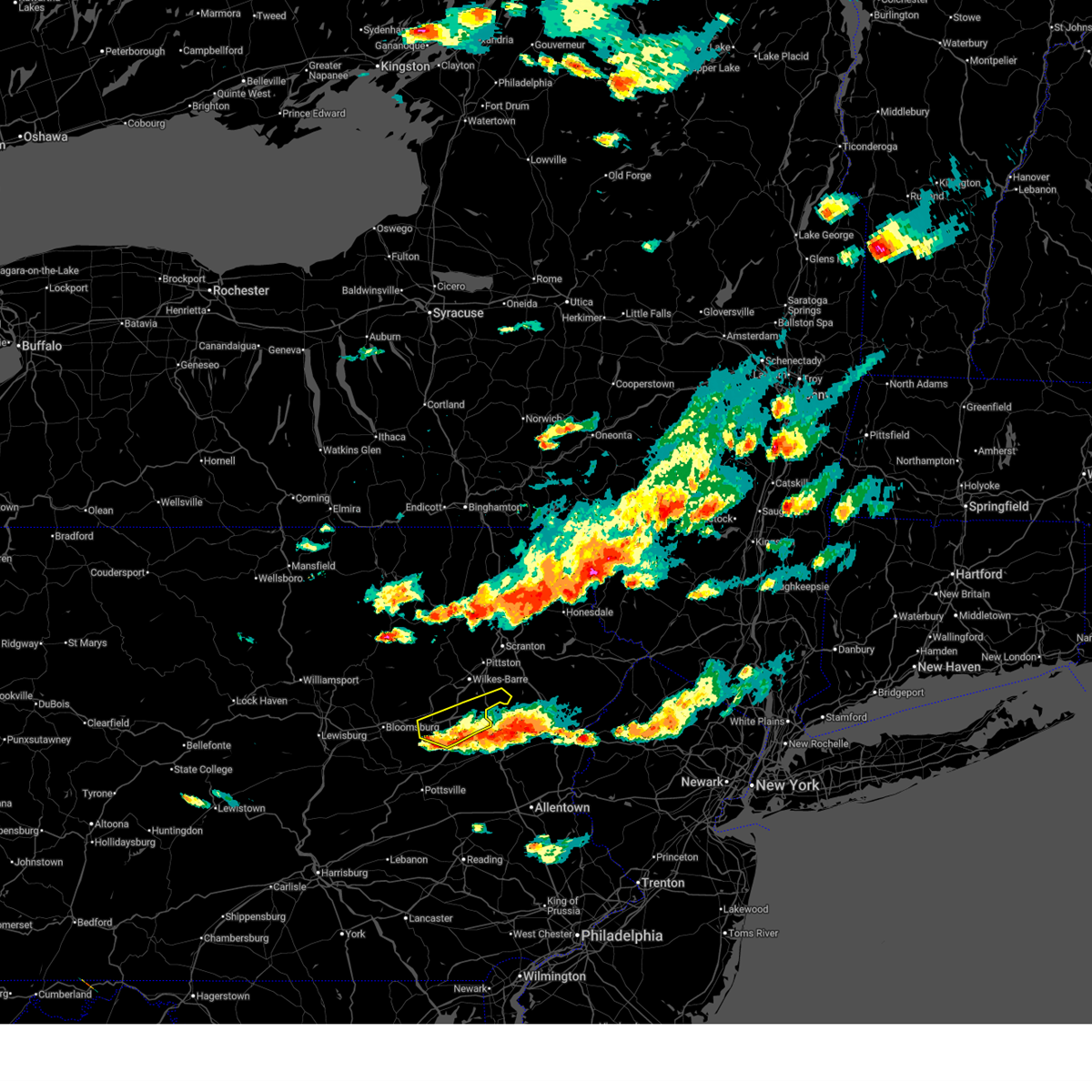
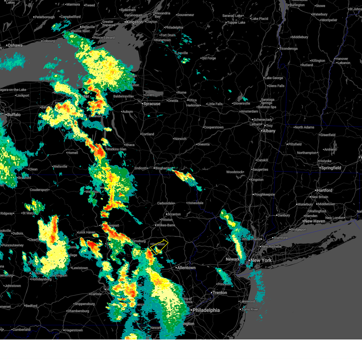
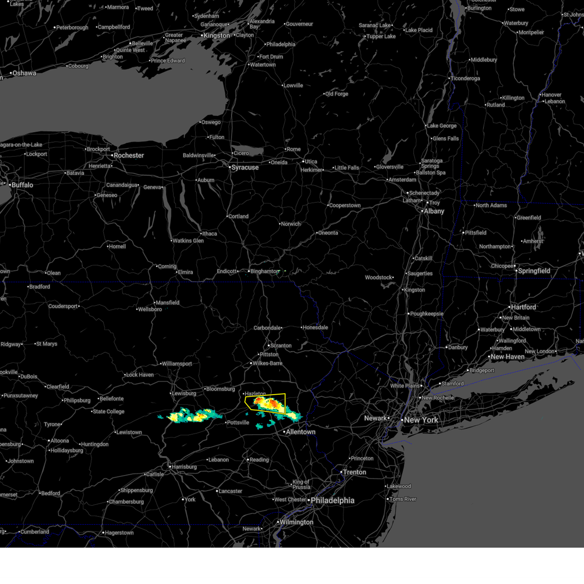
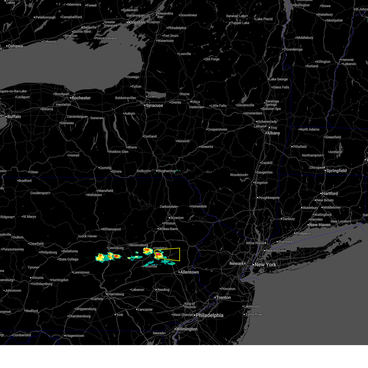
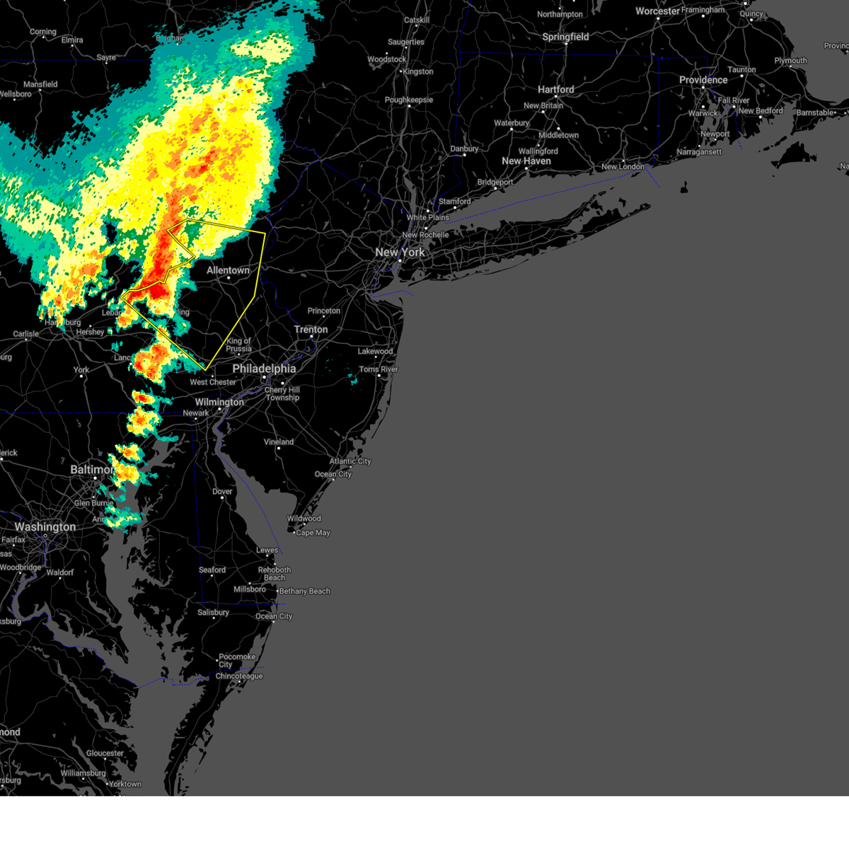
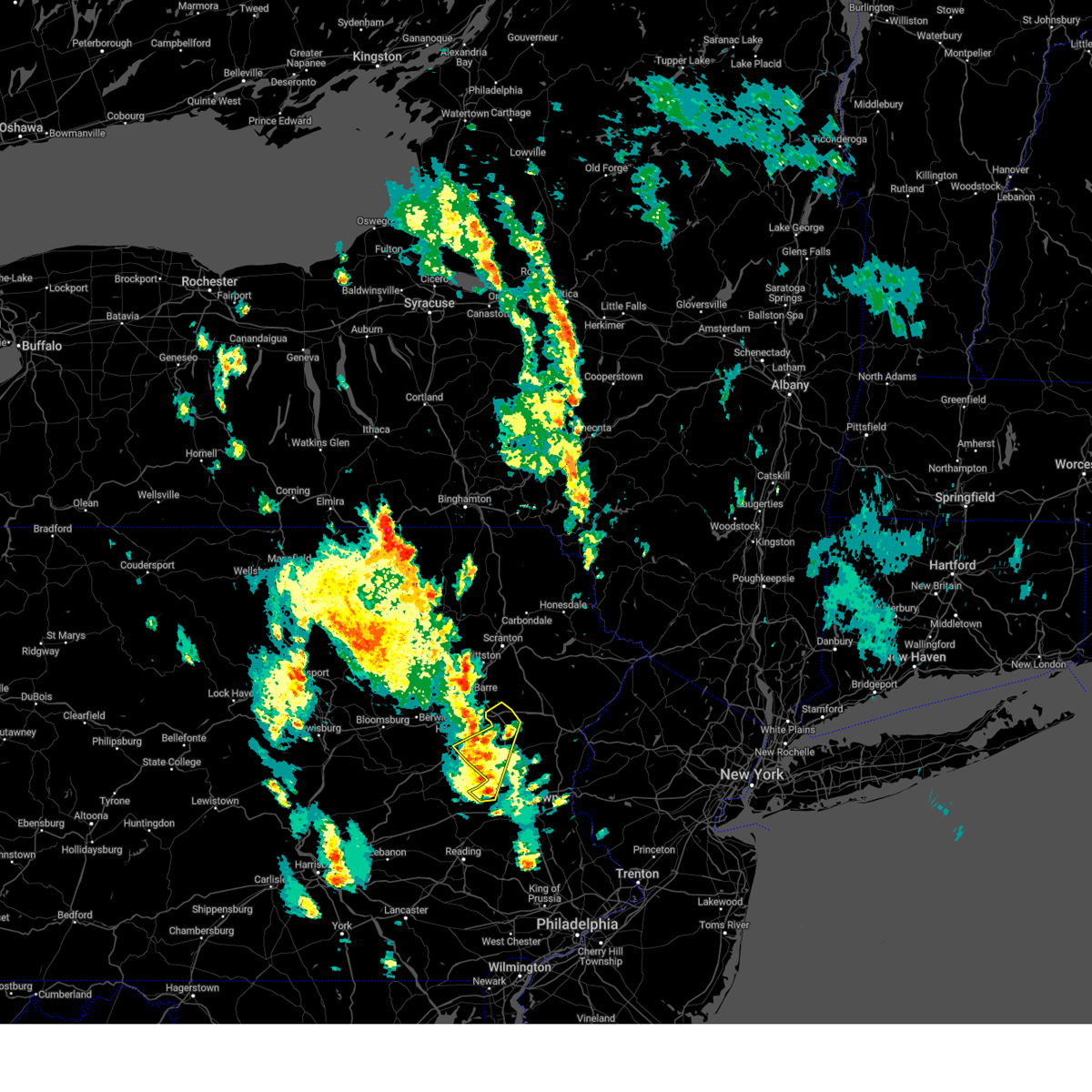
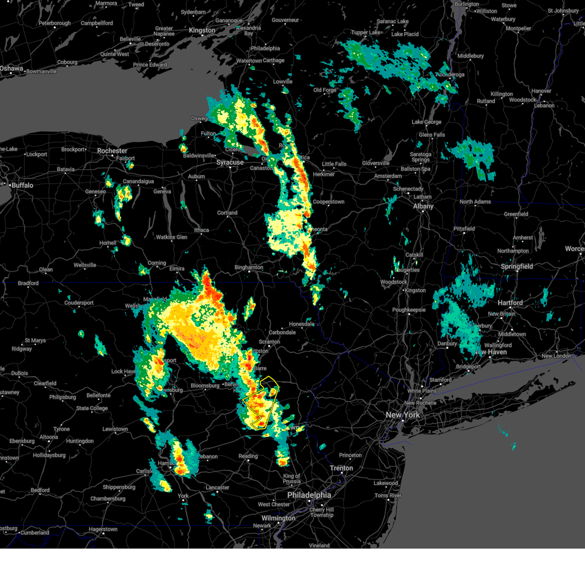
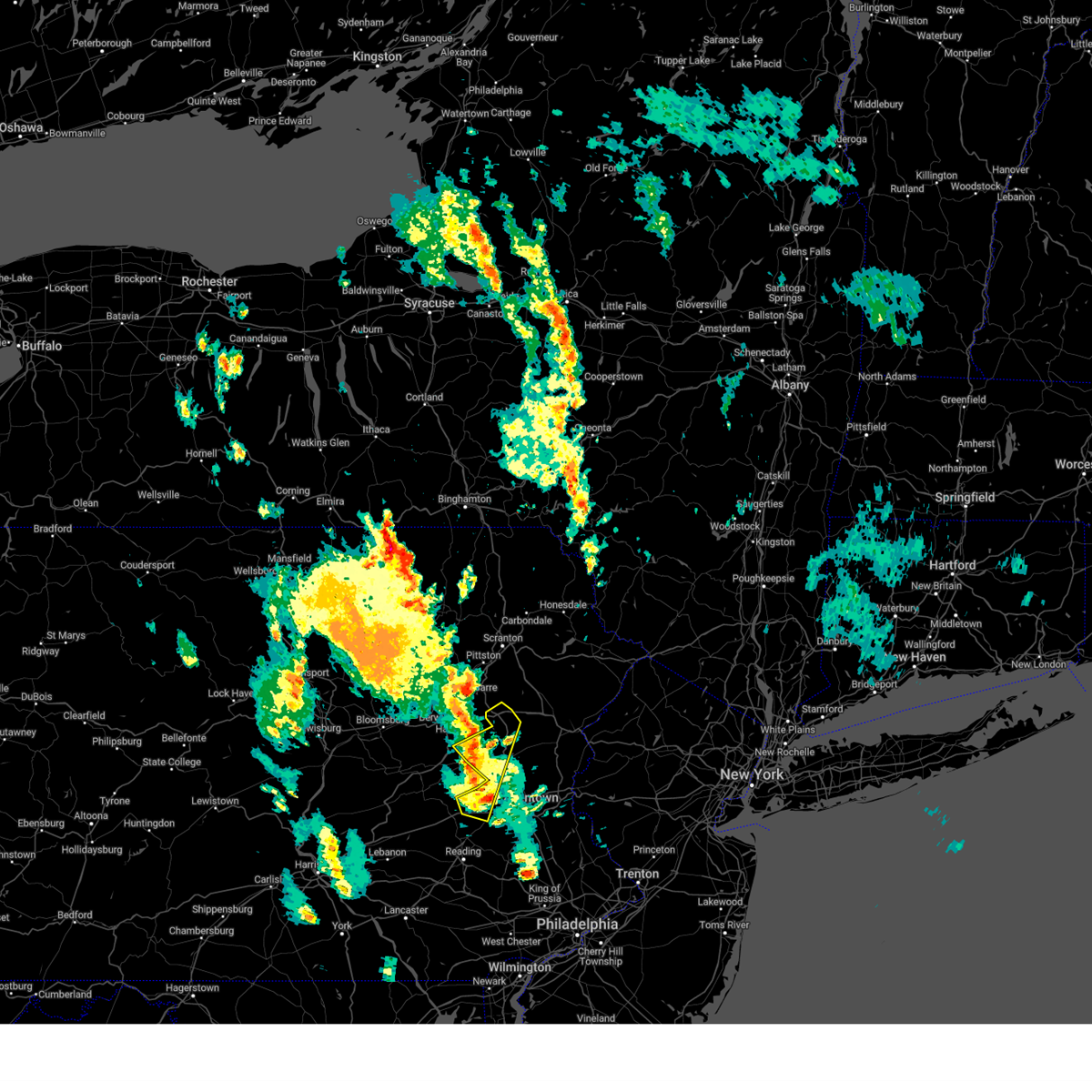
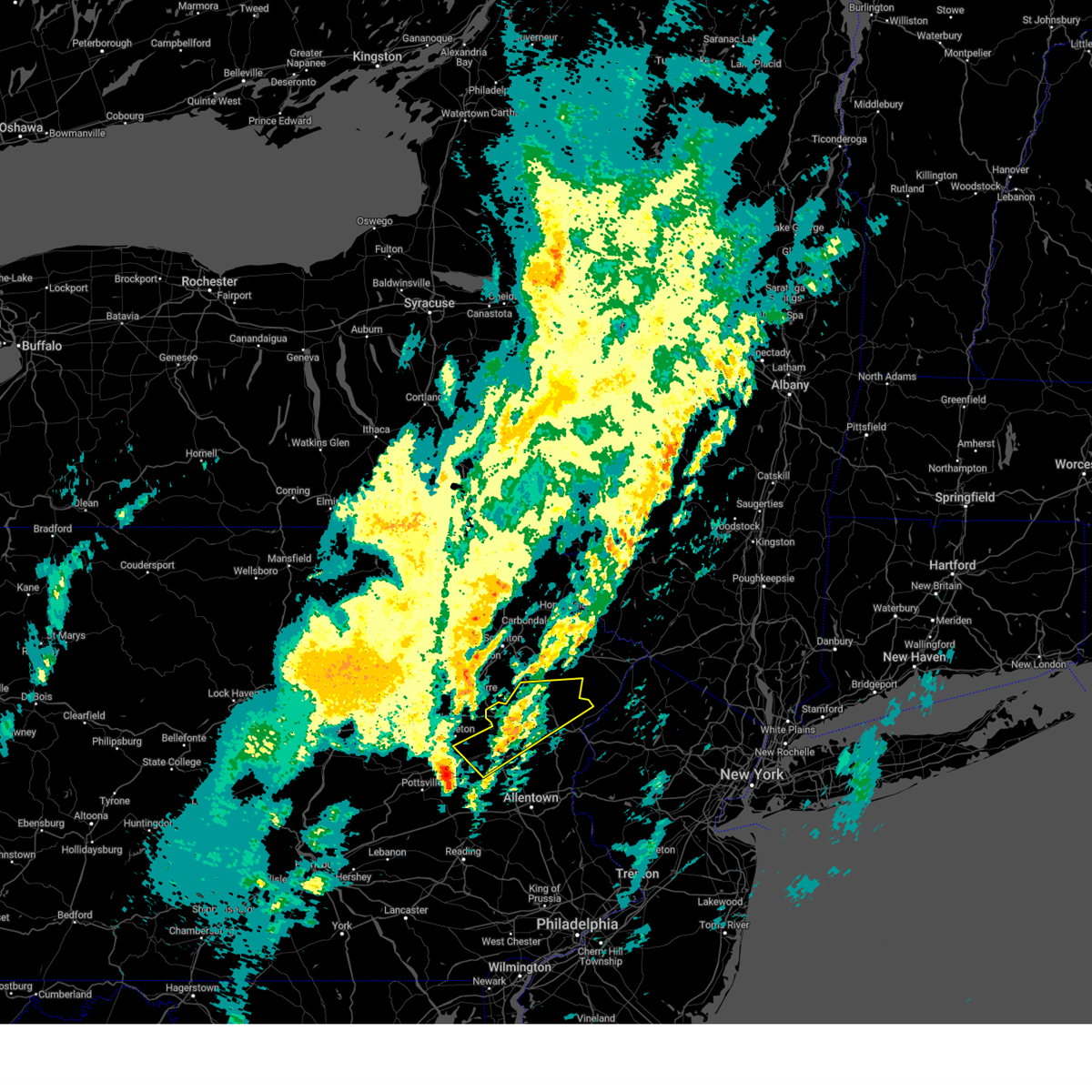
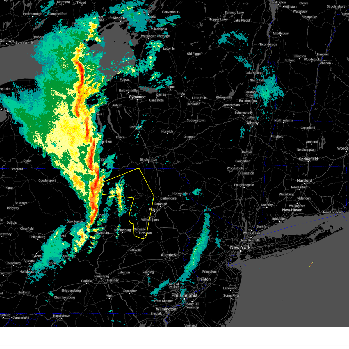
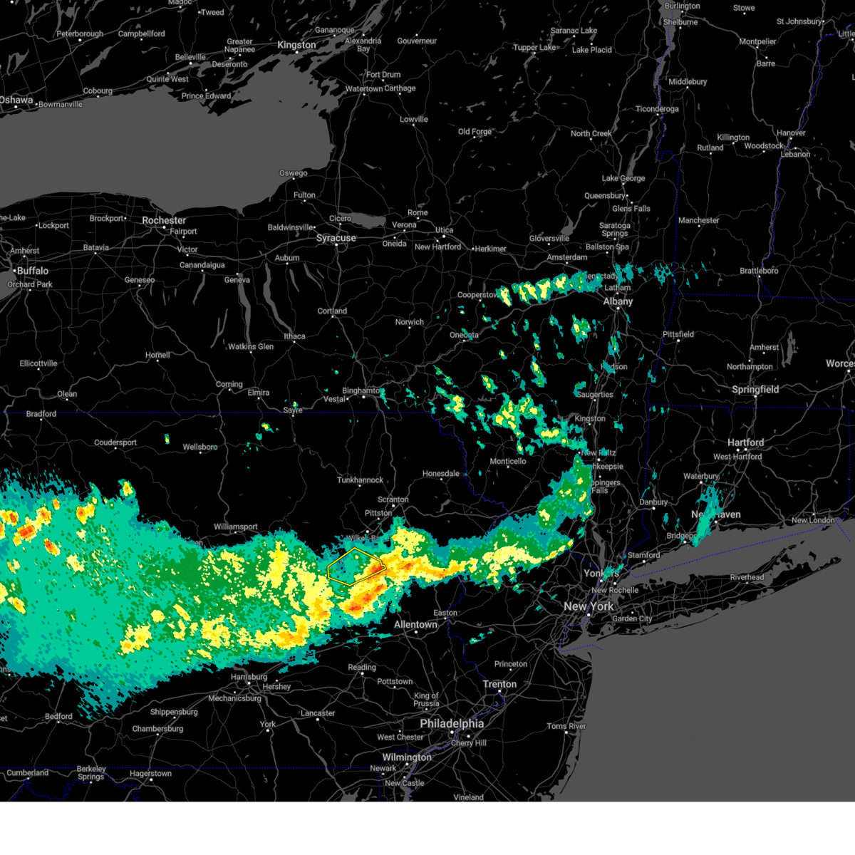
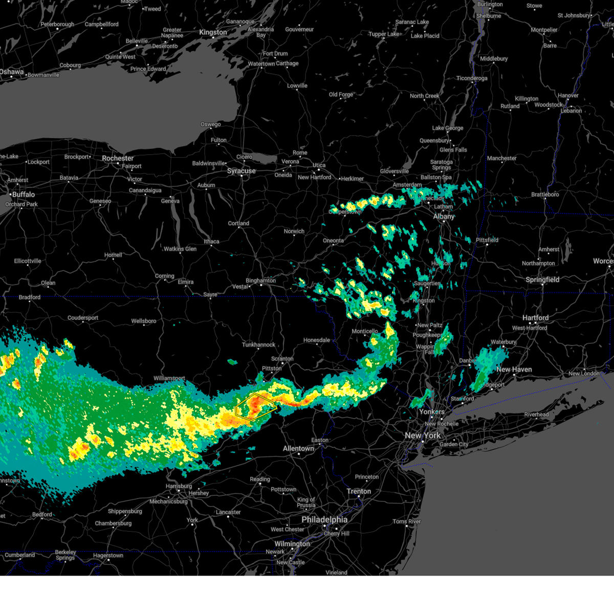
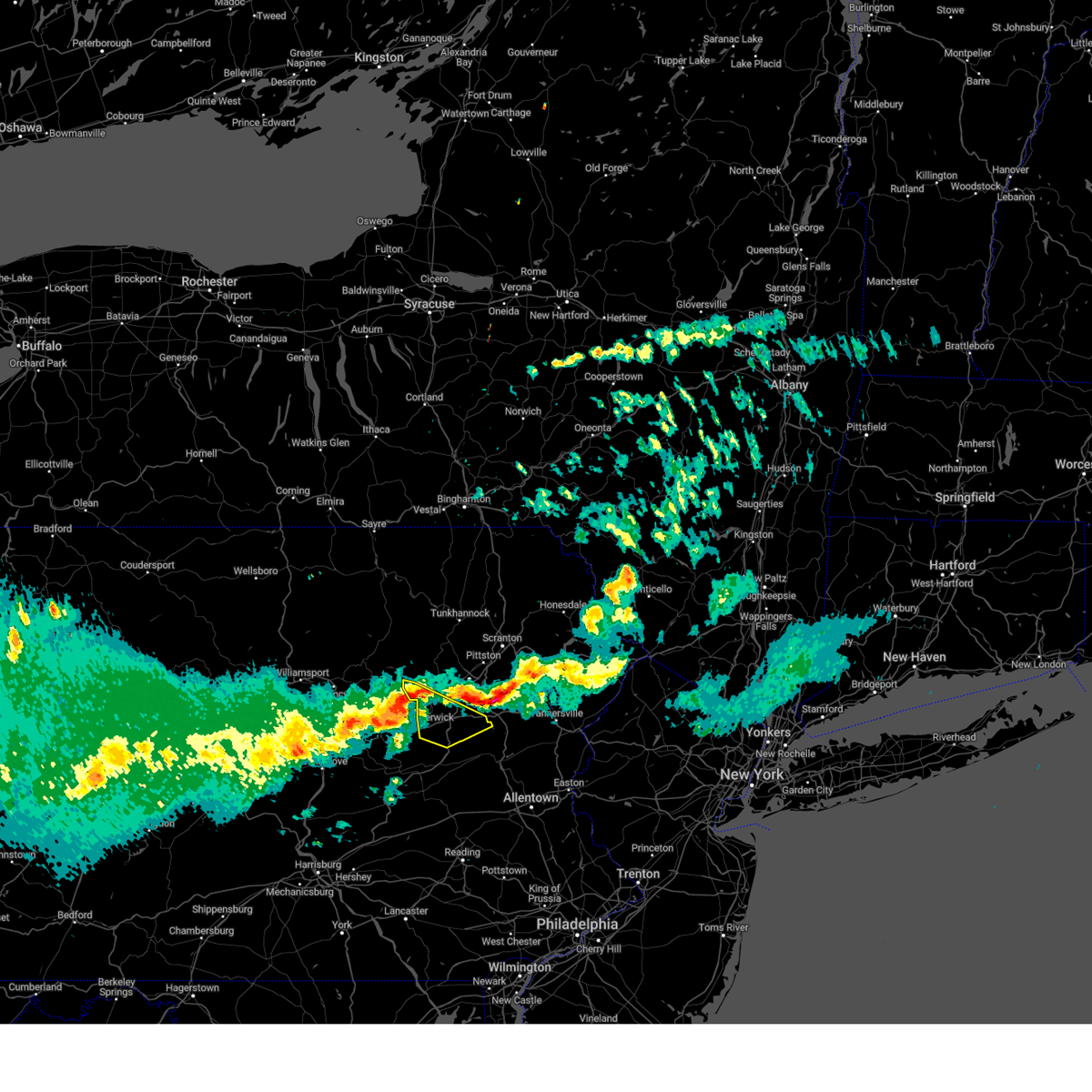
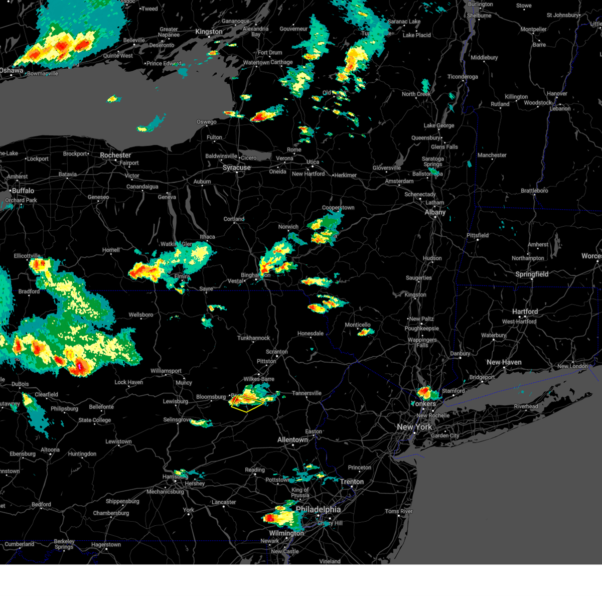
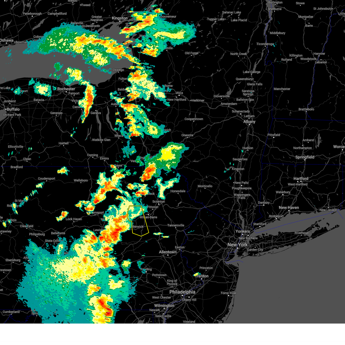
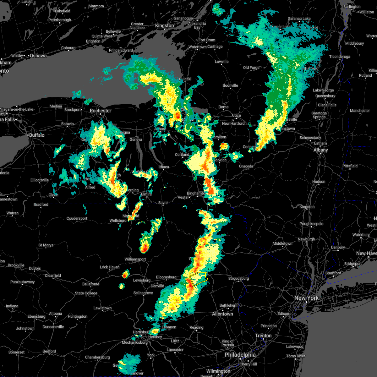
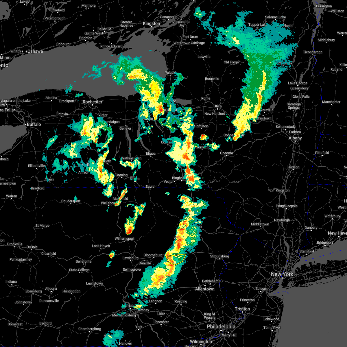
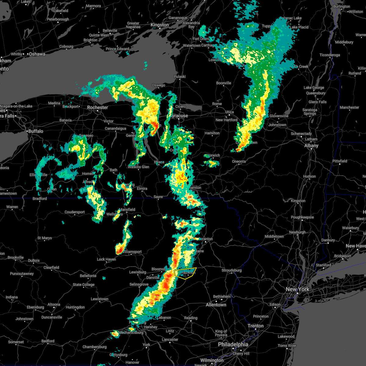
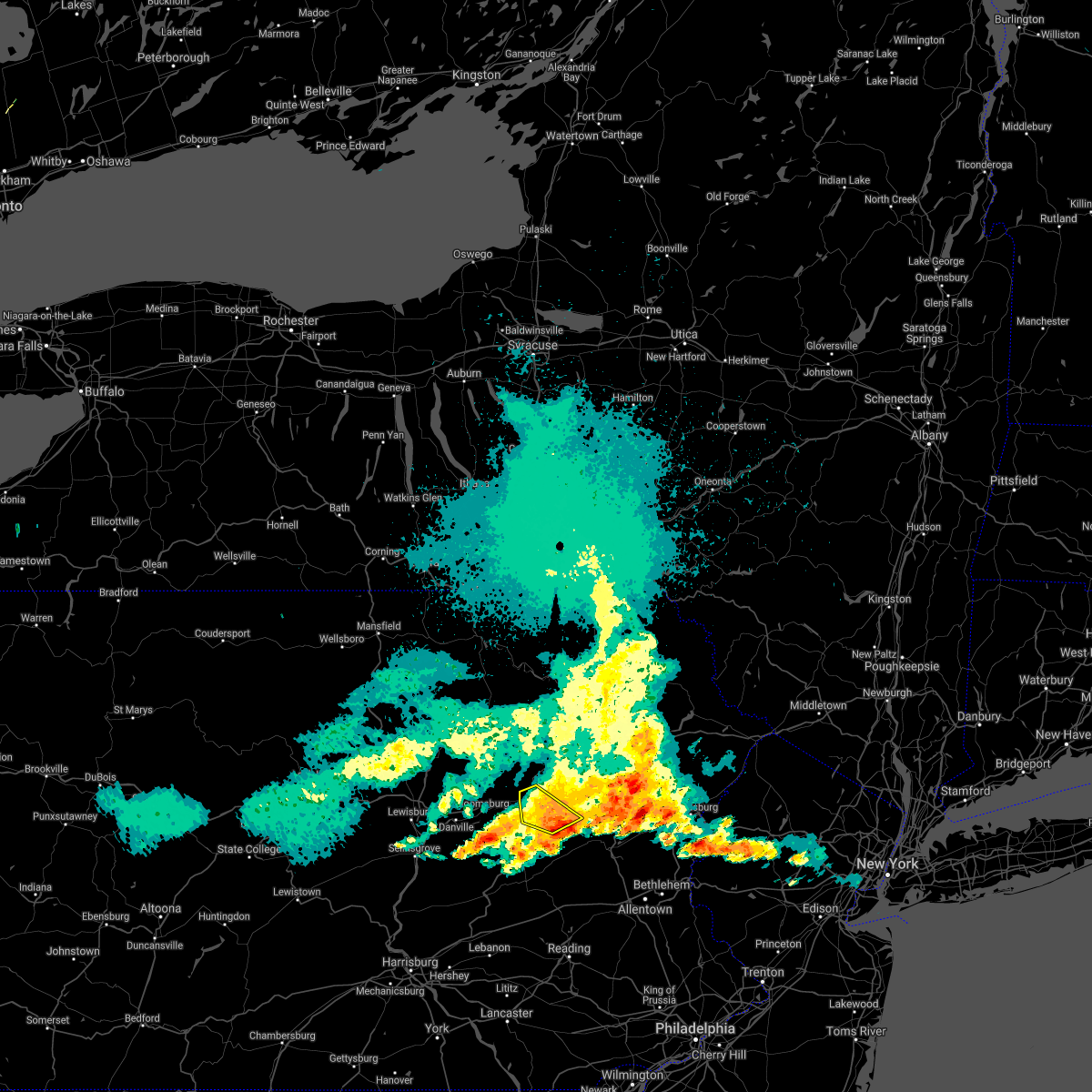
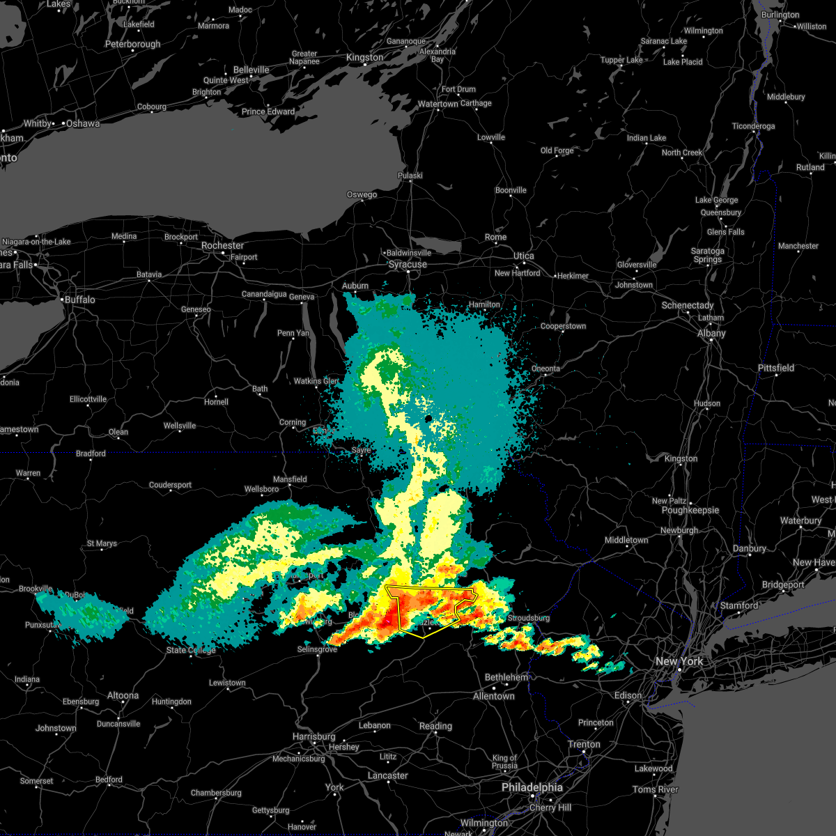
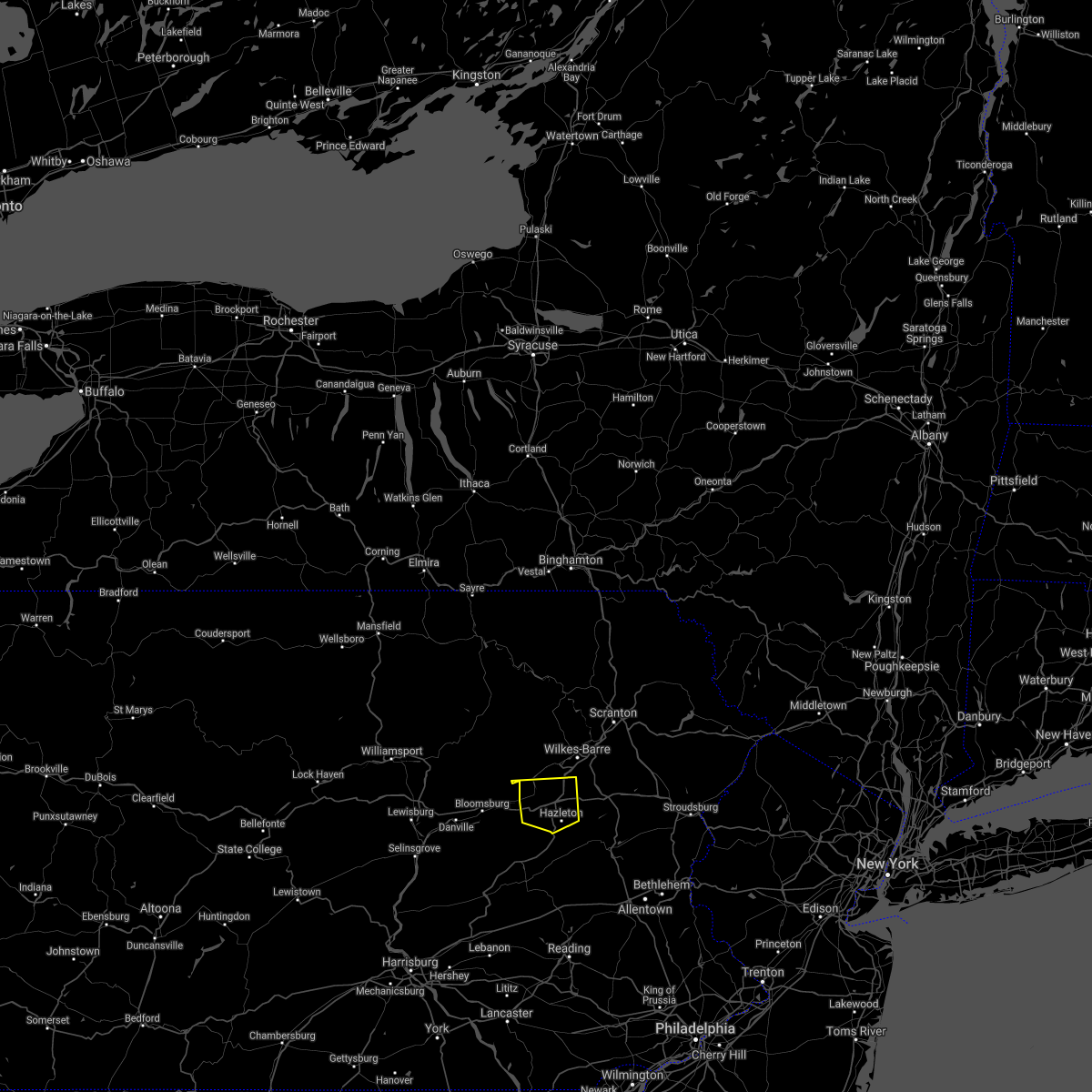
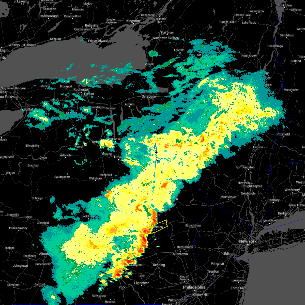
Hail Map for Tresckow, PA
The Tresckow, PA area has had 0 reports of on-the-ground hail by trained spotters, and has been under severe weather warnings 18 times during the past 12 months. Doppler radar has detected hail at or near Tresckow, PA on 26 occasions, including 3 occasions during the past year.
| Name: | Tresckow, PA |
| Where Located: | 37.4 miles SSW of Scranton, PA |
| Map: | Google Map for Tresckow, PA |
| Population: | 880 |
| Housing Units: | 424 |
| More Info: | Search Google for Tresckow, PA |
0
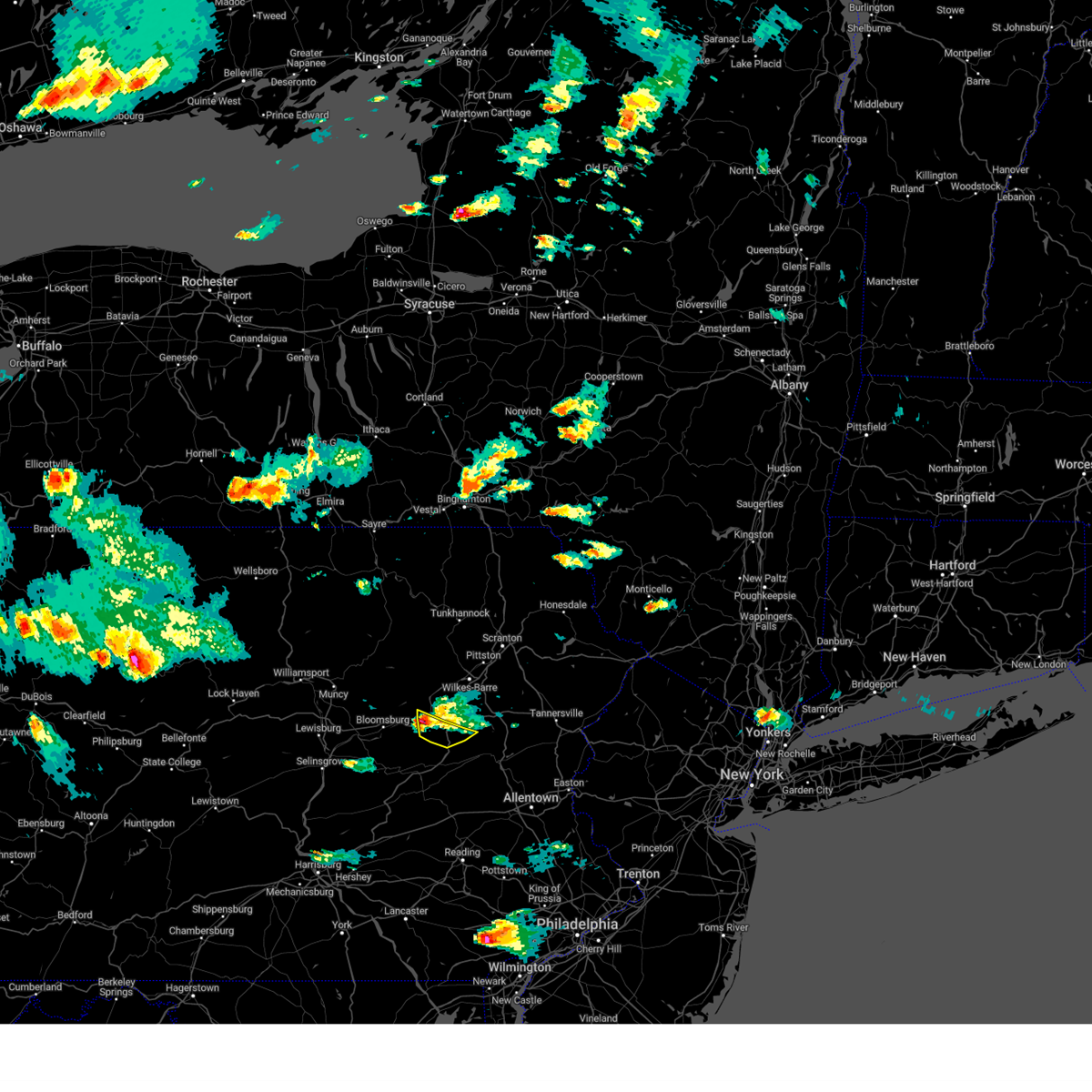
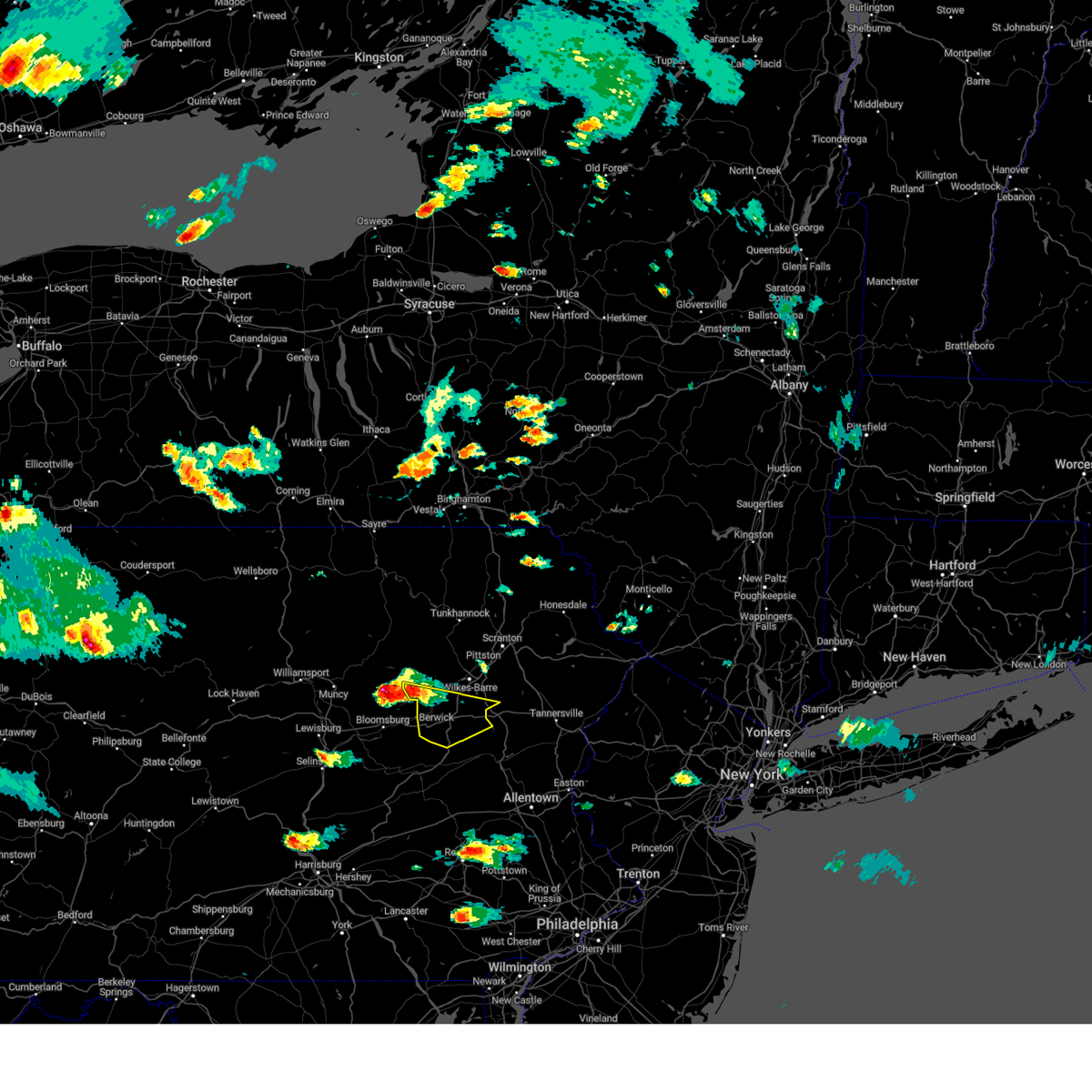
The Top Recent Hail Date for Tresckow, PA is Thursday, July 3, 2025 (19th out of 26)

Hail and Wind Damage Spotted near Tresckow, PA
| Date / Time | Report Details |
|---|---|
| 7/3/2025 4:21 PM EDT |
 The storms which prompted the warning have moved out of the area. therefore, the warning will be allowed to expire. a severe thunderstorm watch remains in effect until 1000 pm edt for northeastern pennsylvania. The storms which prompted the warning have moved out of the area. therefore, the warning will be allowed to expire. a severe thunderstorm watch remains in effect until 1000 pm edt for northeastern pennsylvania.
|
| 7/3/2025 4:21 PM EDT |
 At 420 pm edt, severe thunderstorms were located along a line extending from mcmichael to penn forest reservoir to near weatherly to sheppton, moving southeast at 25 mph (radar indicated). Hazards include 60 mph wind gusts and nickel size hail. Damage to roofs, siding, trees, and power lines is possible. Locations impacted include, lehighton, east stroudsburg, palmerton, jim thorpe, nesquehoning, wind gap, weatherly, stormville, brodheadsville, new mahoning, kunkletown, pocono pines, gilbert, pocono raceway, lake harmony, delaware water gap, tannersville, rossland, long pond, and albrightsville. At 420 pm edt, severe thunderstorms were located along a line extending from mcmichael to penn forest reservoir to near weatherly to sheppton, moving southeast at 25 mph (radar indicated). Hazards include 60 mph wind gusts and nickel size hail. Damage to roofs, siding, trees, and power lines is possible. Locations impacted include, lehighton, east stroudsburg, palmerton, jim thorpe, nesquehoning, wind gap, weatherly, stormville, brodheadsville, new mahoning, kunkletown, pocono pines, gilbert, pocono raceway, lake harmony, delaware water gap, tannersville, rossland, long pond, and albrightsville.
|
| 7/3/2025 3:56 PM EDT |
 Svrphi the national weather service in mount holly nj has issued a * severe thunderstorm warning for, carbon county in northeastern pennsylvania, central monroe county in northeastern pennsylvania, * until 445 pm edt. * at 355 pm edt, severe thunderstorms were located along a line extending from near stoddartsville to near white haven to near conyngham to mainville, moving east at 25 mph (radar indicated). Hazards include 60 mph wind gusts and nickel size hail. damage to roofs, siding, trees, and power lines is possible Svrphi the national weather service in mount holly nj has issued a * severe thunderstorm warning for, carbon county in northeastern pennsylvania, central monroe county in northeastern pennsylvania, * until 445 pm edt. * at 355 pm edt, severe thunderstorms were located along a line extending from near stoddartsville to near white haven to near conyngham to mainville, moving east at 25 mph (radar indicated). Hazards include 60 mph wind gusts and nickel size hail. damage to roofs, siding, trees, and power lines is possible
|
| 7/3/2025 3:55 PM EDT |
 Svrbgm the national weather service in binghamton has issued a * severe thunderstorm warning for, southern luzerne county in northeastern pennsylvania, * until 430 pm edt. * at 354 pm edt, severe thunderstorms were located along a line extending from near stoddartsville to near shumans, moving southeast at 20 mph (radar indicated). Hazards include 60 mph wind gusts and quarter size hail. Hail damage to vehicles is expected. Expect wind damage to roofs, siding, and trees. Svrbgm the national weather service in binghamton has issued a * severe thunderstorm warning for, southern luzerne county in northeastern pennsylvania, * until 430 pm edt. * at 354 pm edt, severe thunderstorms were located along a line extending from near stoddartsville to near shumans, moving southeast at 20 mph (radar indicated). Hazards include 60 mph wind gusts and quarter size hail. Hail damage to vehicles is expected. Expect wind damage to roofs, siding, and trees.
|
| 6/30/2025 7:42 PM EDT |
 At 742 pm edt, a severe thunderstorm was located near mcadoo, or near tamaqua, moving northeast at 25 mph (radar indicated). Hazards include 60 mph wind gusts and quarter size hail. Minor damage to vehicles is possible. wind damage to roofs, siding, trees, and power lines is possible. Locations impacted include, jim thorpe, nesquehoning, weatherly, christmans, lansford, summit hill, beaver meadows, and tresckow. At 742 pm edt, a severe thunderstorm was located near mcadoo, or near tamaqua, moving northeast at 25 mph (radar indicated). Hazards include 60 mph wind gusts and quarter size hail. Minor damage to vehicles is possible. wind damage to roofs, siding, trees, and power lines is possible. Locations impacted include, jim thorpe, nesquehoning, weatherly, christmans, lansford, summit hill, beaver meadows, and tresckow.
|
| 6/30/2025 7:30 PM EDT |
 Svrphi the national weather service in mount holly nj has issued a * severe thunderstorm warning for, southwestern carbon county in northeastern pennsylvania, * until 815 pm edt. * at 730 pm edt, a severe thunderstorm was located over hometown, or over tamaqua, moving northeast at 25 mph (radar indicated). Hazards include 60 mph wind gusts and quarter size hail. Minor damage to vehicles is possible. Wind damage to roofs, siding, trees, and power lines is possible. Svrphi the national weather service in mount holly nj has issued a * severe thunderstorm warning for, southwestern carbon county in northeastern pennsylvania, * until 815 pm edt. * at 730 pm edt, a severe thunderstorm was located over hometown, or over tamaqua, moving northeast at 25 mph (radar indicated). Hazards include 60 mph wind gusts and quarter size hail. Minor damage to vehicles is possible. Wind damage to roofs, siding, trees, and power lines is possible.
|
| 6/12/2025 6:55 PM EDT |
 The storms which prompted the warning have weakened below severe limits, and no longer poses an immediate threat to life or property. therefore, the warning will be allowed to expire. The storms which prompted the warning have weakened below severe limits, and no longer poses an immediate threat to life or property. therefore, the warning will be allowed to expire.
|
| 6/12/2025 6:43 PM EDT |
 At 641 pm edt, a severe thunderstorm was located over jim thorpe, or near lehighton, moving east at 30 mph. at this time there is also a second severe thunderstorm that is just starting to move into western carbon county within this warned area (radar indicated). Hazards include 60 mph wind gusts and quarter size hail. Minor damage to vehicles is possible. wind damage to roofs, siding, trees, and power lines is possible. Locations impacted include, lehighton, palmerton, jim thorpe, nesquehoning, weatherly, danielsville, beltzville state park, penn forest reservoir, kresgeville, lansford, summit hill, bowmanstown, beaver meadows, parryville, weissport, trachsville, and weissport east. At 641 pm edt, a severe thunderstorm was located over jim thorpe, or near lehighton, moving east at 30 mph. at this time there is also a second severe thunderstorm that is just starting to move into western carbon county within this warned area (radar indicated). Hazards include 60 mph wind gusts and quarter size hail. Minor damage to vehicles is possible. wind damage to roofs, siding, trees, and power lines is possible. Locations impacted include, lehighton, palmerton, jim thorpe, nesquehoning, weatherly, danielsville, beltzville state park, penn forest reservoir, kresgeville, lansford, summit hill, bowmanstown, beaver meadows, parryville, weissport, trachsville, and weissport east.
|
| 6/12/2025 6:25 PM EDT |
 Svrphi the national weather service in mount holly nj has issued a * severe thunderstorm warning for, southern carbon county in northeastern pennsylvania, southwestern monroe county in northeastern pennsylvania, west central northampton county in eastern pennsylvania, * until 700 pm edt. * at 624 pm edt, a severe thunderstorm was located over nesquehoning, or 7 miles northeast of tamaqua, moving east at 30 mph (radar indicated). Hazards include 60 mph wind gusts and quarter size hail. Minor damage to vehicles is possible. Wind damage to roofs, siding, trees, and power lines is possible. Svrphi the national weather service in mount holly nj has issued a * severe thunderstorm warning for, southern carbon county in northeastern pennsylvania, southwestern monroe county in northeastern pennsylvania, west central northampton county in eastern pennsylvania, * until 700 pm edt. * at 624 pm edt, a severe thunderstorm was located over nesquehoning, or 7 miles northeast of tamaqua, moving east at 30 mph (radar indicated). Hazards include 60 mph wind gusts and quarter size hail. Minor damage to vehicles is possible. Wind damage to roofs, siding, trees, and power lines is possible.
|
| 5/16/2025 10:24 AM EDT |
 Svrphi the national weather service in mount holly nj has issued a * severe thunderstorm warning for, berks county in eastern pennsylvania, lehigh county in eastern pennsylvania, northwestern montgomery county in southeastern pennsylvania, carbon county in northeastern pennsylvania, northwestern bucks county in southeastern pennsylvania, north central chester county in southeastern pennsylvania, southwestern monroe county in northeastern pennsylvania, northampton county in eastern pennsylvania, * until 1130 am edt. * at 1024 am edt, severe thunderstorms were located along a line extending from near hazleton to near mckeansburg to near strausstown, moving east at 40 mph (radar indicated). Hazards include 60 mph wind gusts and quarter size hail. Minor damage to vehicles is possible. Wind damage to roofs, siding, trees, and power lines is possible. Svrphi the national weather service in mount holly nj has issued a * severe thunderstorm warning for, berks county in eastern pennsylvania, lehigh county in eastern pennsylvania, northwestern montgomery county in southeastern pennsylvania, carbon county in northeastern pennsylvania, northwestern bucks county in southeastern pennsylvania, north central chester county in southeastern pennsylvania, southwestern monroe county in northeastern pennsylvania, northampton county in eastern pennsylvania, * until 1130 am edt. * at 1024 am edt, severe thunderstorms were located along a line extending from near hazleton to near mckeansburg to near strausstown, moving east at 40 mph (radar indicated). Hazards include 60 mph wind gusts and quarter size hail. Minor damage to vehicles is possible. Wind damage to roofs, siding, trees, and power lines is possible.
|
| 5/6/2025 2:58 PM EDT |
 the severe thunderstorm warning has been cancelled and is no longer in effect the severe thunderstorm warning has been cancelled and is no longer in effect
|
| 5/6/2025 2:58 PM EDT |
 At 257 pm edt, severe thunderstorms were located along a line extending from near jim thorpe to new tripoli, moving north at 35 mph (radar indicated). Hazards include 60 mph wind gusts and quarter size hail. Minor damage to vehicles is possible. wind damage to roofs, siding, trees, and power lines is possible. locations impacted include, lehighton, new mahoning, beaver meadows, wanamakers, jim thorpe, lake harmony, new tripoli, summit hill, bowmanstown, weissport, weatherly, parryville, jordan valley, nesquehoning, weissport east, albrightsville, tresckow, christmans, lansford, and meckesville. this includes the following highways, northeast extension between mile markers 71 and 97. Interstate 80 in pennsylvania between mile markers 277 and 287. At 257 pm edt, severe thunderstorms were located along a line extending from near jim thorpe to new tripoli, moving north at 35 mph (radar indicated). Hazards include 60 mph wind gusts and quarter size hail. Minor damage to vehicles is possible. wind damage to roofs, siding, trees, and power lines is possible. locations impacted include, lehighton, new mahoning, beaver meadows, wanamakers, jim thorpe, lake harmony, new tripoli, summit hill, bowmanstown, weissport, weatherly, parryville, jordan valley, nesquehoning, weissport east, albrightsville, tresckow, christmans, lansford, and meckesville. this includes the following highways, northeast extension between mile markers 71 and 97. Interstate 80 in pennsylvania between mile markers 277 and 287.
|
| 5/6/2025 2:46 PM EDT |
 Svrphi the national weather service in mount holly nj has issued a * severe thunderstorm warning for, north central berks county in eastern pennsylvania, northwestern lehigh county in eastern pennsylvania, carbon county in northeastern pennsylvania, * until 345 pm edt. * at 246 pm edt, severe thunderstorms were located along a line extending from near new mahoning to near lenhartsville, moving north at 35 mph (radar indicated). Hazards include 60 mph wind gusts and quarter size hail. Minor damage to vehicles is possible. Wind damage to roofs, siding, trees, and power lines is possible. Svrphi the national weather service in mount holly nj has issued a * severe thunderstorm warning for, north central berks county in eastern pennsylvania, northwestern lehigh county in eastern pennsylvania, carbon county in northeastern pennsylvania, * until 345 pm edt. * at 246 pm edt, severe thunderstorms were located along a line extending from near new mahoning to near lenhartsville, moving north at 35 mph (radar indicated). Hazards include 60 mph wind gusts and quarter size hail. Minor damage to vehicles is possible. Wind damage to roofs, siding, trees, and power lines is possible.
|
| 4/29/2025 8:50 PM EDT | The storms which prompted the warning have weakened below severe limits, and no longer pose an immediate threat to life or property. therefore, the warning will be allowed to expire. |
| 4/29/2025 8:15 PM EDT | Svrphi the national weather service in mount holly nj has issued a * severe thunderstorm warning for, northern berks county in eastern pennsylvania, lehigh county in eastern pennsylvania, carbon county in northeastern pennsylvania, monroe county in northeastern pennsylvania, northwestern northampton county in eastern pennsylvania, * until 900 pm edt. * at 814 pm edt, severe thunderstorms were located along a line extending from sweet valley to near nuremburg to near pine grove, moving east at 70 mph (radar indicated). Hazards include 60 mph wind gusts. damage to roofs, siding, trees, and power lines is possible |
| 4/29/2025 7:59 PM EDT | Svrbgm the national weather service in binghamton has issued a * severe thunderstorm warning for, western lackawanna county in northeastern pennsylvania, luzerne county in northeastern pennsylvania, southern bradford county in northeastern pennsylvania, wyoming county in northeastern pennsylvania, * until 845 pm edt. * at 758 pm edt, severe thunderstorms were located along a line extending from near lincoln falls to eyers grove to klingerstown, moving east at 70 mph (radar indicated). Hazards include 60 mph wind gusts. expect damage to roofs, siding, and trees |
| 3/16/2025 9:02 PM EDT |
 Svrphi the national weather service in mount holly nj has issued a * severe thunderstorm warning for, carbon county in northeastern pennsylvania, monroe county in northeastern pennsylvania, * until 1000 pm edt. * at 902 pm edt, a severe thunderstorm was located over hometown, or over tamaqua, moving northeast at 65 mph (radar indicated). Hazards include 60 mph wind gusts and quarter size hail. Minor damage to vehicles is possible. Wind damage to roofs, siding, trees, and power lines is possible. Svrphi the national weather service in mount holly nj has issued a * severe thunderstorm warning for, carbon county in northeastern pennsylvania, monroe county in northeastern pennsylvania, * until 1000 pm edt. * at 902 pm edt, a severe thunderstorm was located over hometown, or over tamaqua, moving northeast at 65 mph (radar indicated). Hazards include 60 mph wind gusts and quarter size hail. Minor damage to vehicles is possible. Wind damage to roofs, siding, trees, and power lines is possible.
|
| 3/16/2025 3:59 PM EDT |
 Svrbgm the national weather service in binghamton has issued a * severe thunderstorm warning for, western susquehanna county in northeastern pennsylvania, luzerne county in northeastern pennsylvania, bradford county in northeastern pennsylvania, wyoming county in northeastern pennsylvania, * until 500 pm edt. * at 358 pm edt, severe thunderstorms were located along a line extending from near sylvania to near elimsport, moving east at 50 mph (radar indicated). Hazards include 60 mph wind gusts. expect damage to roofs, siding, and trees Svrbgm the national weather service in binghamton has issued a * severe thunderstorm warning for, western susquehanna county in northeastern pennsylvania, luzerne county in northeastern pennsylvania, bradford county in northeastern pennsylvania, wyoming county in northeastern pennsylvania, * until 500 pm edt. * at 358 pm edt, severe thunderstorms were located along a line extending from near sylvania to near elimsport, moving east at 50 mph (radar indicated). Hazards include 60 mph wind gusts. expect damage to roofs, siding, and trees
|
| 6/29/2024 6:09 PM EDT |
 Svrphi the national weather service in mount holly nj has issued a * severe thunderstorm warning for, northern berks county in eastern pennsylvania, northwestern lehigh county in eastern pennsylvania, southwestern carbon county in northeastern pennsylvania, * until 700 pm edt. * at 608 pm edt, severe thunderstorms were located along a line extending from near marshallton to near donaldson to near dehart dam, moving east at 45 mph (radar indicated). Hazards include 60 mph wind gusts. damage to roofs, siding, trees, and power lines is possible Svrphi the national weather service in mount holly nj has issued a * severe thunderstorm warning for, northern berks county in eastern pennsylvania, northwestern lehigh county in eastern pennsylvania, southwestern carbon county in northeastern pennsylvania, * until 700 pm edt. * at 608 pm edt, severe thunderstorms were located along a line extending from near marshallton to near donaldson to near dehart dam, moving east at 45 mph (radar indicated). Hazards include 60 mph wind gusts. damage to roofs, siding, trees, and power lines is possible
|
| 6/26/2024 6:35 PM EDT |
 At 634 pm edt, severe thunderstorms were located along a line extending from near muhlenberg to new mahoning to spring ridge, moving northeast at 50 mph (emergency management). Hazards include 60 mph wind gusts. Damage to roofs, siding, trees, and power lines is possible. locations impacted include, allentown, reading, lehighton, bethlehem, emmaus, wyomissing, northampton, tobyhanna, palmerton, kutztown, jim thorpe, hamburg, slatington, fleetwood, sinking spring, laureldale, nesquehoning, bath, weatherly, and walnutport. this includes the following highways, northeast extension between mile markers 49 and 97. interstate 78 in pennsylvania between mile markers 28 and 60. interstate 80 in pennsylvania between mile markers 278 and 299. interstate 380 in pennsylvania between mile markers 0 and 13. Interstate 176 in pennsylvania near mile marker 11. At 634 pm edt, severe thunderstorms were located along a line extending from near muhlenberg to new mahoning to spring ridge, moving northeast at 50 mph (emergency management). Hazards include 60 mph wind gusts. Damage to roofs, siding, trees, and power lines is possible. locations impacted include, allentown, reading, lehighton, bethlehem, emmaus, wyomissing, northampton, tobyhanna, palmerton, kutztown, jim thorpe, hamburg, slatington, fleetwood, sinking spring, laureldale, nesquehoning, bath, weatherly, and walnutport. this includes the following highways, northeast extension between mile markers 49 and 97. interstate 78 in pennsylvania between mile markers 28 and 60. interstate 80 in pennsylvania between mile markers 278 and 299. interstate 380 in pennsylvania between mile markers 0 and 13. Interstate 176 in pennsylvania near mile marker 11.
|
| 6/26/2024 6:14 PM EDT |
 Svrphi the national weather service in mount holly nj has issued a * severe thunderstorm warning for, berks county in eastern pennsylvania, lehigh county in eastern pennsylvania, carbon county in northeastern pennsylvania, western monroe county in northeastern pennsylvania, west central northampton county in eastern pennsylvania, * until 700 pm edt. * at 613 pm edt, severe thunderstorms were located along a line extending from near rohrsburg to renningers to brickerville, moving northeast at 50 mph (radar indicated). Hazards include 60 mph wind gusts. damage to roofs, siding, trees, and power lines is possible Svrphi the national weather service in mount holly nj has issued a * severe thunderstorm warning for, berks county in eastern pennsylvania, lehigh county in eastern pennsylvania, carbon county in northeastern pennsylvania, western monroe county in northeastern pennsylvania, west central northampton county in eastern pennsylvania, * until 700 pm edt. * at 613 pm edt, severe thunderstorms were located along a line extending from near rohrsburg to renningers to brickerville, moving northeast at 50 mph (radar indicated). Hazards include 60 mph wind gusts. damage to roofs, siding, trees, and power lines is possible
|
| 5/27/2024 8:14 PM EDT |
 At 813 pm edt, a severe thunderstorm was located over nesquehoning, or near tamaqua, moving east at 25 mph (radar indicated). Hazards include 60 mph wind gusts. Damage to roofs, siding, trees, and power lines is possible. locations impacted include, lehighton, palmerton, jim thorpe, nesquehoning, weatherly, new mahoning, kunkletown, gilbert, pocono raceway, lake harmony, albrightsville, kresgeville, sun valley, jonas, meckesville, beltzville state park, penn forest reservoir, christmans, lansford, and summit hill. this includes the following highways, northeast extension between mile markers 73 and 91. Interstate 80 in pennsylvania between mile markers 288 and 291. At 813 pm edt, a severe thunderstorm was located over nesquehoning, or near tamaqua, moving east at 25 mph (radar indicated). Hazards include 60 mph wind gusts. Damage to roofs, siding, trees, and power lines is possible. locations impacted include, lehighton, palmerton, jim thorpe, nesquehoning, weatherly, new mahoning, kunkletown, gilbert, pocono raceway, lake harmony, albrightsville, kresgeville, sun valley, jonas, meckesville, beltzville state park, penn forest reservoir, christmans, lansford, and summit hill. this includes the following highways, northeast extension between mile markers 73 and 91. Interstate 80 in pennsylvania between mile markers 288 and 291.
|
| 5/27/2024 8:04 PM EDT |
 Svrphi the national weather service in mount holly nj has issued a * severe thunderstorm warning for, carbon county in northeastern pennsylvania, southwestern monroe county in northeastern pennsylvania, * until 845 pm edt. * at 804 pm edt, a severe thunderstorm was located over hometown, or near tamaqua, moving east at 20 mph (radar indicated). Hazards include 60 mph wind gusts. damage to roofs, siding, trees, and power lines is possible Svrphi the national weather service in mount holly nj has issued a * severe thunderstorm warning for, carbon county in northeastern pennsylvania, southwestern monroe county in northeastern pennsylvania, * until 845 pm edt. * at 804 pm edt, a severe thunderstorm was located over hometown, or near tamaqua, moving east at 20 mph (radar indicated). Hazards include 60 mph wind gusts. damage to roofs, siding, trees, and power lines is possible
|
| 4/14/2024 7:46 PM EDT |
 the severe thunderstorm warning has been cancelled and is no longer in effect the severe thunderstorm warning has been cancelled and is no longer in effect
|
| 4/14/2024 7:34 PM EDT |
 At 734 pm edt, a severe thunderstorm was located over mountain top, or 9 miles north of hazleton, moving east at 50 mph (radar indicated). Hazards include 60 mph wind gusts and penny size hail. Expect damage to roofs, siding, and trees. Locations impacted include, hazleton, west hazleton, freeland, dorrance, conyngham, white haven, jeddo, mountain top, woodside-drifton, and drifton. At 734 pm edt, a severe thunderstorm was located over mountain top, or 9 miles north of hazleton, moving east at 50 mph (radar indicated). Hazards include 60 mph wind gusts and penny size hail. Expect damage to roofs, siding, and trees. Locations impacted include, hazleton, west hazleton, freeland, dorrance, conyngham, white haven, jeddo, mountain top, woodside-drifton, and drifton.
|
| 4/14/2024 7:17 PM EDT |
 Svrbgm the national weather service in binghamton has issued a * severe thunderstorm warning for, southern luzerne county in northeastern pennsylvania, * until 800 pm edt. * at 716 pm edt, a severe thunderstorm was located over huntington mills, or near berwick, moving east at 50 mph (radar indicated). Hazards include 60 mph wind gusts and nickel size hail. expect damage to roofs, siding, and trees Svrbgm the national weather service in binghamton has issued a * severe thunderstorm warning for, southern luzerne county in northeastern pennsylvania, * until 800 pm edt. * at 716 pm edt, a severe thunderstorm was located over huntington mills, or near berwick, moving east at 50 mph (radar indicated). Hazards include 60 mph wind gusts and nickel size hail. expect damage to roofs, siding, and trees
|
| 9/7/2023 3:20 PM EDT |
 At 320 pm edt, a severe thunderstorm was located over mcadoo, or over hazleton, moving north at 30 mph (radar indicated). Hazards include 60 mph wind gusts and quarter size hail. Hail damage to vehicles is expected. Expect wind damage to roofs, siding, and trees. At 320 pm edt, a severe thunderstorm was located over mcadoo, or over hazleton, moving north at 30 mph (radar indicated). Hazards include 60 mph wind gusts and quarter size hail. Hail damage to vehicles is expected. Expect wind damage to roofs, siding, and trees.
|
| 8/12/2023 5:36 PM EDT |
 The severe thunderstorm warning for southern carbon county will expire at 545 pm edt, the storm which prompted the warning has weakened below severe limits, and has exited the warned area. therefore, the warning will be allowed to expire. to report severe weather, contact your nearest law enforcement agency. they will relay your report to the national weather service mount holly nj. The severe thunderstorm warning for southern carbon county will expire at 545 pm edt, the storm which prompted the warning has weakened below severe limits, and has exited the warned area. therefore, the warning will be allowed to expire. to report severe weather, contact your nearest law enforcement agency. they will relay your report to the national weather service mount holly nj.
|
| 8/12/2023 4:57 PM EDT |
 At 457 pm edt, a severe thunderstorm was located over west hazleton, or over hazleton, moving southeast at 25 mph (radar indicated). Hazards include 60 mph wind gusts and quarter size hail. Minor damage to vehicles is possible. Wind damage to roofs, siding, trees, and power lines is possible. At 457 pm edt, a severe thunderstorm was located over west hazleton, or over hazleton, moving southeast at 25 mph (radar indicated). Hazards include 60 mph wind gusts and quarter size hail. Minor damage to vehicles is possible. Wind damage to roofs, siding, trees, and power lines is possible.
|
| 8/12/2023 4:44 PM EDT |
 At 444 pm edt, a severe thunderstorm was located over rock glen, or near berwick, moving east at 35 mph (radar indicated). Hazards include 60 mph wind gusts and quarter size hail. Hail damage to vehicles is expected. Expect wind damage to roofs, siding, and trees. At 444 pm edt, a severe thunderstorm was located over rock glen, or near berwick, moving east at 35 mph (radar indicated). Hazards include 60 mph wind gusts and quarter size hail. Hail damage to vehicles is expected. Expect wind damage to roofs, siding, and trees.
|
| 8/12/2023 4:37 PM EDT |
 At 437 pm edt, a severe thunderstorm was located near rock glen, or near berwick, moving southeast at 20 mph (radar indicated). Hazards include 60 mph wind gusts and quarter size hail. Hail damage to vehicles is expected. expect wind damage to roofs, siding, and trees. Locations impacted include, hazleton, berwick, west hazleton, conyngham, nescopeck, jeddo, east berwick, beach haven, rock glen and drums. At 437 pm edt, a severe thunderstorm was located near rock glen, or near berwick, moving southeast at 20 mph (radar indicated). Hazards include 60 mph wind gusts and quarter size hail. Hail damage to vehicles is expected. expect wind damage to roofs, siding, and trees. Locations impacted include, hazleton, berwick, west hazleton, conyngham, nescopeck, jeddo, east berwick, beach haven, rock glen and drums.
|
| 8/12/2023 3:58 PM EDT |
 At 358 pm edt, a severe thunderstorm was located near huntington mills, or near berwick, moving east at 35 mph (radar indicated). Hazards include ping pong ball size hail and 60 mph wind gusts. People and animals outdoors will be injured. expect hail damage to roofs, siding, windows, and vehicles. Expect wind damage to roofs, siding, and trees. At 358 pm edt, a severe thunderstorm was located near huntington mills, or near berwick, moving east at 35 mph (radar indicated). Hazards include ping pong ball size hail and 60 mph wind gusts. People and animals outdoors will be injured. expect hail damage to roofs, siding, windows, and vehicles. Expect wind damage to roofs, siding, and trees.
|
| 8/7/2023 6:03 PM EDT |
 At 602 pm edt, a severe thunderstorm was located over conyngham, or 8 miles southeast of berwick, moving east at 25 mph (radar indicated). Hazards include 60 mph wind gusts. expect damage to roofs, siding, and trees At 602 pm edt, a severe thunderstorm was located over conyngham, or 8 miles southeast of berwick, moving east at 25 mph (radar indicated). Hazards include 60 mph wind gusts. expect damage to roofs, siding, and trees
|
| 8/7/2023 5:16 PM EDT |
 At 515 pm edt, a severe thunderstorm was located over almedia, or near bloomsburg, moving northeast at 25 mph (radar indicated). Hazards include 60 mph wind gusts and quarter size hail. Hail damage to vehicles is expected. Expect wind damage to roofs, siding, and trees. At 515 pm edt, a severe thunderstorm was located over almedia, or near bloomsburg, moving northeast at 25 mph (radar indicated). Hazards include 60 mph wind gusts and quarter size hail. Hail damage to vehicles is expected. Expect wind damage to roofs, siding, and trees.
|
| 7/27/2023 7:17 PM EDT |
 At 717 pm edt, severe thunderstorms were located along a line extending from stormville to rossland to near hometown, moving east at 35 mph (radar indicated). Hazards include 60 mph wind gusts. Damage to roofs, siding, trees, and power lines is possible. locations impacted include, lehighton, east stroudsburg, palmerton, jim thorpe, nesquehoning, weatherly, stormville, brodheadsville, new mahoning, kunkletown, gilbert, delaware water gap, tannersville, rossland, kresgeville, sun valley, jonas, reeders, beltzville state park and saylorsburg. this includes the following highways, northeast extension between mile markers 72 and 86. interstate 80 in pennsylvania between mile markers 303 and 314. hail threat, radar indicated max hail size, <. 75 in wind threat, radar indicated max wind gust, 60 mph. At 717 pm edt, severe thunderstorms were located along a line extending from stormville to rossland to near hometown, moving east at 35 mph (radar indicated). Hazards include 60 mph wind gusts. Damage to roofs, siding, trees, and power lines is possible. locations impacted include, lehighton, east stroudsburg, palmerton, jim thorpe, nesquehoning, weatherly, stormville, brodheadsville, new mahoning, kunkletown, gilbert, delaware water gap, tannersville, rossland, kresgeville, sun valley, jonas, reeders, beltzville state park and saylorsburg. this includes the following highways, northeast extension between mile markers 72 and 86. interstate 80 in pennsylvania between mile markers 303 and 314. hail threat, radar indicated max hail size, <. 75 in wind threat, radar indicated max wind gust, 60 mph.
|
| 7/27/2023 6:54 PM EDT |
 At 654 pm edt, severe thunderstorms were located along a line extending from near pocono raceway to near jim thorpe to near mcadoo, moving east at 30 mph (radar indicated). Hazards include 60 mph wind gusts and quarter size hail. Minor damage to vehicles is possible. wind damage to roofs, siding, trees, and power lines is possible. locations impacted include, lehighton, east stroudsburg, palmerton, jim thorpe, nesquehoning, weatherly, stormville, brodheadsville, new mahoning, kunkletown, gilbert, pocono raceway, delaware water gap, tannersville, rossland, long pond, albrightsville, kresgeville, sun valley and jonas. this includes the following highways, northeast extension between mile markers 72 and 90. interstate 80 in pennsylvania between mile markers 290 and 314. interstate 380 in pennsylvania between mile markers 0 and 2. hail threat, radar indicated max hail size, 1. 00 in wind threat, radar indicated max wind gust, 60 mph. At 654 pm edt, severe thunderstorms were located along a line extending from near pocono raceway to near jim thorpe to near mcadoo, moving east at 30 mph (radar indicated). Hazards include 60 mph wind gusts and quarter size hail. Minor damage to vehicles is possible. wind damage to roofs, siding, trees, and power lines is possible. locations impacted include, lehighton, east stroudsburg, palmerton, jim thorpe, nesquehoning, weatherly, stormville, brodheadsville, new mahoning, kunkletown, gilbert, pocono raceway, delaware water gap, tannersville, rossland, long pond, albrightsville, kresgeville, sun valley and jonas. this includes the following highways, northeast extension between mile markers 72 and 90. interstate 80 in pennsylvania between mile markers 290 and 314. interstate 380 in pennsylvania between mile markers 0 and 2. hail threat, radar indicated max hail size, 1. 00 in wind threat, radar indicated max wind gust, 60 mph.
|
| 7/27/2023 6:32 PM EDT |
 At 632 pm edt, severe thunderstorms were located along a line extending from near stoddartsville to drifton to near oneida, moving east at 30 mph (radar indicated). Hazards include 60 mph wind gusts and quarter size hail. Minor damage to vehicles is possible. Wind damage to roofs, siding, trees, and power lines is possible. At 632 pm edt, severe thunderstorms were located along a line extending from near stoddartsville to drifton to near oneida, moving east at 30 mph (radar indicated). Hazards include 60 mph wind gusts and quarter size hail. Minor damage to vehicles is possible. Wind damage to roofs, siding, trees, and power lines is possible.
|
| 7/21/2023 12:51 AM EDT |
 The severe thunderstorm warning for lackawanna, luzerne and wyoming counties will expire at 100 am edt, the storms which prompted the warning have weakened below severe limits, and no longer pose an immediate threat to life or property. therefore, the warning will be allowed to expire. a severe thunderstorm watch remains in effect until 300 am edt for northeastern pennsylvania. The severe thunderstorm warning for lackawanna, luzerne and wyoming counties will expire at 100 am edt, the storms which prompted the warning have weakened below severe limits, and no longer pose an immediate threat to life or property. therefore, the warning will be allowed to expire. a severe thunderstorm watch remains in effect until 300 am edt for northeastern pennsylvania.
|
| 7/21/2023 12:25 AM EDT |
 At 1224 am edt, severe thunderstorms were located along a line extending from near evans falls to mount carmel, moving east at 40 mph (radar indicated). Hazards include 60 mph wind gusts. Expect damage to roofs, siding, and trees. locations impacted include, scranton, wilkes-barre, falls, hazleton, muhlenberg, dunmore, kingston, nanticoke, plains and carbondale. hail threat, radar indicated max hail size, <. 75 in wind threat, radar indicated max wind gust, 60 mph. At 1224 am edt, severe thunderstorms were located along a line extending from near evans falls to mount carmel, moving east at 40 mph (radar indicated). Hazards include 60 mph wind gusts. Expect damage to roofs, siding, and trees. locations impacted include, scranton, wilkes-barre, falls, hazleton, muhlenberg, dunmore, kingston, nanticoke, plains and carbondale. hail threat, radar indicated max hail size, <. 75 in wind threat, radar indicated max wind gust, 60 mph.
|
| 7/20/2023 11:53 PM EDT |
 At 1152 pm edt, severe thunderstorms were located along a line extending from 7 miles southeast of new albany to near hummels wharf, moving east at 40 mph (radar indicated). Hazards include 60 mph wind gusts. expect damage to roofs, siding, and trees At 1152 pm edt, severe thunderstorms were located along a line extending from 7 miles southeast of new albany to near hummels wharf, moving east at 40 mph (radar indicated). Hazards include 60 mph wind gusts. expect damage to roofs, siding, and trees
|
| 7/12/2022 4:34 PM EDT |
 At 433 pm edt, a severe thunderstorm was located over drifton, or near hazleton, moving east at 40 mph (radar indicated). Hazards include 60 mph wind gusts and quarter size hail. Minor damage to vehicles is possible. Wind damage to roofs, siding, trees, and power lines is possible. At 433 pm edt, a severe thunderstorm was located over drifton, or near hazleton, moving east at 40 mph (radar indicated). Hazards include 60 mph wind gusts and quarter size hail. Minor damage to vehicles is possible. Wind damage to roofs, siding, trees, and power lines is possible.
|
| 3/19/2022 6:13 PM EDT |
 At 611 pm edt, severe thunderstorms were located along a line extending from near freeland to near weatherly to near tamaqua, moving east at 40 mph. this storm has a history of producing wind damage in schuylkill county near kulpmont (radar indicated). Hazards include 60 mph wind gusts and quarter size hail. Minor damage to vehicles is possible. wind damage to roofs, siding, trees, and power lines is possible. locations impacted include, lehighton, mount pocono, tobyhanna, palmerton, jim thorpe, slatington, nesquehoning, weatherly, walnutport, neffs, pocono pines, lake harmony, new tripoli, tannersville, long pond, kresgeville, sun valley, reeders, beltzville state park and mcmichael. this includes the following highways, northeast extension between mile markers 63 and 97. interstate 80 in pennsylvania between mile markers 277 and 302. interstate 380 in pennsylvania between mile markers 0 and 13. hail threat, radar indicated max hail size, 1. 00 in wind threat, radar indicated max wind gust, 60 mph. At 611 pm edt, severe thunderstorms were located along a line extending from near freeland to near weatherly to near tamaqua, moving east at 40 mph. this storm has a history of producing wind damage in schuylkill county near kulpmont (radar indicated). Hazards include 60 mph wind gusts and quarter size hail. Minor damage to vehicles is possible. wind damage to roofs, siding, trees, and power lines is possible. locations impacted include, lehighton, mount pocono, tobyhanna, palmerton, jim thorpe, slatington, nesquehoning, weatherly, walnutport, neffs, pocono pines, lake harmony, new tripoli, tannersville, long pond, kresgeville, sun valley, reeders, beltzville state park and mcmichael. this includes the following highways, northeast extension between mile markers 63 and 97. interstate 80 in pennsylvania between mile markers 277 and 302. interstate 380 in pennsylvania between mile markers 0 and 13. hail threat, radar indicated max hail size, 1. 00 in wind threat, radar indicated max wind gust, 60 mph.
|
| 3/19/2022 6:01 PM EDT |
 At 601 pm edt, a severe thunderstorm was located over woodside-drifton, or near hazleton, moving east at 35 mph (radar indicated). Hazards include 60 mph wind gusts. expect damage to roofs, siding, and trees At 601 pm edt, a severe thunderstorm was located over woodside-drifton, or near hazleton, moving east at 35 mph (radar indicated). Hazards include 60 mph wind gusts. expect damage to roofs, siding, and trees
|
| 3/19/2022 5:52 PM EDT |
 At 551 pm edt, severe thunderstorms were located along a line extending from near conyngham to near sheppton to seltzer, moving east at 40 mph (radar indicated). Hazards include 60 mph wind gusts and quarter size hail. Minor damage to vehicles is possible. Wind damage to roofs, siding, trees, and power lines is possible. At 551 pm edt, severe thunderstorms were located along a line extending from near conyngham to near sheppton to seltzer, moving east at 40 mph (radar indicated). Hazards include 60 mph wind gusts and quarter size hail. Minor damage to vehicles is possible. Wind damage to roofs, siding, trees, and power lines is possible.
|
| 3/19/2022 5:51 PM EDT |
 At 551 pm edt, a severe thunderstorm was located over west hazleton, or near hazleton, moving east at 30 mph (radar indicated). Hazards include 60 mph wind gusts and penny size hail. Expect damage to roofs, siding, and trees. Locations impacted include, hazleton, west hazleton, freeland, conyngham, jeddo, woodside-drifton, drifton, rock glen, drums and weston. At 551 pm edt, a severe thunderstorm was located over west hazleton, or near hazleton, moving east at 30 mph (radar indicated). Hazards include 60 mph wind gusts and penny size hail. Expect damage to roofs, siding, and trees. Locations impacted include, hazleton, west hazleton, freeland, conyngham, jeddo, woodside-drifton, drifton, rock glen, drums and weston.
|
| 3/19/2022 5:29 PM EDT |
 At 529 pm edt, a severe thunderstorm was located over shumans, or near berwick, moving east at 30 mph (radar indicated). Hazards include 60 mph wind gusts and penny size hail. expect damage to roofs, siding, and trees At 529 pm edt, a severe thunderstorm was located over shumans, or near berwick, moving east at 30 mph (radar indicated). Hazards include 60 mph wind gusts and penny size hail. expect damage to roofs, siding, and trees
|
| 3/7/2022 7:52 PM EST |
 At 750 pm est, severe showers and embedded thunderstorms were located along a line extending from near prompton to near lehighton to near mount joy, moving east at 60 mph. this line has had a history of producing areas of wind damage (radar indicated). Hazards include 60 mph wind gusts. Damage to roofs, siding, trees, and power lines is possible. locations impacted include, allentown, reading, easton, lehighton, mount pocono, bethlehem, forks, emmaus, wyomissing, northampton, east stroudsburg, tobyhanna, wilson, hellertown, nazareth, palmerton, bangor, kutztown, jim thorpe and hamburg. this includes the following highways, northeast extension between mile markers 46 and 97. interstate 78 in pennsylvania near mile marker 8, and between mile markers 10 and 75. interstate 80 in pennsylvania between mile markers 278 and 314. interstate 380 in pennsylvania between mile markers 0 and 13. hail threat, radar indicated max hail size, <. 75 in wind threat, radar indicated max wind gust, 60 mph. At 750 pm est, severe showers and embedded thunderstorms were located along a line extending from near prompton to near lehighton to near mount joy, moving east at 60 mph. this line has had a history of producing areas of wind damage (radar indicated). Hazards include 60 mph wind gusts. Damage to roofs, siding, trees, and power lines is possible. locations impacted include, allentown, reading, easton, lehighton, mount pocono, bethlehem, forks, emmaus, wyomissing, northampton, east stroudsburg, tobyhanna, wilson, hellertown, nazareth, palmerton, bangor, kutztown, jim thorpe and hamburg. this includes the following highways, northeast extension between mile markers 46 and 97. interstate 78 in pennsylvania near mile marker 8, and between mile markers 10 and 75. interstate 80 in pennsylvania between mile markers 278 and 314. interstate 380 in pennsylvania between mile markers 0 and 13. hail threat, radar indicated max hail size, <. 75 in wind threat, radar indicated max wind gust, 60 mph.
|
| 3/7/2022 7:31 PM EST |
 At 731 pm est, severe thunderstorms were located along a line extending from franklin to conyngham, moving east at 60 mph (radar indicated). Hazards include 60 mph wind gusts. expect damage to roofs, siding, and trees At 731 pm est, severe thunderstorms were located along a line extending from franklin to conyngham, moving east at 60 mph (radar indicated). Hazards include 60 mph wind gusts. expect damage to roofs, siding, and trees
|
| 3/7/2022 7:29 PM EST |
 At 727 pm est, severe showers and embedded thunderstorms were located along a line extending from near hop bottom to shenandoah to shiremanstown, moving east at 60 mph. this line has had a history of producing wind damage to the west (radar indicated). Hazards include 60 mph wind gusts. damage to roofs, siding, trees, and power lines is possible At 727 pm est, severe showers and embedded thunderstorms were located along a line extending from near hop bottom to shenandoah to shiremanstown, moving east at 60 mph. this line has had a history of producing wind damage to the west (radar indicated). Hazards include 60 mph wind gusts. damage to roofs, siding, trees, and power lines is possible
|
| 9/13/2021 8:54 PM EDT |
 The severe thunderstorm warning for carbon and southwestern monroe counties will expire at 900 pm edt, the storms which prompted the warning will be moving out of this warning shortly. therefore, this warning will be allowed to expire. a severe thunderstorm watch remains in effect until 100 am edt for eastern and northeastern pennsylvania. remember, another severe thunderstorm warning still remains in effect for the southeastern portions of carbon and monroe counties until 930 pm. The severe thunderstorm warning for carbon and southwestern monroe counties will expire at 900 pm edt, the storms which prompted the warning will be moving out of this warning shortly. therefore, this warning will be allowed to expire. a severe thunderstorm watch remains in effect until 100 am edt for eastern and northeastern pennsylvania. remember, another severe thunderstorm warning still remains in effect for the southeastern portions of carbon and monroe counties until 930 pm.
|
| 9/13/2021 8:43 PM EDT |
 At 843 pm edt, severe thunderstorms were located along a line extending from near stormville to near new mahoning, moving southeast at 40 mph (radar indicated). Hazards include 60 mph wind gusts and quarter size hail. Minor damage to vehicles is possible. wind damage to roofs, siding, trees, and power lines is possible. locations impacted include, lehighton, palmerton, jim thorpe, nesquehoning, weatherly, stormville, brodheadsville, new mahoning, kunkletown, gilbert, pocono raceway, rossland, long pond, albrightsville, kresgeville, sun valley, jonas, meckesville, beltzville state park and saylorsburg. this includes the following highways, northeast extension between mile markers 72 and 90. interstate 80 in pennsylvania between mile markers 292 and 295. hail threat, radar indicated max hail size, 1. 00 in wind threat, radar indicated max wind gust, 60 mph. At 843 pm edt, severe thunderstorms were located along a line extending from near stormville to near new mahoning, moving southeast at 40 mph (radar indicated). Hazards include 60 mph wind gusts and quarter size hail. Minor damage to vehicles is possible. wind damage to roofs, siding, trees, and power lines is possible. locations impacted include, lehighton, palmerton, jim thorpe, nesquehoning, weatherly, stormville, brodheadsville, new mahoning, kunkletown, gilbert, pocono raceway, rossland, long pond, albrightsville, kresgeville, sun valley, jonas, meckesville, beltzville state park and saylorsburg. this includes the following highways, northeast extension between mile markers 72 and 90. interstate 80 in pennsylvania between mile markers 292 and 295. hail threat, radar indicated max hail size, 1. 00 in wind threat, radar indicated max wind gust, 60 mph.
|
| 9/13/2021 8:38 PM EDT |
 At 837 pm edt, a severe thunderstorm was located over nesquehoning, or 7 miles west of lehighton, moving southeast at 40 mph. additional storms were moving across much of monroe county (radar indicated). Hazards include 60 mph wind gusts and quarter size hail. Minor damage to vehicles is possible. wind damage to roofs, siding, trees, and power lines is possible. locations impacted include, lehighton, palmerton, jim thorpe, nesquehoning, weatherly, stormville, brodheadsville, new mahoning, kunkletown, gilbert, pocono raceway, lake harmony, rossland, long pond, albrightsville, kresgeville, sun valley, jonas, meckesville and beltzville state park. this includes the following highways, northeast extension between mile markers 72 and 96. interstate 80 in pennsylvania between mile markers 277 and 295. hail threat, radar indicated max hail size, 1. 00 in wind threat, radar indicated max wind gust, 60 mph. At 837 pm edt, a severe thunderstorm was located over nesquehoning, or 7 miles west of lehighton, moving southeast at 40 mph. additional storms were moving across much of monroe county (radar indicated). Hazards include 60 mph wind gusts and quarter size hail. Minor damage to vehicles is possible. wind damage to roofs, siding, trees, and power lines is possible. locations impacted include, lehighton, palmerton, jim thorpe, nesquehoning, weatherly, stormville, brodheadsville, new mahoning, kunkletown, gilbert, pocono raceway, lake harmony, rossland, long pond, albrightsville, kresgeville, sun valley, jonas, meckesville and beltzville state park. this includes the following highways, northeast extension between mile markers 72 and 96. interstate 80 in pennsylvania between mile markers 277 and 295. hail threat, radar indicated max hail size, 1. 00 in wind threat, radar indicated max wind gust, 60 mph.
|
| 9/13/2021 8:28 PM EDT |
 At 828 pm edt, severe thunderstorms were located along a line extending from near conyngham to oneida, moving southeast at 25 mph (radar indicated). Hazards include 60 mph wind gusts and quarter size hail. Hail damage to vehicles is expected. Expect wind damage to roofs, siding, and trees. At 828 pm edt, severe thunderstorms were located along a line extending from near conyngham to oneida, moving southeast at 25 mph (radar indicated). Hazards include 60 mph wind gusts and quarter size hail. Hail damage to vehicles is expected. Expect wind damage to roofs, siding, and trees.
|
| 9/13/2021 8:16 PM EDT |
 At 815 pm edt, a severe thunderstorm was located near nuremburg, or 7 miles west of hazleton, moving southeast at 40 mph (radar indicated). Hazards include 60 mph wind gusts and quarter size hail. Minor damage to vehicles is possible. Wind damage to roofs, siding, trees, and power lines is possible. At 815 pm edt, a severe thunderstorm was located near nuremburg, or 7 miles west of hazleton, moving southeast at 40 mph (radar indicated). Hazards include 60 mph wind gusts and quarter size hail. Minor damage to vehicles is possible. Wind damage to roofs, siding, trees, and power lines is possible.
|
| 9/13/2021 8:10 PM EDT |
 At 808 pm edt, severe thunderstorms were located along a line extending from pond hill to mainville, moving southeast at 30 mph (radar indicated). Hazards include 60 mph wind gusts and quarter size hail. Hail damage to vehicles is expected. expect wind damage to roofs, siding, and trees. locations impacted include, hazleton, nanticoke, west hazleton, freeland, bear creek, dorrance, conyngham, nescopeck, slocum and white haven. hail threat, radar indicated max hail size, 1. 00 in wind threat, radar indicated max wind gust, 60 mph. At 808 pm edt, severe thunderstorms were located along a line extending from pond hill to mainville, moving southeast at 30 mph (radar indicated). Hazards include 60 mph wind gusts and quarter size hail. Hail damage to vehicles is expected. expect wind damage to roofs, siding, and trees. locations impacted include, hazleton, nanticoke, west hazleton, freeland, bear creek, dorrance, conyngham, nescopeck, slocum and white haven. hail threat, radar indicated max hail size, 1. 00 in wind threat, radar indicated max wind gust, 60 mph.
|
| 9/13/2021 7:35 PM EDT |
 At 734 pm edt, severe thunderstorms were located along a line extending from near ricketts glen state park to lairdsville, moving southeast at 50 mph (radar indicated). Hazards include 60 mph wind gusts and quarter size hail. Hail damage to vehicles is expected. Expect wind damage to roofs, siding, and trees. At 734 pm edt, severe thunderstorms were located along a line extending from near ricketts glen state park to lairdsville, moving southeast at 50 mph (radar indicated). Hazards include 60 mph wind gusts and quarter size hail. Hail damage to vehicles is expected. Expect wind damage to roofs, siding, and trees.
|
| 9/8/2021 7:17 PM EDT |
 At 717 pm edt, severe thunderstorms were located along a line extending from white haven to tamaqua, moving east at 35 mph (radar indicated). Hazards include 60 mph wind gusts and quarter size hail. Minor damage to vehicles is possible. Wind damage to roofs, siding, trees, and power lines is possible. At 717 pm edt, severe thunderstorms were located along a line extending from white haven to tamaqua, moving east at 35 mph (radar indicated). Hazards include 60 mph wind gusts and quarter size hail. Minor damage to vehicles is possible. Wind damage to roofs, siding, trees, and power lines is possible.
|
| 8/11/2021 5:44 PM EDT |
 At 544 pm edt, a severe thunderstorm was located over rupert, or over bloomsburg, moving east at 30 mph (radar indicated). Hazards include 60 mph wind gusts and quarter size hail. Hail damage to vehicles is expected. Expect wind damage to roofs, siding, and trees. At 544 pm edt, a severe thunderstorm was located over rupert, or over bloomsburg, moving east at 30 mph (radar indicated). Hazards include 60 mph wind gusts and quarter size hail. Hail damage to vehicles is expected. Expect wind damage to roofs, siding, and trees.
|
| 8/10/2021 4:21 PM EDT |
 At 421 pm edt, severe thunderstorms were located along a line extending from near hometown to claussville to wyomissing, moving east at 30 mph (radar indicated). Hazards include 60 mph wind gusts. Damage to roofs, siding, trees, and power lines is possible. locations impacted include, allentown, reading, lehighton, bethlehem, pottstown, emmaus, wyomissing, northampton, palmerton, birdsboro, kutztown, jim thorpe, slatington, fleetwood, sinking spring, laureldale, nesquehoning, weatherly, wernersville and walnutport. this includes the following highways, pennsylvania turnpike between mile markers 296 and 304. northeast extension between mile markers 48 and 83. interstate 78 in pennsylvania between mile markers 38 and 65. interstate 176 in pennsylvania between mile markers 1 and 11. hail threat, radar indicated max hail size, <. 75 in wind threat, radar indicated max wind gust, 60 mph. At 421 pm edt, severe thunderstorms were located along a line extending from near hometown to claussville to wyomissing, moving east at 30 mph (radar indicated). Hazards include 60 mph wind gusts. Damage to roofs, siding, trees, and power lines is possible. locations impacted include, allentown, reading, lehighton, bethlehem, pottstown, emmaus, wyomissing, northampton, palmerton, birdsboro, kutztown, jim thorpe, slatington, fleetwood, sinking spring, laureldale, nesquehoning, weatherly, wernersville and walnutport. this includes the following highways, pennsylvania turnpike between mile markers 296 and 304. northeast extension between mile markers 48 and 83. interstate 78 in pennsylvania between mile markers 38 and 65. interstate 176 in pennsylvania between mile markers 1 and 11. hail threat, radar indicated max hail size, <. 75 in wind threat, radar indicated max wind gust, 60 mph.
|
| 8/10/2021 4:01 PM EDT |
 At 401 pm edt, severe thunderstorms were located along a line extending from delano to near lenhartsville to near wernersville, moving east at 30 mph (radar indicated). Hazards include 60 mph wind gusts. damage to roofs, siding, trees, and power lines is possible At 401 pm edt, severe thunderstorms were located along a line extending from delano to near lenhartsville to near wernersville, moving east at 30 mph (radar indicated). Hazards include 60 mph wind gusts. damage to roofs, siding, trees, and power lines is possible
|
| 7/11/2021 10:22 PM EDT |
 At 1021 pm edt, severe thunderstorms were located along a line extending from near weatherly to near snyders to near hamburg, moving east at 30 mph (radar indicated). Hazards include 60 mph wind gusts. damage to roofs, siding, trees, and power lines is possible At 1021 pm edt, severe thunderstorms were located along a line extending from near weatherly to near snyders to near hamburg, moving east at 30 mph (radar indicated). Hazards include 60 mph wind gusts. damage to roofs, siding, trees, and power lines is possible
|
| 7/11/2021 9:58 PM EDT |
 At 958 pm edt, severe thunderstorms were located along a line extending from drums to near oneida, moving east at 25 mph (radar indicated). Hazards include 60 mph wind gusts. expect damage to roofs, siding, and trees At 958 pm edt, severe thunderstorms were located along a line extending from drums to near oneida, moving east at 25 mph (radar indicated). Hazards include 60 mph wind gusts. expect damage to roofs, siding, and trees
|
| 7/11/2021 8:51 PM EDT |
 At 851 pm edt, severe thunderstorms were located along a line extending from jerseytown to buckhorn to trevorton, moving east at 40 mph (radar indicated). Hazards include 60 mph wind gusts. expect damage to roofs, siding, and trees At 851 pm edt, severe thunderstorms were located along a line extending from jerseytown to buckhorn to trevorton, moving east at 40 mph (radar indicated). Hazards include 60 mph wind gusts. expect damage to roofs, siding, and trees
|
| 6/21/2021 7:37 PM EDT |
 At 737 pm edt, severe thunderstorms were located along a line extending from near equinunk to mount cobb to near conyngham, moving east at 30 mph (radar indicated). Hazards include 60 mph wind gusts and quarter size hail. Hail damage to vehicles is expected. expect wind damage to roofs, siding, and trees. Locations impacted include, scranton, wilkes-barre, hazleton, dunmore, kingston, nanticoke, plains, carbondale, old forge and pittston. At 737 pm edt, severe thunderstorms were located along a line extending from near equinunk to mount cobb to near conyngham, moving east at 30 mph (radar indicated). Hazards include 60 mph wind gusts and quarter size hail. Hail damage to vehicles is expected. expect wind damage to roofs, siding, and trees. Locations impacted include, scranton, wilkes-barre, hazleton, dunmore, kingston, nanticoke, plains, carbondale, old forge and pittston.
|
| 6/21/2021 7:20 PM EDT |
 At 719 pm edt, severe thunderstorms were located along a line extending from near nesquehoning to near lenhartsville, moving northeast at 45 mph (law enforcement. several reports of trees and wires down have been received from western portions of berks county). Hazards include 60 mph wind gusts and penny size hail. Damage to roofs, siding, trees, and power lines is possible. locations impacted include, lehighton, northampton, palmerton, kutztown, jim thorpe, hamburg, slatington, fleetwood, nesquehoning, weatherly, walnutport, topton, leesport, shoemakersville, lyons, lenhartsville, new mahoning, neffs, coffeetown and new tripoli. this includes the following highways, northeast extension between mile markers 57 and 97. interstate 78 in pennsylvania between mile markers 30 and 54. Interstate 80 in pennsylvania between mile markers 277 and 283. At 719 pm edt, severe thunderstorms were located along a line extending from near nesquehoning to near lenhartsville, moving northeast at 45 mph (law enforcement. several reports of trees and wires down have been received from western portions of berks county). Hazards include 60 mph wind gusts and penny size hail. Damage to roofs, siding, trees, and power lines is possible. locations impacted include, lehighton, northampton, palmerton, kutztown, jim thorpe, hamburg, slatington, fleetwood, nesquehoning, weatherly, walnutport, topton, leesport, shoemakersville, lyons, lenhartsville, new mahoning, neffs, coffeetown and new tripoli. this includes the following highways, northeast extension between mile markers 57 and 97. interstate 78 in pennsylvania between mile markers 30 and 54. Interstate 80 in pennsylvania between mile markers 277 and 283.
|
| 6/21/2021 7:09 PM EDT |
 At 709 pm edt, severe thunderstorms were located along a line extending from near pleasant mount to near old forge to mifflinville, moving east at 30 mph (radar indicated). Hazards include 60 mph wind gusts and quarter size hail. Hail damage to vehicles is expected. Expect wind damage to roofs, siding, and trees. At 709 pm edt, severe thunderstorms were located along a line extending from near pleasant mount to near old forge to mifflinville, moving east at 30 mph (radar indicated). Hazards include 60 mph wind gusts and quarter size hail. Hail damage to vehicles is expected. Expect wind damage to roofs, siding, and trees.
|
| 6/21/2021 7:02 PM EDT |
 At 702 pm edt, severe thunderstorms were located along a line extending from nesquehoning to near kutztown, moving northeast at 30 mph (radar indicated). Hazards include 60 mph wind gusts and penny size hail. damage to roofs, siding, trees, and power lines is possible At 702 pm edt, severe thunderstorms were located along a line extending from nesquehoning to near kutztown, moving northeast at 30 mph (radar indicated). Hazards include 60 mph wind gusts and penny size hail. damage to roofs, siding, trees, and power lines is possible
|
| 6/14/2021 4:55 PM EDT |
 The severe thunderstorm warning for southern luzerne county will expire at 500 pm edt, the storms which prompted the warning have moved out of the area. therefore, the warning will be allowed to expire. a severe thunderstorm watch remains in effect until 900 pm edt for northeastern pennsylvania. to report severe weather, contact your nearest law enforcement agency. they will relay your report to the national weather service binghamton. The severe thunderstorm warning for southern luzerne county will expire at 500 pm edt, the storms which prompted the warning have moved out of the area. therefore, the warning will be allowed to expire. a severe thunderstorm watch remains in effect until 900 pm edt for northeastern pennsylvania. to report severe weather, contact your nearest law enforcement agency. they will relay your report to the national weather service binghamton.
|
| 6/14/2021 4:49 PM EDT |
 At 448 pm edt, severe thunderstorms were located along a line extending from near freeland to near weatherly to near tuscarora, moving east at 40 mph (radar indicated). Hazards include 60 mph wind gusts. Damage to roofs, siding, trees, and power lines is possible. locations impacted include, lehighton, palmerton, kutztown, jim thorpe, hamburg, slatington, fleetwood, nesquehoning, weatherly, walnutport, lenhartsville, new mahoning, neffs, lake harmony, new tripoli, berlinsville, albrightsville, emerald, kresgeville and sun valley. this includes the following highways, northeast extension between mile markers 63 and 97. interstate 78 in pennsylvania between mile markers 29 and 47. Interstate 80 in pennsylvania between mile markers 277 and 289. At 448 pm edt, severe thunderstorms were located along a line extending from near freeland to near weatherly to near tuscarora, moving east at 40 mph (radar indicated). Hazards include 60 mph wind gusts. Damage to roofs, siding, trees, and power lines is possible. locations impacted include, lehighton, palmerton, kutztown, jim thorpe, hamburg, slatington, fleetwood, nesquehoning, weatherly, walnutport, lenhartsville, new mahoning, neffs, lake harmony, new tripoli, berlinsville, albrightsville, emerald, kresgeville and sun valley. this includes the following highways, northeast extension between mile markers 63 and 97. interstate 78 in pennsylvania between mile markers 29 and 47. Interstate 80 in pennsylvania between mile markers 277 and 289.
|
| 6/14/2021 4:15 PM EDT |
 At 413 pm edt, severe thunderstorms were located along a line extending from near east berwick to rock glen to locustdale, moving east at 40 mph (radar indicated). Hazards include 60 mph wind gusts and penny size hail. damage to roofs, siding, trees, and power lines is possible At 413 pm edt, severe thunderstorms were located along a line extending from near east berwick to rock glen to locustdale, moving east at 40 mph (radar indicated). Hazards include 60 mph wind gusts and penny size hail. damage to roofs, siding, trees, and power lines is possible
|
| 6/14/2021 4:11 PM EDT |
 At 410 pm edt, severe thunderstorms were located along a line extending from near muhlenberg to near aristes, moving east at 50 mph (radar indicated). Hazards include 60 mph wind gusts. expect damage to roofs, siding, and trees At 410 pm edt, severe thunderstorms were located along a line extending from near muhlenberg to near aristes, moving east at 50 mph (radar indicated). Hazards include 60 mph wind gusts. expect damage to roofs, siding, and trees
|
| 11/15/2020 6:29 PM EST |
 At 627 pm est, intense showers and some embedded severe thunderstorms were located along a line extending from near stoddartsville to near weatherly to near shoemakersville to reamstown to near shrewsbury, moving east at 50 mph. this line may contain little or no lightning. do not wait until you hear thunder before taking cover (radar indicated). Hazards include 60 mph wind gusts. Damage to roofs, siding, trees, and power lines is possible. locations impacted include, allentown, reading, easton, lehighton, mount pocono, bethlehem, forks, emmaus, wyomissing, northampton, east stroudsburg, tobyhanna, wilson, hellertown, nazareth, palmerton, bangor, birdsboro, kutztown and jim thorpe. this includes the following highways, pennsylvania turnpike between mile markers 296 and 299. northeast extension between mile markers 46 and 97. interstate 78 in pennsylvania between mile markers 10 and 72. interstate 80 in pennsylvania between mile markers 278 and 314. interstate 380 in pennsylvania between mile markers 0 and 13. Interstate 176 in pennsylvania between mile markers 1 and 11. At 627 pm est, intense showers and some embedded severe thunderstorms were located along a line extending from near stoddartsville to near weatherly to near shoemakersville to reamstown to near shrewsbury, moving east at 50 mph. this line may contain little or no lightning. do not wait until you hear thunder before taking cover (radar indicated). Hazards include 60 mph wind gusts. Damage to roofs, siding, trees, and power lines is possible. locations impacted include, allentown, reading, easton, lehighton, mount pocono, bethlehem, forks, emmaus, wyomissing, northampton, east stroudsburg, tobyhanna, wilson, hellertown, nazareth, palmerton, bangor, birdsboro, kutztown and jim thorpe. this includes the following highways, pennsylvania turnpike between mile markers 296 and 299. northeast extension between mile markers 46 and 97. interstate 78 in pennsylvania between mile markers 10 and 72. interstate 80 in pennsylvania between mile markers 278 and 314. interstate 380 in pennsylvania between mile markers 0 and 13. Interstate 176 in pennsylvania between mile markers 1 and 11.
|
| 11/15/2020 5:57 PM EST |
 At 555 pm est, intense showers and embedded severe thunderstorms were located along a line extending from pond hill to near lickdale to near lawn to near parkville, moving east at 45 mph. this line may contain little or no lightning. do not wait until you hear thunder before taking cover (radar indicated). Hazards include 60 mph wind gusts. damage to roofs, siding, trees, and power lines is possible At 555 pm est, intense showers and embedded severe thunderstorms were located along a line extending from pond hill to near lickdale to near lawn to near parkville, moving east at 45 mph. this line may contain little or no lightning. do not wait until you hear thunder before taking cover (radar indicated). Hazards include 60 mph wind gusts. damage to roofs, siding, trees, and power lines is possible
|
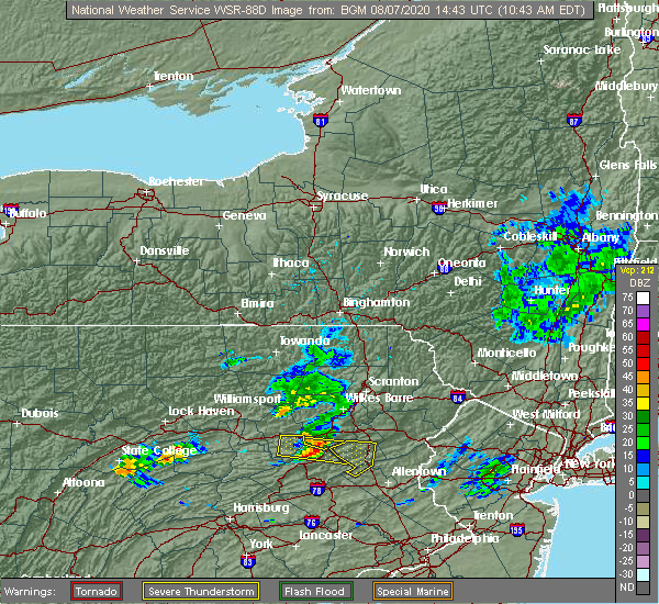
| 8/7/2020 11:28 AM EDT |
 The severe thunderstorm warning for northwestern lehigh and southern carbon counties will expire at 1130 am edt, the storm which prompted the warning has weakened below severe limits, and no longer poses an immediate threat to life or property. therefore, the warning will be allowed to expire. however gusty winds are still possible with this thunderstorm. The severe thunderstorm warning for northwestern lehigh and southern carbon counties will expire at 1130 am edt, the storm which prompted the warning has weakened below severe limits, and no longer poses an immediate threat to life or property. therefore, the warning will be allowed to expire. however gusty winds are still possible with this thunderstorm.
|
| 8/7/2020 11:12 AM EDT |
 The severe thunderstorm warning for south central luzerne county will expire at 1115 am edt, the storm which prompted the warning has moved out of the area. therefore, the warning will be allowed to expire. The severe thunderstorm warning for south central luzerne county will expire at 1115 am edt, the storm which prompted the warning has moved out of the area. therefore, the warning will be allowed to expire.
|
| 8/7/2020 11:01 AM EDT |
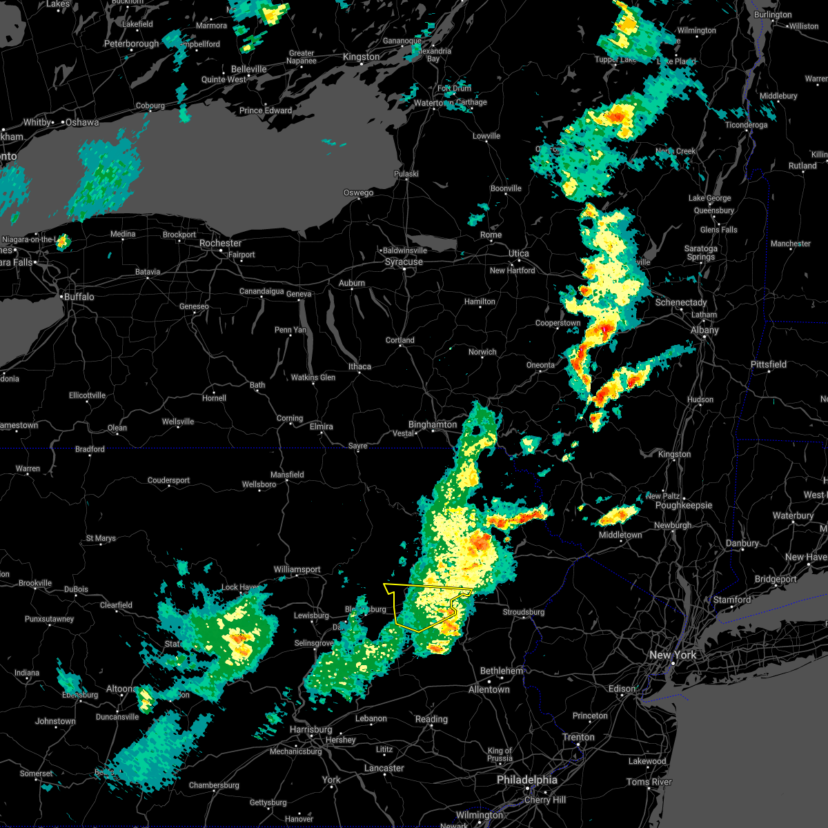
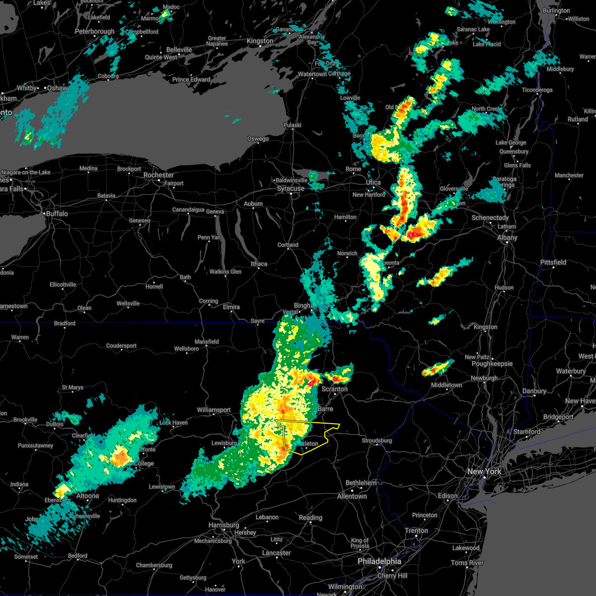
 At 1059 am edt, a severe thunderstorm was located over mcadoo, or near hazleton, moving east at 25 mph (radar indicated). Hazards include 60 mph wind gusts and penny size hail. Damage to roofs, siding, trees, and power lines is possible. locations impacted include, lehighton, palmerton, jim thorpe, slatington, nesquehoning, weatherly, new mahoning, beltzville state park, jordan valley, lansford, summit hill, bowmanstown, beaver meadows, parryville, weissport, weissport east and tresckow. This includes northeast extension between mile markers 69 and 85. At 1059 am edt, a severe thunderstorm was located over mcadoo, or near hazleton, moving east at 25 mph (radar indicated). Hazards include 60 mph wind gusts and penny size hail. Damage to roofs, siding, trees, and power lines is possible. locations impacted include, lehighton, palmerton, jim thorpe, slatington, nesquehoning, weatherly, new mahoning, beltzville state park, jordan valley, lansford, summit hill, bowmanstown, beaver meadows, parryville, weissport, weissport east and tresckow. This includes northeast extension between mile markers 69 and 85.
|
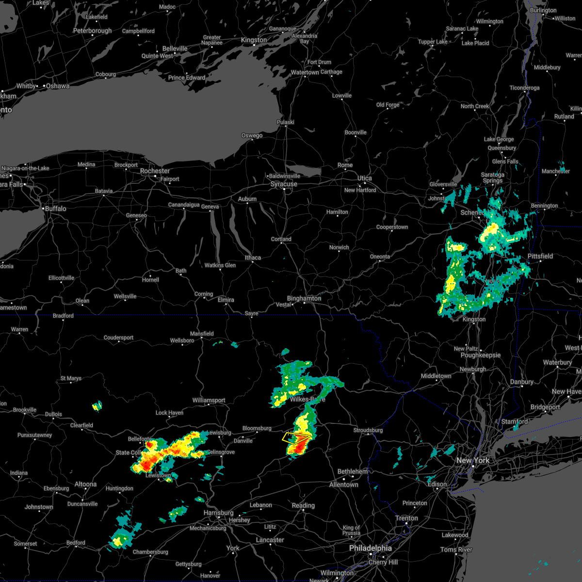
| 8/7/2020 10:45 AM EDT |
 At 1045 am edt, a severe thunderstorm was located over west hazleton, or near hazleton, moving east at 25 mph (radar indicated). Hazards include 60 mph wind gusts. Expect damage to roofs, siding, and trees. Locations impacted include, hazleton, west hazleton, conyngham, weston, ashmore, deringer, jeanesville and stockton. At 1045 am edt, a severe thunderstorm was located over west hazleton, or near hazleton, moving east at 25 mph (radar indicated). Hazards include 60 mph wind gusts. Expect damage to roofs, siding, and trees. Locations impacted include, hazleton, west hazleton, conyngham, weston, ashmore, deringer, jeanesville and stockton.
|
| 8/7/2020 10:34 AM EDT |
 At 1033 am edt, a severe thunderstorm was located over sheppton, or near mahanoy city, moving east at 30 mph (radar indicated). Hazards include 60 mph wind gusts and penny size hail. damage to roofs, siding, trees, and power lines is possible At 1033 am edt, a severe thunderstorm was located over sheppton, or near mahanoy city, moving east at 30 mph (radar indicated). Hazards include 60 mph wind gusts and penny size hail. damage to roofs, siding, trees, and power lines is possible
|
| 8/7/2020 10:16 AM EDT |
 At 1015 am edt, a severe thunderstorm was located over shumans, or 8 miles south of berwick, moving east at 25 mph (radar indicated). Hazards include 60 mph wind gusts and quarter size hail. Hail damage to vehicles is expected. Expect wind damage to roofs, siding, and trees. At 1015 am edt, a severe thunderstorm was located over shumans, or 8 miles south of berwick, moving east at 25 mph (radar indicated). Hazards include 60 mph wind gusts and quarter size hail. Hail damage to vehicles is expected. Expect wind damage to roofs, siding, and trees.
|
| 7/6/2020 5:29 PM EDT |
 At 529 pm edt, severe thunderstorms were located along a line extending from slatington to near new mahoning to near mcadoo, and are nearly stationary (radar indicated). Hazards include 60 mph wind gusts and quarter size hail. Minor damage to vehicles is possible. wind damage to roofs, siding, trees, and power lines is possible. locations impacted include, lehighton, palmerton, jim thorpe, slatington, nesquehoning, walnutport, danielsville, new mahoning, wanamakers, new tripoli, berlinsville, jordan valley, emerald, lansford, summit hill, bowmanstown, parryville, weissport, weissport east and tresckow. this includes the following highways, northeast extension between mile markers 66 and 77. Interstate 78 in pennsylvania between mile markers 40 and 43. At 529 pm edt, severe thunderstorms were located along a line extending from slatington to near new mahoning to near mcadoo, and are nearly stationary (radar indicated). Hazards include 60 mph wind gusts and quarter size hail. Minor damage to vehicles is possible. wind damage to roofs, siding, trees, and power lines is possible. locations impacted include, lehighton, palmerton, jim thorpe, slatington, nesquehoning, walnutport, danielsville, new mahoning, wanamakers, new tripoli, berlinsville, jordan valley, emerald, lansford, summit hill, bowmanstown, parryville, weissport, weissport east and tresckow. this includes the following highways, northeast extension between mile markers 66 and 77. Interstate 78 in pennsylvania between mile markers 40 and 43.
|
| 7/6/2020 5:00 PM EDT |
 At 459 pm edt, severe thunderstorms were located along a line extending from near jim thorpe to snyders, moving southeast at 5 mph (radar indicated). Hazards include 60 mph wind gusts and quarter size hail. Minor damage to vehicles is possible. Wind damage to roofs, siding, trees, and power lines is possible. At 459 pm edt, severe thunderstorms were located along a line extending from near jim thorpe to snyders, moving southeast at 5 mph (radar indicated). Hazards include 60 mph wind gusts and quarter size hail. Minor damage to vehicles is possible. Wind damage to roofs, siding, trees, and power lines is possible.
|
| 6/3/2020 11:04 AM EDT |
 At 1103 am edt, severe thunderstorms were located along a line extending from nuremburg to near friedensburg to fort indiantown gap, moving east at 75 mph (radar indicated). Hazards include 60 mph wind gusts and penny size hail. damage to roofs, siding, trees, and power lines is possible At 1103 am edt, severe thunderstorms were located along a line extending from nuremburg to near friedensburg to fort indiantown gap, moving east at 75 mph (radar indicated). Hazards include 60 mph wind gusts and penny size hail. damage to roofs, siding, trees, and power lines is possible
|
| 10/31/2019 9:26 PM EDT |
 At 926 pm edt, severe thunderstorms were located along a line extending from near skytop to akron, moving northeast at 50 mph (radar indicated). Hazards include 60 mph wind gusts. Damage to roofs, siding, trees, and power lines is possible. locations impacted include, reading, lehighton, mount pocono, wyomissing, northampton, east stroudsburg, tobyhanna, palmerton, kutztown, jim thorpe, hamburg, slatington, fleetwood, sinking spring, laureldale, nesquehoning, womelsdorf, weatherly, wernersville and newmanstown. this includes the following highways, interstate 80 in pennsylvania between mile markers 277 and 310. Interstate 78 in pennsylvania between mile markers 10 and 53. At 926 pm edt, severe thunderstorms were located along a line extending from near skytop to akron, moving northeast at 50 mph (radar indicated). Hazards include 60 mph wind gusts. Damage to roofs, siding, trees, and power lines is possible. locations impacted include, reading, lehighton, mount pocono, wyomissing, northampton, east stroudsburg, tobyhanna, palmerton, kutztown, jim thorpe, hamburg, slatington, fleetwood, sinking spring, laureldale, nesquehoning, womelsdorf, weatherly, wernersville and newmanstown. this includes the following highways, interstate 80 in pennsylvania between mile markers 277 and 310. Interstate 78 in pennsylvania between mile markers 10 and 53.
|
| 10/31/2019 8:58 PM EDT |
 At 857 pm edt, severe thunderstorms were located along a line extending from albrightsville to windsor, moving northeast at 50 mph (radar indicated). Hazards include 60 mph wind gusts. damage to roofs, siding, trees, and power lines is possible At 857 pm edt, severe thunderstorms were located along a line extending from albrightsville to windsor, moving northeast at 50 mph (radar indicated). Hazards include 60 mph wind gusts. damage to roofs, siding, trees, and power lines is possible
|
| 10/31/2019 8:39 PM EDT |
 At 838 pm edt, severe thunderstorms were located along a line extending from near hometown to manchester, moving northeast at 50 mph (radar indicated). Hazards include 60 mph wind gusts. Damage to roofs, siding, trees, and power lines is possible. locations impacted include, lehighton, jim thorpe, hamburg, nesquehoning, womelsdorf, weatherly, newmanstown, bernville, strausstown, new mahoning, wanamakers, lake harmony, penn forest reservoir, albrightsville, christmans, meckesville, lansford, summit hill, beaver meadows and parryville. this includes the following highways, interstate 80 in pennsylvania between mile markers 277 and 285. Interstate 78 in pennsylvania between mile markers 10 and 35. At 838 pm edt, severe thunderstorms were located along a line extending from near hometown to manchester, moving northeast at 50 mph (radar indicated). Hazards include 60 mph wind gusts. Damage to roofs, siding, trees, and power lines is possible. locations impacted include, lehighton, jim thorpe, hamburg, nesquehoning, womelsdorf, weatherly, newmanstown, bernville, strausstown, new mahoning, wanamakers, lake harmony, penn forest reservoir, albrightsville, christmans, meckesville, lansford, summit hill, beaver meadows and parryville. this includes the following highways, interstate 80 in pennsylvania between mile markers 277 and 285. Interstate 78 in pennsylvania between mile markers 10 and 35.
|
| 10/31/2019 8:33 PM EDT |
 At 832 pm edt, a severe thunderstorm was located over drifton, or over hazleton, moving northeast at 65 mph (radar indicated). Hazards include 60 mph wind gusts. expect damage to roofs, siding, and trees At 832 pm edt, a severe thunderstorm was located over drifton, or over hazleton, moving northeast at 65 mph (radar indicated). Hazards include 60 mph wind gusts. expect damage to roofs, siding, and trees
|
| 10/31/2019 8:11 PM EDT |
 At 811 pm edt, severe thunderstorms were located along a line extending from branchdale to new oxford, moving northeast at 50 mph (radar indicated). Hazards include 60 mph wind gusts. damage to roofs, siding, trees, and power lines is possible At 811 pm edt, severe thunderstorms were located along a line extending from branchdale to new oxford, moving northeast at 50 mph (radar indicated). Hazards include 60 mph wind gusts. damage to roofs, siding, trees, and power lines is possible
|
| 8/22/2019 6:01 PM EDT |
 At 601 pm edt, a severe thunderstorm was located near nesquehoning, or near hazleton, moving east at 40 mph (radar indicated). Hazards include 60 mph wind gusts and penny size hail. damage to roofs, siding, trees, and power lines is possible At 601 pm edt, a severe thunderstorm was located near nesquehoning, or near hazleton, moving east at 40 mph (radar indicated). Hazards include 60 mph wind gusts and penny size hail. damage to roofs, siding, trees, and power lines is possible
|
| 8/17/2019 8:23 PM EDT |
 At 822 pm edt, severe thunderstorms were located along a line extending from wilkes-barre to near slocum to beach haven, moving southeast at 35 mph (radar indicated). Hazards include 60 mph wind gusts and quarter size hail. Hail damage to vehicles is expected. expect wind damage to roofs, siding, and trees. Locations impacted include, wilkes-barre, hazleton, kingston, nanticoke, plymouth, edwardsville, west hazleton, larksville, forty fort and freeland. At 822 pm edt, severe thunderstorms were located along a line extending from wilkes-barre to near slocum to beach haven, moving southeast at 35 mph (radar indicated). Hazards include 60 mph wind gusts and quarter size hail. Hail damage to vehicles is expected. expect wind damage to roofs, siding, and trees. Locations impacted include, wilkes-barre, hazleton, kingston, nanticoke, plymouth, edwardsville, west hazleton, larksville, forty fort and freeland.
|
| 8/17/2019 8:10 PM EDT |
 At 809 pm edt, severe thunderstorms were located along a line extending from near muhlenberg to near shickshinny to near east berwick, moving east at 30 mph (radar indicated). Hazards include 60 mph wind gusts and quarter size hail. Hail damage to vehicles is expected. expect wind damage to roofs, siding, and trees. Locations impacted include, wilkes-barre, hazleton, muhlenberg, kingston, nanticoke, plains, plymouth, edwardsville, west hazleton and larksville. At 809 pm edt, severe thunderstorms were located along a line extending from near muhlenberg to near shickshinny to near east berwick, moving east at 30 mph (radar indicated). Hazards include 60 mph wind gusts and quarter size hail. Hail damage to vehicles is expected. expect wind damage to roofs, siding, and trees. Locations impacted include, wilkes-barre, hazleton, muhlenberg, kingston, nanticoke, plains, plymouth, edwardsville, west hazleton and larksville.
|
| 8/17/2019 7:51 PM EDT |
 The national weather service in binghamton has issued a * severe thunderstorm warning for. luzerne county in northeastern pennsylvania. until 830 pm edt. At 750 pm edt, severe thunderstorms were located along a line extending from near sweet valley to near fairmount springs to near. The national weather service in binghamton has issued a * severe thunderstorm warning for. luzerne county in northeastern pennsylvania. until 830 pm edt. At 750 pm edt, severe thunderstorms were located along a line extending from near sweet valley to near fairmount springs to near.
|
| 7/22/2019 12:42 AM EDT |
 The severe thunderstorm warning for carbon and southwestern monroe counties will expire at 1245 am edt, the storm which prompted the warning has weakened below severe limits, and no longer poses an immediate threat to life or property. therefore, the warning will be allowed to expire. however small hail, gusty winds and heavy rain are still possible with this thunderstorm. The severe thunderstorm warning for carbon and southwestern monroe counties will expire at 1245 am edt, the storm which prompted the warning has weakened below severe limits, and no longer poses an immediate threat to life or property. therefore, the warning will be allowed to expire. however small hail, gusty winds and heavy rain are still possible with this thunderstorm.
|
| 7/22/2019 12:05 AM EDT |
 At 1205 am edt, a severe thunderstorm was located near new mahoning, or near tamaqua, moving northeast at 30 mph (radar indicated). Hazards include 60 mph wind gusts and quarter size hail. Minor damage to vehicles is possible. Wind damage to roofs, siding, trees, and power lines is possible. At 1205 am edt, a severe thunderstorm was located near new mahoning, or near tamaqua, moving northeast at 30 mph (radar indicated). Hazards include 60 mph wind gusts and quarter size hail. Minor damage to vehicles is possible. Wind damage to roofs, siding, trees, and power lines is possible.
|
| 5/29/2019 4:43 PM EDT |
 At 442 pm edt, severe thunderstorms were located along a line extending from glendale to near white haven to hazleton, moving east at 55 mph (radar indicated). Hazards include 60 mph wind gusts and quarter size hail. Hail damage to vehicles is expected. expect wind damage to roofs, siding, and trees. Locations impacted include, scranton, wilkes-barre, hazleton, dunmore, kingston, plains, old forge, pittston, taylor and moosic. At 442 pm edt, severe thunderstorms were located along a line extending from glendale to near white haven to hazleton, moving east at 55 mph (radar indicated). Hazards include 60 mph wind gusts and quarter size hail. Hail damage to vehicles is expected. expect wind damage to roofs, siding, and trees. Locations impacted include, scranton, wilkes-barre, hazleton, dunmore, kingston, plains, old forge, pittston, taylor and moosic.
|
| 5/29/2019 4:42 PM EDT |
 At 441 pm edt, a severe thunderstorm was located near white haven, or 11 miles north of lehighton, moving east at 30 mph (radar indicated). Hazards include 60 mph wind gusts and penny size hail. damage to roofs, siding, trees, and power lines is possible At 441 pm edt, a severe thunderstorm was located near white haven, or 11 miles north of lehighton, moving east at 30 mph (radar indicated). Hazards include 60 mph wind gusts and penny size hail. damage to roofs, siding, trees, and power lines is possible
|
| 5/29/2019 4:18 PM EDT |
 At 418 pm edt, severe thunderstorms were located along a line extending from near sweet valley to near beach haven to near mainville, moving east at 55 mph (radar indicated). Hazards include 60 mph wind gusts and quarter size hail. Hail damage to vehicles is expected. Expect wind damage to roofs, siding, and trees. At 418 pm edt, severe thunderstorms were located along a line extending from near sweet valley to near beach haven to near mainville, moving east at 55 mph (radar indicated). Hazards include 60 mph wind gusts and quarter size hail. Hail damage to vehicles is expected. Expect wind damage to roofs, siding, and trees.
|
| 5/29/2019 4:12 PM EDT |
 The severe thunderstorm warning for carbon, southwestern monroe and west central northampton counties will expire at 415 pm edt, the storm which prompted the warning has weakened below severe limits, and has exited the warned area. therefore, the warning will be allowed to expire. a tornado watch remains in effect until 800 pm edt for eastern and northeastern pennsylvania. remember, a severe thunderstorm warning still remains in effect for portions of carbon, northampton, and monroe counties. The severe thunderstorm warning for carbon, southwestern monroe and west central northampton counties will expire at 415 pm edt, the storm which prompted the warning has weakened below severe limits, and has exited the warned area. therefore, the warning will be allowed to expire. a tornado watch remains in effect until 800 pm edt for eastern and northeastern pennsylvania. remember, a severe thunderstorm warning still remains in effect for portions of carbon, northampton, and monroe counties.
|
| 5/29/2019 3:55 PM EDT |
 At 355 pm edt, a severe thunderstorm was located over drifton, or near hazleton, moving east at 45 mph (radar indicated). Hazards include 70 mph wind gusts and ping pong ball size hail. People and animals outdoors will be injured. expect hail damage to roofs, siding, windows, and vehicles. expect considerable tree damage. wind damage is also likely to mobile homes, roofs, and outbuildings. Locations impacted include, hazleton, west hazleton, freeland, white haven, jeddo, woodside-drifton, drifton, ashmore, jeanesville and stockton. At 355 pm edt, a severe thunderstorm was located over drifton, or near hazleton, moving east at 45 mph (radar indicated). Hazards include 70 mph wind gusts and ping pong ball size hail. People and animals outdoors will be injured. expect hail damage to roofs, siding, windows, and vehicles. expect considerable tree damage. wind damage is also likely to mobile homes, roofs, and outbuildings. Locations impacted include, hazleton, west hazleton, freeland, white haven, jeddo, woodside-drifton, drifton, ashmore, jeanesville and stockton.
|
| 5/29/2019 3:32 PM EDT |
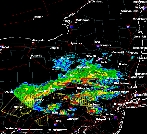 At 332 pm edt, a severe thunderstorm was located near rock glen, or near berwick, moving east at 45 mph (radar indicated). Hazards include 70 mph wind gusts and ping pong ball size hail. People and animals outdoors will be injured. expect hail damage to roofs, siding, windows, and vehicles. expect considerable tree damage. Wind damage is also likely to mobile homes, roofs, and outbuildings. At 332 pm edt, a severe thunderstorm was located near rock glen, or near berwick, moving east at 45 mph (radar indicated). Hazards include 70 mph wind gusts and ping pong ball size hail. People and animals outdoors will be injured. expect hail damage to roofs, siding, windows, and vehicles. expect considerable tree damage. Wind damage is also likely to mobile homes, roofs, and outbuildings.
|
| 5/29/2019 3:29 PM EDT |
 At 328 pm edt, a severe thunderstorm was located near woodside-drifton, or 7 miles northeast of hazleton, moving east at 35 mph (radar indicated). Hazards include 70 mph wind gusts and quarter size hail. Minor damage to vehicles is possible. expect considerable tree damage. Wind damage is also likely to mobile homes, roofs, and outbuildings. At 328 pm edt, a severe thunderstorm was located near woodside-drifton, or 7 miles northeast of hazleton, moving east at 35 mph (radar indicated). Hazards include 70 mph wind gusts and quarter size hail. Minor damage to vehicles is possible. expect considerable tree damage. Wind damage is also likely to mobile homes, roofs, and outbuildings.
|
| 5/19/2019 11:00 PM EDT |
 At 1100 pm edt, a severe thunderstorm was located over hamburg, or 10 miles east of schuylkill haven, moving east at 45 mph (radar indicated). Hazards include 60 mph wind gusts and quarter size hail. Minor damage to vehicles is possible. Wind damage to roofs, siding, trees, and power lines is possible. At 1100 pm edt, a severe thunderstorm was located over hamburg, or 10 miles east of schuylkill haven, moving east at 45 mph (radar indicated). Hazards include 60 mph wind gusts and quarter size hail. Minor damage to vehicles is possible. Wind damage to roofs, siding, trees, and power lines is possible.
|
| 5/19/2019 8:03 PM EDT |
 At 802 pm edt, severe thunderstorms were located along a line extending from near fairmount spgs to near mcadoo, moving east at 50 mph (radar indicated). Hazards include 70 mph wind gusts and quarter size hail. Hail damage to vehicles is expected. expect considerable tree damage. wind damage is also likely to mobile homes, roofs, and outbuildings. Locations impacted include, wilkes-barre, hazleton, muhlenberg, kingston, berwick, nanticoke, plains, plymouth, swoyersville and edwardsville. At 802 pm edt, severe thunderstorms were located along a line extending from near fairmount spgs to near mcadoo, moving east at 50 mph (radar indicated). Hazards include 70 mph wind gusts and quarter size hail. Hail damage to vehicles is expected. expect considerable tree damage. wind damage is also likely to mobile homes, roofs, and outbuildings. Locations impacted include, wilkes-barre, hazleton, muhlenberg, kingston, berwick, nanticoke, plains, plymouth, swoyersville and edwardsville.
|
| 5/19/2019 7:43 PM EDT |
 At 742 pm edt, severe thunderstorms were located along a line extending from lairdsville to near shumans, moving east at 50 mph (radar indicated). Hazards include 60 mph wind gusts and quarter size hail. Hail damage to vehicles is expected. Expect wind damage to roofs, siding, and trees. At 742 pm edt, severe thunderstorms were located along a line extending from lairdsville to near shumans, moving east at 50 mph (radar indicated). Hazards include 60 mph wind gusts and quarter size hail. Hail damage to vehicles is expected. Expect wind damage to roofs, siding, and trees.
|
| 5/19/2019 6:40 PM EDT |
 At 636 pm edt, a severe thunderstorm was located over weatherly, or near lehighton, moving northeast at 45 mph (radar indicated). Hazards include 60 mph wind gusts and quarter size hail. Minor damage to vehicles is possible. wind damage to roofs, siding, trees, and power lines is possible. Locations impacted include, lehighton, palmerton, jim thorpe, nesquehoning, weatherly, new mahoning, beltzville state park, penn forest reservoir, christmans, lansford, summit hill, bowmanstown, beaver meadows, parryville, weissport, trachsville, weissport east and tresckow. At 636 pm edt, a severe thunderstorm was located over weatherly, or near lehighton, moving northeast at 45 mph (radar indicated). Hazards include 60 mph wind gusts and quarter size hail. Minor damage to vehicles is possible. wind damage to roofs, siding, trees, and power lines is possible. Locations impacted include, lehighton, palmerton, jim thorpe, nesquehoning, weatherly, new mahoning, beltzville state park, penn forest reservoir, christmans, lansford, summit hill, bowmanstown, beaver meadows, parryville, weissport, trachsville, weissport east and tresckow.
|
| 5/19/2019 6:38 PM EDT |
 At 636 pm edt, severe thunderstorms were located along a line extending from near sweet valley to sugar notch to near white haven to near weatherly, moving northeast at 45 mph. damage has previously been reported with this line of severe thunderstorms (trained weather spotters). Hazards include 70 mph wind gusts and quarter size hail. Hail damage to vehicles is expected. expect considerable tree damage. wind damage is also likely to mobile homes, roofs, and outbuildings. locations impacted include, scranton, wilkes-barre, falls, hazleton, muhlenberg, dunmore, kingston, nanticoke, plains and carbondale. This storm will impact motorists on interstate 81 between hazleton and the wilkes-barre/scranton area. At 636 pm edt, severe thunderstorms were located along a line extending from near sweet valley to sugar notch to near white haven to near weatherly, moving northeast at 45 mph. damage has previously been reported with this line of severe thunderstorms (trained weather spotters). Hazards include 70 mph wind gusts and quarter size hail. Hail damage to vehicles is expected. expect considerable tree damage. wind damage is also likely to mobile homes, roofs, and outbuildings. locations impacted include, scranton, wilkes-barre, falls, hazleton, muhlenberg, dunmore, kingston, nanticoke, plains and carbondale. This storm will impact motorists on interstate 81 between hazleton and the wilkes-barre/scranton area.
|
| 5/19/2019 6:28 PM EDT |
 At 627 pm edt, severe thunderstorms were located along a line extending from near muhlenberg to slocum to drifton to nesquehoning, moving east at 35 mph (trained weather spotters. at 625 pm, trees were reported blown down in hollenback and salem townships). Hazards include 70 mph wind gusts and quarter size hail. Hail damage to vehicles is expected. expect considerable tree damage. wind damage is also likely to mobile homes, roofs, and outbuildings. Locations impacted include, scranton, wilkes-barre, falls, hazleton, muhlenberg, dunmore, kingston, nanticoke, plains and carbondale. At 627 pm edt, severe thunderstorms were located along a line extending from near muhlenberg to slocum to drifton to nesquehoning, moving east at 35 mph (trained weather spotters. at 625 pm, trees were reported blown down in hollenback and salem townships). Hazards include 70 mph wind gusts and quarter size hail. Hail damage to vehicles is expected. expect considerable tree damage. wind damage is also likely to mobile homes, roofs, and outbuildings. Locations impacted include, scranton, wilkes-barre, falls, hazleton, muhlenberg, dunmore, kingston, nanticoke, plains and carbondale.
|
| 5/19/2019 6:20 PM EDT |
 At 619 pm edt, a severe thunderstorm was located over tamaqua, moving northeast at 30 mph (radar indicated). Hazards include 60 mph wind gusts and quarter size hail. Minor damage to vehicles is possible. Wind damage to roofs, siding, trees, and power lines is possible. At 619 pm edt, a severe thunderstorm was located over tamaqua, moving northeast at 30 mph (radar indicated). Hazards include 60 mph wind gusts and quarter size hail. Minor damage to vehicles is possible. Wind damage to roofs, siding, trees, and power lines is possible.
|
| 5/19/2019 6:09 PM EDT |
 At 608 pm edt, severe thunderstorms were located along a line extending from near rohrsburg to near nescopeck to grier city-park crest to near friedensburg, moving northeast at 45 mph (radar indicated). Hazards include 60 mph wind gusts and quarter size hail. Hail damage to vehicles is expected. Expect wind damage to roofs, siding, and trees. At 608 pm edt, severe thunderstorms were located along a line extending from near rohrsburg to near nescopeck to grier city-park crest to near friedensburg, moving northeast at 45 mph (radar indicated). Hazards include 60 mph wind gusts and quarter size hail. Hail damage to vehicles is expected. Expect wind damage to roofs, siding, and trees.
|
| 4/15/2019 1:41 AM EDT |
 At 140 am edt, severe thunderstorms were located along a line extending from great bend to la plume to near bear creek, moving northeast at 70 mph (radar indicated). Hazards include 70 mph wind gusts and nickel size hail. Expect considerable tree damage. damage is likely to mobile homes, roofs, and outbuildings. Locations impacted include, scranton, wilkes-barre, falls, hazleton, dunmore, kingston, nanticoke, plains, old forge and pittston. At 140 am edt, severe thunderstorms were located along a line extending from great bend to la plume to near bear creek, moving northeast at 70 mph (radar indicated). Hazards include 70 mph wind gusts and nickel size hail. Expect considerable tree damage. damage is likely to mobile homes, roofs, and outbuildings. Locations impacted include, scranton, wilkes-barre, falls, hazleton, dunmore, kingston, nanticoke, plains, old forge and pittston.
|
| 4/15/2019 1:28 AM EDT |
 At 127 am edt, severe thunderstorms were located along a line extending from near sweet valley to near slocum to near shenandoah, moving northeast at 65 mph (radar indicated). Hazards include 60 mph wind gusts. damage to roofs, siding, trees, and power lines is possible At 127 am edt, severe thunderstorms were located along a line extending from near sweet valley to near slocum to near shenandoah, moving northeast at 65 mph (radar indicated). Hazards include 60 mph wind gusts. damage to roofs, siding, trees, and power lines is possible
|
| 4/15/2019 1:03 AM EDT |
 At 102 am edt, severe thunderstorms were located along a line extending from monroeton to near biggertown to near knoebels grove, moving northeast at 70 mph (radar indicated). Hazards include 70 mph wind gusts and nickel size hail. Expect considerable tree damage. Damage is likely to mobile homes, roofs, and outbuildings. At 102 am edt, severe thunderstorms were located along a line extending from monroeton to near biggertown to near knoebels grove, moving northeast at 70 mph (radar indicated). Hazards include 70 mph wind gusts and nickel size hail. Expect considerable tree damage. Damage is likely to mobile homes, roofs, and outbuildings.
|
| 6/18/2018 6:10 PM EDT |
 At 609 pm edt, severe thunderstorms were located along a line extending from gouldsboro state park to near hometown, moving east at 35 mph (radar indicated). Hazards include 60 mph wind gusts. damage to roofs, siding, trees, and power lines is possible At 609 pm edt, severe thunderstorms were located along a line extending from gouldsboro state park to near hometown, moving east at 35 mph (radar indicated). Hazards include 60 mph wind gusts. damage to roofs, siding, trees, and power lines is possible
|
| 6/18/2018 5:27 PM EDT |
 At 527 pm edt, severe thunderstorms were located along a line extending from near bethany to near mount cobb to near bear creek village to near shickshinny, moving east southeast at 40 mph (radar indicated). Hazards include 60 mph wind gusts. Expect damage to roofs, siding, and trees. severe thunderstorms will be near, honesdale, prompton and bethany around 530 pm edt. moscow, arlington and ledgerdale around 535 pm edt. blooming grove, paupack and sterling around 540 pm edt. white haven, greeley and angels around 545 pm edt. stoddartsville around 550 pm edt. montague, milford and pecks pond around 555 pm edt. port jervis around 600 pm edt. Dingmans ferry around 605 pm edt. At 527 pm edt, severe thunderstorms were located along a line extending from near bethany to near mount cobb to near bear creek village to near shickshinny, moving east southeast at 40 mph (radar indicated). Hazards include 60 mph wind gusts. Expect damage to roofs, siding, and trees. severe thunderstorms will be near, honesdale, prompton and bethany around 530 pm edt. moscow, arlington and ledgerdale around 535 pm edt. blooming grove, paupack and sterling around 540 pm edt. white haven, greeley and angels around 545 pm edt. stoddartsville around 550 pm edt. montague, milford and pecks pond around 555 pm edt. port jervis around 600 pm edt. Dingmans ferry around 605 pm edt.
|
| 5/15/2018 3:53 PM EDT |
 At 352 pm edt, severe thunderstorms were located along a line extending from near pecks pond to near palmerton, moving east at 60 mph (radar indicated). Hazards include 70 mph wind gusts and quarter size hail. Minor damage to vehicles is possible. expect considerable tree damage. wind damage is also likely to mobile homes, roofs, and outbuildings. Locations impacted include, lehighton, mount pocono, east stroudsburg, tobyhanna, palmerton, jim thorpe, nesquehoning, wind gap, weatherly, stormville, werry lake, pocono pines, lake harmony, skytop, tannersville, long pond, kresgeville, sun valley, reeders and beltzville state park. At 352 pm edt, severe thunderstorms were located along a line extending from near pecks pond to near palmerton, moving east at 60 mph (radar indicated). Hazards include 70 mph wind gusts and quarter size hail. Minor damage to vehicles is possible. expect considerable tree damage. wind damage is also likely to mobile homes, roofs, and outbuildings. Locations impacted include, lehighton, mount pocono, east stroudsburg, tobyhanna, palmerton, jim thorpe, nesquehoning, wind gap, weatherly, stormville, werry lake, pocono pines, lake harmony, skytop, tannersville, long pond, kresgeville, sun valley, reeders and beltzville state park.
|
| 5/15/2018 3:37 PM EDT |
 At 334 pm edt, severe thunderstorms were located along a line extending from white sulphur springs to near bethel to near sterling to mcadoo, moving east at 55 mph. several damage reports, associated with this line of thunderstorms, have been received at the national weather service in binghamton. a wind gust between 60 and 65 miles per hour was reported as the line passed over the wilkes- barre/scranton airport (trained weather spotters). Hazards include 70 mph wind gusts and quarter size hail. Hail damage to vehicles is expected. expect considerable tree damage. wind damage is also likely to mobile homes, roofs, and outbuildings. locations impacted include, scranton, wilkes-barre, hazleton, dunmore, kingston, fallsburg, nanticoke, plains, carbondale and port jervis. A tornado watch remains in effect until 800 pm edt for central new york, and northeastern pennsylvania. At 334 pm edt, severe thunderstorms were located along a line extending from white sulphur springs to near bethel to near sterling to mcadoo, moving east at 55 mph. several damage reports, associated with this line of thunderstorms, have been received at the national weather service in binghamton. a wind gust between 60 and 65 miles per hour was reported as the line passed over the wilkes- barre/scranton airport (trained weather spotters). Hazards include 70 mph wind gusts and quarter size hail. Hail damage to vehicles is expected. expect considerable tree damage. wind damage is also likely to mobile homes, roofs, and outbuildings. locations impacted include, scranton, wilkes-barre, hazleton, dunmore, kingston, fallsburg, nanticoke, plains, carbondale and port jervis. A tornado watch remains in effect until 800 pm edt for central new york, and northeastern pennsylvania.
|
| 5/15/2018 3:33 PM EDT |
 At 332 pm edt, severe thunderstorms were located along a line extending from white sulphur springs to near bethel to near sterling to mcadoo, moving east at 55 mph (radar indicated). Hazards include 70 mph wind gusts and quarter size hail. Hail damage to vehicles is expected. expect considerable tree damage. wind damage is also likely to mobile homes, roofs, and outbuildings. locations impacted include, scranton, wilkes-barre, hazleton, dunmore, kingston, fallsburg, nanticoke, plains, carbondale and port jervis. A tornado watch remains in effect until 800 pm edt for central new york, and northeastern pennsylvania. At 332 pm edt, severe thunderstorms were located along a line extending from white sulphur springs to near bethel to near sterling to mcadoo, moving east at 55 mph (radar indicated). Hazards include 70 mph wind gusts and quarter size hail. Hail damage to vehicles is expected. expect considerable tree damage. wind damage is also likely to mobile homes, roofs, and outbuildings. locations impacted include, scranton, wilkes-barre, hazleton, dunmore, kingston, fallsburg, nanticoke, plains, carbondale and port jervis. A tornado watch remains in effect until 800 pm edt for central new york, and northeastern pennsylvania.
|
| 5/15/2018 3:20 PM EDT |
 At 320 pm edt, severe thunderstorms were located along a line extending from near old forge to near shumans, moving east at 65 mph (radar indicated). Hazards include 70 mph wind gusts and quarter size hail. Minor damage to vehicles is possible. expect considerable tree damage. Wind damage is also likely to mobile homes, roofs, and outbuildings. At 320 pm edt, severe thunderstorms were located along a line extending from near old forge to near shumans, moving east at 65 mph (radar indicated). Hazards include 70 mph wind gusts and quarter size hail. Minor damage to vehicles is possible. expect considerable tree damage. Wind damage is also likely to mobile homes, roofs, and outbuildings.
|
| 5/15/2018 3:05 PM EDT |
 At 304 pm edt, severe thunderstorms were located along a line extending from stalker to near falls to rupert, moving east at 55 mph (radar indicated). Hazards include 70 mph wind gusts and quarter size hail. Hail damage to vehicles is expected. expect considerable tree damage. wind damage is also likely to mobile homes, roofs, and outbuildings. severe thunderstorms will be near, callicoon, hankins and stalker around 310 pm edt. scranton, dickson city and moosic around 315 pm edt. dunmore, olyphant and white sulphur springs around 320 pm edt. liberty, moscow and conyngham around 325 pm edt. hazleton, west hazleton and south fallsburg around 330 pm edt. fallsburg, sterling and woodridge around 335 pm edt. greentown around 340 pm edt. blooming grove and paupack around 345 pm edt. A tornado watch remains in effect until 800 pm edt for central new york, and northeastern pennsylvania. At 304 pm edt, severe thunderstorms were located along a line extending from stalker to near falls to rupert, moving east at 55 mph (radar indicated). Hazards include 70 mph wind gusts and quarter size hail. Hail damage to vehicles is expected. expect considerable tree damage. wind damage is also likely to mobile homes, roofs, and outbuildings. severe thunderstorms will be near, callicoon, hankins and stalker around 310 pm edt. scranton, dickson city and moosic around 315 pm edt. dunmore, olyphant and white sulphur springs around 320 pm edt. liberty, moscow and conyngham around 325 pm edt. hazleton, west hazleton and south fallsburg around 330 pm edt. fallsburg, sterling and woodridge around 335 pm edt. greentown around 340 pm edt. blooming grove and paupack around 345 pm edt. A tornado watch remains in effect until 800 pm edt for central new york, and northeastern pennsylvania.
|
| 5/10/2018 6:41 PM EDT |
 The severe thunderstorm warning for southeastern lackawanna, southwestern wayne and southeastern luzerne counties will expire at 645 pm edt, the storms which prompted the warning have moved out of the area or will so shortly. therefore, the warning will be allowed to expire. to report severe weather, contact your nearest law enforcement agency. they will relay your report to the national weather service binghamton. The severe thunderstorm warning for southeastern lackawanna, southwestern wayne and southeastern luzerne counties will expire at 645 pm edt, the storms which prompted the warning have moved out of the area or will so shortly. therefore, the warning will be allowed to expire. to report severe weather, contact your nearest law enforcement agency. they will relay your report to the national weather service binghamton.
|
| 5/10/2018 6:29 PM EDT |
 At 628 pm edt, severe thunderstorms were located along a line extending from near alpine mountain to near jim thorpe, moving southeast at 45 mph (radar indicated. at 5:50 pm nickel size hail was reported in lackawanna). Hazards include 60 mph wind gusts and quarter size hail. Hail damage to vehicles is expected. expect wind damage to roofs, siding, and trees. These severe thunderstorms will remain over mainly rural areas of southeastern lackawanna, southwestern wayne and southeastern luzerne counties. At 628 pm edt, severe thunderstorms were located along a line extending from near alpine mountain to near jim thorpe, moving southeast at 45 mph (radar indicated. at 5:50 pm nickel size hail was reported in lackawanna). Hazards include 60 mph wind gusts and quarter size hail. Hail damage to vehicles is expected. expect wind damage to roofs, siding, and trees. These severe thunderstorms will remain over mainly rural areas of southeastern lackawanna, southwestern wayne and southeastern luzerne counties.
|
| 5/10/2018 6:17 PM EDT |
 At 617 pm edt, severe thunderstorms were located along a line extending from bear creek village to near white haven to near hazleton, moving east at 35 mph (radar indicated). Hazards include 60 mph wind gusts and quarter size hail. Minor damage to vehicles is possible. Wind damage to roofs, siding, trees, and power lines is possible. At 617 pm edt, severe thunderstorms were located along a line extending from bear creek village to near white haven to near hazleton, moving east at 35 mph (radar indicated). Hazards include 60 mph wind gusts and quarter size hail. Minor damage to vehicles is possible. Wind damage to roofs, siding, trees, and power lines is possible.
|
| 5/10/2018 6:06 PM EDT |
 At 605 pm edt, severe thunderstorms were located along a line extending from lehigh to near drums, moving southeast at 45 mph (radar indicated. at 5:44 pm dime size hail was reported in duryea). Hazards include 60 mph wind gusts and quarter size hail. Hail damage to vehicles is expected. expect wind damage to roofs, siding, and trees. these severe storms will be near, sterling, lehigh and angels around 610 pm edt. White haven around 620 pm edt. At 605 pm edt, severe thunderstorms were located along a line extending from lehigh to near drums, moving southeast at 45 mph (radar indicated. at 5:44 pm dime size hail was reported in duryea). Hazards include 60 mph wind gusts and quarter size hail. Hail damage to vehicles is expected. expect wind damage to roofs, siding, and trees. these severe storms will be near, sterling, lehigh and angels around 610 pm edt. White haven around 620 pm edt.
|
| 5/10/2018 5:45 PM EDT |
 At 544 pm edt, severe thunderstorms were located along a line extending from scranton to near huntington mills, moving southeast at 45 mph (radar indicated). Hazards include 60 mph wind gusts and quarter size hail. Hail damage to vehicles is expected. expect wind damage to roofs, siding, and trees. severe thunderstorms will be near, scranton, dunmore and old forge around 550 pm edt. moscow around 555 pm edt. conyngham, sterling and lehigh around 605 pm edt. hazleton, west hazleton and angels around 610 pm edt. Freeland, drifton and woodside-drifton around 615 pm edt. At 544 pm edt, severe thunderstorms were located along a line extending from scranton to near huntington mills, moving southeast at 45 mph (radar indicated). Hazards include 60 mph wind gusts and quarter size hail. Hail damage to vehicles is expected. expect wind damage to roofs, siding, and trees. severe thunderstorms will be near, scranton, dunmore and old forge around 550 pm edt. moscow around 555 pm edt. conyngham, sterling and lehigh around 605 pm edt. hazleton, west hazleton and angels around 610 pm edt. Freeland, drifton and woodside-drifton around 615 pm edt.
|
| 9/5/2017 5:19 PM EDT |
 At 517 pm edt, severe thunderstorms were located along a line extending from claussville to near womelsdorf to near belvidere. storms are moving northeast along the line at around 30 mph (radar indicated). Hazards include 60 mph wind gusts and penny size hail. Expect damage to trees and power lines. Locations impacted include, allentown, reading, easton, lehighton, bethlehem, forks, wyomissing, northampton, wilson, nazareth, palmerton, bangor, kutztown, jim thorpe, hamburg, slatington, fleetwood, sinking spring, laureldale and pen argyl. At 517 pm edt, severe thunderstorms were located along a line extending from claussville to near womelsdorf to near belvidere. storms are moving northeast along the line at around 30 mph (radar indicated). Hazards include 60 mph wind gusts and penny size hail. Expect damage to trees and power lines. Locations impacted include, allentown, reading, easton, lehighton, bethlehem, forks, wyomissing, northampton, wilson, nazareth, palmerton, bangor, kutztown, jim thorpe, hamburg, slatington, fleetwood, sinking spring, laureldale and pen argyl.
|
| 9/5/2017 4:54 PM EDT |
 At 454 pm edt, severe thunderstorms were located along a line extending from near wernersville to near branchdale to near northampton, moving northeast at 30 mph (radar indicated). Hazards include 60 mph wind gusts and penny size hail. expect damage to trees and power lines At 454 pm edt, severe thunderstorms were located along a line extending from near wernersville to near branchdale to near northampton, moving northeast at 30 mph (radar indicated). Hazards include 60 mph wind gusts and penny size hail. expect damage to trees and power lines
|
| 8/22/2017 7:57 PM EDT |
 At 756 pm edt, a severe thunderstorm was located over mcadoo, or near hazleton, moving northeast at 35 mph (radar indicated). Hazards include 60 mph wind gusts and quarter size hail. Minor damage to vehicles is possible. Expect damage to trees and power lines. At 756 pm edt, a severe thunderstorm was located over mcadoo, or near hazleton, moving northeast at 35 mph (radar indicated). Hazards include 60 mph wind gusts and quarter size hail. Minor damage to vehicles is possible. Expect damage to trees and power lines.
|
| 7/20/2017 6:48 PM EDT |
 At 648 pm edt, severe thunderstorms were located along a line extending from saylorsburg to beersville to mcadoo, moving southeast at 35 mph (radar indicated). Hazards include 60 mph wind gusts. Expect damage to trees and power lines. these severe storms will be near, northampton, nazareth, pen argyl, wind gap, bath, saylorsburg, beersville and rossland around 655 pm edt. bethlehem, bangor, belfast and steuben around 700 pm edt. forks, wilson, west easton, tatamy, old orchard and lehigh university around 705 pm edt. easton, lehighton, harmony, glendon and roxburg around 710 pm edt. palmerton, slatington, alpha, walnutport, jordan valley, emerald, new tripoli and schnecksville around 715 pm edt. Other locations impacted by these severe thunderstorms include chapman, beaver meadows, coplay, fountain hill, fullerton, hokendauqua, stockertown, summit hill, bowmanstown and weissport. At 648 pm edt, severe thunderstorms were located along a line extending from saylorsburg to beersville to mcadoo, moving southeast at 35 mph (radar indicated). Hazards include 60 mph wind gusts. Expect damage to trees and power lines. these severe storms will be near, northampton, nazareth, pen argyl, wind gap, bath, saylorsburg, beersville and rossland around 655 pm edt. bethlehem, bangor, belfast and steuben around 700 pm edt. forks, wilson, west easton, tatamy, old orchard and lehigh university around 705 pm edt. easton, lehighton, harmony, glendon and roxburg around 710 pm edt. palmerton, slatington, alpha, walnutport, jordan valley, emerald, new tripoli and schnecksville around 715 pm edt. Other locations impacted by these severe thunderstorms include chapman, beaver meadows, coplay, fountain hill, fullerton, hokendauqua, stockertown, summit hill, bowmanstown and weissport.
|
| 7/20/2017 6:22 PM EDT |
 At 620 pm edt, severe thunderstorms were located along a line extending from albrightsville to drifton to near rock glen, moving southeast at 35 mph (radar indicated). Hazards include 60 mph wind gusts. Expect damage to trees and power lines. severe thunderstorms will be near, meckesville, albrightsville and christmans around 625 pm edt. weatherly, jonas, sun valley and penn forest reservoir around 630 pm edt. nesquehoning, kresgeville and mcmichael around 635 pm edt. jim thorpe, gilbert and brodheadsville around 640 pm edt. lehighton, rossland and kunkletown around 645 pm edt. saylorsburg and beltzville state park around 650 pm edt. palmerton, pen argyl and wind gap around 655 pm edt. nazareth, bangor, slatington, walnutport, belfast, berlinsville and emerald around 700 pm edt. Other locations impacted by these severe thunderstorms include effort, hokendauqua, stockertown, trachsville, weissport, parryville, eastlawn gardens, north catasauqua, freemansburg and merwinsburg. At 620 pm edt, severe thunderstorms were located along a line extending from albrightsville to drifton to near rock glen, moving southeast at 35 mph (radar indicated). Hazards include 60 mph wind gusts. Expect damage to trees and power lines. severe thunderstorms will be near, meckesville, albrightsville and christmans around 625 pm edt. weatherly, jonas, sun valley and penn forest reservoir around 630 pm edt. nesquehoning, kresgeville and mcmichael around 635 pm edt. jim thorpe, gilbert and brodheadsville around 640 pm edt. lehighton, rossland and kunkletown around 645 pm edt. saylorsburg and beltzville state park around 650 pm edt. palmerton, pen argyl and wind gap around 655 pm edt. nazareth, bangor, slatington, walnutport, belfast, berlinsville and emerald around 700 pm edt. Other locations impacted by these severe thunderstorms include effort, hokendauqua, stockertown, trachsville, weissport, parryville, eastlawn gardens, north catasauqua, freemansburg and merwinsburg.
|
| 7/20/2017 6:05 PM EDT |
 At 604 pm edt, severe thunderstorms were located along a line extending from near blakeslee to near drums to mifflinville, moving southeast at 35 mph (radar indicated). Hazards include 60 mph wind gusts and quarter size hail. Minor damage to vehicles is possible. expect damage to trees and power lines. these severe storms will be near, lake harmony and blakeslee around 610 pm edt. albrightsville and christmans around 615 pm edt. meckesville and penn forest reservoir around 620 pm edt. weatherly, sun valley and jonas around 625 pm edt. lehighton, jim thorpe, nesquehoning, brodheadsville, gilbert, kresgeville, rossland and saylorsburg around 630 pm edt. Other locations impacted by these severe thunderstorms include trachsville, weissport, fiddletown, parryville, beaver meadows, weissport east, merwinsburg, effort, tresckow and lansford. At 604 pm edt, severe thunderstorms were located along a line extending from near blakeslee to near drums to mifflinville, moving southeast at 35 mph (radar indicated). Hazards include 60 mph wind gusts and quarter size hail. Minor damage to vehicles is possible. expect damage to trees and power lines. these severe storms will be near, lake harmony and blakeslee around 610 pm edt. albrightsville and christmans around 615 pm edt. meckesville and penn forest reservoir around 620 pm edt. weatherly, sun valley and jonas around 625 pm edt. lehighton, jim thorpe, nesquehoning, brodheadsville, gilbert, kresgeville, rossland and saylorsburg around 630 pm edt. Other locations impacted by these severe thunderstorms include trachsville, weissport, fiddletown, parryville, beaver meadows, weissport east, merwinsburg, effort, tresckow and lansford.
|
| 7/20/2017 5:42 PM EDT |
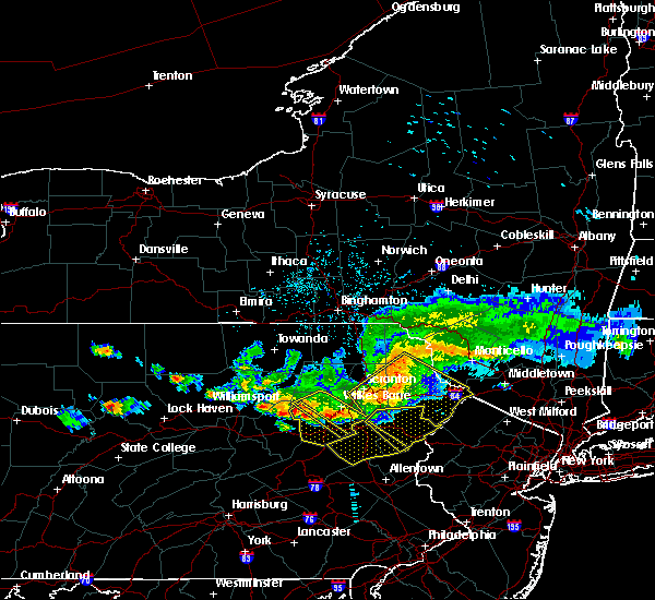 At 542 pm edt, a severe thunderstorm was located over huntington mills, or 9 miles north of berwick, moving southeast at 40 mph (radar indicated). Hazards include 60 mph wind gusts. Expect damage to trees, and power lines. this severe thunderstorm will be near, muhlenberg around 545 pm edt. shickshinny and east berwick around 550 pm edt. nescopeck, pond hill and beach haven around 555 pm edt. slocum and mountain top around 600 pm edt. conyngham and springtown around 605 pm edt. west hazleton and drums around 610 pm edt. Hazleton, freeland and drifton around 615 pm edt. At 542 pm edt, a severe thunderstorm was located over huntington mills, or 9 miles north of berwick, moving southeast at 40 mph (radar indicated). Hazards include 60 mph wind gusts. Expect damage to trees, and power lines. this severe thunderstorm will be near, muhlenberg around 545 pm edt. shickshinny and east berwick around 550 pm edt. nescopeck, pond hill and beach haven around 555 pm edt. slocum and mountain top around 600 pm edt. conyngham and springtown around 605 pm edt. west hazleton and drums around 610 pm edt. Hazleton, freeland and drifton around 615 pm edt.
|
| 7/20/2017 5:35 PM EDT |
 At 534 pm edt, a severe thunderstorm was located over sugar notch, or near wilkes-barre, moving southeast at 35 mph (radar indicated). Hazards include 60 mph wind gusts and quarter size hail. Minor damage to vehicles is possible. expect damage to trees and power lines. this severe thunderstorm will be near, blakeslee around 600 pm edt. albrightsville and lake harmony around 605 pm edt. meckesville and christmans around 610 pm edt. jonas, penn forest reservoir and beltzville state park around 615 pm edt. kresgeville and sun valley around 620 pm edt. gilbert and brodheadsville around 625 pm edt. rossland, kunkletown and saylorsburg around 630 pm edt. Other locations impacted by this severe thunderstorm include trachsville, weissport, fiddletown, parryville, beaver meadows, weissport east, merwinsburg, effort, tresckow and lansford. At 534 pm edt, a severe thunderstorm was located over sugar notch, or near wilkes-barre, moving southeast at 35 mph (radar indicated). Hazards include 60 mph wind gusts and quarter size hail. Minor damage to vehicles is possible. expect damage to trees and power lines. this severe thunderstorm will be near, blakeslee around 600 pm edt. albrightsville and lake harmony around 605 pm edt. meckesville and christmans around 610 pm edt. jonas, penn forest reservoir and beltzville state park around 615 pm edt. kresgeville and sun valley around 620 pm edt. gilbert and brodheadsville around 625 pm edt. rossland, kunkletown and saylorsburg around 630 pm edt. Other locations impacted by this severe thunderstorm include trachsville, weissport, fiddletown, parryville, beaver meadows, weissport east, merwinsburg, effort, tresckow and lansford.
|
| 6/19/2017 2:53 PM EDT |
 At 253 pm edt, a severe thunderstorm was located over tamaqua, moving northeast at 25 mph (radar indicated). Hazards include 60 mph wind gusts. expect damage to trees and power lines At 253 pm edt, a severe thunderstorm was located over tamaqua, moving northeast at 25 mph (radar indicated). Hazards include 60 mph wind gusts. expect damage to trees and power lines
|
| 5/1/2017 8:29 PM EDT |
 At 828 pm edt, severe thunderstorms were located along a line extending from near deposit to near union dale to near berwick, moving east at 40 mph (radar indicated). Hazards include 60 mph wind gusts and penny size hail. Expect damage to roofs, siding, and trees. severe thunderstorms will be near, forest city, union dale and pleasant mount around 835 pm edt. walton, conyngham and waymart around 845 pm edt. west hazleton, prompton and bethany around 850 pm edt. hazleton, honesdale and rutledgedale around 855 pm edt. freeland, corbett and woodside-drifton around 900 pm edt. damascus, callicoon and hortonville around 905 pm edt. cochecton, white haven and lava around 910 pm edt. fosterdale, hazel and livingston manor around 915 pm edt. A tornado watch remains in effect until 1000 pm edt for central new york, and northeastern pennsylvania. At 828 pm edt, severe thunderstorms were located along a line extending from near deposit to near union dale to near berwick, moving east at 40 mph (radar indicated). Hazards include 60 mph wind gusts and penny size hail. Expect damage to roofs, siding, and trees. severe thunderstorms will be near, forest city, union dale and pleasant mount around 835 pm edt. walton, conyngham and waymart around 845 pm edt. west hazleton, prompton and bethany around 850 pm edt. hazleton, honesdale and rutledgedale around 855 pm edt. freeland, corbett and woodside-drifton around 900 pm edt. damascus, callicoon and hortonville around 905 pm edt. cochecton, white haven and lava around 910 pm edt. fosterdale, hazel and livingston manor around 915 pm edt. A tornado watch remains in effect until 1000 pm edt for central new york, and northeastern pennsylvania.
|
| 5/1/2017 7:49 PM EDT |
 At 748 pm edt, severe thunderstorms were located along a line extending from near vestal center to near rushville to lovelton to iola, moving east at 40 to 50 mph (radar indicated). Hazards include 60 mph wind gusts and penny size hail. Expect damage to roofs, siding, and trees. severe thunderstorms will be near, rush, noxen and mehoopany around 755 pm edt. springville, meshoppen and evans falls around 800 pm edt. tunkhannock, montrose and osterhout around 805 pm edt. falls, nescopeck and hallstead around 810 pm edt. muhlenberg, factoryville and shickshinny around 815 pm edt. waverly, clarks summit and susquehanna around 820 pm edt. scranton, dunmore and dickson city around 825 pm edt. carbondale, archbald and olyphant around 830 pm edt. A tornado watch remains in effect until 1000 pm edt for central new york, and northeastern pennsylvania. At 748 pm edt, severe thunderstorms were located along a line extending from near vestal center to near rushville to lovelton to iola, moving east at 40 to 50 mph (radar indicated). Hazards include 60 mph wind gusts and penny size hail. Expect damage to roofs, siding, and trees. severe thunderstorms will be near, rush, noxen and mehoopany around 755 pm edt. springville, meshoppen and evans falls around 800 pm edt. tunkhannock, montrose and osterhout around 805 pm edt. falls, nescopeck and hallstead around 810 pm edt. muhlenberg, factoryville and shickshinny around 815 pm edt. waverly, clarks summit and susquehanna around 820 pm edt. scranton, dunmore and dickson city around 825 pm edt. carbondale, archbald and olyphant around 830 pm edt. A tornado watch remains in effect until 1000 pm edt for central new york, and northeastern pennsylvania.
|
| 7/25/2016 5:19 PM EDT |
 At 518 pm edt, a severe thunderstorm was located over tuscarora, or near tamaqua, moving southeast at 45 mph (radar indicated). Hazards include 60 mph wind gusts and penny size hail. frequent cloud to ground lightning is occurring. Expect damage to roofs. siding. And trees. At 518 pm edt, a severe thunderstorm was located over tuscarora, or near tamaqua, moving southeast at 45 mph (radar indicated). Hazards include 60 mph wind gusts and penny size hail. frequent cloud to ground lightning is occurring. Expect damage to roofs. siding. And trees.
|
| 7/25/2016 3:47 PM EDT |
 At 345 pm edt, a severe thunderstorm was located over penn forest reservoir, or 10 miles northeast of lehighton, moving east at 40 mph (radar indicated). Hazards include 60 mph wind gusts and quarter size hail. Hail damage to vehicles is expected. expect wind damage to roofs, siding, and trees. this severe storm will be near, jonas and kresgeville around 350 pm edt. brodheadsville, gilbert, sun valley and kunkletown around 355 pm edt. mcmichael and rossland around 400 pm edt. Other locations impacted by this severe thunderstorm include summit hill, bowmanstown, tresckow, beaver meadows, lansford, weissport, weissport east, merwinsburg, parryville and effort. At 345 pm edt, a severe thunderstorm was located over penn forest reservoir, or 10 miles northeast of lehighton, moving east at 40 mph (radar indicated). Hazards include 60 mph wind gusts and quarter size hail. Hail damage to vehicles is expected. expect wind damage to roofs, siding, and trees. this severe storm will be near, jonas and kresgeville around 350 pm edt. brodheadsville, gilbert, sun valley and kunkletown around 355 pm edt. mcmichael and rossland around 400 pm edt. Other locations impacted by this severe thunderstorm include summit hill, bowmanstown, tresckow, beaver meadows, lansford, weissport, weissport east, merwinsburg, parryville and effort.
|
| 7/25/2016 3:15 PM EDT |
 At 314 pm edt, a severe thunderstorm was located over mcadoo, or over hazleton, moving east at 40 mph (radar indicated). Hazards include 60 mph wind gusts and quarter size hail. Hail damage to vehicles is expected. expect wind damage to roofs, siding, and trees. this severe thunderstorm will be near, nesquehoning and weatherly around 325 pm edt. jim thorpe around 330 pm edt. lehighton around 335 pm edt. christmans around 340 pm edt. penn forest reservoir, beltzville state park and albrightsville around 345 pm edt. jonas, kresgeville and meckesville around 350 pm edt. gilbert, sun valley, kunkletown, pocono raceway and long pond around 355 pm edt. brodheadsville, mcmichael and rossland around 400 pm edt. Other locations impacted by this severe thunderstorm include summit hill, bowmanstown, tresckow, beaver meadows, lansford, weissport, weissport east, merwinsburg, parryville and effort. At 314 pm edt, a severe thunderstorm was located over mcadoo, or over hazleton, moving east at 40 mph (radar indicated). Hazards include 60 mph wind gusts and quarter size hail. Hail damage to vehicles is expected. expect wind damage to roofs, siding, and trees. this severe thunderstorm will be near, nesquehoning and weatherly around 325 pm edt. jim thorpe around 330 pm edt. lehighton around 335 pm edt. christmans around 340 pm edt. penn forest reservoir, beltzville state park and albrightsville around 345 pm edt. jonas, kresgeville and meckesville around 350 pm edt. gilbert, sun valley, kunkletown, pocono raceway and long pond around 355 pm edt. brodheadsville, mcmichael and rossland around 400 pm edt. Other locations impacted by this severe thunderstorm include summit hill, bowmanstown, tresckow, beaver meadows, lansford, weissport, weissport east, merwinsburg, parryville and effort.
|
| 7/18/2016 1:20 PM EDT |
 At 120 pm edt, severe thunderstorms were located along a line extending from near sweet valley to slocum to beach haven to near rock glen, moving east at 35 mph (radar indicated). Hazards include 60 mph wind gusts and nickel size hail. Damage to roofs. siding. and trees is possible. severe thunderstorms will be near, slocum around 125 pm edt. mountain top around 130 pm edt. edwardsville, luzerne and conyngham around 135 pm edt. west hazleton and penobscot around 140 pm edt. wilkes-barre, hazleton and freeland around 145 pm edt. bear creek, bear creek village and drifton around 150 pm edt. white haven around 155 pm edt. Stoddartsville around 200 pm edt. At 120 pm edt, severe thunderstorms were located along a line extending from near sweet valley to slocum to beach haven to near rock glen, moving east at 35 mph (radar indicated). Hazards include 60 mph wind gusts and nickel size hail. Damage to roofs. siding. and trees is possible. severe thunderstorms will be near, slocum around 125 pm edt. mountain top around 130 pm edt. edwardsville, luzerne and conyngham around 135 pm edt. west hazleton and penobscot around 140 pm edt. wilkes-barre, hazleton and freeland around 145 pm edt. bear creek, bear creek village and drifton around 150 pm edt. white haven around 155 pm edt. Stoddartsville around 200 pm edt.
|
| 7/18/2016 1:03 PM EDT |
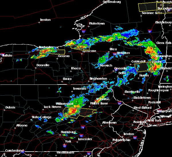 At 103 pm edt, severe thunderstorms were located along a line extending from near huntington mills to mifflinville to near elysburg, moving east at 35 mph (radar indicated). Hazards include 60 mph wind gusts and quarter size hail. Hail damage to vehicles is possible. wind damage to roofs, siding, and trees is possible. these severe storms will be near, berwick, shickshinny and east berwick around 110 pm edt. nescopeck, beach haven and rock glen around 115 pm edt. slocum and pond hill around 120 pm edt. conyngham and mountain top around 125 pm edt. Hazleton, west hazleton and freeland around 130 pm edt. At 103 pm edt, severe thunderstorms were located along a line extending from near huntington mills to mifflinville to near elysburg, moving east at 35 mph (radar indicated). Hazards include 60 mph wind gusts and quarter size hail. Hail damage to vehicles is possible. wind damage to roofs, siding, and trees is possible. these severe storms will be near, berwick, shickshinny and east berwick around 110 pm edt. nescopeck, beach haven and rock glen around 115 pm edt. slocum and pond hill around 120 pm edt. conyngham and mountain top around 125 pm edt. Hazleton, west hazleton and freeland around 130 pm edt.
|
| 7/18/2016 12:35 PM EDT |
 At 1235 pm edt, a severe thunderstorm was located over jerseytown, or 9 miles north of danville, moving east at 40 mph (radar indicated). Hazards include 60 mph wind gusts and quarter size hail. Hail damage to vehicles is expected. expect wind damage to roofs, siding, and trees. this severe thunderstorm will be near, berwick, nescopeck and east berwick around 105 pm edt. beach haven and rock glen around 110 pm edt. pond hill around 115 pm edt. conyngham around 120 pm edt. west hazleton, drums and springtown around 125 pm edt. Hazleton, freeland and drifton around 130 pm edt. At 1235 pm edt, a severe thunderstorm was located over jerseytown, or 9 miles north of danville, moving east at 40 mph (radar indicated). Hazards include 60 mph wind gusts and quarter size hail. Hail damage to vehicles is expected. expect wind damage to roofs, siding, and trees. this severe thunderstorm will be near, berwick, nescopeck and east berwick around 105 pm edt. beach haven and rock glen around 110 pm edt. pond hill around 115 pm edt. conyngham around 120 pm edt. west hazleton, drums and springtown around 125 pm edt. Hazleton, freeland and drifton around 130 pm edt.
|
| 10/9/2015 3:46 PM EDT |
 At 345 pm edt, doppler radar indicated a line of severe thunderstorms capable of producing damaging winds in excess of 60 mph. these storms were located along a line extending from analomink to snyders, moving east at 35 mph. locations impacted include, allentown, lehighton, bethlehem, northampton, east stroudsburg, blairstown, nazareth, palmerton, bangor, jim thorpe, slatington, pen argyl, nesquehoning, wind gap, bath, weatherly, walnutport, hope, belfast and tatamy. At 345 pm edt, doppler radar indicated a line of severe thunderstorms capable of producing damaging winds in excess of 60 mph. these storms were located along a line extending from analomink to snyders, moving east at 35 mph. locations impacted include, allentown, lehighton, bethlehem, northampton, east stroudsburg, blairstown, nazareth, palmerton, bangor, jim thorpe, slatington, pen argyl, nesquehoning, wind gap, bath, weatherly, walnutport, hope, belfast and tatamy.
|
| 10/9/2015 3:17 PM EDT |
 At 316 pm edt, doppler radar indicated a line of severe thunderstorms capable of producing damaging winds in excess of 60 mph. these storms were located along a line extending from near pocono pines to locust lake state park, and moving east at 35 mph. At 316 pm edt, doppler radar indicated a line of severe thunderstorms capable of producing damaging winds in excess of 60 mph. these storms were located along a line extending from near pocono pines to locust lake state park, and moving east at 35 mph.
|
| 6/23/2015 1:41 PM EDT |
 At 140 pm edt, doppler radar indicated a severe thunderstorm capable of producing destructive winds up to 70 mph. this storm was located over rock glen, or 7 miles southeast of berwick, and moving east at 55 mph. At 140 pm edt, doppler radar indicated a severe thunderstorm capable of producing destructive winds up to 70 mph. this storm was located over rock glen, or 7 miles southeast of berwick, and moving east at 55 mph.
|
| 6/23/2015 1:36 PM EDT |
 At 136 pm edt, a severe thunderstorm was located over rock glen, or near berwick, moving east at 65 mph (radar indicated). Hazards include 60 mph wind gusts. Expect damage to roofs. siding and trees. this severe thunderstorm will be near, conyngham around 140 pm edt. hazleton, west hazleton and drums around 145 pm edt. freeland, woodside-drifton and drifton around 150 pm edt. white haven around 155 pm edt. Stoddartsville around 205 pm edt. At 136 pm edt, a severe thunderstorm was located over rock glen, or near berwick, moving east at 65 mph (radar indicated). Hazards include 60 mph wind gusts. Expect damage to roofs. siding and trees. this severe thunderstorm will be near, conyngham around 140 pm edt. hazleton, west hazleton and drums around 145 pm edt. freeland, woodside-drifton and drifton around 150 pm edt. white haven around 155 pm edt. Stoddartsville around 205 pm edt.
|
| 6/11/2015 6:12 PM EDT |
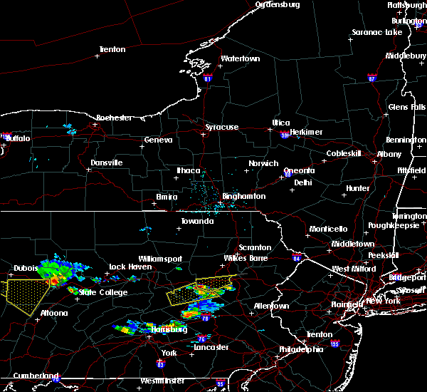 At 611 pm edt, a severe thunderstorm was located over rock glen, or 8 miles southeast of berwick, moving east at 30 mph (radar indicated). Hazards include quarter size hail. Damage to vehicles is expected. this severe thunderstorm will be near, conyngham around 620 pm edt. west hazleton around 625 pm edt. hazleton, drums and springtown around 630 pm edt. freeland, woodside-drifton and drifton around 640 pm edt. White haven around 655 pm edt. At 611 pm edt, a severe thunderstorm was located over rock glen, or 8 miles southeast of berwick, moving east at 30 mph (radar indicated). Hazards include quarter size hail. Damage to vehicles is expected. this severe thunderstorm will be near, conyngham around 620 pm edt. west hazleton around 625 pm edt. hazleton, drums and springtown around 630 pm edt. freeland, woodside-drifton and drifton around 640 pm edt. White haven around 655 pm edt.
|
Hail Maps for Tresckow, PA


Connect with Interactive Hail Maps