

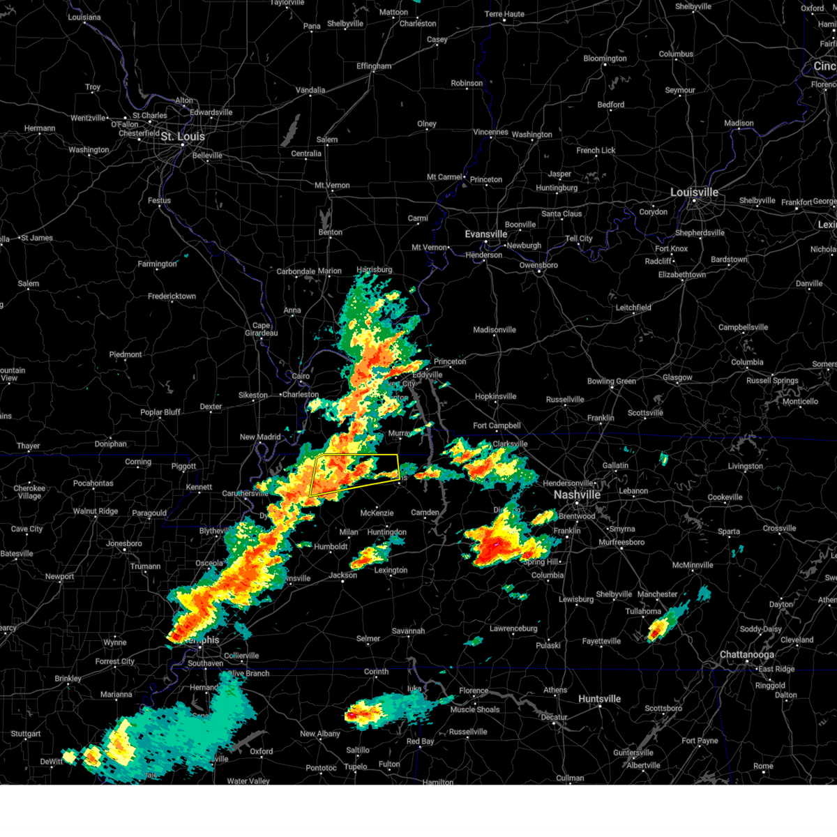
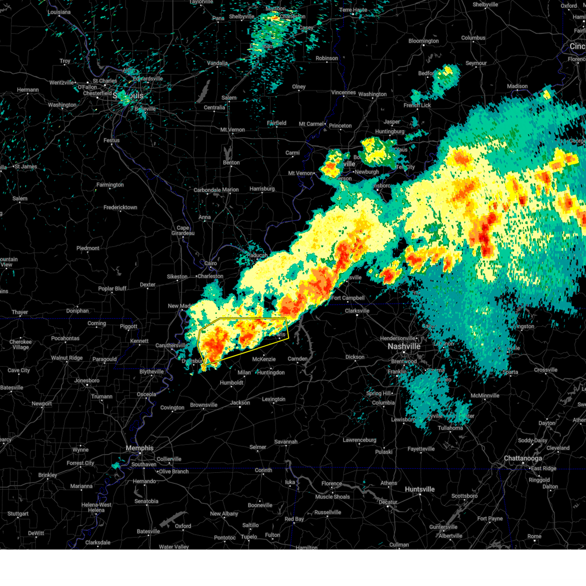
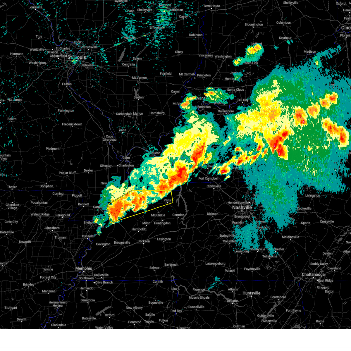
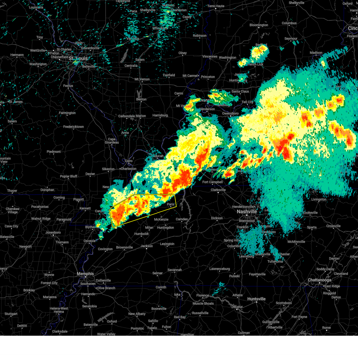
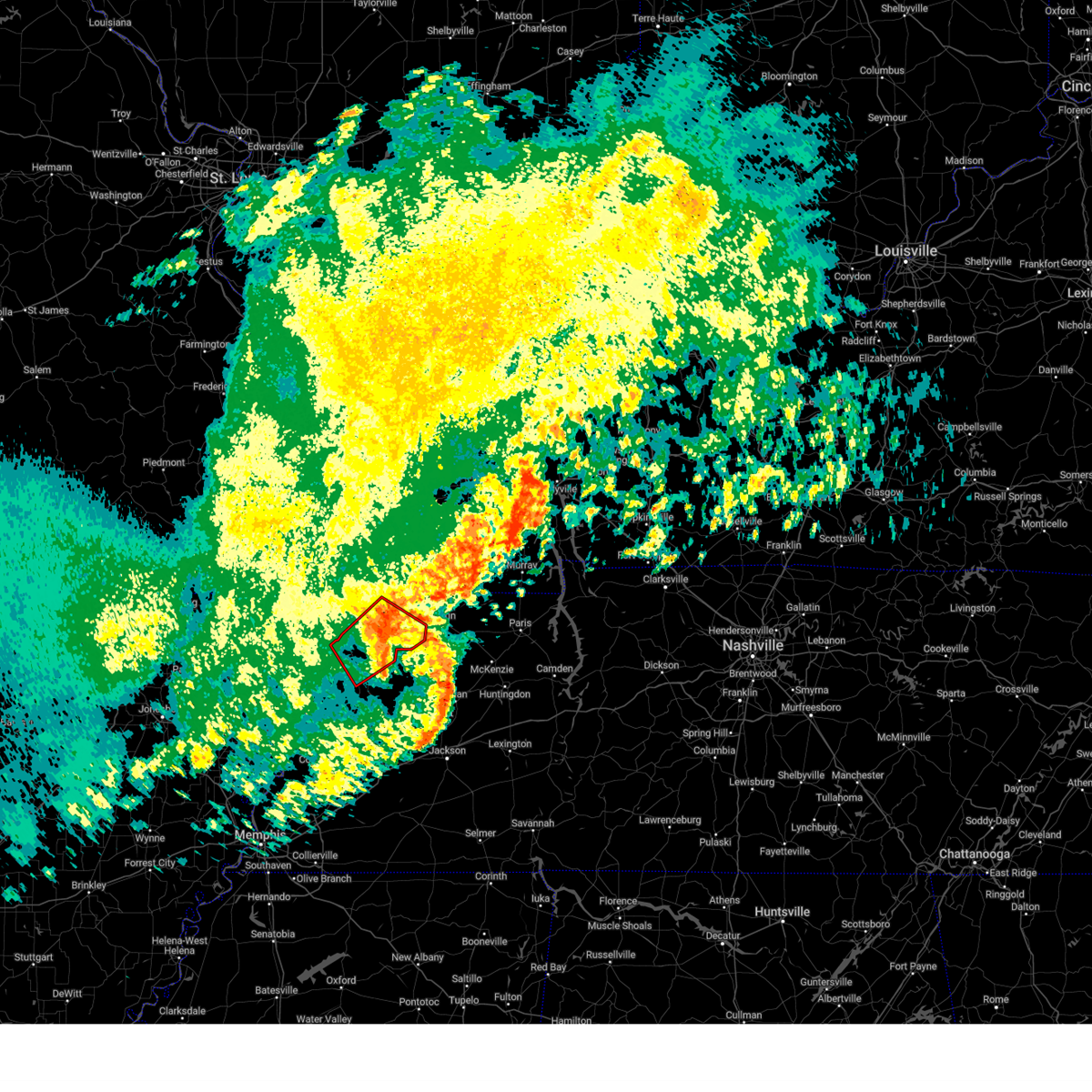
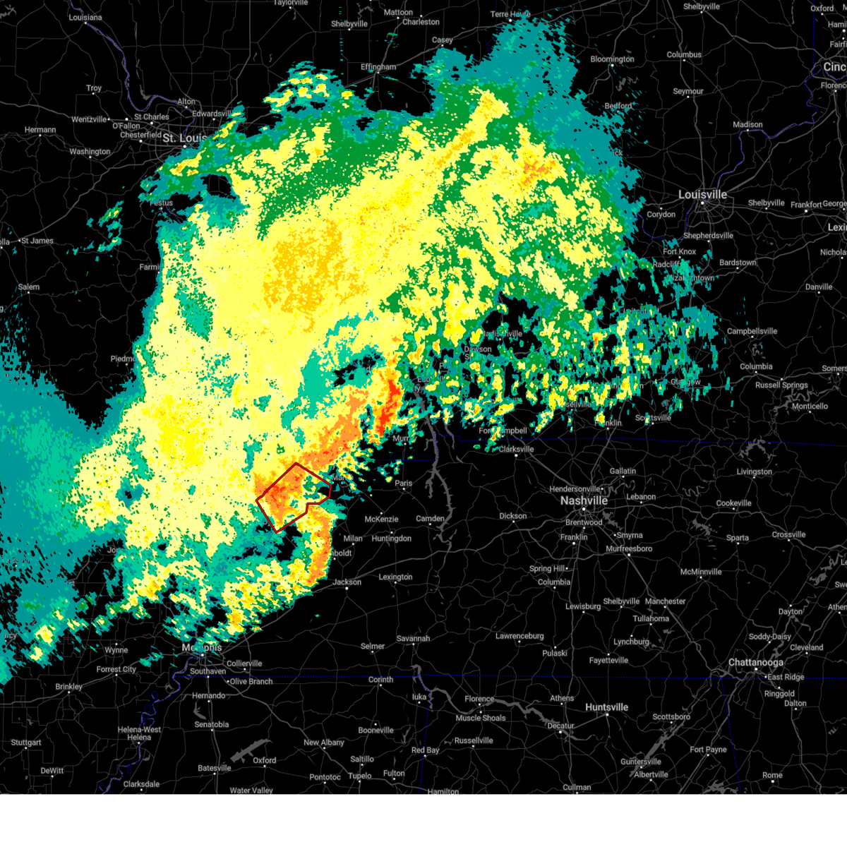
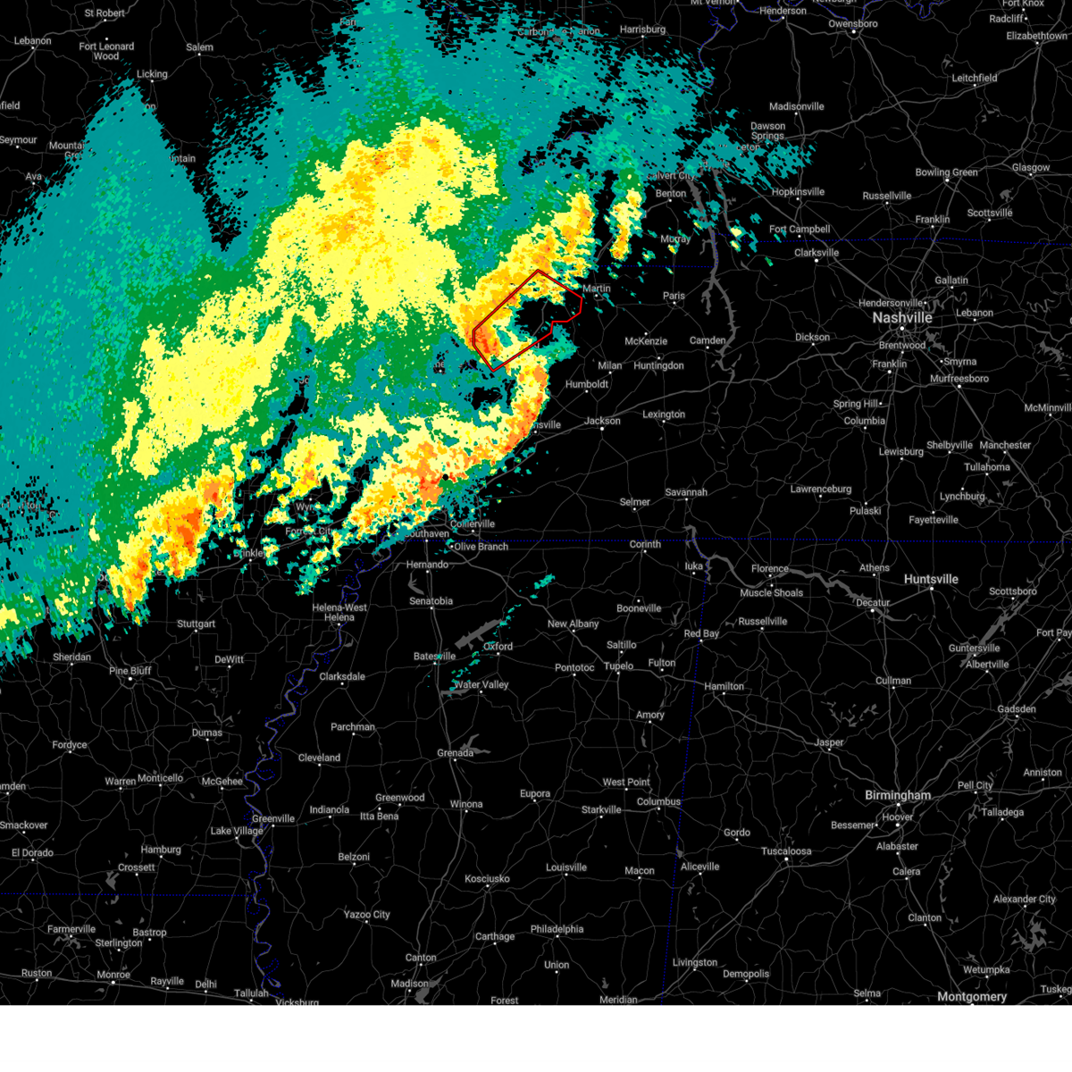
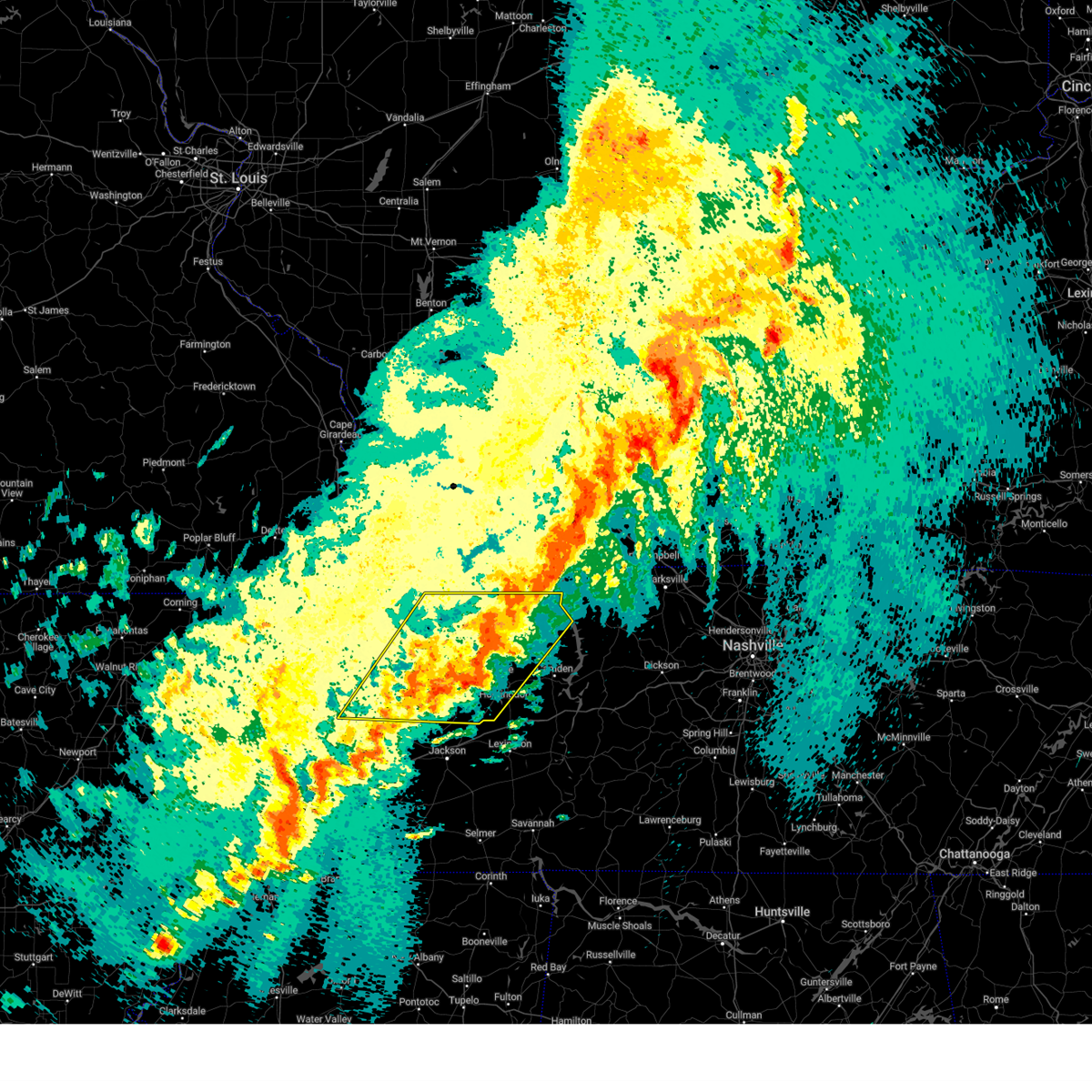
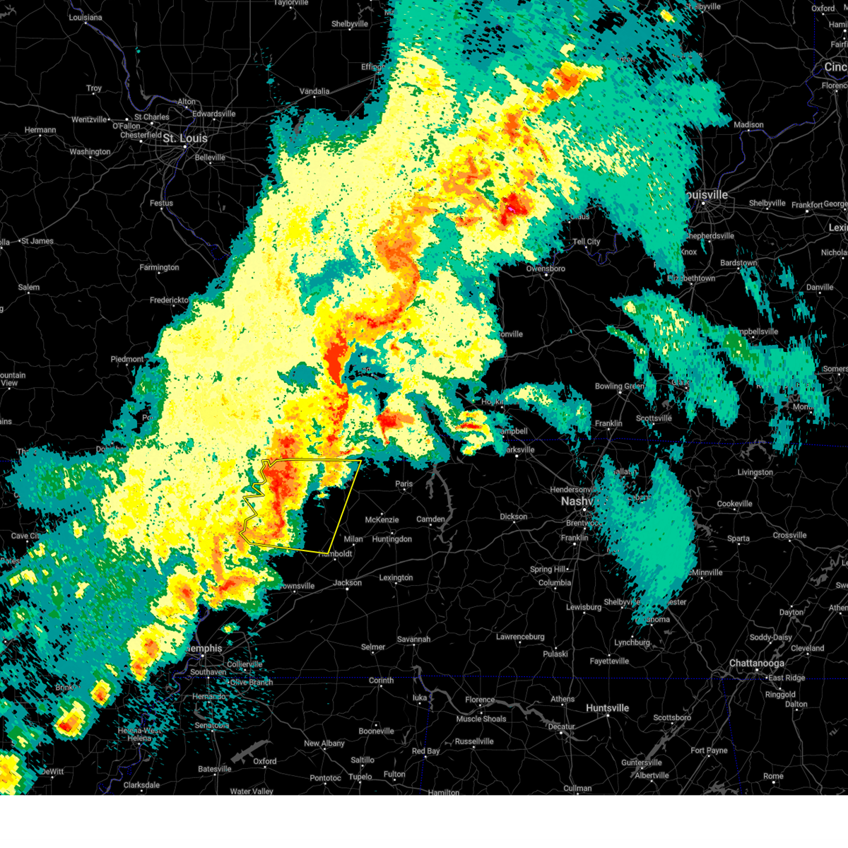
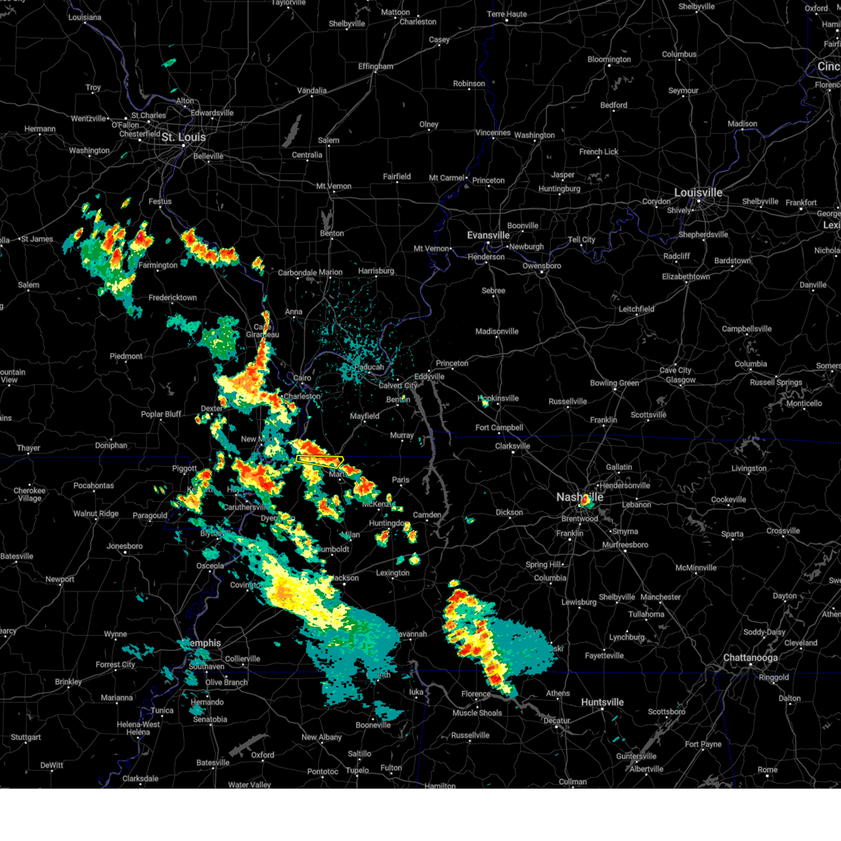
Hail Map for Union City, TN
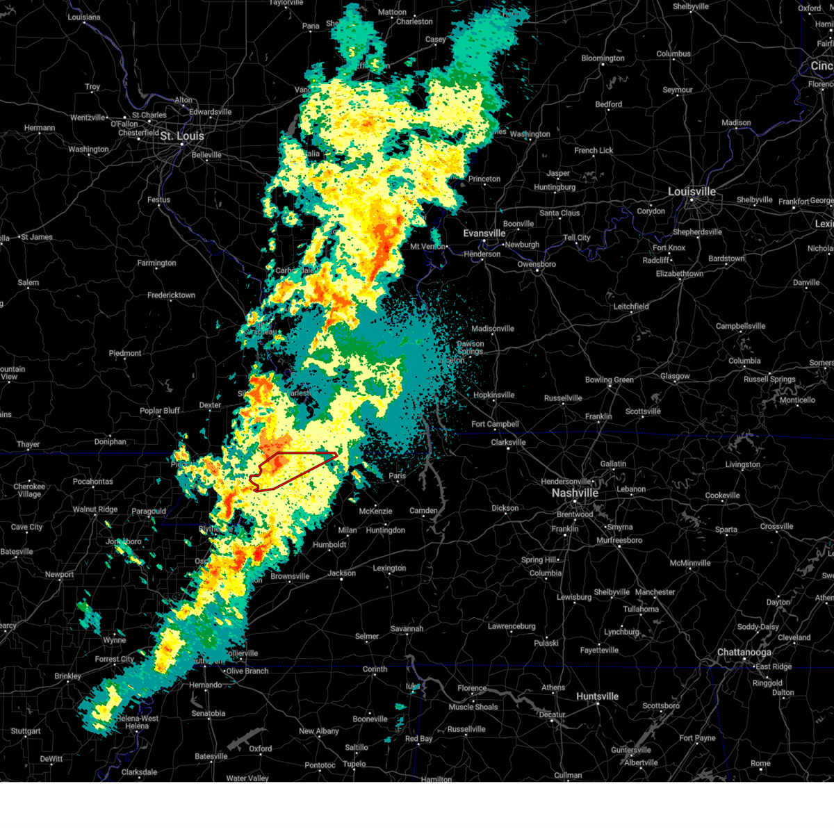
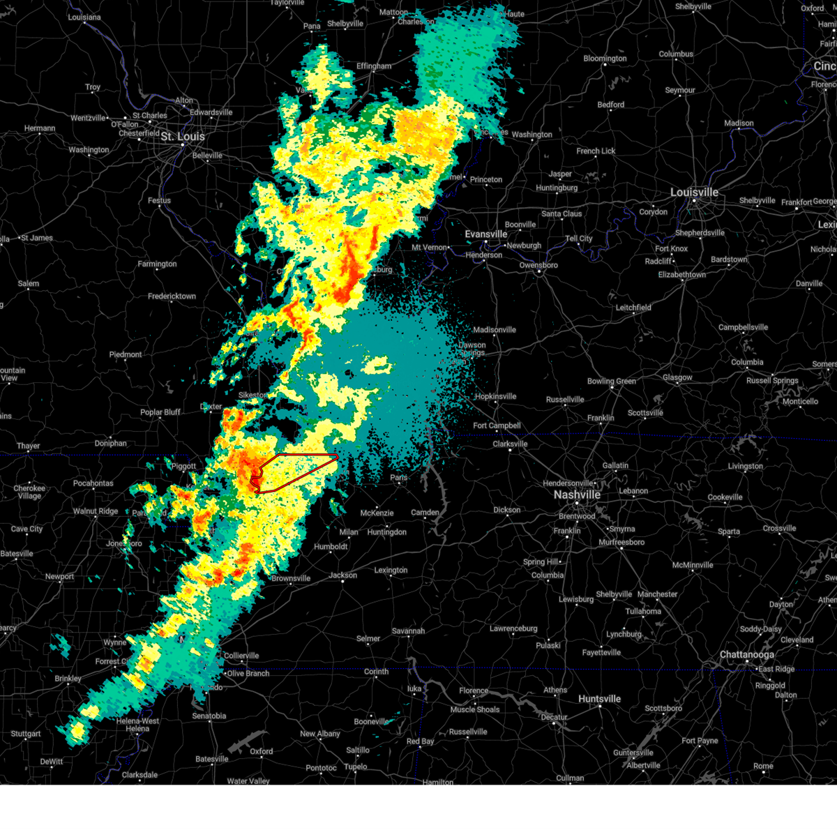
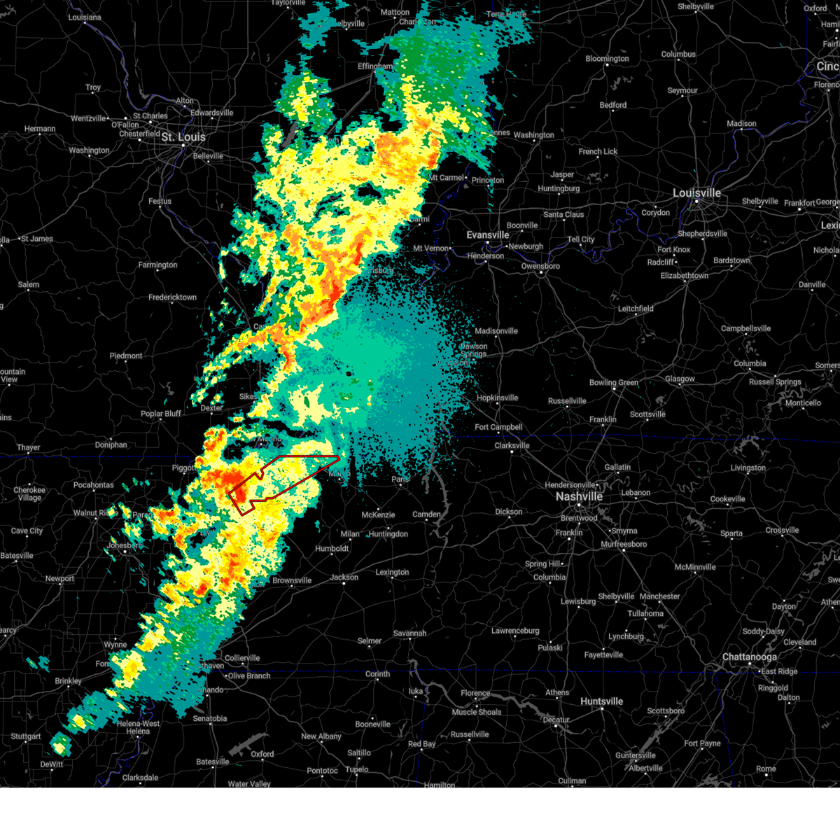
The Union City, TN area has had 6 reports of on-the-ground hail by trained spotters, and has been under severe weather warnings 43 times during the past 12 months. Doppler radar has detected hail at or near Union City, TN on 68 occasions, including 4 occasions during the past year.
| Name: | Union City, TN |
| Where Located: | 36 miles NW of Mc Kenzie, TN |
| Map: | Google Map for Union City, TN |
| Population: | 10895 |
| Housing Units: | 5095 |
| More Info: | Search Google for Union City, TN |
2
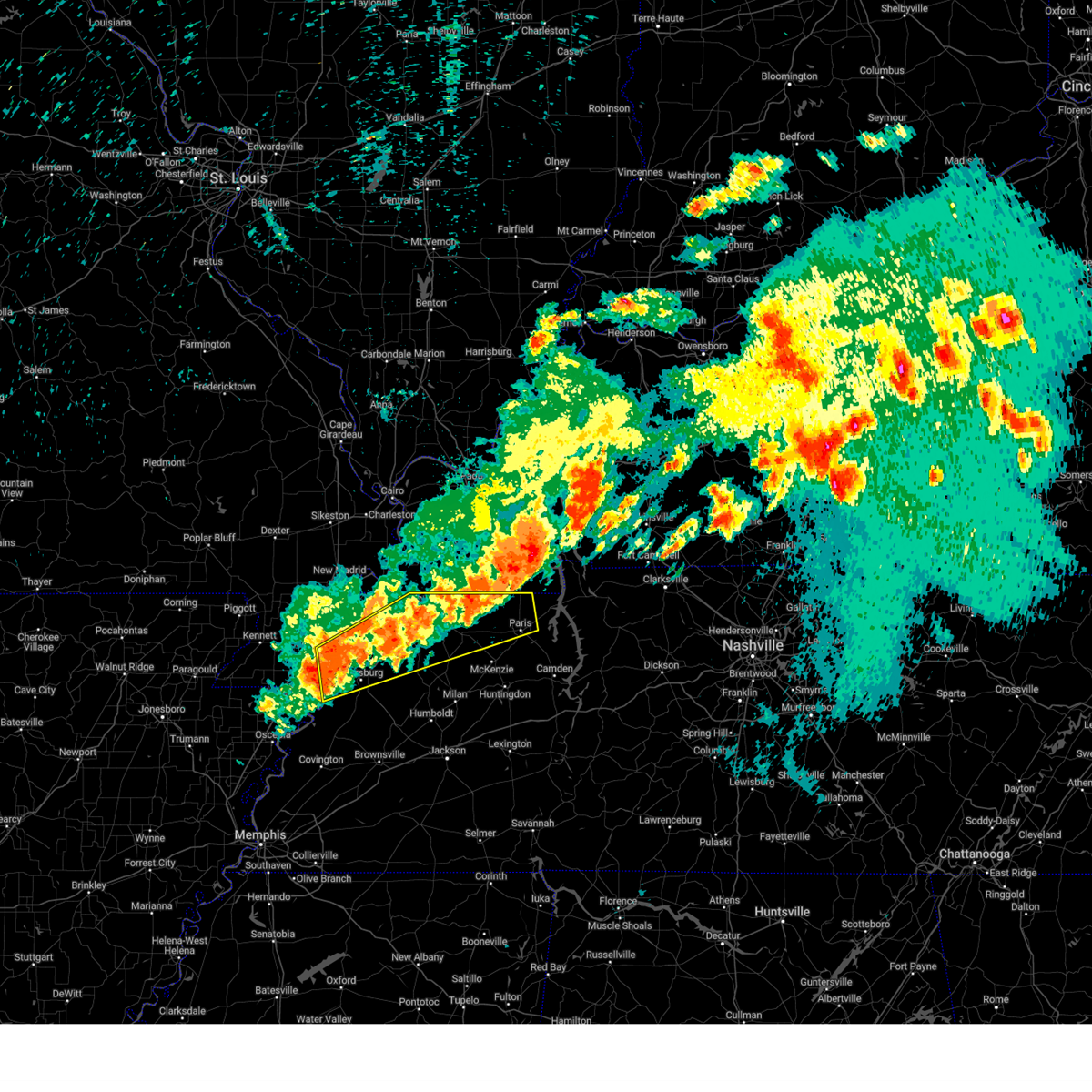
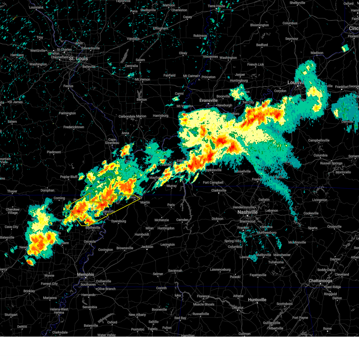
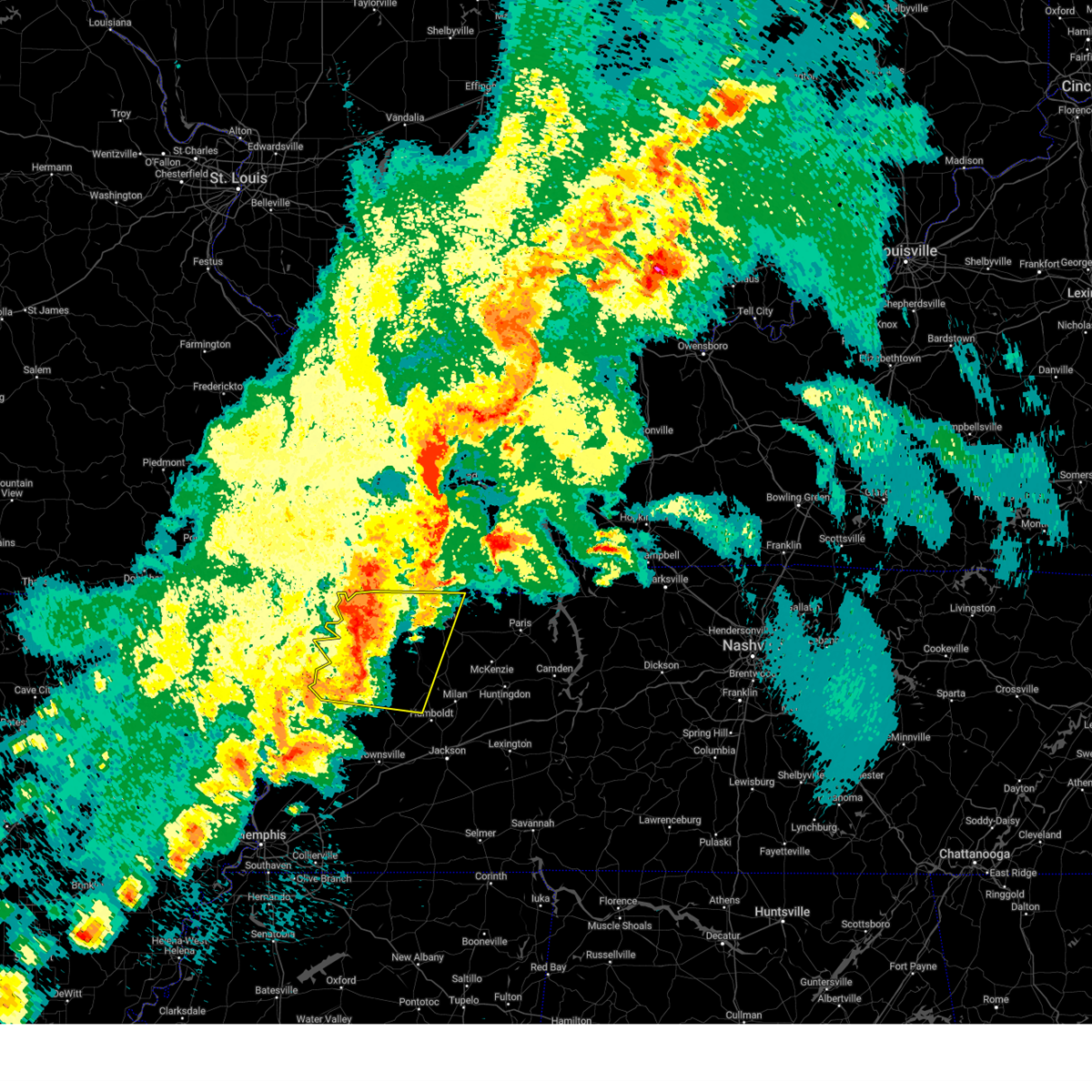
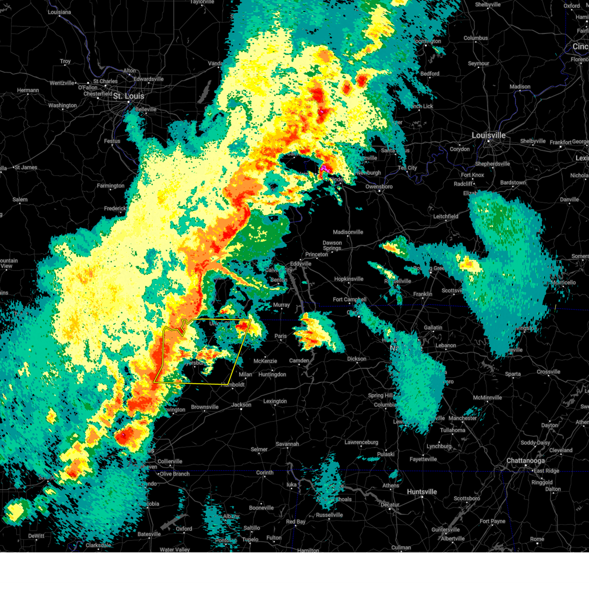
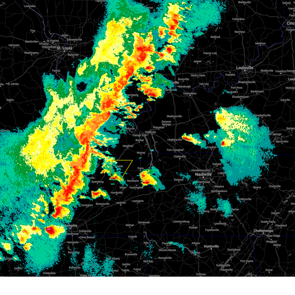
The Top Recent Hail Date for Union City, TN is Tuesday, May 20, 2025 (9th out of 68)

Hail and Wind Damage Spotted near Union City, TN
| Date / Time | Report Details |
|---|---|
| 5/20/2025 3:42 PM CDT |
 Svrmeg the national weather service in memphis has issued a * severe thunderstorm warning for, northern weakley county in west tennessee, eastern obion county in west tennessee, northwestern henry county in west tennessee, * until 430 pm cdt. * at 342 pm cdt, a severe thunderstorm was located near south fulton, or near fulton, moving northeast at 40 mph (radar indicated). Hazards include 60 mph wind gusts and quarter size hail. Hail damage to vehicles is expected. Expect wind damage to roofs, siding, and trees. Svrmeg the national weather service in memphis has issued a * severe thunderstorm warning for, northern weakley county in west tennessee, eastern obion county in west tennessee, northwestern henry county in west tennessee, * until 430 pm cdt. * at 342 pm cdt, a severe thunderstorm was located near south fulton, or near fulton, moving northeast at 40 mph (radar indicated). Hazards include 60 mph wind gusts and quarter size hail. Hail damage to vehicles is expected. Expect wind damage to roofs, siding, and trees.
|
| 5/20/2025 3:30 PM CDT | Awos station kucy union cit in obion county TN, 5.2 miles NW of Union City, TN |
| 5/20/2025 3:26 PM CDT | At 326 pm cdt, a severe thunderstorm was located over union city, moving east at 45 mph (radar indicated). Hazards include 60 mph wind gusts and quarter size hail. Hail damage to vehicles is expected. expect wind damage to roofs, siding, and trees. Locations impacted include, fulton, south fulton, latham, ruthville, union city, shaffner, brundige, terrell, rives, fremont, woodland mills, old fremont, gibbs, moffatt, palmersville, clayton, troy, wolverine, mcconnell, and dukedom. |
| 5/20/2025 3:26 PM CDT | the severe thunderstorm warning has been cancelled and is no longer in effect |
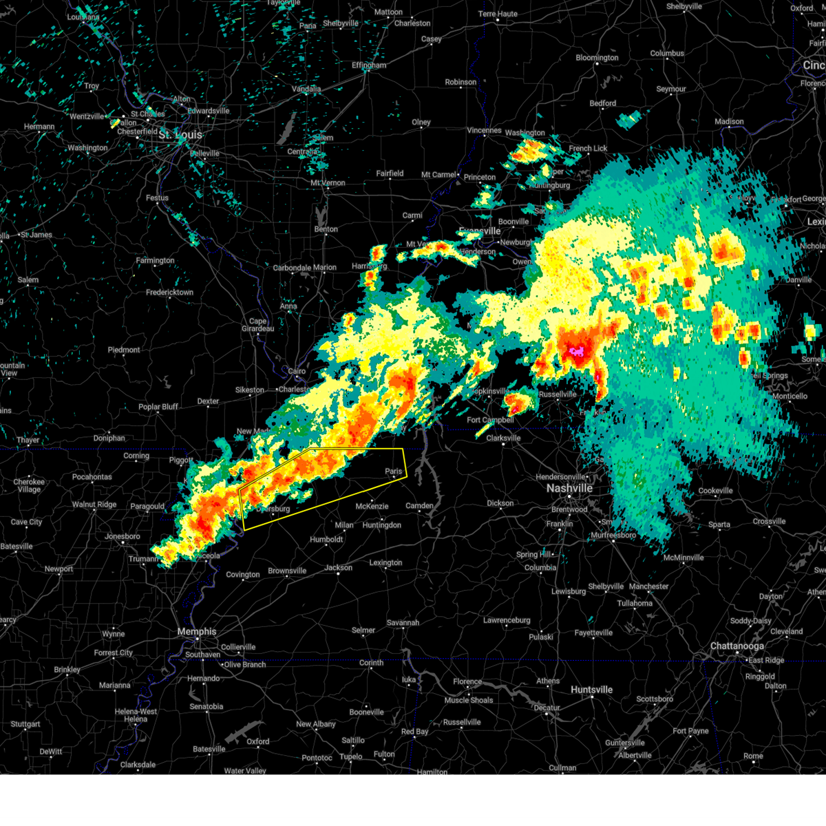
| 5/20/2025 3:05 PM CDT | Svrmeg the national weather service in memphis has issued a * severe thunderstorm warning for, northern weakley county in west tennessee, obion county in west tennessee, southeastern lake county in west tennessee, * until 345 pm cdt. * at 305 pm cdt, a severe thunderstorm was located near clayton, or 7 miles east of reelfoot lake state park, moving east at 45 mph (radar indicated). Hazards include 60 mph wind gusts and quarter size hail. Hail damage to vehicles is expected. Expect wind damage to roofs, siding, and trees. |
| 5/16/2025 10:15 PM CDT | Svrmeg the national weather service in memphis has issued a * severe thunderstorm warning for, weakley county in west tennessee, northern dyer county in west tennessee, northwestern gibson county in west tennessee, obion county in west tennessee, henry county in west tennessee, southeastern lake county in west tennessee, * until 1100 pm cdt. * at 1015 pm cdt, severe thunderstorms were located along a line extending from 7 miles southeast of paris landing state park to dresden to near miston, moving east at 45 mph (radar indicated). Hazards include 60 mph wind gusts and quarter size hail. Hail damage to vehicles is expected. Expect wind damage to roofs, siding, and trees. |
| 5/16/2025 8:52 PM CDT | At 852 pm cdt, severe thunderstorms were located along a line extending from near fulton to reelfoot lake state park to 6 miles west of wardell, moving east at 40 mph (radar indicated). Hazards include 60 mph wind gusts and quarter size hail. Hail damage to vehicles is expected. expect wind damage to roofs, siding, and trees. Locations impacted include, tiptonville, south fulton, latham, shaffner, terrell, pascola, jacksonville, reelfoot national wildlife refuge, peach orchard, madie, spout springs, moffatt, homestown, clayton, troy, wardell, hayti heights, lassiter corner, mccutchen heights, and gratio. |
| 5/16/2025 8:32 PM CDT | Svrmeg the national weather service in memphis has issued a * severe thunderstorm warning for, northern pemiscot county in southeastern missouri, northern weakley county in west tennessee, obion county in west tennessee, lake county in west tennessee, * until 915 pm cdt. * at 831 pm cdt, severe thunderstorms were located along a line extending from near cayce to near reelfoot lake state park to near wardell, moving east at 40 mph (radar indicated). Hazards include 60 mph wind gusts and quarter size hail. Hail damage to vehicles is expected. Expect wind damage to roofs, siding, and trees. |
| 5/16/2025 9:09 AM CDT |
 the severe thunderstorm warning has been cancelled and is no longer in effect the severe thunderstorm warning has been cancelled and is no longer in effect
|
| 5/16/2025 9:09 AM CDT |
 At 909 am cdt, a severe thunderstorm was located near martin, moving northeast at 55 mph (trained weather spotters). Hazards include 60 mph wind gusts and quarter size hail. Hail damage to vehicles is expected. expect wind damage to roofs, siding, and trees. Locations impacted include, south fulton, jones mill, latham, como, ralston, shaffner, rutherford, terrell, pisgah, porter court, ore springs, kenton, moffatt, kimery, india, mill creek, puryear, mccutchen heights, gardner, and sandhill. At 909 am cdt, a severe thunderstorm was located near martin, moving northeast at 55 mph (trained weather spotters). Hazards include 60 mph wind gusts and quarter size hail. Hail damage to vehicles is expected. expect wind damage to roofs, siding, and trees. Locations impacted include, south fulton, jones mill, latham, como, ralston, shaffner, rutherford, terrell, pisgah, porter court, ore springs, kenton, moffatt, kimery, india, mill creek, puryear, mccutchen heights, gardner, and sandhill.
|
| 5/16/2025 9:08 AM CDT |
 Svrmeg the national weather service in memphis has issued a * severe thunderstorm warning for, weakley county in west tennessee, northeastern gibson county in west tennessee, northern benton county in west tennessee, eastern obion county in west tennessee, northwestern carroll county in west tennessee, henry county in west tennessee, * until 1000 am cdt. * at 908 am cdt, a severe thunderstorm was located over martin, moving east at 70 mph (radar indicated). Hazards include 60 mph wind gusts and quarter size hail. Hail damage to vehicles is expected. Expect wind damage to roofs, siding, and trees. Svrmeg the national weather service in memphis has issued a * severe thunderstorm warning for, weakley county in west tennessee, northeastern gibson county in west tennessee, northern benton county in west tennessee, eastern obion county in west tennessee, northwestern carroll county in west tennessee, henry county in west tennessee, * until 1000 am cdt. * at 908 am cdt, a severe thunderstorm was located over martin, moving east at 70 mph (radar indicated). Hazards include 60 mph wind gusts and quarter size hail. Hail damage to vehicles is expected. Expect wind damage to roofs, siding, and trees.
|
| 5/16/2025 8:57 AM CDT |
 the severe thunderstorm warning has been cancelled and is no longer in effect the severe thunderstorm warning has been cancelled and is no longer in effect
|
| 5/16/2025 8:57 AM CDT |
 At 857 am cdt, a severe thunderstorm was located near kenton, or 12 miles south of union city, moving east at 70 mph (trained weather spotters). Hazards include 70 mph wind gusts and quarter size hail. Hail damage to vehicles is expected. expect considerable tree damage. wind damage is also likely to mobile homes, roofs, and outbuildings. Locations impacted include, south fulton, newbern, jones mill, lapata, latham, como, locust grove, ralston, shaffner, rutherford, elbridge, terrell, pisgah, porter court, jacksonville, edgewood, ore springs, kenton, moffatt, and kimery. At 857 am cdt, a severe thunderstorm was located near kenton, or 12 miles south of union city, moving east at 70 mph (trained weather spotters). Hazards include 70 mph wind gusts and quarter size hail. Hail damage to vehicles is expected. expect considerable tree damage. wind damage is also likely to mobile homes, roofs, and outbuildings. Locations impacted include, south fulton, newbern, jones mill, lapata, latham, como, locust grove, ralston, shaffner, rutherford, elbridge, terrell, pisgah, porter court, jacksonville, edgewood, ore springs, kenton, moffatt, and kimery.
|
| 5/16/2025 8:44 AM CDT |
 the severe thunderstorm warning has been cancelled and is no longer in effect the severe thunderstorm warning has been cancelled and is no longer in effect
|
| 5/16/2025 8:44 AM CDT |
 At 844 am cdt, a severe thunderstorm was located over miston, or 8 miles northwest of dyersburg, moving northeast at 40 mph (trained weather spotters). Hazards include 70 mph wind gusts and quarter size hail. Hail damage to vehicles is expected. expect considerable tree damage. wind damage is also likely to mobile homes, roofs, and outbuildings. Locations impacted include, south fulton, newbern, jones mill, lapata, como, ralston, shaffner, rohoboth, terrell, edgewood, ore springs, kenton, madie, lane, moffatt, troy, india, mill creek, nauvoo, and lassiter corner. At 844 am cdt, a severe thunderstorm was located over miston, or 8 miles northwest of dyersburg, moving northeast at 40 mph (trained weather spotters). Hazards include 70 mph wind gusts and quarter size hail. Hail damage to vehicles is expected. expect considerable tree damage. wind damage is also likely to mobile homes, roofs, and outbuildings. Locations impacted include, south fulton, newbern, jones mill, lapata, como, ralston, shaffner, rohoboth, terrell, edgewood, ore springs, kenton, madie, lane, moffatt, troy, india, mill creek, nauvoo, and lassiter corner.
|
| 5/16/2025 8:32 AM CDT |
 At 831 am cdt, a severe thunderstorm was located near union city, moving northeast at 55 mph (trained weather spotters). Hazards include 60 mph wind gusts and quarter size hail. Hail damage to vehicles is expected. expect wind damage to roofs, siding, and trees. Locations impacted include, south fulton, newbern, jones mill, lapata, como, ralston, shaffner, rohoboth, terrell, edgewood, ore springs, kenton, madie, lane, moffatt, troy, india, tennemo, mill creek, and nauvoo. At 831 am cdt, a severe thunderstorm was located near union city, moving northeast at 55 mph (trained weather spotters). Hazards include 60 mph wind gusts and quarter size hail. Hail damage to vehicles is expected. expect wind damage to roofs, siding, and trees. Locations impacted include, south fulton, newbern, jones mill, lapata, como, ralston, shaffner, rohoboth, terrell, edgewood, ore springs, kenton, madie, lane, moffatt, troy, india, tennemo, mill creek, and nauvoo.
|
| 5/16/2025 8:15 AM CDT |
 Svrmeg the national weather service in memphis has issued a * severe thunderstorm warning for, east central pemiscot county in southeastern missouri, weakley county in west tennessee, dyer county in west tennessee, northwestern gibson county in west tennessee, obion county in west tennessee, northwestern henry county in west tennessee, southeastern lake county in west tennessee, * until 915 am cdt. * at 815 am cdt, a severe thunderstorm was located over obion, or 12 miles southeast of reelfoot lake state park, moving northeast at 55 mph (radar indicated). Hazards include 60 mph wind gusts and quarter size hail. Hail damage to vehicles is expected. Expect wind damage to roofs, siding, and trees. Svrmeg the national weather service in memphis has issued a * severe thunderstorm warning for, east central pemiscot county in southeastern missouri, weakley county in west tennessee, dyer county in west tennessee, northwestern gibson county in west tennessee, obion county in west tennessee, northwestern henry county in west tennessee, southeastern lake county in west tennessee, * until 915 am cdt. * at 815 am cdt, a severe thunderstorm was located over obion, or 12 miles southeast of reelfoot lake state park, moving northeast at 55 mph (radar indicated). Hazards include 60 mph wind gusts and quarter size hail. Hail damage to vehicles is expected. Expect wind damage to roofs, siding, and trees.
|
| 5/16/2025 7:54 AM CDT |
 the severe thunderstorm warning has been cancelled and is no longer in effect the severe thunderstorm warning has been cancelled and is no longer in effect
|
| 5/16/2025 7:54 AM CDT |
 At 754 am cdt, a severe thunderstorm was located over deering, or near steele, moving northeast at 50 mph (radar indicated). Hazards include 60 mph wind gusts and quarter size hail. Hail damage to vehicles is expected. expect wind damage to roofs, siding, and trees. Locations impacted include, west hermondale, tiptonville, new survey, denton, gobler, covington, caruthersville, deer land, temples corner, west kennett, pascola, jacksonville, reelfoot national wildlife refuge, peach orchard, samford, madie, spout springs, channel, homestown, and clayton. At 754 am cdt, a severe thunderstorm was located over deering, or near steele, moving northeast at 50 mph (radar indicated). Hazards include 60 mph wind gusts and quarter size hail. Hail damage to vehicles is expected. expect wind damage to roofs, siding, and trees. Locations impacted include, west hermondale, tiptonville, new survey, denton, gobler, covington, caruthersville, deer land, temples corner, west kennett, pascola, jacksonville, reelfoot national wildlife refuge, peach orchard, samford, madie, spout springs, channel, homestown, and clayton.
|
| 5/16/2025 7:24 AM CDT |
 Svrmeg the national weather service in memphis has issued a * severe thunderstorm warning for, northeastern greene county in eastern arkansas, southeastern clay county in eastern arkansas, pemiscot county in southeastern missouri, dunklin county in southeastern missouri, northern obion county in west tennessee, lake county in west tennessee, * until 815 am cdt. * at 724 am cdt, a severe thunderstorm was located near kennett, moving northeast at 55 mph (radar indicated). Hazards include 60 mph wind gusts and quarter size hail. Hail damage to vehicles is expected. Expect wind damage to roofs, siding, and trees. Svrmeg the national weather service in memphis has issued a * severe thunderstorm warning for, northeastern greene county in eastern arkansas, southeastern clay county in eastern arkansas, pemiscot county in southeastern missouri, dunklin county in southeastern missouri, northern obion county in west tennessee, lake county in west tennessee, * until 815 am cdt. * at 724 am cdt, a severe thunderstorm was located near kennett, moving northeast at 55 mph (radar indicated). Hazards include 60 mph wind gusts and quarter size hail. Hail damage to vehicles is expected. Expect wind damage to roofs, siding, and trees.
|
| 4/20/2025 11:55 PM CDT |
 The storm which prompted the warning has weakened below severe limits, and no longer appears capable of producing a tornado. therefore, the warning will be allowed to expire. however, gusty winds are still possible with this thunderstorm. a tornado watch remains in effect until midnight cdt for southeastern missouri. a tornado watch also remains in effect until 400 am cdt for west tennessee. The storm which prompted the warning has weakened below severe limits, and no longer appears capable of producing a tornado. therefore, the warning will be allowed to expire. however, gusty winds are still possible with this thunderstorm. a tornado watch remains in effect until midnight cdt for southeastern missouri. a tornado watch also remains in effect until 400 am cdt for west tennessee.
|
| 4/20/2025 11:37 PM CDT |
 the tornado warning has been cancelled and is no longer in effect the tornado warning has been cancelled and is no longer in effect
|
| 4/20/2025 11:37 PM CDT |
 At 1136 pm cdt, a severe thunderstorm capable of producing a tornado was located near tiptonville, or near reelfoot lake state park, moving northeast at 50 mph (radar indicated rotation). Hazards include tornado. Flying debris will be dangerous to those caught without shelter. mobile homes will be damaged or destroyed. damage to roofs, windows, and vehicles will occur. tree damage is likely. Locations impacted include, tiptonville, wynnburg, south fulton, ridgely, wright, cronanville, union city, roneys store, sunkist beach, blue bank, proctor city, jacksonville, reelfoot national wildlife refuge, samburg, fremont, woodland mills, madie, spout springs, mooring, and walnut log. At 1136 pm cdt, a severe thunderstorm capable of producing a tornado was located near tiptonville, or near reelfoot lake state park, moving northeast at 50 mph (radar indicated rotation). Hazards include tornado. Flying debris will be dangerous to those caught without shelter. mobile homes will be damaged or destroyed. damage to roofs, windows, and vehicles will occur. tree damage is likely. Locations impacted include, tiptonville, wynnburg, south fulton, ridgely, wright, cronanville, union city, roneys store, sunkist beach, blue bank, proctor city, jacksonville, reelfoot national wildlife refuge, samburg, fremont, woodland mills, madie, spout springs, mooring, and walnut log.
|
| 4/20/2025 11:22 PM CDT |
 Tormeg the national weather service in memphis has issued a * tornado warning for, eastern pemiscot county in southeastern missouri, central obion county in west tennessee, lake county in west tennessee, * until midnight cdt. * at 1121 pm cdt, a severe thunderstorm capable of producing a tornado was located over caruthersville, moving northeast at 55 mph (radar indicated rotation). Hazards include tornado. Flying debris will be dangerous to those caught without shelter. mobile homes will be damaged or destroyed. damage to roofs, windows, and vehicles will occur. Tree damage is likely. Tormeg the national weather service in memphis has issued a * tornado warning for, eastern pemiscot county in southeastern missouri, central obion county in west tennessee, lake county in west tennessee, * until midnight cdt. * at 1121 pm cdt, a severe thunderstorm capable of producing a tornado was located over caruthersville, moving northeast at 55 mph (radar indicated rotation). Hazards include tornado. Flying debris will be dangerous to those caught without shelter. mobile homes will be damaged or destroyed. damage to roofs, windows, and vehicles will occur. Tree damage is likely.
|
| 4/5/2025 4:23 AM CDT |
 the tornado warning has been cancelled and is no longer in effect the tornado warning has been cancelled and is no longer in effect
|
| 4/5/2025 4:12 AM CDT |
 At 412 am cdt, a severe thunderstorm capable of producing a tornado was located over cloverdale, or 11 miles north of dyersburg, moving northeast at 50 mph (radar indicated rotation). Hazards include tornado. Flying debris will be dangerous to those caught without shelter. mobile homes will be damaged or destroyed. damage to roofs, windows, and vehicles will occur. tree damage is likely. Locations impacted include, mason hall, cat corner, newbern, ridgely, glass, locust grove, jenkinsville, maxey, roneys store, elbridge, templeton, trimble, bradleytown, rives, jacksonville, miston, samburg, fremont, broadmoor, and sharps ferry. At 412 am cdt, a severe thunderstorm capable of producing a tornado was located over cloverdale, or 11 miles north of dyersburg, moving northeast at 50 mph (radar indicated rotation). Hazards include tornado. Flying debris will be dangerous to those caught without shelter. mobile homes will be damaged or destroyed. damage to roofs, windows, and vehicles will occur. tree damage is likely. Locations impacted include, mason hall, cat corner, newbern, ridgely, glass, locust grove, jenkinsville, maxey, roneys store, elbridge, templeton, trimble, bradleytown, rives, jacksonville, miston, samburg, fremont, broadmoor, and sharps ferry.
|
| 4/5/2025 4:12 AM CDT |
 the tornado warning has been cancelled and is no longer in effect the tornado warning has been cancelled and is no longer in effect
|
| 4/5/2025 3:53 AM CDT |
 Tormeg the national weather service in memphis has issued a * tornado warning for, southeastern pemiscot county in southeastern missouri, dyer county in west tennessee, obion county in west tennessee, southeastern lake county in west tennessee, * until 445 am cdt. * at 353 am cdt, a severe thunderstorm capable of producing a tornado was located near bradleytown, or 8 miles west of dyersburg, moving northeast at 50 mph (radar indicated rotation). Hazards include tornado. Flying debris will be dangerous to those caught without shelter. mobile homes will be damaged or destroyed. damage to roofs, windows, and vehicles will occur. Tree damage is likely. Tormeg the national weather service in memphis has issued a * tornado warning for, southeastern pemiscot county in southeastern missouri, dyer county in west tennessee, obion county in west tennessee, southeastern lake county in west tennessee, * until 445 am cdt. * at 353 am cdt, a severe thunderstorm capable of producing a tornado was located near bradleytown, or 8 miles west of dyersburg, moving northeast at 50 mph (radar indicated rotation). Hazards include tornado. Flying debris will be dangerous to those caught without shelter. mobile homes will be damaged or destroyed. damage to roofs, windows, and vehicles will occur. Tree damage is likely.
|
| 4/2/2025 9:56 PM CDT |
 At 956 pm cdt, severe thunderstorms were located along a line extending from 8 miles south of murray to alamo, moving northeast at 50 mph (radar indicated). Hazards include 60 mph wind gusts and quarter size hail. Hail damage to vehicles is expected. expect wind damage to roofs, siding, and trees. Locations impacted include, tuckers corner, dyer, grizzard, south fulton, bradford, newbern, atwood, fowlkes, jones mill, lapata, cades, bonicord, como, ralston, shaffner, rohoboth, leach, terrell, currie, and mckenzie. At 956 pm cdt, severe thunderstorms were located along a line extending from 8 miles south of murray to alamo, moving northeast at 50 mph (radar indicated). Hazards include 60 mph wind gusts and quarter size hail. Hail damage to vehicles is expected. expect wind damage to roofs, siding, and trees. Locations impacted include, tuckers corner, dyer, grizzard, south fulton, bradford, newbern, atwood, fowlkes, jones mill, lapata, cades, bonicord, como, ralston, shaffner, rohoboth, leach, terrell, currie, and mckenzie.
|
| 4/2/2025 9:50 PM CDT | Svrmeg the national weather service in memphis has issued a * severe thunderstorm warning for, central crockett county in west tennessee, weakley county in west tennessee, eastern dyer county in west tennessee, gibson county in west tennessee, northwestern benton county in west tennessee, eastern obion county in west tennessee, northeastern lauderdale county in west tennessee, carroll county in west tennessee, henry county in west tennessee, * until 1045 pm cdt. * at 950 pm cdt, severe thunderstorms were located along a line extending from 8 miles northeast of cottage grove to near alamo, moving northeast at 50 mph (radar indicated). Hazards include 60 mph wind gusts and quarter size hail. Hail damage to vehicles is expected. Expect wind damage to roofs, siding, and trees. |
| 4/2/2025 8:32 PM CDT | Tormeg the national weather service in memphis has issued a * tornado warning for, weakley county in west tennessee, northeastern dyer county in west tennessee, northwestern gibson county in west tennessee, eastern obion county in west tennessee, west central henry county in west tennessee, * until 915 pm cdt. * at 832 pm cdt, a severe thunderstorm capable of producing a tornado was located near newbern, or 13 miles northeast of dyersburg, moving northeast at 55 mph (radar indicated rotation). Hazards include tornado. Flying debris will be dangerous to those caught without shelter. mobile homes will be damaged or destroyed. damage to roofs, windows, and vehicles will occur. Tree damage is likely. |
| 4/2/2025 8:32 PM CDT | the severe thunderstorm warning has been cancelled and is no longer in effect |
| 4/2/2025 8:32 PM CDT | At 831 pm cdt, severe thunderstorms were located along a line extending from near clayton to near cloverdale to unionville, moving northeast at 45 mph (radar indicated). Hazards include 60 mph wind gusts and quarter size hail. Hail damage to vehicles is expected. expect wind damage to roofs, siding, and trees. Locations impacted include, dyer, grizzard, south fulton, newbern, fowlkes, lapata, bonicord, ralston, shaffner, rohoboth, terrell, currie, georgetown, edgewood, laneview, kenton, poplar grove, spout springs, parker, and lane. |
| 4/2/2025 8:20 PM CDT |
 the severe thunderstorm warning has been cancelled and is no longer in effect the severe thunderstorm warning has been cancelled and is no longer in effect
|
| 4/2/2025 8:20 PM CDT |
 At 820 pm cdt, severe thunderstorms were located along a line extending from near clayton to cloverdale to near bradleytown, moving northeast at 75 mph (radar indicated). Hazards include 60 mph wind gusts and quarter size hail. Hail damage to vehicles is expected. expect wind damage to roofs, siding, and trees. Locations impacted include, tiptonville, dyer, grizzard, south fulton, newbern, fowlkes, lapata, bonicord, ralston, shaffner, rohoboth, terrell, currie, reelfoot national wildlife refuge, georgetown, edgewood, laneview, kenton, poplar grove, and madie. At 820 pm cdt, severe thunderstorms were located along a line extending from near clayton to cloverdale to near bradleytown, moving northeast at 75 mph (radar indicated). Hazards include 60 mph wind gusts and quarter size hail. Hail damage to vehicles is expected. expect wind damage to roofs, siding, and trees. Locations impacted include, tiptonville, dyer, grizzard, south fulton, newbern, fowlkes, lapata, bonicord, ralston, shaffner, rohoboth, terrell, currie, reelfoot national wildlife refuge, georgetown, edgewood, laneview, kenton, poplar grove, and madie.
|
| 4/2/2025 8:07 PM CDT | the severe thunderstorm warning has been cancelled and is no longer in effect |
| 4/2/2025 8:07 PM CDT |
 Svrmeg the national weather service in memphis has issued a * severe thunderstorm warning for, northeastern mississippi county in eastern arkansas, central pemiscot county in southeastern missouri, northwestern crockett county in west tennessee, western weakley county in west tennessee, dyer county in west tennessee, western gibson county in west tennessee, obion county in west tennessee, northeastern lauderdale county in west tennessee, lake county in west tennessee, * until 900 pm cdt. * at 806 pm cdt, severe thunderstorms were located along a line extending from tiptonville to near miston to 7 miles south of heloise, moving northeast at 60 mph (radar indicated). Hazards include 60 mph wind gusts and quarter size hail. Hail damage to vehicles is expected. Expect wind damage to roofs, siding, and trees. Svrmeg the national weather service in memphis has issued a * severe thunderstorm warning for, northeastern mississippi county in eastern arkansas, central pemiscot county in southeastern missouri, northwestern crockett county in west tennessee, western weakley county in west tennessee, dyer county in west tennessee, western gibson county in west tennessee, obion county in west tennessee, northeastern lauderdale county in west tennessee, lake county in west tennessee, * until 900 pm cdt. * at 806 pm cdt, severe thunderstorms were located along a line extending from tiptonville to near miston to 7 miles south of heloise, moving northeast at 60 mph (radar indicated). Hazards include 60 mph wind gusts and quarter size hail. Hail damage to vehicles is expected. Expect wind damage to roofs, siding, and trees.
|
| 4/2/2025 7:42 PM CDT | At 741 pm cdt, a severe thunderstorm was located near martin, moving northeast at 60 mph (emergency management). Hazards include golf ball size hail and 60 mph wind gusts. People and animals outdoors will be injured. expect hail damage to roofs, siding, windows, and vehicles. expect wind damage to roofs, siding, and trees. Locations impacted include, sidonia, south fulton, hyndsver, mount pelia, gibbs, latham, martin, ruthville, sharon, ralston, shaffner, brundige, terrell, mcconnell, pisgah, gardner, matheny grove, fulton, dresden, and union city. |
| 4/2/2025 7:42 PM CDT | the severe thunderstorm warning has been cancelled and is no longer in effect |
| 4/2/2025 7:36 PM CDT |
 At 736 pm cdt, a severe thunderstorm was located near kenton, or 8 miles southwest of martin, moving northeast at 60 mph (radar indicated). Hazards include 60 mph wind gusts and quarter size hail. Hail damage to vehicles is expected. expect wind damage to roofs, siding, and trees. Locations impacted include, south fulton, dresden, mount pelia, latham, ruthville, sharon, ralston, shaffner, brundige, terrell, pisgah, matheny grove, kenton, sidonia, hyndsver, gibbs, martin, kimery, greenfield, and big cypress tree state park. At 736 pm cdt, a severe thunderstorm was located near kenton, or 8 miles southwest of martin, moving northeast at 60 mph (radar indicated). Hazards include 60 mph wind gusts and quarter size hail. Hail damage to vehicles is expected. expect wind damage to roofs, siding, and trees. Locations impacted include, south fulton, dresden, mount pelia, latham, ruthville, sharon, ralston, shaffner, brundige, terrell, pisgah, matheny grove, kenton, sidonia, hyndsver, gibbs, martin, kimery, greenfield, and big cypress tree state park.
|
| 4/2/2025 7:24 PM CDT | Svrmeg the national weather service in memphis has issued a * severe thunderstorm warning for, weakley county in west tennessee, northern gibson county in west tennessee, eastern obion county in west tennessee, * until 830 pm cdt. * at 723 pm cdt, a severe thunderstorm was located near dyer, or 9 miles northwest of trenton, moving northeast at 60 mph (radar indicated). Hazards include 60 mph wind gusts and quarter size hail. Hail damage to vehicles is expected. Expect wind damage to roofs, siding, and trees. |
| 3/30/2025 8:01 PM CDT | At 801 pm cdt, severe thunderstorms were located along a line extending from near clayton to ridgely to near cooter, moving east at 60 mph (radar indicated). Hazards include 60 mph wind gusts and quarter size hail. Hail damage to vehicles is expected. expect wind damage to roofs, siding, and trees. Locations impacted include, tiptonville, south fulton, newbern, fowlkes, new survey, lapata, covington, ralston, shaffner, rohoboth, terrell, reelfoot national wildlife refuge, edgewood, kenton, madie, spout springs, parker, lane, moffatt, and clayton. |
| 3/30/2025 8:01 PM CDT | the severe thunderstorm warning has been cancelled and is no longer in effect |
| 3/30/2025 7:45 PM CDT | Svrmeg the national weather service in memphis has issued a * severe thunderstorm warning for, pemiscot county in southeastern missouri, southeastern dunklin county in southeastern missouri, northwestern weakley county in west tennessee, dyer county in west tennessee, northwestern gibson county in west tennessee, obion county in west tennessee, lake county in west tennessee, * until 830 pm cdt. * at 745 pm cdt, severe thunderstorms were located along a line extending from 6 miles northwest of tiptonville to hayti to near hornersville, moving east at 60 mph (radar indicated). Hazards include 60 mph wind gusts and quarter size hail. Hail damage to vehicles is expected. Expect wind damage to roofs, siding, and trees. |
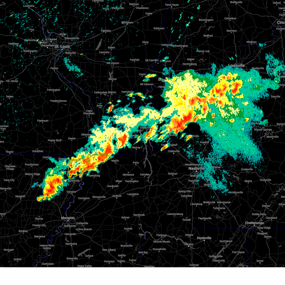
| 2/15/2025 7:43 PM CST | Quarter sized hail reported 0.6 miles N of Union City, TN, quarter size hail in downtown paris. |
| 6/9/2024 1:28 AM CDT |
 Svrmeg the national weather service in memphis has issued a * severe thunderstorm warning for, weakley county in west tennessee, gibson county in west tennessee, eastern obion county in west tennessee, carroll county in west tennessee, western henry county in west tennessee, * until 215 am cdt. * at 128 am cdt, severe thunderstorms were located along a line extending from near union city to near bradford to near humboldt, moving east at 55 mph (radar indicated). Hazards include 60 mph wind gusts and nickel size hail. expect damage to roofs, siding, and trees Svrmeg the national weather service in memphis has issued a * severe thunderstorm warning for, weakley county in west tennessee, gibson county in west tennessee, eastern obion county in west tennessee, carroll county in west tennessee, western henry county in west tennessee, * until 215 am cdt. * at 128 am cdt, severe thunderstorms were located along a line extending from near union city to near bradford to near humboldt, moving east at 55 mph (radar indicated). Hazards include 60 mph wind gusts and nickel size hail. expect damage to roofs, siding, and trees
|
| 6/9/2024 1:11 AM CDT |
 At 110 am cdt, severe thunderstorms were located along a line extending from near martin to near eaton to near fulton, moving southeast at 45 mph (trained weather spotters. at 103 am cdt, 60 mph winds were reported in east dyersburg). Hazards include 60 mph wind gusts and quarter size hail. Hail damage to vehicles is expected. expect wind damage to roofs, siding, and trees. Locations impacted include, dyersburg, martin, union city, covington, ripley, osceola, trenton, luxora, wilson, keiser, fort pillow state park, munford, newbern, dresden, brighton, alamo, dyer, halls, greenfield, and troy. At 110 am cdt, severe thunderstorms were located along a line extending from near martin to near eaton to near fulton, moving southeast at 45 mph (trained weather spotters. at 103 am cdt, 60 mph winds were reported in east dyersburg). Hazards include 60 mph wind gusts and quarter size hail. Hail damage to vehicles is expected. expect wind damage to roofs, siding, and trees. Locations impacted include, dyersburg, martin, union city, covington, ripley, osceola, trenton, luxora, wilson, keiser, fort pillow state park, munford, newbern, dresden, brighton, alamo, dyer, halls, greenfield, and troy.
|
| 6/9/2024 12:45 AM CDT |
 Svrmeg the national weather service in memphis has issued a * severe thunderstorm warning for, central mississippi county in eastern arkansas, northwestern crockett county in west tennessee, tipton county in west tennessee, weakley county in west tennessee, dyer county in west tennessee, gibson county in west tennessee, obion county in west tennessee, lauderdale county in west tennessee, northwestern haywood county in west tennessee, * until 130 am cdt. * at 1244 am cdt, severe thunderstorms were located along a line extending from clayton to 6 miles southwest of miston to near dyess, moving east at 40 mph (radar indicated). Hazards include 60 mph wind gusts and quarter size hail. Hail damage to vehicles is expected. Expect wind damage to roofs, siding, and trees. Svrmeg the national weather service in memphis has issued a * severe thunderstorm warning for, central mississippi county in eastern arkansas, northwestern crockett county in west tennessee, tipton county in west tennessee, weakley county in west tennessee, dyer county in west tennessee, gibson county in west tennessee, obion county in west tennessee, lauderdale county in west tennessee, northwestern haywood county in west tennessee, * until 130 am cdt. * at 1244 am cdt, severe thunderstorms were located along a line extending from clayton to 6 miles southwest of miston to near dyess, moving east at 40 mph (radar indicated). Hazards include 60 mph wind gusts and quarter size hail. Hail damage to vehicles is expected. Expect wind damage to roofs, siding, and trees.
|
| 6/3/2024 3:50 PM CDT |
 The storm which prompted the warning has weakened below severe limits, and has exited the warned area. therefore, the warning will be allowed to expire. The storm which prompted the warning has weakened below severe limits, and has exited the warned area. therefore, the warning will be allowed to expire.
|
| 6/3/2024 3:45 PM CDT |
 At 345 pm cdt, a severe thunderstorm was located near cayce, or near fulton, moving north at 20 mph (radar indicated). Hazards include quarter size hail. Damage to vehicles is expected. Locations impacted include, union city, fulton, south fulton, woodland mills, and crystal. At 345 pm cdt, a severe thunderstorm was located near cayce, or near fulton, moving north at 20 mph (radar indicated). Hazards include quarter size hail. Damage to vehicles is expected. Locations impacted include, union city, fulton, south fulton, woodland mills, and crystal.
|
| 6/3/2024 3:36 PM CDT | Quarter sized hail reported 0.5 miles E of Union City, TN |
| 6/3/2024 3:29 PM CDT |
 Svrmeg the national weather service in memphis has issued a * severe thunderstorm warning for, northeastern obion county in west tennessee, * until 400 pm cdt. * at 329 pm cdt, a severe thunderstorm was located over union city, moving north at 20 mph (radar indicated). Hazards include quarter size hail. damage to vehicles is expected Svrmeg the national weather service in memphis has issued a * severe thunderstorm warning for, northeastern obion county in west tennessee, * until 400 pm cdt. * at 329 pm cdt, a severe thunderstorm was located over union city, moving north at 20 mph (radar indicated). Hazards include quarter size hail. damage to vehicles is expected
|
| 5/27/2024 12:07 AM CDT |
 The storms which prompted the warning have weakened below severe limits, and no longer pose an immediate threat to life or property. therefore, the warning will be allowed to expire. however, gusty winds are still possible with these thunderstorms. a tornado watch remains in effect until 500 am cdt for west tennessee. a tornado watch also remains in effect until 400 am cdt for west tennessee. The storms which prompted the warning have weakened below severe limits, and no longer pose an immediate threat to life or property. therefore, the warning will be allowed to expire. however, gusty winds are still possible with these thunderstorms. a tornado watch remains in effect until 500 am cdt for west tennessee. a tornado watch also remains in effect until 400 am cdt for west tennessee.
|
| 5/26/2024 11:55 PM CDT |
 At 1155 pm cdt, severe thunderstorms were located along a line extending from near tennessee ridge to near huntingdon to near dyersburg, moving southeast at 25 mph (radar indicated). Hazards include 60 mph wind gusts and nickel size hail. Expect damage to roofs, siding, and trees. Locations impacted include, dyersburg, martin, union city, paris, milan, mckenzie, trenton, huntingdon, camden, fulton, paris landing state park, reelfoot lake state park, tiptonville, newbern, dresden, south fulton, dyer, greenfield, new johnsonville, and ridgely. At 1155 pm cdt, severe thunderstorms were located along a line extending from near tennessee ridge to near huntingdon to near dyersburg, moving southeast at 25 mph (radar indicated). Hazards include 60 mph wind gusts and nickel size hail. Expect damage to roofs, siding, and trees. Locations impacted include, dyersburg, martin, union city, paris, milan, mckenzie, trenton, huntingdon, camden, fulton, paris landing state park, reelfoot lake state park, tiptonville, newbern, dresden, south fulton, dyer, greenfield, new johnsonville, and ridgely.
|
| 5/26/2024 11:30 PM CDT |
 Svrmeg the national weather service in memphis has issued a * severe thunderstorm warning for, weakley county in west tennessee, northeastern dyer county in west tennessee, gibson county in west tennessee, benton county in west tennessee, obion county in west tennessee, carroll county in west tennessee, henry county in west tennessee, northeastern decatur county in west tennessee, lake county in west tennessee, * until 1215 am cdt. * at 1130 pm cdt, severe thunderstorms were located along a line extending from near paris landing state park to near huntingdon to cottonwood grove, moving southeast at 25 mph (radar indicated). Hazards include 60 mph wind gusts and nickel size hail. expect damage to roofs, siding, and trees Svrmeg the national weather service in memphis has issued a * severe thunderstorm warning for, weakley county in west tennessee, northeastern dyer county in west tennessee, gibson county in west tennessee, benton county in west tennessee, obion county in west tennessee, carroll county in west tennessee, henry county in west tennessee, northeastern decatur county in west tennessee, lake county in west tennessee, * until 1215 am cdt. * at 1130 pm cdt, severe thunderstorms were located along a line extending from near paris landing state park to near huntingdon to cottonwood grove, moving southeast at 25 mph (radar indicated). Hazards include 60 mph wind gusts and nickel size hail. expect damage to roofs, siding, and trees
|
| 5/26/2024 8:27 AM CDT |
 The storms which prompted the warning have moved out of the area. therefore, the warning will be allowed to expire. a tornado watch remains in effect until 1000 am cdt for west tennessee. remember, a severe thunderstorm warning still remains in effect for weakley, henry, and northern carroll counties. The storms which prompted the warning have moved out of the area. therefore, the warning will be allowed to expire. a tornado watch remains in effect until 1000 am cdt for west tennessee. remember, a severe thunderstorm warning still remains in effect for weakley, henry, and northern carroll counties.
|
| 5/26/2024 8:18 AM CDT |
 At 817 am cdt, severe thunderstorms were located along a line extending from near martin to near kenton to near rutherford, moving east at 50 mph (radar indicated). Hazards include 60 mph wind gusts and quarter size hail. Hail damage to vehicles is expected. expect wind damage to roofs, siding, and trees. Locations impacted include, martin, union city, mckenzie, fulton, dresden, south fulton, greenfield, gleason, troy, kenton, rutherford, obion, sharon, latham, palmersville, trimble, woodland mills, rives, ralston, and shaffner. At 817 am cdt, severe thunderstorms were located along a line extending from near martin to near kenton to near rutherford, moving east at 50 mph (radar indicated). Hazards include 60 mph wind gusts and quarter size hail. Hail damage to vehicles is expected. expect wind damage to roofs, siding, and trees. Locations impacted include, martin, union city, mckenzie, fulton, dresden, south fulton, greenfield, gleason, troy, kenton, rutherford, obion, sharon, latham, palmersville, trimble, woodland mills, rives, ralston, and shaffner.
|
| 5/26/2024 8:18 AM CDT |
 the severe thunderstorm warning has been cancelled and is no longer in effect the severe thunderstorm warning has been cancelled and is no longer in effect
|
| 5/26/2024 8:10 AM CDT | Numerous businesses and homes damaged along reelfoot ave. along with mobile homes in the green acres communit in obion county TN, 1.2 miles ENE of Union City, TN |
| 5/26/2024 8:08 AM CDT | Several power poles down in southern portion of the cit in obion county TN, 0.1 miles SW of Union City, TN |
| 5/26/2024 7:56 AM CDT |
 At 756 am cdt, severe thunderstorms were located along a line extending from near union city to near troy to cloverdale, moving east at 40 mph (radar indicated). Hazards include 60 mph wind gusts and half dollar size hail. Hail damage to vehicles is expected. expect wind damage to roofs, siding, and trees. Locations impacted include, martin, union city, mckenzie, fulton, newbern, dresden, south fulton, dyer, greenfield, ridgely, gleason, troy, kenton, rutherford, obion, bradford, sharon, latham, clayton, and cloverdale. At 756 am cdt, severe thunderstorms were located along a line extending from near union city to near troy to cloverdale, moving east at 40 mph (radar indicated). Hazards include 60 mph wind gusts and half dollar size hail. Hail damage to vehicles is expected. expect wind damage to roofs, siding, and trees. Locations impacted include, martin, union city, mckenzie, fulton, newbern, dresden, south fulton, dyer, greenfield, ridgely, gleason, troy, kenton, rutherford, obion, bradford, sharon, latham, clayton, and cloverdale.
|
| 5/26/2024 7:50 AM CDT |
 Svrmeg the national weather service in memphis has issued a * severe thunderstorm warning for, weakley county in west tennessee, northeastern dyer county in west tennessee, northern gibson county in west tennessee, obion county in west tennessee, southeastern lake county in west tennessee, * until 830 am cdt. * at 749 am cdt, severe thunderstorms were located along a line extending from near clayton to 6 miles east of reelfoot lake state park to near ridgely, moving east at 40 mph (radar indicated). Hazards include 60 mph wind gusts and quarter size hail. Hail damage to vehicles is expected. Expect wind damage to roofs, siding, and trees. Svrmeg the national weather service in memphis has issued a * severe thunderstorm warning for, weakley county in west tennessee, northeastern dyer county in west tennessee, northern gibson county in west tennessee, obion county in west tennessee, southeastern lake county in west tennessee, * until 830 am cdt. * at 749 am cdt, severe thunderstorms were located along a line extending from near clayton to 6 miles east of reelfoot lake state park to near ridgely, moving east at 40 mph (radar indicated). Hazards include 60 mph wind gusts and quarter size hail. Hail damage to vehicles is expected. Expect wind damage to roofs, siding, and trees.
|
| 5/26/2024 7:03 AM CDT |
 Svrmeg the national weather service in memphis has issued a * severe thunderstorm warning for, northeastern greene county in eastern arkansas, northeastern mississippi county in eastern arkansas, eastern clay county in eastern arkansas, pemiscot county in southeastern missouri, dunklin county in southeastern missouri, western dyer county in west tennessee, obion county in west tennessee, lake county in west tennessee, * until 745 am cdt. * at 702 am cdt, severe thunderstorms were located along a line extending from malden to near marmaduke, moving southeast at 35 mph (radar indicated). Hazards include 60 mph wind gusts and quarter size hail. Hail damage to vehicles is expected. Expect wind damage to roofs, siding, and trees. Svrmeg the national weather service in memphis has issued a * severe thunderstorm warning for, northeastern greene county in eastern arkansas, northeastern mississippi county in eastern arkansas, eastern clay county in eastern arkansas, pemiscot county in southeastern missouri, dunklin county in southeastern missouri, western dyer county in west tennessee, obion county in west tennessee, lake county in west tennessee, * until 745 am cdt. * at 702 am cdt, severe thunderstorms were located along a line extending from malden to near marmaduke, moving southeast at 35 mph (radar indicated). Hazards include 60 mph wind gusts and quarter size hail. Hail damage to vehicles is expected. Expect wind damage to roofs, siding, and trees.
|
| 5/22/2024 3:28 PM CDT |
 At 328 pm cdt, severe thunderstorms were located along a line extending from near kenton to bradford to near milan, moving east at 60 mph (radar indicated). Hazards include 60 mph wind gusts and penny size hail. Expect damage to roofs, siding, and trees. Locations impacted include, martin, union city, humboldt, milan, mckenzie, trenton, huntingdon, fulton, dresden, south fulton, dyer, greenfield, gleason, troy, kenton, rutherford, obion, bradford, sharon, and atwood. At 328 pm cdt, severe thunderstorms were located along a line extending from near kenton to bradford to near milan, moving east at 60 mph (radar indicated). Hazards include 60 mph wind gusts and penny size hail. Expect damage to roofs, siding, and trees. Locations impacted include, martin, union city, humboldt, milan, mckenzie, trenton, huntingdon, fulton, dresden, south fulton, dyer, greenfield, gleason, troy, kenton, rutherford, obion, bradford, sharon, and atwood.
|
| 5/22/2024 3:28 PM CDT |
 the severe thunderstorm warning has been cancelled and is no longer in effect the severe thunderstorm warning has been cancelled and is no longer in effect
|
| 5/22/2024 3:09 PM CDT |
 Svrmeg the national weather service in memphis has issued a * severe thunderstorm warning for, eastern crockett county in west tennessee, weakley county in west tennessee, northeastern dyer county in west tennessee, gibson county in west tennessee, eastern obion county in west tennessee, carroll county in west tennessee, north central madison county in west tennessee, southwestern henry county in west tennessee, * until 400 pm cdt. * at 308 pm cdt, severe thunderstorms were located along a line extending from near newbern to near trenton to three way, moving northeast at 45 mph (radar indicated). Hazards include 60 mph wind gusts and penny size hail. expect damage to roofs, siding, and trees Svrmeg the national weather service in memphis has issued a * severe thunderstorm warning for, eastern crockett county in west tennessee, weakley county in west tennessee, northeastern dyer county in west tennessee, gibson county in west tennessee, eastern obion county in west tennessee, carroll county in west tennessee, north central madison county in west tennessee, southwestern henry county in west tennessee, * until 400 pm cdt. * at 308 pm cdt, severe thunderstorms were located along a line extending from near newbern to near trenton to three way, moving northeast at 45 mph (radar indicated). Hazards include 60 mph wind gusts and penny size hail. expect damage to roofs, siding, and trees
|
| 5/22/2024 12:56 PM CDT |
 At 1256 pm cdt, a severe thunderstorm was located near martin, moving east at 30 mph (radar indicated). Hazards include 60 mph wind gusts and quarter size hail. Hail damage to vehicles is expected. expect wind damage to roofs, siding, and trees. Locations impacted include, martin, union city, dresden, latham, rives, hyndsver, mount pelia, gibbs, ruthville, ralston, shaffner, terrell, mcconnell, pisgah, mccutchen heights, and gardner. At 1256 pm cdt, a severe thunderstorm was located near martin, moving east at 30 mph (radar indicated). Hazards include 60 mph wind gusts and quarter size hail. Hail damage to vehicles is expected. expect wind damage to roofs, siding, and trees. Locations impacted include, martin, union city, dresden, latham, rives, hyndsver, mount pelia, gibbs, ruthville, ralston, shaffner, terrell, mcconnell, pisgah, mccutchen heights, and gardner.
|
| 5/22/2024 12:41 PM CDT |
 Svrmeg the national weather service in memphis has issued a * severe thunderstorm warning for, northwestern weakley county in west tennessee, eastern obion county in west tennessee, * until 130 pm cdt. * at 1240 pm cdt, a severe thunderstorm was located over troy, or near union city, moving east at 35 mph (radar indicated). Hazards include 60 mph wind gusts and quarter size hail. Hail damage to vehicles is expected. Expect wind damage to roofs, siding, and trees. Svrmeg the national weather service in memphis has issued a * severe thunderstorm warning for, northwestern weakley county in west tennessee, eastern obion county in west tennessee, * until 130 pm cdt. * at 1240 pm cdt, a severe thunderstorm was located over troy, or near union city, moving east at 35 mph (radar indicated). Hazards include 60 mph wind gusts and quarter size hail. Hail damage to vehicles is expected. Expect wind damage to roofs, siding, and trees.
|
| 5/9/2024 12:10 AM CDT |
 At 1210 am cdt, a severe thunderstorm was located near cayce, or near hickman, moving northeast at 50 mph (radar indicated). Hazards include golf ball size hail and 60 mph wind gusts. People and animals outdoors will be injured. expect hail damage to roofs, siding, windows, and vehicles. expect wind damage to roofs, siding, and trees. Locations impacted include, martin, union city, fulton, reelfoot lake state park, tiptonville, south fulton, ridgely, troy, obion, sharon, latham, clayton, cloverdale, hornbeak, woodland mills, rives, samburg, ralston, shaffner, and elbridge. At 1210 am cdt, a severe thunderstorm was located near cayce, or near hickman, moving northeast at 50 mph (radar indicated). Hazards include golf ball size hail and 60 mph wind gusts. People and animals outdoors will be injured. expect hail damage to roofs, siding, windows, and vehicles. expect wind damage to roofs, siding, and trees. Locations impacted include, martin, union city, fulton, reelfoot lake state park, tiptonville, south fulton, ridgely, troy, obion, sharon, latham, clayton, cloverdale, hornbeak, woodland mills, rives, samburg, ralston, shaffner, and elbridge.
|
| 5/8/2024 11:53 PM CDT |
 Svrmeg the national weather service in memphis has issued a * severe thunderstorm warning for, weakley county in west tennessee, obion county in west tennessee, lake county in west tennessee, * until 1245 am cdt. * at 1152 pm cdt, a severe thunderstorm was located near reelfoot lake state park, moving northeast at 50 mph (radar indicated). Hazards include 60 mph wind gusts and quarter size hail. Hail damage to vehicles is expected. Expect wind damage to roofs, siding, and trees. Svrmeg the national weather service in memphis has issued a * severe thunderstorm warning for, weakley county in west tennessee, obion county in west tennessee, lake county in west tennessee, * until 1245 am cdt. * at 1152 pm cdt, a severe thunderstorm was located near reelfoot lake state park, moving northeast at 50 mph (radar indicated). Hazards include 60 mph wind gusts and quarter size hail. Hail damage to vehicles is expected. Expect wind damage to roofs, siding, and trees.
|
| 5/8/2024 2:45 PM CDT |
 Svrmeg the national weather service in memphis has issued a * severe thunderstorm warning for, weakley county in west tennessee, central gibson county in west tennessee, obion county in west tennessee, northwestern carroll county in west tennessee, western henry county in west tennessee, * until 330 pm cdt. * at 244 pm cdt, severe thunderstorms were located along a line extending from near cayce to near union city to near kenton to near bradford, moving northeast at 35 mph (radar indicated). Hazards include 60 mph wind gusts and quarter size hail. Hail damage to vehicles is expected. Expect wind damage to roofs, siding, and trees. Svrmeg the national weather service in memphis has issued a * severe thunderstorm warning for, weakley county in west tennessee, central gibson county in west tennessee, obion county in west tennessee, northwestern carroll county in west tennessee, western henry county in west tennessee, * until 330 pm cdt. * at 244 pm cdt, severe thunderstorms were located along a line extending from near cayce to near union city to near kenton to near bradford, moving northeast at 35 mph (radar indicated). Hazards include 60 mph wind gusts and quarter size hail. Hail damage to vehicles is expected. Expect wind damage to roofs, siding, and trees.
|
| 5/8/2024 2:26 PM CDT |
 The storm which prompted the warning has weakened below severe limits, and no longer poses an immediate threat to life or property. therefore, the warning will be allowed to expire. The storm which prompted the warning has weakened below severe limits, and no longer poses an immediate threat to life or property. therefore, the warning will be allowed to expire.
|
| 5/8/2024 2:13 PM CDT |
 At 212 pm cdt, a severe thunderstorm was located near clayton, or 8 miles northeast of reelfoot lake state park, moving northeast at 30 mph (radar indicated). Hazards include 60 mph wind gusts and quarter size hail. Hail damage to vehicles is expected. expect wind damage to roofs, siding, and trees. Locations impacted include, union city, reelfoot lake state park, clayton, hornbeak, woodland mills, samburg, spout springs, walnut log, old fremont, grays camp, roneys store, lassiter corner, blue bank, jacksonville, fremont, crystal, and reelfoot national wildlife refuge. At 212 pm cdt, a severe thunderstorm was located near clayton, or 8 miles northeast of reelfoot lake state park, moving northeast at 30 mph (radar indicated). Hazards include 60 mph wind gusts and quarter size hail. Hail damage to vehicles is expected. expect wind damage to roofs, siding, and trees. Locations impacted include, union city, reelfoot lake state park, clayton, hornbeak, woodland mills, samburg, spout springs, walnut log, old fremont, grays camp, roneys store, lassiter corner, blue bank, jacksonville, fremont, crystal, and reelfoot national wildlife refuge.
|
| 5/8/2024 2:03 PM CDT |
 Svrmeg the national weather service in memphis has issued a * severe thunderstorm warning for, western obion county in west tennessee, northeastern lake county in west tennessee, * until 230 pm cdt. * at 203 pm cdt, a severe thunderstorm was located near reelfoot lake state park, moving northeast at 30 mph (radar indicated). Hazards include quarter size hail. damage to vehicles is expected Svrmeg the national weather service in memphis has issued a * severe thunderstorm warning for, western obion county in west tennessee, northeastern lake county in west tennessee, * until 230 pm cdt. * at 203 pm cdt, a severe thunderstorm was located near reelfoot lake state park, moving northeast at 30 mph (radar indicated). Hazards include quarter size hail. damage to vehicles is expected
|
| 4/7/2024 5:09 PM CDT |
 At 509 pm cdt, a severe thunderstorm was located over martin, moving east at 45 mph (radar indicated). Hazards include ping pong ball size hail and 60 mph wind gusts. People and animals outdoors will be injured. expect hail damage to roofs, siding, windows, and vehicles. expect wind damage to roofs, siding, and trees. Locations impacted include, martin, union city, latham, rives, matheny grove, hyndsver, mount pelia, gibbs, ruthville, ralston, shaffner, brundige, terrell, mcconnell, pisgah, and gardner. At 509 pm cdt, a severe thunderstorm was located over martin, moving east at 45 mph (radar indicated). Hazards include ping pong ball size hail and 60 mph wind gusts. People and animals outdoors will be injured. expect hail damage to roofs, siding, windows, and vehicles. expect wind damage to roofs, siding, and trees. Locations impacted include, martin, union city, latham, rives, matheny grove, hyndsver, mount pelia, gibbs, ruthville, ralston, shaffner, brundige, terrell, mcconnell, pisgah, and gardner.
|
| 4/7/2024 4:58 PM CDT |
 At 458 pm cdt, a severe thunderstorm was located near troy, or near union city, moving northeast at 40 mph (radar indicated). Hazards include ping pong ball size hail and 60 mph wind gusts. People and animals outdoors will be injured. expect hail damage to roofs, siding, windows, and vehicles. expect wind damage to roofs, siding, and trees. Locations impacted include, martin, union city, fulton, south fulton, troy, kenton, latham, rives, matheny grove, mason hall, hyndsver, mount pelia, gibbs, moffatt, ruthville, ralston, shaffner, wolverine, brundige, and terrell. At 458 pm cdt, a severe thunderstorm was located near troy, or near union city, moving northeast at 40 mph (radar indicated). Hazards include ping pong ball size hail and 60 mph wind gusts. People and animals outdoors will be injured. expect hail damage to roofs, siding, windows, and vehicles. expect wind damage to roofs, siding, and trees. Locations impacted include, martin, union city, fulton, south fulton, troy, kenton, latham, rives, matheny grove, mason hall, hyndsver, mount pelia, gibbs, moffatt, ruthville, ralston, shaffner, wolverine, brundige, and terrell.
|
| 4/7/2024 4:58 PM CDT |
 the severe thunderstorm warning has been cancelled and is no longer in effect the severe thunderstorm warning has been cancelled and is no longer in effect
|
| 4/7/2024 4:45 PM CDT |
 Svrmeg the national weather service in memphis has issued a * severe thunderstorm warning for, northern weakley county in west tennessee, northeastern dyer county in west tennessee, obion county in west tennessee, * until 530 pm cdt. * at 445 pm cdt, a severe thunderstorm was located over obion, or 13 miles southeast of reelfoot lake state park, moving northeast at 40 mph (radar indicated). Hazards include 60 mph wind gusts and quarter size hail. Hail damage to vehicles is expected. Expect wind damage to roofs, siding, and trees. Svrmeg the national weather service in memphis has issued a * severe thunderstorm warning for, northern weakley county in west tennessee, northeastern dyer county in west tennessee, obion county in west tennessee, * until 530 pm cdt. * at 445 pm cdt, a severe thunderstorm was located over obion, or 13 miles southeast of reelfoot lake state park, moving northeast at 40 mph (radar indicated). Hazards include 60 mph wind gusts and quarter size hail. Hail damage to vehicles is expected. Expect wind damage to roofs, siding, and trees.
|
| 8/12/2023 9:41 AM CDT |
 The severe thunderstorm warning for weakley, northeastern gibson, eastern obion and northwestern henry counties will expire at 945 am cdt, the storm which prompted the warning has weakened below severe limits, and no longer poses an immediate threat to life or property. therefore, the warning will be allowed to expire. The severe thunderstorm warning for weakley, northeastern gibson, eastern obion and northwestern henry counties will expire at 945 am cdt, the storm which prompted the warning has weakened below severe limits, and no longer poses an immediate threat to life or property. therefore, the warning will be allowed to expire.
|
| 8/12/2023 9:29 AM CDT |
 At 929 am cdt, a severe thunderstorm was located near dresden, or 8 miles east of martin, moving southeast at 55 mph (radar indicated). Hazards include 60 mph wind gusts and quarter size hail. Hail damage to vehicles is expected. expect wind damage to roofs, siding, and trees. locations impacted include, martin, union city, fulton, dresden, south fulton, greenfield, troy, kenton, bradford, sharon, latham, palmersville, rives, sandhill, mount pelia, jones mill, ruthville, crossland, ralston and shaffner. hail threat, radar indicated max hail size, 1. 00 in wind threat, radar indicated max wind gust, 60 mph. At 929 am cdt, a severe thunderstorm was located near dresden, or 8 miles east of martin, moving southeast at 55 mph (radar indicated). Hazards include 60 mph wind gusts and quarter size hail. Hail damage to vehicles is expected. expect wind damage to roofs, siding, and trees. locations impacted include, martin, union city, fulton, dresden, south fulton, greenfield, troy, kenton, bradford, sharon, latham, palmersville, rives, sandhill, mount pelia, jones mill, ruthville, crossland, ralston and shaffner. hail threat, radar indicated max hail size, 1. 00 in wind threat, radar indicated max wind gust, 60 mph.
|
| 8/12/2023 9:15 AM CDT | Reported multiple trees down/across the road between woodland mills and hickman (right near the state line). em believes straightline wind damag in obion county TN, 5.3 miles SE of Union City, TN |
| 8/12/2023 8:55 AM CDT |
 At 855 am cdt, a severe thunderstorm was located near hickman, moving southeast at 55 mph (radar indicated). Hazards include 60 mph wind gusts and quarter size hail. Hail damage to vehicles is expected. Expect wind damage to roofs, siding, and trees. At 855 am cdt, a severe thunderstorm was located near hickman, moving southeast at 55 mph (radar indicated). Hazards include 60 mph wind gusts and quarter size hail. Hail damage to vehicles is expected. Expect wind damage to roofs, siding, and trees.
|
| 8/3/2023 6:18 AM CDT |
 At 618 am cdt, a severe thunderstorm was located near clayton, or 8 miles east of reelfoot lake state park, moving southeast at 45 mph (radar indicated). Hazards include 60 mph wind gusts. Expect damage to roofs, siding, and trees. locations impacted include, martin, union city, caruthersville, fulton, reelfoot lake state park, tiptonville, newbern, dresden, south fulton, greenfield, ridgely, troy, kenton, rutherford, obion, sharon, clayton, cloverdale, miston and cottonwood grove. hail threat, radar indicated max hail size, <. 75 in wind threat, radar indicated max wind gust, 60 mph. At 618 am cdt, a severe thunderstorm was located near clayton, or 8 miles east of reelfoot lake state park, moving southeast at 45 mph (radar indicated). Hazards include 60 mph wind gusts. Expect damage to roofs, siding, and trees. locations impacted include, martin, union city, caruthersville, fulton, reelfoot lake state park, tiptonville, newbern, dresden, south fulton, greenfield, ridgely, troy, kenton, rutherford, obion, sharon, clayton, cloverdale, miston and cottonwood grove. hail threat, radar indicated max hail size, <. 75 in wind threat, radar indicated max wind gust, 60 mph.
|
| 8/3/2023 5:57 AM CDT |
 At 557 am cdt, a severe thunderstorm was located near hunter-dawson state historic site, moving southeast at 45 mph (radar indicated). Hazards include 60 mph wind gusts and nickel size hail. expect damage to roofs, siding, and trees At 557 am cdt, a severe thunderstorm was located near hunter-dawson state historic site, moving southeast at 45 mph (radar indicated). Hazards include 60 mph wind gusts and nickel size hail. expect damage to roofs, siding, and trees
|
| 7/18/2023 2:05 PM CDT |
 At 205 pm cdt, severe thunderstorms were located along a line extending from near union city to near newbern to near heloise, moving southeast at 35 mph (radar indicated). Hazards include 60 mph wind gusts. Expect damage to roofs, siding, and trees. locations impacted include, dyersburg, martin, union city, caruthersville, hayti, steele, reelfoot lake state park, tiptonville, newbern, dresden, dyer, greenfield, ridgely, gleason, troy, kenton, rutherford, obion, sharon and hayti heights. hail threat, radar indicated max hail size, <. 75 in wind threat, radar indicated max wind gust, 60 mph. At 205 pm cdt, severe thunderstorms were located along a line extending from near union city to near newbern to near heloise, moving southeast at 35 mph (radar indicated). Hazards include 60 mph wind gusts. Expect damage to roofs, siding, and trees. locations impacted include, dyersburg, martin, union city, caruthersville, hayti, steele, reelfoot lake state park, tiptonville, newbern, dresden, dyer, greenfield, ridgely, gleason, troy, kenton, rutherford, obion, sharon and hayti heights. hail threat, radar indicated max hail size, <. 75 in wind threat, radar indicated max wind gust, 60 mph.
|
| 7/18/2023 1:59 PM CDT |
 At 159 pm cdt, severe thunderstorms were located along a line extending from 8 miles east of murray to near cottage grove to dresden, moving southeast at 45 mph (radar indicated). Hazards include 70 mph wind gusts. Expect considerable tree damage. damage is likely to mobile homes, roofs, and outbuildings. locations impacted include, martin, union city, paris, mckenzie, fulton, paris landing state park, dresden, south fulton, gleason, cottage grove, latham, springville, routon, palmersville, puryear, big sandy, henry, woodland mills, jones mill and old springville. thunderstorm damage threat, considerable hail threat, radar indicated max hail size, <. 75 in wind threat, radar indicated max wind gust, 70 mph. At 159 pm cdt, severe thunderstorms were located along a line extending from 8 miles east of murray to near cottage grove to dresden, moving southeast at 45 mph (radar indicated). Hazards include 70 mph wind gusts. Expect considerable tree damage. damage is likely to mobile homes, roofs, and outbuildings. locations impacted include, martin, union city, paris, mckenzie, fulton, paris landing state park, dresden, south fulton, gleason, cottage grove, latham, springville, routon, palmersville, puryear, big sandy, henry, woodland mills, jones mill and old springville. thunderstorm damage threat, considerable hail threat, radar indicated max hail size, <. 75 in wind threat, radar indicated max wind gust, 70 mph.
|
| 7/18/2023 1:47 PM CDT |
 At 146 pm cdt, severe thunderstorms were located along a line extending from near union city to near hayti heights, moving southeast at 40 mph (radar indicated). Hazards include 60 mph wind gusts and nickel size hail. expect damage to roofs, siding, and trees At 146 pm cdt, severe thunderstorms were located along a line extending from near union city to near hayti heights, moving southeast at 40 mph (radar indicated). Hazards include 60 mph wind gusts and nickel size hail. expect damage to roofs, siding, and trees
|
| 7/18/2023 1:39 PM CDT |
 At 139 pm cdt, severe thunderstorms were located along a line extending from near benton to near lynnville to near south fulton, moving southeast at 45 mph (radar indicated). Hazards include 60 mph wind gusts and penny size hail. expect damage to roofs, siding, and trees At 139 pm cdt, severe thunderstorms were located along a line extending from near benton to near lynnville to near south fulton, moving southeast at 45 mph (radar indicated). Hazards include 60 mph wind gusts and penny size hail. expect damage to roofs, siding, and trees
|
| 7/1/2023 6:19 PM CDT |
 At 619 pm cdt, a severe thunderstorm was located near hickman, moving east at 30 mph (radar indicated). Hazards include 60 mph wind gusts and quarter size hail. Hail damage to vehicles is expected. expect wind damage to roofs, siding, and trees. locations impacted include, fulton, south fulton, woodland mills and crystal. hail threat, radar indicated max hail size, 1. 00 in wind threat, radar indicated max wind gust, 60 mph. At 619 pm cdt, a severe thunderstorm was located near hickman, moving east at 30 mph (radar indicated). Hazards include 60 mph wind gusts and quarter size hail. Hail damage to vehicles is expected. expect wind damage to roofs, siding, and trees. locations impacted include, fulton, south fulton, woodland mills and crystal. hail threat, radar indicated max hail size, 1. 00 in wind threat, radar indicated max wind gust, 60 mph.
|
| 7/1/2023 6:06 PM CDT |
 At 606 pm cdt, a severe thunderstorm was located over clayton, or near hickman, moving east at 30 mph (radar indicated). Hazards include 60 mph wind gusts and quarter size hail. Hail damage to vehicles is expected. Expect wind damage to roofs, siding, and trees. At 606 pm cdt, a severe thunderstorm was located over clayton, or near hickman, moving east at 30 mph (radar indicated). Hazards include 60 mph wind gusts and quarter size hail. Hail damage to vehicles is expected. Expect wind damage to roofs, siding, and trees.
|
| 5/21/2022 7:33 PM CDT |
 At 733 pm cdt, severe thunderstorms were located along a line extending from near malden to hayti to near dell, moving east at 40 mph (radar indicated). Hazards include 60 mph wind gusts and quarter size hail. Hail damage to vehicles is expected. Expect wind damage to roofs, siding, and trees. At 733 pm cdt, severe thunderstorms were located along a line extending from near malden to hayti to near dell, moving east at 40 mph (radar indicated). Hazards include 60 mph wind gusts and quarter size hail. Hail damage to vehicles is expected. Expect wind damage to roofs, siding, and trees.
|
| 5/21/2022 4:52 PM CDT |
 The severe thunderstorm warning for weakley, northeastern dyer, northwestern gibson, northwestern benton, obion and henry counties will expire at 500 pm cdt, the storms which prompted the warning have weakened below severe limits, and no longer pose an immediate threat to life or property. therefore, the warning will be allowed to expire. however small hail and gusty winds are still possible with these thunderstorms. a severe thunderstorm watch remains in effect until 1000 pm cdt for west tennessee. The severe thunderstorm warning for weakley, northeastern dyer, northwestern gibson, northwestern benton, obion and henry counties will expire at 500 pm cdt, the storms which prompted the warning have weakened below severe limits, and no longer pose an immediate threat to life or property. therefore, the warning will be allowed to expire. however small hail and gusty winds are still possible with these thunderstorms. a severe thunderstorm watch remains in effect until 1000 pm cdt for west tennessee.
|
| 5/21/2022 4:42 PM CDT |
 At 442 pm cdt, severe thunderstorms were located along a line extending from near kenton to 10 miles southeast of paris landing state park, moving northeast at 20 mph (radar indicated). Hazards include 60 mph wind gusts and quarter size hail. Hail damage to vehicles is expected. expect wind damage to roofs, siding, and trees. locations impacted include, martin, union city, paris, mckenzie, fulton, paris landing state park, dresden, south fulton, greenfield, gleason, troy, kenton, rutherford, obion, sharon, cottage grove, latham, springville, routon and palmersville. hail threat, radar indicated max hail size, 1. 00 in wind threat, radar indicated max wind gust, 60 mph. At 442 pm cdt, severe thunderstorms were located along a line extending from near kenton to 10 miles southeast of paris landing state park, moving northeast at 20 mph (radar indicated). Hazards include 60 mph wind gusts and quarter size hail. Hail damage to vehicles is expected. expect wind damage to roofs, siding, and trees. locations impacted include, martin, union city, paris, mckenzie, fulton, paris landing state park, dresden, south fulton, greenfield, gleason, troy, kenton, rutherford, obion, sharon, cottage grove, latham, springville, routon and palmersville. hail threat, radar indicated max hail size, 1. 00 in wind threat, radar indicated max wind gust, 60 mph.
|
| 5/21/2022 4:34 PM CDT |
 At 434 pm cdt, severe thunderstorms were located along a line extending from near kenton to 8 miles east of springville, moving east at 20 mph (radar indicated). Hazards include 60 mph wind gusts and quarter size hail. Hail damage to vehicles is expected. expect wind damage to roofs, siding, and trees. locations impacted include, martin, union city, paris, mckenzie, fulton, paris landing state park, dresden, south fulton, greenfield, gleason, troy, kenton, rutherford, obion, sharon, cottage grove, latham, springville, routon and palmersville. hail threat, radar indicated max hail size, 1. 00 in wind threat, radar indicated max wind gust, 60 mph. At 434 pm cdt, severe thunderstorms were located along a line extending from near kenton to 8 miles east of springville, moving east at 20 mph (radar indicated). Hazards include 60 mph wind gusts and quarter size hail. Hail damage to vehicles is expected. expect wind damage to roofs, siding, and trees. locations impacted include, martin, union city, paris, mckenzie, fulton, paris landing state park, dresden, south fulton, greenfield, gleason, troy, kenton, rutherford, obion, sharon, cottage grove, latham, springville, routon and palmersville. hail threat, radar indicated max hail size, 1. 00 in wind threat, radar indicated max wind gust, 60 mph.
|
| 5/21/2022 4:19 PM CDT |
 At 419 pm cdt, severe thunderstorms were located along a line extending from 6 miles southeast of obion to near springville, moving northeast at 20 mph (radar indicated). Hazards include 60 mph wind gusts and quarter size hail. Hail damage to vehicles is expected. Expect wind damage to roofs, siding, and trees. At 419 pm cdt, severe thunderstorms were located along a line extending from 6 miles southeast of obion to near springville, moving northeast at 20 mph (radar indicated). Hazards include 60 mph wind gusts and quarter size hail. Hail damage to vehicles is expected. Expect wind damage to roofs, siding, and trees.
|
| 5/2/2022 10:12 PM CDT |
 At 1012 pm cdt, a severe thunderstorm was located over reelfoot lake state park, moving northeast at 40 mph (radar indicated). Hazards include 60 mph wind gusts and quarter size hail. Hail damage to vehicles is expected. expect wind damage to roofs, siding, and trees. locations impacted include, union city, reelfoot lake state park, tiptonville, clayton, hornbeak, woodland mills, samburg, wynnburg, wright, cronanville, roneys store, sunkist beach, blue bank, proctor city, fremont, madie, spout springs, mooring, walnut log and old fremont. hail threat, radar indicated max hail size, 1. 00 in wind threat, radar indicated max wind gust, 60 mph. At 1012 pm cdt, a severe thunderstorm was located over reelfoot lake state park, moving northeast at 40 mph (radar indicated). Hazards include 60 mph wind gusts and quarter size hail. Hail damage to vehicles is expected. expect wind damage to roofs, siding, and trees. locations impacted include, union city, reelfoot lake state park, tiptonville, clayton, hornbeak, woodland mills, samburg, wynnburg, wright, cronanville, roneys store, sunkist beach, blue bank, proctor city, fremont, madie, spout springs, mooring, walnut log and old fremont. hail threat, radar indicated max hail size, 1. 00 in wind threat, radar indicated max wind gust, 60 mph.
|
| 5/2/2022 10:01 PM CDT |
 At 1000 pm cdt, a severe thunderstorm was located near ridgely, or near reelfoot lake state park, moving northeast at 40 mph (radar indicated). Hazards include 60 mph wind gusts and quarter size hail. Hail damage to vehicles is expected. Expect wind damage to roofs, siding, and trees. At 1000 pm cdt, a severe thunderstorm was located near ridgely, or near reelfoot lake state park, moving northeast at 40 mph (radar indicated). Hazards include 60 mph wind gusts and quarter size hail. Hail damage to vehicles is expected. Expect wind damage to roofs, siding, and trees.
|
| 4/13/2022 4:11 PM CDT |
 At 411 pm cdt, severe thunderstorms were located along a line extending from near cayce to 6 miles west of martin to near kenton, moving east at 40 mph (radar indicated). Hazards include 60 mph wind gusts and quarter size hail. Hail damage to vehicles is expected. expect wind damage to roofs, siding, and trees. locations impacted include, martin, union city, fulton, dresden, south fulton, dyer, greenfield, gleason, kenton, rutherford, bradford, sharon, latham, palmersville, rives, yorkville, sandhill, mount pelia, good luck and ruthville. hail threat, radar indicated max hail size, 1. 00 in wind threat, radar indicated max wind gust, 60 mph. At 411 pm cdt, severe thunderstorms were located along a line extending from near cayce to 6 miles west of martin to near kenton, moving east at 40 mph (radar indicated). Hazards include 60 mph wind gusts and quarter size hail. Hail damage to vehicles is expected. expect wind damage to roofs, siding, and trees. locations impacted include, martin, union city, fulton, dresden, south fulton, dyer, greenfield, gleason, kenton, rutherford, bradford, sharon, latham, palmersville, rives, yorkville, sandhill, mount pelia, good luck and ruthville. hail threat, radar indicated max hail size, 1. 00 in wind threat, radar indicated max wind gust, 60 mph.
|
| 4/13/2022 4:00 PM CDT | Corrects previous tstm wnd dmg report from 2 wnw union city. multiple trees down... a couple on house in obion county TN, 1.6 miles E of Union City, TN |
| 1/1/0001 12:00 AM | Corrects previous tstm wnd dmg report from 2 wnw union city. multiple trees down... a couple on house in obion county TN, 1.6 miles E of Union City, TN |
| 4/13/2022 3:53 PM CDT |
 At 353 pm cdt, severe thunderstorms were located along a line extending from near hickman to troy to near newbern, moving east at 40 mph (radar indicated). Hazards include 60 mph wind gusts and quarter size hail. Hail damage to vehicles is expected. Expect wind damage to roofs, siding, and trees. At 353 pm cdt, severe thunderstorms were located along a line extending from near hickman to troy to near newbern, moving east at 40 mph (radar indicated). Hazards include 60 mph wind gusts and quarter size hail. Hail damage to vehicles is expected. Expect wind damage to roofs, siding, and trees.
|
| 4/13/2022 3:50 PM CDT | Multiple trees down... a couple on house in obion county TN, 1.6 miles E of Union City, TN |
| 4/13/2022 3:45 PM CDT |
 At 345 pm cdt, a severe thunderstorm producing a tornado was located near clayton, or 10 miles west of union city, moving northeast at 70 mph (radar indicated rotation). Hazards include tornado. Flying debris will be dangerous to those caught without shelter. mobile homes will be damaged or destroyed. damage to roofs, windows, and vehicles will occur. tree damage is likely. Locations impacted include, martin, union city, portageville, fulton, reelfoot lake state park, tiptonville, south fulton, ridgely, troy, obion, latham, clayton, cloverdale, miston, cottonwood grove, trimble, hornbeak, woodland mills, rives and samburg. At 345 pm cdt, a severe thunderstorm producing a tornado was located near clayton, or 10 miles west of union city, moving northeast at 70 mph (radar indicated rotation). Hazards include tornado. Flying debris will be dangerous to those caught without shelter. mobile homes will be damaged or destroyed. damage to roofs, windows, and vehicles will occur. tree damage is likely. Locations impacted include, martin, union city, portageville, fulton, reelfoot lake state park, tiptonville, south fulton, ridgely, troy, obion, latham, clayton, cloverdale, miston, cottonwood grove, trimble, hornbeak, woodland mills, rives and samburg.
|
| 4/13/2022 3:26 PM CDT |
 At 326 pm cdt, a severe thunderstorm producing a tornado was located near cottonwood grove, or near caruthersville, moving northeast at 65 mph (radar indicated rotation). Hazards include tornado. Flying debris will be dangerous to those caught without shelter. mobile homes will be damaged or destroyed. damage to roofs, windows, and vehicles will occur. Tree damage is likely. At 326 pm cdt, a severe thunderstorm producing a tornado was located near cottonwood grove, or near caruthersville, moving northeast at 65 mph (radar indicated rotation). Hazards include tornado. Flying debris will be dangerous to those caught without shelter. mobile homes will be damaged or destroyed. damage to roofs, windows, and vehicles will occur. Tree damage is likely.
|
| 3/30/2022 4:06 PM CDT |
 At 406 pm cdt, severe thunderstorms were located along a line extending from heloise to 11 miles east of blytheville to near ashport, moving northeast at 40 mph (radar indicated). Hazards include 60 mph wind gusts. expect damage to roofs, siding, and trees At 406 pm cdt, severe thunderstorms were located along a line extending from heloise to 11 miles east of blytheville to near ashport, moving northeast at 40 mph (radar indicated). Hazards include 60 mph wind gusts. expect damage to roofs, siding, and trees
|
| 3/30/2022 3:39 PM CDT |
 At 339 pm cdt, severe thunderstorms were located along a line extending from near risco to near bolton to near steele, moving northeast at 50 mph (radar indicated). Hazards include 60 mph wind gusts. expect damage to roofs, siding, and trees At 339 pm cdt, severe thunderstorms were located along a line extending from near risco to near bolton to near steele, moving northeast at 50 mph (radar indicated). Hazards include 60 mph wind gusts. expect damage to roofs, siding, and trees
|
| 1/1/2022 1:30 AM CST |
 At 130 am cst, a severe thunderstorm was located near martin, moving northeast at 55 mph (radar indicated). Hazards include golf ball size hail and 60 mph wind gusts. People and animals outdoors will be injured. expect hail damage to roofs, siding, windows, and vehicles. expect wind damage to roofs, siding, and trees. locations impacted include, martin, union city, fulton, south fulton, latham, palmersville, rives, matheny grove, hyndsver, mount pelia, jones mill, gibbs, ruthville, crossland, ralston, mill creek, shaffner, brundige, terrell and mcconnell. thunderstorm damage threat, considerable hail threat, radar indicated max hail size, 1. 75 in wind threat, radar indicated max wind gust, 60 mph. At 130 am cst, a severe thunderstorm was located near martin, moving northeast at 55 mph (radar indicated). Hazards include golf ball size hail and 60 mph wind gusts. People and animals outdoors will be injured. expect hail damage to roofs, siding, windows, and vehicles. expect wind damage to roofs, siding, and trees. locations impacted include, martin, union city, fulton, south fulton, latham, palmersville, rives, matheny grove, hyndsver, mount pelia, jones mill, gibbs, ruthville, crossland, ralston, mill creek, shaffner, brundige, terrell and mcconnell. thunderstorm damage threat, considerable hail threat, radar indicated max hail size, 1. 75 in wind threat, radar indicated max wind gust, 60 mph.
|
| 1/1/2022 1:16 AM CST |
 At 116 am cst, a severe thunderstorm was located near obion, or 11 miles southwest of union city, moving northeast at 55 mph (radar indicated). Hazards include golf ball size hail and 60 mph wind gusts. People and animals outdoors will be injured. expect hail damage to roofs, siding, windows, and vehicles. Expect wind damage to roofs, siding, and trees. At 116 am cst, a severe thunderstorm was located near obion, or 11 miles southwest of union city, moving northeast at 55 mph (radar indicated). Hazards include golf ball size hail and 60 mph wind gusts. People and animals outdoors will be injured. expect hail damage to roofs, siding, windows, and vehicles. Expect wind damage to roofs, siding, and trees.
|
| 1/1/2022 1:03 AM CST |
 At 103 am cst, a severe thunderstorm was located near cloverdale, or 9 miles southeast of reelfoot lake state park, moving northeast at 55 mph (radar indicated). Hazards include 60 mph wind gusts and quarter size hail. Hail damage to vehicles is expected. expect wind damage to roofs, siding, and trees. locations impacted include, ridgely, troy, obion, miston, cloverdale, cottonwood grove, trimble, hornbeak, mason hall, cat corner, glass, locust grove, maxey, roneys store, elbridge, templeton, jacksonville, fremont, broadmoor and sharps ferry. hail threat, radar indicated max hail size, 1. 00 in wind threat, radar indicated max wind gust, 60 mph. At 103 am cst, a severe thunderstorm was located near cloverdale, or 9 miles southeast of reelfoot lake state park, moving northeast at 55 mph (radar indicated). Hazards include 60 mph wind gusts and quarter size hail. Hail damage to vehicles is expected. expect wind damage to roofs, siding, and trees. locations impacted include, ridgely, troy, obion, miston, cloverdale, cottonwood grove, trimble, hornbeak, mason hall, cat corner, glass, locust grove, maxey, roneys store, elbridge, templeton, jacksonville, fremont, broadmoor and sharps ferry. hail threat, radar indicated max hail size, 1. 00 in wind threat, radar indicated max wind gust, 60 mph.
|
| 1/1/2022 12:42 AM CST |
 At 1241 am cst, a severe thunderstorm was located near caruthersville, moving northeast at 55 mph (radar indicated). Hazards include 60 mph wind gusts and quarter size hail. Hail damage to vehicles is expected. Expect wind damage to roofs, siding, and trees. At 1241 am cst, a severe thunderstorm was located near caruthersville, moving northeast at 55 mph (radar indicated). Hazards include 60 mph wind gusts and quarter size hail. Hail damage to vehicles is expected. Expect wind damage to roofs, siding, and trees.
|
| 8/8/2021 10:11 PM CDT |
 At 1010 pm cdt, a severe thunderstorm was located over martin, moving east at 30 mph (radar indicated). Hazards include 60 mph wind gusts. expect damage to roofs, siding, and trees At 1010 pm cdt, a severe thunderstorm was located over martin, moving east at 30 mph (radar indicated). Hazards include 60 mph wind gusts. expect damage to roofs, siding, and trees
|
| 5/4/2021 4:05 AM CDT |
 The severe thunderstorm warning for northern crockett, weakley, eastern dyer, gibson, obion and west central carroll counties will expire at 415 am cdt, the storms which prompted the warning have weakened below severe limits, and have exited the warned area. therefore, the warning will be allowed to expire. however gusty winds are still possible with these thunderstorms. a severe thunderstorm watch remains in effect until 800 am cdt for western tennessee. The severe thunderstorm warning for northern crockett, weakley, eastern dyer, gibson, obion and west central carroll counties will expire at 415 am cdt, the storms which prompted the warning have weakened below severe limits, and have exited the warned area. therefore, the warning will be allowed to expire. however gusty winds are still possible with these thunderstorms. a severe thunderstorm watch remains in effect until 800 am cdt for western tennessee.
|
| 5/4/2021 3:36 AM CDT |
 At 336 am cdt, severe thunderstorms were located along a line extending from 7 miles south of union city to near rutherford to near nutbush, moving east at 65 mph (radar indicated). Hazards include 60 mph wind gusts. Expect damage to roofs, siding, and trees. Locations impacted include, dyersburg, ripley, reelfoot lake state park, fort pillow state park, tiptonville, newbern, halls, ridgely, troy, obion, clayton, bradleytown, unionville, ashport, ft pillow, cloverdale, fulton, miston, henning and gates. At 336 am cdt, severe thunderstorms were located along a line extending from 7 miles south of union city to near rutherford to near nutbush, moving east at 65 mph (radar indicated). Hazards include 60 mph wind gusts. Expect damage to roofs, siding, and trees. Locations impacted include, dyersburg, ripley, reelfoot lake state park, fort pillow state park, tiptonville, newbern, halls, ridgely, troy, obion, clayton, bradleytown, unionville, ashport, ft pillow, cloverdale, fulton, miston, henning and gates.
|
| 5/4/2021 3:30 AM CDT | Trees and power lines down along us 51 at bethlehem rd. road currently close in obion county TN, 2.3 miles SW of Union City, TN |
| 5/4/2021 3:28 AM CDT |
 The national weather service in memphis has issued a * severe thunderstorm warning for. northern crockett county in western tennessee. weakley county in western tennessee. eastern dyer county in western tennessee. Gibson county in western tennessee. The national weather service in memphis has issued a * severe thunderstorm warning for. northern crockett county in western tennessee. weakley county in western tennessee. eastern dyer county in western tennessee. Gibson county in western tennessee.
|
| 5/4/2021 2:59 AM CDT |
 At 258 am cdt, severe thunderstorms were located along a line extending from near bolton to near caruthersville to near marie, moving east at 65 mph (radar indicated). Hazards include 60 mph wind gusts and quarter size hail. Hail damage to vehicles is expected. Expect wind damage to roofs, siding, and trees. At 258 am cdt, severe thunderstorms were located along a line extending from near bolton to near caruthersville to near marie, moving east at 65 mph (radar indicated). Hazards include 60 mph wind gusts and quarter size hail. Hail damage to vehicles is expected. Expect wind damage to roofs, siding, and trees.
|
| 4/28/2021 5:24 PM CDT |
 At 524 pm cdt, a severe thunderstorm was located near union city, moving northeast at 30 mph (radar indicated). Hazards include 60 mph wind gusts and penny size hail. Expect damage to roofs, siding, and trees. Locations impacted include, union city, fulton, south fulton, troy, woodland mills, rives, old fremont, gibbs, moffatt, ruthville, shaffner, wolverine, terrell, mcconnell, mccutchen heights, crystal and dukedom. At 524 pm cdt, a severe thunderstorm was located near union city, moving northeast at 30 mph (radar indicated). Hazards include 60 mph wind gusts and penny size hail. Expect damage to roofs, siding, and trees. Locations impacted include, union city, fulton, south fulton, troy, woodland mills, rives, old fremont, gibbs, moffatt, ruthville, shaffner, wolverine, terrell, mcconnell, mccutchen heights, crystal and dukedom.
|
| 4/28/2021 5:20 PM CDT | Branches greater than a foot in diameter torn from tree in obion county TN, 0.6 miles N of Union City, TN |
| 4/28/2021 5:06 PM CDT |
 At 506 pm cdt, a severe thunderstorm was located over troy, or 8 miles southwest of union city, moving northeast at 30 mph (radar indicated). Hazards include 60 mph wind gusts and quarter size hail. Hail damage to vehicles is expected. Expect wind damage to roofs, siding, and trees. At 506 pm cdt, a severe thunderstorm was located over troy, or 8 miles southwest of union city, moving northeast at 30 mph (radar indicated). Hazards include 60 mph wind gusts and quarter size hail. Hail damage to vehicles is expected. Expect wind damage to roofs, siding, and trees.
|
| 9/1/2020 6:09 PM CDT |
 At 608 pm cdt, doppler radar indicated a severe thunderstorm producing a tornado was located over clayton, or 8 miles south of hickman, moving northeast at 25 mph (radar indicated rotation). Hazards include tornado. Flying debris will be dangerous to those caught without shelter. mobile homes will be damaged or destroyed. damage to roofs, windows, and vehicles will occur. tree damage is likely. Locations impacted include, union city, clayton, woodland mills, fremont, crystal and old fremont. At 608 pm cdt, doppler radar indicated a severe thunderstorm producing a tornado was located over clayton, or 8 miles south of hickman, moving northeast at 25 mph (radar indicated rotation). Hazards include tornado. Flying debris will be dangerous to those caught without shelter. mobile homes will be damaged or destroyed. damage to roofs, windows, and vehicles will occur. tree damage is likely. Locations impacted include, union city, clayton, woodland mills, fremont, crystal and old fremont.
|
| 9/1/2020 5:55 PM CDT |
 At 555 pm cdt, doppler radar indicated a severe thunderstorm producing a tornado was located near clayton, or 7 miles northeast of reelfoot lake state park, moving northeast at 25 mph (radar indicated rotation). Hazards include tornado. Flying debris will be dangerous to those caught without shelter. mobile homes will be damaged or destroyed. damage to roofs, windows, and vehicles will occur. Tree damage is likely. At 555 pm cdt, doppler radar indicated a severe thunderstorm producing a tornado was located near clayton, or 7 miles northeast of reelfoot lake state park, moving northeast at 25 mph (radar indicated rotation). Hazards include tornado. Flying debris will be dangerous to those caught without shelter. mobile homes will be damaged or destroyed. damage to roofs, windows, and vehicles will occur. Tree damage is likely.
|
| 5/3/2020 2:41 PM CDT |
 At 240 pm cdt, severe thunderstorms were located along a line extending from near latham to near kenton, moving east at 55 mph (radar indicated). Hazards include 70 mph wind gusts and quarter size hail. Hail damage to vehicles is expected. expect considerable tree damage. wind damage is also likely to mobile homes, roofs, and outbuildings. Locations impacted include, dyersburg, martin, union city, fulton, newbern, south fulton, troy, kenton, obion, latham, bradleytown, heloise, unionville, trimble, woodland mills, rives, yorkville, fowlkes, lapata and bonicord. At 240 pm cdt, severe thunderstorms were located along a line extending from near latham to near kenton, moving east at 55 mph (radar indicated). Hazards include 70 mph wind gusts and quarter size hail. Hail damage to vehicles is expected. expect considerable tree damage. wind damage is also likely to mobile homes, roofs, and outbuildings. Locations impacted include, dyersburg, martin, union city, fulton, newbern, south fulton, troy, kenton, obion, latham, bradleytown, heloise, unionville, trimble, woodland mills, rives, yorkville, fowlkes, lapata and bonicord.
|
| 5/3/2020 2:35 PM CDT | Several trees dow in obion county TN, 4.7 miles WSW of Union City, TN |
| 5/3/2020 2:30 PM CDT | Real estate building roof blew off and onto the post office building with debris around and between buildings. the location washington ave and south 2nd. trees down and in obion county TN, 0.6 miles N of Union City, TN |
| 5/3/2020 2:29 PM CDT |
 At 229 pm cdt, severe thunderstorms were located along a line extending from near union city to near newbern, moving east at 65 mph (radar indicated). Hazards include 70 mph wind gusts and quarter size hail. Hail damage to vehicles is expected. expect considerable tree damage. wind damage is also likely to mobile homes, roofs, and outbuildings. Locations impacted include, dyersburg, blytheville, martin, union city, caruthersville, gosnell, fulton, steele, newbern, south fulton, ridgely, troy, kenton, obion, cooter, clayton, bradleytown, heloise, unionville and latham. At 229 pm cdt, severe thunderstorms were located along a line extending from near union city to near newbern, moving east at 65 mph (radar indicated). Hazards include 70 mph wind gusts and quarter size hail. Hail damage to vehicles is expected. expect considerable tree damage. wind damage is also likely to mobile homes, roofs, and outbuildings. Locations impacted include, dyersburg, blytheville, martin, union city, caruthersville, gosnell, fulton, steele, newbern, south fulton, ridgely, troy, kenton, obion, cooter, clayton, bradleytown, heloise, unionville and latham.
|
| 5/3/2020 2:09 PM CDT |
 At 208 pm cdt, severe thunderstorms were located along a line extending from near clayton to near gosnell, moving east at 55 mph (radar indicated). Hazards include 70 mph wind gusts and quarter size hail. Hail damage to vehicles is expected. expect considerable tree damage. Wind damage is also likely to mobile homes, roofs, and outbuildings. At 208 pm cdt, severe thunderstorms were located along a line extending from near clayton to near gosnell, moving east at 55 mph (radar indicated). Hazards include 70 mph wind gusts and quarter size hail. Hail damage to vehicles is expected. expect considerable tree damage. Wind damage is also likely to mobile homes, roofs, and outbuildings.
|
| 1/11/2020 4:19 AM CST |
 At 419 am cst, a severe thunderstorm was located over bradleytown, or near dyersburg, moving northeast at 40 mph (radar indicated). Hazards include 60 mph wind gusts. Expect damage to roofs, siding, and trees. Locations impacted include, dyersburg, union city, caruthersville, trenton, reelfoot lake state park, newbern, dyer, halls, ridgely, troy, kenton, rutherford, obion, bradford, clayton, bradleytown, heloise, unionville, cloverdale and miston. At 419 am cst, a severe thunderstorm was located over bradleytown, or near dyersburg, moving northeast at 40 mph (radar indicated). Hazards include 60 mph wind gusts. Expect damage to roofs, siding, and trees. Locations impacted include, dyersburg, union city, caruthersville, trenton, reelfoot lake state park, newbern, dyer, halls, ridgely, troy, kenton, rutherford, obion, bradford, clayton, bradleytown, heloise, unionville, cloverdale and miston.
|
| 1/11/2020 3:54 AM CST |
 At 353 am cst, a severe thunderstorm was located 10 miles north of ashport, or 10 miles east of blytheville, moving northeast at 45 mph (radar indicated). Hazards include 60 mph wind gusts. expect damage to roofs, siding, and trees At 353 am cst, a severe thunderstorm was located 10 miles north of ashport, or 10 miles east of blytheville, moving northeast at 45 mph (radar indicated). Hazards include 60 mph wind gusts. expect damage to roofs, siding, and trees
|
| 10/21/2019 7:43 AM CDT |
 The severe thunderstorm warning for crockett. western weakley. eastern dyer. gibson. obion. northeastern haywood and north central madison counties will expire at 745 am cdt. the storms which prompted the warning have weakened below severe limits, and no longer pose an immediate threat to life or property. Therefore, the warning will be allowed to expire. The severe thunderstorm warning for crockett. western weakley. eastern dyer. gibson. obion. northeastern haywood and north central madison counties will expire at 745 am cdt. the storms which prompted the warning have weakened below severe limits, and no longer pose an immediate threat to life or property. Therefore, the warning will be allowed to expire.
|
| 10/21/2019 7:25 AM CDT |
 At 725 am cdt, severe thunderstorms were located along a line extending from near fulgham to near gleason to near fairview, moving east at 110 mph (radar indicated). Hazards include 60 mph wind gusts. Expect damage to roofs, siding, and trees. Locations impacted include, dyersburg, martin, union city, humboldt, milan, trenton, fulton, fairview, newbern, dresden, alamo, bells, south fulton, dyer, greenfield, three way, troy, kenton, rutherford and obion. At 725 am cdt, severe thunderstorms were located along a line extending from near fulgham to near gleason to near fairview, moving east at 110 mph (radar indicated). Hazards include 60 mph wind gusts. Expect damage to roofs, siding, and trees. Locations impacted include, dyersburg, martin, union city, humboldt, milan, trenton, fulton, fairview, newbern, dresden, alamo, bells, south fulton, dyer, greenfield, three way, troy, kenton, rutherford and obion.
|
| 10/21/2019 7:00 AM CDT |
 At 700 am cdt, severe thunderstorms were located along a line extending from near marston to near bradleytown to 6 miles east of covington, moving east at 110 mph (radar indicated). Hazards include 60 mph wind gusts. expect damage to roofs, siding, and trees At 700 am cdt, severe thunderstorms were located along a line extending from near marston to near bradleytown to 6 miles east of covington, moving east at 110 mph (radar indicated). Hazards include 60 mph wind gusts. expect damage to roofs, siding, and trees
|
| 8/6/2019 8:56 PM CDT |
 At 856 pm cdt, a severe thunderstorm was located over troy, or 8 miles southwest of union city, moving southeast at 25 mph (radar indicated). Hazards include 60 mph wind gusts and quarter size hail. Hail damage to vehicles is expected. expect wind damage to roofs, siding, and trees. Locations impacted include, martin, union city, reelfoot lake state park, tiptonville, newbern, troy, obion, clayton, cloverdale, trimble, hornbeak, woodland mills, rives, samburg, locust grove, shaffner, elbridge, terrell, jacksonville and spout springs. At 856 pm cdt, a severe thunderstorm was located over troy, or 8 miles southwest of union city, moving southeast at 25 mph (radar indicated). Hazards include 60 mph wind gusts and quarter size hail. Hail damage to vehicles is expected. expect wind damage to roofs, siding, and trees. Locations impacted include, martin, union city, reelfoot lake state park, tiptonville, newbern, troy, obion, clayton, cloverdale, trimble, hornbeak, woodland mills, rives, samburg, locust grove, shaffner, elbridge, terrell, jacksonville and spout springs.
|
| 8/6/2019 8:43 PM CDT |
 At 842 pm cdt, a severe thunderstorm was located over clayton, or 10 miles southwest of hickman, moving southeast at 25 mph (radar indicated). Hazards include 60 mph wind gusts and quarter size hail. Hail damage to vehicles is expected. Expect wind damage to roofs, siding, and trees. At 842 pm cdt, a severe thunderstorm was located over clayton, or 10 miles southwest of hickman, moving southeast at 25 mph (radar indicated). Hazards include 60 mph wind gusts and quarter size hail. Hail damage to vehicles is expected. Expect wind damage to roofs, siding, and trees.
|
| 7/1/2019 6:00 PM CDT | Quarter sized hail reported 7.8 miles E of Union City, TN, hail between the size of a quarter and half dollar along highway 22 between clayton and old freemont. hail also accompanied by winds estimated around 50 mph. |
| 6/26/2019 6:30 PM CDT |
 At 630 pm cdt, a severe thunderstorm was located near south fulton, or near martin, moving northeast at 15 mph (radar indicated). Hazards include 60 mph wind gusts. Expect damage to roofs, siding, and trees. Locations impacted include, martin, union city, fulton, south fulton, shaffner, sidonia, terrell, mcconnell, mount pelia, gibbs, gardner and ruthville. At 630 pm cdt, a severe thunderstorm was located near south fulton, or near martin, moving northeast at 15 mph (radar indicated). Hazards include 60 mph wind gusts. Expect damage to roofs, siding, and trees. Locations impacted include, martin, union city, fulton, south fulton, shaffner, sidonia, terrell, mcconnell, mount pelia, gibbs, gardner and ruthville.
|
| 6/26/2019 6:11 PM CDT |
 At 611 pm cdt, a severe thunderstorm was located near union city, moving northeast at 20 mph (radar indicated). Hazards include 60 mph wind gusts and quarter size hail. Hail damage to vehicles is expected. Expect wind damage to roofs, siding, and trees. At 611 pm cdt, a severe thunderstorm was located near union city, moving northeast at 20 mph (radar indicated). Hazards include 60 mph wind gusts and quarter size hail. Hail damage to vehicles is expected. Expect wind damage to roofs, siding, and trees.
|
| 6/23/2019 4:56 PM CDT |
 At 448 pm cdt, severe thunderstorms were located along a line extending from near fulton to near alamo to 9 miles east of dixonville, moving east at 40 mph (radar indicated). Hazards include 60 mph wind gusts. Expect damage to roofs, siding, and trees. Locations impacted include, dyersburg, union city, covington, ripley, fulton, munford, newbern, brighton, south fulton, halls, troy, kenton, obion, chestnut bluff, dixonville, unionville, ft pillow, nutbush, forked deer and belle eagle. At 448 pm cdt, severe thunderstorms were located along a line extending from near fulton to near alamo to 9 miles east of dixonville, moving east at 40 mph (radar indicated). Hazards include 60 mph wind gusts. Expect damage to roofs, siding, and trees. Locations impacted include, dyersburg, union city, covington, ripley, fulton, munford, newbern, brighton, south fulton, halls, troy, kenton, obion, chestnut bluff, dixonville, unionville, ft pillow, nutbush, forked deer and belle eagle.
|
| 6/23/2019 4:49 PM CDT |
 At 430 pm cdt, severe thunderstorms were located along a line extending from near cayce, to near forked deer, to dixonville, moving east at 40 mph (radar indicated). Hazards include 60 mph wind gusts. Expect damage to roofs, siding, and trees. Locations impacted include, dyersburg, union city, covington, ripley, osceola, wilson, reelfoot lake state park, fort pillow state park, munford, tiptonville, newbern, brighton, south fulton, halls, ridgely, troy, kenton, obion, joiner and bassett. At 430 pm cdt, severe thunderstorms were located along a line extending from near cayce, to near forked deer, to dixonville, moving east at 40 mph (radar indicated). Hazards include 60 mph wind gusts. Expect damage to roofs, siding, and trees. Locations impacted include, dyersburg, union city, covington, ripley, osceola, wilson, reelfoot lake state park, fort pillow state park, munford, tiptonville, newbern, brighton, south fulton, halls, ridgely, troy, kenton, obion, joiner and bassett.
|
| 6/23/2019 4:31 PM CDT |
 At 430 pm cdt, severe thunderstorms were located along a line extending from near cayce, to near forked deer, to dixonville, moving east at 40 mph (radar indicated). Hazards include 60 mph wind gusts. Expect damage to roofs, siding, and trees. Locations impacted include, dyersburg, union city, covington, ripley, osceola, wilson, reelfoot lake state park, fort pillow state park, munford, tiptonville, newbern, brighton, south fulton, halls, ridgely, troy, kenton, obion, joiner and bassett. At 430 pm cdt, severe thunderstorms were located along a line extending from near cayce, to near forked deer, to dixonville, moving east at 40 mph (radar indicated). Hazards include 60 mph wind gusts. Expect damage to roofs, siding, and trees. Locations impacted include, dyersburg, union city, covington, ripley, osceola, wilson, reelfoot lake state park, fort pillow state park, munford, tiptonville, newbern, brighton, south fulton, halls, ridgely, troy, kenton, obion, joiner and bassett.
|
| 6/23/2019 4:11 PM CDT |
 At 410 pm cdt, severe thunderstorms were located along a line extending from 6 miles northwest of clayton to 7 miles northwest of ripley to 7 miles northeast of meeman shelby forest state park, moving east at 40 mph (radar indicated). Hazards include 60 mph wind gusts. expect damage to roofs, siding, and trees At 410 pm cdt, severe thunderstorms were located along a line extending from 6 miles northwest of clayton to 7 miles northwest of ripley to 7 miles northeast of meeman shelby forest state park, moving east at 40 mph (radar indicated). Hazards include 60 mph wind gusts. expect damage to roofs, siding, and trees
|
| 6/21/2019 6:41 PM CDT |
 The severe thunderstorm warning for weakley, northeastern dyer, northwestern gibson, north central benton, obion, henry and southeastern lake counties will expire at 645 pm cdt, the storms which prompted the warning have moved out of the area. therefore, the warning will be allowed to expire. however strong winds to 45 mph is still possible with these thunderstorms. a severe thunderstorm watch remains in effect until 100 am cdt for southeastern missouri, and western tennessee. The severe thunderstorm warning for weakley, northeastern dyer, northwestern gibson, north central benton, obion, henry and southeastern lake counties will expire at 645 pm cdt, the storms which prompted the warning have moved out of the area. therefore, the warning will be allowed to expire. however strong winds to 45 mph is still possible with these thunderstorms. a severe thunderstorm watch remains in effect until 100 am cdt for southeastern missouri, and western tennessee.
|
| 6/21/2019 6:29 PM CDT |
 At 629 pm cdt, severe thunderstorms were located along a line extending from 6 miles south of cottage grove to near dyersburg, moving southeast at 35 mph (radar indicated). Hazards include 60 mph wind gusts. Expect damage to roofs, siding, and trees. Locations impacted include, dyersburg, martin, union city, paris, fulton, paris landing state park, newbern, dresden, greenfield, ridgely, gleason, troy, kenton, rutherford, obion, sharon, cottage grove, latham, cloverdale and miston. At 629 pm cdt, severe thunderstorms were located along a line extending from 6 miles south of cottage grove to near dyersburg, moving southeast at 35 mph (radar indicated). Hazards include 60 mph wind gusts. Expect damage to roofs, siding, and trees. Locations impacted include, dyersburg, martin, union city, paris, fulton, paris landing state park, newbern, dresden, greenfield, ridgely, gleason, troy, kenton, rutherford, obion, sharon, cottage grove, latham, cloverdale and miston.
|
| 6/21/2019 5:54 PM CDT |
 At 553 pm cdt, severe thunderstorms were located along a line extending from near latham to cottonwood grove, moving south at 25 mph (radar indicated). Hazards include 60 mph wind gusts. expect damage to roofs, siding, and trees At 553 pm cdt, severe thunderstorms were located along a line extending from near latham to cottonwood grove, moving south at 25 mph (radar indicated). Hazards include 60 mph wind gusts. expect damage to roofs, siding, and trees
|
| 5/2/2019 7:53 PM CDT |
 At 752 pm cdt, doppler radar indicated a severe thunderstorm producing a tornado was located 5 miles southwest of union city, moving northeast at 15 mph (radar indicated rotation. at 652 pm cdt, trained spotters reported a rotating wall cloud approximately 5 miles southwest of union city). Hazards include tornado and quarter size hail. Flying debris will be dangerous to those caught without shelter. mobile homes will be damaged or destroyed. damage to roofs, windows, and vehicles will occur. tree damage is likely. Locations impacted include, union city, fulton, south fulton, troy, woodland mills, rives, old fremont, gibbs, ruthville, shaffner, terrell, mcconnell and mccutchen heights. At 752 pm cdt, doppler radar indicated a severe thunderstorm producing a tornado was located 5 miles southwest of union city, moving northeast at 15 mph (radar indicated rotation. at 652 pm cdt, trained spotters reported a rotating wall cloud approximately 5 miles southwest of union city). Hazards include tornado and quarter size hail. Flying debris will be dangerous to those caught without shelter. mobile homes will be damaged or destroyed. damage to roofs, windows, and vehicles will occur. tree damage is likely. Locations impacted include, union city, fulton, south fulton, troy, woodland mills, rives, old fremont, gibbs, ruthville, shaffner, terrell, mcconnell and mccutchen heights.
|
| 5/2/2019 7:43 PM CDT |
 At 741 pm cdt, doppler radar indicated a severe thunderstorm producing a tornado was located near troy, or about 12 miles southwest of union city, moving northeast at 15 mph (radar indicated rotation). Hazards include tornado and quarter size hail. Flying debris will be dangerous to those caught without shelter. mobile homes will be damaged or destroyed. damage to roofs, windows, and vehicles will occur. Tree damage is likely. At 741 pm cdt, doppler radar indicated a severe thunderstorm producing a tornado was located near troy, or about 12 miles southwest of union city, moving northeast at 15 mph (radar indicated rotation). Hazards include tornado and quarter size hail. Flying debris will be dangerous to those caught without shelter. mobile homes will be damaged or destroyed. damage to roofs, windows, and vehicles will occur. Tree damage is likely.
|
| 5/2/2019 7:34 PM CDT |
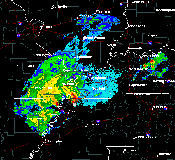 At 733 pm cdt, doppler radar indicated a severe thunderstorm producing a tornado was located near woodland mills, moving northeast at 20 mph. another potential tornado was located approximately 8 miles northeast of hornbeak (radar indicated rotation). Hazards include tornado and quarter size hail. Flying debris will be dangerous to those caught without shelter. mobile homes will be damaged or destroyed. damage to roofs, windows, and vehicles will occur. tree damage is likely. Locations impacted include, union city, clayton, woodland mills, roneys store, old fremont, fremont and crystal. At 733 pm cdt, doppler radar indicated a severe thunderstorm producing a tornado was located near woodland mills, moving northeast at 20 mph. another potential tornado was located approximately 8 miles northeast of hornbeak (radar indicated rotation). Hazards include tornado and quarter size hail. Flying debris will be dangerous to those caught without shelter. mobile homes will be damaged or destroyed. damage to roofs, windows, and vehicles will occur. tree damage is likely. Locations impacted include, union city, clayton, woodland mills, roneys store, old fremont, fremont and crystal.
|
| 5/2/2019 7:22 PM CDT |
 At 721 pm cdt, doppler radar indicated a severe thunderstorm producing a tornado was located near clayton, or 7 miles south of hickman, moving northeast at 20 mph. another potential tornado was located near hornbeak, also moving northeast at 20 mph (radar indicated rotation). Hazards include tornado and quarter size hail. Flying debris will be dangerous to those caught without shelter. mobile homes will be damaged or destroyed. damage to roofs, windows, and vehicles will occur. tree damage is likely. Locations impacted include, union city, clayton, hornbeak, woodland mills, samburg, roneys store, spout springs, lassiter corner, walnut log, old fremont, fremont and crystal. At 721 pm cdt, doppler radar indicated a severe thunderstorm producing a tornado was located near clayton, or 7 miles south of hickman, moving northeast at 20 mph. another potential tornado was located near hornbeak, also moving northeast at 20 mph (radar indicated rotation). Hazards include tornado and quarter size hail. Flying debris will be dangerous to those caught without shelter. mobile homes will be damaged or destroyed. damage to roofs, windows, and vehicles will occur. tree damage is likely. Locations impacted include, union city, clayton, hornbeak, woodland mills, samburg, roneys store, spout springs, lassiter corner, walnut log, old fremont, fremont and crystal.
|
| 5/2/2019 6:56 PM CDT |
 At 655 pm cdt, a severe thunderstorm producing a tornado was located near clayton, or 7 miles east of reelfoot lake state park, moving northeast at 20 mph (weather spotters reported funnel cloud. at 650 pm cdt, trained spotters reported a funnel cloud near samburg). Hazards include tornado and ping pong ball size hail. Flying debris will be dangerous to those caught without shelter. mobile homes will be damaged or destroyed. damage to roofs, windows, and vehicles will occur. Tree damage is likely. At 655 pm cdt, a severe thunderstorm producing a tornado was located near clayton, or 7 miles east of reelfoot lake state park, moving northeast at 20 mph (weather spotters reported funnel cloud. at 650 pm cdt, trained spotters reported a funnel cloud near samburg). Hazards include tornado and ping pong ball size hail. Flying debris will be dangerous to those caught without shelter. mobile homes will be damaged or destroyed. damage to roofs, windows, and vehicles will occur. Tree damage is likely.
|
| 7/19/2018 6:42 PM CDT |
 At 642 pm cdt, a severe thunderstorm was located near union city, moving east at 20 mph (radar indicated). Hazards include 60 mph wind gusts and quarter size hail. Hail damage to vehicles is expected. expect wind damage to roofs, siding, and trees. Locations impacted include, martin, union city, fulton, south fulton, troy, obion, sharon, woodland mills, rives, sidonia, mount pelia, old fremont, gibbs, moffatt, shaffner, wolverine, terrell, mcconnell, mccutchen heights and gardner. At 642 pm cdt, a severe thunderstorm was located near union city, moving east at 20 mph (radar indicated). Hazards include 60 mph wind gusts and quarter size hail. Hail damage to vehicles is expected. expect wind damage to roofs, siding, and trees. Locations impacted include, martin, union city, fulton, south fulton, troy, obion, sharon, woodland mills, rives, sidonia, mount pelia, old fremont, gibbs, moffatt, shaffner, wolverine, terrell, mcconnell, mccutchen heights and gardner.
|
| 7/19/2018 6:23 PM CDT |
 At 622 pm cdt, a severe thunderstorm was located near troy, or near union city, moving east at 20 mph (radar indicated). Hazards include 60 mph wind gusts and quarter size hail. Hail damage to vehicles is expected. Expect wind damage to roofs, siding, and trees. At 622 pm cdt, a severe thunderstorm was located near troy, or near union city, moving east at 20 mph (radar indicated). Hazards include 60 mph wind gusts and quarter size hail. Hail damage to vehicles is expected. Expect wind damage to roofs, siding, and trees.
|
| 6/28/2018 9:55 PM CDT |
 At 954 pm cdt, severe thunderstorms were located along a line extending from 6 miles southwest of kenton to 6 miles south of new johnsonville, moving south at 40 mph (public). Hazards include 60 mph wind gusts. expect damage to roofs, siding, and trees At 954 pm cdt, severe thunderstorms were located along a line extending from 6 miles southwest of kenton to 6 miles south of new johnsonville, moving south at 40 mph (public). Hazards include 60 mph wind gusts. expect damage to roofs, siding, and trees
|
| 6/28/2018 9:27 PM CDT |
 At 927 pm cdt, a severe thunderstorm was located near palmersville, or 14 miles east of martin, moving south at 60 mph (radar indicated). Hazards include 70 mph wind gusts and quarter size hail. Hail damage to vehicles is expected. expect considerable tree damage. Wind damage is also likely to mobile homes, roofs, and outbuildings. At 927 pm cdt, a severe thunderstorm was located near palmersville, or 14 miles east of martin, moving south at 60 mph (radar indicated). Hazards include 70 mph wind gusts and quarter size hail. Hail damage to vehicles is expected. expect considerable tree damage. Wind damage is also likely to mobile homes, roofs, and outbuildings.
|
| 6/28/2018 9:23 PM CDT | Wind gusts to 60 mph in union cit in obion county TN, 0.6 miles N of Union City, TN |
| 6/28/2018 8:59 PM CDT |
 At 842 pm cdt, severe thunderstorms were located along a line extending from near energy to 7 miles southeast of wyatt, moving south at 60 mph (radar indicated). Hazards include 60 mph wind gusts. Expect damage to roofs, siding, and trees. Locations impacted include, martin, union city, paris, caruthersville, mckenzie, fulton, paris landing state park, reelfoot lake state park, tiptonville, newbern, dresden, south fulton, dyer, greenfield, ridgely, gleason, troy, kenton, rutherford and obion. At 842 pm cdt, severe thunderstorms were located along a line extending from near energy to 7 miles southeast of wyatt, moving south at 60 mph (radar indicated). Hazards include 60 mph wind gusts. Expect damage to roofs, siding, and trees. Locations impacted include, martin, union city, paris, caruthersville, mckenzie, fulton, paris landing state park, reelfoot lake state park, tiptonville, newbern, dresden, south fulton, dyer, greenfield, ridgely, gleason, troy, kenton, rutherford and obion.
|
| 6/28/2018 8:42 PM CDT |
 At 842 pm cdt, severe thunderstorms were located along a line extending from near energy to 7 miles southeast of wyatt, moving south at 60 mph (radar indicated). Hazards include 60 mph wind gusts. Expect damage to roofs, siding, and trees. Locations impacted include, martin, union city, paris, caruthersville, mckenzie, fulton, paris landing state park, reelfoot lake state park, tiptonville, newbern, dresden, south fulton, dyer, greenfield, ridgely, gleason, troy, kenton, rutherford and obion. At 842 pm cdt, severe thunderstorms were located along a line extending from near energy to 7 miles southeast of wyatt, moving south at 60 mph (radar indicated). Hazards include 60 mph wind gusts. Expect damage to roofs, siding, and trees. Locations impacted include, martin, union city, paris, caruthersville, mckenzie, fulton, paris landing state park, reelfoot lake state park, tiptonville, newbern, dresden, south fulton, dyer, greenfield, ridgely, gleason, troy, kenton, rutherford and obion.
|
| 6/28/2018 8:36 PM CDT |
 At 836 pm cdt, severe thunderstorms were located along a line extending from energy to 7 miles north of towosahgy state historic site, moving northeast at 30 mph (radar indicated). Hazards include 60 mph wind gusts. expect damage to roofs, siding, and trees At 836 pm cdt, severe thunderstorms were located along a line extending from energy to 7 miles north of towosahgy state historic site, moving northeast at 30 mph (radar indicated). Hazards include 60 mph wind gusts. expect damage to roofs, siding, and trees
|
| 6/14/2018 11:48 PM CDT |
 At 1147 pm cdt, a severe thunderstorm was located over obion, or 12 miles southwest of union city, moving southeast at 15 mph (radar indicated). Hazards include 60 mph wind gusts and quarter size hail. Hail damage to vehicles is expected. expect wind damage to roofs, siding, and trees. Locations impacted include, union city, troy, kenton, obion, cloverdale, hornbeak, rives, mason hall, glass, gibbs, moffatt, shaffner, elbridge, wolverine, mccutchen heights, minnick and jacksonville. At 1147 pm cdt, a severe thunderstorm was located over obion, or 12 miles southwest of union city, moving southeast at 15 mph (radar indicated). Hazards include 60 mph wind gusts and quarter size hail. Hail damage to vehicles is expected. expect wind damage to roofs, siding, and trees. Locations impacted include, union city, troy, kenton, obion, cloverdale, hornbeak, rives, mason hall, glass, gibbs, moffatt, shaffner, elbridge, wolverine, mccutchen heights, minnick and jacksonville.
|
| 6/14/2018 11:12 PM CDT |
 At 1112 pm cdt, a severe thunderstorm was located near tiptonville, or 8 miles north of reelfoot lake state park, moving southeast at 15 mph (radar indicated). Hazards include 60 mph wind gusts and quarter size hail. Hail damage to vehicles is expected. Expect wind damage to roofs, siding, and trees. At 1112 pm cdt, a severe thunderstorm was located near tiptonville, or 8 miles north of reelfoot lake state park, moving southeast at 15 mph (radar indicated). Hazards include 60 mph wind gusts and quarter size hail. Hail damage to vehicles is expected. Expect wind damage to roofs, siding, and trees.
|
| 5/19/2018 4:42 PM CDT |
 At 442 pm cdt, a severe thunderstorm was located near martin, moving east at 40 mph (radar indicated). Hazards include 60 mph wind gusts and quarter size hail. Hail damage to vehicles is expected. expect wind damage to roofs, siding, and trees. Locations impacted include, martin, union city, dresden, dyer, greenfield, kenton, rutherford, bradford, sharon, latham, rives, yorkville, mason hall, grizzard, mount pelia, good luck, ralston, shaffner, terrell and currie. At 442 pm cdt, a severe thunderstorm was located near martin, moving east at 40 mph (radar indicated). Hazards include 60 mph wind gusts and quarter size hail. Hail damage to vehicles is expected. expect wind damage to roofs, siding, and trees. Locations impacted include, martin, union city, dresden, dyer, greenfield, kenton, rutherford, bradford, sharon, latham, rives, yorkville, mason hall, grizzard, mount pelia, good luck, ralston, shaffner, terrell and currie.
|
| 5/19/2018 4:31 PM CDT |
 At 431 pm cdt, a severe thunderstorm was located near kenton, or 10 miles southwest of martin, moving east at 40 mph (radar indicated). Hazards include 60 mph wind gusts and quarter size hail. Hail damage to vehicles is expected. expect wind damage to roofs, siding, and trees. Locations impacted include, dyersburg, martin, union city, newbern, dresden, dyer, greenfield, troy, kenton, rutherford, obion, bradford, sharon, latham, cloverdale, miston, trimble, hornbeak, rives and yorkville. At 431 pm cdt, a severe thunderstorm was located near kenton, or 10 miles southwest of martin, moving east at 40 mph (radar indicated). Hazards include 60 mph wind gusts and quarter size hail. Hail damage to vehicles is expected. expect wind damage to roofs, siding, and trees. Locations impacted include, dyersburg, martin, union city, newbern, dresden, dyer, greenfield, troy, kenton, rutherford, obion, bradford, sharon, latham, cloverdale, miston, trimble, hornbeak, rives and yorkville.
|
| 5/19/2018 4:08 PM CDT |
 At 407 pm cdt, a severe thunderstorm was located over cloverdale, or 10 miles southeast of reelfoot lake state park, moving east at 40 mph (radar indicated). Hazards include 60 mph wind gusts and half dollar size hail. Hail damage to vehicles is expected. Expect wind damage to roofs, siding, and trees. At 407 pm cdt, a severe thunderstorm was located over cloverdale, or 10 miles southeast of reelfoot lake state park, moving east at 40 mph (radar indicated). Hazards include 60 mph wind gusts and half dollar size hail. Hail damage to vehicles is expected. Expect wind damage to roofs, siding, and trees.
|
| 3/24/2018 6:52 PM CDT | A few trees down near claude tucker road. also... an above-ground pool flipped over onto a privacy fence in the same area. time is radar estimate in obion county TN, 4.4 miles SW of Union City, TN |
| 2/24/2018 7:03 PM CST |
 At 703 pm cst, a confirmed large and extremely dangerous tornado was located over union city, moving east at 15 mph. this is a particularly dangerous situation. take cover now! (radar confirmed tornado). Hazards include damaging tornado. You are in a life-threatening situation. flying debris may be deadly to those caught without shelter. mobile homes will be destroyed. considerable damage to homes, businesses, and vehicles is likely and complete destruction is possible. the tornado will be near, union city around 710 pm cst. fulton and south fulton around 745 pm cst. Other locations impacted by this tornadic thunderstorm include woodland mills, shaffner, brundige, terrell, mcconnell, rives, gibbs, mccutchen heights, ruthville and dukedom. At 703 pm cst, a confirmed large and extremely dangerous tornado was located over union city, moving east at 15 mph. this is a particularly dangerous situation. take cover now! (radar confirmed tornado). Hazards include damaging tornado. You are in a life-threatening situation. flying debris may be deadly to those caught without shelter. mobile homes will be destroyed. considerable damage to homes, businesses, and vehicles is likely and complete destruction is possible. the tornado will be near, union city around 710 pm cst. fulton and south fulton around 745 pm cst. Other locations impacted by this tornadic thunderstorm include woodland mills, shaffner, brundige, terrell, mcconnell, rives, gibbs, mccutchen heights, ruthville and dukedom.
|
| 2/24/2018 7:02 PM CST | Several homes damaged and power lines down. time estimated by rada in obion county TN, 2.7 miles WSW of Union City, TN |
| 2/24/2018 6:47 PM CST |
 At 647 pm cst, a severe thunderstorm producing a tornado was located near cloverdale, or 8 miles southeast of reelfoot lake state park, moving east at 60 mph (radar indicated rotation). Hazards include tornado. Flying debris will be dangerous to those caught without shelter. mobile homes will be damaged or destroyed. damage to roofs, windows, and vehicles will occur. tree damage is likely. this dangerous storm will be near, obion around 655 pm cst. troy around 700 pm cst. union city around 705 pm cst. Other locations impacted by this tornadic thunderstorm include sharps ferry, mason hall, poplar ridge, glass, gibbs, lane, moffatt, locust grove, shaffner and roneys store. At 647 pm cst, a severe thunderstorm producing a tornado was located near cloverdale, or 8 miles southeast of reelfoot lake state park, moving east at 60 mph (radar indicated rotation). Hazards include tornado. Flying debris will be dangerous to those caught without shelter. mobile homes will be damaged or destroyed. damage to roofs, windows, and vehicles will occur. tree damage is likely. this dangerous storm will be near, obion around 655 pm cst. troy around 700 pm cst. union city around 705 pm cst. Other locations impacted by this tornadic thunderstorm include sharps ferry, mason hall, poplar ridge, glass, gibbs, lane, moffatt, locust grove, shaffner and roneys store.
|
| 2/24/2018 6:46 PM CST |
 At 646 pm cst, severe thunderstorms were located along a line extending from near hickman to near halls to 6 miles south of ripley, moving east at 50 mph (radar indicated). Hazards include 60 mph wind gusts. expect damage to roofs, siding, and trees At 646 pm cst, severe thunderstorms were located along a line extending from near hickman to near halls to 6 miles south of ripley, moving east at 50 mph (radar indicated). Hazards include 60 mph wind gusts. expect damage to roofs, siding, and trees
|
| 2/24/2018 6:45 PM CST |
 At 646 pm cst, severe thunderstorms were located along a line extending from near hickman to near halls to 6 miles south of ripley, moving east at 50 mph (radar indicated). Hazards include 60 mph wind gusts. expect damage to roofs, siding, and trees At 646 pm cst, severe thunderstorms were located along a line extending from near hickman to near halls to 6 miles south of ripley, moving east at 50 mph (radar indicated). Hazards include 60 mph wind gusts. expect damage to roofs, siding, and trees
|
| 2/24/2018 6:30 PM CST |
 At 630 pm cst, a severe thunderstorm producing a tornado was located over caruthersville, moving east at 55 mph (radar indicated rotation). Hazards include tornado. Flying debris will be dangerous to those caught without shelter. mobile homes will be damaged or destroyed. damage to roofs, windows, and vehicles will occur. tree damage is likely. this dangerous storm will be near, cottonwood grove and miston around 635 pm cst. ridgely around 640 pm cst. cloverdale around 650 pm cst. obion around 655 pm cst. troy around 705 pm cst. Other locations impacted by this tornadic thunderstorm include mason hall, cat corner, wynnburg, glass, locust grove, hathaway, shaffner, roneys store, elbridge and trimble. At 630 pm cst, a severe thunderstorm producing a tornado was located over caruthersville, moving east at 55 mph (radar indicated rotation). Hazards include tornado. Flying debris will be dangerous to those caught without shelter. mobile homes will be damaged or destroyed. damage to roofs, windows, and vehicles will occur. tree damage is likely. this dangerous storm will be near, cottonwood grove and miston around 635 pm cst. ridgely around 640 pm cst. cloverdale around 650 pm cst. obion around 655 pm cst. troy around 705 pm cst. Other locations impacted by this tornadic thunderstorm include mason hall, cat corner, wynnburg, glass, locust grove, hathaway, shaffner, roneys store, elbridge and trimble.
|
| 5/27/2017 10:23 PM CDT |
 At 1023 pm cdt, a severe thunderstorm was located near cloverdale, or 10 miles north of dyersburg, moving east at 50 mph (radar indicated). Hazards include 70 mph wind gusts and quarter size hail. Hail damage to vehicles is expected. expect considerable tree damage. Wind damage is also likely to mobile homes, roofs, and outbuildings. At 1023 pm cdt, a severe thunderstorm was located near cloverdale, or 10 miles north of dyersburg, moving east at 50 mph (radar indicated). Hazards include 70 mph wind gusts and quarter size hail. Hail damage to vehicles is expected. expect considerable tree damage. Wind damage is also likely to mobile homes, roofs, and outbuildings.
|
| 5/27/2017 6:39 PM CDT |
 At 639 pm cdt, a severe thunderstorm was located over dorena, or near hickman, moving east at 55 mph (radar indicated). Hazards include 60 mph wind gusts and quarter size hail. Hail damage to vehicles is expected. Expect wind damage to roofs, siding, and trees. At 639 pm cdt, a severe thunderstorm was located over dorena, or near hickman, moving east at 55 mph (radar indicated). Hazards include 60 mph wind gusts and quarter size hail. Hail damage to vehicles is expected. Expect wind damage to roofs, siding, and trees.
|
| 4/30/2017 12:39 PM CDT |
 At 1238 pm cdt, a severe thunderstorm was located 7 miles southeast of newbern, or 9 miles east of dyersburg, moving north at 50 mph (radar indicated). Hazards include 60 mph wind gusts. expect damage to roofs, siding, and trees At 1238 pm cdt, a severe thunderstorm was located 7 miles southeast of newbern, or 9 miles east of dyersburg, moving north at 50 mph (radar indicated). Hazards include 60 mph wind gusts. expect damage to roofs, siding, and trees
|
| 4/30/2017 3:08 AM CDT | 1 inch tree limbs broken and shingles blown off roo in obion county TN, 0.5 miles E of Union City, TN |
| 4/30/2017 3:08 AM CDT |
 At 308 am cdt, a severe thunderstorm was located near obion, or 13 miles south of union city, moving east at 50 mph (radar indicated). Hazards include 60 mph wind gusts. expect damage to roofs, siding, and trees At 308 am cdt, a severe thunderstorm was located near obion, or 13 miles south of union city, moving east at 50 mph (radar indicated). Hazards include 60 mph wind gusts. expect damage to roofs, siding, and trees
|
| 4/30/2017 2:33 AM CDT |
 At 233 am cdt, a severe thunderstorm was located 7 miles northwest of cottonwood grove, or 7 miles northeast of hayti, moving east at 60 mph (radar indicated). Hazards include 60 mph wind gusts. expect damage to roofs, siding, and trees At 233 am cdt, a severe thunderstorm was located 7 miles northwest of cottonwood grove, or 7 miles northeast of hayti, moving east at 60 mph (radar indicated). Hazards include 60 mph wind gusts. expect damage to roofs, siding, and trees
|
| 3/27/2017 12:44 PM CDT |
 At 1243 pm cdt, a severe thunderstorm was located near newbern, or 7 miles east of dyersburg, moving northeast at 35 mph (radar indicated). Hazards include quarter size hail. damage to vehicles is expected At 1243 pm cdt, a severe thunderstorm was located near newbern, or 7 miles east of dyersburg, moving northeast at 35 mph (radar indicated). Hazards include quarter size hail. damage to vehicles is expected
|
| 3/9/2017 8:52 PM CST |
 At 852 pm cst, severe thunderstorms were located along a line extending from near cayce to cloverdale, moving southeast at 70 mph. brief tornadoes are possible within the fast moving line of storms (radar indicated). Hazards include 70 mph wind gusts and quarter size hail. Hail damage to vehicles is expected. expect considerable tree damage. Wind damage is also likely to mobile homes, roofs, and outbuildings. At 852 pm cst, severe thunderstorms were located along a line extending from near cayce to cloverdale, moving southeast at 70 mph. brief tornadoes are possible within the fast moving line of storms (radar indicated). Hazards include 70 mph wind gusts and quarter size hail. Hail damage to vehicles is expected. expect considerable tree damage. Wind damage is also likely to mobile homes, roofs, and outbuildings.
|
| 3/9/2017 8:26 PM CST |
 At 824 pm cst, severe thunderstorms were located along a line extending from near hunter-dawson state historic site to tiptonville to near hayti, moving east at 70 mph. brief tornadoes may also occur within the fast moving line (radar indicated). Hazards include 70 mph wind gusts and quarter size hail. Hail damage to vehicles is expected. expect considerable tree damage. wind damage is also likely to mobile homes, roofs, and outbuildings. Locations impacted include, union city, portageville, reelfoot lake state park, tiptonville, ridgely, troy, kenton, obion, wardell, clayton, bolton, cloverdale, cottonwood grove, hornbeak, woodland mills, rives, samburg, shaffner, elbridge and jacksonville. At 824 pm cst, severe thunderstorms were located along a line extending from near hunter-dawson state historic site to tiptonville to near hayti, moving east at 70 mph. brief tornadoes may also occur within the fast moving line (radar indicated). Hazards include 70 mph wind gusts and quarter size hail. Hail damage to vehicles is expected. expect considerable tree damage. wind damage is also likely to mobile homes, roofs, and outbuildings. Locations impacted include, union city, portageville, reelfoot lake state park, tiptonville, ridgely, troy, kenton, obion, wardell, clayton, bolton, cloverdale, cottonwood grove, hornbeak, woodland mills, rives, samburg, shaffner, elbridge and jacksonville.
|
| 3/9/2017 8:00 PM CST |
 At 758 pm cst, severe thunderstorms were located along a line extending from near canalou to near risco to near clarkton, moving east at 45 mph (radar indicated). Hazards include 70 mph wind gusts and quarter size hail. Hail damage to vehicles is expected. expect considerable tree damage. Wind damage is also likely to mobile homes, roofs, and outbuildings. At 758 pm cst, severe thunderstorms were located along a line extending from near canalou to near risco to near clarkton, moving east at 45 mph (radar indicated). Hazards include 70 mph wind gusts and quarter size hail. Hail damage to vehicles is expected. expect considerable tree damage. Wind damage is also likely to mobile homes, roofs, and outbuildings.
|
| 3/7/2017 4:50 AM CST |
 The severe thunderstorm warning for northwestern weakley, northeastern dyer and obion counties will expire at 500 am cst, the storms which prompted the warning have weakened below severe limits, and no longer pose an immediate threat to life or property. therefore, the warning will be allowed to expire. a severe thunderstorm watch remains in effect until noon cst for western tennessee. The severe thunderstorm warning for northwestern weakley, northeastern dyer and obion counties will expire at 500 am cst, the storms which prompted the warning have weakened below severe limits, and no longer pose an immediate threat to life or property. therefore, the warning will be allowed to expire. a severe thunderstorm watch remains in effect until noon cst for western tennessee.
|
| 3/7/2017 4:33 AM CST |
 At 432 am cst, severe thunderstorms were located along a line extending from near cloverdale to near miston, moving east at 50 mph (radar indicated). Hazards include 60 mph wind gusts. Expect damage to roofs, siding, and trees. Locations impacted include, martin, union city, fulton, dresden, south fulton, troy, obion, sharon, latham, clayton, cloverdale, miston, trimble, hornbeak, woodland mills, rives, samburg, cat corner, ralston and shaffner. At 432 am cst, severe thunderstorms were located along a line extending from near cloverdale to near miston, moving east at 50 mph (radar indicated). Hazards include 60 mph wind gusts. Expect damage to roofs, siding, and trees. Locations impacted include, martin, union city, fulton, dresden, south fulton, troy, obion, sharon, latham, clayton, cloverdale, miston, trimble, hornbeak, woodland mills, rives, samburg, cat corner, ralston and shaffner.
|
| 3/7/2017 4:12 AM CST |
 At 411 am cst, severe thunderstorms were located along a line extending from 6 miles south of marston to caruthersville, moving east at 60 mph (radar indicated). Hazards include 60 mph wind gusts. expect damage to roofs, siding, and trees At 411 am cst, severe thunderstorms were located along a line extending from 6 miles south of marston to caruthersville, moving east at 60 mph (radar indicated). Hazards include 60 mph wind gusts. expect damage to roofs, siding, and trees
|
| 3/1/2017 5:00 AM CST |
 At 500 am cst, severe thunderstorms were located along a line extending from cayce to 6 miles west of rutherford, moving east at 70 mph (radar indicated). Hazards include 70 mph wind gusts. Expect considerable tree damage. damage is likely to mobile homes, roofs, and outbuildings. locations impacted include, union city, fulton, south fulton, troy, kenton, obion, clayton, cloverdale, hornbeak, woodland mills, rives, samburg, mason hall, glass, mc connell, shaffner, roneys store, elbridge, mc cutchen heights and jacksonville. A tornado watch remains in effect until 800 am cst for western and west tennessee. At 500 am cst, severe thunderstorms were located along a line extending from cayce to 6 miles west of rutherford, moving east at 70 mph (radar indicated). Hazards include 70 mph wind gusts. Expect considerable tree damage. damage is likely to mobile homes, roofs, and outbuildings. locations impacted include, union city, fulton, south fulton, troy, kenton, obion, clayton, cloverdale, hornbeak, woodland mills, rives, samburg, mason hall, glass, mc connell, shaffner, roneys store, elbridge, mc cutchen heights and jacksonville. A tornado watch remains in effect until 800 am cst for western and west tennessee.
|
| 3/1/2017 4:36 AM CST |
 At 435 am cst, severe thunderstorms were located along a line extending from new madrid to near caruthersville, moving east at 70 mph (radar indicated). Hazards include 70 mph wind gusts. Expect considerable tree damage. Damage is likely to mobile homes, roofs, and outbuildings. At 435 am cst, severe thunderstorms were located along a line extending from new madrid to near caruthersville, moving east at 70 mph (radar indicated). Hazards include 70 mph wind gusts. Expect considerable tree damage. Damage is likely to mobile homes, roofs, and outbuildings.
|
| 12/17/2016 5:30 PM CST |
 At 530 pm cst, a severe thunderstorm was located near clayton, or near hickman, moving northeast at 60 mph (radar indicated). Hazards include 60 mph wind gusts. Expect damage to roofs, siding, and trees. locations impacted include, union city, troy, obion, clayton, hornbeak, woodland mills, rives, samburg, fremont, lassiter corner, minnick, walnut log, moffatt, shaffner, mc cutchen heights, spout springs, gratio, jacksonville, old fremont and crystal. A tornado watch remains in effect until 900 pm cst for western tennessee. At 530 pm cst, a severe thunderstorm was located near clayton, or near hickman, moving northeast at 60 mph (radar indicated). Hazards include 60 mph wind gusts. Expect damage to roofs, siding, and trees. locations impacted include, union city, troy, obion, clayton, hornbeak, woodland mills, rives, samburg, fremont, lassiter corner, minnick, walnut log, moffatt, shaffner, mc cutchen heights, spout springs, gratio, jacksonville, old fremont and crystal. A tornado watch remains in effect until 900 pm cst for western tennessee.
|
| 12/17/2016 5:04 PM CST |
 At 504 pm cst, a severe thunderstorm was located near portageville, moving northeast at 60 mph (radar indicated). Hazards include 60 mph wind gusts. expect damage to roofs, siding, and trees At 504 pm cst, a severe thunderstorm was located near portageville, moving northeast at 60 mph (radar indicated). Hazards include 60 mph wind gusts. expect damage to roofs, siding, and trees
|
| 8/14/2016 6:36 PM CDT |
 At 635 pm cdt, a severe thunderstorm was located near martin, moving north at 30 mph (radar indicated). Hazards include 60 mph wind gusts. Expect damage to roofs. siding. and trees. Locations impacted include, martin, union city, fulton, south fulton, rives, gardner, terrell, mc connell, shaffner, mc cutchen heights, mount pelia, ruthville, gibbs and ralston. At 635 pm cdt, a severe thunderstorm was located near martin, moving north at 30 mph (radar indicated). Hazards include 60 mph wind gusts. Expect damage to roofs. siding. and trees. Locations impacted include, martin, union city, fulton, south fulton, rives, gardner, terrell, mc connell, shaffner, mc cutchen heights, mount pelia, ruthville, gibbs and ralston.
|
| 8/14/2016 6:20 PM CDT |
 At 619 pm cdt, a severe thunderstorm was located near martin, moving north at 40 mph (radar indicated). Hazards include 60 mph wind gusts. Expect damage to roofs. siding. And trees. At 619 pm cdt, a severe thunderstorm was located near martin, moving north at 40 mph (radar indicated). Hazards include 60 mph wind gusts. Expect damage to roofs. siding. And trees.
|
| 8/5/2016 6:40 PM CDT | Trees down and power lines likely down causing power outages in small community of dixi in obion county TN, 3.3 miles E of Union City, TN |
| 6/21/2016 2:42 PM CDT | The severe thunderstorm warning for northwestern weakley and northeastern obion counties will expire at 245 pm cdt, the storm which prompted the warning has weakened below severe limits, and no longer poses an immediate threat to life or property. therefore the warning will be allowed to expire. |
| 6/21/2016 2:08 PM CDT |
 At 207 pm cdt, a severe thunderstorm was located near cayce, or near union city, moving east at 10 mph (radar indicated). Hazards include 60 mph wind gusts and quarter size hail. Hail damage to vehicles is expected. Expect wind damage to roofs, siding, and trees. At 207 pm cdt, a severe thunderstorm was located near cayce, or near union city, moving east at 10 mph (radar indicated). Hazards include 60 mph wind gusts and quarter size hail. Hail damage to vehicles is expected. Expect wind damage to roofs, siding, and trees.
|
| 6/15/2016 4:50 PM CDT | Many trees reported down in obion count in obion county TN, 0.6 miles N of Union City, TN |
| 6/15/2016 4:34 PM CDT |
 At 434 pm cdt, a severe thunderstorm was located near martin, moving east at 20 mph (radar indicated). Hazards include 60 mph wind gusts and quarter size hail. Hail damage to vehicles is expected. expect wind damage to roofs, siding, and trees. Locations impacted include, union city, fulton, reelfoot lake state park, tiptonville, south fulton, troy, kenton, obion, clayton, hornbeak, woodland mills, rives, samburg, elbridge, blue bank, moffatt, mc cutchen heights, spout springs, wynnburg and old fremont. At 434 pm cdt, a severe thunderstorm was located near martin, moving east at 20 mph (radar indicated). Hazards include 60 mph wind gusts and quarter size hail. Hail damage to vehicles is expected. expect wind damage to roofs, siding, and trees. Locations impacted include, union city, fulton, reelfoot lake state park, tiptonville, south fulton, troy, kenton, obion, clayton, hornbeak, woodland mills, rives, samburg, elbridge, blue bank, moffatt, mc cutchen heights, spout springs, wynnburg and old fremont.
|
| 6/15/2016 3:54 PM CDT |
 At 354 pm cdt, a severe thunderstorm was located near troy, or near union city, moving east at 20 mph (radar indicated). Hazards include 60 mph wind gusts and quarter size hail. Hail damage to vehicles is expected. Expect wind damage to roofs, siding, and trees. At 354 pm cdt, a severe thunderstorm was located near troy, or near union city, moving east at 20 mph (radar indicated). Hazards include 60 mph wind gusts and quarter size hail. Hail damage to vehicles is expected. Expect wind damage to roofs, siding, and trees.
|
| 6/15/2016 3:52 PM CDT | Trees down all over the ken-tenn hwy in union city and west hwy 22 and shawtown rd in obion county TN, 0.6 miles N of Union City, TN |
| 6/15/2016 3:41 PM CDT |
 At 340 pm cdt, a severe thunderstorm was located over south fulton, or over fulton, moving east at 20 mph (radar indicated). Hazards include 60 mph wind gusts and quarter size hail. Hail damage to vehicles is expected. expect wind damage to roofs, siding, and trees. Locations impacted include, martin, union city, fulton, reelfoot lake state park, tiptonville, dresden, south fulton, greenfield, ridgely, troy, kenton, obion, sharon, latham, cottonwood grove, clayton, cloverdale, trimble, hornbeak and woodland mills. At 340 pm cdt, a severe thunderstorm was located over south fulton, or over fulton, moving east at 20 mph (radar indicated). Hazards include 60 mph wind gusts and quarter size hail. Hail damage to vehicles is expected. expect wind damage to roofs, siding, and trees. Locations impacted include, martin, union city, fulton, reelfoot lake state park, tiptonville, dresden, south fulton, greenfield, ridgely, troy, kenton, obion, sharon, latham, cottonwood grove, clayton, cloverdale, trimble, hornbeak and woodland mills.
|
| 6/15/2016 2:54 PM CDT |
 At 253 pm cdt, a severe thunderstorm was located over hickman, moving east southeast at 20 mph (radar indicated). Hazards include 60 mph wind gusts and quarter size hail. Hail damage to vehicles is expected. Expect wind damage to roofs, siding, and trees. At 253 pm cdt, a severe thunderstorm was located over hickman, moving east southeast at 20 mph (radar indicated). Hazards include 60 mph wind gusts and quarter size hail. Hail damage to vehicles is expected. Expect wind damage to roofs, siding, and trees.
|
| 6/15/2016 2:49 PM CDT |
 At 249 pm cdt, a severe thunderstorm was located near cayce, or near clinton, moving east at 30 mph (radar indicated). Hazards include 60 mph wind gusts and quarter size hail. Hail damage to vehicles is expected. expect wind damage to roofs, siding, and trees. Locations impacted include, martin, union city, fulton, south fulton, clayton, woodland mills, fremont, new markham, wright, walnut log, terrell, mc connell, shaffner, spout springs, cates, proctor city, old fremont, crystal, cronanville and bessie. At 249 pm cdt, a severe thunderstorm was located near cayce, or near clinton, moving east at 30 mph (radar indicated). Hazards include 60 mph wind gusts and quarter size hail. Hail damage to vehicles is expected. expect wind damage to roofs, siding, and trees. Locations impacted include, martin, union city, fulton, south fulton, clayton, woodland mills, fremont, new markham, wright, walnut log, terrell, mc connell, shaffner, spout springs, cates, proctor city, old fremont, crystal, cronanville and bessie.
|
| 6/15/2016 2:31 PM CDT |
 At 231 pm cdt, a severe thunderstorm was located near hickman, moving east at 30 mph (radar indicated). Hazards include 60 mph wind gusts and quarter size hail. Hail damage to vehicles is expected. Expect wind damage to roofs, siding, and trees. At 231 pm cdt, a severe thunderstorm was located near hickman, moving east at 30 mph (radar indicated). Hazards include 60 mph wind gusts and quarter size hail. Hail damage to vehicles is expected. Expect wind damage to roofs, siding, and trees.
|
| 12/23/2015 2:21 PM CST | At 220 pm cst, a severe thunderstorm was located near tiptonville, or near portageville, moving northeast at 60 mph (radar indicated. at 210 pm law enforcement reported 60mph winds and golfball size hail near i-55 at the portageville exit). Hazards include golf ball size hail and 60 mph wind gusts. People and animals outdoors will be injured. expect hail damage to roofs, siding, windows and vehicles. expect wind damage to roofs, siding and trees. this severe storm will be near, reelfoot lake state park around 225 pm cst. other locations impacted by this severe thunderstorm include fremont, woodland mills, haynes, lassiter corner, new markham, blue bank, wright, mooring, walnut log and stewart. A tornado watch remains in effect until 500 pm cst for southeastern missouri and western tennessee. |
| 12/23/2015 2:21 PM CST | At 220 pm cst, a severe thunderstorm was located near tiptonville, or near portageville, moving northeast at 60 mph (radar indicated. at 210 pm law enforcement reported 60mph winds and golfball size hail near i-55 at the portageville exit). Hazards include golf ball size hail and 60 mph wind gusts. People and animals outdoors will be injured. expect hail damage to roofs, siding, windows and vehicles. expect wind damage to roofs, siding and trees. this severe storm will be near, reelfoot lake state park around 225 pm cst. other locations impacted by this severe thunderstorm include fremont, woodland mills, haynes, lassiter corner, new markham, blue bank, wright, mooring, walnut log and stewart. A tornado watch remains in effect until 500 pm cst for southeastern missouri and western tennessee. |
| 12/23/2015 2:04 PM CST | At 204 pm cst, a severe thunderstorm was located over hayti heights, or near hayti, moving northeast at 60 mph (radar indicated). Hazards include 60 mph wind gusts and quarter size hail. Hail damage to vehicles is expected. expect wind damage to roofs, siding and trees. this severe thunderstorm will be near, portageville around 215 pm cst. reelfoot lake state park and tiptonville around 225 pm cst. clayton around 235 pm cst. other locations impacted by this severe thunderstorm include woodland mills, blue bank, stubtown, spout springs, hayward, wynnburg, old fremont, hathaway, stanley and grays camp. A tornado watch remains in effect until 500 pm cst for southeastern missouri and western tennessee. |
| 12/23/2015 2:04 PM CST | At 204 pm cst, a severe thunderstorm was located over hayti heights, or near hayti, moving northeast at 60 mph (radar indicated). Hazards include 60 mph wind gusts and quarter size hail. Hail damage to vehicles is expected. expect wind damage to roofs, siding and trees. this severe thunderstorm will be near, portageville around 215 pm cst. reelfoot lake state park and tiptonville around 225 pm cst. clayton around 235 pm cst. other locations impacted by this severe thunderstorm include woodland mills, blue bank, stubtown, spout springs, hayward, wynnburg, old fremont, hathaway, stanley and grays camp. A tornado watch remains in effect until 500 pm cst for southeastern missouri and western tennessee. |
| 8/10/2015 4:50 AM CDT |
 The severe thunderstorm warning for henry, western carroll, weakley, eastern obion and central gibson counties will expire at 500 am cdt, the storm which prompted the warning has weakened below severe limits, and no longer poses an immediate threat to life or property. therefore the warning will be allowed to expire. however gusty winds are still possible with this thunderstorm. The severe thunderstorm warning for henry, western carroll, weakley, eastern obion and central gibson counties will expire at 500 am cdt, the storm which prompted the warning has weakened below severe limits, and no longer poses an immediate threat to life or property. therefore the warning will be allowed to expire. however gusty winds are still possible with this thunderstorm.
|
| 8/10/2015 4:14 AM CDT |
 At 413 am cdt, a severe thunderstorm was located over martin, moving southeast at 40 mph (radar indicated). Hazards include 60 mph wind gusts. Expect damage to roofs. Siding and trees. At 413 am cdt, a severe thunderstorm was located over martin, moving southeast at 40 mph (radar indicated). Hazards include 60 mph wind gusts. Expect damage to roofs. Siding and trees.
|
| 8/10/2015 3:37 AM CDT |
 At 336 am cdt, a severe thunderstorm was located over troy, or 8 miles southwest of union city, moving southeast at 50 mph (radar indicated). Hazards include 60 mph wind gusts. Expect damage to roofs. Siding and trees. At 336 am cdt, a severe thunderstorm was located over troy, or 8 miles southwest of union city, moving southeast at 50 mph (radar indicated). Hazards include 60 mph wind gusts. Expect damage to roofs. Siding and trees.
|
| 8/10/2015 3:26 AM CDT |
 At 326 am cdt, a severe thunderstorm was located near reelfoot lake state park, moving southeast at 50 mph (radar indicated). Hazards include 60 mph wind gusts. Expect damage to roofs. siding and trees. Locations impacted include, union city, caruthersville, hayti, fulton, reelfoot lake state park, tiptonville, ridgely, troy, obion, hayti heights, wardell, cottonwood grove, heloise, clayton, deering, miston, cloverdale, bolton, hornbeak and woodland mills. At 326 am cdt, a severe thunderstorm was located near reelfoot lake state park, moving southeast at 50 mph (radar indicated). Hazards include 60 mph wind gusts. Expect damage to roofs. siding and trees. Locations impacted include, union city, caruthersville, hayti, fulton, reelfoot lake state park, tiptonville, ridgely, troy, obion, hayti heights, wardell, cottonwood grove, heloise, clayton, deering, miston, cloverdale, bolton, hornbeak and woodland mills.
|
| 8/10/2015 2:58 AM CDT |
 At 257 am cdt, a severe thunderstorm was located over lilbourn, moving southeast at 50 mph (radar indicated). Hazards include 60 mph wind gusts. Expect damage to roofs. Siding and trees. At 257 am cdt, a severe thunderstorm was located over lilbourn, moving southeast at 50 mph (radar indicated). Hazards include 60 mph wind gusts. Expect damage to roofs. Siding and trees.
|
| 7/7/2015 2:37 AM CDT | Trees down in union city...report relayed by nws paduca in obion county TN, 0.6 miles N of Union City, TN |
| 7/1/2015 11:18 PM CDT |
 At 1117 pm cdt, a severe thunderstorm was located near union city, moving southeast at 10 mph (radar indicated). Hazards include 60 mph wind gusts and quarter size hail. Hail damage to vehicles is expected. expect wind damage to roofs, siding and trees. Locations impacted include, union city, troy, woodland mills, rives, fremont, gardner, terrell, moffatt, mc connell, shaffner, mc cutchen heights, mount pelia, old fremont, crystal and gibbs. At 1117 pm cdt, a severe thunderstorm was located near union city, moving southeast at 10 mph (radar indicated). Hazards include 60 mph wind gusts and quarter size hail. Hail damage to vehicles is expected. expect wind damage to roofs, siding and trees. Locations impacted include, union city, troy, woodland mills, rives, fremont, gardner, terrell, moffatt, mc connell, shaffner, mc cutchen heights, mount pelia, old fremont, crystal and gibbs.
|
| 7/1/2015 10:55 PM CDT |
 At 1055 pm cdt, a severe thunderstorm was located near clayton, or 10 miles northwest of union city, moving southeast at 15 mph (radar indicated). Hazards include 60 mph wind gusts and quarter size hail. Hail damage to vehicles is expected. Expect wind damage to roofs, siding and trees. At 1055 pm cdt, a severe thunderstorm was located near clayton, or 10 miles northwest of union city, moving southeast at 15 mph (radar indicated). Hazards include 60 mph wind gusts and quarter size hail. Hail damage to vehicles is expected. Expect wind damage to roofs, siding and trees.
|
| 7/1/2015 10:51 PM CDT |
 At 1050 pm cdt, a severe thunderstorm was located near union city, moving southeast at 15 mph (radar indicated). Hazards include 60 mph wind gusts and quarter size hail. Hail damage to vehicles is expected. expect wind damage to roofs, siding and trees. Locations impacted include, union city, troy, kenton, rives, mount pelia, moffatt, mc cutchen heights, sidonia and gibbs. At 1050 pm cdt, a severe thunderstorm was located near union city, moving southeast at 15 mph (radar indicated). Hazards include 60 mph wind gusts and quarter size hail. Hail damage to vehicles is expected. expect wind damage to roofs, siding and trees. Locations impacted include, union city, troy, kenton, rives, mount pelia, moffatt, mc cutchen heights, sidonia and gibbs.
|
| 7/1/2015 10:45 PM CDT | Trees and powerlines down around the city...time estimated based on radar and report in obion county TN, 0.6 miles N of Union City, TN |
| 7/1/2015 10:38 PM CDT |
 At 1038 pm cdt, a severe thunderstorm was located near union city, moving southeast at 30 mph (radar indicated). Hazards include 60 mph wind gusts and quarter size hail. Hail damage to vehicles is expected. expect wind damage to roofs, siding and trees. Locations impacted include, union city, dyer, greenfield, troy, kenton, rutherford, obion, rives, yorkville, currie, tyson store, moffatt, mc cutchen heights, sidonia, mount pelia, tilghman, wolverine, kimery, mason hall and gibbs. At 1038 pm cdt, a severe thunderstorm was located near union city, moving southeast at 30 mph (radar indicated). Hazards include 60 mph wind gusts and quarter size hail. Hail damage to vehicles is expected. expect wind damage to roofs, siding and trees. Locations impacted include, union city, dyer, greenfield, troy, kenton, rutherford, obion, rives, yorkville, currie, tyson store, moffatt, mc cutchen heights, sidonia, mount pelia, tilghman, wolverine, kimery, mason hall and gibbs.
|
| 7/1/2015 10:25 PM CDT |
 At 1024 pm cdt, a severe thunderstorm was located near clayton, or near union city, moving southeast at 30 mph (radar indicated). Hazards include 60 mph wind gusts and quarter size hail. Hail damage to vehicles is expected. Expect wind damage to roofs, siding and trees. At 1024 pm cdt, a severe thunderstorm was located near clayton, or near union city, moving southeast at 30 mph (radar indicated). Hazards include 60 mph wind gusts and quarter size hail. Hail damage to vehicles is expected. Expect wind damage to roofs, siding and trees.
|
| 5/30/2015 12:47 PM CDT | At 1246 pm cdt, a severe thunderstorm was located near clayton, or 7 miles northeast of reelfoot lake state park, moving northeast at 25 mph (radar indicated). Hazards include 60 mph wind gusts and penny size hail. Expect damage to roofs. siding and trees. Locations impacted include, martin, union city, south fulton, troy, obion, clayton, hornbeak, woodland mills, rives, samburg, elbridge, pisgah, moffatt, mc cutchen heights, spout springs, gratio, mount pelia, old fremont, wolverine and ruthville. |
| 5/30/2015 12:33 PM CDT | At 1232 pm cdt, a severe thunderstorm was located over reelfoot lake state park, moving northeast at 25 mph (radar indicated). Hazards include 60 mph wind gusts and penny size hail. Expect damage to roofs. Siding and trees. |
| 4/19/2015 9:55 PM CDT | The severe thunderstorm warning for obion county will expire at 1000 pm cdt, the storm which prompted the warning has weakened below severe limits, and no longer pose an immediate threat to life or property. therefore the warning will be allowed to expire. a tornado watch remains in effect until 300 am cdt for northwestern tennessee. |
| 4/19/2015 9:49 PM CDT | At 949 pm cdt, a severe thunderstorm was located near troy, or 8 miles west of union city, moving east at 40 mph (radar indicated). Hazards include 60 mph wind gusts. Expect damage to roofs. siding and trees. locations impacted include, union city, troy, kenton, obion, cloverdale, clayton, hornbeak, woodland mills, rives, samburg, elbridge, moffatt, mc cutchen heights, spout springs, old fremont, wolverine, fremont, lassiter corner, minnick and walnut log. a tornado watch remains in effect until 300 am cdt for northwestern tennessee. 75in. |
| 4/19/2015 9:10 PM CDT | At 910 pm cdt, a severe thunderstorm was located 7 miles northeast of hayti, moving east at 40 mph (radar indicated). Hazards include 60 mph wind gusts. Expect damage to roofs. Siding and trees. |
| 6/7/2014 4:05 PM CDT | Golf Ball sized hail reported 0.6 miles N of Union City, TN, hail started as quarter sized then rapidly increased to golfball size. |
| 6/7/2014 3:50 PM CDT | Numerous trees and power lines dow in obion county TN, 0.6 miles N of Union City, TN |
| 4/28/2014 5:15 PM CDT | North of highway 51 bypass near kentucky border and behind goodyear tire plant.farm shed destroyed. several homes with roof and siding damage. several trees dow in obion county TN, 0.8 miles S of Union City, TN |
| 6/11/2012 2:54 PM CDT | Large tree limbs down...1 tree uprooted on the north side of union city. winds estimated at greater than 60 mp in obion county TN, 0.6 miles N of Union City, TN |
| 1/1/0001 12:00 AM | Tree down on nailing drive in obion county TN, 0.6 miles N of Union City, TN |
| 1/1/0001 12:00 AM | Possible tornado damage. swath of damage from troy to union city including multiple trees in obion county TN, 0.6 miles N of Union City, TN |
| 1/1/0001 12:00 AM | Golf Ball sized hail reported 0.6 miles N of Union City, TN |
| 1/1/0001 12:00 AM | Trees down...flag pole broken...strong winds and heavy rain lasted about 10 minutes. some minor street floodin in obion county TN, 0.6 miles N of Union City, TN |
| 1/1/0001 12:00 AM | Possible tornado damage. swath of damage from troy to union city including multiple trees in obion county TN, 0.6 miles N of Union City, TN |
| 1/1/0001 12:00 AM | Storm damage reported in obion county TN, 0.6 miles N of Union City, TN |
| 1/1/0001 12:00 AM | Quarter sized hail reported 0.6 miles N of Union City, TN, quarter size hail reported by ham radio operator in union city. |
| 1/1/0001 12:00 AM | Trees down on glass road and south bluff road in obion county TN, 0.6 miles N of Union City, TN |
Hail Maps for Union City, TN


Connect with Interactive Hail Maps