

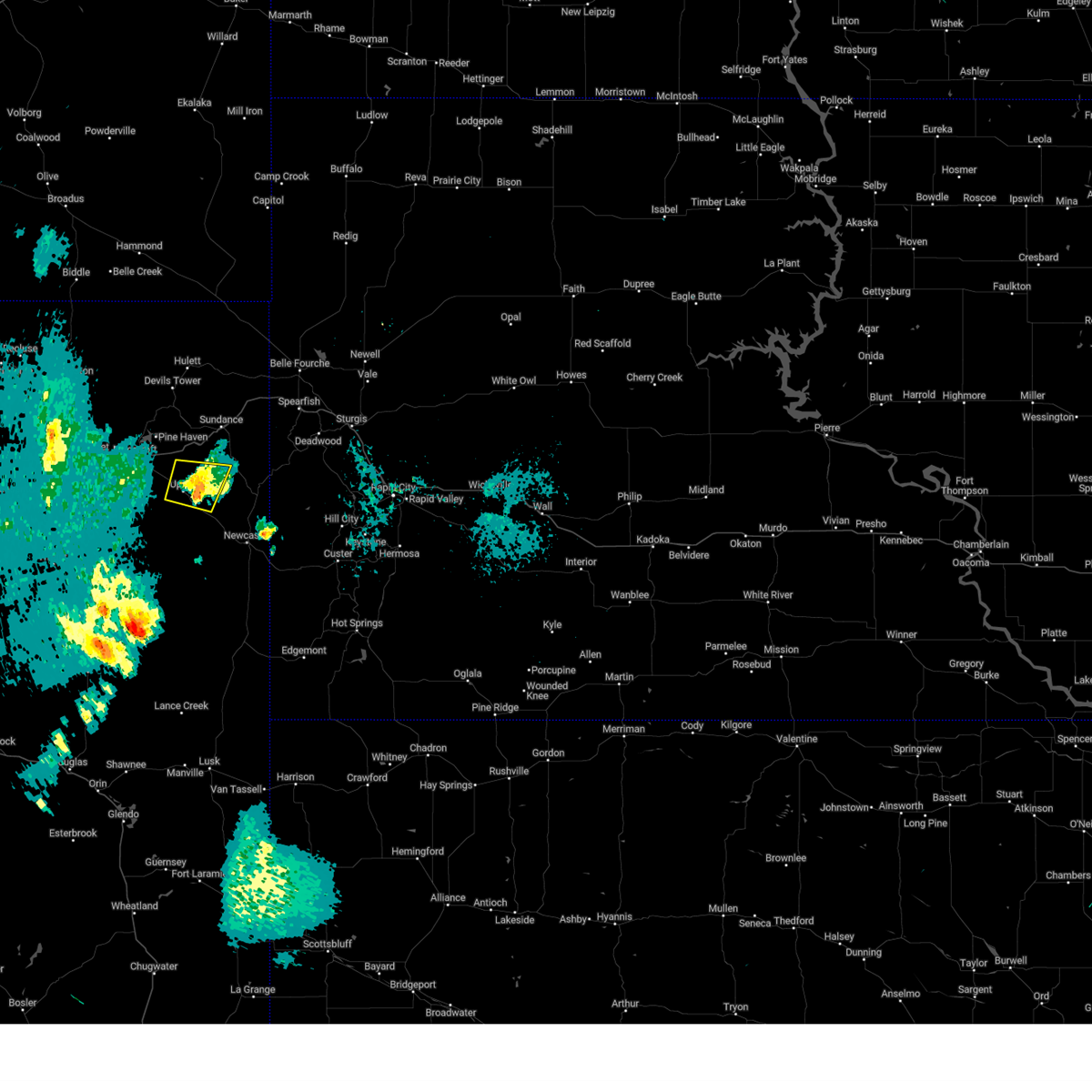
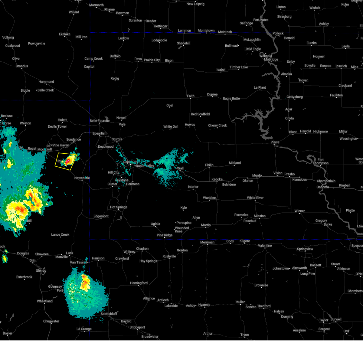
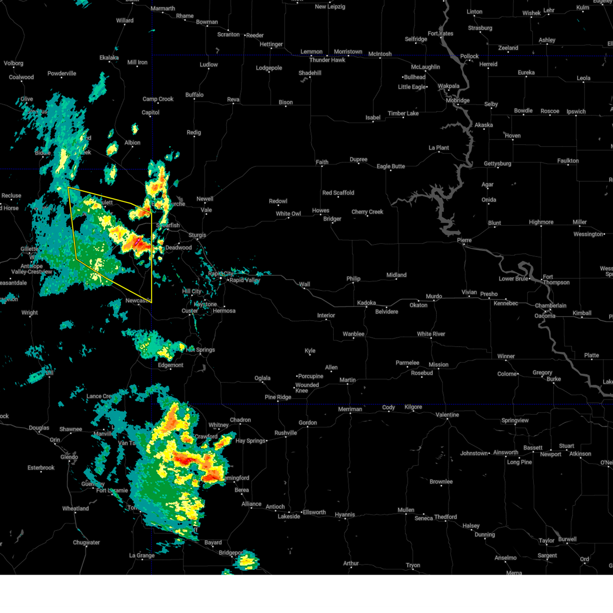
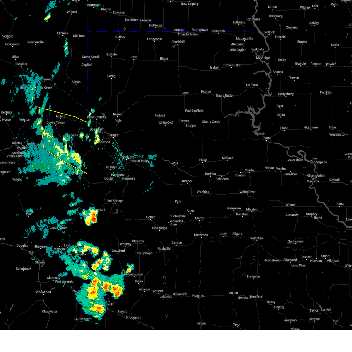
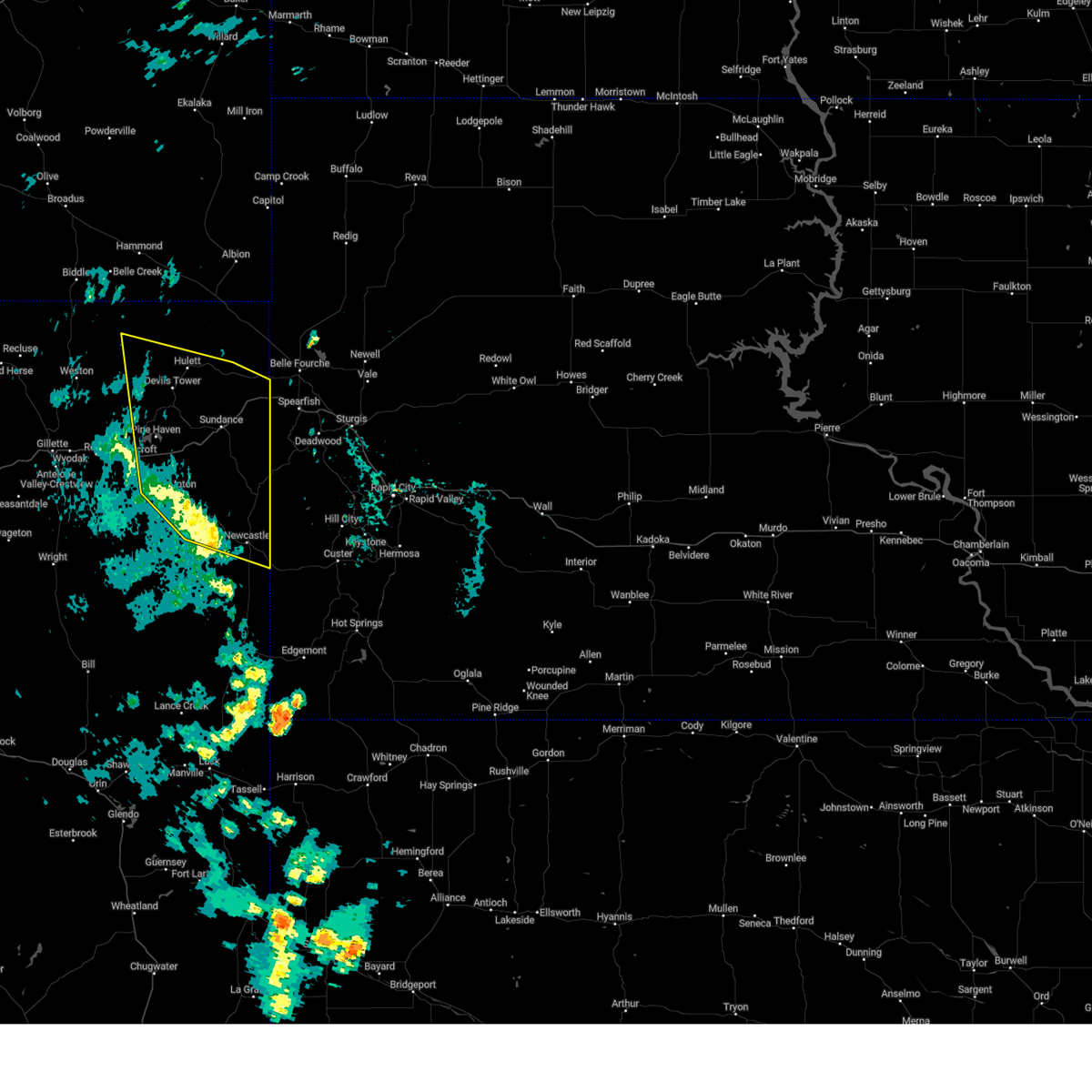
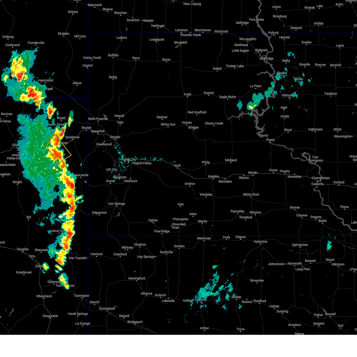
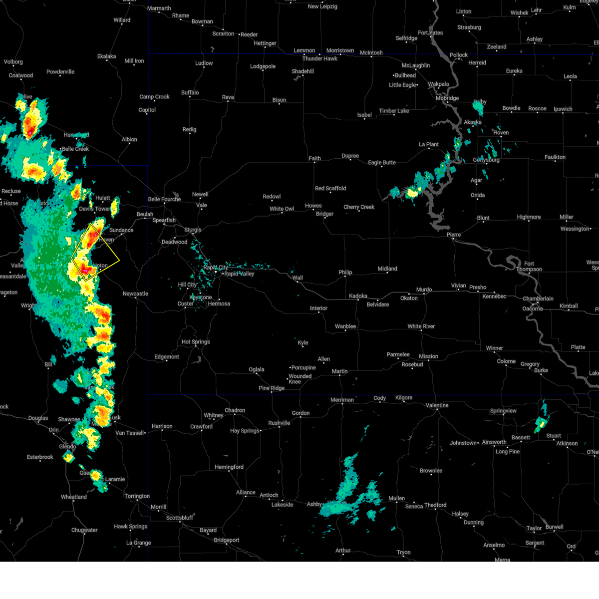
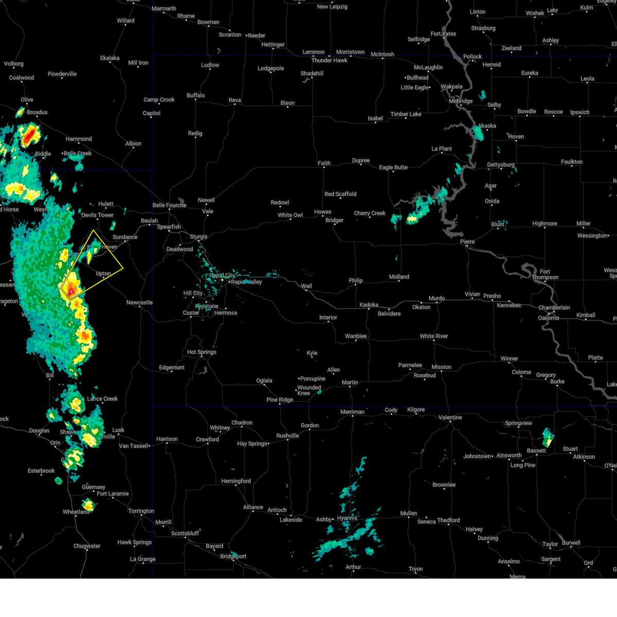
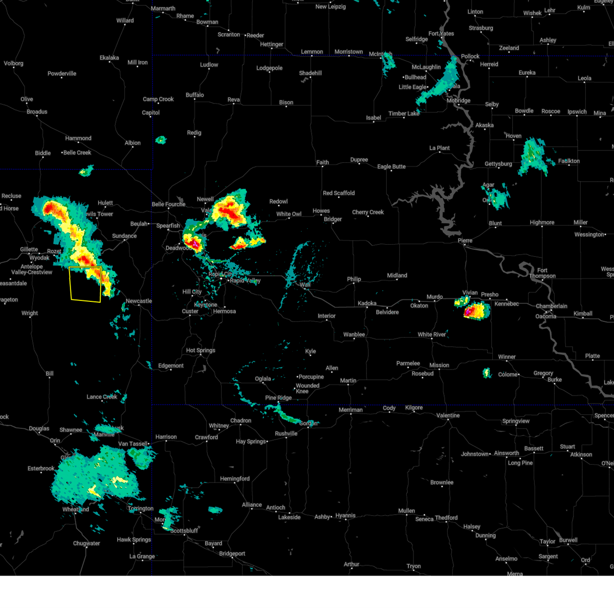
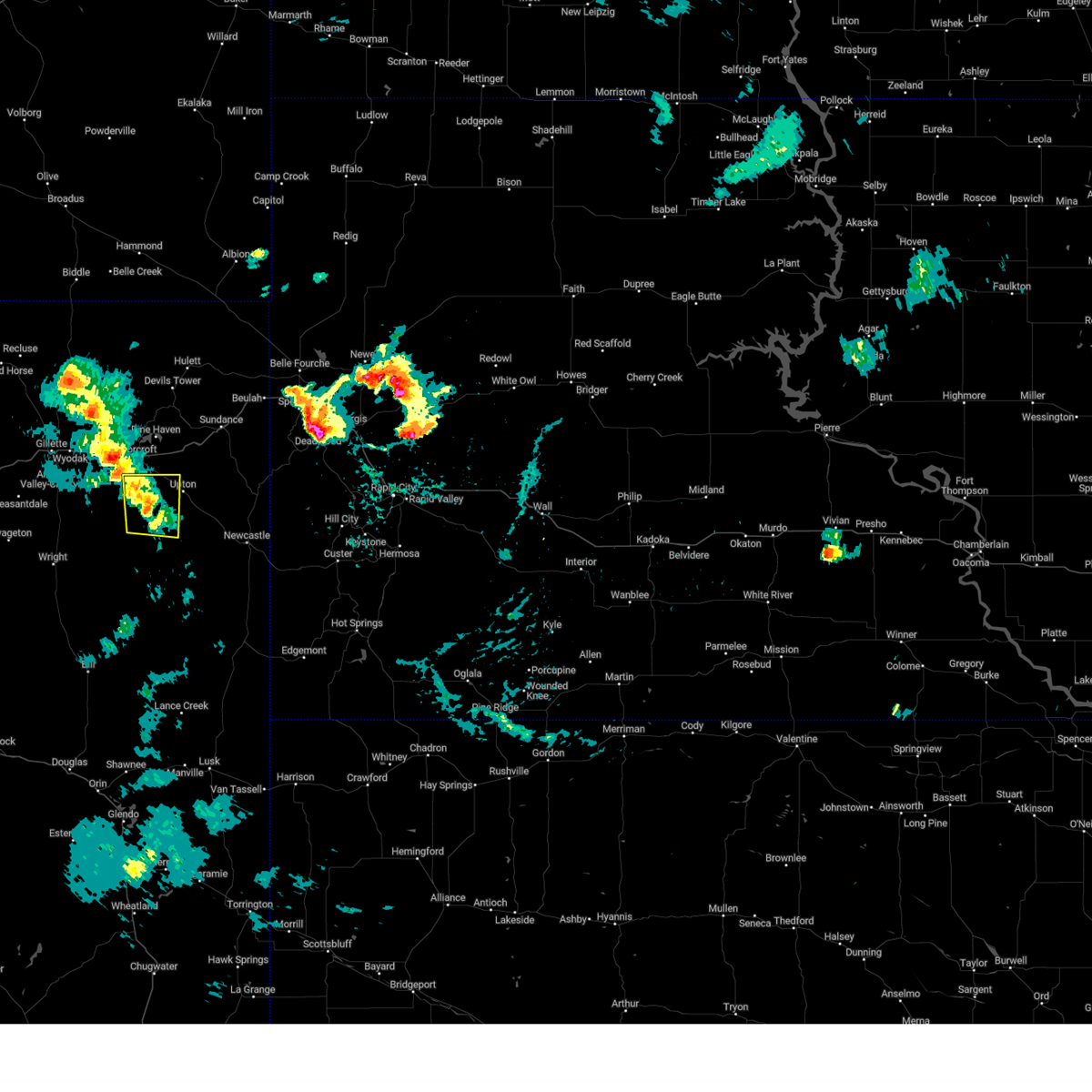
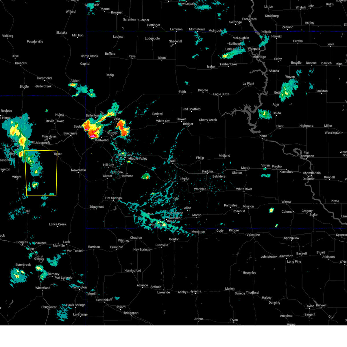
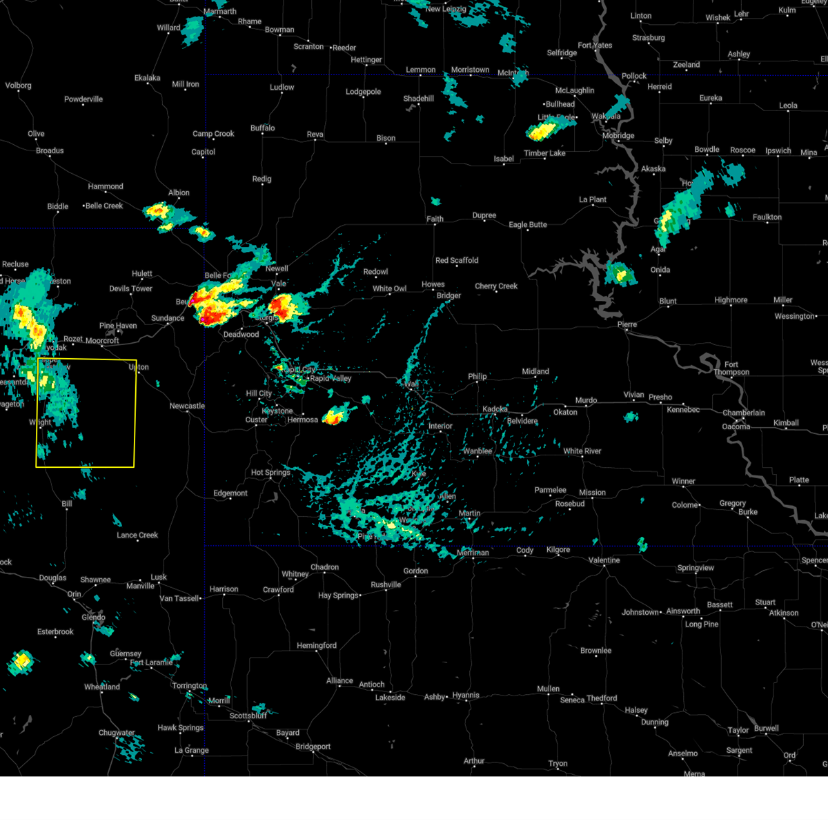
Hail Map for Upton, WY
The Upton, WY area has had 37 reports of on-the-ground hail by trained spotters, and has been under severe weather warnings 16 times during the past 12 months. Doppler radar has detected hail at or near Upton, WY on 71 occasions, including 5 occasions during the past year.
| Name: | Upton, WY |
| Where Located: | 45.7 miles ESE of Gillette, WY |
| Map: | Google Map for Upton, WY |
| Population: | 1100 |
| Housing Units: | 539 |
| More Info: | Search Google for Upton, WY |
1
The Top Recent Hail Date for Upton, WY is Sunday, September 15, 2024 (16th out of 71)

Hail and Wind Damage Spotted near Upton, WY
| Date / Time | Report Details |
|---|---|
| 6/25/2025 5:23 PM MDT | Quarter sized hail reported 10.9 miles SSW of Upton, WY |
| 6/16/2025 10:06 PM MDT | Storm damage reported in weston county WY, 9.8 miles N of Upton, WY |
| 6/1/2025 9:06 PM MDT |
 the severe thunderstorm warning has been cancelled and is no longer in effect the severe thunderstorm warning has been cancelled and is no longer in effect
|
| 6/1/2025 8:39 PM MDT |
 Svrunr the national weather service in rapid city has issued a * severe thunderstorm warning for, north central weston county in northeastern wyoming, south central crook county in northeastern wyoming, * until 945 pm mdt. * at 839 pm mdt, a severe thunderstorm was located 5 miles east of upton, or 20 miles south of sundance, moving west at 10 mph (radar indicated). Hazards include 60 mph wind gusts and half dollar size hail. Hail damage to vehicles is expected. Expect wind damage to roofs, siding, and trees. Svrunr the national weather service in rapid city has issued a * severe thunderstorm warning for, north central weston county in northeastern wyoming, south central crook county in northeastern wyoming, * until 945 pm mdt. * at 839 pm mdt, a severe thunderstorm was located 5 miles east of upton, or 20 miles south of sundance, moving west at 10 mph (radar indicated). Hazards include 60 mph wind gusts and half dollar size hail. Hail damage to vehicles is expected. Expect wind damage to roofs, siding, and trees.
|
| 9/17/2024 5:42 PM MDT |
 The storms which prompted the warning have weakened below severe limits and are exiting the warned area. therefore, the warning will be allowed to expire. however, gusty winds and heavy rain are still possible with these thunderstorms. The storms which prompted the warning have weakened below severe limits and are exiting the warned area. therefore, the warning will be allowed to expire. however, gusty winds and heavy rain are still possible with these thunderstorms.
|
| 9/17/2024 5:13 PM MDT |
 At 512 pm mdt, severe thunderstorms were located along a line extending from 6 miles southwest of carlile to 7 miles southwest of sundance to 6 miles southeast of inyan kara mountain, moving north at 50 mph. trained weather spotters and automated observations recently reported wind gusts of 60 mph near osage and southwest of upton (trained weather spotters). Hazards include 60 mph wind gusts. Expect damage to roofs, siding, and trees. locations impacted include, sundance, upton, pine haven, hulett, beulah, alva, aladdin, carlile, moskee, oshoto, new haven, four corners, buckhorn, cement ridge lookout, devils tower national monument, warren peak, inyan kara mountain, bear lodge campground, mallo camp, and cook lake. This includes interstate 90 in wyoming between mile markers 155 and 207. At 512 pm mdt, severe thunderstorms were located along a line extending from 6 miles southwest of carlile to 7 miles southwest of sundance to 6 miles southeast of inyan kara mountain, moving north at 50 mph. trained weather spotters and automated observations recently reported wind gusts of 60 mph near osage and southwest of upton (trained weather spotters). Hazards include 60 mph wind gusts. Expect damage to roofs, siding, and trees. locations impacted include, sundance, upton, pine haven, hulett, beulah, alva, aladdin, carlile, moskee, oshoto, new haven, four corners, buckhorn, cement ridge lookout, devils tower national monument, warren peak, inyan kara mountain, bear lodge campground, mallo camp, and cook lake. This includes interstate 90 in wyoming between mile markers 155 and 207.
|
| 9/17/2024 5:03 PM MDT | Storm damage reported in weston county WY, 14.4 miles WNW of Upton, WY |
| 9/17/2024 4:50 PM MDT | Storm damage reported in weston county WY, 10.2 miles ENE of Upton, WY |
| 9/17/2024 4:47 PM MDT |
 Svrunr the national weather service in rapid city has issued a * severe thunderstorm warning for, northeastern weston county in northeastern wyoming, crook county in northeastern wyoming, * until 545 pm mdt. * at 447 pm mdt, severe thunderstorms were located along a line extending from 8 miles west of upton to 6 miles northwest of osage to 8 miles west of newcastle, moving north at 45 mph (radar indicated). Hazards include 60 mph wind gusts. expect damage to roofs, siding, and trees Svrunr the national weather service in rapid city has issued a * severe thunderstorm warning for, northeastern weston county in northeastern wyoming, crook county in northeastern wyoming, * until 545 pm mdt. * at 447 pm mdt, severe thunderstorms were located along a line extending from 8 miles west of upton to 6 miles northwest of osage to 8 miles west of newcastle, moving north at 45 mph (radar indicated). Hazards include 60 mph wind gusts. expect damage to roofs, siding, and trees
|
| 9/15/2024 9:30 PM MDT | Storm damage reported in weston county WY, 9.8 miles N of Upton, WY |
| 8/26/2024 2:13 PM MDT |
 At 213 pm mdt, a severe thunderstorm was located 7 miles north of upton, or 19 miles southwest of sundance, moving northeast at 40 mph (radar indicated). Hazards include 60 mph wind gusts and quarter size hail. Hail damage to vehicles is expected. expect wind damage to roofs, siding, and trees. locations impacted include, upton, pine haven, and keyhole reservoir. This includes interstate 90 in wyoming between mile markers 159 and 174. At 213 pm mdt, a severe thunderstorm was located 7 miles north of upton, or 19 miles southwest of sundance, moving northeast at 40 mph (radar indicated). Hazards include 60 mph wind gusts and quarter size hail. Hail damage to vehicles is expected. expect wind damage to roofs, siding, and trees. locations impacted include, upton, pine haven, and keyhole reservoir. This includes interstate 90 in wyoming between mile markers 159 and 174.
|
| 8/26/2024 2:00 PM MDT | Storm damage reported in weston county WY, 12.7 miles E of Upton, WY |
| 8/26/2024 1:58 PM MDT |
 At 158 pm mdt, a severe thunderstorm was located 8 miles west of upton, or 29 miles southwest of sundance, moving northeast at 40 mph (radar indicated). Hazards include 70 mph wind gusts and quarter size hail. Hail damage to vehicles is expected. expect considerable tree damage. wind damage is also likely to mobile homes, roofs, and outbuildings. locations impacted include, upton. This includes interstate 90 in wyoming between mile markers 156 and 174. At 158 pm mdt, a severe thunderstorm was located 8 miles west of upton, or 29 miles southwest of sundance, moving northeast at 40 mph (radar indicated). Hazards include 70 mph wind gusts and quarter size hail. Hail damage to vehicles is expected. expect considerable tree damage. wind damage is also likely to mobile homes, roofs, and outbuildings. locations impacted include, upton. This includes interstate 90 in wyoming between mile markers 156 and 174.
|
| 8/26/2024 1:58 PM MDT |
 the severe thunderstorm warning has been cancelled and is no longer in effect the severe thunderstorm warning has been cancelled and is no longer in effect
|
| 8/26/2024 1:42 PM MDT |
 Svrunr the national weather service in rapid city has issued a * severe thunderstorm warning for, southeastern campbell county in northeastern wyoming, northwestern weston county in northeastern wyoming, south central crook county in northeastern wyoming, * until 230 pm mdt. * at 141 pm mdt, a severe thunderstorm was located 15 miles east of coal creek mine, or 31 miles southeast of gillette, moving northeast at 40 mph (radar indicated). Hazards include 70 mph wind gusts and quarter size hail. Hail damage to vehicles is expected. expect considerable tree damage. wind damage is also likely to mobile homes, roofs, and outbuildings. this severe thunderstorm will be near, upton around 155 pm mdt. other locations in the path of this severe thunderstorm include southeastern keyhole reservoir and pine haven. This includes interstate 90 in wyoming between mile markers 156 and 174. Svrunr the national weather service in rapid city has issued a * severe thunderstorm warning for, southeastern campbell county in northeastern wyoming, northwestern weston county in northeastern wyoming, south central crook county in northeastern wyoming, * until 230 pm mdt. * at 141 pm mdt, a severe thunderstorm was located 15 miles east of coal creek mine, or 31 miles southeast of gillette, moving northeast at 40 mph (radar indicated). Hazards include 70 mph wind gusts and quarter size hail. Hail damage to vehicles is expected. expect considerable tree damage. wind damage is also likely to mobile homes, roofs, and outbuildings. this severe thunderstorm will be near, upton around 155 pm mdt. other locations in the path of this severe thunderstorm include southeastern keyhole reservoir and pine haven. This includes interstate 90 in wyoming between mile markers 156 and 174.
|
| 8/26/2024 1:30 PM MDT | Storm damage reported in weston county WY, 18.9 miles NE of Upton, WY |
| 7/28/2024 5:56 PM MDT | Storm damage reported in weston county WY, 14.4 miles WNW of Upton, WY |
| 7/28/2024 5:44 PM MDT |
 the severe thunderstorm warning has been cancelled and is no longer in effect the severe thunderstorm warning has been cancelled and is no longer in effect
|
| 7/28/2024 5:24 PM MDT |
 the severe thunderstorm warning has been cancelled and is no longer in effect the severe thunderstorm warning has been cancelled and is no longer in effect
|
| 7/28/2024 5:24 PM MDT |
 At 524 pm mdt, a severe thunderstorm was located 9 miles west of upton, or 32 miles southwest of sundance, moving east at 25 mph (radar indicated). Hazards include 60 mph wind gusts. Expect damage to roofs, siding, and trees. This severe thunderstorm will remain over mainly rural areas of northwestern weston county, near upton. At 524 pm mdt, a severe thunderstorm was located 9 miles west of upton, or 32 miles southwest of sundance, moving east at 25 mph (radar indicated). Hazards include 60 mph wind gusts. Expect damage to roofs, siding, and trees. This severe thunderstorm will remain over mainly rural areas of northwestern weston county, near upton.
|
| 7/28/2024 4:59 PM MDT |
 At 459 pm mdt, severe thunderstorms were located along a line extending from 10 miles southwest of moorcroft to 5 miles southwest of rochelle, moving east at 30 mph (radar indicated). Hazards include 70 mph wind gusts. Expect considerable tree damage. damage is likely to mobile homes, roofs, and outbuildings. Locations impacted include, coal creek mine, narm mine north, narm mine, black thunder mine, clareton, and rochelle. At 459 pm mdt, severe thunderstorms were located along a line extending from 10 miles southwest of moorcroft to 5 miles southwest of rochelle, moving east at 30 mph (radar indicated). Hazards include 70 mph wind gusts. Expect considerable tree damage. damage is likely to mobile homes, roofs, and outbuildings. Locations impacted include, coal creek mine, narm mine north, narm mine, black thunder mine, clareton, and rochelle.
|
| 7/28/2024 4:39 PM MDT |
 Svrunr the national weather service in rapid city has issued a * severe thunderstorm warning for, southeastern campbell county in northeastern wyoming, western weston county in northeastern wyoming, * until 615 pm mdt. * at 439 pm mdt, severe thunderstorms were located along a line extending from 4 miles northwest of caballo mine to 6 miles northwest of narm mine, moving east at 25 mph (radar indicated). Hazards include 70 mph wind gusts. Expect considerable tree damage. Damage is likely to mobile homes, roofs, and outbuildings. Svrunr the national weather service in rapid city has issued a * severe thunderstorm warning for, southeastern campbell county in northeastern wyoming, western weston county in northeastern wyoming, * until 615 pm mdt. * at 439 pm mdt, severe thunderstorms were located along a line extending from 4 miles northwest of caballo mine to 6 miles northwest of narm mine, moving east at 25 mph (radar indicated). Hazards include 70 mph wind gusts. Expect considerable tree damage. Damage is likely to mobile homes, roofs, and outbuildings.
|
| 7/12/2024 7:13 PM MDT |
 The storm which prompted the warning has weakened below severe limits, and no longer poses an immediate threat to life or property. therefore, the warning will be allowed to expire. however, small hail and gusty winds are still possible with this thunderstorm. The storm which prompted the warning has weakened below severe limits, and no longer poses an immediate threat to life or property. therefore, the warning will be allowed to expire. however, small hail and gusty winds are still possible with this thunderstorm.
|
| 7/12/2024 6:49 PM MDT |
 Svrunr the national weather service in rapid city has issued a * severe thunderstorm warning for, north central weston county in northeastern wyoming, south central crook county in northeastern wyoming, * until 715 pm mdt. * at 649 pm mdt, a severe thunderstorm was located 4 miles north of upton, or 20 miles southwest of sundance, moving east at 25 mph (radar indicated). Hazards include 60 mph wind gusts and quarter size hail. Hail damage to vehicles is expected. expect wind damage to roofs, siding, and trees. This severe thunderstorm will be near, upton around 655 pm mdt. Svrunr the national weather service in rapid city has issued a * severe thunderstorm warning for, north central weston county in northeastern wyoming, south central crook county in northeastern wyoming, * until 715 pm mdt. * at 649 pm mdt, a severe thunderstorm was located 4 miles north of upton, or 20 miles southwest of sundance, moving east at 25 mph (radar indicated). Hazards include 60 mph wind gusts and quarter size hail. Hail damage to vehicles is expected. expect wind damage to roofs, siding, and trees. This severe thunderstorm will be near, upton around 655 pm mdt.
|
| 9/10/2023 5:00 PM MDT |
 At 459 pm mdt, a severe thunderstorm was located near pine haven, or 23 miles west of sundance, moving southeast at 30 mph (radar indicated). Hazards include 60 mph wind gusts and half dollar size hail. Hail damage to vehicles is expected. expect wind damage to roofs, siding, and trees. this severe thunderstorm will be near, pine haven around 500 pm mdt. upton around 515 pm mdt. other locations in the path of this severe thunderstorm include osage. this includes interstate 90 in wyoming between mile markers 154 and 169. hail threat, radar indicated max hail size, 1. 25 in wind threat, radar indicated max wind gust, 60 mph. At 459 pm mdt, a severe thunderstorm was located near pine haven, or 23 miles west of sundance, moving southeast at 30 mph (radar indicated). Hazards include 60 mph wind gusts and half dollar size hail. Hail damage to vehicles is expected. expect wind damage to roofs, siding, and trees. this severe thunderstorm will be near, pine haven around 500 pm mdt. upton around 515 pm mdt. other locations in the path of this severe thunderstorm include osage. this includes interstate 90 in wyoming between mile markers 154 and 169. hail threat, radar indicated max hail size, 1. 25 in wind threat, radar indicated max wind gust, 60 mph.
|
| 7/30/2023 7:17 PM MDT | Golf Ball sized hail reported 1.8 miles SW of Upton, WY |
| 7/30/2023 7:12 PM MDT |
 At 712 pm mdt, severe thunderstorms were located along a line extending from 4 miles southwest of four corners to 15 miles west of upton, moving southeast at 30 mph (radar indicated). Hazards include golf ball size hail and 60 mph wind gusts. People and animals outdoors will be injured. expect hail damage to roofs, siding, windows, and vehicles. expect wind damage to roofs, siding, and trees. severe thunderstorms will be near, four corners around 715 pm mdt. mallo camp around 720 pm mdt. other locations in the path of these severe thunderstorms include redbank spring campground, moon, elk mountain lookout, clareton and jewel cave national monument. thunderstorm damage threat, considerable hail threat, radar indicated max hail size, 1. 75 in wind threat, radar indicated max wind gust, 60 mph. At 712 pm mdt, severe thunderstorms were located along a line extending from 4 miles southwest of four corners to 15 miles west of upton, moving southeast at 30 mph (radar indicated). Hazards include golf ball size hail and 60 mph wind gusts. People and animals outdoors will be injured. expect hail damage to roofs, siding, windows, and vehicles. expect wind damage to roofs, siding, and trees. severe thunderstorms will be near, four corners around 715 pm mdt. mallo camp around 720 pm mdt. other locations in the path of these severe thunderstorms include redbank spring campground, moon, elk mountain lookout, clareton and jewel cave national monument. thunderstorm damage threat, considerable hail threat, radar indicated max hail size, 1. 75 in wind threat, radar indicated max wind gust, 60 mph.
|
| 7/17/2023 7:12 PM MDT | Half Dollar sized hail reported 8.5 miles ENE of Upton, WY |
| 7/17/2023 7:05 PM MDT |
 At 704 pm mdt, severe thunderstorms were located along a line extending from 5 miles east of pine haven to 6 miles northwest of upton to 16 miles south of moorcroft, moving east at 40 mph (radar indicated). Hazards include ping pong ball size hail and 60 mph wind gusts. People and animals outdoors will be injured. expect hail damage to roofs, siding, windows, and vehicles. expect wind damage to roofs, siding, and trees. these severe storms will be near, upton around 710 pm mdt. other locations in the path of these severe thunderstorms include inyan kara mountain and osage. this includes interstate 90 in wyoming between mile markers 158 and 189. hail threat, radar indicated max hail size, 1. 50 in wind threat, radar indicated max wind gust, 60 mph. At 704 pm mdt, severe thunderstorms were located along a line extending from 5 miles east of pine haven to 6 miles northwest of upton to 16 miles south of moorcroft, moving east at 40 mph (radar indicated). Hazards include ping pong ball size hail and 60 mph wind gusts. People and animals outdoors will be injured. expect hail damage to roofs, siding, windows, and vehicles. expect wind damage to roofs, siding, and trees. these severe storms will be near, upton around 710 pm mdt. other locations in the path of these severe thunderstorms include inyan kara mountain and osage. this includes interstate 90 in wyoming between mile markers 158 and 189. hail threat, radar indicated max hail size, 1. 50 in wind threat, radar indicated max wind gust, 60 mph.
|
| 7/17/2023 6:55 PM MDT |
 At 654 pm mdt, severe thunderstorms were located along a line extending from 3 miles west of keyhole reservoir to 4 miles southeast of moorcroft to 18 miles west of upton, moving east at 30 mph (radar indicated). Hazards include golf ball size hail and 60 mph wind gusts. People and animals outdoors will be injured. expect hail damage to roofs, siding, windows, and vehicles. expect wind damage to roofs, siding, and trees. severe thunderstorms will be near, keyhole reservoir around 700 pm mdt. pine haven around 705 pm mdt. other locations in the path of these severe thunderstorms include upton, sundance, inyan kara mountain and osage. this includes interstate 90 in wyoming between mile markers 148 and 189. thunderstorm damage threat, considerable hail threat, radar indicated max hail size, 1. 75 in wind threat, radar indicated max wind gust, 60 mph. At 654 pm mdt, severe thunderstorms were located along a line extending from 3 miles west of keyhole reservoir to 4 miles southeast of moorcroft to 18 miles west of upton, moving east at 30 mph (radar indicated). Hazards include golf ball size hail and 60 mph wind gusts. People and animals outdoors will be injured. expect hail damage to roofs, siding, windows, and vehicles. expect wind damage to roofs, siding, and trees. severe thunderstorms will be near, keyhole reservoir around 700 pm mdt. pine haven around 705 pm mdt. other locations in the path of these severe thunderstorms include upton, sundance, inyan kara mountain and osage. this includes interstate 90 in wyoming between mile markers 148 and 189. thunderstorm damage threat, considerable hail threat, radar indicated max hail size, 1. 75 in wind threat, radar indicated max wind gust, 60 mph.
|
| 7/11/2023 11:04 PM MDT |
 At 1104 pm mdt, a severe thunderstorm was located 3 miles south of upton, or 23 miles northwest of newcastle, moving east at 25 mph (radar indicated). Hazards include 60 mph wind gusts and half dollar size hail. Hail damage to vehicles is expected. Expect wind damage to roofs, siding, and trees. At 1104 pm mdt, a severe thunderstorm was located 3 miles south of upton, or 23 miles northwest of newcastle, moving east at 25 mph (radar indicated). Hazards include 60 mph wind gusts and half dollar size hail. Hail damage to vehicles is expected. Expect wind damage to roofs, siding, and trees.
|
| 7/11/2023 8:51 PM MDT |
 At 851 pm mdt, a severe thunderstorm was located 6 miles south of pine haven, or 23 miles southwest of sundance, moving east at 40 mph (radar indicated). Hazards include ping pong ball size hail and 60 mph wind gusts. People and animals outdoors will be injured. expect hail damage to roofs, siding, windows, and vehicles. expect wind damage to roofs, siding, and trees. this severe thunderstorm will remain over mainly rural areas of northeastern weston and southwestern crook counties. this includes interstate 90 in wyoming between mile markers 155 and 174. hail threat, radar indicated max hail size, 1. 50 in wind threat, radar indicated max wind gust, 60 mph. At 851 pm mdt, a severe thunderstorm was located 6 miles south of pine haven, or 23 miles southwest of sundance, moving east at 40 mph (radar indicated). Hazards include ping pong ball size hail and 60 mph wind gusts. People and animals outdoors will be injured. expect hail damage to roofs, siding, windows, and vehicles. expect wind damage to roofs, siding, and trees. this severe thunderstorm will remain over mainly rural areas of northeastern weston and southwestern crook counties. this includes interstate 90 in wyoming between mile markers 155 and 174. hail threat, radar indicated max hail size, 1. 50 in wind threat, radar indicated max wind gust, 60 mph.
|
| 7/3/2023 10:23 PM MDT |
 The severe thunderstorm warning for northern weston and southwestern crook counties will expire at 1030 pm mdt, the storm which prompted the warning has weakened below severe limits and is exiting the warned area. therefore, the warning will be allowed to expire. however, hail up to nickel sized and wind gusts up to 50 mph are still possible with this thunderstorm. a severe thunderstorm watch remains in effect until 200 am mdt for northeastern wyoming. The severe thunderstorm warning for northern weston and southwestern crook counties will expire at 1030 pm mdt, the storm which prompted the warning has weakened below severe limits and is exiting the warned area. therefore, the warning will be allowed to expire. however, hail up to nickel sized and wind gusts up to 50 mph are still possible with this thunderstorm. a severe thunderstorm watch remains in effect until 200 am mdt for northeastern wyoming.
|
| 7/3/2023 10:04 PM MDT |
 At 1004 pm mdt, a severe thunderstorm was located 4 miles southwest of pine haven, or 24 miles west of sundance, moving east at 40 mph (radar indicated). Hazards include quarter size hail. Damage to vehicles is expected. locations impacted include, upton, moorcroft, pine haven and keyhole reservoir. this includes interstate 90 in wyoming between mile markers 154 and 175. hail threat, radar indicated max hail size, 1. 00 in wind threat, radar indicated max wind gust, <50 mph. At 1004 pm mdt, a severe thunderstorm was located 4 miles southwest of pine haven, or 24 miles west of sundance, moving east at 40 mph (radar indicated). Hazards include quarter size hail. Damage to vehicles is expected. locations impacted include, upton, moorcroft, pine haven and keyhole reservoir. this includes interstate 90 in wyoming between mile markers 154 and 175. hail threat, radar indicated max hail size, 1. 00 in wind threat, radar indicated max wind gust, <50 mph.
|
| 7/3/2023 9:52 PM MDT |
 At 952 pm mdt, a severe thunderstorm was located 5 miles north of moorcroft, or 24 miles east of gillette, moving east at 45 mph (radar indicated). Hazards include golf ball size hail. People and animals outdoors will be injured. expect damage to roofs, siding, windows, and vehicles. locations impacted include, keyhole reservoir and pine haven. this includes interstate 90 in wyoming between mile markers 148 and 175. thunderstorm damage threat, considerable hail threat, radar indicated max hail size, 1. 75 in wind threat, radar indicated max wind gust, <50 mph. At 952 pm mdt, a severe thunderstorm was located 5 miles north of moorcroft, or 24 miles east of gillette, moving east at 45 mph (radar indicated). Hazards include golf ball size hail. People and animals outdoors will be injured. expect damage to roofs, siding, windows, and vehicles. locations impacted include, keyhole reservoir and pine haven. this includes interstate 90 in wyoming between mile markers 148 and 175. thunderstorm damage threat, considerable hail threat, radar indicated max hail size, 1. 75 in wind threat, radar indicated max wind gust, <50 mph.
|
| 7/3/2023 9:36 PM MDT |
 At 935 pm mdt, a severe thunderstorm was located 8 miles north of rozet, or 14 miles northeast of gillette, moving southeast at 35 mph (radar indicated). Hazards include golf ball size hail. People and animals outdoors will be injured. expect damage to roofs, siding, windows, and vehicles. this severe thunderstorm will be near, rozet around 945 pm mdt. other locations in the path of this severe thunderstorm include moorcroft, keyhole reservoir, pine haven and upton. this includes interstate 90 in wyoming between mile markers 141 and 175. thunderstorm damage threat, considerable hail threat, radar indicated max hail size, 1. 75 in wind threat, radar indicated max wind gust, <50 mph. At 935 pm mdt, a severe thunderstorm was located 8 miles north of rozet, or 14 miles northeast of gillette, moving southeast at 35 mph (radar indicated). Hazards include golf ball size hail. People and animals outdoors will be injured. expect damage to roofs, siding, windows, and vehicles. this severe thunderstorm will be near, rozet around 945 pm mdt. other locations in the path of this severe thunderstorm include moorcroft, keyhole reservoir, pine haven and upton. this includes interstate 90 in wyoming between mile markers 141 and 175. thunderstorm damage threat, considerable hail threat, radar indicated max hail size, 1. 75 in wind threat, radar indicated max wind gust, <50 mph.
|
| 6/28/2023 3:12 PM MDT |
 At 312 pm mdt, a severe thunderstorm was located 6 miles northwest of osage, or 20 miles northwest of newcastle, moving east at 20 mph (radar indicated). Hazards include quarter size hail. Damage to vehicles is expected. locations impacted include, osage. hail threat, radar indicated max hail size, 1. 00 in wind threat, radar indicated max wind gust, <50 mph. At 312 pm mdt, a severe thunderstorm was located 6 miles northwest of osage, or 20 miles northwest of newcastle, moving east at 20 mph (radar indicated). Hazards include quarter size hail. Damage to vehicles is expected. locations impacted include, osage. hail threat, radar indicated max hail size, 1. 00 in wind threat, radar indicated max wind gust, <50 mph.
|
| 6/28/2023 2:57 PM MDT |
 At 256 pm mdt, a severe thunderstorm was located 3 miles south of upton, or 26 miles northwest of newcastle, moving east at 15 mph (radar indicated). Hazards include quarter size hail. Damage to vehicles is expected. this severe thunderstorm will be near, upton around 300 pm mdt. other locations in the path of this severe thunderstorm include osage. hail threat, radar indicated max hail size, 1. 00 in wind threat, radar indicated max wind gust, <50 mph. At 256 pm mdt, a severe thunderstorm was located 3 miles south of upton, or 26 miles northwest of newcastle, moving east at 15 mph (radar indicated). Hazards include quarter size hail. Damage to vehicles is expected. this severe thunderstorm will be near, upton around 300 pm mdt. other locations in the path of this severe thunderstorm include osage. hail threat, radar indicated max hail size, 1. 00 in wind threat, radar indicated max wind gust, <50 mph.
|
| 6/20/2023 9:45 PM MDT |
 At 944 pm mdt, severe thunderstorms were located along a line extending from 4 miles northwest of inyan kara mountain to 6 miles northeast of osage to 4 miles west of newcastle, moving east at 30 mph (radar indicated). Hazards include 60 mph wind gusts and half dollar size hail. Hail damage to vehicles is expected. expect wind damage to roofs, siding, and trees. locations impacted include, newcastle, osage, four corners, buckhorn, moskee, inyan kara mountain and mallo camp. hail threat, radar indicated max hail size, 1. 25 in wind threat, radar indicated max wind gust, 60 mph. At 944 pm mdt, severe thunderstorms were located along a line extending from 4 miles northwest of inyan kara mountain to 6 miles northeast of osage to 4 miles west of newcastle, moving east at 30 mph (radar indicated). Hazards include 60 mph wind gusts and half dollar size hail. Hail damage to vehicles is expected. expect wind damage to roofs, siding, and trees. locations impacted include, newcastle, osage, four corners, buckhorn, moskee, inyan kara mountain and mallo camp. hail threat, radar indicated max hail size, 1. 25 in wind threat, radar indicated max wind gust, 60 mph.
|
| 6/20/2023 9:41 PM MDT |
 At 941 pm mdt, a severe thunderstorm was located 7 miles northeast of osage, or 13 miles north of newcastle, moving east at 35 mph (radar indicated). Hazards include ping pong ball size hail and 60 mph wind gusts. People and animals outdoors will be injured. expect hail damage to roofs, siding, windows, and vehicles. expect wind damage to roofs, siding, and trees. locations impacted include, four corners, buckhorn and mallo camp. hail threat, radar indicated max hail size, 1. 50 in wind threat, radar indicated max wind gust, 60 mph. At 941 pm mdt, a severe thunderstorm was located 7 miles northeast of osage, or 13 miles north of newcastle, moving east at 35 mph (radar indicated). Hazards include ping pong ball size hail and 60 mph wind gusts. People and animals outdoors will be injured. expect hail damage to roofs, siding, windows, and vehicles. expect wind damage to roofs, siding, and trees. locations impacted include, four corners, buckhorn and mallo camp. hail threat, radar indicated max hail size, 1. 50 in wind threat, radar indicated max wind gust, 60 mph.
|
| 6/20/2023 9:24 PM MDT |
 At 924 pm mdt, a severe thunderstorm was located 4 miles west of osage, or 17 miles northwest of newcastle, moving east at 35 mph (radar indicated). Hazards include ping pong ball size hail and 60 mph wind gusts. People and animals outdoors will be injured. expect hail damage to roofs, siding, windows, and vehicles. expect wind damage to roofs, siding, and trees. this severe thunderstorm will be near, osage around 930 pm mdt. other locations in the path of this severe thunderstorm include four corners, buckhorn and mallo camp. hail threat, radar indicated max hail size, 1. 50 in wind threat, radar indicated max wind gust, 60 mph. At 924 pm mdt, a severe thunderstorm was located 4 miles west of osage, or 17 miles northwest of newcastle, moving east at 35 mph (radar indicated). Hazards include ping pong ball size hail and 60 mph wind gusts. People and animals outdoors will be injured. expect hail damage to roofs, siding, windows, and vehicles. expect wind damage to roofs, siding, and trees. this severe thunderstorm will be near, osage around 930 pm mdt. other locations in the path of this severe thunderstorm include four corners, buckhorn and mallo camp. hail threat, radar indicated max hail size, 1. 50 in wind threat, radar indicated max wind gust, 60 mph.
|
| 6/20/2023 9:05 PM MDT |
 At 905 pm mdt, a severe thunderstorm was located 8 miles southwest of upton, or 29 miles northwest of newcastle, moving east at 30 mph (radar indicated). Hazards include golf ball size hail and 60 mph wind gusts. People and animals outdoors will be injured. expect hail damage to roofs, siding, windows, and vehicles. expect wind damage to roofs, siding, and trees. locations impacted include, upton and osage. thunderstorm damage threat, considerable hail threat, radar indicated max hail size, 1. 75 in wind threat, radar indicated max wind gust, 60 mph. At 905 pm mdt, a severe thunderstorm was located 8 miles southwest of upton, or 29 miles northwest of newcastle, moving east at 30 mph (radar indicated). Hazards include golf ball size hail and 60 mph wind gusts. People and animals outdoors will be injured. expect hail damage to roofs, siding, windows, and vehicles. expect wind damage to roofs, siding, and trees. locations impacted include, upton and osage. thunderstorm damage threat, considerable hail threat, radar indicated max hail size, 1. 75 in wind threat, radar indicated max wind gust, 60 mph.
|
| 6/20/2023 8:47 PM MDT |
 At 847 pm mdt, a severe thunderstorm was located 17 miles southwest of upton, or 32 miles northeast of wright, moving east at 35 mph (radar indicated). Hazards include golf ball size hail and 60 mph wind gusts. People and animals outdoors will be injured. expect hail damage to roofs, siding, windows, and vehicles. expect wind damage to roofs, siding, and trees. locations impacted include, upton and osage. thunderstorm damage threat, considerable hail threat, radar indicated max hail size, 1. 75 in wind threat, radar indicated max wind gust, 60 mph. At 847 pm mdt, a severe thunderstorm was located 17 miles southwest of upton, or 32 miles northeast of wright, moving east at 35 mph (radar indicated). Hazards include golf ball size hail and 60 mph wind gusts. People and animals outdoors will be injured. expect hail damage to roofs, siding, windows, and vehicles. expect wind damage to roofs, siding, and trees. locations impacted include, upton and osage. thunderstorm damage threat, considerable hail threat, radar indicated max hail size, 1. 75 in wind threat, radar indicated max wind gust, 60 mph.
|
| 6/20/2023 8:40 PM MDT |
 At 840 pm mdt, a severe thunderstorm was located 19 miles southwest of upton, or 29 miles northeast of wright, moving east at 35 mph (radar indicated). Hazards include golf ball size hail and 60 mph wind gusts. People and animals outdoors will be injured. expect hail damage to roofs, siding, windows, and vehicles. expect wind damage to roofs, siding, and trees. locations impacted include, upton and osage. this includes interstate 90 in wyoming near mile marker 177. thunderstorm damage threat, considerable hail threat, radar indicated max hail size, 1. 75 in wind threat, radar indicated max wind gust, 60 mph. At 840 pm mdt, a severe thunderstorm was located 19 miles southwest of upton, or 29 miles northeast of wright, moving east at 35 mph (radar indicated). Hazards include golf ball size hail and 60 mph wind gusts. People and animals outdoors will be injured. expect hail damage to roofs, siding, windows, and vehicles. expect wind damage to roofs, siding, and trees. locations impacted include, upton and osage. this includes interstate 90 in wyoming near mile marker 177. thunderstorm damage threat, considerable hail threat, radar indicated max hail size, 1. 75 in wind threat, radar indicated max wind gust, 60 mph.
|
| 6/20/2023 8:28 PM MDT |
 At 828 pm mdt, a severe thunderstorm was located 22 miles northeast of wright, moving east at 35 mph (radar indicated). Hazards include two inch hail and 60 mph wind gusts. People and animals outdoors will be injured. expect hail damage to roofs, siding, windows, and vehicles. Expect wind damage to roofs, siding, and trees. At 828 pm mdt, a severe thunderstorm was located 22 miles northeast of wright, moving east at 35 mph (radar indicated). Hazards include two inch hail and 60 mph wind gusts. People and animals outdoors will be injured. expect hail damage to roofs, siding, windows, and vehicles. Expect wind damage to roofs, siding, and trees.
|
| 5/27/2023 3:50 PM MDT | Quarter sized hail reported 6.3 miles E of Upton, WY |
| 5/27/2023 3:44 PM MDT |
 At 343 pm mdt, a severe thunderstorm was located 8 miles northwest of upton, or 24 miles southwest of sundance, moving north at 15 mph (radar indicated). Hazards include 60 mph wind gusts and quarter size hail. Hail damage to vehicles is expected. Expect wind damage to roofs, siding, and trees. At 343 pm mdt, a severe thunderstorm was located 8 miles northwest of upton, or 24 miles southwest of sundance, moving north at 15 mph (radar indicated). Hazards include 60 mph wind gusts and quarter size hail. Hail damage to vehicles is expected. Expect wind damage to roofs, siding, and trees.
|
| 5/27/2023 3:30 PM MDT | Golf Ball sized hail reported 7.9 miles E of Upton, WY |
| 5/27/2023 3:25 PM MDT | Half Dollar sized hail reported 7.3 miles ENE of Upton, WY |
| 5/27/2023 3:25 PM MDT |
 At 325 pm mdt, a severe thunderstorm was located 6 miles west of upton, or 27 miles southwest of sundance, moving north at 15 mph (radar indicated). Hazards include golf ball size hail and 60 mph wind gusts. People and animals outdoors will be injured. expect hail damage to roofs, siding, windows, and vehicles. expect wind damage to roofs, siding, and trees. locations impacted include, upton, moorcroft, pine haven and southern keyhole reservoir. this includes interstate 90 in wyoming between mile markers 154 and 174. thunderstorm damage threat, considerable hail threat, radar indicated max hail size, 1. 75 in wind threat, radar indicated max wind gust, 60 mph. At 325 pm mdt, a severe thunderstorm was located 6 miles west of upton, or 27 miles southwest of sundance, moving north at 15 mph (radar indicated). Hazards include golf ball size hail and 60 mph wind gusts. People and animals outdoors will be injured. expect hail damage to roofs, siding, windows, and vehicles. expect wind damage to roofs, siding, and trees. locations impacted include, upton, moorcroft, pine haven and southern keyhole reservoir. this includes interstate 90 in wyoming between mile markers 154 and 174. thunderstorm damage threat, considerable hail threat, radar indicated max hail size, 1. 75 in wind threat, radar indicated max wind gust, 60 mph.
|
| 5/27/2023 3:11 PM MDT |
 At 311 pm mdt, a severe thunderstorm was located 6 miles west of upton, or 29 miles southwest of sundance, moving north at 20 mph (radar indicated). Hazards include 60 mph wind gusts and half dollar size hail. Hail damage to vehicles is expected. expect wind damage to roofs, siding, and trees. locations impacted include, upton, moorcroft, pine haven and southern keyhole reservoir. this includes interstate 90 in wyoming between mile markers 154 and 174. hail threat, radar indicated max hail size, 1. 25 in wind threat, radar indicated max wind gust, 60 mph. At 311 pm mdt, a severe thunderstorm was located 6 miles west of upton, or 29 miles southwest of sundance, moving north at 20 mph (radar indicated). Hazards include 60 mph wind gusts and half dollar size hail. Hail damage to vehicles is expected. expect wind damage to roofs, siding, and trees. locations impacted include, upton, moorcroft, pine haven and southern keyhole reservoir. this includes interstate 90 in wyoming between mile markers 154 and 174. hail threat, radar indicated max hail size, 1. 25 in wind threat, radar indicated max wind gust, 60 mph.
|
| 5/27/2023 3:01 PM MDT |
 At 301 pm mdt, a severe thunderstorm was located 7 miles west of upton, or 29 miles southwest of sundance, moving north at 20 mph (radar indicated). Hazards include 60 mph wind gusts and quarter size hail. Hail damage to vehicles is expected. expect wind damage to roofs, siding, and trees. locations impacted include, moorcroft, pine haven and southern keyhole reservoir. this includes interstate 90 in wyoming between mile markers 154 and 174. hail threat, radar indicated max hail size, 1. 00 in wind threat, radar indicated max wind gust, 60 mph. At 301 pm mdt, a severe thunderstorm was located 7 miles west of upton, or 29 miles southwest of sundance, moving north at 20 mph (radar indicated). Hazards include 60 mph wind gusts and quarter size hail. Hail damage to vehicles is expected. expect wind damage to roofs, siding, and trees. locations impacted include, moorcroft, pine haven and southern keyhole reservoir. this includes interstate 90 in wyoming between mile markers 154 and 174. hail threat, radar indicated max hail size, 1. 00 in wind threat, radar indicated max wind gust, 60 mph.
|
| 5/27/2023 2:42 PM MDT |
 At 241 pm mdt, a severe thunderstorm was located 9 miles southwest of upton, or 28 miles west of newcastle, moving north at 25 mph (radar indicated). Hazards include 60 mph wind gusts and half dollar size hail. Hail damage to vehicles is expected. expect wind damage to roofs, siding, and trees. this severe thunderstorm will be near, upton around 255 pm mdt. other locations in the path of this severe thunderstorm include moorcroft, pine haven and southern keyhole reservoir. this includes interstate 90 in wyoming between mile markers 154 and 177. hail threat, radar indicated max hail size, 1. 25 in wind threat, radar indicated max wind gust, 60 mph. At 241 pm mdt, a severe thunderstorm was located 9 miles southwest of upton, or 28 miles west of newcastle, moving north at 25 mph (radar indicated). Hazards include 60 mph wind gusts and half dollar size hail. Hail damage to vehicles is expected. expect wind damage to roofs, siding, and trees. this severe thunderstorm will be near, upton around 255 pm mdt. other locations in the path of this severe thunderstorm include moorcroft, pine haven and southern keyhole reservoir. this includes interstate 90 in wyoming between mile markers 154 and 177. hail threat, radar indicated max hail size, 1. 25 in wind threat, radar indicated max wind gust, 60 mph.
|
| 7/4/2022 6:20 PM MDT |
 At 620 pm mdt, a severe thunderstorm was located 12 miles west of upton, or 33 miles southwest of sundance, moving northeast at 30 mph (radar indicated). Hazards include 60 mph wind gusts and quarter size hail. Hail damage to vehicles is expected. expect wind damage to roofs, siding, and trees. locations impacted include, pine haven and southeastern keyhole reservoir. this includes interstate 90 in wyoming between mile markers 158 and 168. hail threat, radar indicated max hail size, 1. 00 in wind threat, radar indicated max wind gust, 60 mph. At 620 pm mdt, a severe thunderstorm was located 12 miles west of upton, or 33 miles southwest of sundance, moving northeast at 30 mph (radar indicated). Hazards include 60 mph wind gusts and quarter size hail. Hail damage to vehicles is expected. expect wind damage to roofs, siding, and trees. locations impacted include, pine haven and southeastern keyhole reservoir. this includes interstate 90 in wyoming between mile markers 158 and 168. hail threat, radar indicated max hail size, 1. 00 in wind threat, radar indicated max wind gust, 60 mph.
|
| 7/4/2022 6:10 PM MDT | Quarter sized hail reported 19.3 miles NE of Upton, WY |
| 7/4/2022 6:03 PM MDT |
 At 603 pm mdt, a severe thunderstorm was located 17 miles southwest of upton, or 32 miles northeast of wright, moving northeast at 30 mph (radar indicated). Hazards include 60 mph wind gusts and half dollar size hail. Hail damage to vehicles is expected. expect wind damage to roofs, siding, and trees. locations impacted include, upton, pine haven and southeastern keyhole reservoir. this includes interstate 90 in wyoming between mile markers 159 and 169. hail threat, radar indicated max hail size, 1. 25 in wind threat, radar indicated max wind gust, 60 mph. At 603 pm mdt, a severe thunderstorm was located 17 miles southwest of upton, or 32 miles northeast of wright, moving northeast at 30 mph (radar indicated). Hazards include 60 mph wind gusts and half dollar size hail. Hail damage to vehicles is expected. expect wind damage to roofs, siding, and trees. locations impacted include, upton, pine haven and southeastern keyhole reservoir. this includes interstate 90 in wyoming between mile markers 159 and 169. hail threat, radar indicated max hail size, 1. 25 in wind threat, radar indicated max wind gust, 60 mph.
|
| 7/4/2022 5:49 PM MDT |
 At 549 pm mdt, a severe thunderstorm was located 18 miles northwest of clareton, or 27 miles east of wright, moving northeast at 35 mph (radar indicated). Hazards include ping pong ball size hail and 60 mph wind gusts. People and animals outdoors will be injured. expect hail damage to roofs, siding, windows, and vehicles. Expect wind damage to roofs, siding, and trees. At 549 pm mdt, a severe thunderstorm was located 18 miles northwest of clareton, or 27 miles east of wright, moving northeast at 35 mph (radar indicated). Hazards include ping pong ball size hail and 60 mph wind gusts. People and animals outdoors will be injured. expect hail damage to roofs, siding, windows, and vehicles. Expect wind damage to roofs, siding, and trees.
|
| 7/2/2022 6:21 PM MDT |
 At 620 pm mdt, a severe thunderstorm was located 7 miles south of upton, or 22 miles northwest of newcastle, moving northeast at 55 mph (radar indicated). Hazards include 60 mph wind gusts. Expect damage to roofs, siding, and trees. this severe thunderstorm will be near, osage around 630 pm mdt. other locations in the path of this severe thunderstorm include buckhorn, four corners, mallo camp, o`neil pass, crooks tower, black fox campground, cheyenne crossing, terry peak, lead, deadwood and central city. this includes interstate 90 in south dakota between mile markers 8 and 15. hail threat, radar indicated max hail size, <. 75 in wind threat, radar indicated max wind gust, 60 mph. At 620 pm mdt, a severe thunderstorm was located 7 miles south of upton, or 22 miles northwest of newcastle, moving northeast at 55 mph (radar indicated). Hazards include 60 mph wind gusts. Expect damage to roofs, siding, and trees. this severe thunderstorm will be near, osage around 630 pm mdt. other locations in the path of this severe thunderstorm include buckhorn, four corners, mallo camp, o`neil pass, crooks tower, black fox campground, cheyenne crossing, terry peak, lead, deadwood and central city. this includes interstate 90 in south dakota between mile markers 8 and 15. hail threat, radar indicated max hail size, <. 75 in wind threat, radar indicated max wind gust, 60 mph.
|
| 6/11/2022 9:52 PM MDT |
 The severe thunderstorm warning for north central weston and south central crook counties will expire at 1000 pm mdt, the storm which prompted the warning has moved out of the area. therefore, the warning will be allowed to expire. a severe thunderstorm watch remains in effect until 1100 pm mdt for northeastern wyoming. The severe thunderstorm warning for north central weston and south central crook counties will expire at 1000 pm mdt, the storm which prompted the warning has moved out of the area. therefore, the warning will be allowed to expire. a severe thunderstorm watch remains in effect until 1100 pm mdt for northeastern wyoming.
|
| 6/11/2022 9:38 PM MDT | Quarter sized hail reported 5.2 miles SSW of Upton, WY |
| 6/11/2022 9:36 PM MDT |
 At 936 pm mdt, a severe thunderstorm was located 4 miles north of upton, or 20 miles southwest of sundance, moving east at 40 mph (radar indicated). Hazards include golf ball size hail and 60 mph wind gusts. People and animals outdoors will be injured. expect hail damage to roofs, siding, windows, and vehicles. expect wind damage to roofs, siding, and trees. locations impacted include, upton. thunderstorm damage threat, considerable hail threat, radar indicated max hail size, 1. 75 in wind threat, radar indicated max wind gust, 60 mph. At 936 pm mdt, a severe thunderstorm was located 4 miles north of upton, or 20 miles southwest of sundance, moving east at 40 mph (radar indicated). Hazards include golf ball size hail and 60 mph wind gusts. People and animals outdoors will be injured. expect hail damage to roofs, siding, windows, and vehicles. expect wind damage to roofs, siding, and trees. locations impacted include, upton. thunderstorm damage threat, considerable hail threat, radar indicated max hail size, 1. 75 in wind threat, radar indicated max wind gust, 60 mph.
|
| 6/11/2022 9:21 PM MDT |
 At 921 pm mdt, severe thunderstorms were located along a line extending from 11 miles north of upton to 8 miles southeast of moorcroft, moving east at 50 mph (radar indicated). Hazards include golf ball size hail and 60 mph wind gusts. People and animals outdoors will be injured. expect hail damage to roofs, siding, windows, and vehicles. expect wind damage to roofs, siding, and trees. locations impacted include, upton. this includes interstate 90 in wyoming between mile markers 156 and 186. thunderstorm damage threat, considerable hail threat, radar indicated max hail size, 1. 75 in wind threat, radar indicated max wind gust, 60 mph. At 921 pm mdt, severe thunderstorms were located along a line extending from 11 miles north of upton to 8 miles southeast of moorcroft, moving east at 50 mph (radar indicated). Hazards include golf ball size hail and 60 mph wind gusts. People and animals outdoors will be injured. expect hail damage to roofs, siding, windows, and vehicles. expect wind damage to roofs, siding, and trees. locations impacted include, upton. this includes interstate 90 in wyoming between mile markers 156 and 186. thunderstorm damage threat, considerable hail threat, radar indicated max hail size, 1. 75 in wind threat, radar indicated max wind gust, 60 mph.
|
| 6/11/2022 8:54 PM MDT |
 At 853 pm mdt, a severe thunderstorm was located 5 miles west of rozet, or 9 miles east of gillette, moving east at 40 mph. another severe storm was located near moorcroft, also moving east (radar indicated). Hazards include 60 mph wind gusts and half dollar size hail. Hail damage to vehicles is expected. expect wind damage to roofs, siding, and trees. this severe thunderstorm will be near, rozet around 900 pm mdt. other locations in the path of this severe thunderstorm include moorcroft, southern keyhole reservoir, pine haven and upton. this includes interstate 90 in wyoming between mile markers 133 and 186. hail threat, radar indicated max hail size, 1. 25 in wind threat, radar indicated max wind gust, 60 mph. At 853 pm mdt, a severe thunderstorm was located 5 miles west of rozet, or 9 miles east of gillette, moving east at 40 mph. another severe storm was located near moorcroft, also moving east (radar indicated). Hazards include 60 mph wind gusts and half dollar size hail. Hail damage to vehicles is expected. expect wind damage to roofs, siding, and trees. this severe thunderstorm will be near, rozet around 900 pm mdt. other locations in the path of this severe thunderstorm include moorcroft, southern keyhole reservoir, pine haven and upton. this includes interstate 90 in wyoming between mile markers 133 and 186. hail threat, radar indicated max hail size, 1. 25 in wind threat, radar indicated max wind gust, 60 mph.
|
| 5/28/2022 3:52 PM MDT | Storm damage reported in crook county WY, 13.1 miles S of Upton, WY |
| 5/28/2022 3:51 PM MDT |
 At 351 pm mdt, severe thunderstorms were located along a line extending from 8 miles north of weston to 3 miles north of keyhole reservoir to 6 miles west of inyan kara mountain, moving northeast at 30 mph (radar indicated). Hazards include 60 mph wind gusts and quarter size hail. Hail damage to vehicles is expected. expect wind damage to roofs, siding, and trees. locations impacted include, sundance, upton, moorcroft, pine haven, carlile, moskee, oshoto, weston, rozet, gillette airport, inyan kara mountain, devils tower junction, keyhole reservoir and devils tower national monument. this includes interstate 90 in wyoming between mile markers 136 and 186. hail threat, radar indicated max hail size, 1. 00 in wind threat, radar indicated max wind gust, 60 mph. At 351 pm mdt, severe thunderstorms were located along a line extending from 8 miles north of weston to 3 miles north of keyhole reservoir to 6 miles west of inyan kara mountain, moving northeast at 30 mph (radar indicated). Hazards include 60 mph wind gusts and quarter size hail. Hail damage to vehicles is expected. expect wind damage to roofs, siding, and trees. locations impacted include, sundance, upton, moorcroft, pine haven, carlile, moskee, oshoto, weston, rozet, gillette airport, inyan kara mountain, devils tower junction, keyhole reservoir and devils tower national monument. this includes interstate 90 in wyoming between mile markers 136 and 186. hail threat, radar indicated max hail size, 1. 00 in wind threat, radar indicated max wind gust, 60 mph.
|
| 5/28/2022 3:28 PM MDT |
 At 328 pm mdt, severe thunderstorms were located along a line extending from 11 miles southwest of weston to 4 miles southwest of moorcroft to 6 miles southwest of upton, moving east at 45 mph (trained weather spotters reported 60 mph winds 6 sse of gillette, wy). Hazards include 60 mph wind gusts and quarter size hail. Hail damage to vehicles is expected. expect wind damage to roofs, siding, and trees. locations impacted include, upton, moorcroft, oshoto, carlile, inyan kara mountain, devils tower junction, devils tower national monument, moskee and sundance. this includes interstate 90 in wyoming between mile markers 115 and 186. hail threat, radar indicated max hail size, 1. 00 in wind threat, radar indicated max wind gust, 60 mph. At 328 pm mdt, severe thunderstorms were located along a line extending from 11 miles southwest of weston to 4 miles southwest of moorcroft to 6 miles southwest of upton, moving east at 45 mph (trained weather spotters reported 60 mph winds 6 sse of gillette, wy). Hazards include 60 mph wind gusts and quarter size hail. Hail damage to vehicles is expected. expect wind damage to roofs, siding, and trees. locations impacted include, upton, moorcroft, oshoto, carlile, inyan kara mountain, devils tower junction, devils tower national monument, moskee and sundance. this includes interstate 90 in wyoming between mile markers 115 and 186. hail threat, radar indicated max hail size, 1. 00 in wind threat, radar indicated max wind gust, 60 mph.
|
| 5/28/2022 3:08 PM MDT |
 At 308 pm mdt, severe thunderstorms were located along a line extending from 3 miles southwest of gillette airport to 18 miles south of rozet to 15 miles northwest of clareton, moving northeast at 45 mph (radar indicated). Hazards include 60 mph wind gusts and quarter size hail. Hail damage to vehicles is expected. expect wind damage to roofs, siding, and trees. severe thunderstorms will be near, gillette airport and camplex event facility around 315 pm mdt. other locations in the path of these severe thunderstorms include moorcroft, upton, pine haven, weston, keyhole reservoir, carlile, devils tower junction, oshoto and devils tower national monument. this includes interstate 90 in wyoming between mile markers 113 and 186. hail threat, radar indicated max hail size, 1. 00 in wind threat, radar indicated max wind gust, 60 mph. At 308 pm mdt, severe thunderstorms were located along a line extending from 3 miles southwest of gillette airport to 18 miles south of rozet to 15 miles northwest of clareton, moving northeast at 45 mph (radar indicated). Hazards include 60 mph wind gusts and quarter size hail. Hail damage to vehicles is expected. expect wind damage to roofs, siding, and trees. severe thunderstorms will be near, gillette airport and camplex event facility around 315 pm mdt. other locations in the path of these severe thunderstorms include moorcroft, upton, pine haven, weston, keyhole reservoir, carlile, devils tower junction, oshoto and devils tower national monument. this includes interstate 90 in wyoming between mile markers 113 and 186. hail threat, radar indicated max hail size, 1. 00 in wind threat, radar indicated max wind gust, 60 mph.
|
| 9/14/2021 5:19 PM MDT |
 At 519 pm mdt, a severe thunderstorm was located 9 miles southeast of moorcroft, or 27 miles southwest of sundance, moving east at 20 mph (radar indicated). Hazards include quarter size hail. Damage to vehicles is expected. locations impacted include, upton. hail threat, radar indicated max hail size, 1. 00 in wind threat, radar indicated max wind gust, <50 mph. At 519 pm mdt, a severe thunderstorm was located 9 miles southeast of moorcroft, or 27 miles southwest of sundance, moving east at 20 mph (radar indicated). Hazards include quarter size hail. Damage to vehicles is expected. locations impacted include, upton. hail threat, radar indicated max hail size, 1. 00 in wind threat, radar indicated max wind gust, <50 mph.
|
| 9/14/2021 5:07 PM MDT |
 At 506 pm mdt, a severe thunderstorm was located 6 miles southeast of moorcroft, or 29 miles southwest of sundance, moving southeast at 15 mph (radar indicated). Hazards include quarter size hail. Damage to vehicles is expected. locations impacted include, upton. hail threat, radar indicated max hail size, 1. 00 in wind threat, radar indicated max wind gust, <50 mph. At 506 pm mdt, a severe thunderstorm was located 6 miles southeast of moorcroft, or 29 miles southwest of sundance, moving southeast at 15 mph (radar indicated). Hazards include quarter size hail. Damage to vehicles is expected. locations impacted include, upton. hail threat, radar indicated max hail size, 1. 00 in wind threat, radar indicated max wind gust, <50 mph.
|
| 9/14/2021 4:47 PM MDT |
 At 447 pm mdt, a severe thunderstorm was located 3 miles south of moorcroft, or 27 miles east of gillette, moving southeast at 20 mph (radar indicated). Hazards include quarter size hail. Damage to vehicles is expected. locations impacted include, upton. this includes interstate 90 in wyoming between mile markers 154 and 158. hail threat, radar indicated max hail size, 1. 00 in wind threat, radar indicated max wind gust, <50 mph. At 447 pm mdt, a severe thunderstorm was located 3 miles south of moorcroft, or 27 miles east of gillette, moving southeast at 20 mph (radar indicated). Hazards include quarter size hail. Damage to vehicles is expected. locations impacted include, upton. this includes interstate 90 in wyoming between mile markers 154 and 158. hail threat, radar indicated max hail size, 1. 00 in wind threat, radar indicated max wind gust, <50 mph.
|
| 9/14/2021 4:33 PM MDT |
 At 432 pm mdt, a severe thunderstorm was located 3 miles west of moorcroft, or 22 miles east of gillette, moving east at 20 mph (radar indicated). Hazards include ping pong ball size hail. People and animals outdoors will be injured. expect damage to roofs, siding, windows, and vehicles. this severe thunderstorm will be near, moorcroft around 445 pm mdt. other locations in the path of this severe thunderstorm include upton. this includes interstate 90 in wyoming between mile markers 148 and 171. hail threat, radar indicated max hail size, 1. 50 in wind threat, radar indicated max wind gust, <50 mph. At 432 pm mdt, a severe thunderstorm was located 3 miles west of moorcroft, or 22 miles east of gillette, moving east at 20 mph (radar indicated). Hazards include ping pong ball size hail. People and animals outdoors will be injured. expect damage to roofs, siding, windows, and vehicles. this severe thunderstorm will be near, moorcroft around 445 pm mdt. other locations in the path of this severe thunderstorm include upton. this includes interstate 90 in wyoming between mile markers 148 and 171. hail threat, radar indicated max hail size, 1. 50 in wind threat, radar indicated max wind gust, <50 mph.
|
| 8/26/2021 3:42 PM MDT |
 At 341 pm mdt, severe thunderstorms were located along a line extending from 7 miles south of oshoto to 3 miles east of moorcroft to 19 miles south of rozet, moving east at 35 mph (radar indicated). Hazards include 60 mph wind gusts. Expect damage to roofs, siding, and trees. these severe storms will be near, keyhole reservoir around 345 pm mdt. other locations in the path of these severe thunderstorms include pine haven, carlile, devils tower national monument, devils tower junction, upton, sundance, cook lake and inyan kara mountain. this includes interstate 90 in wyoming between mile markers 148 and 189. hail threat, radar indicated max hail size, <. 75 in wind threat, radar indicated max wind gust, 60 mph. At 341 pm mdt, severe thunderstorms were located along a line extending from 7 miles south of oshoto to 3 miles east of moorcroft to 19 miles south of rozet, moving east at 35 mph (radar indicated). Hazards include 60 mph wind gusts. Expect damage to roofs, siding, and trees. these severe storms will be near, keyhole reservoir around 345 pm mdt. other locations in the path of these severe thunderstorms include pine haven, carlile, devils tower national monument, devils tower junction, upton, sundance, cook lake and inyan kara mountain. this includes interstate 90 in wyoming between mile markers 148 and 189. hail threat, radar indicated max hail size, <. 75 in wind threat, radar indicated max wind gust, 60 mph.
|
| 8/26/2021 3:27 PM MDT |
 At 326 pm mdt, severe thunderstorms were located along a line extending from 9 miles northeast of rozet to 7 miles south of moorcroft to 16 miles northeast of reno junction, moving east at 35 mph (radar indicated). Hazards include 60 mph wind gusts. Expect damage to roofs, siding, and trees. severe thunderstorms will be near, moorcroft around 335 pm mdt. keyhole reservoir around 340 pm mdt. other locations in the path of these severe thunderstorms include carlile, devils tower junction, devils tower national monument, upton, inyan kara mountain, sundance, warren peak and cook lake. this includes interstate 90 in wyoming between mile markers 145 and 189. hail threat, radar indicated max hail size, <. 75 in wind threat, radar indicated max wind gust, 60 mph. At 326 pm mdt, severe thunderstorms were located along a line extending from 9 miles northeast of rozet to 7 miles south of moorcroft to 16 miles northeast of reno junction, moving east at 35 mph (radar indicated). Hazards include 60 mph wind gusts. Expect damage to roofs, siding, and trees. severe thunderstorms will be near, moorcroft around 335 pm mdt. keyhole reservoir around 340 pm mdt. other locations in the path of these severe thunderstorms include carlile, devils tower junction, devils tower national monument, upton, inyan kara mountain, sundance, warren peak and cook lake. this includes interstate 90 in wyoming between mile markers 145 and 189. hail threat, radar indicated max hail size, <. 75 in wind threat, radar indicated max wind gust, 60 mph.
|
| 7/9/2021 7:05 PM MDT |
 At 705 pm mdt, a severe thunderstorm was located 4 miles southeast of upton, or 22 miles northwest of newcastle, moving southeast at 55 mph (radar indicated). Hazards include 60 mph wind gusts and quarter size hail. Hail damage to vehicles is expected. expect wind damage to roofs, siding, and trees. Locations impacted include, osage and newcastle. At 705 pm mdt, a severe thunderstorm was located 4 miles southeast of upton, or 22 miles northwest of newcastle, moving southeast at 55 mph (radar indicated). Hazards include 60 mph wind gusts and quarter size hail. Hail damage to vehicles is expected. expect wind damage to roofs, siding, and trees. Locations impacted include, osage and newcastle.
|
| 7/9/2021 6:54 PM MDT | Storm damage reported in weston county WY, 11.7 miles E of Upton, WY |
| 7/9/2021 6:49 PM MDT |
 At 649 pm mdt, a severe thunderstorm was located 8 miles southeast of moorcroft, or 30 miles southwest of sundance, moving southeast at 50 mph (radar indicated). Hazards include 60 mph wind gusts and quarter size hail. Hail damage to vehicles is expected. expect wind damage to roofs, siding, and trees. this severe thunderstorm will be near, upton around 705 pm mdt. other locations in the path of this severe thunderstorm include osage and newcastle. This includes interstate 90 in wyoming between mile markers 155 and 157. At 649 pm mdt, a severe thunderstorm was located 8 miles southeast of moorcroft, or 30 miles southwest of sundance, moving southeast at 50 mph (radar indicated). Hazards include 60 mph wind gusts and quarter size hail. Hail damage to vehicles is expected. expect wind damage to roofs, siding, and trees. this severe thunderstorm will be near, upton around 705 pm mdt. other locations in the path of this severe thunderstorm include osage and newcastle. This includes interstate 90 in wyoming between mile markers 155 and 157.
|
| 7/7/2021 7:13 PM MDT |
 At 712 pm mdt, a severe thunderstorm was located 8 miles west of inyan kara mountain, or 14 miles southwest of sundance, moving east at 30 mph (radar indicated). Hazards include 60 mph wind gusts and quarter size hail. Hail damage to vehicles is expected. expect wind damage to roofs, siding, and trees. Locations impacted include, inyan kara mountain, moskee and buckhorn. At 712 pm mdt, a severe thunderstorm was located 8 miles west of inyan kara mountain, or 14 miles southwest of sundance, moving east at 30 mph (radar indicated). Hazards include 60 mph wind gusts and quarter size hail. Hail damage to vehicles is expected. expect wind damage to roofs, siding, and trees. Locations impacted include, inyan kara mountain, moskee and buckhorn.
|
| 7/7/2021 7:00 PM MDT | Storm damage reported in crook county WY, 10.8 miles SSW of Upton, WY |
| 7/7/2021 6:54 PM MDT |
 At 654 pm mdt, a severe thunderstorm was located 6 miles northwest of upton, or 22 miles southwest of sundance, moving east at 30 mph (radar indicated). Hazards include 60 mph wind gusts and quarter size hail. Hail damage to vehicles is expected. expect wind damage to roofs, siding, and trees. this severe thunderstorm will be near, upton around 705 pm mdt. Other locations in the path of this severe thunderstorm include inyan kara mountain, four corners, buckhorn and mallo camp. At 654 pm mdt, a severe thunderstorm was located 6 miles northwest of upton, or 22 miles southwest of sundance, moving east at 30 mph (radar indicated). Hazards include 60 mph wind gusts and quarter size hail. Hail damage to vehicles is expected. expect wind damage to roofs, siding, and trees. this severe thunderstorm will be near, upton around 705 pm mdt. Other locations in the path of this severe thunderstorm include inyan kara mountain, four corners, buckhorn and mallo camp.
|
| 7/2/2021 5:07 PM MDT | Quarter sized hail reported 4.6 miles SSW of Upton, WY, lots of pea sized hail with a few quarters |
| 7/2/2021 5:04 PM MDT |
 At 504 pm mdt, a severe thunderstorm was located 6 miles northeast of upton, or 17 miles southwest of sundance, moving northeast at 10 mph (radar indicated). Hazards include golf ball size hail and 60 mph wind gusts. People and animals outdoors will be injured. expect hail damage to roofs, siding, windows, and vehicles. expect wind damage to roofs, siding, and trees. locations impacted include, upton and inyan kara mountain. This includes interstate 90 in wyoming between mile markers 178 and 181. At 504 pm mdt, a severe thunderstorm was located 6 miles northeast of upton, or 17 miles southwest of sundance, moving northeast at 10 mph (radar indicated). Hazards include golf ball size hail and 60 mph wind gusts. People and animals outdoors will be injured. expect hail damage to roofs, siding, windows, and vehicles. expect wind damage to roofs, siding, and trees. locations impacted include, upton and inyan kara mountain. This includes interstate 90 in wyoming between mile markers 178 and 181.
|
| 7/2/2021 4:58 PM MDT |
 At 458 pm mdt, a severe thunderstorm was located 6 miles northeast of upton, or 18 miles southwest of sundance, moving northeast at 10 mph (radar indicated). Hazards include 60 mph wind gusts and half dollar size hail. Hail damage to vehicles is expected. Expect wind damage to roofs, siding, and trees. At 458 pm mdt, a severe thunderstorm was located 6 miles northeast of upton, or 18 miles southwest of sundance, moving northeast at 10 mph (radar indicated). Hazards include 60 mph wind gusts and half dollar size hail. Hail damage to vehicles is expected. Expect wind damage to roofs, siding, and trees.
|
| 6/13/2021 5:26 PM MDT |
 At 525 pm mdt, a severe thunderstorm was located 8 miles south of upton, or 22 miles northwest of newcastle, moving east at 10 mph (radar indicated). Hazards include ping pong ball size hail and 60 mph wind gusts. People and animals outdoors will be injured. expect hail damage to roofs, siding, windows, and vehicles. expect wind damage to roofs, siding, and trees. Locations impacted include, osage. At 525 pm mdt, a severe thunderstorm was located 8 miles south of upton, or 22 miles northwest of newcastle, moving east at 10 mph (radar indicated). Hazards include ping pong ball size hail and 60 mph wind gusts. People and animals outdoors will be injured. expect hail damage to roofs, siding, windows, and vehicles. expect wind damage to roofs, siding, and trees. Locations impacted include, osage.
|
| 6/13/2021 5:15 PM MDT |
 At 515 pm mdt, a severe thunderstorm was located 7 miles south of upton, or 23 miles northwest of newcastle, moving east at 15 mph (radar indicated). Hazards include 60 mph wind gusts and quarter size hail. Hail damage to vehicles is expected. expect wind damage to roofs, siding, and trees. Locations impacted include, osage. At 515 pm mdt, a severe thunderstorm was located 7 miles south of upton, or 23 miles northwest of newcastle, moving east at 15 mph (radar indicated). Hazards include 60 mph wind gusts and quarter size hail. Hail damage to vehicles is expected. expect wind damage to roofs, siding, and trees. Locations impacted include, osage.
|
| 6/13/2021 4:54 PM MDT |
 At 453 pm mdt, a severe thunderstorm was located near osage, or 16 miles northwest of newcastle, moving east at 10 mph (radar indicated). Hazards include quarter size hail. Damage to vehicles is expected. This severe thunderstorm will remain over mainly rural areas of northeastern weston county, near osage. At 453 pm mdt, a severe thunderstorm was located near osage, or 16 miles northwest of newcastle, moving east at 10 mph (radar indicated). Hazards include quarter size hail. Damage to vehicles is expected. This severe thunderstorm will remain over mainly rural areas of northeastern weston county, near osage.
|
| 5/26/2021 5:05 PM MDT |
 The severe thunderstorm warning for northeastern weston and southeastern crook counties will expire at 515 pm mdt, the storm which prompted the warning has moved out of the area. therefore, the warning will be allowed to expire. however gusty winds are still possible with this thunderstorm. a severe thunderstorm watch remains in effect until 900 pm mdt for northeastern wyoming. The severe thunderstorm warning for northeastern weston and southeastern crook counties will expire at 515 pm mdt, the storm which prompted the warning has moved out of the area. therefore, the warning will be allowed to expire. however gusty winds are still possible with this thunderstorm. a severe thunderstorm watch remains in effect until 900 pm mdt for northeastern wyoming.
|
| 5/26/2021 4:41 PM MDT |
 At 441 pm mdt, a severe thunderstorm was located 7 miles north of osage, or 17 miles northwest of newcastle, moving east at 50 mph (radar indicated). Hazards include 60 mph wind gusts. Expect damage to roofs, siding, and trees. Locations impacted include, four corners. At 441 pm mdt, a severe thunderstorm was located 7 miles north of osage, or 17 miles northwest of newcastle, moving east at 50 mph (radar indicated). Hazards include 60 mph wind gusts. Expect damage to roofs, siding, and trees. Locations impacted include, four corners.
|
| 5/26/2021 4:29 PM MDT |
 At 429 pm mdt, a severe thunderstorm was located 5 miles south of upton, or 22 miles northwest of newcastle, moving east at 30 mph (radar indicated). Hazards include 60 mph wind gusts and quarter size hail. Hail damage to vehicles is expected. expect wind damage to roofs, siding, and trees. this severe thunderstorm will be near, osage around 445 pm mdt. Other locations in the path of this severe thunderstorm include four corners. At 429 pm mdt, a severe thunderstorm was located 5 miles south of upton, or 22 miles northwest of newcastle, moving east at 30 mph (radar indicated). Hazards include 60 mph wind gusts and quarter size hail. Hail damage to vehicles is expected. expect wind damage to roofs, siding, and trees. this severe thunderstorm will be near, osage around 445 pm mdt. Other locations in the path of this severe thunderstorm include four corners.
|
| 5/26/2021 4:16 PM MDT | Golf Ball sized hail reported 10.8 miles NE of Upton, WY |
| 5/26/2021 4:08 PM MDT |
 At 408 pm mdt, a severe thunderstorm was located 13 miles southwest of upton, or 33 miles west of newcastle, moving east at 35 mph (radar indicated). Hazards include ping pong ball size hail and 60 mph wind gusts. People and animals outdoors will be injured. expect hail damage to roofs, siding, windows, and vehicles. expect wind damage to roofs, siding, and trees. Locations impacted include, upton. At 408 pm mdt, a severe thunderstorm was located 13 miles southwest of upton, or 33 miles west of newcastle, moving east at 35 mph (radar indicated). Hazards include ping pong ball size hail and 60 mph wind gusts. People and animals outdoors will be injured. expect hail damage to roofs, siding, windows, and vehicles. expect wind damage to roofs, siding, and trees. Locations impacted include, upton.
|
| 5/26/2021 4:00 PM MDT |
 At 400 pm mdt, a severe thunderstorm was located 16 miles southwest of upton, or 32 miles northeast of wright, moving east at 30 mph (radar indicated). Hazards include 60 mph wind gusts and quarter size hail. Hail damage to vehicles is expected. expect wind damage to roofs, siding, and trees. Locations impacted include, upton. At 400 pm mdt, a severe thunderstorm was located 16 miles southwest of upton, or 32 miles northeast of wright, moving east at 30 mph (radar indicated). Hazards include 60 mph wind gusts and quarter size hail. Hail damage to vehicles is expected. expect wind damage to roofs, siding, and trees. Locations impacted include, upton.
|
| 5/26/2021 3:44 PM MDT |
 At 344 pm mdt, a severe thunderstorm was located 21 miles south of moorcroft, or 26 miles northeast of wright, moving east at 35 mph (radar indicated). Hazards include golf ball size hail and 60 mph wind gusts. People and animals outdoors will be injured. expect hail damage to roofs, siding, windows, and vehicles. expect wind damage to roofs, siding, and trees. Locations impacted include, upton. At 344 pm mdt, a severe thunderstorm was located 21 miles south of moorcroft, or 26 miles northeast of wright, moving east at 35 mph (radar indicated). Hazards include golf ball size hail and 60 mph wind gusts. People and animals outdoors will be injured. expect hail damage to roofs, siding, windows, and vehicles. expect wind damage to roofs, siding, and trees. Locations impacted include, upton.
|
| 5/26/2021 3:32 PM MDT |
 At 332 pm mdt, a severe thunderstorm was located 20 miles northeast of reno junction, or 21 miles northeast of wright, moving east at 35 mph (radar indicated). Hazards include golf ball size hail and 60 mph wind gusts. People and animals outdoors will be injured. expect hail damage to roofs, siding, windows, and vehicles. expect wind damage to roofs, siding, and trees. locations impacted include, upton and southeastern keyhole reservoir. This includes interstate 90 in wyoming between mile markers 158 and 166. At 332 pm mdt, a severe thunderstorm was located 20 miles northeast of reno junction, or 21 miles northeast of wright, moving east at 35 mph (radar indicated). Hazards include golf ball size hail and 60 mph wind gusts. People and animals outdoors will be injured. expect hail damage to roofs, siding, windows, and vehicles. expect wind damage to roofs, siding, and trees. locations impacted include, upton and southeastern keyhole reservoir. This includes interstate 90 in wyoming between mile markers 158 and 166.
|
| 5/26/2021 3:27 PM MDT |
 At 327 pm mdt, a severe thunderstorm was located 18 miles northeast of reno junction, or 19 miles northeast of wright, moving northeast at 35 mph (radar indicated). Hazards include 60 mph wind gusts and half dollar size hail. Hail damage to vehicles is expected. Expect wind damage to roofs, siding, and trees. At 327 pm mdt, a severe thunderstorm was located 18 miles northeast of reno junction, or 19 miles northeast of wright, moving northeast at 35 mph (radar indicated). Hazards include 60 mph wind gusts and half dollar size hail. Hail damage to vehicles is expected. Expect wind damage to roofs, siding, and trees.
|
| 8/27/2020 7:39 PM MDT |
 The severe thunderstorm warning for southeastern campbell and northwestern weston counties will expire at 745 pm mdt, the storms which prompted the warning have weakened below severe limits and no longer pose an immediate threat to life or property. therefore, the warning will be allowed to expire. however, small hail and gusty winds are still possible with these thunderstorms. a severe thunderstorm watch remains in effect until 100 am mdt for northeastern wyoming. The severe thunderstorm warning for southeastern campbell and northwestern weston counties will expire at 745 pm mdt, the storms which prompted the warning have weakened below severe limits and no longer pose an immediate threat to life or property. therefore, the warning will be allowed to expire. however, small hail and gusty winds are still possible with these thunderstorms. a severe thunderstorm watch remains in effect until 100 am mdt for northeastern wyoming.
|
| 8/27/2020 7:35 PM MDT | Quarter sized hail reported 11.7 miles E of Upton, WY |
| 8/27/2020 7:21 PM MDT |
 At 721 pm mdt, severe thunderstorms were located along a line extending from 7 miles west of upton to 14 miles south of rozet, moving east at 25 mph (radar indicated). Hazards include 60 mph wind gusts and quarter size hail. Hail damage to vehicles is expected. expect wind damage to roofs, siding, and trees. These severe storms will be near, upton around 740 pm mdt. At 721 pm mdt, severe thunderstorms were located along a line extending from 7 miles west of upton to 14 miles south of rozet, moving east at 25 mph (radar indicated). Hazards include 60 mph wind gusts and quarter size hail. Hail damage to vehicles is expected. expect wind damage to roofs, siding, and trees. These severe storms will be near, upton around 740 pm mdt.
|
| 8/27/2020 6:47 PM MDT |
 At 647 pm mdt, severe thunderstorms were located along a line extending from 17 miles south of moorcroft to 15 miles north of reno junction, moving east at 25 mph (radar indicated). Hazards include ping pong ball size hail and 60 mph wind gusts. People and animals outdoors will be injured. expect hail damage to roofs, siding, windows, and vehicles. expect wind damage to roofs, siding, and trees. Severe thunderstorms will be near, upton around 740 pm mdt. At 647 pm mdt, severe thunderstorms were located along a line extending from 17 miles south of moorcroft to 15 miles north of reno junction, moving east at 25 mph (radar indicated). Hazards include ping pong ball size hail and 60 mph wind gusts. People and animals outdoors will be injured. expect hail damage to roofs, siding, windows, and vehicles. expect wind damage to roofs, siding, and trees. Severe thunderstorms will be near, upton around 740 pm mdt.
|
| 7/9/2020 10:15 PM MDT |
 At 1015 pm mdt, severe thunderstorms were located along a line extending from 4 miles northeast of hulett to near alva to near sundance to 6 miles south of pine haven, moving northeast at 45 mph (radar indicated). Hazards include 60 mph wind gusts and quarter size hail. Hail damage to vehicles is expected. expect wind damage to roofs, siding, and trees. these severe storms will be near, alva and bear lodge campground around 1020 pm mdt. beulah and aladdin around 1035 pm mdt. colony around 1040 pm mdt. sundance and warren peak around 1045 pm mdt. This includes interstate 90 in wyoming between mile markers 161 and 206. At 1015 pm mdt, severe thunderstorms were located along a line extending from 4 miles northeast of hulett to near alva to near sundance to 6 miles south of pine haven, moving northeast at 45 mph (radar indicated). Hazards include 60 mph wind gusts and quarter size hail. Hail damage to vehicles is expected. expect wind damage to roofs, siding, and trees. these severe storms will be near, alva and bear lodge campground around 1020 pm mdt. beulah and aladdin around 1035 pm mdt. colony around 1040 pm mdt. sundance and warren peak around 1045 pm mdt. This includes interstate 90 in wyoming between mile markers 161 and 206.
|
| 7/9/2020 10:00 PM MDT |
 At 1000 pm mdt, severe thunderstorms were located along a line extending from 5 miles west of hulett to 3 miles east of devils tower national monument to 6 miles east of pine haven to 3 miles south of moorcroft, moving east at 30 mph (radar indicated). Hazards include 70 mph wind gusts and quarter size hail. Hail damage to vehicles is expected. expect considerable tree damage. wind damage is also likely to mobile homes, roofs, and outbuildings. locations impacted include, sundance, upton, moorcroft, pine haven, hulett, colony, beulah, alva, aladdin, carlile, moskee, new haven, four corners, buckhorn, cement ridge lookout, devils tower national monument, inyan kara mountain, warren peak, bear lodge campground and mallo camp. This includes interstate 90 in wyoming between mile markers 153 and 206. At 1000 pm mdt, severe thunderstorms were located along a line extending from 5 miles west of hulett to 3 miles east of devils tower national monument to 6 miles east of pine haven to 3 miles south of moorcroft, moving east at 30 mph (radar indicated). Hazards include 70 mph wind gusts and quarter size hail. Hail damage to vehicles is expected. expect considerable tree damage. wind damage is also likely to mobile homes, roofs, and outbuildings. locations impacted include, sundance, upton, moorcroft, pine haven, hulett, colony, beulah, alva, aladdin, carlile, moskee, new haven, four corners, buckhorn, cement ridge lookout, devils tower national monument, inyan kara mountain, warren peak, bear lodge campground and mallo camp. This includes interstate 90 in wyoming between mile markers 153 and 206.
|
| 7/9/2020 9:45 PM MDT |
 At 945 pm mdt, severe thunderstorms were located along a line extending from 5 miles northeast of oshoto to 2 miles southwest of devils tower national monument to 2 miles northwest of keyhole reservoir to 6 miles south of rozet, moving east at 45 mph (radar indicated). Hazards include golf ball size hail and 70 mph wind gusts. People and animals outdoors will be injured. expect hail damage to roofs, siding, windows, and vehicles. expect considerable tree damage. Wind damage is also likely to mobile homes, roofs, and outbuildings. At 945 pm mdt, severe thunderstorms were located along a line extending from 5 miles northeast of oshoto to 2 miles southwest of devils tower national monument to 2 miles northwest of keyhole reservoir to 6 miles south of rozet, moving east at 45 mph (radar indicated). Hazards include golf ball size hail and 70 mph wind gusts. People and animals outdoors will be injured. expect hail damage to roofs, siding, windows, and vehicles. expect considerable tree damage. Wind damage is also likely to mobile homes, roofs, and outbuildings.
|
| 6/29/2020 10:54 PM MDT |
 At 1054 pm mdt, a severe thunderstorm was located 9 miles northwest of upton, or 22 miles southwest of sundance, moving north at 25 mph (radar indicated). Hazards include 60 mph wind gusts and half dollar size hail. Hail damage to vehicles is expected. expect wind damage to roofs, siding, and trees. this severe thunderstorm will be near, pine haven around 1115 pm mdt. carlile around 1135 pm mdt. devils tower junction around 1140 pm mdt. This includes interstate 90 in wyoming between mile markers 160 and 177. At 1054 pm mdt, a severe thunderstorm was located 9 miles northwest of upton, or 22 miles southwest of sundance, moving north at 25 mph (radar indicated). Hazards include 60 mph wind gusts and half dollar size hail. Hail damage to vehicles is expected. expect wind damage to roofs, siding, and trees. this severe thunderstorm will be near, pine haven around 1115 pm mdt. carlile around 1135 pm mdt. devils tower junction around 1140 pm mdt. This includes interstate 90 in wyoming between mile markers 160 and 177.
|
| 6/13/2020 5:26 PM MDT |
 At 526 pm mdt, a severe thunderstorm was located 6 miles southwest of osage, or 17 miles west of newcastle, moving northeast at 30 mph (radar indicated). Hazards include 60 mph wind gusts. Expect damage to roofs, siding, and trees. This severe storm will be near, osage around 540 pm mdt. At 526 pm mdt, a severe thunderstorm was located 6 miles southwest of osage, or 17 miles west of newcastle, moving northeast at 30 mph (radar indicated). Hazards include 60 mph wind gusts. Expect damage to roofs, siding, and trees. This severe storm will be near, osage around 540 pm mdt.
|
| 6/13/2020 5:13 PM MDT |
 At 513 pm mdt, a severe thunderstorm was located 11 miles north of clareton, or 19 miles west of newcastle, moving northeast at 25 mph (radar indicated). Hazards include 60 mph wind gusts and penny size hail. Expect damage to roofs, siding, and trees. This severe thunderstorm will be near, osage around 540 pm mdt. At 513 pm mdt, a severe thunderstorm was located 11 miles north of clareton, or 19 miles west of newcastle, moving northeast at 25 mph (radar indicated). Hazards include 60 mph wind gusts and penny size hail. Expect damage to roofs, siding, and trees. This severe thunderstorm will be near, osage around 540 pm mdt.
|
| 6/6/2020 6:00 PM MDT |
 At 600 pm mdt, severe thunderstorms were located along a line extending from 3 miles northwest of medicine mountain to near cement ridge lookout to 4 miles east of lightning flat, moving northeast at 65 mph (radar indicated). Hazards include 70 mph wind gusts. Expect considerable tree damage. damage is likely to mobile homes, roofs, and outbuildings. these severe storms will be near, iron creek lake, roughlock falls and savoy around 605 pm mdt. crow peak and spearfish canyon around 610 pm mdt. northwestern spearfish around 615 pm mdt. this includes, interstate 90 in south dakota between mile markers 1 and 9. Interstate 90 in wyoming between mile markers 166 and 207. At 600 pm mdt, severe thunderstorms were located along a line extending from 3 miles northwest of medicine mountain to near cement ridge lookout to 4 miles east of lightning flat, moving northeast at 65 mph (radar indicated). Hazards include 70 mph wind gusts. Expect considerable tree damage. damage is likely to mobile homes, roofs, and outbuildings. these severe storms will be near, iron creek lake, roughlock falls and savoy around 605 pm mdt. crow peak and spearfish canyon around 610 pm mdt. northwestern spearfish around 615 pm mdt. this includes, interstate 90 in south dakota between mile markers 1 and 9. Interstate 90 in wyoming between mile markers 166 and 207.
|
| 6/6/2020 5:42 PM MDT | Storm damage reported in crook county WY, 13.1 miles S of Upton, WY |
| 6/6/2020 5:42 PM MDT |
 At 542 pm mdt, severe thunderstorms were located along a line extending from 3 miles east of dewey to 7 miles northeast of osage to 2 miles northeast of oshoto, moving northeast at 70 mph (radar indicated). Hazards include 70 mph wind gusts. Expect considerable tree damage. damage is likely to mobile homes, roofs, and outbuildings. these severe storms will be near, oshoto around 545 pm mdt. new haven, buckhorn and four corners around 550 pm mdt. jewel cave national monument and o`neil pass around 555 pm mdt. moskee around 600 pm mdt. cement ridge lookout, iron creek lake, roughlock falls and savoy around 605 pm mdt. crow peak, bridal veil falls and spearfish canyon around 610 pm mdt. northwestern spearfish and beulah around 615 pm mdt. this includes, interstate 90 in south dakota between mile markers 1 and 9. Interstate 90 in wyoming between mile markers 149 and 207. At 542 pm mdt, severe thunderstorms were located along a line extending from 3 miles east of dewey to 7 miles northeast of osage to 2 miles northeast of oshoto, moving northeast at 70 mph (radar indicated). Hazards include 70 mph wind gusts. Expect considerable tree damage. damage is likely to mobile homes, roofs, and outbuildings. these severe storms will be near, oshoto around 545 pm mdt. new haven, buckhorn and four corners around 550 pm mdt. jewel cave national monument and o`neil pass around 555 pm mdt. moskee around 600 pm mdt. cement ridge lookout, iron creek lake, roughlock falls and savoy around 605 pm mdt. crow peak, bridal veil falls and spearfish canyon around 610 pm mdt. northwestern spearfish and beulah around 615 pm mdt. this includes, interstate 90 in south dakota between mile markers 1 and 9. Interstate 90 in wyoming between mile markers 149 and 207.
|
| 6/6/2020 5:15 PM MDT | Storm damage reported in weston county WY, 18.9 miles NE of Upton, WY |
| 6/6/2020 5:15 PM MDT |
 At 515 pm mdt, severe thunderstorms were located along a line extending from 8 miles northeast of lusk to 5 miles southeast of clareton to 8 miles south of moorcroft, moving northeast at 55 mph (radar indicated). Hazards include 70 mph wind gusts. Expect considerable tree damage. damage is likely to mobile homes, roofs, and outbuildings. these severe storms will be near, clareton around 520 pm mdt. moorcroft around 525 pm mdt. keyhole reservoir around 530 pm mdt. pine haven around 535 pm mdt. newcastle around 540 pm mdt. devils tower junction around 545 pm mdt. provo, moon and warren peak around 555 pm mdt. edgemont, four corners, cook lake, mallo camp and redbank spring campground around 600 pm mdt. this includes, interstate 90 in south dakota between mile markers 1 and 9. Interstate 90 in wyoming between mile markers 149 and 207. At 515 pm mdt, severe thunderstorms were located along a line extending from 8 miles northeast of lusk to 5 miles southeast of clareton to 8 miles south of moorcroft, moving northeast at 55 mph (radar indicated). Hazards include 70 mph wind gusts. Expect considerable tree damage. damage is likely to mobile homes, roofs, and outbuildings. these severe storms will be near, clareton around 520 pm mdt. moorcroft around 525 pm mdt. keyhole reservoir around 530 pm mdt. pine haven around 535 pm mdt. newcastle around 540 pm mdt. devils tower junction around 545 pm mdt. provo, moon and warren peak around 555 pm mdt. edgemont, four corners, cook lake, mallo camp and redbank spring campground around 600 pm mdt. this includes, interstate 90 in south dakota between mile markers 1 and 9. Interstate 90 in wyoming between mile markers 149 and 207.
|
| 6/6/2020 5:09 PM MDT |
 At 509 pm mdt, severe thunderstorms were located along a line extending from 6 miles northeast of lusk to 12 miles south of clareton to 13 miles southwest of moorcroft, moving north at 100 mph (radar indicated). Hazards include 70 mph wind gusts. Expect considerable tree damage. damage is likely to mobile homes, roofs, and outbuildings. severe thunderstorms will be near, moorcroft and clareton around 515 pm mdt. keyhole reservoir around 520 pm mdt. carlile around 525 pm mdt. osage and oshoto around 530 pm mdt. upton and new haven around 535 pm mdt. dewey and inyan kara mountain around 540 pm mdt. sundance around 545 pm mdt. elk mountain lookout and warren peak around 550 pm mdt. this includes, interstate 90 in south dakota between mile markers 1 and 9. Interstate 90 in wyoming between mile markers 149 and 207. At 509 pm mdt, severe thunderstorms were located along a line extending from 6 miles northeast of lusk to 12 miles south of clareton to 13 miles southwest of moorcroft, moving north at 100 mph (radar indicated). Hazards include 70 mph wind gusts. Expect considerable tree damage. damage is likely to mobile homes, roofs, and outbuildings. severe thunderstorms will be near, moorcroft and clareton around 515 pm mdt. keyhole reservoir around 520 pm mdt. carlile around 525 pm mdt. osage and oshoto around 530 pm mdt. upton and new haven around 535 pm mdt. dewey and inyan kara mountain around 540 pm mdt. sundance around 545 pm mdt. elk mountain lookout and warren peak around 550 pm mdt. this includes, interstate 90 in south dakota between mile markers 1 and 9. Interstate 90 in wyoming between mile markers 149 and 207.
|
| 5/3/2020 4:07 PM MDT |
 At 407 pm mdt, a severe thunderstorm was located over upton, or 24 miles southwest of sundance, moving east at 20 mph (trained weather spotters recently reported quarter sized hail in upton). Hazards include 60 mph wind gusts and quarter size hail. Hail damage to vehicles is expected. expect wind damage to roofs, siding, and trees. This severe thunderstorm will remain over mainly rural areas of north central weston county. At 407 pm mdt, a severe thunderstorm was located over upton, or 24 miles southwest of sundance, moving east at 20 mph (trained weather spotters recently reported quarter sized hail in upton). Hazards include 60 mph wind gusts and quarter size hail. Hail damage to vehicles is expected. expect wind damage to roofs, siding, and trees. This severe thunderstorm will remain over mainly rural areas of north central weston county.
|
| 5/3/2020 4:04 PM MDT | Quarter sized hail reported 0.7 miles SSW of Upton, WY |
| 5/3/2020 3:50 PM MDT |
 At 350 pm mdt, a severe thunderstorm was located 4 miles west of upton, or 25 miles southwest of sundance, moving east at 15 mph (radar indicated). Hazards include 60 mph wind gusts and quarter size hail. Hail damage to vehicles is expected. expect wind damage to roofs, siding, and trees. This severe storm will be near, upton around 405 pm mdt. At 350 pm mdt, a severe thunderstorm was located 4 miles west of upton, or 25 miles southwest of sundance, moving east at 15 mph (radar indicated). Hazards include 60 mph wind gusts and quarter size hail. Hail damage to vehicles is expected. expect wind damage to roofs, siding, and trees. This severe storm will be near, upton around 405 pm mdt.
|
| 5/3/2020 3:34 PM MDT |
 At 333 pm mdt, a severe thunderstorm was located 9 miles west of upton, or 29 miles southwest of sundance, moving east at 15 mph (radar indicated). Hazards include 60 mph wind gusts and quarter size hail. Hail damage to vehicles is expected. expect wind damage to roofs, siding, and trees. This severe thunderstorm will be near, upton around 405 pm mdt. At 333 pm mdt, a severe thunderstorm was located 9 miles west of upton, or 29 miles southwest of sundance, moving east at 15 mph (radar indicated). Hazards include 60 mph wind gusts and quarter size hail. Hail damage to vehicles is expected. expect wind damage to roofs, siding, and trees. This severe thunderstorm will be near, upton around 405 pm mdt.
|
| 8/25/2019 7:41 PM MDT |
 At 740 pm mdt, a severe thunderstorm was located 11 miles southwest of osage, or 19 miles west of newcastle, moving east at 50 mph (radar indicated). Hazards include 70 mph wind gusts and ping pong ball size hail. People and animals outdoors will be injured. expect hail damage to roofs, siding, windows, and vehicles. expect considerable tree damage. wind damage is also likely to mobile homes, roofs, and outbuildings. Locations impacted include, areas near and south of osage. At 740 pm mdt, a severe thunderstorm was located 11 miles southwest of osage, or 19 miles west of newcastle, moving east at 50 mph (radar indicated). Hazards include 70 mph wind gusts and ping pong ball size hail. People and animals outdoors will be injured. expect hail damage to roofs, siding, windows, and vehicles. expect considerable tree damage. wind damage is also likely to mobile homes, roofs, and outbuildings. Locations impacted include, areas near and south of osage.
|
| 8/25/2019 7:24 PM MDT |
 At 723 pm mdt, a severe thunderstorm was located 13 miles southwest of upton, or 34 miles west of newcastle, moving east at 40 mph (radar indicated). Hazards include 70 mph wind gusts and half dollar size hail. Hail damage to vehicles is expected. expect considerable tree damage. wind damage is also likely to mobile homes, roofs, and outbuildings. Locations impacted include, upton and osage. At 723 pm mdt, a severe thunderstorm was located 13 miles southwest of upton, or 34 miles west of newcastle, moving east at 40 mph (radar indicated). Hazards include 70 mph wind gusts and half dollar size hail. Hail damage to vehicles is expected. expect considerable tree damage. wind damage is also likely to mobile homes, roofs, and outbuildings. Locations impacted include, upton and osage.
|
| 8/25/2019 6:54 PM MDT |
 At 653 pm mdt, severe thunderstorms were located along a line extending from 6 miles north of rozet to 15 miles south of camplex event facility, moving southeast at 40 mph (radar indicated). Hazards include golf ball size hail and 70 mph wind gusts. People and animals outdoors will be injured. expect hail damage to roofs, siding, windows, and vehicles. expect considerable tree damage. Wind damage is also likely to mobile homes, roofs, and outbuildings. At 653 pm mdt, severe thunderstorms were located along a line extending from 6 miles north of rozet to 15 miles south of camplex event facility, moving southeast at 40 mph (radar indicated). Hazards include golf ball size hail and 70 mph wind gusts. People and animals outdoors will be injured. expect hail damage to roofs, siding, windows, and vehicles. expect considerable tree damage. Wind damage is also likely to mobile homes, roofs, and outbuildings.
|
| 8/3/2019 5:30 PM MDT | Quarter sized hail reported 0.3 miles ENE of Upton, WY |
| 8/3/2019 5:21 PM MDT |
 The severe thunderstorm warning for north central weston and south central crook counties will expire at 530 pm mdt, the storm which prompted the warning has weakened below severe limits, and no longer poses an immediate threat to life or property. therefore, the warning will be allowed to expire. however small hail and gusty winds are still possible with this thunderstorm. The severe thunderstorm warning for north central weston and south central crook counties will expire at 530 pm mdt, the storm which prompted the warning has weakened below severe limits, and no longer poses an immediate threat to life or property. therefore, the warning will be allowed to expire. however small hail and gusty winds are still possible with this thunderstorm.
|
| 8/3/2019 5:06 PM MDT |
 At 506 pm mdt, a severe thunderstorm was located 6 miles northwest of upton, or 23 miles southwest of sundance, moving southeast at 20 mph (radar indicated). Hazards include quarter size hail. Damage to vehicles is expected. locations impacted include, upton. This includes interstate 90 in wyoming between mile markers 164 and 167. At 506 pm mdt, a severe thunderstorm was located 6 miles northwest of upton, or 23 miles southwest of sundance, moving southeast at 20 mph (radar indicated). Hazards include quarter size hail. Damage to vehicles is expected. locations impacted include, upton. This includes interstate 90 in wyoming between mile markers 164 and 167.
|
| 8/3/2019 4:44 PM MDT |
 At 444 pm mdt, a severe thunderstorm was located 9 miles southeast of moorcroft, or 27 miles southwest of sundance, moving southeast at 20 mph (radar indicated). Hazards include 60 mph wind gusts and half dollar size hail. Hail damage to vehicles is expected. expect wind damage to roofs, siding, and trees. locations impacted include, upton. This includes interstate 90 in wyoming between mile markers 157 and 169. At 444 pm mdt, a severe thunderstorm was located 9 miles southeast of moorcroft, or 27 miles southwest of sundance, moving southeast at 20 mph (radar indicated). Hazards include 60 mph wind gusts and half dollar size hail. Hail damage to vehicles is expected. expect wind damage to roofs, siding, and trees. locations impacted include, upton. This includes interstate 90 in wyoming between mile markers 157 and 169.
|
| 8/3/2019 4:25 PM MDT |
 At 425 pm mdt, a severe thunderstorm was located 4 miles southeast of moorcroft, or 28 miles east of gillette, moving southeast at 20 mph (radar indicated). Hazards include 60 mph wind gusts and half dollar size hail. Hail damage to vehicles is expected. Expect wind damage to roofs, siding, and trees. At 425 pm mdt, a severe thunderstorm was located 4 miles southeast of moorcroft, or 28 miles east of gillette, moving southeast at 20 mph (radar indicated). Hazards include 60 mph wind gusts and half dollar size hail. Hail damage to vehicles is expected. Expect wind damage to roofs, siding, and trees.
|
| 7/31/2019 1:22 AM MDT |
 At 106 am mdt, a severe thunderstorm was located 5 miles northwest of upton, or 24 miles southwest of sundance, moving east at 30 mph (radar indicated). Hazards include golf ball size hail and 60 mph wind gusts. People and animals outdoors will be injured. expect hail damage to roofs, siding, windows, and vehicles. Expect wind damage to roofs, siding, and trees. At 106 am mdt, a severe thunderstorm was located 5 miles northwest of upton, or 24 miles southwest of sundance, moving east at 30 mph (radar indicated). Hazards include golf ball size hail and 60 mph wind gusts. People and animals outdoors will be injured. expect hail damage to roofs, siding, windows, and vehicles. Expect wind damage to roofs, siding, and trees.
|
| 7/31/2019 1:06 AM MDT |
 At 106 am mdt, a severe thunderstorm was located 5 miles northwest of upton, or 24 miles southwest of sundance, moving east at 30 mph (radar indicated). Hazards include golf ball size hail and 60 mph wind gusts. People and animals outdoors will be injured. expect hail damage to roofs, siding, windows, and vehicles. Expect wind damage to roofs, siding, and trees. At 106 am mdt, a severe thunderstorm was located 5 miles northwest of upton, or 24 miles southwest of sundance, moving east at 30 mph (radar indicated). Hazards include golf ball size hail and 60 mph wind gusts. People and animals outdoors will be injured. expect hail damage to roofs, siding, windows, and vehicles. Expect wind damage to roofs, siding, and trees.
|
| 7/30/2019 11:56 PM MDT |
 At 1156 pm mdt, a severe thunderstorm was located near rozet, or 15 miles east of gillette, moving east at 30 mph (radar indicated). Hazards include ping pong ball size hail and 60 mph wind gusts. People and animals outdoors will be injured. expect hail damage to roofs, siding, windows, and vehicles. Expect wind damage to roofs, siding, and trees. At 1156 pm mdt, a severe thunderstorm was located near rozet, or 15 miles east of gillette, moving east at 30 mph (radar indicated). Hazards include ping pong ball size hail and 60 mph wind gusts. People and animals outdoors will be injured. expect hail damage to roofs, siding, windows, and vehicles. Expect wind damage to roofs, siding, and trees.
|
| 7/30/2019 4:14 PM MDT |
 At 414 pm mdt, a severe thunderstorm was located 7 miles south of upton, or 25 miles northwest of newcastle, moving east at 30 mph (radar indicated). Hazards include 60 mph wind gusts and half dollar size hail. Hail damage to vehicles is expected. Expect wind damage to roofs, siding, and trees. At 414 pm mdt, a severe thunderstorm was located 7 miles south of upton, or 25 miles northwest of newcastle, moving east at 30 mph (radar indicated). Hazards include 60 mph wind gusts and half dollar size hail. Hail damage to vehicles is expected. Expect wind damage to roofs, siding, and trees.
|
| 7/17/2019 6:21 PM MDT |
 At 621 pm mdt, a severe thunderstorm was located 7 miles northeast of upton, or 17 miles southwest of sundance, moving east at 25 mph (satellite and lightning indicated). Hazards include ping pong ball size hail and 60 mph wind gusts. People and animals outdoors will be injured. expect hail damage to roofs, siding, windows, and vehicles. expect wind damage to roofs, siding, and trees. locations impacted include, upton, inyan kara mountain and southeastern keyhole reservoir. This includes interstate 90 in wyoming between mile markers 161 and 182. At 621 pm mdt, a severe thunderstorm was located 7 miles northeast of upton, or 17 miles southwest of sundance, moving east at 25 mph (satellite and lightning indicated). Hazards include ping pong ball size hail and 60 mph wind gusts. People and animals outdoors will be injured. expect hail damage to roofs, siding, windows, and vehicles. expect wind damage to roofs, siding, and trees. locations impacted include, upton, inyan kara mountain and southeastern keyhole reservoir. This includes interstate 90 in wyoming between mile markers 161 and 182.
|
| 7/17/2019 6:13 PM MDT |
 At 613 pm mdt, a severe thunderstorm was located 7 miles north of upton, or 18 miles southwest of sundance, moving east at 25 mph (satellite and lightning indicated). Hazards include 60 mph wind gusts and half dollar size hail. Hail damage to vehicles is expected. expect wind damage to roofs, siding, and trees. locations impacted include, upton, moorcroft, pine haven, osage, inyan kara mountain and keyhole reservoir. This includes interstate 90 in wyoming between mile markers 155 and 185. At 613 pm mdt, a severe thunderstorm was located 7 miles north of upton, or 18 miles southwest of sundance, moving east at 25 mph (satellite and lightning indicated). Hazards include 60 mph wind gusts and half dollar size hail. Hail damage to vehicles is expected. expect wind damage to roofs, siding, and trees. locations impacted include, upton, moorcroft, pine haven, osage, inyan kara mountain and keyhole reservoir. This includes interstate 90 in wyoming between mile markers 155 and 185.
|
| 7/17/2019 5:50 PM MDT |
 At 550 pm mdt, a severe thunderstorm was located 5 miles east of moorcroft, or 25 miles southwest of sundance, moving east at 25 mph (satellite and lightning indicated). Hazards include golf ball size hail and 60 mph wind gusts. People and animals outdoors will be injured. expect hail damage to roofs, siding, windows, and vehicles. Expect wind damage to roofs, siding, and trees. At 550 pm mdt, a severe thunderstorm was located 5 miles east of moorcroft, or 25 miles southwest of sundance, moving east at 25 mph (satellite and lightning indicated). Hazards include golf ball size hail and 60 mph wind gusts. People and animals outdoors will be injured. expect hail damage to roofs, siding, windows, and vehicles. Expect wind damage to roofs, siding, and trees.
|
| 7/9/2019 2:20 PM MDT |
 At 219 pm mdt, a severe thunderstorm was located 13 miles south of moorcroft, or 30 miles southeast of gillette, moving east at 50 mph (radar indicated). Hazards include 70 mph wind gusts and quarter size hail. Hail damage to vehicles is expected. expect considerable tree damage. wind damage is also likely to mobile homes, roofs, and outbuildings. Locations impacted include, newcastle, upton, osage and four corners. At 219 pm mdt, a severe thunderstorm was located 13 miles south of moorcroft, or 30 miles southeast of gillette, moving east at 50 mph (radar indicated). Hazards include 70 mph wind gusts and quarter size hail. Hail damage to vehicles is expected. expect considerable tree damage. wind damage is also likely to mobile homes, roofs, and outbuildings. Locations impacted include, newcastle, upton, osage and four corners.
|
| 7/9/2019 2:04 PM MDT |
 At 204 pm mdt, a severe thunderstorm was located 12 miles south of rozet, or 19 miles southeast of gillette, moving east at 50 mph (radar indicated). Hazards include 70 mph wind gusts and ping pong ball size hail. People and animals outdoors will be injured. expect hail damage to roofs, siding, windows, and vehicles. expect considerable tree damage. Wind damage is also likely to mobile homes, roofs, and outbuildings. At 204 pm mdt, a severe thunderstorm was located 12 miles south of rozet, or 19 miles southeast of gillette, moving east at 50 mph (radar indicated). Hazards include 70 mph wind gusts and ping pong ball size hail. People and animals outdoors will be injured. expect hail damage to roofs, siding, windows, and vehicles. expect considerable tree damage. Wind damage is also likely to mobile homes, roofs, and outbuildings.
|
| 7/5/2019 2:59 PM MDT |
 At 259 pm mdt, severe thunderstorms were located along a line extending from 4 miles south of colony to 10 miles northwest of inyan kara mountain, moving east at 35 mph (radar indicated). Hazards include 60 mph wind gusts and half dollar size hail. Hail damage to vehicles is expected. Expect wind damage to roofs, siding, and trees. At 259 pm mdt, severe thunderstorms were located along a line extending from 4 miles south of colony to 10 miles northwest of inyan kara mountain, moving east at 35 mph (radar indicated). Hazards include 60 mph wind gusts and half dollar size hail. Hail damage to vehicles is expected. Expect wind damage to roofs, siding, and trees.
|
| 7/4/2019 7:51 PM MDT |
 At 750 pm mdt, severe thunderstorms were located along a line extending from 6 miles southeast of upton to 9 miles west of newcastle to 7 miles west of morrisey, moving northeast at 45 mph. 60 mph winds were recently reported 9 miles south southwest of clareton (trained weather spotters). Hazards include 70 mph wind gusts and penny size hail. Expect considerable tree damage. damage is likely to mobile homes, roofs, and outbuildings. Locations impacted include, newcastle, upton, osage and morrisey. At 750 pm mdt, severe thunderstorms were located along a line extending from 6 miles southeast of upton to 9 miles west of newcastle to 7 miles west of morrisey, moving northeast at 45 mph. 60 mph winds were recently reported 9 miles south southwest of clareton (trained weather spotters). Hazards include 70 mph wind gusts and penny size hail. Expect considerable tree damage. damage is likely to mobile homes, roofs, and outbuildings. Locations impacted include, newcastle, upton, osage and morrisey.
|
| 7/4/2019 7:39 PM MDT |
 At 739 pm mdt, severe thunderstorms were located along a line extending from 9 miles south of upton to 6 miles northeast of clareton to 13 miles southeast of rochelle, moving northeast at 35 mph (radar indicated). Hazards include 70 mph wind gusts. Expect considerable tree damage. damage is likely to mobile homes, roofs, and outbuildings. Locations impacted include, newcastle, upton, osage, clareton and morrisey. At 739 pm mdt, severe thunderstorms were located along a line extending from 9 miles south of upton to 6 miles northeast of clareton to 13 miles southeast of rochelle, moving northeast at 35 mph (radar indicated). Hazards include 70 mph wind gusts. Expect considerable tree damage. damage is likely to mobile homes, roofs, and outbuildings. Locations impacted include, newcastle, upton, osage, clareton and morrisey.
|
| 7/4/2019 7:17 PM MDT |
 At 717 pm mdt, severe thunderstorms were located along a line extending from 21 miles northwest of clareton to 4 miles southeast of rochelle, moving northeast at 25 mph. a 71 mph wind gust was recently observed southwest of clareton (radar indicated). Hazards include 70 mph wind gusts. Expect considerable tree damage. Damage is likely to mobile homes, roofs, and outbuildings. At 717 pm mdt, severe thunderstorms were located along a line extending from 21 miles northwest of clareton to 4 miles southeast of rochelle, moving northeast at 25 mph. a 71 mph wind gust was recently observed southwest of clareton (radar indicated). Hazards include 70 mph wind gusts. Expect considerable tree damage. Damage is likely to mobile homes, roofs, and outbuildings.
|
| 7/2/2019 5:35 PM MDT |
 The severe thunderstorm warning for northwestern weston and southwestern crook counties will expire at 545 pm mdt, the storm which prompted the warning has weakened below severe limits, and no longer poses an immediate threat to life or property. therefore, the warning will be allowed to expire. however small hail and gusty winds are still possible with this thunderstorm. a severe thunderstorm watch remains in effect until 900 pm mdt for northeastern wyoming. The severe thunderstorm warning for northwestern weston and southwestern crook counties will expire at 545 pm mdt, the storm which prompted the warning has weakened below severe limits, and no longer poses an immediate threat to life or property. therefore, the warning will be allowed to expire. however small hail and gusty winds are still possible with this thunderstorm. a severe thunderstorm watch remains in effect until 900 pm mdt for northeastern wyoming.
|
| 7/2/2019 5:26 PM MDT |
 At 526 pm mdt, a severe thunderstorm was located 3 miles northeast of keyhole reservoir, or 21 miles west of sundance, moving northeast at 25 mph (radar indicated). Hazards include 60 mph wind gusts and quarter size hail. Hail damage to vehicles is expected. expect wind damage to roofs, siding, and trees. locations impacted include, upton, moorcroft, pine haven, carlile and keyhole reservoir. This includes interstate 90 in wyoming between mile markers 148 and 170. At 526 pm mdt, a severe thunderstorm was located 3 miles northeast of keyhole reservoir, or 21 miles west of sundance, moving northeast at 25 mph (radar indicated). Hazards include 60 mph wind gusts and quarter size hail. Hail damage to vehicles is expected. expect wind damage to roofs, siding, and trees. locations impacted include, upton, moorcroft, pine haven, carlile and keyhole reservoir. This includes interstate 90 in wyoming between mile markers 148 and 170.
|
| 7/2/2019 5:15 PM MDT |
 At 515 pm mdt, a severe thunderstorm was located 3 miles northwest of keyhole reservoir, or 26 miles west of sundance, moving northeast at 25 mph (radar indicated). Hazards include 60 mph wind gusts and quarter size hail. Hail damage to vehicles is expected. expect wind damage to roofs, siding, and trees. locations impacted include, upton, moorcroft, pine haven, carlile, rozet and keyhole reservoir. This includes interstate 90 in wyoming between mile markers 137 and 170. At 515 pm mdt, a severe thunderstorm was located 3 miles northwest of keyhole reservoir, or 26 miles west of sundance, moving northeast at 25 mph (radar indicated). Hazards include 60 mph wind gusts and quarter size hail. Hail damage to vehicles is expected. expect wind damage to roofs, siding, and trees. locations impacted include, upton, moorcroft, pine haven, carlile, rozet and keyhole reservoir. This includes interstate 90 in wyoming between mile markers 137 and 170.
|
| 7/2/2019 4:58 PM MDT |
 At 458 pm mdt, a severe thunderstorm was located 7 miles northwest of moorcroft, or 23 miles east of gillette, moving northeast at 25 mph (radar indicated). Hazards include 60 mph wind gusts and quarter size hail. Hail damage to vehicles is expected. Expect wind damage to roofs, siding, and trees. At 458 pm mdt, a severe thunderstorm was located 7 miles northwest of moorcroft, or 23 miles east of gillette, moving northeast at 25 mph (radar indicated). Hazards include 60 mph wind gusts and quarter size hail. Hail damage to vehicles is expected. Expect wind damage to roofs, siding, and trees.
|
| 6/30/2019 11:36 AM MDT |
 At 1135 am mdt, a severe thunderstorm was located 10 miles southwest of upton, or 28 miles west of newcastle, moving northeast at 20 mph (radar indicated). Hazards include 60 mph wind gusts and quarter size hail. Hail damage to vehicles is expected. expect wind damage to roofs, siding, and trees. This severe thunderstorm will remain over mainly rural areas of northwestern weston county, crossing state highway 16 south of upton. At 1135 am mdt, a severe thunderstorm was located 10 miles southwest of upton, or 28 miles west of newcastle, moving northeast at 20 mph (radar indicated). Hazards include 60 mph wind gusts and quarter size hail. Hail damage to vehicles is expected. expect wind damage to roofs, siding, and trees. This severe thunderstorm will remain over mainly rural areas of northwestern weston county, crossing state highway 16 south of upton.
|
| 6/30/2019 11:22 AM MDT |
 At 1122 am mdt, a severe thunderstorm was located 16 miles northwest of clareton, or 32 miles west of newcastle, moving northeast at 15 mph (radar indicated). Hazards include 60 mph wind gusts and half dollar size hail. Hail damage to vehicles is expected. expect wind damage to roofs, siding, and trees. This severe thunderstorm will remain over mainly rural areas of northwestern weston county, southwest of upton. At 1122 am mdt, a severe thunderstorm was located 16 miles northwest of clareton, or 32 miles west of newcastle, moving northeast at 15 mph (radar indicated). Hazards include 60 mph wind gusts and half dollar size hail. Hail damage to vehicles is expected. expect wind damage to roofs, siding, and trees. This severe thunderstorm will remain over mainly rural areas of northwestern weston county, southwest of upton.
|
| 6/5/2019 12:45 PM MDT |
 At 1244 pm mdt, severe thunderstorms were located along a line extending from 12 miles south of moorcroft to 14 miles northeast of reno junction, moving southeast at 10 mph (radar indicated). Hazards include 60 mph wind gusts and quarter size hail. Hail damage to vehicles is expected. Expect wind damage to roofs, siding, and trees. At 1244 pm mdt, severe thunderstorms were located along a line extending from 12 miles south of moorcroft to 14 miles northeast of reno junction, moving southeast at 10 mph (radar indicated). Hazards include 60 mph wind gusts and quarter size hail. Hail damage to vehicles is expected. Expect wind damage to roofs, siding, and trees.
|
| 8/14/2018 7:26 PM MDT |
 At 726 pm mdt, a severe thunderstorm was located 7 miles southwest of moorcroft, or 22 miles east of gillette, moving east at 45 mph (radar indicated). Hazards include 60 mph wind gusts. Expect damage to roofs, siding, and trees. locations impacted include, moorcroft, pine haven, rozet and keyhole reservoir. This includes interstate 90 in wyoming between mile markers 140 and 176. At 726 pm mdt, a severe thunderstorm was located 7 miles southwest of moorcroft, or 22 miles east of gillette, moving east at 45 mph (radar indicated). Hazards include 60 mph wind gusts. Expect damage to roofs, siding, and trees. locations impacted include, moorcroft, pine haven, rozet and keyhole reservoir. This includes interstate 90 in wyoming between mile markers 140 and 176.
|
| 8/14/2018 7:06 PM MDT |
 At 706 pm mdt, a severe thunderstorm was located 11 miles southeast of camplex event facility, or 12 miles southeast of gillette, moving east at 35 mph (radar indicated). Hazards include 60 mph wind gusts. Expect damage to roofs, siding, and trees. locations impacted include, eastern gillette, moorcroft, pine haven, rozet, camplex event facility and keyhole reservoir. This includes interstate 90 in wyoming between mile markers 127 and 176. At 706 pm mdt, a severe thunderstorm was located 11 miles southeast of camplex event facility, or 12 miles southeast of gillette, moving east at 35 mph (radar indicated). Hazards include 60 mph wind gusts. Expect damage to roofs, siding, and trees. locations impacted include, eastern gillette, moorcroft, pine haven, rozet, camplex event facility and keyhole reservoir. This includes interstate 90 in wyoming between mile markers 127 and 176.
|
| 8/14/2018 6:56 PM MDT |
 At 655 pm mdt, a severe thunderstorm was located 8 miles south of gillette, moving east at 40 mph (radar indicated). Hazards include 70 mph wind gusts. Expect considerable tree damage. Damage is likely to mobile homes, roofs, and outbuildings. At 655 pm mdt, a severe thunderstorm was located 8 miles south of gillette, moving east at 40 mph (radar indicated). Hazards include 70 mph wind gusts. Expect considerable tree damage. Damage is likely to mobile homes, roofs, and outbuildings.
|
| 8/3/2018 7:52 PM MDT |
 At 747 pm mdt, severe thunderstorms were located along a line extending from 9 miles west of colony to 7 miles east of clareton, moving east at 45 mph (radar indicated. at 746 pm mdt, 60 mph wind gusts were reported at 10 miles southeast of devils tower). Hazards include 60 mph wind gusts and quarter size hail. Hail damage to vehicles is expected. expect wind damage to roofs, siding, and trees. locations impacted include, spearfish, belle fourche, newcastle, lead, sundance, deadwood, upton, hulett, osage, saint onge, central city, colony, beulah, fruitdale, alva, aladdin, moon, moskee, deerfield and cheyenne crossing. this includes, interstate 90 in south dakota between mile markers 1 and 23. Interstate 90 in wyoming between mile markers 163 and 207. At 747 pm mdt, severe thunderstorms were located along a line extending from 9 miles west of colony to 7 miles east of clareton, moving east at 45 mph (radar indicated. at 746 pm mdt, 60 mph wind gusts were reported at 10 miles southeast of devils tower). Hazards include 60 mph wind gusts and quarter size hail. Hail damage to vehicles is expected. expect wind damage to roofs, siding, and trees. locations impacted include, spearfish, belle fourche, newcastle, lead, sundance, deadwood, upton, hulett, osage, saint onge, central city, colony, beulah, fruitdale, alva, aladdin, moon, moskee, deerfield and cheyenne crossing. this includes, interstate 90 in south dakota between mile markers 1 and 23. Interstate 90 in wyoming between mile markers 163 and 207.
|
| 8/3/2018 7:29 PM MDT | Storm damage reported in weston county WY, 0.3 miles ENE of Upton, WY |
| 8/3/2018 7:29 PM MDT |
 At 728 pm mdt, severe thunderstorms were located along a line extending from 10 miles northwest of alva to 7 miles west of clareton, moving east at 50 mph (radar indicated). Hazards include 60 mph wind gusts and quarter size hail. Hail damage to vehicles is expected. Expect wind damage to roofs, siding, and trees. At 728 pm mdt, severe thunderstorms were located along a line extending from 10 miles northwest of alva to 7 miles west of clareton, moving east at 50 mph (radar indicated). Hazards include 60 mph wind gusts and quarter size hail. Hail damage to vehicles is expected. Expect wind damage to roofs, siding, and trees.
|
| 7/28/2018 10:32 PM MDT |
 At 1032 pm mdt, severe thunderstorms were located along a line extending from 3 miles southeast of rozet to 16 miles northeast of reno junction to 8 miles east of savageton, moving southeast at 45 mph (radar indicated). Hazards include 70 mph wind gusts. Expect considerable tree damage. damage is likely to mobile homes, roofs, and outbuildings. locations impacted include, upton, rozet and reno junction. This includes interstate 90 in wyoming between mile markers 140 and 147. At 1032 pm mdt, severe thunderstorms were located along a line extending from 3 miles southeast of rozet to 16 miles northeast of reno junction to 8 miles east of savageton, moving southeast at 45 mph (radar indicated). Hazards include 70 mph wind gusts. Expect considerable tree damage. damage is likely to mobile homes, roofs, and outbuildings. locations impacted include, upton, rozet and reno junction. This includes interstate 90 in wyoming between mile markers 140 and 147.
|
| 7/28/2018 10:19 PM MDT |
 At 1005 pm mdt, severe thunderstorms were located along a line extending from 10 miles south of weston to 2 miles south of gillette to 14 miles north of savageton, moving southeast at 50 mph (radar indicated). Hazards include 60 mph wind gusts. expect damage to roofs, siding, and trees At 1005 pm mdt, severe thunderstorms were located along a line extending from 10 miles south of weston to 2 miles south of gillette to 14 miles north of savageton, moving southeast at 50 mph (radar indicated). Hazards include 60 mph wind gusts. expect damage to roofs, siding, and trees
|
| 7/28/2018 10:05 PM MDT |
 At 1005 pm mdt, severe thunderstorms were located along a line extending from 10 miles south of weston to 2 miles south of gillette to 14 miles north of savageton, moving southeast at 50 mph (radar indicated). Hazards include 60 mph wind gusts. expect damage to roofs, siding, and trees At 1005 pm mdt, severe thunderstorms were located along a line extending from 10 miles south of weston to 2 miles south of gillette to 14 miles north of savageton, moving southeast at 50 mph (radar indicated). Hazards include 60 mph wind gusts. expect damage to roofs, siding, and trees
|
| 7/7/2018 4:38 PM MDT |
 The severe thunderstorm warning for northwestern weston county will expire at 445 pm mdt, the storm which prompted the warning has weakened below severe limits, and no longer poses an immediate threat to life or property. therefore, the warning will be allowed to expire. however gusty winds are still possible with this thunderstorm. The severe thunderstorm warning for northwestern weston county will expire at 445 pm mdt, the storm which prompted the warning has weakened below severe limits, and no longer poses an immediate threat to life or property. therefore, the warning will be allowed to expire. however gusty winds are still possible with this thunderstorm.
|
| 7/7/2018 4:25 PM MDT |
 At 425 pm mdt, a severe thunderstorm was located 14 miles south of moorcroft, or 31 miles southeast of gillette, moving east at 15 mph (radar indicated). Hazards include ping pong ball size hail and 60 mph wind gusts. People and animals outdoors will be injured. expect hail damage to roofs, siding, windows, and vehicles. expect wind damage to roofs, siding, and trees. This severe thunderstorm will remain over mainly rural areas of northwestern weston county west of upton and south of moorcroft. At 425 pm mdt, a severe thunderstorm was located 14 miles south of moorcroft, or 31 miles southeast of gillette, moving east at 15 mph (radar indicated). Hazards include ping pong ball size hail and 60 mph wind gusts. People and animals outdoors will be injured. expect hail damage to roofs, siding, windows, and vehicles. expect wind damage to roofs, siding, and trees. This severe thunderstorm will remain over mainly rural areas of northwestern weston county west of upton and south of moorcroft.
|
| 7/7/2018 3:56 PM MDT |
 At 355 pm mdt, a severe thunderstorm was located 15 miles south of moorcroft, or 25 miles southeast of gillette, moving east at 15 mph (radar indicated). Hazards include ping pong ball size hail and 60 mph wind gusts. People and animals outdoors will be injured. expect hail damage to roofs, siding, windows, and vehicles. expect wind damage to roofs, siding, and trees. This severe thunderstorm will remain over mainly rural areas of east central campbell and northwestern weston counties, west of upton and south of moorcroft. At 355 pm mdt, a severe thunderstorm was located 15 miles south of moorcroft, or 25 miles southeast of gillette, moving east at 15 mph (radar indicated). Hazards include ping pong ball size hail and 60 mph wind gusts. People and animals outdoors will be injured. expect hail damage to roofs, siding, windows, and vehicles. expect wind damage to roofs, siding, and trees. This severe thunderstorm will remain over mainly rural areas of east central campbell and northwestern weston counties, west of upton and south of moorcroft.
|
| 7/7/2018 3:40 PM MDT |
 At 339 pm mdt, severe thunderstorms were located along a line extending from 7 miles south of moorcroft to 20 miles south of rozet, moving east at 20 mph (radar indicated). Hazards include 60 mph wind gusts and quarter size hail. Hail damage to vehicles is expected. expect wind damage to roofs, siding, and trees. These severe thunderstorms will remain over mainly rural areas of east central campbell and northwestern weston counties, west of upton and south of moorcroft. At 339 pm mdt, severe thunderstorms were located along a line extending from 7 miles south of moorcroft to 20 miles south of rozet, moving east at 20 mph (radar indicated). Hazards include 60 mph wind gusts and quarter size hail. Hail damage to vehicles is expected. expect wind damage to roofs, siding, and trees. These severe thunderstorms will remain over mainly rural areas of east central campbell and northwestern weston counties, west of upton and south of moorcroft.
|
| 6/15/2018 6:54 PM MDT |
 The severe thunderstorm warning for east central campbell and northwestern weston counties will expire at 700 pm mdt, the storm which prompted the warning has weakened below severe limits and no longer poses an immediate threat to life or property. therefore, the warning will be allowed to expire. however, small hail and heavy rain are still possible with this thunderstorm. The severe thunderstorm warning for east central campbell and northwestern weston counties will expire at 700 pm mdt, the storm which prompted the warning has weakened below severe limits and no longer poses an immediate threat to life or property. therefore, the warning will be allowed to expire. however, small hail and heavy rain are still possible with this thunderstorm.
|
| 6/15/2018 6:40 PM MDT |
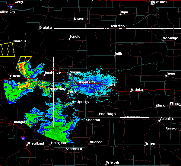 At 640 pm mdt, a severe thunderstorm was located 12 miles southwest of upton, or 34 miles west of newcastle, moving east at 45 mph (radar indicated). Hazards include quarter size hail. Damage to vehicles is expected. Locations impacted include, upton. At 640 pm mdt, a severe thunderstorm was located 12 miles southwest of upton, or 34 miles west of newcastle, moving east at 45 mph (radar indicated). Hazards include quarter size hail. Damage to vehicles is expected. Locations impacted include, upton.
|
| 6/15/2018 6:00 PM MDT |
 At 600 pm mdt, a severe thunderstorm was located 19 miles northeast of reno junction, or 21 miles northeast of wright, moving east at 30 mph (radar indicated). Hazards include 60 mph wind gusts and quarter size hail. Hail damage to vehicles is expected. Expect wind damage to roofs, siding, and trees. At 600 pm mdt, a severe thunderstorm was located 19 miles northeast of reno junction, or 21 miles northeast of wright, moving east at 30 mph (radar indicated). Hazards include 60 mph wind gusts and quarter size hail. Hail damage to vehicles is expected. Expect wind damage to roofs, siding, and trees.
|
| 5/31/2018 6:00 PM MDT | Quarter sized hail reported 11.7 miles E of Upton, WY |
| 5/7/2018 7:40 PM MDT |
 The severe thunderstorm warning for northeastern weston and southeastern crook counties will expire at 745 pm mdt, the storm which prompted the warning has weakened below severe limits and no longer poses an immediate threat to life or property. therefore, the warning will be allowed to expire. however, small hail and gusty winds are still possible with this thunderstorm. The severe thunderstorm warning for northeastern weston and southeastern crook counties will expire at 745 pm mdt, the storm which prompted the warning has weakened below severe limits and no longer poses an immediate threat to life or property. therefore, the warning will be allowed to expire. however, small hail and gusty winds are still possible with this thunderstorm.
|
| 5/7/2018 7:21 PM MDT |
 At 721 pm mdt, a severe thunderstorm was located near inyan kara mountain, or 13 miles south of sundance, moving east at 25 mph (radar indicated). Hazards include 60 mph wind gusts and quarter size hail. Hail damage to vehicles is expected. expect wind damage to roofs, siding, and trees. Locations impacted include, upton and inyan kara mountain. At 721 pm mdt, a severe thunderstorm was located near inyan kara mountain, or 13 miles south of sundance, moving east at 25 mph (radar indicated). Hazards include 60 mph wind gusts and quarter size hail. Hail damage to vehicles is expected. expect wind damage to roofs, siding, and trees. Locations impacted include, upton and inyan kara mountain.
|
| 5/7/2018 6:59 PM MDT |
 At 658 pm mdt, a severe thunderstorm was located 10 miles north of upton, or 16 miles southwest of sundance, moving southeast at 35 mph (radar indicated). Hazards include 60 mph wind gusts and quarter size hail. Hail damage to vehicles is expected. Expect wind damage to roofs, siding, and trees. At 658 pm mdt, a severe thunderstorm was located 10 miles north of upton, or 16 miles southwest of sundance, moving southeast at 35 mph (radar indicated). Hazards include 60 mph wind gusts and quarter size hail. Hail damage to vehicles is expected. Expect wind damage to roofs, siding, and trees.
|
| 7/20/2017 9:21 PM MDT |
 At 921 pm mdt, severe thunderstorms were located along a line extending from near inyan kara mountain to near osage to 8 miles south of clareton, moving east at 40 mph (radar indicated). Hazards include 60 mph wind gusts. Expect damage to roofs, siding, and trees. Locations impacted include, upton, osage, clareton, moskee and inyan kara mountain. At 921 pm mdt, severe thunderstorms were located along a line extending from near inyan kara mountain to near osage to 8 miles south of clareton, moving east at 40 mph (radar indicated). Hazards include 60 mph wind gusts. Expect damage to roofs, siding, and trees. Locations impacted include, upton, osage, clareton, moskee and inyan kara mountain.
|
| 7/20/2017 9:00 PM MDT |
 At 900 pm mdt, severe thunderstorms were located along a line extending from 8 miles north of upton to 14 miles west of osage to rochelle, moving east at 35 mph (radar indicated). Hazards include 60 mph wind gusts and nickel size hail. Expect damage to roofs, siding, and trees. Locations impacted include, upton, osage, clareton, moskee, rochelle and inyan kara mountain. At 900 pm mdt, severe thunderstorms were located along a line extending from 8 miles north of upton to 14 miles west of osage to rochelle, moving east at 35 mph (radar indicated). Hazards include 60 mph wind gusts and nickel size hail. Expect damage to roofs, siding, and trees. Locations impacted include, upton, osage, clareton, moskee, rochelle and inyan kara mountain.
|
| 7/20/2017 8:39 PM MDT |
 At 839 pm mdt, severe thunderstorms were located along a line extending from 8 miles southeast of moorcroft to 19 miles northwest of clareton to 15 miles west of dull center, moving east at 40 mph (radar indicated). Hazards include 60 mph wind gusts and quarter size hail. Hail damage to vehicles is expected. Expect wind damage to roofs, siding, and trees. At 839 pm mdt, severe thunderstorms were located along a line extending from 8 miles southeast of moorcroft to 19 miles northwest of clareton to 15 miles west of dull center, moving east at 40 mph (radar indicated). Hazards include 60 mph wind gusts and quarter size hail. Hail damage to vehicles is expected. Expect wind damage to roofs, siding, and trees.
|
| 7/20/2017 8:10 PM MDT |
 At 810 pm mdt, a severe thunderstorm was located 7 miles southeast of pine haven, or 19 miles southwest of sundance, moving east at 25 mph (radar indicated). Hazards include 60 mph wind gusts. Expect damage to roofs, siding, and trees. Locations impacted include, upton, pine haven and keyhole reservoir. At 810 pm mdt, a severe thunderstorm was located 7 miles southeast of pine haven, or 19 miles southwest of sundance, moving east at 25 mph (radar indicated). Hazards include 60 mph wind gusts. Expect damage to roofs, siding, and trees. Locations impacted include, upton, pine haven and keyhole reservoir.
|
| 7/20/2017 7:51 PM MDT |
 At 751 pm mdt, a severe thunderstorm was located near moorcroft, or 26 miles west of sundance, moving east at 25 mph (radar indicated). Hazards include 60 mph wind gusts. expect damage to roofs, siding, and trees At 751 pm mdt, a severe thunderstorm was located near moorcroft, or 26 miles west of sundance, moving east at 25 mph (radar indicated). Hazards include 60 mph wind gusts. expect damage to roofs, siding, and trees
|
| 6/27/2017 12:23 PM MDT |
 At 623 pm mdt, severe thunderstorms were located along a line extending from near devils tower national monument to near inyan kara mountain, moving east at 40 mph (radar indicated). Hazards include 60 mph wind gusts. Expect damage to roofs, siding, and trees. Locations impacted include, sundance, upton, hulett, beulah, alva, aladdin, moskee, four corners, buckhorn, cement ridge lookout, devils tower national monument, warren peak, inyan kara mountain, bear lodge campground, mallo camp, cook lake and devils tower junction. At 623 pm mdt, severe thunderstorms were located along a line extending from near devils tower national monument to near inyan kara mountain, moving east at 40 mph (radar indicated). Hazards include 60 mph wind gusts. Expect damage to roofs, siding, and trees. Locations impacted include, sundance, upton, hulett, beulah, alva, aladdin, moskee, four corners, buckhorn, cement ridge lookout, devils tower national monument, warren peak, inyan kara mountain, bear lodge campground, mallo camp, cook lake and devils tower junction.
|
| 6/27/2017 11:52 AM MDT |
 At 551 pm mdt, severe thunderstorms were located along a line extending from near oshoto to 7 miles southeast of moorcroft, moving east at 50 mph (radar indicated). Hazards include 60 mph wind gusts. expect damage to roofs, siding, and trees At 551 pm mdt, severe thunderstorms were located along a line extending from near oshoto to 7 miles southeast of moorcroft, moving east at 50 mph (radar indicated). Hazards include 60 mph wind gusts. expect damage to roofs, siding, and trees
|
| 8/8/2016 4:55 PM MDT |
 At 455 pm mdt, a severe thunderstorm was located 8 miles northeast of clareton, or 18 miles west of newcastle, moving northeast at 25 mph (radar indicated). Hazards include tennis ball size hail. People and animals outdoors will be injured. Expect damage to roofs, siding, windows, and vehicles. At 455 pm mdt, a severe thunderstorm was located 8 miles northeast of clareton, or 18 miles west of newcastle, moving northeast at 25 mph (radar indicated). Hazards include tennis ball size hail. People and animals outdoors will be injured. Expect damage to roofs, siding, windows, and vehicles.
|
| 8/7/2016 8:33 PM MDT |
 At 833 pm mdt, a severe thunderstorm was located 7 miles east of upton, or 19 miles south of sundance, moving east at 40 mph (radar indicated). Hazards include 60 mph wind gusts and quarter size hail. Hail damage to vehicles is expected. expect wind damage to roofs, siding, and trees. Locations impacted include, upton, buckhorn, four corners, moskee, cement ridge lookout, mallo camp and inyan kara mountain. At 833 pm mdt, a severe thunderstorm was located 7 miles east of upton, or 19 miles south of sundance, moving east at 40 mph (radar indicated). Hazards include 60 mph wind gusts and quarter size hail. Hail damage to vehicles is expected. expect wind damage to roofs, siding, and trees. Locations impacted include, upton, buckhorn, four corners, moskee, cement ridge lookout, mallo camp and inyan kara mountain.
|
| 8/7/2016 8:21 PM MDT |
 At 821 pm mdt, a severe thunderstorm was located over upton, or 25 miles southwest of sundance, moving east at 40 mph (radar indicated). Hazards include 60 mph wind gusts and quarter size hail. Hail damage to vehicles is expected. Expect wind damage to roofs, siding, and trees. At 821 pm mdt, a severe thunderstorm was located over upton, or 25 miles southwest of sundance, moving east at 40 mph (radar indicated). Hazards include 60 mph wind gusts and quarter size hail. Hail damage to vehicles is expected. Expect wind damage to roofs, siding, and trees.
|
| 6/28/2016 2:53 PM MDT | Quarter sized hail reported 7.7 miles N of Upton, WY |
| 6/28/2016 2:40 PM MDT | Quarter sized hail reported 19.3 miles NE of Upton, WY, 50 mph wnd gusts |
| 6/28/2016 2:05 PM MDT |
 At 204 pm mdt, a severe thunderstorm was located 15 miles south of rozet, or 23 miles southeast of gillette, moving southeast at 30 mph (radar indicated). Hazards include golf ball size hail and 60 mph wind gusts. People and animals outdoors will be injured. expect hail damage to roofs, siding, windows, and vehicles. Expect wind damage to roofs, siding, and trees. At 204 pm mdt, a severe thunderstorm was located 15 miles south of rozet, or 23 miles southeast of gillette, moving southeast at 30 mph (radar indicated). Hazards include golf ball size hail and 60 mph wind gusts. People and animals outdoors will be injured. expect hail damage to roofs, siding, windows, and vehicles. Expect wind damage to roofs, siding, and trees.
|
| 8/17/2015 8:03 PM MDT |
 At 802 pm mdt, severe thunderstorms were located along a line extending from near pine haven to 16 miles north of rochelle, moving east at 35 mph (radar indicated). Hazards include 60 mph wind gusts and nickel size hail. a 60 mph wind gust was reported 14 ssw of rozet around 734 pm mdt. Expect damage to roofs. siding and trees. locations impacted include, upton, moorcroft, osage and inyan kara mountain. This includes interstate 90 in wyoming between mile markers 155 and 172, and between mile markers 177 and 179. At 802 pm mdt, severe thunderstorms were located along a line extending from near pine haven to 16 miles north of rochelle, moving east at 35 mph (radar indicated). Hazards include 60 mph wind gusts and nickel size hail. a 60 mph wind gust was reported 14 ssw of rozet around 734 pm mdt. Expect damage to roofs. siding and trees. locations impacted include, upton, moorcroft, osage and inyan kara mountain. This includes interstate 90 in wyoming between mile markers 155 and 172, and between mile markers 177 and 179.
|
| 8/17/2015 7:30 PM MDT |
 At 729 pm mdt, severe thunderstorms were located along a line extending from near rozet to 7 miles northeast of reno junction, moving east at 35 mph (radar indicated). Hazards include 60 mph wind gusts and nickel size hail. Expect damage to roofs. Siding and trees. At 729 pm mdt, severe thunderstorms were located along a line extending from near rozet to 7 miles northeast of reno junction, moving east at 35 mph (radar indicated). Hazards include 60 mph wind gusts and nickel size hail. Expect damage to roofs. Siding and trees.
|
| 6/24/2015 9:58 AM MDT |
 At 957 am mdt, a severe thunderstorm was located 10 miles west of upton, or 33 miles southwest of sundance, moving southeast at 20 mph. a trained weather spotter reported quarter size hail at 948 am mdt 12 miles west of upton (trained weather spotters). Hazards include 60 mph wind gusts and quarter size hail. Hail damage to vehicles is expected. expect wind damage to roofs, siding and trees. Locations impacted include, upton. At 957 am mdt, a severe thunderstorm was located 10 miles west of upton, or 33 miles southwest of sundance, moving southeast at 20 mph. a trained weather spotter reported quarter size hail at 948 am mdt 12 miles west of upton (trained weather spotters). Hazards include 60 mph wind gusts and quarter size hail. Hail damage to vehicles is expected. expect wind damage to roofs, siding and trees. Locations impacted include, upton.
|
| 6/24/2015 9:48 AM MDT | Quarter sized hail reported 11.7 miles E of Upton, WY |
| 6/24/2015 9:46 AM MDT |
 At 946 am mdt, a severe thunderstorm was located 12 miles south of moorcroft, or 31 miles southeast of gillette, moving southeast at 20 mph. this is a very dangerous storm (radar indicated). Hazards include baseball size hail and 60 mph wind gusts. People and animals outdoors will be severely injured. Expect shattered windows, extensive damage to roofs, siding and vehicles. At 946 am mdt, a severe thunderstorm was located 12 miles south of moorcroft, or 31 miles southeast of gillette, moving southeast at 20 mph. this is a very dangerous storm (radar indicated). Hazards include baseball size hail and 60 mph wind gusts. People and animals outdoors will be severely injured. Expect shattered windows, extensive damage to roofs, siding and vehicles.
|
| 6/24/2015 1:26 AM MDT |
 At 125 am mdt, severe thunderstorms were located along a line extending from near inyan kara mountain to near upton to 12 miles northwest of clareton, moving east at 30 mph (radar indicated). Hazards include ping pong ball size hail and 60 mph wind gusts. People and animals outdoors will be injured. expect hail damage to roofs, siding, windows and vehicles. expect wind damage to roofs, siding and trees. Locations impacted include, upton, osage, moskee and inyan kara mountain. At 125 am mdt, severe thunderstorms were located along a line extending from near inyan kara mountain to near upton to 12 miles northwest of clareton, moving east at 30 mph (radar indicated). Hazards include ping pong ball size hail and 60 mph wind gusts. People and animals outdoors will be injured. expect hail damage to roofs, siding, windows and vehicles. expect wind damage to roofs, siding and trees. Locations impacted include, upton, osage, moskee and inyan kara mountain.
|
| 6/24/2015 12:58 AM MDT |
 At 1257 am mdt, severe thunderstorms were located along a line extending from 9 miles west of inyan kara mountain to 9 miles south of moorcroft to 20 miles north of rochelle, moving southeast at 35 mph (radar indicated). Hazards include ping pong ball size hail and 60 mph wind gusts. People and animals outdoors will be injured. expect hail damage to roofs, siding, windows and vehicles. Expect wind damage to roofs, siding and trees. At 1257 am mdt, severe thunderstorms were located along a line extending from 9 miles west of inyan kara mountain to 9 miles south of moorcroft to 20 miles north of rochelle, moving southeast at 35 mph (radar indicated). Hazards include ping pong ball size hail and 60 mph wind gusts. People and animals outdoors will be injured. expect hail damage to roofs, siding, windows and vehicles. Expect wind damage to roofs, siding and trees.
|
| 6/20/2015 11:24 PM MDT |
 At 1123 pm mdt, a severe thunderstorm was located over upton, or 24 miles northwest of newcastle, moving east at 40 mph (radar indicated). Hazards include half dollar size hail. damage to vehicles is expected At 1123 pm mdt, a severe thunderstorm was located over upton, or 24 miles northwest of newcastle, moving east at 40 mph (radar indicated). Hazards include half dollar size hail. damage to vehicles is expected
|
| 6/17/2015 10:12 PM MDT |
 At 1012 pm mdt, a severe thunderstorm was located near osage, or 9 miles northwest of newcastle, moving southeast at 45 mph (radar indicated). Hazards include 60 mph wind gusts and half dollar size hail. Hail damage to vehicles is expected. expect wind damage to roofs, siding and trees. Locations impacted include, newcastle, upton, osage and clareton. At 1012 pm mdt, a severe thunderstorm was located near osage, or 9 miles northwest of newcastle, moving southeast at 45 mph (radar indicated). Hazards include 60 mph wind gusts and half dollar size hail. Hail damage to vehicles is expected. expect wind damage to roofs, siding and trees. Locations impacted include, newcastle, upton, osage and clareton.
|
| 6/17/2015 9:49 PM MDT |
 At 948 pm mdt, a severe thunderstorm was located 7 miles southwest of upton, or 29 miles northwest of newcastle, moving southeast at 40 mph (radar indicated). Hazards include 60 mph wind gusts and quarter size hail. Hail damage to vehicles is expected. Expect wind damage to roofs, siding and trees. At 948 pm mdt, a severe thunderstorm was located 7 miles southwest of upton, or 29 miles northwest of newcastle, moving southeast at 40 mph (radar indicated). Hazards include 60 mph wind gusts and quarter size hail. Hail damage to vehicles is expected. Expect wind damage to roofs, siding and trees.
|
| 6/17/2015 9:06 PM MDT |
 At 906 pm mdt, a severe thunderstorm was located over southwestern keyhole reservoir, or 26 miles west of sundance, moving southeast at 35 mph (radar indicated). Hazards include 60 mph wind gusts and quarter size hail. Hail damage to vehicles is expected. Expect wind damage to roofs, siding and trees. At 906 pm mdt, a severe thunderstorm was located over southwestern keyhole reservoir, or 26 miles west of sundance, moving southeast at 35 mph (radar indicated). Hazards include 60 mph wind gusts and quarter size hail. Hail damage to vehicles is expected. Expect wind damage to roofs, siding and trees.
|
| 6/14/2015 12:53 AM MDT |
 At 1253 am mdt, a severe thunderstorm was located near upton, or 22 miles northwest of newcastle, moving northeast at 40 mph (radar indicated). Hazards include half dollar size hail. damage to vehicles is expected At 1253 am mdt, a severe thunderstorm was located near upton, or 22 miles northwest of newcastle, moving northeast at 40 mph (radar indicated). Hazards include half dollar size hail. damage to vehicles is expected
|
| 7/22/2014 6:25 PM MDT | Quarter sized hail reported 10.4 miles WNW of Upton, WY |
| 7/22/2014 6:20 PM MDT | Baseball sized hail reported 10.3 miles W of Upton, WY |
| 6/3/2014 3:50 PM MDT | Quarter sized hail reported 0.3 miles ENE of Upton, WY |
| 8/14/2013 6:25 PM MDT | Quarter sized hail reported 10.6 miles NNE of Upton, WY |
| 8/11/2013 6:31 PM MDT | Quarter sized hail reported 6.3 miles E of Upton, WY |
| 8/11/2013 6:23 PM MDT | Quarter sized hail reported 3 miles SE of Upton, WY |
| 8/5/2013 5:05 PM MDT | Quarter sized hail reported 3.1 miles NE of Upton, WY |
| 8/5/2013 4:16 PM MDT | Quarter sized hail reported 5.2 miles ENE of Upton, WY |
| 7/19/2013 8:45 PM MDT | Quarter sized hail reported 11.9 miles NNW of Upton, WY |
| 7/19/2013 8:27 PM MDT | Golf Ball sized hail reported 0.3 miles ENE of Upton, WY |
| 7/19/2013 8:18 PM MDT | Ping Pong Ball sized hail reported 0.3 miles ENE of Upton, WY |
| 7/19/2013 8:18 PM MDT | Golf Ball sized hail reported 0.3 miles ENE of Upton, WY |
| 7/7/2013 10:00 PM MDT | Time estimated in weston county WY, 0.3 miles ENE of Upton, WY |
| 5/27/2013 4:18 PM MDT | Hen Egg sized hail reported 3.7 miles W of Upton, WY, max hail size 2 inches. mostly golfball size. |
| 5/27/2013 3:55 PM MDT | Half Dollar sized hail reported 0.3 miles ENE of Upton, WY |
| 5/18/2013 6:18 PM MDT | Quarter sized hail reported 8.4 miles WNW of Upton, WY |
| 5/18/2013 5:25 PM MDT | Quarter sized hail reported 9.9 miles ENE of Upton, WY |
| 6/22/2012 9:55 PM MDT | Ping Pong Ball sized hail reported 0.3 miles ENE of Upton, WY |
| 1/1/0001 12:00 AM | Storm damage reported in crook county WY, 10.4 miles S of Upton, WY |
| 1/1/0001 12:00 AM | Storm damage reported in weston county WY, 0.3 miles ENE of Upton, WY |
| 1/1/0001 12:00 AM | Also had quarter size hai in crook county WY, 10.3 miles SSW of Upton, WY |
| 1/1/0001 12:00 AM | Quarter sized hail reported 19.3 miles NE of Upton, WY, could hear hail roar to the south. |
| 1/1/0001 12:00 AM | Golf Ball sized hail reported 0.2 miles WNW of Upton, WY |
| 1/1/0001 12:00 AM | Golf Ball sized hail reported 0.3 miles ENE of Upton, WY, large hail damaged homes and vehicles. |
Hail Maps for Upton, WY
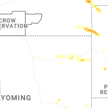
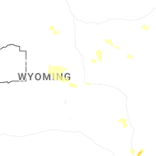


Connect with Interactive Hail Maps