

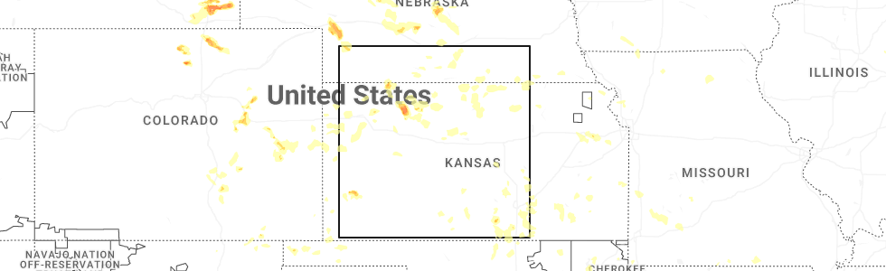
Hail Map for Utica, KS
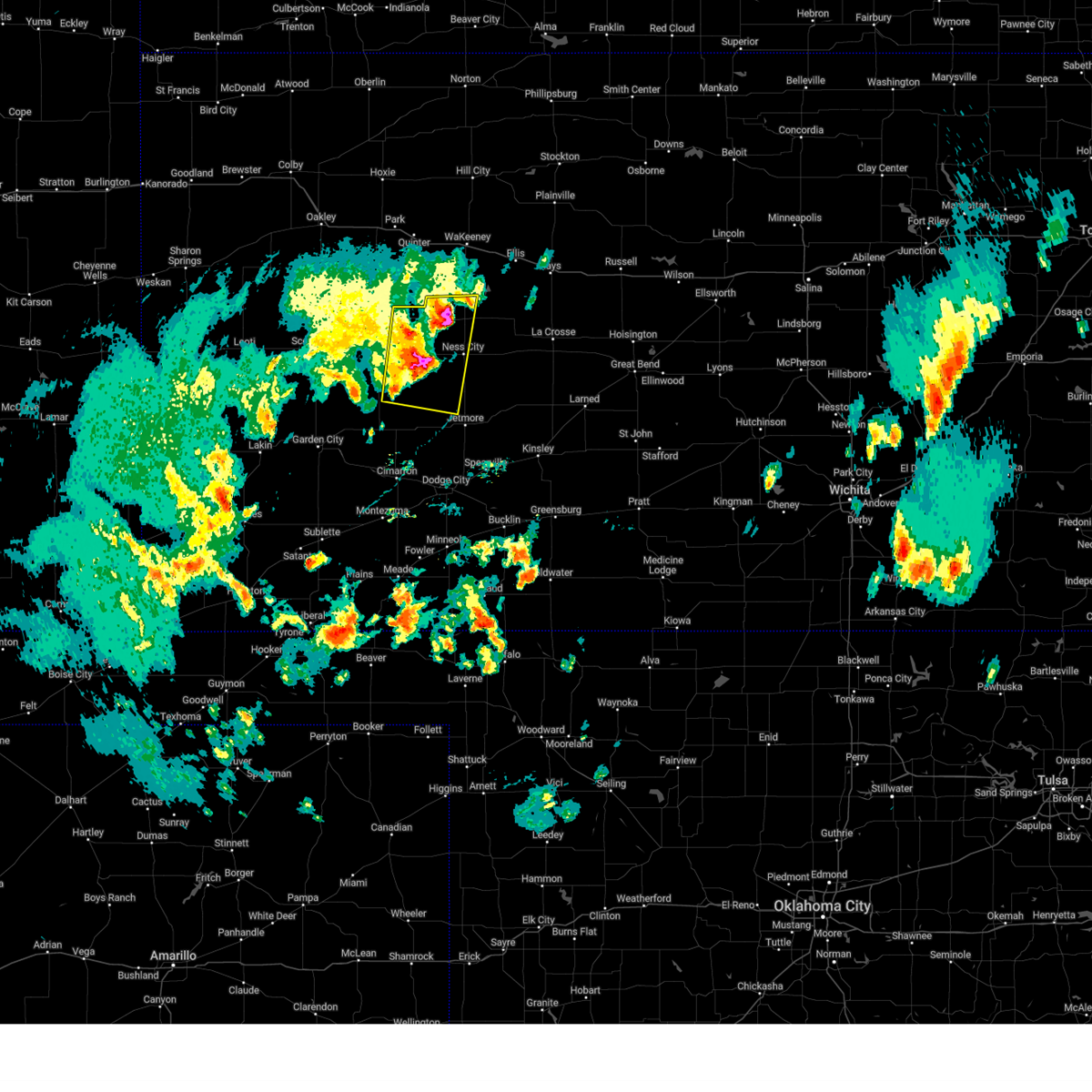
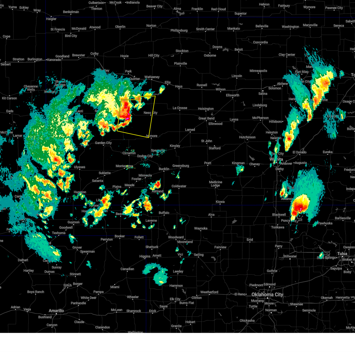
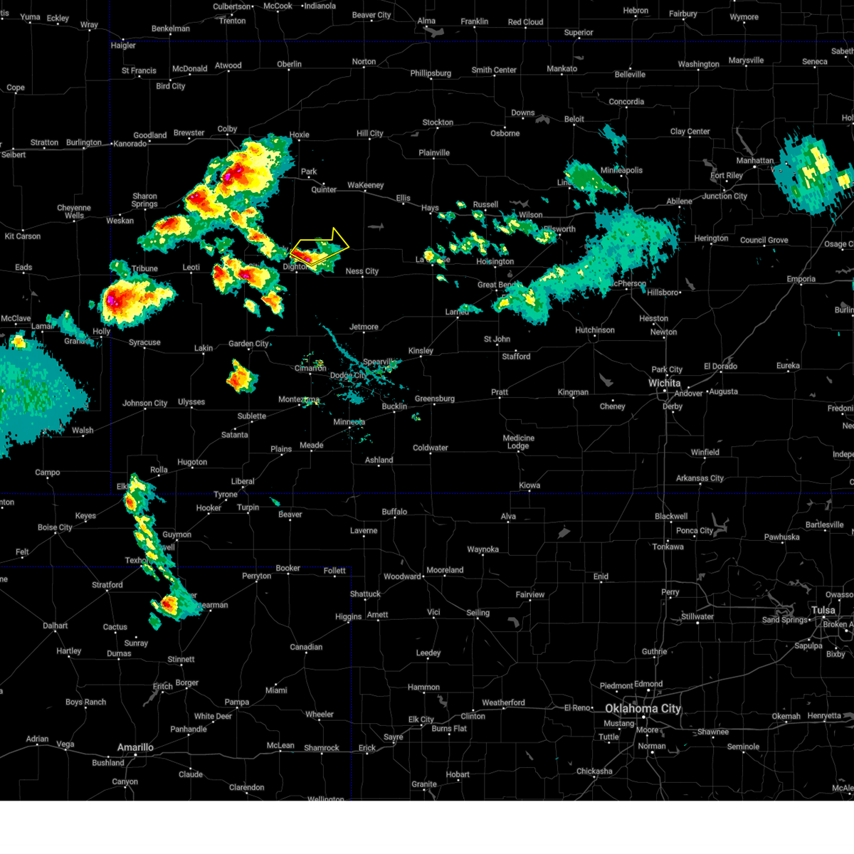
The Utica, KS area has had 17 reports of on-the-ground hail by trained spotters, and has been under severe weather warnings 10 times during the past 12 months. Doppler radar has detected hail at or near Utica, KS on 101 occasions, including 9 occasions during the past year.
| Name: | Utica, KS |
| Where Located: | 47.9 miles WSW of Hays, KS |
| Map: | Google Map for Utica, KS |
| Population: | 158 |
| Housing Units: | 102 |
| More Info: | Search Google for Utica, KS |
1
The Top Recent Hail Date for Utica, KS is Sunday, June 29, 2025 (32nd out of 101)
Hail and Wind Damage Spotted near Utica, KS
| Date / Time | Report Details |
|---|---|
| 5/19/2025 7:27 PM CDT |
 At 727 pm cdt, severe thunderstorms were located along a line extending from near pendennis to 9 miles southwest of beeler, moving east at 15 mph (radar indicated). Hazards include 60 mph wind gusts and quarter size hail. Hail damage to vehicles is expected. expect wind damage to roofs, siding, and trees. Locations impacted include, beeler and utica. At 727 pm cdt, severe thunderstorms were located along a line extending from near pendennis to 9 miles southwest of beeler, moving east at 15 mph (radar indicated). Hazards include 60 mph wind gusts and quarter size hail. Hail damage to vehicles is expected. expect wind damage to roofs, siding, and trees. Locations impacted include, beeler and utica.
|
| 5/19/2025 7:00 PM CDT |
 Svrddc the national weather service in dodge city has issued a * severe thunderstorm warning for, northeastern finney county in southwestern kansas, western ness county in west central kansas, northwestern hodgeman county in southwestern kansas, southwestern trego county in west central kansas, lane county in west central kansas, * until 745 pm cdt. * at 700 pm cdt, severe thunderstorms were located along a line extending from near shields to 9 miles southwest of alamota, moving east at 15 mph (radar indicated). Hazards include 60 mph wind gusts and quarter size hail. Hail damage to vehicles is expected. expect wind damage to roofs, siding, and trees. Severe thunderstorms will be near, alamota and pendennis around 705 pm cdt. Svrddc the national weather service in dodge city has issued a * severe thunderstorm warning for, northeastern finney county in southwestern kansas, western ness county in west central kansas, northwestern hodgeman county in southwestern kansas, southwestern trego county in west central kansas, lane county in west central kansas, * until 745 pm cdt. * at 700 pm cdt, severe thunderstorms were located along a line extending from near shields to 9 miles southwest of alamota, moving east at 15 mph (radar indicated). Hazards include 60 mph wind gusts and quarter size hail. Hail damage to vehicles is expected. expect wind damage to roofs, siding, and trees. Severe thunderstorms will be near, alamota and pendennis around 705 pm cdt.
|
| 5/18/2025 6:42 PM CDT | Svrddc the national weather service in dodge city has issued a * severe thunderstorm warning for, northwestern ness county in west central kansas, southern trego county in west central kansas, northeastern lane county in west central kansas, west central ellis county in central kansas, * until 730 pm cdt. * at 641 pm cdt, a severe thunderstorm was located near utica, moving northeast at 45 mph (radar indicated). Hazards include two inch hail. People and animals outdoors will be injured. expect damage to roofs, siding, windows, and vehicles. this severe thunderstorm will be near, utica around 645 pm cdt. Other locations in the path of this severe thunderstorm include trego center. |
| 4/23/2025 5:03 PM CDT |
 At 502 pm cdt, a severe thunderstorm was located near pendennis, moving northeast at 20 mph (radar indicated). Hazards include tennis ball size hail. People and animals outdoors will be injured. expect damage to roofs, siding, windows, and vehicles. This severe storm will be near, pendennis around 510 pm cdt. At 502 pm cdt, a severe thunderstorm was located near pendennis, moving northeast at 20 mph (radar indicated). Hazards include tennis ball size hail. People and animals outdoors will be injured. expect damage to roofs, siding, windows, and vehicles. This severe storm will be near, pendennis around 510 pm cdt.
|
| 4/23/2025 4:55 PM CDT |
 At 455 pm cdt, a severe thunderstorm was located near shields, moving northeast at 20 mph (radar indicated). Hazards include two inch hail. People and animals outdoors will be injured. expect damage to roofs, siding, windows, and vehicles. This severe storm will be near, pendennis around 500 pm cdt. At 455 pm cdt, a severe thunderstorm was located near shields, moving northeast at 20 mph (radar indicated). Hazards include two inch hail. People and animals outdoors will be injured. expect damage to roofs, siding, windows, and vehicles. This severe storm will be near, pendennis around 500 pm cdt.
|
| 4/23/2025 4:48 PM CDT |
 Svrddc the national weather service in dodge city has issued a * severe thunderstorm warning for, northwestern ness county in west central kansas, southwestern trego county in west central kansas, northeastern lane county in west central kansas, * until 530 pm cdt. * at 447 pm cdt, a severe thunderstorm was located near shields, moving northeast at 25 mph (radar indicated). Hazards include quarter size hail. Damage to vehicles is expected. this severe thunderstorm will be near, shields around 455 pm cdt. Pendennis around 505 pm cdt. Svrddc the national weather service in dodge city has issued a * severe thunderstorm warning for, northwestern ness county in west central kansas, southwestern trego county in west central kansas, northeastern lane county in west central kansas, * until 530 pm cdt. * at 447 pm cdt, a severe thunderstorm was located near shields, moving northeast at 25 mph (radar indicated). Hazards include quarter size hail. Damage to vehicles is expected. this severe thunderstorm will be near, shields around 455 pm cdt. Pendennis around 505 pm cdt.
|
| 8/29/2024 4:39 PM CDT | At 438 pm cdt, a severe thunderstorm was located near utica, moving northeast at 20 mph (radar indicated). Hazards include 60 mph wind gusts and penny size hail. Expect damage to roofs, siding, and trees. This severe thunderstorm will remain over mainly rural areas of northern ness, southwestern trego and northeastern lane counties. |
| 8/29/2024 4:17 PM CDT | Svrddc the national weather service in dodge city has issued a * severe thunderstorm warning for, northern ness county in west central kansas, southwestern trego county in west central kansas, northeastern lane county in west central kansas, * until 500 pm cdt. * at 416 pm cdt, a severe thunderstorm was located near pendennis, moving northeast at 20 mph (radar indicated). Hazards include 60 mph wind gusts and penny size hail. Expect damage to roofs, siding, and trees. This severe thunderstorm will be near, utica around 420 pm cdt. |
| 7/6/2024 5:34 PM CDT |
 Svrddc the national weather service in dodge city has issued a * severe thunderstorm warning for, eastern scott county in west central kansas, ness county in west central kansas, southern trego county in west central kansas, lane county in west central kansas, * until 630 pm cdt. * at 533 pm cdt, severe thunderstorms were located along a line extending from near scott state lake to 6 miles north of beeler, moving southeast at 40 mph. these are destructive storms (radar indicated). Hazards include 80 mph wind gusts and golf ball size hail. Flying debris will be dangerous to those caught without shelter. mobile homes will be heavily damaged. expect considerable damage to roofs, windows, and vehicles. extensive tree damage and power outages are likely. severe thunderstorms will be near, dighton, alamota, manning, and beeler around 540 pm cdt. Grigston and amy around 545 pm cdt. Svrddc the national weather service in dodge city has issued a * severe thunderstorm warning for, eastern scott county in west central kansas, ness county in west central kansas, southern trego county in west central kansas, lane county in west central kansas, * until 630 pm cdt. * at 533 pm cdt, severe thunderstorms were located along a line extending from near scott state lake to 6 miles north of beeler, moving southeast at 40 mph. these are destructive storms (radar indicated). Hazards include 80 mph wind gusts and golf ball size hail. Flying debris will be dangerous to those caught without shelter. mobile homes will be heavily damaged. expect considerable damage to roofs, windows, and vehicles. extensive tree damage and power outages are likely. severe thunderstorms will be near, dighton, alamota, manning, and beeler around 540 pm cdt. Grigston and amy around 545 pm cdt.
|
| 7/6/2024 5:09 PM CDT | Storm damage reported in gove county KS, 13 miles SE of Utica, KS |
| 7/6/2024 5:04 PM CDT | Weather underground site kksutica3 reported a 60 mph wind gus in gove county KS, 13 miles SE of Utica, KS |
| 7/6/2024 4:59 PM CDT |
 Svrddc the national weather service in dodge city has issued a * severe thunderstorm warning for, northwestern ness county in west central kansas, southwestern trego county in west central kansas, * until 545 pm cdt. * at 456 pm cdt, a severe thunderstorm was located 11 miles north of pendennis, moving southeast at 35 mph. this is a destructive storm (radar indicated). Hazards include 80 mph wind gusts and ping pong ball size hail. Flying debris will be dangerous to those caught without shelter. mobile homes will be heavily damaged. expect considerable damage to roofs, windows, and vehicles. Extensive tree damage and power outages are likely. Svrddc the national weather service in dodge city has issued a * severe thunderstorm warning for, northwestern ness county in west central kansas, southwestern trego county in west central kansas, * until 545 pm cdt. * at 456 pm cdt, a severe thunderstorm was located 11 miles north of pendennis, moving southeast at 35 mph. this is a destructive storm (radar indicated). Hazards include 80 mph wind gusts and ping pong ball size hail. Flying debris will be dangerous to those caught without shelter. mobile homes will be heavily damaged. expect considerable damage to roofs, windows, and vehicles. Extensive tree damage and power outages are likely.
|
| 6/29/2024 1:34 AM CDT |
 the severe thunderstorm warning has been cancelled and is no longer in effect the severe thunderstorm warning has been cancelled and is no longer in effect
|
| 6/29/2024 1:27 AM CDT |
 At 127 am cdt, a severe thunderstorm was located 7 miles southeast of pendennis, moving east at 30 mph (radar indicated). Hazards include 60 mph wind gusts and quarter size hail. Hail damage to vehicles is expected. expect wind damage to roofs, siding, and trees. Locations impacted include, dighton, utica, alamota, beeler, pendennis, shields, and arnold. At 127 am cdt, a severe thunderstorm was located 7 miles southeast of pendennis, moving east at 30 mph (radar indicated). Hazards include 60 mph wind gusts and quarter size hail. Hail damage to vehicles is expected. expect wind damage to roofs, siding, and trees. Locations impacted include, dighton, utica, alamota, beeler, pendennis, shields, and arnold.
|
| 6/29/2024 1:20 AM CDT |
 At 120 am cdt, a severe thunderstorm was located near pendennis, moving east at 30 mph (radar indicated). Hazards include golf ball size hail and 60 mph wind gusts. People and animals outdoors will be injured. expect hail damage to roofs, siding, windows, and vehicles. expect wind damage to roofs, siding, and trees. This severe thunderstorm will remain over mainly rural areas of western ness and northeastern lane counties. At 120 am cdt, a severe thunderstorm was located near pendennis, moving east at 30 mph (radar indicated). Hazards include golf ball size hail and 60 mph wind gusts. People and animals outdoors will be injured. expect hail damage to roofs, siding, windows, and vehicles. expect wind damage to roofs, siding, and trees. This severe thunderstorm will remain over mainly rural areas of western ness and northeastern lane counties.
|
| 6/29/2024 1:10 AM CDT |
 Svrddc the national weather service in dodge city has issued a * severe thunderstorm warning for, western ness county in west central kansas, northern lane county in west central kansas, * until 200 am cdt. * at 110 am cdt, a severe thunderstorm was located near pendennis, moving east at 35 mph (radar indicated). Hazards include two inch hail and 70 mph wind gusts. People and animals outdoors will be injured. expect hail damage to roofs, siding, windows, and vehicles. expect considerable tree damage. wind damage is also likely to mobile homes, roofs, and outbuildings. This severe thunderstorm will be near, arnold around 130 am cdt. Svrddc the national weather service in dodge city has issued a * severe thunderstorm warning for, western ness county in west central kansas, northern lane county in west central kansas, * until 200 am cdt. * at 110 am cdt, a severe thunderstorm was located near pendennis, moving east at 35 mph (radar indicated). Hazards include two inch hail and 70 mph wind gusts. People and animals outdoors will be injured. expect hail damage to roofs, siding, windows, and vehicles. expect considerable tree damage. wind damage is also likely to mobile homes, roofs, and outbuildings. This severe thunderstorm will be near, arnold around 130 am cdt.
|
| 6/13/2024 5:54 PM CDT |
 The storms which prompted the warning have weakened below severe limits, and no longer pose an immediate threat to life or property. therefore, the warning will be allowed to expire. however, small hail, gusty winds and heavy rain are still possible with these thunderstorms. a severe thunderstorm watch remains in effect until 1100 pm cdt for central and west central kansas. The storms which prompted the warning have weakened below severe limits, and no longer pose an immediate threat to life or property. therefore, the warning will be allowed to expire. however, small hail, gusty winds and heavy rain are still possible with these thunderstorms. a severe thunderstorm watch remains in effect until 1100 pm cdt for central and west central kansas.
|
| 6/13/2024 5:22 PM CDT |
 At 522 pm cdt, severe thunderstorms were located along a line extending from near mccracken to near arnold, moving south at 15 mph (radar indicated). Hazards include golf ball size hail and 60 mph wind gusts. People and animals outdoors will be injured. expect hail damage to roofs, siding, windows, and vehicles. expect wind damage to roofs, siding, and trees. Locations impacted include, ness city, bazine, ransom, mccracken, rush center, utica, alexander, brownell, nekoma, hargrave, beeler, and arnold. At 522 pm cdt, severe thunderstorms were located along a line extending from near mccracken to near arnold, moving south at 15 mph (radar indicated). Hazards include golf ball size hail and 60 mph wind gusts. People and animals outdoors will be injured. expect hail damage to roofs, siding, windows, and vehicles. expect wind damage to roofs, siding, and trees. Locations impacted include, ness city, bazine, ransom, mccracken, rush center, utica, alexander, brownell, nekoma, hargrave, beeler, and arnold.
|
| 6/13/2024 5:12 PM CDT |
 At 512 pm cdt, severe thunderstorms were located along a line extending from near mccracken to near arnold, moving south at 15 mph (radar indicated). Hazards include 60 mph wind gusts and quarter size hail. Hail damage to vehicles is expected. expect wind damage to roofs, siding, and trees. Locations impacted include, ness city, bazine, ransom, mccracken, rush center, utica, alexander, brownell, nekoma, hargrave, beeler, and arnold. At 512 pm cdt, severe thunderstorms were located along a line extending from near mccracken to near arnold, moving south at 15 mph (radar indicated). Hazards include 60 mph wind gusts and quarter size hail. Hail damage to vehicles is expected. expect wind damage to roofs, siding, and trees. Locations impacted include, ness city, bazine, ransom, mccracken, rush center, utica, alexander, brownell, nekoma, hargrave, beeler, and arnold.
|
| 6/13/2024 4:57 PM CDT |
 Svrddc the national weather service in dodge city has issued a * severe thunderstorm warning for, ness county in west central kansas, western rush county in central kansas, * until 600 pm cdt. * at 457 pm cdt, severe thunderstorms were located along a line extending from near brownell to near utica, moving south at 15 mph (radar indicated). Hazards include 60 mph wind gusts and penny size hail. Expect damage to roofs, siding, and trees. severe thunderstorms will be near, mccracken around 505 pm cdt. Other locations in the path of these severe thunderstorms include ness city, bazine and alexander. Svrddc the national weather service in dodge city has issued a * severe thunderstorm warning for, ness county in west central kansas, western rush county in central kansas, * until 600 pm cdt. * at 457 pm cdt, severe thunderstorms were located along a line extending from near brownell to near utica, moving south at 15 mph (radar indicated). Hazards include 60 mph wind gusts and penny size hail. Expect damage to roofs, siding, and trees. severe thunderstorms will be near, mccracken around 505 pm cdt. Other locations in the path of these severe thunderstorms include ness city, bazine and alexander.
|
| 6/4/2024 11:03 AM CDT |
 At 1103 am cdt, a severe thunderstorm was located very near utica, moving east at 25 mph (public). Hazards include half dollar size hail. Damage to vehicles is expected. Locations impacted include, arnold and ransom. At 1103 am cdt, a severe thunderstorm was located very near utica, moving east at 25 mph (public). Hazards include half dollar size hail. Damage to vehicles is expected. Locations impacted include, arnold and ransom.
|
| 6/4/2024 11:03 AM CDT |
 the severe thunderstorm warning has been cancelled and is no longer in effect the severe thunderstorm warning has been cancelled and is no longer in effect
|
| 6/4/2024 10:48 AM CDT |
 Svrddc the national weather service in dodge city has issued a * severe thunderstorm warning for, northwestern ness county in west central kansas, southwestern trego county in west central kansas, northeastern lane county in west central kansas, * until 1145 am cdt. * at 1047 am cdt, a severe thunderstorm was located near pendennis, moving east at 20 mph (radar indicated). Hazards include 60 mph wind gusts and half dollar size hail. Hail damage to vehicles is expected. expect wind damage to roofs, siding, and trees. this severe thunderstorm will be near, utica around 1100 am cdt. Other locations in the path of this severe thunderstorm include arnold. Svrddc the national weather service in dodge city has issued a * severe thunderstorm warning for, northwestern ness county in west central kansas, southwestern trego county in west central kansas, northeastern lane county in west central kansas, * until 1145 am cdt. * at 1047 am cdt, a severe thunderstorm was located near pendennis, moving east at 20 mph (radar indicated). Hazards include 60 mph wind gusts and half dollar size hail. Hail damage to vehicles is expected. expect wind damage to roofs, siding, and trees. this severe thunderstorm will be near, utica around 1100 am cdt. Other locations in the path of this severe thunderstorm include arnold.
|
| 6/1/2024 7:54 PM CDT |
 Svrddc the national weather service in dodge city has issued a * severe thunderstorm warning for, northern ness county in west central kansas, southwestern trego county in west central kansas, * until 845 pm cdt. * at 753 pm cdt, a severe thunderstorm was located very near utica, moving east at 35 mph (radar indicated). Hazards include ping pong ball size hail and 60 mph wind gusts. People and animals outdoors will be injured. expect hail damage to roofs, siding, windows, and vehicles. expect wind damage to roofs, siding, and trees. this severe thunderstorm will be near, arnold around 800 pm cdt. ransom around 810 pm cdt. This new warning replaces the previous warning which was in effect for northwestern lane county. Svrddc the national weather service in dodge city has issued a * severe thunderstorm warning for, northern ness county in west central kansas, southwestern trego county in west central kansas, * until 845 pm cdt. * at 753 pm cdt, a severe thunderstorm was located very near utica, moving east at 35 mph (radar indicated). Hazards include ping pong ball size hail and 60 mph wind gusts. People and animals outdoors will be injured. expect hail damage to roofs, siding, windows, and vehicles. expect wind damage to roofs, siding, and trees. this severe thunderstorm will be near, arnold around 800 pm cdt. ransom around 810 pm cdt. This new warning replaces the previous warning which was in effect for northwestern lane county.
|
| 6/1/2024 7:40 PM CDT |
 At 739 pm cdt, a severe thunderstorm was located near pendennis, moving east at 35 mph (radar indicated). Hazards include golf ball size hail and 70 mph wind gusts. People and animals outdoors will be injured. expect hail damage to roofs, siding, windows, and vehicles. expect considerable tree damage. wind damage is also likely to mobile homes, roofs, and outbuildings. Locations impacted include, pendennis and utica. At 739 pm cdt, a severe thunderstorm was located near pendennis, moving east at 35 mph (radar indicated). Hazards include golf ball size hail and 70 mph wind gusts. People and animals outdoors will be injured. expect hail damage to roofs, siding, windows, and vehicles. expect considerable tree damage. wind damage is also likely to mobile homes, roofs, and outbuildings. Locations impacted include, pendennis and utica.
|
| 6/1/2024 7:21 PM CDT |
 Svrddc the national weather service in dodge city has issued a * severe thunderstorm warning for, northwestern ness county in west central kansas, lane county in west central kansas, * until 800 pm cdt. * at 720 pm cdt, a severe thunderstorm was located near healy, moving east at 35 mph (radar indicated). Hazards include ping pong ball size hail and 60 mph wind gusts. People and animals outdoors will be injured. expect hail damage to roofs, siding, windows, and vehicles. expect wind damage to roofs, siding, and trees. this severe thunderstorm will be near, shields around 725 pm cdt. pendennis around 740 pm cdt. other locations in the path of this severe thunderstorm include utica. This warning replaces the previous warning which was in effect for southwestern lane county. Svrddc the national weather service in dodge city has issued a * severe thunderstorm warning for, northwestern ness county in west central kansas, lane county in west central kansas, * until 800 pm cdt. * at 720 pm cdt, a severe thunderstorm was located near healy, moving east at 35 mph (radar indicated). Hazards include ping pong ball size hail and 60 mph wind gusts. People and animals outdoors will be injured. expect hail damage to roofs, siding, windows, and vehicles. expect wind damage to roofs, siding, and trees. this severe thunderstorm will be near, shields around 725 pm cdt. pendennis around 740 pm cdt. other locations in the path of this severe thunderstorm include utica. This warning replaces the previous warning which was in effect for southwestern lane county.
|
| 5/28/2024 1:29 PM CDT |
 Svrddc the national weather service in dodge city has issued a * severe thunderstorm warning for, northwestern ness county in west central kansas, northeastern lane county in west central kansas, * until 200 pm cdt. * at 129 pm cdt, a severe thunderstorm was located 7 miles northeast of pendennis, moving southeast at 30 mph (radar indicated). Hazards include quarter size hail. Damage to vehicles is expected. This severe thunderstorm will be near, utica around 140 pm cdt. Svrddc the national weather service in dodge city has issued a * severe thunderstorm warning for, northwestern ness county in west central kansas, northeastern lane county in west central kansas, * until 200 pm cdt. * at 129 pm cdt, a severe thunderstorm was located 7 miles northeast of pendennis, moving southeast at 30 mph (radar indicated). Hazards include quarter size hail. Damage to vehicles is expected. This severe thunderstorm will be near, utica around 140 pm cdt.
|
| 5/19/2024 5:52 PM CDT |
 Svrddc the national weather service in dodge city has issued a * severe thunderstorm warning for, ness county in west central kansas, hodgeman county in southwestern kansas, southern trego county in west central kansas, pawnee county in south central kansas, southeastern lane county in west central kansas, northern stafford county in south central kansas, rush county in central kansas, northwestern edwards county in south central kansas, southern ellis county in central kansas, * until 645 pm cdt. * at 552 pm cdt, severe thunderstorms were located along a line extending from 7 miles south of alamota to 8 miles southwest of bazine to 9 miles southeast of gray, moving east at 55 mph (radar indicated). Hazards include 70 mph wind gusts and penny size hail. Expect considerable tree damage. damage is likely to mobile homes, roofs, and outbuildings. severe thunderstorms will be near, burdett around 555 pm cdt. ness city, bazine, rozel, and beeler around 600 pm cdt. garfield, alexander, and sanford around 605 pm cdt. frizell and nekoma around 610 pm cdt. Other locations in the path of these severe thunderstorms include larned, rush center, ash valley, la crosse, bison, timken, radium, shaffer, hargrave, otis and mccracken. Svrddc the national weather service in dodge city has issued a * severe thunderstorm warning for, ness county in west central kansas, hodgeman county in southwestern kansas, southern trego county in west central kansas, pawnee county in south central kansas, southeastern lane county in west central kansas, northern stafford county in south central kansas, rush county in central kansas, northwestern edwards county in south central kansas, southern ellis county in central kansas, * until 645 pm cdt. * at 552 pm cdt, severe thunderstorms were located along a line extending from 7 miles south of alamota to 8 miles southwest of bazine to 9 miles southeast of gray, moving east at 55 mph (radar indicated). Hazards include 70 mph wind gusts and penny size hail. Expect considerable tree damage. damage is likely to mobile homes, roofs, and outbuildings. severe thunderstorms will be near, burdett around 555 pm cdt. ness city, bazine, rozel, and beeler around 600 pm cdt. garfield, alexander, and sanford around 605 pm cdt. frizell and nekoma around 610 pm cdt. Other locations in the path of these severe thunderstorms include larned, rush center, ash valley, la crosse, bison, timken, radium, shaffer, hargrave, otis and mccracken.
|
| 5/1/2024 9:21 PM CDT |
 Torddc the national weather service in dodge city has issued a * tornado warning for, northwestern ness county in west central kansas, southwestern trego county in west central kansas, * until 945 pm cdt. * at 921 pm cdt, a severe thunderstorm capable of producing a tornado was located very near utica, moving east at 10 mph (radar indicated rotation). Hazards include tornado and hail up to two inches in diameter. Flying debris will be dangerous to those caught without shelter. mobile homes will be damaged or destroyed. damage to roofs, windows, and vehicles will occur. tree damage is likely. This dangerous storm will be near, utica around 925 pm cdt. Torddc the national weather service in dodge city has issued a * tornado warning for, northwestern ness county in west central kansas, southwestern trego county in west central kansas, * until 945 pm cdt. * at 921 pm cdt, a severe thunderstorm capable of producing a tornado was located very near utica, moving east at 10 mph (radar indicated rotation). Hazards include tornado and hail up to two inches in diameter. Flying debris will be dangerous to those caught without shelter. mobile homes will be damaged or destroyed. damage to roofs, windows, and vehicles will occur. tree damage is likely. This dangerous storm will be near, utica around 925 pm cdt.
|
| 5/1/2024 9:19 PM CDT |
 At 919 pm cdt, a severe thunderstorm was located near utica, moving east at 15 mph (radar indicated). Hazards include two inch hail and 70 mph wind gusts. People and animals outdoors will be injured. expect hail damage to roofs, siding, windows, and vehicles. expect considerable tree damage. wind damage is also likely to mobile homes, roofs, and outbuildings. Locations impacted include, utica and arnold. At 919 pm cdt, a severe thunderstorm was located near utica, moving east at 15 mph (radar indicated). Hazards include two inch hail and 70 mph wind gusts. People and animals outdoors will be injured. expect hail damage to roofs, siding, windows, and vehicles. expect considerable tree damage. wind damage is also likely to mobile homes, roofs, and outbuildings. Locations impacted include, utica and arnold.
|
| 5/1/2024 9:13 PM CDT |
 At 913 pm cdt, a severe thunderstorm capable of producing a tornado was located near utica, moving east at 15 mph (radar indicated rotation). Hazards include tornado and two inch hail. Flying debris will be dangerous to those caught without shelter. mobile homes will be damaged or destroyed. damage to roofs, windows, and vehicles will occur. tree damage is likely. Locations impacted include, utica. At 913 pm cdt, a severe thunderstorm capable of producing a tornado was located near utica, moving east at 15 mph (radar indicated rotation). Hazards include tornado and two inch hail. Flying debris will be dangerous to those caught without shelter. mobile homes will be damaged or destroyed. damage to roofs, windows, and vehicles will occur. tree damage is likely. Locations impacted include, utica.
|
| 5/1/2024 9:00 PM CDT |
 At 900 pm cdt, a confirmed tornado was located near pendennis, moving east at 15 mph (weather spotters confirmed tornado). Hazards include damaging tornado and two inch hail. Flying debris will be dangerous to those caught without shelter. mobile homes will be damaged or destroyed. damage to roofs, windows, and vehicles will occur. tree damage is likely. Locations impacted include, utica and pendennis. At 900 pm cdt, a confirmed tornado was located near pendennis, moving east at 15 mph (weather spotters confirmed tornado). Hazards include damaging tornado and two inch hail. Flying debris will be dangerous to those caught without shelter. mobile homes will be damaged or destroyed. damage to roofs, windows, and vehicles will occur. tree damage is likely. Locations impacted include, utica and pendennis.
|
| 5/1/2024 8:58 PM CDT |
 Svrddc the national weather service in dodge city has issued a * severe thunderstorm warning for, northwestern ness county in west central kansas, southwestern trego county in west central kansas, northeastern lane county in west central kansas, * until 945 pm cdt. * at 858 pm cdt, a severe thunderstorm was located near pendennis, moving east at 15 mph (radar indicated). Hazards include two inch hail and 70 mph wind gusts. People and animals outdoors will be injured. expect hail damage to roofs, siding, windows, and vehicles. expect considerable tree damage. wind damage is also likely to mobile homes, roofs, and outbuildings. This severe thunderstorm will remain over mainly rural areas of northwestern ness, southwestern trego and northeastern lane counties. Svrddc the national weather service in dodge city has issued a * severe thunderstorm warning for, northwestern ness county in west central kansas, southwestern trego county in west central kansas, northeastern lane county in west central kansas, * until 945 pm cdt. * at 858 pm cdt, a severe thunderstorm was located near pendennis, moving east at 15 mph (radar indicated). Hazards include two inch hail and 70 mph wind gusts. People and animals outdoors will be injured. expect hail damage to roofs, siding, windows, and vehicles. expect considerable tree damage. wind damage is also likely to mobile homes, roofs, and outbuildings. This severe thunderstorm will remain over mainly rural areas of northwestern ness, southwestern trego and northeastern lane counties.
|
| 5/1/2024 8:54 PM CDT |
 Torddc the national weather service in dodge city has issued a * tornado warning for, northwestern ness county in west central kansas, northeastern lane county in west central kansas, * until 930 pm cdt. * at 854 pm cdt, a severe thunderstorm capable of producing a tornado was located near pendennis, moving east at 15 mph (radar indicated rotation). Hazards include tornado and hail up to two inches in diameter. Flying debris will be dangerous to those caught without shelter. mobile homes will be damaged or destroyed. damage to roofs, windows, and vehicles will occur. Tree damage is likely. Torddc the national weather service in dodge city has issued a * tornado warning for, northwestern ness county in west central kansas, northeastern lane county in west central kansas, * until 930 pm cdt. * at 854 pm cdt, a severe thunderstorm capable of producing a tornado was located near pendennis, moving east at 15 mph (radar indicated rotation). Hazards include tornado and hail up to two inches in diameter. Flying debris will be dangerous to those caught without shelter. mobile homes will be damaged or destroyed. damage to roofs, windows, and vehicles will occur. Tree damage is likely.
|
| 5/1/2024 8:50 PM CDT |
 At 849 pm cdt, a severe thunderstorm was located 12 miles north of utica, moving east at 25 mph (radar indicated). Hazards include two inch hail and 70 mph wind gusts. People and animals outdoors will be injured. expect hail damage to roofs, siding, windows, and vehicles. expect considerable tree damage. wind damage is also likely to mobile homes, roofs, and outbuildings. Locations impacted include, utica, pendennis, and arnold. At 849 pm cdt, a severe thunderstorm was located 12 miles north of utica, moving east at 25 mph (radar indicated). Hazards include two inch hail and 70 mph wind gusts. People and animals outdoors will be injured. expect hail damage to roofs, siding, windows, and vehicles. expect considerable tree damage. wind damage is also likely to mobile homes, roofs, and outbuildings. Locations impacted include, utica, pendennis, and arnold.
|
| 5/1/2024 8:25 PM CDT |
 At 825 pm cdt, a severe thunderstorm was located 9 miles north of pendennis, moving east at 25 mph (radar indicated). Hazards include two inch hail and 70 mph wind gusts. People and animals outdoors will be injured. expect hail damage to roofs, siding, windows, and vehicles. expect considerable tree damage. wind damage is also likely to mobile homes, roofs, and outbuildings. Locations impacted include, utica, pendennis, shields, and arnold. At 825 pm cdt, a severe thunderstorm was located 9 miles north of pendennis, moving east at 25 mph (radar indicated). Hazards include two inch hail and 70 mph wind gusts. People and animals outdoors will be injured. expect hail damage to roofs, siding, windows, and vehicles. expect considerable tree damage. wind damage is also likely to mobile homes, roofs, and outbuildings. Locations impacted include, utica, pendennis, shields, and arnold.
|
| 5/1/2024 8:19 PM CDT |
 Svrddc the national weather service in dodge city has issued a * severe thunderstorm warning for, northwestern ness county in west central kansas, southwestern trego county in west central kansas, northeastern lane county in west central kansas, * until 900 pm cdt. * at 819 pm cdt, a severe thunderstorm was located 9 miles northwest of pendennis, moving east at 25 mph (radar indicated). Hazards include two inch hail and 70 mph wind gusts. People and animals outdoors will be injured. expect hail damage to roofs, siding, windows, and vehicles. expect considerable tree damage. wind damage is also likely to mobile homes, roofs, and outbuildings. This severe thunderstorm will remain over mainly rural areas of northwestern ness, southwestern trego and northeastern lane counties. Svrddc the national weather service in dodge city has issued a * severe thunderstorm warning for, northwestern ness county in west central kansas, southwestern trego county in west central kansas, northeastern lane county in west central kansas, * until 900 pm cdt. * at 819 pm cdt, a severe thunderstorm was located 9 miles northwest of pendennis, moving east at 25 mph (radar indicated). Hazards include two inch hail and 70 mph wind gusts. People and animals outdoors will be injured. expect hail damage to roofs, siding, windows, and vehicles. expect considerable tree damage. wind damage is also likely to mobile homes, roofs, and outbuildings. This severe thunderstorm will remain over mainly rural areas of northwestern ness, southwestern trego and northeastern lane counties.
|
| 4/16/2024 12:35 AM CDT |
 The storms which prompted the warning have weakened below severe limits, and no longer pose an immediate threat to life or property. therefore, the warning will be allowed to expire. a tornado watch remains in effect until 300 am cdt for southwestern and west central kansas. The storms which prompted the warning have weakened below severe limits, and no longer pose an immediate threat to life or property. therefore, the warning will be allowed to expire. a tornado watch remains in effect until 300 am cdt for southwestern and west central kansas.
|
| 4/16/2024 12:25 AM CDT |
 the severe thunderstorm warning has been cancelled and is no longer in effect the severe thunderstorm warning has been cancelled and is no longer in effect
|
| 4/16/2024 12:25 AM CDT |
 At 1225 am cdt, severe thunderstorms were located along a line extending from near arnold to 10 miles west of jetmore, moving east at 25 mph (radar indicated). Hazards include 60 mph wind gusts and penny size hail. Expect damage to roofs, siding, and trees. these severe storms will be near, ransom around 1230 am cdt. ness city around 1235 am cdt. brownell around 1255 am cdt. Bazine around 105 am cdt. At 1225 am cdt, severe thunderstorms were located along a line extending from near arnold to 10 miles west of jetmore, moving east at 25 mph (radar indicated). Hazards include 60 mph wind gusts and penny size hail. Expect damage to roofs, siding, and trees. these severe storms will be near, ransom around 1230 am cdt. ness city around 1235 am cdt. brownell around 1255 am cdt. Bazine around 105 am cdt.
|
| 4/16/2024 12:20 AM CDT | Quarter sized hail reported 3.8 miles W of Utica, KS |
| 4/16/2024 12:02 AM CDT |
 Svrddc the national weather service in dodge city has issued a * severe thunderstorm warning for, northeastern finney county in southwestern kansas, ness county in west central kansas, northern hodgeman county in southwestern kansas, southern trego county in west central kansas, eastern lane county in west central kansas, northern gray county in southwestern kansas, * until 1245 am cdt. * at 1202 am cdt, severe thunderstorms were located along a line extending from near utica to near kalvesta, moving east at 25 mph (radar indicated). Hazards include 60 mph wind gusts and penny size hail. Expect damage to roofs, siding, and trees. severe thunderstorms will be near, utica and beeler around 1205 am cdt. arnold around 1215 am cdt. Ness city and ransom around 1230 am cdt. Svrddc the national weather service in dodge city has issued a * severe thunderstorm warning for, northeastern finney county in southwestern kansas, ness county in west central kansas, northern hodgeman county in southwestern kansas, southern trego county in west central kansas, eastern lane county in west central kansas, northern gray county in southwestern kansas, * until 1245 am cdt. * at 1202 am cdt, severe thunderstorms were located along a line extending from near utica to near kalvesta, moving east at 25 mph (radar indicated). Hazards include 60 mph wind gusts and penny size hail. Expect damage to roofs, siding, and trees. severe thunderstorms will be near, utica and beeler around 1205 am cdt. arnold around 1215 am cdt. Ness city and ransom around 1230 am cdt.
|
| 9/9/2023 11:39 PM CDT |
 At 1139 pm cdt, a severe thunderstorm was located near beeler, moving south at 25 mph (radar indicated). Hazards include 60 mph wind gusts and quarter size hail. Hail damage to vehicles is expected. expect wind damage to roofs, siding, and trees. locations impacted include, ness city, utica, alamota, beeler and arnold. hail threat, radar indicated max hail size, 1. 00 in wind threat, radar indicated max wind gust, 60 mph. At 1139 pm cdt, a severe thunderstorm was located near beeler, moving south at 25 mph (radar indicated). Hazards include 60 mph wind gusts and quarter size hail. Hail damage to vehicles is expected. expect wind damage to roofs, siding, and trees. locations impacted include, ness city, utica, alamota, beeler and arnold. hail threat, radar indicated max hail size, 1. 00 in wind threat, radar indicated max wind gust, 60 mph.
|
| 9/9/2023 11:23 PM CDT |
 At 1122 pm cdt, a severe thunderstorm was located near utica, moving south at 25 mph (radar indicated). Hazards include 60 mph wind gusts and half dollar size hail. Hail damage to vehicles is expected. Expect wind damage to roofs, siding, and trees. At 1122 pm cdt, a severe thunderstorm was located near utica, moving south at 25 mph (radar indicated). Hazards include 60 mph wind gusts and half dollar size hail. Hail damage to vehicles is expected. Expect wind damage to roofs, siding, and trees.
|
| 9/9/2023 11:15 PM CDT |
 At 1114 pm cdt, a severe thunderstorm was located very near utica, moving south at 30 mph (radar indicated). Hazards include ping pong ball size hail and 60 mph wind gusts. People and animals outdoors will be injured. expect hail damage to roofs, siding, windows, and vehicles. expect wind damage to roofs, siding, and trees. locations impacted include, ransom, utica and arnold. hail threat, radar indicated max hail size, 1. 50 in wind threat, radar indicated max wind gust, 60 mph. At 1114 pm cdt, a severe thunderstorm was located very near utica, moving south at 30 mph (radar indicated). Hazards include ping pong ball size hail and 60 mph wind gusts. People and animals outdoors will be injured. expect hail damage to roofs, siding, windows, and vehicles. expect wind damage to roofs, siding, and trees. locations impacted include, ransom, utica and arnold. hail threat, radar indicated max hail size, 1. 50 in wind threat, radar indicated max wind gust, 60 mph.
|
| 9/9/2023 11:01 PM CDT |
 At 1101 pm cdt, a severe thunderstorm was located near utica, moving southeast at 35 mph (radar indicated). Hazards include 60 mph wind gusts and half dollar size hail. Hail damage to vehicles is expected. expect wind damage to roofs, siding, and trees. locations impacted include, ransom, utica and arnold. hail threat, radar indicated max hail size, 1. 25 in wind threat, radar indicated max wind gust, 60 mph. At 1101 pm cdt, a severe thunderstorm was located near utica, moving southeast at 35 mph (radar indicated). Hazards include 60 mph wind gusts and half dollar size hail. Hail damage to vehicles is expected. expect wind damage to roofs, siding, and trees. locations impacted include, ransom, utica and arnold. hail threat, radar indicated max hail size, 1. 25 in wind threat, radar indicated max wind gust, 60 mph.
|
| 9/9/2023 10:48 PM CDT |
 At 1048 pm cdt, a severe thunderstorm was located 12 miles north of utica, moving southeast at 35 mph (radar indicated). Hazards include 60 mph wind gusts and quarter size hail. Hail damage to vehicles is expected. Expect wind damage to roofs, siding, and trees. At 1048 pm cdt, a severe thunderstorm was located 12 miles north of utica, moving southeast at 35 mph (radar indicated). Hazards include 60 mph wind gusts and quarter size hail. Hail damage to vehicles is expected. Expect wind damage to roofs, siding, and trees.
|
| 9/9/2023 10:47 PM CDT | Storm damage reported in gove county KS, 13.5 miles SE of Utica, KS |
| 8/12/2023 9:08 PM CDT |
 At 907 pm cdt, a severe thunderstorm was located 7 miles south of alamota, moving northeast at 30 mph (radar indicated). Hazards include 60 mph wind gusts. Expect damage to roofs, siding, and trees. locations impacted include, alamota, beeler and utica. hail threat, radar indicated max hail size, <. 75 in wind threat, radar indicated max wind gust, 60 mph. At 907 pm cdt, a severe thunderstorm was located 7 miles south of alamota, moving northeast at 30 mph (radar indicated). Hazards include 60 mph wind gusts. Expect damage to roofs, siding, and trees. locations impacted include, alamota, beeler and utica. hail threat, radar indicated max hail size, <. 75 in wind threat, radar indicated max wind gust, 60 mph.
|
| 8/12/2023 8:42 PM CDT |
 At 841 pm cdt, a severe thunderstorm was located near kalvesta, moving northeast at 30 mph (radar indicated). Hazards include 60 mph wind gusts and penny size hail. Expect damage to roofs, siding, and trees. this severe thunderstorm will be near, kalvesta around 845 pm cdt. hail threat, radar indicated max hail size, 0. 75 in wind threat, radar indicated max wind gust, 60 mph. At 841 pm cdt, a severe thunderstorm was located near kalvesta, moving northeast at 30 mph (radar indicated). Hazards include 60 mph wind gusts and penny size hail. Expect damage to roofs, siding, and trees. this severe thunderstorm will be near, kalvesta around 845 pm cdt. hail threat, radar indicated max hail size, 0. 75 in wind threat, radar indicated max wind gust, 60 mph.
|
| 8/9/2023 1:22 AM CDT |
 At 122 am cdt, severe thunderstorms were located along a line extending from 10 miles northeast of utica to near arnold to 6 miles south of beeler, moving east at 30 mph (radar indicated). Hazards include 70 mph wind gusts and nickel size hail. Expect considerable tree damage. damage is likely to mobile homes, roofs, and outbuildings. severe thunderstorms will be near, arnold around 125 am cdt. ransom around 135 am cdt. other locations in the path of these severe thunderstorms include ness city, brownell, bazine and cedar bluff. thunderstorm damage threat, considerable hail threat, radar indicated max hail size, 0. 88 in wind threat, radar indicated max wind gust, 70 mph. At 122 am cdt, severe thunderstorms were located along a line extending from 10 miles northeast of utica to near arnold to 6 miles south of beeler, moving east at 30 mph (radar indicated). Hazards include 70 mph wind gusts and nickel size hail. Expect considerable tree damage. damage is likely to mobile homes, roofs, and outbuildings. severe thunderstorms will be near, arnold around 125 am cdt. ransom around 135 am cdt. other locations in the path of these severe thunderstorms include ness city, brownell, bazine and cedar bluff. thunderstorm damage threat, considerable hail threat, radar indicated max hail size, 0. 88 in wind threat, radar indicated max wind gust, 70 mph.
|
| 8/9/2023 1:09 AM CDT |
 At 108 am cdt, a severe thunderstorm was located near utica, moving east at 35 mph (radar indicated). Hazards include 70 mph wind gusts. Expect considerable tree damage. damage is likely to mobile homes, roofs, and outbuildings. locations impacted include, utica, arnold and ransom. thunderstorm damage threat, considerable hail threat, radar indicated max hail size, <. 75 in wind threat, radar indicated max wind gust, 70 mph. At 108 am cdt, a severe thunderstorm was located near utica, moving east at 35 mph (radar indicated). Hazards include 70 mph wind gusts. Expect considerable tree damage. damage is likely to mobile homes, roofs, and outbuildings. locations impacted include, utica, arnold and ransom. thunderstorm damage threat, considerable hail threat, radar indicated max hail size, <. 75 in wind threat, radar indicated max wind gust, 70 mph.
|
| 8/9/2023 12:51 AM CDT |
 At 1251 am cdt, a severe thunderstorm was located near pendennis, moving east at 30 mph (radar indicated). Hazards include 60 mph wind gusts and nickel size hail. Expect damage to roofs, siding, and trees. this severe thunderstorm will be near, pendennis around 1255 am cdt. other locations in the path of this severe thunderstorm include utica, arnold and ransom. hail threat, radar indicated max hail size, 0. 88 in wind threat, radar indicated max wind gust, 60 mph. At 1251 am cdt, a severe thunderstorm was located near pendennis, moving east at 30 mph (radar indicated). Hazards include 60 mph wind gusts and nickel size hail. Expect damage to roofs, siding, and trees. this severe thunderstorm will be near, pendennis around 1255 am cdt. other locations in the path of this severe thunderstorm include utica, arnold and ransom. hail threat, radar indicated max hail size, 0. 88 in wind threat, radar indicated max wind gust, 60 mph.
|
| 8/7/2023 8:01 PM CDT |
 At 801 pm cdt, a severe thunderstorm was located 13 miles southwest of gove, moving southeast at 30 mph (radar indicated). Hazards include golf ball size hail and 60 mph wind gusts. People and animals outdoors will be injured. expect hail damage to roofs, siding, windows, and vehicles. Expect wind damage to roofs, siding, and trees. At 801 pm cdt, a severe thunderstorm was located 13 miles southwest of gove, moving southeast at 30 mph (radar indicated). Hazards include golf ball size hail and 60 mph wind gusts. People and animals outdoors will be injured. expect hail damage to roofs, siding, windows, and vehicles. Expect wind damage to roofs, siding, and trees.
|
| 8/5/2023 9:03 PM CDT |
 At 902 pm cdt, a severe thunderstorm was located near utica, moving southeast at 30 mph (radar indicated). Hazards include 60 mph wind gusts and quarter size hail. Hail damage to vehicles is expected. expect wind damage to roofs, siding, and trees. locations impacted include, ransom, utica and arnold. hail threat, radar indicated max hail size, 1. 00 in wind threat, radar indicated max wind gust, 60 mph. At 902 pm cdt, a severe thunderstorm was located near utica, moving southeast at 30 mph (radar indicated). Hazards include 60 mph wind gusts and quarter size hail. Hail damage to vehicles is expected. expect wind damage to roofs, siding, and trees. locations impacted include, ransom, utica and arnold. hail threat, radar indicated max hail size, 1. 00 in wind threat, radar indicated max wind gust, 60 mph.
|
| 8/5/2023 8:54 PM CDT |
 At 854 pm cdt, a severe thunderstorm was located near pendennis, moving southeast at 30 mph (radar indicated). Hazards include 60 mph wind gusts and quarter size hail. Hail damage to vehicles is expected. expect wind damage to roofs, siding, and trees. hail threat, radar indicated max hail size, 1. 00 in wind threat, radar indicated max wind gust, 60 mph. At 854 pm cdt, a severe thunderstorm was located near pendennis, moving southeast at 30 mph (radar indicated). Hazards include 60 mph wind gusts and quarter size hail. Hail damage to vehicles is expected. expect wind damage to roofs, siding, and trees. hail threat, radar indicated max hail size, 1. 00 in wind threat, radar indicated max wind gust, 60 mph.
|
| 8/5/2023 8:40 PM CDT |
 At 840 pm cdt, a severe thunderstorm was located near shields, moving southeast at 30 mph (radar indicated). Hazards include 60 mph wind gusts and quarter size hail. Hail damage to vehicles is expected. expect wind damage to roofs, siding, and trees. hail threat, radar indicated max hail size, 1. 00 in wind threat, radar indicated max wind gust, 60 mph. At 840 pm cdt, a severe thunderstorm was located near shields, moving southeast at 30 mph (radar indicated). Hazards include 60 mph wind gusts and quarter size hail. Hail damage to vehicles is expected. expect wind damage to roofs, siding, and trees. hail threat, radar indicated max hail size, 1. 00 in wind threat, radar indicated max wind gust, 60 mph.
|
| 8/5/2023 8:27 PM CDT |
 At 826 pm cdt, a severe thunderstorm was located 10 miles north of healy, moving southeast at 25 mph (radar indicated). Hazards include 60 mph wind gusts and quarter size hail. Hail damage to vehicles is expected. expect wind damage to roofs, siding, and trees. other locations in the path of this severe thunderstorm include pendennis, utica and arnold. hail threat, radar indicated max hail size, 1. 00 in wind threat, radar indicated max wind gust, 60 mph. At 826 pm cdt, a severe thunderstorm was located 10 miles north of healy, moving southeast at 25 mph (radar indicated). Hazards include 60 mph wind gusts and quarter size hail. Hail damage to vehicles is expected. expect wind damage to roofs, siding, and trees. other locations in the path of this severe thunderstorm include pendennis, utica and arnold. hail threat, radar indicated max hail size, 1. 00 in wind threat, radar indicated max wind gust, 60 mph.
|
| 7/22/2023 8:48 PM CDT |
 At 848 pm cdt, a severe thunderstorm was located near alamota, moving south at 40 mph (radar indicated). Hazards include 60 mph wind gusts and quarter size hail. Hail damage to vehicles is expected. expect wind damage to roofs, siding, and trees. locations impacted include, alamota and beeler. hail threat, radar indicated max hail size, 1. 00 in wind threat, radar indicated max wind gust, 60 mph. At 848 pm cdt, a severe thunderstorm was located near alamota, moving south at 40 mph (radar indicated). Hazards include 60 mph wind gusts and quarter size hail. Hail damage to vehicles is expected. expect wind damage to roofs, siding, and trees. locations impacted include, alamota and beeler. hail threat, radar indicated max hail size, 1. 00 in wind threat, radar indicated max wind gust, 60 mph.
|
| 7/22/2023 8:18 PM CDT |
 At 818 pm cdt, a severe thunderstorm was located 10 miles north of pendennis, moving south at 40 mph (radar indicated). Hazards include ping pong ball size hail and 60 mph wind gusts. People and animals outdoors will be injured. expect hail damage to roofs, siding, windows, and vehicles. expect wind damage to roofs, siding, and trees. this severe thunderstorm will be near, pendennis around 835 pm cdt. other locations in the path of this severe thunderstorm include shields, dighton, alamota and beeler. hail threat, radar indicated max hail size, 1. 50 in wind threat, radar indicated max wind gust, 60 mph. At 818 pm cdt, a severe thunderstorm was located 10 miles north of pendennis, moving south at 40 mph (radar indicated). Hazards include ping pong ball size hail and 60 mph wind gusts. People and animals outdoors will be injured. expect hail damage to roofs, siding, windows, and vehicles. expect wind damage to roofs, siding, and trees. this severe thunderstorm will be near, pendennis around 835 pm cdt. other locations in the path of this severe thunderstorm include shields, dighton, alamota and beeler. hail threat, radar indicated max hail size, 1. 50 in wind threat, radar indicated max wind gust, 60 mph.
|
| 7/19/2023 9:40 PM CDT |
 At 940 pm cdt, severe thunderstorms were located along a line extending from 8 miles east of gove to 7 miles southwest of scott state lake, moving southeast at 15 mph (radar indicated). Hazards include 60 mph wind gusts and quarter size hail. Hail damage to vehicles is expected. expect wind damage to roofs, siding, and trees. locations impacted include, scott city, utica, grigston, healy, scott state lake, manning, pendennis and shields. hail threat, radar indicated max hail size, 1. 00 in wind threat, radar indicated max wind gust, 60 mph. At 940 pm cdt, severe thunderstorms were located along a line extending from 8 miles east of gove to 7 miles southwest of scott state lake, moving southeast at 15 mph (radar indicated). Hazards include 60 mph wind gusts and quarter size hail. Hail damage to vehicles is expected. expect wind damage to roofs, siding, and trees. locations impacted include, scott city, utica, grigston, healy, scott state lake, manning, pendennis and shields. hail threat, radar indicated max hail size, 1. 00 in wind threat, radar indicated max wind gust, 60 mph.
|
| 7/19/2023 9:31 PM CDT |
 At 931 pm cdt, severe thunderstorms were located along a line extending from 6 miles east of gove to 8 miles west of scott state lake, moving southeast at 15 mph (radar indicated). Hazards include 60 mph wind gusts and quarter size hail. Hail damage to vehicles is expected. Expect wind damage to roofs, siding, and trees. At 931 pm cdt, severe thunderstorms were located along a line extending from 6 miles east of gove to 8 miles west of scott state lake, moving southeast at 15 mph (radar indicated). Hazards include 60 mph wind gusts and quarter size hail. Hail damage to vehicles is expected. Expect wind damage to roofs, siding, and trees.
|
| 7/8/2023 8:57 PM CDT |
 At 855 pm cdt, a severe thunderstorm was located 7 miles southeast of amy, moving southeast at 40 mph (radar indicated). Hazards include 60 mph wind gusts and quarter size hail. Hail damage to vehicles is expected. expect wind damage to roofs, siding, and trees. wind gusts of 60 mph have been measured around scott city with this storm. this severe thunderstorm will remain over mainly rural areas of northeastern finney, southeastern scott, western ness and lane counties. hail threat, radar indicated max hail size, 1. 00 in wind threat, observed max wind gust, 60 mph. At 855 pm cdt, a severe thunderstorm was located 7 miles southeast of amy, moving southeast at 40 mph (radar indicated). Hazards include 60 mph wind gusts and quarter size hail. Hail damage to vehicles is expected. expect wind damage to roofs, siding, and trees. wind gusts of 60 mph have been measured around scott city with this storm. this severe thunderstorm will remain over mainly rural areas of northeastern finney, southeastern scott, western ness and lane counties. hail threat, radar indicated max hail size, 1. 00 in wind threat, observed max wind gust, 60 mph.
|
| 7/8/2023 8:44 PM CDT |
 At 844 pm cdt, a severe thunderstorm was located near amy, moving southeast at 40 mph (radar indicated). Hazards include 60 mph wind gusts and quarter size hail. Hail damage to vehicles is expected. expect wind damage to roofs, siding, and trees. this severe thunderstorm will be near, dighton around 850 pm cdt. hail threat, radar indicated max hail size, 1. 00 in wind threat, radar indicated max wind gust, 60 mph. At 844 pm cdt, a severe thunderstorm was located near amy, moving southeast at 40 mph (radar indicated). Hazards include 60 mph wind gusts and quarter size hail. Hail damage to vehicles is expected. expect wind damage to roofs, siding, and trees. this severe thunderstorm will be near, dighton around 850 pm cdt. hail threat, radar indicated max hail size, 1. 00 in wind threat, radar indicated max wind gust, 60 mph.
|
| 6/10/2023 11:42 PM CDT |
 The severe thunderstorm warning for eastern hamilton, kearny, northern finney, scott, northwestern ness and lane counties will expire at 1145 pm cdt/1045 pm mdt/, the storms which prompted the warning have weakened below severe limits, and no longer pose an immediate threat to life or property. therefore, the warning will be allowed to expire. The severe thunderstorm warning for eastern hamilton, kearny, northern finney, scott, northwestern ness and lane counties will expire at 1145 pm cdt/1045 pm mdt/, the storms which prompted the warning have weakened below severe limits, and no longer pose an immediate threat to life or property. therefore, the warning will be allowed to expire.
|
| 6/10/2023 11:16 PM CDT |
 At 1116 pm cdt/1016 pm mdt/, severe thunderstorms were located along a line extending from 11 miles south of gove to near grigston to 16 miles northeast of syracuse, moving southeast at 50 mph (radar indicated). Hazards include 60 mph wind gusts. Expect damage to roofs, siding, and trees. locations impacted include, amy, grigston, manning, pendennis, shields, utica, kendall, lakin and beeler. hail threat, radar indicated max hail size, <. 75 in wind threat, radar indicated max wind gust, 60 mph. At 1116 pm cdt/1016 pm mdt/, severe thunderstorms were located along a line extending from 11 miles south of gove to near grigston to 16 miles northeast of syracuse, moving southeast at 50 mph (radar indicated). Hazards include 60 mph wind gusts. Expect damage to roofs, siding, and trees. locations impacted include, amy, grigston, manning, pendennis, shields, utica, kendall, lakin and beeler. hail threat, radar indicated max hail size, <. 75 in wind threat, radar indicated max wind gust, 60 mph.
|
| 6/10/2023 10:53 PM CDT |
 At 1053 pm cdt/953 pm mdt/, severe thunderstorms were located along a line extending from 8 miles south of grinnell to near scott state lake to near horace, moving southeast at 50 mph (radar indicated). Hazards include 60 mph wind gusts. Expect damage to roofs, siding, and trees. severe thunderstorms will be near, scott state lake around 1100 pm cdt. manning around 1110 pm cdt. other locations in the path of these severe thunderstorms include grigston, amy, pendennis, shields, utica, kendall, lakin and beeler. hail threat, radar indicated max hail size, <. 75 in wind threat, radar indicated max wind gust, 60 mph. At 1053 pm cdt/953 pm mdt/, severe thunderstorms were located along a line extending from 8 miles south of grinnell to near scott state lake to near horace, moving southeast at 50 mph (radar indicated). Hazards include 60 mph wind gusts. Expect damage to roofs, siding, and trees. severe thunderstorms will be near, scott state lake around 1100 pm cdt. manning around 1110 pm cdt. other locations in the path of these severe thunderstorms include grigston, amy, pendennis, shields, utica, kendall, lakin and beeler. hail threat, radar indicated max hail size, <. 75 in wind threat, radar indicated max wind gust, 60 mph.
|
| 5/30/2023 9:07 PM CDT |
 At 907 pm cdt, severe thunderstorms were located along a line extending from near arnold to 7 miles north of kalvesta to near garden city, moving southeast at 35 mph (radar indicated). Hazards include 70 mph wind gusts and nickel size hail. Expect considerable tree damage. damage is likely to mobile homes, roofs, and outbuildings. these severe storms will be near, kalvesta around 915 pm cdt. other locations in the path of these severe thunderstorms include ness city, charleston and ingalls. thunderstorm damage threat, considerable hail threat, radar indicated max hail size, 0. 88 in wind threat, radar indicated max wind gust, 70 mph. At 907 pm cdt, severe thunderstorms were located along a line extending from near arnold to 7 miles north of kalvesta to near garden city, moving southeast at 35 mph (radar indicated). Hazards include 70 mph wind gusts and nickel size hail. Expect considerable tree damage. damage is likely to mobile homes, roofs, and outbuildings. these severe storms will be near, kalvesta around 915 pm cdt. other locations in the path of these severe thunderstorms include ness city, charleston and ingalls. thunderstorm damage threat, considerable hail threat, radar indicated max hail size, 0. 88 in wind threat, radar indicated max wind gust, 70 mph.
|
| 5/30/2023 8:57 PM CDT |
 At 855 pm cdt, severe thunderstorms were located along a line extending from near utica to 11 miles northwest of kalvesta to holcomb, moving southeast at 35 mph (radar indicated). Hazards include 70 mph wind gusts and quarter size hail. Hail damage to vehicles is expected. expect considerable tree damage. wind damage is also likely to mobile homes, roofs, and outbuildings. severe thunderstorms will be near, utica and arnold around 900 pm cdt. kalvesta around 910 pm cdt. other locations in the path of these severe thunderstorms include ness city, pierceville and charleston. thunderstorm damage threat, considerable hail threat, radar indicated max hail size, 1. 00 in wind threat, radar indicated max wind gust, 70 mph. At 855 pm cdt, severe thunderstorms were located along a line extending from near utica to 11 miles northwest of kalvesta to holcomb, moving southeast at 35 mph (radar indicated). Hazards include 70 mph wind gusts and quarter size hail. Hail damage to vehicles is expected. expect considerable tree damage. wind damage is also likely to mobile homes, roofs, and outbuildings. severe thunderstorms will be near, utica and arnold around 900 pm cdt. kalvesta around 910 pm cdt. other locations in the path of these severe thunderstorms include ness city, pierceville and charleston. thunderstorm damage threat, considerable hail threat, radar indicated max hail size, 1. 00 in wind threat, radar indicated max wind gust, 70 mph.
|
| 5/4/2023 8:16 PM CDT |
 At 816 pm cdt, a severe thunderstorm was located 7 miles southwest of utica, moving east at 15 mph (radar indicated). Hazards include two inch hail and 60 mph wind gusts. People and animals outdoors will be injured. expect hail damage to roofs, siding, windows, and vehicles. expect wind damage to roofs, siding, and trees. this severe thunderstorm will be near, utica around 830 pm cdt. Other locations in the path of this severe thunderstorm include arnold. At 816 pm cdt, a severe thunderstorm was located 7 miles southwest of utica, moving east at 15 mph (radar indicated). Hazards include two inch hail and 60 mph wind gusts. People and animals outdoors will be injured. expect hail damage to roofs, siding, windows, and vehicles. expect wind damage to roofs, siding, and trees. this severe thunderstorm will be near, utica around 830 pm cdt. Other locations in the path of this severe thunderstorm include arnold.
|
| 5/4/2023 7:52 PM CDT |
 At 751 pm cdt, a severe thunderstorm was located near utica, moving east at 25 mph (radar indicated). Hazards include two inch hail and 60 mph wind gusts. People and animals outdoors will be injured. expect hail damage to roofs, siding, windows, and vehicles. expect wind damage to roofs, siding, and trees. Locations impacted include, utica and arnold. At 751 pm cdt, a severe thunderstorm was located near utica, moving east at 25 mph (radar indicated). Hazards include two inch hail and 60 mph wind gusts. People and animals outdoors will be injured. expect hail damage to roofs, siding, windows, and vehicles. expect wind damage to roofs, siding, and trees. Locations impacted include, utica and arnold.
|
| 5/4/2023 7:36 PM CDT |
 At 736 pm cdt, a severe thunderstorm was located near utica, moving east at 25 mph (radar indicated). Hazards include 60 mph wind gusts and half dollar size hail. Hail damage to vehicles is expected. expect wind damage to roofs, siding, and trees. this severe thunderstorm will be near, utica around 745 pm cdt. other locations in the path of this severe thunderstorm include arnold. hail threat, radar indicated max hail size, 1. 25 in wind threat, radar indicated max wind gust, 60 mph. At 736 pm cdt, a severe thunderstorm was located near utica, moving east at 25 mph (radar indicated). Hazards include 60 mph wind gusts and half dollar size hail. Hail damage to vehicles is expected. expect wind damage to roofs, siding, and trees. this severe thunderstorm will be near, utica around 745 pm cdt. other locations in the path of this severe thunderstorm include arnold. hail threat, radar indicated max hail size, 1. 25 in wind threat, radar indicated max wind gust, 60 mph.
|
| 2/26/2023 5:41 PM CST |
 At 540 pm cst, severe thunderstorms were located along a line extending from near pendennis to kalvesta, moving northeast at 50 mph (radar indicated). Hazards include 70 mph wind gusts and ping pong ball size hail. People and animals outdoors will be injured. expect hail damage to roofs, siding, windows, and vehicles. expect considerable tree damage. wind damage is also likely to mobile homes, roofs, and outbuildings. severe thunderstorms will be near, utica around 545 pm cst. Other locations in the path of these severe thunderstorms include trego center, bazine, ogallah and riga. At 540 pm cst, severe thunderstorms were located along a line extending from near pendennis to kalvesta, moving northeast at 50 mph (radar indicated). Hazards include 70 mph wind gusts and ping pong ball size hail. People and animals outdoors will be injured. expect hail damage to roofs, siding, windows, and vehicles. expect considerable tree damage. wind damage is also likely to mobile homes, roofs, and outbuildings. severe thunderstorms will be near, utica around 545 pm cst. Other locations in the path of these severe thunderstorms include trego center, bazine, ogallah and riga.
|
| 2/26/2023 5:29 PM CST |
 At 529 pm cst, severe thunderstorms were located along a line extending from near dighton to 13 miles southwest of alamota to 14 miles northwest of kalvesta, moving northeast at 50 mph (radar indicated). Hazards include 70 mph wind gusts and ping pong ball size hail. People and animals outdoors will be injured. expect hail damage to roofs, siding, windows, and vehicles. expect considerable tree damage. wind damage is also likely to mobile homes, roofs, and outbuildings. Locations impacted include, shields, pendennis, alamota, utica and beeler. At 529 pm cst, severe thunderstorms were located along a line extending from near dighton to 13 miles southwest of alamota to 14 miles northwest of kalvesta, moving northeast at 50 mph (radar indicated). Hazards include 70 mph wind gusts and ping pong ball size hail. People and animals outdoors will be injured. expect hail damage to roofs, siding, windows, and vehicles. expect considerable tree damage. wind damage is also likely to mobile homes, roofs, and outbuildings. Locations impacted include, shields, pendennis, alamota, utica and beeler.
|
| 2/26/2023 5:09 PM CST |
 At 508 pm cst, severe thunderstorms were located along a line extending from 7 miles southwest of amy to 14 miles northeast of garden city to 6 miles northwest of pierceville, moving northeast at 50 mph (radar indicated). Hazards include 70 mph wind gusts and ping pong ball size hail. People and animals outdoors will be injured. expect hail damage to roofs, siding, windows, and vehicles. expect considerable tree damage. wind damage is also likely to mobile homes, roofs, and outbuildings. these severe storms will be near, amy around 515 pm cst. dighton around 525 pm cst. Other locations in the path of these severe thunderstorms include shields, pendennis, utica, alamota and beeler. At 508 pm cst, severe thunderstorms were located along a line extending from 7 miles southwest of amy to 14 miles northeast of garden city to 6 miles northwest of pierceville, moving northeast at 50 mph (radar indicated). Hazards include 70 mph wind gusts and ping pong ball size hail. People and animals outdoors will be injured. expect hail damage to roofs, siding, windows, and vehicles. expect considerable tree damage. wind damage is also likely to mobile homes, roofs, and outbuildings. these severe storms will be near, amy around 515 pm cst. dighton around 525 pm cst. Other locations in the path of these severe thunderstorms include shields, pendennis, utica, alamota and beeler.
|
| 2/26/2023 5:05 PM CST |
 At 505 pm cst, severe thunderstorms were located along a line extending from 9 miles south of grigston to 11 miles northeast of garden city to near pierceville, moving northeast at 50 mph (radar indicated). Hazards include 70 mph wind gusts and ping pong ball size hail. People and animals outdoors will be injured. expect hail damage to roofs, siding, windows, and vehicles. expect considerable tree damage. wind damage is also likely to mobile homes, roofs, and outbuildings. severe thunderstorms will be near, amy around 520 pm cst. dighton around 525 pm cst. other locations in the path of these severe thunderstorms include shields, pendennis, utica, alamota and beeler. thunderstorm damage threat, considerable hail threat, radar indicated max hail size, 1. 50 in wind threat, radar indicated max wind gust, 70 mph. At 505 pm cst, severe thunderstorms were located along a line extending from 9 miles south of grigston to 11 miles northeast of garden city to near pierceville, moving northeast at 50 mph (radar indicated). Hazards include 70 mph wind gusts and ping pong ball size hail. People and animals outdoors will be injured. expect hail damage to roofs, siding, windows, and vehicles. expect considerable tree damage. wind damage is also likely to mobile homes, roofs, and outbuildings. severe thunderstorms will be near, amy around 520 pm cst. dighton around 525 pm cst. other locations in the path of these severe thunderstorms include shields, pendennis, utica, alamota and beeler. thunderstorm damage threat, considerable hail threat, radar indicated max hail size, 1. 50 in wind threat, radar indicated max wind gust, 70 mph.
|
| 6/12/2022 10:06 PM CDT |
 The severe thunderstorm warning for northwestern ness, southwestern trego and northeastern lane counties will expire at 1015 pm cdt, the storms which prompted the warning are moving out of the warned area. therefore, the warning will be allowed to expire. a severe thunderstorm watch remains in effect until midnight cdt for west central kansas. The severe thunderstorm warning for northwestern ness, southwestern trego and northeastern lane counties will expire at 1015 pm cdt, the storms which prompted the warning are moving out of the warned area. therefore, the warning will be allowed to expire. a severe thunderstorm watch remains in effect until midnight cdt for west central kansas.
|
| 6/12/2022 9:39 PM CDT |
 At 939 pm cdt, severe thunderstorms were located along a line extending from 12 miles south of quinter to near ransom, moving northeast at 20 mph (radar indicated). Hazards include 60 mph wind gusts and penny size hail. Expect damage to roofs, siding, and trees. locations impacted include, ransom, utica, collyer, brownell and arnold. hail threat, radar indicated max hail size, 0. 75 in wind threat, radar indicated max wind gust, 60 mph. At 939 pm cdt, severe thunderstorms were located along a line extending from 12 miles south of quinter to near ransom, moving northeast at 20 mph (radar indicated). Hazards include 60 mph wind gusts and penny size hail. Expect damage to roofs, siding, and trees. locations impacted include, ransom, utica, collyer, brownell and arnold. hail threat, radar indicated max hail size, 0. 75 in wind threat, radar indicated max wind gust, 60 mph.
|
| 6/12/2022 9:29 PM CDT |
 At 928 pm cdt, severe thunderstorms were located along a line extending from 11 miles north of pendennis to 7 miles west of ness city, moving northeast at 20 mph (radar indicated). Hazards include 60 mph wind gusts and nickel size hail. Expect damage to roofs, siding, and trees. these severe thunderstorms will remain over mainly rural areas of northwestern ness, southwestern trego and northeastern lane counties. hail threat, radar indicated max hail size, 0. 88 in wind threat, radar indicated max wind gust, 60 mph. At 928 pm cdt, severe thunderstorms were located along a line extending from 11 miles north of pendennis to 7 miles west of ness city, moving northeast at 20 mph (radar indicated). Hazards include 60 mph wind gusts and nickel size hail. Expect damage to roofs, siding, and trees. these severe thunderstorms will remain over mainly rural areas of northwestern ness, southwestern trego and northeastern lane counties. hail threat, radar indicated max hail size, 0. 88 in wind threat, radar indicated max wind gust, 60 mph.
|
| 6/12/2022 9:03 PM CDT |
 At 903 pm cdt, severe thunderstorms were located along a line extending from 7 miles east of scott state lake to 12 miles south of alamota, moving northeast at 25 mph (radar indicated). Hazards include 60 mph wind gusts and quarter size hail. Hail damage to vehicles is expected. expect wind damage to roofs, siding, and trees. locations impacted include, dighton, utica, alamota, grigston, healy, scott state lake, manning, beeler, pendennis, amy and shields. hail threat, radar indicated max hail size, 1. 00 in wind threat, radar indicated max wind gust, 60 mph. At 903 pm cdt, severe thunderstorms were located along a line extending from 7 miles east of scott state lake to 12 miles south of alamota, moving northeast at 25 mph (radar indicated). Hazards include 60 mph wind gusts and quarter size hail. Hail damage to vehicles is expected. expect wind damage to roofs, siding, and trees. locations impacted include, dighton, utica, alamota, grigston, healy, scott state lake, manning, beeler, pendennis, amy and shields. hail threat, radar indicated max hail size, 1. 00 in wind threat, radar indicated max wind gust, 60 mph.
|
| 6/12/2022 8:49 PM CDT |
 At 849 pm cdt, severe thunderstorms were located along a line extending from near scott state lake to 15 miles northwest of kalvesta, moving northeast at 25 mph (radar indicated). Hazards include 70 mph wind gusts and half dollar size hail. Hail damage to vehicles is expected. expect considerable tree damage. Wind damage is also likely to mobile homes, roofs, and outbuildings. At 849 pm cdt, severe thunderstorms were located along a line extending from near scott state lake to 15 miles northwest of kalvesta, moving northeast at 25 mph (radar indicated). Hazards include 70 mph wind gusts and half dollar size hail. Hail damage to vehicles is expected. expect considerable tree damage. Wind damage is also likely to mobile homes, roofs, and outbuildings.
|
| 5/12/2022 5:58 PM CDT |
 At 557 pm cdt, a severe thunderstorm was located 7 miles north of arnold, moving east at 35 mph (radar indicated). Hazards include 60 mph wind gusts and quarter size hail. Hail damage to vehicles is expected. expect wind damage to roofs, siding, and trees. locations impacted include, wakeeney, ransom, ogallah, utica, collyer, trego center, voda, arnold and cedar bluff. hail threat, radar indicated max hail size, 1. 00 in wind threat, radar indicated max wind gust, 60 mph. At 557 pm cdt, a severe thunderstorm was located 7 miles north of arnold, moving east at 35 mph (radar indicated). Hazards include 60 mph wind gusts and quarter size hail. Hail damage to vehicles is expected. expect wind damage to roofs, siding, and trees. locations impacted include, wakeeney, ransom, ogallah, utica, collyer, trego center, voda, arnold and cedar bluff. hail threat, radar indicated max hail size, 1. 00 in wind threat, radar indicated max wind gust, 60 mph.
|
| 5/12/2022 5:38 PM CDT |
 At 538 pm cdt, a severe thunderstorm was located near utica, moving east at 35 mph (radar indicated). Hazards include 60 mph wind gusts and quarter size hail. Hail damage to vehicles is expected. expect wind damage to roofs, siding, and trees. locations impacted include, wakeeney, ransom, ogallah, utica, collyer, trego center, pendennis, voda, arnold and cedar bluff. hail threat, radar indicated max hail size, 1. 00 in wind threat, radar indicated max wind gust, 60 mph. At 538 pm cdt, a severe thunderstorm was located near utica, moving east at 35 mph (radar indicated). Hazards include 60 mph wind gusts and quarter size hail. Hail damage to vehicles is expected. expect wind damage to roofs, siding, and trees. locations impacted include, wakeeney, ransom, ogallah, utica, collyer, trego center, pendennis, voda, arnold and cedar bluff. hail threat, radar indicated max hail size, 1. 00 in wind threat, radar indicated max wind gust, 60 mph.
|
| 5/12/2022 5:26 PM CDT |
 At 526 pm cdt, a severe thunderstorm was located near shields, moving east at 35 mph (radar indicated). Hazards include 60 mph wind gusts and quarter size hail. Hail damage to vehicles is expected. expect wind damage to roofs, siding, and trees. this severe thunderstorm will be near, pendennis around 530 pm cdt. utica around 545 pm cdt. other locations in the path of this severe thunderstorm include arnold and ransom. hail threat, radar indicated max hail size, 1. 00 in wind threat, radar indicated max wind gust, 60 mph. At 526 pm cdt, a severe thunderstorm was located near shields, moving east at 35 mph (radar indicated). Hazards include 60 mph wind gusts and quarter size hail. Hail damage to vehicles is expected. expect wind damage to roofs, siding, and trees. this severe thunderstorm will be near, pendennis around 530 pm cdt. utica around 545 pm cdt. other locations in the path of this severe thunderstorm include arnold and ransom. hail threat, radar indicated max hail size, 1. 00 in wind threat, radar indicated max wind gust, 60 mph.
|
| 4/23/2022 1:58 AM CDT |
 At 157 am cdt, severe thunderstorms were located along a line extending from near quinter to 15 miles east of friend, moving east at 40 mph (radar indicated). Hazards include 60 mph wind gusts. Expect damage to roofs, siding, and trees. severe thunderstorms will be near, collyer around 210 am cdt. voda around 215 am cdt. other locations in the path of these severe thunderstorms include wakeeney and ness city. hail threat, radar indicated max hail size, <. 75 in wind threat, radar indicated max wind gust, 60 mph. At 157 am cdt, severe thunderstorms were located along a line extending from near quinter to 15 miles east of friend, moving east at 40 mph (radar indicated). Hazards include 60 mph wind gusts. Expect damage to roofs, siding, and trees. severe thunderstorms will be near, collyer around 210 am cdt. voda around 215 am cdt. other locations in the path of these severe thunderstorms include wakeeney and ness city. hail threat, radar indicated max hail size, <. 75 in wind threat, radar indicated max wind gust, 60 mph.
|
| 10/26/2021 8:20 PM CDT |
 The severe thunderstorm warning for western ness and southwestern trego counties will expire at 830 pm cdt, the storm which prompted the warning has moved out of the area. therefore, the warning will be allowed to expire. a tornado watch remains in effect until 100 am cdt for southwestern and west central kansas. The severe thunderstorm warning for western ness and southwestern trego counties will expire at 830 pm cdt, the storm which prompted the warning has moved out of the area. therefore, the warning will be allowed to expire. a tornado watch remains in effect until 100 am cdt for southwestern and west central kansas.
|
| 10/26/2021 7:51 PM CDT |
 At 750 pm cdt, a severe thunderstorm was located near beeler, moving north at 50 mph (radar indicated). Hazards include ping pong ball size hail and 60 mph wind gusts. People and animals outdoors will be injured. expect hail damage to roofs, siding, windows, and vehicles. expect wind damage to roofs, siding, and trees. locations impacted include, utica and arnold. hail threat, radar indicated max hail size, 1. 50 in wind threat, radar indicated max wind gust, 60 mph. At 750 pm cdt, a severe thunderstorm was located near beeler, moving north at 50 mph (radar indicated). Hazards include ping pong ball size hail and 60 mph wind gusts. People and animals outdoors will be injured. expect hail damage to roofs, siding, windows, and vehicles. expect wind damage to roofs, siding, and trees. locations impacted include, utica and arnold. hail threat, radar indicated max hail size, 1. 50 in wind threat, radar indicated max wind gust, 60 mph.
|
| 10/26/2021 7:37 PM CDT |
 At 737 pm cdt, a severe thunderstorm was located 10 miles south of beeler, moving north at 40 mph (radar indicated). Hazards include ping pong ball size hail and 60 mph wind gusts. People and animals outdoors will be injured. expect hail damage to roofs, siding, windows, and vehicles. expect wind damage to roofs, siding, and trees. this severe thunderstorm will be near, alamota and beeler around 750 pm cdt. other locations in the path of this severe thunderstorm include utica and pendennis. hail threat, radar indicated max hail size, 1. 50 in wind threat, radar indicated max wind gust, 60 mph. At 737 pm cdt, a severe thunderstorm was located 10 miles south of beeler, moving north at 40 mph (radar indicated). Hazards include ping pong ball size hail and 60 mph wind gusts. People and animals outdoors will be injured. expect hail damage to roofs, siding, windows, and vehicles. expect wind damage to roofs, siding, and trees. this severe thunderstorm will be near, alamota and beeler around 750 pm cdt. other locations in the path of this severe thunderstorm include utica and pendennis. hail threat, radar indicated max hail size, 1. 50 in wind threat, radar indicated max wind gust, 60 mph.
|
| 8/15/2021 6:58 PM CDT |
 The severe thunderstorm warning for northwestern ness and northeastern lane counties will expire at 700 pm cdt, the storm which prompted the warning has weakened below severe limits, and no longer poses an immediate threat to life or property. therefore, the warning will be allowed to expire. The severe thunderstorm warning for northwestern ness and northeastern lane counties will expire at 700 pm cdt, the storm which prompted the warning has weakened below severe limits, and no longer poses an immediate threat to life or property. therefore, the warning will be allowed to expire.
|
| 8/15/2021 6:41 PM CDT |
 At 641 pm cdt, a severe thunderstorm was located near utica, moving southwest at 15 mph (radar indicated). Hazards include ping pong ball size hail and 60 mph wind gusts. People and animals outdoors will be injured. expect hail damage to roofs, siding, windows, and vehicles. expect wind damage to roofs, siding, and trees. locations impacted include, utica. hail threat, radar indicated max hail size, 1. 50 in wind threat, radar indicated max wind gust, 60 mph. At 641 pm cdt, a severe thunderstorm was located near utica, moving southwest at 15 mph (radar indicated). Hazards include ping pong ball size hail and 60 mph wind gusts. People and animals outdoors will be injured. expect hail damage to roofs, siding, windows, and vehicles. expect wind damage to roofs, siding, and trees. locations impacted include, utica. hail threat, radar indicated max hail size, 1. 50 in wind threat, radar indicated max wind gust, 60 mph.
|
| 8/15/2021 6:30 PM CDT |
 At 630 pm cdt, a severe thunderstorm was located near utica, moving southwest at 15 mph (radar indicated). Hazards include ping pong ball size hail and 60 mph wind gusts. People and animals outdoors will be injured. expect hail damage to roofs, siding, windows, and vehicles. expect wind damage to roofs, siding, and trees. locations impacted include, utica. hail threat, radar indicated max hail size, 1. 50 in wind threat, radar indicated max wind gust, 60 mph. At 630 pm cdt, a severe thunderstorm was located near utica, moving southwest at 15 mph (radar indicated). Hazards include ping pong ball size hail and 60 mph wind gusts. People and animals outdoors will be injured. expect hail damage to roofs, siding, windows, and vehicles. expect wind damage to roofs, siding, and trees. locations impacted include, utica. hail threat, radar indicated max hail size, 1. 50 in wind threat, radar indicated max wind gust, 60 mph.
|
| 8/15/2021 6:18 PM CDT | Quarter sized hail reported 0.2 miles N of Utica, KS |
| 8/15/2021 6:08 PM CDT |
 At 608 pm cdt, a severe thunderstorm was located near utica, moving southwest at 15 mph (radar indicated). Hazards include two inch hail and 60 mph wind gusts. People and animals outdoors will be injured. expect hail damage to roofs, siding, windows, and vehicles. Expect wind damage to roofs, siding, and trees. At 608 pm cdt, a severe thunderstorm was located near utica, moving southwest at 15 mph (radar indicated). Hazards include two inch hail and 60 mph wind gusts. People and animals outdoors will be injured. expect hail damage to roofs, siding, windows, and vehicles. Expect wind damage to roofs, siding, and trees.
|
| 5/14/2021 10:27 PM CDT |
 The severe thunderstorm warning for northeastern finney, western ness, southeastern scott, northwestern hodgeman and lane counties will expire at 1030 pm cdt, the storms which prompted the warning have moved out of the warned area. therefore, the warning will be allowed to expire. however heavy rain is still possible with these thunderstorms. a severe thunderstorm watch remains in effect until 1100 pm cdt for southwestern and west central kansas. remember, a severe thunderstorm warning still remains in effect for lane, ness, finney, and hodgeman coutnies. The severe thunderstorm warning for northeastern finney, western ness, southeastern scott, northwestern hodgeman and lane counties will expire at 1030 pm cdt, the storms which prompted the warning have moved out of the warned area. therefore, the warning will be allowed to expire. however heavy rain is still possible with these thunderstorms. a severe thunderstorm watch remains in effect until 1100 pm cdt for southwestern and west central kansas. remember, a severe thunderstorm warning still remains in effect for lane, ness, finney, and hodgeman coutnies.
|
| 5/14/2021 10:07 PM CDT |
 At 1006 pm cdt, severe thunderstorms were located along a line extending from near ness city to 13 miles northeast of kalvesta to 9 miles northeast of garden city, moving southeast at 35 mph (radar indicated). Hazards include 70 mph wind gusts and quarter size hail. Hail damage to vehicles is expected. expect considerable tree damage. wind damage is also likely to mobile homes, roofs, and outbuildings. Locations impacted include, dighton, utica, alamota, grigston, beeler, amy and arnold. At 1006 pm cdt, severe thunderstorms were located along a line extending from near ness city to 13 miles northeast of kalvesta to 9 miles northeast of garden city, moving southeast at 35 mph (radar indicated). Hazards include 70 mph wind gusts and quarter size hail. Hail damage to vehicles is expected. expect considerable tree damage. wind damage is also likely to mobile homes, roofs, and outbuildings. Locations impacted include, dighton, utica, alamota, grigston, beeler, amy and arnold.
|
| 5/14/2021 9:58 PM CDT |
 At 958 pm cdt, severe thunderstorms were located along a line extending from 7 miles south of arnold to 13 miles south of beeler to 9 miles north of garden city, moving southeast at 35 mph (radar indicated). Hazards include 70 mph wind gusts and quarter size hail. Hail damage to vehicles is expected. expect considerable tree damage. wind damage is also likely to mobile homes, roofs, and outbuildings. These severe thunderstorms will remain over mainly rural areas of northeastern finney, western ness, southern scott, northwestern hodgeman and lane counties. At 958 pm cdt, severe thunderstorms were located along a line extending from 7 miles south of arnold to 13 miles south of beeler to 9 miles north of garden city, moving southeast at 35 mph (radar indicated). Hazards include 70 mph wind gusts and quarter size hail. Hail damage to vehicles is expected. expect considerable tree damage. wind damage is also likely to mobile homes, roofs, and outbuildings. These severe thunderstorms will remain over mainly rural areas of northeastern finney, western ness, southern scott, northwestern hodgeman and lane counties.
|
| 5/14/2021 9:43 PM CDT |
 The national weather service in dodge city has issued a * severe thunderstorm warning for. northern finney county in southwestern kansas. western ness county in west central kansas. scott county in west central kansas. Northwestern hodgeman county in southwestern kansas. The national weather service in dodge city has issued a * severe thunderstorm warning for. northern finney county in southwestern kansas. western ness county in west central kansas. scott county in west central kansas. Northwestern hodgeman county in southwestern kansas.
|
| 5/2/2021 9:42 PM CDT |
 At 942 pm cdt, severe thunderstorms were located along a line extending from near ellis to near arnold, moving southeast at 45 mph (radar indicated). Hazards include 60 mph wind gusts and nickel size hail. expect damage to roofs, siding, and trees At 942 pm cdt, severe thunderstorms were located along a line extending from near ellis to near arnold, moving southeast at 45 mph (radar indicated). Hazards include 60 mph wind gusts and nickel size hail. expect damage to roofs, siding, and trees
|
| 8/15/2020 1:08 AM CDT |
 At 107 am cdt, a severe thunderstorm was located near utica, moving southwest at 20 mph (radar indicated). Hazards include half dollar size hail. Damage to vehicles is expected. Locations impacted include, utica, alamota and beeler. At 107 am cdt, a severe thunderstorm was located near utica, moving southwest at 20 mph (radar indicated). Hazards include half dollar size hail. Damage to vehicles is expected. Locations impacted include, utica, alamota and beeler.
|
| 8/15/2020 12:36 AM CDT |
 At 1235 am cdt, a severe thunderstorm was located very near arnold, moving south at 15 mph (radar indicated). Hazards include golf ball size hail. People and animals outdoors will be injured. Expect damage to roofs, siding, windows, and vehicles. At 1235 am cdt, a severe thunderstorm was located very near arnold, moving south at 15 mph (radar indicated). Hazards include golf ball size hail. People and animals outdoors will be injured. Expect damage to roofs, siding, windows, and vehicles.
|
| 7/30/2020 12:41 AM CDT |
 The national weather service in dodge city has issued a * severe thunderstorm warning for. northeastern finney county in southwestern kansas. ness county in west central kansas. hodgeman county in southwestern kansas. Northwestern pawnee county in south central kansas. The national weather service in dodge city has issued a * severe thunderstorm warning for. northeastern finney county in southwestern kansas. ness county in west central kansas. hodgeman county in southwestern kansas. Northwestern pawnee county in south central kansas.
|
| 7/12/2020 10:21 PM CDT |
 At 1021 pm cdt, a severe thunderstorm was located near utica, moving southeast at 40 mph (radar indicated). Hazards include 60 mph wind gusts and quarter size hail. Hail damage to vehicles is expected. expect wind damage to roofs, siding, and trees. Locations impacted include, ness city, ransom, utica, alamota, brownell, beeler, pendennis, shields and arnold. At 1021 pm cdt, a severe thunderstorm was located near utica, moving southeast at 40 mph (radar indicated). Hazards include 60 mph wind gusts and quarter size hail. Hail damage to vehicles is expected. expect wind damage to roofs, siding, and trees. Locations impacted include, ness city, ransom, utica, alamota, brownell, beeler, pendennis, shields and arnold.
|
| 7/12/2020 10:01 PM CDT |
 At 1000 pm cdt, a severe thunderstorm was located 10 miles southeast of gove, moving southeast at 20 mph (radar indicated). Hazards include 60 mph wind gusts and quarter size hail. Hail damage to vehicles is expected. Expect wind damage to roofs, siding, and trees. At 1000 pm cdt, a severe thunderstorm was located 10 miles southeast of gove, moving southeast at 20 mph (radar indicated). Hazards include 60 mph wind gusts and quarter size hail. Hail damage to vehicles is expected. Expect wind damage to roofs, siding, and trees.
|
| 6/27/2020 1:25 AM CDT |
 The severe thunderstorm warning for northeastern finney, western ness, eastern scott, northwestern hodgeman, southwestern trego and lane counties will expire at 130 am cdt, the storms which prompted the warning have weakened below severe limits, and no longer pose an immediate threat to life or property. therefore, the warning will be allowed to expire. however gusty winds are still possible with these thunderstorms. a severe thunderstorm watch remains in effect until 400 am cdt for southwestern and west central kansas. The severe thunderstorm warning for northeastern finney, western ness, eastern scott, northwestern hodgeman, southwestern trego and lane counties will expire at 130 am cdt, the storms which prompted the warning have weakened below severe limits, and no longer pose an immediate threat to life or property. therefore, the warning will be allowed to expire. however gusty winds are still possible with these thunderstorms. a severe thunderstorm watch remains in effect until 400 am cdt for southwestern and west central kansas.
|
| 6/27/2020 1:05 AM CDT |
 At 104 am cdt, severe thunderstorms were located along a line extending from near shields to near beeler to near kalvesta, moving east at 60 mph (radar indicated. at 1249 am cdt, a 63 mph thunderstorm wind gust was recorded by a weather station 2 miles southwest of shields). Hazards include 70 mph wind gusts. Expect considerable tree damage. damage is likely to mobile homes, roofs, and outbuildings. Locations impacted include, ness city, dighton, jetmore, utica, alamota, grigston, manning, beeler, pendennis, amy, arnold, healy and shields. At 104 am cdt, severe thunderstorms were located along a line extending from near shields to near beeler to near kalvesta, moving east at 60 mph (radar indicated. at 1249 am cdt, a 63 mph thunderstorm wind gust was recorded by a weather station 2 miles southwest of shields). Hazards include 70 mph wind gusts. Expect considerable tree damage. damage is likely to mobile homes, roofs, and outbuildings. Locations impacted include, ness city, dighton, jetmore, utica, alamota, grigston, manning, beeler, pendennis, amy, arnold, healy and shields.
|
| 6/27/2020 12:41 AM CDT |
 At 1241 am cdt, severe thunderstorms were located along a line extending from near manning to 7 miles south of amy to 16 miles northeast of garden city, moving east at 55 mph (radar indicated). Hazards include 60 mph wind gusts and nickel size hail. expect damage to roofs, siding, and trees At 1241 am cdt, severe thunderstorms were located along a line extending from near manning to 7 miles south of amy to 16 miles northeast of garden city, moving east at 55 mph (radar indicated). Hazards include 60 mph wind gusts and nickel size hail. expect damage to roofs, siding, and trees
|
| 6/21/2020 4:31 PM CDT |
 At 431 pm cdt, severe thunderstorms were located along a line extending from 12 miles south of ness city to 6 miles north of charleston, moving southeast at 45 mph (radar indicated). Hazards include tennis ball size hail and 70 mph wind gusts. People and animals outdoors will be injured. expect hail damage to roofs, siding, windows, and vehicles. expect considerable tree damage. wind damage is also likely to mobile homes, roofs, and outbuildings. Locations impacted include, garden city, scott city, holcomb, ness city, dighton, jetmore, ransom, hanston, utica, alamota, grigston, shallow water, manning, beeler, pendennis, amy, arnold, healy, friend and kalvesta. At 431 pm cdt, severe thunderstorms were located along a line extending from 12 miles south of ness city to 6 miles north of charleston, moving southeast at 45 mph (radar indicated). Hazards include tennis ball size hail and 70 mph wind gusts. People and animals outdoors will be injured. expect hail damage to roofs, siding, windows, and vehicles. expect considerable tree damage. wind damage is also likely to mobile homes, roofs, and outbuildings. Locations impacted include, garden city, scott city, holcomb, ness city, dighton, jetmore, ransom, hanston, utica, alamota, grigston, shallow water, manning, beeler, pendennis, amy, arnold, healy, friend and kalvesta.
|
| 6/21/2020 4:14 PM CDT |
 At 414 pm cdt, severe thunderstorms were located along a line extending from 7 miles west of ness city to 16 miles east of friend, moving southeast at 40 mph (radar indicated). Hazards include tennis ball size hail and 70 mph wind gusts. People and animals outdoors will be injured. expect hail damage to roofs, siding, windows, and vehicles. expect considerable tree damage. Wind damage is also likely to mobile homes, roofs, and outbuildings. At 414 pm cdt, severe thunderstorms were located along a line extending from 7 miles west of ness city to 16 miles east of friend, moving southeast at 40 mph (radar indicated). Hazards include tennis ball size hail and 70 mph wind gusts. People and animals outdoors will be injured. expect hail damage to roofs, siding, windows, and vehicles. expect considerable tree damage. Wind damage is also likely to mobile homes, roofs, and outbuildings.
|
| 6/21/2020 3:58 PM CDT |
 At 356 pm cdt, severe thunderstorms were located along a line extending from near arnold to near shallow water, moving east at 30 mph (radar indicated. at 335 pm...a wind gust of 64 mph was reported at the scott city airport). Hazards include two inch hail and 60 mph wind gusts. People and animals outdoors will be injured. expect hail damage to roofs, siding, windows, and vehicles. expect wind damage to roofs, siding, and trees. Locations impacted include, scott city, wakeeney, dighton, ransom, utica, collyer, alamota, grigston, scott state lake, modoc, shallow water, manning, pendennis, amy, arnold, healy, shields, voda and trego center. At 356 pm cdt, severe thunderstorms were located along a line extending from near arnold to near shallow water, moving east at 30 mph (radar indicated. at 335 pm...a wind gust of 64 mph was reported at the scott city airport). Hazards include two inch hail and 60 mph wind gusts. People and animals outdoors will be injured. expect hail damage to roofs, siding, windows, and vehicles. expect wind damage to roofs, siding, and trees. Locations impacted include, scott city, wakeeney, dighton, ransom, utica, collyer, alamota, grigston, scott state lake, modoc, shallow water, manning, pendennis, amy, arnold, healy, shields, voda and trego center.
|
| 6/21/2020 3:41 PM CDT |
 At 341 pm cdt, severe thunderstorms were located along a line extending from near utica to 6 miles west of shallow water, moving east at 30 mph (radar indicated). Hazards include two inch hail and 60 mph wind gusts. People and animals outdoors will be injured. expect hail damage to roofs, siding, windows, and vehicles. expect wind damage to roofs, siding, and trees. Locations impacted include, scott city, wakeeney, dighton, ransom, utica, collyer, alamota, grigston, scott state lake, modoc, shallow water, manning, pendennis, amy, arnold, healy, shields, voda and trego center. At 341 pm cdt, severe thunderstorms were located along a line extending from near utica to 6 miles west of shallow water, moving east at 30 mph (radar indicated). Hazards include two inch hail and 60 mph wind gusts. People and animals outdoors will be injured. expect hail damage to roofs, siding, windows, and vehicles. expect wind damage to roofs, siding, and trees. Locations impacted include, scott city, wakeeney, dighton, ransom, utica, collyer, alamota, grigston, scott state lake, modoc, shallow water, manning, pendennis, amy, arnold, healy, shields, voda and trego center.
|
| 6/21/2020 3:14 PM CDT |
 At 314 pm cdt, severe thunderstorms were located along a line extending from 9 miles north of pendennis to near modoc, moving east at 35 mph (radar indicated). Hazards include two inch hail and 60 mph wind gusts. People and animals outdoors will be injured. expect hail damage to roofs, siding, windows, and vehicles. Expect wind damage to roofs, siding, and trees. At 314 pm cdt, severe thunderstorms were located along a line extending from 9 miles north of pendennis to near modoc, moving east at 35 mph (radar indicated). Hazards include two inch hail and 60 mph wind gusts. People and animals outdoors will be injured. expect hail damage to roofs, siding, windows, and vehicles. Expect wind damage to roofs, siding, and trees.
|
| 9/21/2019 5:29 PM CDT |
 At 528 pm cdt, a severe thunderstorm was located near arnold, moving northeast at 25 mph. a second severe thunderstorm was located 5 miles south of beeler, moving northeast at 25 mph (radar indicated). Hazards include ping pong ball size hail and 60 mph wind gusts. People and animals outdoors will be injured. expect hail damage to roofs, siding, windows, and vehicles. expect wind damage to roofs, siding, and trees. Locations impacted include, ness city, ransom, utica, brownell, beeler and arnold. At 528 pm cdt, a severe thunderstorm was located near arnold, moving northeast at 25 mph. a second severe thunderstorm was located 5 miles south of beeler, moving northeast at 25 mph (radar indicated). Hazards include ping pong ball size hail and 60 mph wind gusts. People and animals outdoors will be injured. expect hail damage to roofs, siding, windows, and vehicles. expect wind damage to roofs, siding, and trees. Locations impacted include, ness city, ransom, utica, brownell, beeler and arnold.
|
| 9/21/2019 5:16 PM CDT |
 At 515 pm cdt, a severe thunderstorm was located 7 miles south of beeler, moving northeast at 25 mph. another severe thunderstorm was located near beeler moving northeast at 25 mph (radar indicated). Hazards include 60 mph wind gusts and quarter size hail. Hail damage to vehicles is expected. Expect wind damage to roofs, siding, and trees. At 515 pm cdt, a severe thunderstorm was located 7 miles south of beeler, moving northeast at 25 mph. another severe thunderstorm was located near beeler moving northeast at 25 mph (radar indicated). Hazards include 60 mph wind gusts and quarter size hail. Hail damage to vehicles is expected. Expect wind damage to roofs, siding, and trees.
|
| 8/13/2019 6:49 PM CDT | Storm damage reported in gove county KS, 13 miles SE of Utica, KS |
| 8/13/2019 6:49 PM CDT |
 At 617 pm cdt, severe thunderstorms were located along a line extending from 10 miles north of voda to 11 miles southeast of gove, moving east at 25 mph (radar indicated). Hazards include 70 mph wind gusts and half dollar size hail. Hail damage to vehicles is expected. expect considerable tree damage. Wind damage is also likely to mobile homes, roofs, and outbuildings. At 617 pm cdt, severe thunderstorms were located along a line extending from 10 miles north of voda to 11 miles southeast of gove, moving east at 25 mph (radar indicated). Hazards include 70 mph wind gusts and half dollar size hail. Hail damage to vehicles is expected. expect considerable tree damage. Wind damage is also likely to mobile homes, roofs, and outbuildings.
|
| 8/13/2019 6:19 PM CDT |
 The national weather service in dodge city has issued a * severe thunderstorm warning for. northwestern ness county in west central kansas. trego county in west central kansas. western ellis county in central kansas. Until 715 pm cdt. The national weather service in dodge city has issued a * severe thunderstorm warning for. northwestern ness county in west central kansas. trego county in west central kansas. western ellis county in central kansas. Until 715 pm cdt.
|
| 6/9/2019 12:18 AM CDT |
 At 1217 am cdt, severe thunderstorms were located along a line extending from 7 miles northeast of wakeeney to 10 miles southeast of gove, moving southeast at 40 mph (radar indicated). Hazards include 60 mph wind gusts and half dollar size hail. Hail damage to vehicles is expected. Expect wind damage to roofs, siding, and trees. At 1217 am cdt, severe thunderstorms were located along a line extending from 7 miles northeast of wakeeney to 10 miles southeast of gove, moving southeast at 40 mph (radar indicated). Hazards include 60 mph wind gusts and half dollar size hail. Hail damage to vehicles is expected. Expect wind damage to roofs, siding, and trees.
|
| 5/26/2019 11:24 PM CDT |
 The severe thunderstorm warning for northwestern ford, northeastern finney, western ness, hodgeman and lane counties will expire at 1130 pm cdt, the storms which prompted the warning have moved out of the warned area. therefore, the warning will be allowed to expire. however gusty winds are still possible with these thunderstorms. a severe thunderstorm watch remains in effect until midnight cdt for west central kansas. a severe thunderstorm watch also remains in effect until 200 am cdt for southwestern kansas. remember, a severe thunderstorm warning still remains in effect for eastern ness, northeast hodgeman, and northeast lane counties until 1215 am. The severe thunderstorm warning for northwestern ford, northeastern finney, western ness, hodgeman and lane counties will expire at 1130 pm cdt, the storms which prompted the warning have moved out of the warned area. therefore, the warning will be allowed to expire. however gusty winds are still possible with these thunderstorms. a severe thunderstorm watch remains in effect until midnight cdt for west central kansas. a severe thunderstorm watch also remains in effect until 200 am cdt for southwestern kansas. remember, a severe thunderstorm warning still remains in effect for eastern ness, northeast hodgeman, and northeast lane counties until 1215 am.
|
| 5/26/2019 11:21 PM CDT |
 At 1121 pm cdt, severe thunderstorms were located along a line extending from near pendennis to near jetmore, moving east at 45 mph (radar indicated). Hazards include 60 mph wind gusts and nickel size hail. expect damage to roofs, siding, and trees At 1121 pm cdt, severe thunderstorms were located along a line extending from near pendennis to near jetmore, moving east at 45 mph (radar indicated). Hazards include 60 mph wind gusts and nickel size hail. expect damage to roofs, siding, and trees
|
| 5/26/2019 11:13 PM CDT |
 At 1113 pm cdt, severe thunderstorms were located along a line extending from near pendennis to 13 miles southeast of beeler to 7 miles north of wright, moving northeast at 40 mph (radar indicated). Hazards include 70 mph wind gusts and nickel size hail. Expect considerable tree damage. damage is likely to mobile homes, roofs, and outbuildings. Locations impacted include, dighton, jetmore, utica, alamota, healy, beeler, pendennis, amy and shields. At 1113 pm cdt, severe thunderstorms were located along a line extending from near pendennis to 13 miles southeast of beeler to 7 miles north of wright, moving northeast at 40 mph (radar indicated). Hazards include 70 mph wind gusts and nickel size hail. Expect considerable tree damage. damage is likely to mobile homes, roofs, and outbuildings. Locations impacted include, dighton, jetmore, utica, alamota, healy, beeler, pendennis, amy and shields.
|
| 5/26/2019 10:43 PM CDT |
 At 1042 pm cdt, severe thunderstorms were located along a line extending from near manning to 12 miles northwest of kalvesta to near cimarron, moving east at 50 mph (radar indicated). Hazards include 70 mph wind gusts and nickel size hail. the garden city airport reported a 65 mph wind gust at 1037 pm. Expect considerable tree damage. Damage is likely to mobile homes, roofs, and outbuildings. At 1042 pm cdt, severe thunderstorms were located along a line extending from near manning to 12 miles northwest of kalvesta to near cimarron, moving east at 50 mph (radar indicated). Hazards include 70 mph wind gusts and nickel size hail. the garden city airport reported a 65 mph wind gust at 1037 pm. Expect considerable tree damage. Damage is likely to mobile homes, roofs, and outbuildings.
|
| 5/23/2019 3:26 PM CDT | Quarter sized hail reported 6.6 miles NNW of Utica, KS |
| 5/23/2019 3:26 PM CDT |
 At 325 pm cdt, a severe thunderstorm was located near utica, moving north at 50 mph. this replaces the previous warning for lane and ness counties (radar indicated). Hazards include 60 mph wind gusts and half dollar size hail. Hail damage to vehicles is expected. Expect wind damage to roofs, siding, and trees. At 325 pm cdt, a severe thunderstorm was located near utica, moving north at 50 mph. this replaces the previous warning for lane and ness counties (radar indicated). Hazards include 60 mph wind gusts and half dollar size hail. Hail damage to vehicles is expected. Expect wind damage to roofs, siding, and trees.
|
| 5/23/2019 3:02 PM CDT |
 At 302 pm cdt, a severe thunderstorm was located 9 miles south of alamota, moving north at 55 mph (radar indicated). Hazards include 60 mph wind gusts and quarter size hail. Hail damage to vehicles is expected. expect wind damage to roofs, siding, and trees. Locations impacted include, dighton, ransom, utica, alamota, beeler, pendennis, shields and arnold. At 302 pm cdt, a severe thunderstorm was located 9 miles south of alamota, moving north at 55 mph (radar indicated). Hazards include 60 mph wind gusts and quarter size hail. Hail damage to vehicles is expected. expect wind damage to roofs, siding, and trees. Locations impacted include, dighton, ransom, utica, alamota, beeler, pendennis, shields and arnold.
|
| 5/23/2019 2:45 PM CDT |
 At 245 pm cdt, a severe thunderstorm was located 8 miles west of kalvesta, moving north at 60 mph (radar indicated). Hazards include 60 mph wind gusts and quarter size hail. Hail damage to vehicles is expected. Expect wind damage to roofs, siding, and trees. At 245 pm cdt, a severe thunderstorm was located 8 miles west of kalvesta, moving north at 60 mph (radar indicated). Hazards include 60 mph wind gusts and quarter size hail. Hail damage to vehicles is expected. Expect wind damage to roofs, siding, and trees.
|
| 5/17/2019 8:03 PM CDT |
 At 802 pm cdt, a severe thunderstorm was located near kalvesta, moving north at 30 mph (radar indicated). Hazards include tennis ball size hail and 60 mph wind gusts. People and animals outdoors will be injured. expect hail damage to roofs, siding, windows, and vehicles. expect wind damage to roofs, siding, and trees. Locations impacted include, cimarron, ness city, ingalls, ransom, utica, alamota, brownell, kalvesta, beeler and arnold. At 802 pm cdt, a severe thunderstorm was located near kalvesta, moving north at 30 mph (radar indicated). Hazards include tennis ball size hail and 60 mph wind gusts. People and animals outdoors will be injured. expect hail damage to roofs, siding, windows, and vehicles. expect wind damage to roofs, siding, and trees. Locations impacted include, cimarron, ness city, ingalls, ransom, utica, alamota, brownell, kalvesta, beeler and arnold.
|
| 5/17/2019 7:51 PM CDT |
 At 749 pm cdt, a severe thunderstorm was located 13 miles south of beeler, moving north at 30 mph. a second severe storm was located 6 miles north of cimarron moving north at 30 mph (radar indicated). Hazards include golf ball size hail and 60 mph wind gusts. People and animals outdoors will be injured. expect hail damage to roofs, siding, windows, and vehicles. Expect wind damage to roofs, siding, and trees. At 749 pm cdt, a severe thunderstorm was located 13 miles south of beeler, moving north at 30 mph. a second severe storm was located 6 miles north of cimarron moving north at 30 mph (radar indicated). Hazards include golf ball size hail and 60 mph wind gusts. People and animals outdoors will be injured. expect hail damage to roofs, siding, windows, and vehicles. Expect wind damage to roofs, siding, and trees.
|
| 4/28/2019 11:54 PM CDT |
 The severe thunderstorm warning for ness, southern trego, western rush and southwestern ellis counties will expire at midnight cdt, the storm which prompted the warning has weakened below severe limits, and no longer poses an immediate threat to life or property. therefore, the warning will be allowed to expire. however small hail and gusty winds are still possible with this thunderstorm. a severe thunderstorm watch remains in effect until 300 am cdt for central kansas. The severe thunderstorm warning for ness, southern trego, western rush and southwestern ellis counties will expire at midnight cdt, the storm which prompted the warning has weakened below severe limits, and no longer poses an immediate threat to life or property. therefore, the warning will be allowed to expire. however small hail and gusty winds are still possible with this thunderstorm. a severe thunderstorm watch remains in effect until 300 am cdt for central kansas.
|
| 4/28/2019 11:30 PM CDT |
 At 1129 pm cdt, a severe thunderstorm was located near ransom, moving east at 35 mph (radar indicated). Hazards include 60 mph wind gusts and quarter size hail. Hail damage to vehicles is expected. expect wind damage to roofs, siding, and trees. Locations impacted include, ness city, bazine, ransom, mccracken, utica, alexander, brownell, nekoma, cedar bluff and arnold. At 1129 pm cdt, a severe thunderstorm was located near ransom, moving east at 35 mph (radar indicated). Hazards include 60 mph wind gusts and quarter size hail. Hail damage to vehicles is expected. expect wind damage to roofs, siding, and trees. Locations impacted include, ness city, bazine, ransom, mccracken, utica, alexander, brownell, nekoma, cedar bluff and arnold.
|
| 4/28/2019 11:13 PM CDT |
 At 1113 pm cdt, a severe thunderstorm was located near arnold, moving east at 35 mph (radar indicated). Hazards include 60 mph wind gusts and half dollar size hail. Hail damage to vehicles is expected. expect wind damage to roofs, siding, and trees. Locations impacted include, ness city, bazine, ransom, mccracken, utica, alexander, brownell, nekoma, cedar bluff, pendennis, shields and arnold. At 1113 pm cdt, a severe thunderstorm was located near arnold, moving east at 35 mph (radar indicated). Hazards include 60 mph wind gusts and half dollar size hail. Hail damage to vehicles is expected. expect wind damage to roofs, siding, and trees. Locations impacted include, ness city, bazine, ransom, mccracken, utica, alexander, brownell, nekoma, cedar bluff, pendennis, shields and arnold.
|
| 4/28/2019 10:54 PM CDT |
 At 1054 pm cdt, a severe thunderstorm was located near utica, moving east at 35 mph (radar indicated). Hazards include ping pong ball size hail and 60 mph wind gusts. People and animals outdoors will be injured. expect hail damage to roofs, siding, windows, and vehicles. Expect wind damage to roofs, siding, and trees. At 1054 pm cdt, a severe thunderstorm was located near utica, moving east at 35 mph (radar indicated). Hazards include ping pong ball size hail and 60 mph wind gusts. People and animals outdoors will be injured. expect hail damage to roofs, siding, windows, and vehicles. Expect wind damage to roofs, siding, and trees.
|
| 4/28/2019 8:58 PM CDT |
 At 857 pm cdt, a severe thunderstorm was located near beeler, moving east at 40 mph. this is a very dangerous storm (radar indicated). Hazards include 80 mph wind gusts and golf ball size hail. Flying debris will be dangerous to those caught without shelter. mobile homes will be heavily damaged. expect considerable damage to roofs, windows, and vehicles. extensive tree damage and power outages are likely. Locations impacted include, ness city, bazine, utica, alamota, beeler, pendennis and arnold. At 857 pm cdt, a severe thunderstorm was located near beeler, moving east at 40 mph. this is a very dangerous storm (radar indicated). Hazards include 80 mph wind gusts and golf ball size hail. Flying debris will be dangerous to those caught without shelter. mobile homes will be heavily damaged. expect considerable damage to roofs, windows, and vehicles. extensive tree damage and power outages are likely. Locations impacted include, ness city, bazine, utica, alamota, beeler, pendennis and arnold.
|
| 4/28/2019 8:37 PM CDT | Estimate 60 to 70 mp in trego county KS, 6 miles SW of Utica, KS |
| 4/28/2019 8:37 PM CDT |
 At 837 pm cdt, a severe thunderstorm was located near amy, moving southeast at 35 mph. this is a very dangerous storm (radar indicated). Hazards include 80 mph wind gusts and golf ball size hail. Flying debris will be dangerous to those caught without shelter. mobile homes will be heavily damaged. expect considerable damage to roofs, windows, and vehicles. Extensive tree damage and power outages are likely. At 837 pm cdt, a severe thunderstorm was located near amy, moving southeast at 35 mph. this is a very dangerous storm (radar indicated). Hazards include 80 mph wind gusts and golf ball size hail. Flying debris will be dangerous to those caught without shelter. mobile homes will be heavily damaged. expect considerable damage to roofs, windows, and vehicles. Extensive tree damage and power outages are likely.
|
| 4/21/2019 6:46 PM CDT |
 At 646 pm cdt, a severe thunderstorm was located near trego center, moving east at 40 mph (radar indicated). Hazards include 70 mph wind gusts and nickel size hail. Expect considerable tree damage. damage is likely to mobile homes, roofs, and outbuildings. Locations impacted include, wakeeney, ness city, bazine, ransom, ogallah, utica, collyer, brownell, trego center, cedar bluff, arnold, riga and voda. At 646 pm cdt, a severe thunderstorm was located near trego center, moving east at 40 mph (radar indicated). Hazards include 70 mph wind gusts and nickel size hail. Expect considerable tree damage. damage is likely to mobile homes, roofs, and outbuildings. Locations impacted include, wakeeney, ness city, bazine, ransom, ogallah, utica, collyer, brownell, trego center, cedar bluff, arnold, riga and voda.
|
| 4/21/2019 6:24 PM CDT |
 At 624 pm cdt, a severe thunderstorm was located 13 miles north of utica, moving east at 40 mph (radar indicated). Hazards include 70 mph wind gusts and penny size hail. Expect considerable tree damage. Damage is likely to mobile homes, roofs, and outbuildings. At 624 pm cdt, a severe thunderstorm was located 13 miles north of utica, moving east at 40 mph (radar indicated). Hazards include 70 mph wind gusts and penny size hail. Expect considerable tree damage. Damage is likely to mobile homes, roofs, and outbuildings.
|
| 8/30/2018 7:02 AM CDT |
 At 701 am cdt, a severe thunderstorm was located near utica, moving east at 25 mph (radar indicated). Hazards include 60 mph wind gusts and half dollar size hail. Hail damage to vehicles is expected. expect wind damage to roofs, siding, and trees. Locations impacted include, ransom, utica and arnold. At 701 am cdt, a severe thunderstorm was located near utica, moving east at 25 mph (radar indicated). Hazards include 60 mph wind gusts and half dollar size hail. Hail damage to vehicles is expected. expect wind damage to roofs, siding, and trees. Locations impacted include, ransom, utica and arnold.
|
| 8/30/2018 6:45 AM CDT |
 At 645 am cdt, a severe thunderstorm was located 3 miles east of pendennis, moving east at 25 mph (radar indicated). Hazards include 60 mph wind gusts and half dollar size hail. Hail damage to vehicles is expected. expect wind damage to roofs, siding, and trees. Locations impacted include, ransom, utica, pendennis and arnold. At 645 am cdt, a severe thunderstorm was located 3 miles east of pendennis, moving east at 25 mph (radar indicated). Hazards include 60 mph wind gusts and half dollar size hail. Hail damage to vehicles is expected. expect wind damage to roofs, siding, and trees. Locations impacted include, ransom, utica, pendennis and arnold.
|
| 8/30/2018 6:34 AM CDT |
 At 633 am cdt, a severe thunderstorm was located near pendennis, moving east at 15 mph (radar indicated). Hazards include 60 mph wind gusts and half dollar size hail. Hail damage to vehicles is expected. Expect wind damage to roofs, siding, and trees. At 633 am cdt, a severe thunderstorm was located near pendennis, moving east at 15 mph (radar indicated). Hazards include 60 mph wind gusts and half dollar size hail. Hail damage to vehicles is expected. Expect wind damage to roofs, siding, and trees.
|
| 8/30/2018 6:13 AM CDT |
 At 613 am cdt, a severe thunderstorm was located 5 miles north of shields, moving east at 20 mph (radar indicated). Hazards include ping pong ball size hail and 60 mph wind gusts. People and animals outdoors will be injured. expect hail damage to roofs, siding, windows, and vehicles. expect wind damage to roofs, siding, and trees. Locations impacted include, utica, alamota, pendennis and shields. At 613 am cdt, a severe thunderstorm was located 5 miles north of shields, moving east at 20 mph (radar indicated). Hazards include ping pong ball size hail and 60 mph wind gusts. People and animals outdoors will be injured. expect hail damage to roofs, siding, windows, and vehicles. expect wind damage to roofs, siding, and trees. Locations impacted include, utica, alamota, pendennis and shields.
|
| 8/30/2018 5:55 AM CDT |
 At 555 am cdt, a severe thunderstorm was located 3 miles north of shields, moving east at 25 mph (radar indicated). Hazards include quarter size hail. Damage to vehicles is expected. Locations impacted include, utica, alamota, pendennis and shields. At 555 am cdt, a severe thunderstorm was located 3 miles north of shields, moving east at 25 mph (radar indicated). Hazards include quarter size hail. Damage to vehicles is expected. Locations impacted include, utica, alamota, pendennis and shields.
|
| 8/30/2018 5:35 AM CDT |
 At 534 am cdt, a severe thunderstorm was located 7 miles north of healy, moving east to southeast at 25 mph (radar indicated). Hazards include quarter size hail. damage to vehicles is expected At 534 am cdt, a severe thunderstorm was located 7 miles north of healy, moving east to southeast at 25 mph (radar indicated). Hazards include quarter size hail. damage to vehicles is expected
|
| 7/29/2018 2:20 AM CDT |
 The severe thunderstorm warning for western ness and southeastern lane counties will expire at 230 am cdt, the storms which prompted the warning have weakened below severe limits, and no longer pose an immediate threat to life or property. therefore, the warning will be allowed to expire. however gusty winds and heavy rain are still possible with these thunderstorms. The severe thunderstorm warning for western ness and southeastern lane counties will expire at 230 am cdt, the storms which prompted the warning have weakened below severe limits, and no longer pose an immediate threat to life or property. therefore, the warning will be allowed to expire. however gusty winds and heavy rain are still possible with these thunderstorms.
|
| 7/29/2018 2:04 AM CDT |
 At 204 am cdt, severe thunderstorms were located along a line extending from 2 miles southwest of arnold to 2 miles southwest of beeler to 11 miles south of dighton, moving south at 55 mph (radar indicated). Hazards include 60 mph wind gusts and nickel size hail. Expect damage to roofs, siding, and trees. Locations impacted include, ness city, utica, alamota, beeler and arnold. At 204 am cdt, severe thunderstorms were located along a line extending from 2 miles southwest of arnold to 2 miles southwest of beeler to 11 miles south of dighton, moving south at 55 mph (radar indicated). Hazards include 60 mph wind gusts and nickel size hail. Expect damage to roofs, siding, and trees. Locations impacted include, ness city, utica, alamota, beeler and arnold.
|
| 7/29/2018 1:55 AM CDT |
 At 155 am cdt, severe thunderstorms were located along a line extending from 4 miles northeast of utica to 4 miles north of alamota to 5 miles southwest of dighton, moving south at 55 mph (radar indicated). Hazards include 70 mph wind gusts and quarter size hail. Hail damage to vehicles is expected. expect considerable tree damage. wind damage is also likely to mobile homes, roofs, and outbuildings. Locations impacted include, ness city, dighton, utica, alamota, beeler and arnold. At 155 am cdt, severe thunderstorms were located along a line extending from 4 miles northeast of utica to 4 miles north of alamota to 5 miles southwest of dighton, moving south at 55 mph (radar indicated). Hazards include 70 mph wind gusts and quarter size hail. Hail damage to vehicles is expected. expect considerable tree damage. wind damage is also likely to mobile homes, roofs, and outbuildings. Locations impacted include, ness city, dighton, utica, alamota, beeler and arnold.
|
| 7/29/2018 1:35 AM CDT |
 At 134 am cdt, severe thunderstorms were located along a line extending from 13 miles south of collyer to 7 miles north of healy, moving south at 40 mph (radar indicated). Hazards include golf ball size hail and 70 mph wind gusts. People and animals outdoors will be injured. expect hail damage to roofs, siding, windows, and vehicles. expect considerable tree damage. Wind damage is also likely to mobile homes, roofs, and outbuildings. At 134 am cdt, severe thunderstorms were located along a line extending from 13 miles south of collyer to 7 miles north of healy, moving south at 40 mph (radar indicated). Hazards include golf ball size hail and 70 mph wind gusts. People and animals outdoors will be injured. expect hail damage to roofs, siding, windows, and vehicles. expect considerable tree damage. Wind damage is also likely to mobile homes, roofs, and outbuildings.
|
| 7/20/2018 11:04 PM CDT |
 At 1103 pm cdt, a severe thunderstorm was located 6 miles southeast of ness city, moving east at 25 mph (radar indicated). Hazards include tennis ball size hail and 60 mph wind gusts. People and animals outdoors will be injured. expect hail damage to roofs, siding, windows, and vehicles. expect wind damage to roofs, siding, and trees. Locations impacted include, gray, ness city, jetmore, bazine, ransom, hanston, utica, brownell, beeler and arnold. At 1103 pm cdt, a severe thunderstorm was located 6 miles southeast of ness city, moving east at 25 mph (radar indicated). Hazards include tennis ball size hail and 60 mph wind gusts. People and animals outdoors will be injured. expect hail damage to roofs, siding, windows, and vehicles. expect wind damage to roofs, siding, and trees. Locations impacted include, gray, ness city, jetmore, bazine, ransom, hanston, utica, brownell, beeler and arnold.
|
| 7/20/2018 10:36 PM CDT |
 At 1035 pm cdt, a severe thunderstorm was located 7 miles southeast of beeler, moving east at 35 mph. this is a very dangerous storm (radar indicated). Hazards include three inch hail and 60 mph wind gusts. People and animals outdoors will be severely injured. expect shattered windows, extensive damage to roofs, siding, and vehicles. Locations impacted include, gray, ness city, jetmore, bazine, ransom, hanston, utica, brownell, beeler and arnold. At 1035 pm cdt, a severe thunderstorm was located 7 miles southeast of beeler, moving east at 35 mph. this is a very dangerous storm (radar indicated). Hazards include three inch hail and 60 mph wind gusts. People and animals outdoors will be severely injured. expect shattered windows, extensive damage to roofs, siding, and vehicles. Locations impacted include, gray, ness city, jetmore, bazine, ransom, hanston, utica, brownell, beeler and arnold.
|
| 7/20/2018 10:28 PM CDT |
 At 1028 pm cdt, a severe thunderstorm was located 10 miles south of beeler, moving east at 35 mph (radar indicated). Hazards include two inch hail and 60 mph wind gusts. People and animals outdoors will be injured. expect hail damage to roofs, siding, windows, and vehicles. Expect wind damage to roofs, siding, and trees. At 1028 pm cdt, a severe thunderstorm was located 10 miles south of beeler, moving east at 35 mph (radar indicated). Hazards include two inch hail and 60 mph wind gusts. People and animals outdoors will be injured. expect hail damage to roofs, siding, windows, and vehicles. Expect wind damage to roofs, siding, and trees.
|
| 6/30/2018 11:06 PM CDT |
 At 1106 pm cdt, severe thunderstorms were located along a line extending from 7 miles north of arnold to 6 miles south of alamota, moving northeast at 30 mph (radar indicated). Hazards include 60 mph wind gusts and nickel size hail. Expect damage to roofs, siding, and trees. Locations impacted include, ness city, bazine, ransom, utica, alamota, brownell, beeler and arnold. At 1106 pm cdt, severe thunderstorms were located along a line extending from 7 miles north of arnold to 6 miles south of alamota, moving northeast at 30 mph (radar indicated). Hazards include 60 mph wind gusts and nickel size hail. Expect damage to roofs, siding, and trees. Locations impacted include, ness city, bazine, ransom, utica, alamota, brownell, beeler and arnold.
|
| 6/30/2018 10:42 PM CDT |
 At 1042 pm cdt, severe thunderstorms were located along a line extending from 5 miles northeast of pendennis to 11 miles south of dighton, moving east at 35 mph (radar indicated). Hazards include 60 mph wind gusts and nickel size hail. expect damage to roofs, siding, and trees At 1042 pm cdt, severe thunderstorms were located along a line extending from 5 miles northeast of pendennis to 11 miles south of dighton, moving east at 35 mph (radar indicated). Hazards include 60 mph wind gusts and nickel size hail. expect damage to roofs, siding, and trees
|
| 6/24/2018 8:04 PM CDT |
 At 804 pm cdt, severe thunderstorms were located along a line extending from 5 miles northeast of voda to 3 miles northeast of utica, moving east at 55 mph (radar indicated). Hazards include 60 mph wind gusts and penny size hail. expect damage to roofs, siding, and trees At 804 pm cdt, severe thunderstorms were located along a line extending from 5 miles northeast of voda to 3 miles northeast of utica, moving east at 55 mph (radar indicated). Hazards include 60 mph wind gusts and penny size hail. expect damage to roofs, siding, and trees
|
| 6/22/2018 5:48 PM CDT |
 At 547 pm cdt, severe thunderstorms were located along a line extending from 9 miles northeast of wakeeney to 5 miles south of trego center to 2 miles southwest of utica, moving east at 50 mph (radar indicated). Hazards include 60 mph wind gusts and penny size hail. Expect damage to roofs, siding, and trees. Locations impacted include, wakeeney, ransom, ogallah, utica, brownell, trego center, cedar bluff, riga, pendennis, voda and arnold. At 547 pm cdt, severe thunderstorms were located along a line extending from 9 miles northeast of wakeeney to 5 miles south of trego center to 2 miles southwest of utica, moving east at 50 mph (radar indicated). Hazards include 60 mph wind gusts and penny size hail. Expect damage to roofs, siding, and trees. Locations impacted include, wakeeney, ransom, ogallah, utica, brownell, trego center, cedar bluff, riga, pendennis, voda and arnold.
|
| 6/22/2018 5:44 PM CDT |
 At 543 pm cdt, severe thunderstorms were located along a line extending from 2 miles southwest of utica to 7 miles east of friend, moving southeast at 50 mph (radar indicated). Hazards include 70 mph wind gusts and half dollar size hail. Hail damage to vehicles is expected. expect considerable tree damage. wind damage is also likely to mobile homes, roofs, and outbuildings. This warning extends the previous warning which was in effect for portions of scott, lane, and ness county. At 543 pm cdt, severe thunderstorms were located along a line extending from 2 miles southwest of utica to 7 miles east of friend, moving southeast at 50 mph (radar indicated). Hazards include 70 mph wind gusts and half dollar size hail. Hail damage to vehicles is expected. expect considerable tree damage. wind damage is also likely to mobile homes, roofs, and outbuildings. This warning extends the previous warning which was in effect for portions of scott, lane, and ness county.
|
| 6/22/2018 5:18 PM CDT |
 At 518 pm cdt, severe thunderstorms were located along a line extending from 8 miles north of quinter to 10 miles southeast of gove to 4 miles north of healy, moving southeast at 30 mph (radar indicated). Hazards include 60 mph wind gusts and penny size hail. Expect damage to roofs, siding, and trees. Locations impacted include, wakeeney, ransom, ogallah, utica, collyer, brownell, trego center, scott state lake, cedar bluff, pendennis, arnold, healy, riga, shields and voda. At 518 pm cdt, severe thunderstorms were located along a line extending from 8 miles north of quinter to 10 miles southeast of gove to 4 miles north of healy, moving southeast at 30 mph (radar indicated). Hazards include 60 mph wind gusts and penny size hail. Expect damage to roofs, siding, and trees. Locations impacted include, wakeeney, ransom, ogallah, utica, collyer, brownell, trego center, scott state lake, cedar bluff, pendennis, arnold, healy, riga, shields and voda.
|
| 6/22/2018 4:59 PM CDT |
 The national weather service in dodge city has issued a * severe thunderstorm warning for. northwestern ness county in west central kansas. northeastern scott county in west central kansas. trego county in west central kansas. Northern lane county in west central kansas. The national weather service in dodge city has issued a * severe thunderstorm warning for. northwestern ness county in west central kansas. northeastern scott county in west central kansas. trego county in west central kansas. Northern lane county in west central kansas.
|
| 6/19/2018 9:57 PM CDT |
 At 957 pm cdt, severe thunderstorms were located along a line extending from 11 miles north of wakeeney to 4 miles north of ness city, moving east at 60 mph (radar indicated). Hazards include 70 mph wind gusts and penny size hail. Expect considerable tree damage. damage is likely to mobile homes, roofs, and outbuildings. Locations impacted include, hays, ellis, wakeeney, la crosse, victoria, walker, catherine, ransom, otis, bison, schoenchen, mccracken, ogallah, utica, collyer, liebenthal, timken, brownell, emmeram and yocemento. At 957 pm cdt, severe thunderstorms were located along a line extending from 11 miles north of wakeeney to 4 miles north of ness city, moving east at 60 mph (radar indicated). Hazards include 70 mph wind gusts and penny size hail. Expect considerable tree damage. damage is likely to mobile homes, roofs, and outbuildings. Locations impacted include, hays, ellis, wakeeney, la crosse, victoria, walker, catherine, ransom, otis, bison, schoenchen, mccracken, ogallah, utica, collyer, liebenthal, timken, brownell, emmeram and yocemento.
|
| 6/19/2018 9:51 PM CDT |
 At 949 pm cdt, severe thunderstorms were located along a line extending from 2 miles northeast of arnold to 4 miles northwest of kalvesta to 11 miles southwest of plymell, moving southeast at 40 mph (radar indicated and winds measured by automated weather stations). Hazards include 70 mph wind gusts and penny size hail. Expect considerable tree damage. damage is likely to mobile homes, roofs, and outbuildings. locations impacted include, dodge city, garden city, cimarron, holcomb, sublette, ness city, dighton, montezuma, jetmore, pierceville, copeland, ingalls, ransom, ensign, utica, alamota, charleston, howell, shields and beeler. At 935 pm cdt, a 65 mph wind gust was measured by a mesonet station in garden city. At 949 pm cdt, severe thunderstorms were located along a line extending from 2 miles northeast of arnold to 4 miles northwest of kalvesta to 11 miles southwest of plymell, moving southeast at 40 mph (radar indicated and winds measured by automated weather stations). Hazards include 70 mph wind gusts and penny size hail. Expect considerable tree damage. damage is likely to mobile homes, roofs, and outbuildings. locations impacted include, dodge city, garden city, cimarron, holcomb, sublette, ness city, dighton, montezuma, jetmore, pierceville, copeland, ingalls, ransom, ensign, utica, alamota, charleston, howell, shields and beeler. At 935 pm cdt, a 65 mph wind gust was measured by a mesonet station in garden city.
|
| 6/19/2018 9:37 PM CDT |
 At 936 pm cdt, severe thunderstorms were located along a line extending from 6 miles northeast of quinter to 5 miles north of alamota, moving east at 50 mph (radar indicated). Hazards include 70 mph wind gusts and penny size hail. Expect considerable tree damage. Damage is likely to mobile homes, roofs, and outbuildings. At 936 pm cdt, severe thunderstorms were located along a line extending from 6 miles northeast of quinter to 5 miles north of alamota, moving east at 50 mph (radar indicated). Hazards include 70 mph wind gusts and penny size hail. Expect considerable tree damage. Damage is likely to mobile homes, roofs, and outbuildings.
|
| 6/19/2018 9:25 PM CDT |
 At 924 pm cdt, the leading edge of severe thunderstorms were located along a line extending from 5 miles north of shields to 15 miles southeast of friend to 2 miles southeast of lakin, moving southeast at 55 mph (radar indicated and measured winds from automated weather stations). Hazards include 70 mph wind gusts and penny size hail. Expect considerable tree damage. Damage is likely to mobile homes, roofs, and outbuildings. At 924 pm cdt, the leading edge of severe thunderstorms were located along a line extending from 5 miles north of shields to 15 miles southeast of friend to 2 miles southeast of lakin, moving southeast at 55 mph (radar indicated and measured winds from automated weather stations). Hazards include 70 mph wind gusts and penny size hail. Expect considerable tree damage. Damage is likely to mobile homes, roofs, and outbuildings.
|
| 6/19/2018 4:49 PM CDT | Quarter sized hail reported 12 miles SSW of Utica, KS |
| 5/28/2018 8:23 PM CDT |
 The severe thunderstorm warning for northeastern finney, ness, northern hodgeman, southern trego, northwestern pawnee, lane, rush and southwestern ellis counties will expire at 830 pm cdt, the storms which prompted the warning have moved out of the area. therefore the warning will be allowed to expire. however small hail, gusty winds and heavy rain are still possible with these thunderstorms. a tornado watch remains in effect until 1000 pm cdt for central and west central kansas. a severe thunderstorm watch remains in effect until 1000 pm cdt for south central and southwestern kansas. The severe thunderstorm warning for northeastern finney, ness, northern hodgeman, southern trego, northwestern pawnee, lane, rush and southwestern ellis counties will expire at 830 pm cdt, the storms which prompted the warning have moved out of the area. therefore the warning will be allowed to expire. however small hail, gusty winds and heavy rain are still possible with these thunderstorms. a tornado watch remains in effect until 1000 pm cdt for central and west central kansas. a severe thunderstorm watch remains in effect until 1000 pm cdt for south central and southwestern kansas.
|
| 5/28/2018 7:47 PM CDT |
 At 747 pm cdt, severe thunderstorms were located along a line extending from 2 miles northwest of cedar bluff to 14 miles south of dighton, moving east at 50 mph (radar indicated). Hazards include 70 mph wind gusts and quarter size hail. Hail damage to vehicles is expected. expect considerable tree damage. wind damage is also likely to mobile homes, roofs, and outbuildings. locations impacted include, ness city, la crosse, dighton, bazine, ransom, schoenchen, mccracken, rush center, utica, liebenthal, alamota, alexander, brownell, cedar bluff, beeler, pendennis, amy, arnold, nekoma and hargrave. A tornado watch remains in effect until 1000 pm cdt for central and west central kansas. At 747 pm cdt, severe thunderstorms were located along a line extending from 2 miles northwest of cedar bluff to 14 miles south of dighton, moving east at 50 mph (radar indicated). Hazards include 70 mph wind gusts and quarter size hail. Hail damage to vehicles is expected. expect considerable tree damage. wind damage is also likely to mobile homes, roofs, and outbuildings. locations impacted include, ness city, la crosse, dighton, bazine, ransom, schoenchen, mccracken, rush center, utica, liebenthal, alamota, alexander, brownell, cedar bluff, beeler, pendennis, amy, arnold, nekoma and hargrave. A tornado watch remains in effect until 1000 pm cdt for central and west central kansas.
|
| 5/28/2018 7:37 PM CDT |
 The severe thunderstorm warning for northern ness, southeastern scott, southern trego and lane counties will expire at 745 pm cdt, the storms which prompted the warning have moved out of the area. therefore the warning will be allowed to expire. however small hail, gusty winds and heavy rain are still possible with these thunderstorms. a tornado watch remains in effect until 1000 pm cdt for west central kansas. a severe thunderstorm watch remains in effect until 1000 pm cdt for southwestern kansas. The severe thunderstorm warning for northern ness, southeastern scott, southern trego and lane counties will expire at 745 pm cdt, the storms which prompted the warning have moved out of the area. therefore the warning will be allowed to expire. however small hail, gusty winds and heavy rain are still possible with these thunderstorms. a tornado watch remains in effect until 1000 pm cdt for west central kansas. a severe thunderstorm watch remains in effect until 1000 pm cdt for southwestern kansas.
|
| 5/28/2018 7:37 PM CDT |
 At 736 pm cdt, severe thunderstorms were located along a line extending from 5 miles southwest of trego center to 14 miles south of amy, moving east at 50 mph (radar indicated). Hazards include 60 mph wind gusts and quarter size hail. Hail damage to vehicles is expected. Expect wind damage to roofs, siding, and trees. At 736 pm cdt, severe thunderstorms were located along a line extending from 5 miles southwest of trego center to 14 miles south of amy, moving east at 50 mph (radar indicated). Hazards include 60 mph wind gusts and quarter size hail. Hail damage to vehicles is expected. Expect wind damage to roofs, siding, and trees.
|
| 5/28/2018 7:35 PM CDT | Storm damage reported in ness county KS, 1.2 miles S of Utica, KS |
| 5/28/2018 7:19 PM CDT |
 At 719 pm cdt, severe thunderstorms were located along a line extending from 4 miles northeast of ogallah to near pendennis, moving northeast at 60 mph (radar indicated). Hazards include 70 mph wind gusts and quarter size hail. Hail damage to vehicles is expected. expect considerable tree damage. wind damage is also likely to mobile homes, roofs, and outbuildings. locations impacted include, dighton, ransom, utica, alamota, brownell, grigston, trego center, cedar bluff, beeler, pendennis, amy, arnold, healy and shields. A tornado watch remains in effect until 1000 pm cdt for west central kansas. At 719 pm cdt, severe thunderstorms were located along a line extending from 4 miles northeast of ogallah to near pendennis, moving northeast at 60 mph (radar indicated). Hazards include 70 mph wind gusts and quarter size hail. Hail damage to vehicles is expected. expect considerable tree damage. wind damage is also likely to mobile homes, roofs, and outbuildings. locations impacted include, dighton, ransom, utica, alamota, brownell, grigston, trego center, cedar bluff, beeler, pendennis, amy, arnold, healy and shields. A tornado watch remains in effect until 1000 pm cdt for west central kansas.
|
| 5/28/2018 6:55 PM CDT |
 At 655 pm cdt, severe thunderstorms were located along a line extending from 7 miles west of trego center to 4 miles southeast of grigston, moving northeast at 55 mph (radar indicated). Hazards include 60 mph wind gusts and quarter size hail. Hail damage to vehicles is expected. Expect wind damage to roofs, siding, and trees. At 655 pm cdt, severe thunderstorms were located along a line extending from 7 miles west of trego center to 4 miles southeast of grigston, moving northeast at 55 mph (radar indicated). Hazards include 60 mph wind gusts and quarter size hail. Hail damage to vehicles is expected. Expect wind damage to roofs, siding, and trees.
|
| 5/28/2018 4:45 PM CDT | Quarter sized hail reported 5.4 miles E of Utica, KS |
| 5/28/2018 4:23 PM CDT |
 At 423 pm cdt, a severe thunderstorm was located 4 miles west of utica, moving north at 25 mph (radar indicated). Hazards include 60 mph wind gusts and quarter size hail. Hail damage to vehicles is expected. Expect wind damage to roofs, siding, and trees. At 423 pm cdt, a severe thunderstorm was located 4 miles west of utica, moving north at 25 mph (radar indicated). Hazards include 60 mph wind gusts and quarter size hail. Hail damage to vehicles is expected. Expect wind damage to roofs, siding, and trees.
|
| 5/18/2018 8:32 PM CDT |
 At 832 pm cdt, a severe thunderstorm was located 6 miles north of alamota, moving northeast at 30 mph (radar indicated). Hazards include 60 mph wind gusts and quarter size hail. Hail damage to vehicles is expected. expect wind damage to roofs, siding, and trees. Locations impacted include, dighton, utica, alamota, beeler, pendennis, shields and arnold. At 832 pm cdt, a severe thunderstorm was located 6 miles north of alamota, moving northeast at 30 mph (radar indicated). Hazards include 60 mph wind gusts and quarter size hail. Hail damage to vehicles is expected. expect wind damage to roofs, siding, and trees. Locations impacted include, dighton, utica, alamota, beeler, pendennis, shields and arnold.
|
| 5/18/2018 7:54 PM CDT |
 At 754 pm cdt, a severe thunderstorm was located 9 miles south of alamota, moving north at 40 mph (radar indicated). Hazards include 70 mph wind gusts and ping pong ball size hail. People and animals outdoors will be injured. expect hail damage to roofs, siding, windows, and vehicles. expect considerable tree damage. Wind damage is also likely to mobile homes, roofs, and outbuildings. At 754 pm cdt, a severe thunderstorm was located 9 miles south of alamota, moving north at 40 mph (radar indicated). Hazards include 70 mph wind gusts and ping pong ball size hail. People and animals outdoors will be injured. expect hail damage to roofs, siding, windows, and vehicles. expect considerable tree damage. Wind damage is also likely to mobile homes, roofs, and outbuildings.
|
| 5/14/2018 9:13 PM CDT |
 At 912 pm cdt, a severe thunderstorm was located very near alamota, moving east at 45 mph. this is a very dangerous storm (radar indicated). Hazards include 90 mph wind gusts and three inch hail. You are in a life-threatening situation. flying debris may be deadly to those caught without shelter. mobile homes will be heavily damaged or destroyed. homes and businesses will have substantial roof and window damage. expect extensive tree damage and power outages. Locations impacted include, dighton, utica, alamota, healy, beeler, pendennis, amy, shields and arnold. At 912 pm cdt, a severe thunderstorm was located very near alamota, moving east at 45 mph. this is a very dangerous storm (radar indicated). Hazards include 90 mph wind gusts and three inch hail. You are in a life-threatening situation. flying debris may be deadly to those caught without shelter. mobile homes will be heavily damaged or destroyed. homes and businesses will have substantial roof and window damage. expect extensive tree damage and power outages. Locations impacted include, dighton, utica, alamota, healy, beeler, pendennis, amy, shields and arnold.
|
| 5/14/2018 8:51 PM CDT |
 At 850 pm cdt, a severe thunderstorm was located 3 miles east of amy, moving east at 50 mph. this is a very dangerous storm (radar indicated). Hazards include 90 mph wind gusts and three inch hail. You are in a life-threatening situation. flying debris may be deadly to those caught without shelter. mobile homes will be heavily damaged or destroyed. homes and businesses will have substantial roof and window damage. expect extensive tree damage and power outages. Locations impacted include, dighton, utica, alamota, grigston, healy, manning, beeler, pendennis, amy, shields and arnold. At 850 pm cdt, a severe thunderstorm was located 3 miles east of amy, moving east at 50 mph. this is a very dangerous storm (radar indicated). Hazards include 90 mph wind gusts and three inch hail. You are in a life-threatening situation. flying debris may be deadly to those caught without shelter. mobile homes will be heavily damaged or destroyed. homes and businesses will have substantial roof and window damage. expect extensive tree damage and power outages. Locations impacted include, dighton, utica, alamota, grigston, healy, manning, beeler, pendennis, amy, shields and arnold.
|
| 5/14/2018 8:40 PM CDT |
 At 839 pm cdt, a severe thunderstorm was located near grigston, moving east at 50 mph. this is a very dangerous storm (radar indicated). Hazards include 90 mph wind gusts and tennis ball size hail. You are in a life-threatening situation. flying debris may be deadly to those caught without shelter. mobile homes will be heavily damaged or destroyed. homes and businesses will have substantial roof and window damage. Expect extensive tree damage and power outages. At 839 pm cdt, a severe thunderstorm was located near grigston, moving east at 50 mph. this is a very dangerous storm (radar indicated). Hazards include 90 mph wind gusts and tennis ball size hail. You are in a life-threatening situation. flying debris may be deadly to those caught without shelter. mobile homes will be heavily damaged or destroyed. homes and businesses will have substantial roof and window damage. Expect extensive tree damage and power outages.
|
| 10/6/2017 5:17 PM CDT |
 At 517 pm cdt, a severe thunderstorm was located 3 miles north of arnold, or 17 miles northwest of ness city, moving northeast at 30 mph (radar indicated). Hazards include 60 mph wind gusts and quarter size hail. Hail damage to vehicles is expected. expect wind damage to roofs, siding, and trees. Locations impacted include, ransom, utica, arnold, trego center and cedar bluff reservoir. At 517 pm cdt, a severe thunderstorm was located 3 miles north of arnold, or 17 miles northwest of ness city, moving northeast at 30 mph (radar indicated). Hazards include 60 mph wind gusts and quarter size hail. Hail damage to vehicles is expected. expect wind damage to roofs, siding, and trees. Locations impacted include, ransom, utica, arnold, trego center and cedar bluff reservoir.
|
| 10/6/2017 4:57 PM CDT |
 At 457 pm cdt, a severe thunderstorm was located 6 miles south of utica, or 14 miles northwest of ness city, moving northeast at 30 mph (radar indicated). Hazards include golf ball size hail and 60 mph wind gusts. People and animals outdoors will be injured. expect hail damage to roofs, siding, windows, and vehicles. Expect wind damage to roofs, siding, and trees. At 457 pm cdt, a severe thunderstorm was located 6 miles south of utica, or 14 miles northwest of ness city, moving northeast at 30 mph (radar indicated). Hazards include golf ball size hail and 60 mph wind gusts. People and animals outdoors will be injured. expect hail damage to roofs, siding, windows, and vehicles. Expect wind damage to roofs, siding, and trees.
|
| 6/15/2017 5:43 PM CDT |
 At 542 pm cdt, a severe thunderstorm was located 3 miles southeast of ransom, or 10 miles north of ness city, moving southeast at 25 mph (radar indicated). Hazards include 60 mph wind gusts and quarter size hail. Hail damage to vehicles is expected. Expect wind damage to roofs, siding, and trees. At 542 pm cdt, a severe thunderstorm was located 3 miles southeast of ransom, or 10 miles north of ness city, moving southeast at 25 mph (radar indicated). Hazards include 60 mph wind gusts and quarter size hail. Hail damage to vehicles is expected. Expect wind damage to roofs, siding, and trees.
|
| 6/15/2017 5:43 PM CDT |
 The severe thunderstorm warning for northern ness and western rush counties will expire at 545 pm cdt, the storm which prompted the warning has moved out of the area. therefore the warning will be allowed to expire. a severe thunderstorm watch remains in effect until 700 pm cdt for central and west central kansas. The severe thunderstorm warning for northern ness and western rush counties will expire at 545 pm cdt, the storm which prompted the warning has moved out of the area. therefore the warning will be allowed to expire. a severe thunderstorm watch remains in effect until 700 pm cdt for central and west central kansas.
|
| 6/15/2017 5:18 PM CDT |
 At 518 pm cdt, a severe thunderstorm was located very near ransom, or 11 miles north of ness city, moving east at 65 mph (radar indicated). Hazards include ping pong ball size hail and 60 mph wind gusts. People and animals outdoors will be injured. expect hail damage to roofs, siding, windows, and vehicles. expect wind damage to roofs, siding, and trees. Locations impacted include, ransom, mccracken, utica, alexander, arnold, nekoma, brownell and hargrave. At 518 pm cdt, a severe thunderstorm was located very near ransom, or 11 miles north of ness city, moving east at 65 mph (radar indicated). Hazards include ping pong ball size hail and 60 mph wind gusts. People and animals outdoors will be injured. expect hail damage to roofs, siding, windows, and vehicles. expect wind damage to roofs, siding, and trees. Locations impacted include, ransom, mccracken, utica, alexander, arnold, nekoma, brownell and hargrave.
|
| 6/15/2017 4:50 PM CDT |
 At 449 pm cdt, a severe thunderstorm was located very near brownell, or 16 miles northeast of ness city, moving southeast at 15 mph (radar indicated). Hazards include 60 mph wind gusts and quarter size hail. Hail damage to vehicles is expected. Expect wind damage to roofs, siding, and trees. At 449 pm cdt, a severe thunderstorm was located very near brownell, or 16 miles northeast of ness city, moving southeast at 15 mph (radar indicated). Hazards include 60 mph wind gusts and quarter size hail. Hail damage to vehicles is expected. Expect wind damage to roofs, siding, and trees.
|
| 5/25/2017 8:00 PM CDT |
 At 759 pm cdt, a severe thunderstorm was located 8 miles west of trego center, or 15 miles southwest of wakeeney, moving east at 40 mph (radar indicated). Hazards include two inch hail and 70 mph wind gusts. People and animals outdoors will be injured. expect hail damage to roofs, siding, windows, and vehicles. expect considerable tree damage. Wind damage is also likely to mobile homes, roofs, and outbuildings. At 759 pm cdt, a severe thunderstorm was located 8 miles west of trego center, or 15 miles southwest of wakeeney, moving east at 40 mph (radar indicated). Hazards include two inch hail and 70 mph wind gusts. People and animals outdoors will be injured. expect hail damage to roofs, siding, windows, and vehicles. expect considerable tree damage. Wind damage is also likely to mobile homes, roofs, and outbuildings.
|
| 5/25/2017 7:44 PM CDT |
 At 744 pm cdt, a severe thunderstorm was located 8 miles north of pendennis, or 17 miles southeast of gove, moving east at 35 mph (radar indicated). Hazards include golf ball size hail and 70 mph wind gusts. People and animals outdoors will be injured. expect hail damage to roofs, siding, windows, and vehicles. expect considerable tree damage. wind damage is also likely to mobile homes, roofs, and outbuildings. Locations impacted include, utica, collyer, arnold, shields, pendennis and voda. At 744 pm cdt, a severe thunderstorm was located 8 miles north of pendennis, or 17 miles southeast of gove, moving east at 35 mph (radar indicated). Hazards include golf ball size hail and 70 mph wind gusts. People and animals outdoors will be injured. expect hail damage to roofs, siding, windows, and vehicles. expect considerable tree damage. wind damage is also likely to mobile homes, roofs, and outbuildings. Locations impacted include, utica, collyer, arnold, shields, pendennis and voda.
|
| 5/25/2017 7:26 PM CDT |
 At 726 pm cdt, a severe thunderstorm was located 10 miles south of gove, moving southeast at 30 mph (radar indicated). Hazards include two inch hail and 70 mph wind gusts. People and animals outdoors will be injured. expect hail damage to roofs, siding, windows, and vehicles. expect considerable tree damage. wind damage is also likely to mobile homes, roofs, and outbuildings. Locations impacted include, utica, collyer, arnold, shields, pendennis and voda. At 726 pm cdt, a severe thunderstorm was located 10 miles south of gove, moving southeast at 30 mph (radar indicated). Hazards include two inch hail and 70 mph wind gusts. People and animals outdoors will be injured. expect hail damage to roofs, siding, windows, and vehicles. expect considerable tree damage. wind damage is also likely to mobile homes, roofs, and outbuildings. Locations impacted include, utica, collyer, arnold, shields, pendennis and voda.
|
| 5/25/2017 7:06 PM CDT |
 At 704 pm cdt, a severe thunderstorm was located 4 miles southwest of gove, moving southeast at 45 mph (radar indicated). Hazards include tennis ball size hail and 70 mph wind gusts. People and animals outdoors will be injured. expect hail damage to roofs, siding, windows, and vehicles. expect considerable tree damage. Wind damage is also likely to mobile homes, roofs, and outbuildings. At 704 pm cdt, a severe thunderstorm was located 4 miles southwest of gove, moving southeast at 45 mph (radar indicated). Hazards include tennis ball size hail and 70 mph wind gusts. People and animals outdoors will be injured. expect hail damage to roofs, siding, windows, and vehicles. expect considerable tree damage. Wind damage is also likely to mobile homes, roofs, and outbuildings.
|
| 5/16/2017 5:22 PM CDT |
 The severe thunderstorm warning for central ness and northeastern lane counties will expire at 530 pm cdt, the storm which prompted the warning has weakened below severe limits, and no longer poses an immediate threat to life or property. therefore the warning will be allowed to expire. however small hail and gusty winds are still possible with this thunderstorm. a tornado watch remains in effect until 1000 pm cdt for west central kansas. The severe thunderstorm warning for central ness and northeastern lane counties will expire at 530 pm cdt, the storm which prompted the warning has weakened below severe limits, and no longer poses an immediate threat to life or property. therefore the warning will be allowed to expire. however small hail and gusty winds are still possible with this thunderstorm. a tornado watch remains in effect until 1000 pm cdt for west central kansas.
|
| 5/16/2017 5:02 PM CDT |
 At 502 pm cdt, a severe thunderstorm was located 5 miles south of brownell, or 10 miles northeast of ness city, moving north at 35 mph (radar indicated). Hazards include 60 mph wind gusts and quarter size hail. Hail damage to vehicles is expected. expect wind damage to roofs, siding, and trees. locations impacted include, ness city, dighton, ransom, utica, alamota, arnold, brownell, shields, beeler, pendennis and the laird elevator. A tornado watch remains in effect until 1000 pm cdt for west central kansas. At 502 pm cdt, a severe thunderstorm was located 5 miles south of brownell, or 10 miles northeast of ness city, moving north at 35 mph (radar indicated). Hazards include 60 mph wind gusts and quarter size hail. Hail damage to vehicles is expected. expect wind damage to roofs, siding, and trees. locations impacted include, ness city, dighton, ransom, utica, alamota, arnold, brownell, shields, beeler, pendennis and the laird elevator. A tornado watch remains in effect until 1000 pm cdt for west central kansas.
|
| 5/16/2017 4:40 PM CDT |
 At 440 pm cdt, a severe thunderstorm was located 5 miles southeast of pendennis, or 13 miles northeast of dighton, moving north at 35 mph (radar indicated). Hazards include two inch hail and 60 mph wind gusts. People and animals outdoors will be injured. expect hail damage to roofs, siding, windows, and vehicles. Expect wind damage to roofs, siding, and trees. At 440 pm cdt, a severe thunderstorm was located 5 miles southeast of pendennis, or 13 miles northeast of dighton, moving north at 35 mph (radar indicated). Hazards include two inch hail and 60 mph wind gusts. People and animals outdoors will be injured. expect hail damage to roofs, siding, windows, and vehicles. Expect wind damage to roofs, siding, and trees.
|
| 5/16/2017 4:34 PM CDT |
 At 434 pm cdt, a severe thunderstorm was located very near arnold, or 13 miles northwest of ness city, moving north at 55 mph (radar indicated). Hazards include tennis ball size hail and 60 mph wind gusts. People and animals outdoors will be injured. expect hail damage to roofs, siding, windows, and vehicles. expect wind damage to roofs, siding, and trees. locations impacted include, ness city, ransom, utica, alamota, arnold, beeler, pendennis and the laird elevator. A tornado watch remains in effect until 1000 pm cdt for west central kansas. At 434 pm cdt, a severe thunderstorm was located very near arnold, or 13 miles northwest of ness city, moving north at 55 mph (radar indicated). Hazards include tennis ball size hail and 60 mph wind gusts. People and animals outdoors will be injured. expect hail damage to roofs, siding, windows, and vehicles. expect wind damage to roofs, siding, and trees. locations impacted include, ness city, ransom, utica, alamota, arnold, beeler, pendennis and the laird elevator. A tornado watch remains in effect until 1000 pm cdt for west central kansas.
|
| 5/16/2017 4:22 PM CDT |
 At 422 pm cdt, a severe thunderstorm was located 3 miles east of utica, or 17 miles northwest of ness city, moving north at 45 mph (radar indicated). Hazards include tennis ball size hail and 60 mph wind gusts. People and animals outdoors will be injured. expect hail damage to roofs, siding, windows, and vehicles. expect wind damage to roofs, siding, and trees. locations impacted include, ness city, ransom, utica, alamota, arnold, beeler, pendennis and the laird elevator. A tornado watch remains in effect until 1000 pm cdt for west central kansas. At 422 pm cdt, a severe thunderstorm was located 3 miles east of utica, or 17 miles northwest of ness city, moving north at 45 mph (radar indicated). Hazards include tennis ball size hail and 60 mph wind gusts. People and animals outdoors will be injured. expect hail damage to roofs, siding, windows, and vehicles. expect wind damage to roofs, siding, and trees. locations impacted include, ness city, ransom, utica, alamota, arnold, beeler, pendennis and the laird elevator. A tornado watch remains in effect until 1000 pm cdt for west central kansas.
|
| 5/16/2017 4:10 PM CDT | Ping Pong Ball sized hail reported 6.6 miles NNE of Utica, KS |
| 5/16/2017 3:54 PM CDT |
 At 353 pm cdt, a severe thunderstorm was located 10 miles south of beeler, or 19 miles southeast of dighton, moving north at 40 mph (radar indicated). Hazards include golf ball size hail and 60 mph wind gusts. People and animals outdoors will be injured. expect hail damage to roofs, siding, windows, and vehicles. Expect wind damage to roofs, siding, and trees. At 353 pm cdt, a severe thunderstorm was located 10 miles south of beeler, or 19 miles southeast of dighton, moving north at 40 mph (radar indicated). Hazards include golf ball size hail and 60 mph wind gusts. People and animals outdoors will be injured. expect hail damage to roofs, siding, windows, and vehicles. Expect wind damage to roofs, siding, and trees.
|
| 4/15/2017 8:47 PM CDT | Quarter sized hail reported 2.9 miles SW of Utica, KS |
| 4/15/2017 8:41 PM CDT |
 At 840 pm cdt, a severe thunderstorm was located near utica, or 19 miles northwest of ness city, moving southeast at 30 mph (radar indicated). Hazards include ping pong ball size hail and 60 mph wind gusts. People and animals outdoors will be injured. expect hail damage to roofs, siding, windows, and vehicles. expect wind damage to roofs, siding, and trees. Locations impacted include, utica and arnold. At 840 pm cdt, a severe thunderstorm was located near utica, or 19 miles northwest of ness city, moving southeast at 30 mph (radar indicated). Hazards include ping pong ball size hail and 60 mph wind gusts. People and animals outdoors will be injured. expect hail damage to roofs, siding, windows, and vehicles. expect wind damage to roofs, siding, and trees. Locations impacted include, utica and arnold.
|
| 4/15/2017 8:26 PM CDT |
 At 826 pm cdt, a severe thunderstorm was located 5 miles northwest of utica, or 19 miles northeast of dighton, moving southeast at 30 mph (radar indicated). Hazards include 60 mph wind gusts and half dollar size hail. Hail damage to vehicles is expected. Expect wind damage to roofs, siding, and trees. At 826 pm cdt, a severe thunderstorm was located 5 miles northwest of utica, or 19 miles northeast of dighton, moving southeast at 30 mph (radar indicated). Hazards include 60 mph wind gusts and half dollar size hail. Hail damage to vehicles is expected. Expect wind damage to roofs, siding, and trees.
|
| 4/15/2017 8:22 PM CDT | Quarter sized hail reported 12.3 miles SE of Utica, KS, ground covered in hail and falling at time of call. a lot of pea and nickel hail... with some larger quarters mixed in. |
| 4/15/2017 8:22 PM CDT | Cedar tree branches broken off... largest branch was 3 inches in diameter. estimated 60 mph wind gus in gove county KS, 12.3 miles SE of Utica, KS |
| 4/12/2017 6:01 PM CDT |
 At 601 pm cdt, severe thunderstorms were located along a line extending from 6 miles southwest of grigston to 2 miles southeast of arnold, moving east at 20 mph (radar indicated). Hazards include 60 mph wind gusts and quarter size hail. Hail damage to vehicles is expected. Expect wind damage to roofs, siding, and trees. At 601 pm cdt, severe thunderstorms were located along a line extending from 6 miles southwest of grigston to 2 miles southeast of arnold, moving east at 20 mph (radar indicated). Hazards include 60 mph wind gusts and quarter size hail. Hail damage to vehicles is expected. Expect wind damage to roofs, siding, and trees.
|
| 4/12/2017 5:06 PM CDT |
 At 506 pm cdt, a severe thunderstorm was located 4 miles southeast of healy, or 7 miles northwest of dighton, moving east at 25 mph (radar indicated). Hazards include 60 mph wind gusts and quarter size hail. Hail damage to vehicles is expected. Expect wind damage to roofs, siding, and trees. At 506 pm cdt, a severe thunderstorm was located 4 miles southeast of healy, or 7 miles northwest of dighton, moving east at 25 mph (radar indicated). Hazards include 60 mph wind gusts and quarter size hail. Hail damage to vehicles is expected. Expect wind damage to roofs, siding, and trees.
|
| 7/27/2016 4:32 PM CDT |
 At 432 pm cdt, a severe thunderstorm was located 3 miles south of utica, moving south at 15 mph (radar indicated). Hazards include golf ball size hail and 60 mph wind gusts. People and animals outdoors will be injured. expect hail damage to roofs, siding, windows, and vehicles. expect wind damage to roofs, siding, and trees. Locations impacted include, utica and arnold. At 432 pm cdt, a severe thunderstorm was located 3 miles south of utica, moving south at 15 mph (radar indicated). Hazards include golf ball size hail and 60 mph wind gusts. People and animals outdoors will be injured. expect hail damage to roofs, siding, windows, and vehicles. expect wind damage to roofs, siding, and trees. Locations impacted include, utica and arnold.
|
| 7/27/2016 4:26 PM CDT |
 At 426 pm cdt, a severe thunderstorm was located near utica, moving south at 15 mph (radar indicated). Hazards include 60 mph wind gusts and quarter size hail. Hail damage to vehicles is expected. Expect wind damage to roofs, siding, and trees. At 426 pm cdt, a severe thunderstorm was located near utica, moving south at 15 mph (radar indicated). Hazards include 60 mph wind gusts and quarter size hail. Hail damage to vehicles is expected. Expect wind damage to roofs, siding, and trees.
|
| 7/13/2016 5:01 AM CDT |
 At 500 am cdt, a severe thunderstorm was located 12 miles north of utica, moving southeast at 40 mph (radar indicated). Hazards include 60 mph wind gusts and nickel size hail. Expect damage to roofs. siding. And trees. At 500 am cdt, a severe thunderstorm was located 12 miles north of utica, moving southeast at 40 mph (radar indicated). Hazards include 60 mph wind gusts and nickel size hail. Expect damage to roofs. siding. And trees.
|
| 7/13/2016 4:57 AM CDT | Storm damage reported in gove county KS, 12.5 miles SE of Utica, KS |
| 7/12/2016 12:34 AM CDT |
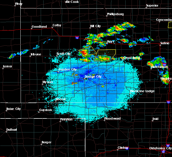 At 1233 am cdt, a severe thunderstorm was located 3 miles southwest of ransom, moving northeast at 30 mph (radar indicated). Hazards include 60 mph wind gusts and half dollar size hail. Hail damage to vehicles is expected. expect wind damage to roofs, siding, and trees. Locations impacted include, ransom, utica, brownell and arnold. At 1233 am cdt, a severe thunderstorm was located 3 miles southwest of ransom, moving northeast at 30 mph (radar indicated). Hazards include 60 mph wind gusts and half dollar size hail. Hail damage to vehicles is expected. expect wind damage to roofs, siding, and trees. Locations impacted include, ransom, utica, brownell and arnold.
|
| 7/12/2016 12:07 AM CDT |
 At 1207 am cdt, a severe thunderstorm was located 4 miles east of beeler, moving northeast at 30 mph (radar indicated). Hazards include 60 mph wind gusts and half dollar size hail. Hail damage to vehicles is expected. Expect wind damage to roofs, siding, and trees. At 1207 am cdt, a severe thunderstorm was located 4 miles east of beeler, moving northeast at 30 mph (radar indicated). Hazards include 60 mph wind gusts and half dollar size hail. Hail damage to vehicles is expected. Expect wind damage to roofs, siding, and trees.
|
| 7/5/2016 11:07 PM CDT |
 At 1107 pm cdt, severe thunderstorms were located along a line extending from 2 miles southeast of ogallah to 3 miles southwest of ransom to 3 miles northwest of alamota, moving southeast at 50 mph (radar indicated). Hazards include 70 mph wind gusts and half dollar size hail. Hail damage to vehicles is expected. expect considerable tree damage. wind damage is also likely to mobile homes, roofs and outbuildings. Locations impacted include, ness city, dighton, bazine, ransom, ogallah, utica, brownell, shields, trego center, pendennis, cedar bluff and arnold. At 1107 pm cdt, severe thunderstorms were located along a line extending from 2 miles southeast of ogallah to 3 miles southwest of ransom to 3 miles northwest of alamota, moving southeast at 50 mph (radar indicated). Hazards include 70 mph wind gusts and half dollar size hail. Hail damage to vehicles is expected. expect considerable tree damage. wind damage is also likely to mobile homes, roofs and outbuildings. Locations impacted include, ness city, dighton, bazine, ransom, ogallah, utica, brownell, shields, trego center, pendennis, cedar bluff and arnold.
|
| 7/5/2016 10:47 PM CDT |
 At 1046 pm cdt, a severe thunderstorm was located 9 miles west of trego center, moving southeast at 30 mph (radar indicated). Hazards include 70 mph wind gusts and half dollar size hail. Hail damage to vehicles is expected. expect considerable tree damage. Wind damage is also likely to mobile homes, roofs and outbuildings. At 1046 pm cdt, a severe thunderstorm was located 9 miles west of trego center, moving southeast at 30 mph (radar indicated). Hazards include 70 mph wind gusts and half dollar size hail. Hail damage to vehicles is expected. expect considerable tree damage. Wind damage is also likely to mobile homes, roofs and outbuildings.
|
| 6/25/2016 5:20 PM CDT | . in trego county KS, 6.3 miles SSW of Utica, KS |
| 6/17/2016 9:12 PM CDT |
 At 912 pm cdt, a severe thunderstorm was located near arnold, moving southeast at 20 mph (radar indicated). Hazards include 60 mph wind gusts and quarter size hail. Hail damage to vehicles is expected. expect wind damage to roofs, siding and trees. Locations impacted include, ness city, ransom, utica, brownell, arnold and pendennis. At 912 pm cdt, a severe thunderstorm was located near arnold, moving southeast at 20 mph (radar indicated). Hazards include 60 mph wind gusts and quarter size hail. Hail damage to vehicles is expected. expect wind damage to roofs, siding and trees. Locations impacted include, ness city, ransom, utica, brownell, arnold and pendennis.
|
| 6/17/2016 9:01 PM CDT | Quarter sized hail reported 1.3 miles SSW of Utica, KS, . |
| 6/17/2016 8:55 PM CDT |
 At 855 pm cdt, a severe thunderstorm was located very near utica, moving southeast at 20 mph (radar indicated). Hazards include 60 mph wind gusts and quarter size hail. Hail damage to vehicles is expected. Expect wind damage to roofs, siding and trees. At 855 pm cdt, a severe thunderstorm was located very near utica, moving southeast at 20 mph (radar indicated). Hazards include 60 mph wind gusts and quarter size hail. Hail damage to vehicles is expected. Expect wind damage to roofs, siding and trees.
|
| 5/24/2016 7:16 PM CDT | The national weather service in dodge city has issued a * severe thunderstorm warning for. southwestern trego county in west central kansas. northeastern lane county in west central kansas. northwestern ness county in west central kansas. Until 800 pm cdt. |
| 5/24/2016 5:56 PM CDT |
 At 555 pm cdt, a severe thunderstorm capable of producing a tornado was located 4 miles north of utica, moving east at 55 mph (radar indicated rotation). Hazards include tornado and two inch hail. Flying debris will be dangerous to those caught without shelter. mobile homes will be damaged or destroyed. damage to roofs, windows and vehicles will occur. tree damage is likely. Locations impacted include, ransom, utica, arnold and pendennis. At 555 pm cdt, a severe thunderstorm capable of producing a tornado was located 4 miles north of utica, moving east at 55 mph (radar indicated rotation). Hazards include tornado and two inch hail. Flying debris will be dangerous to those caught without shelter. mobile homes will be damaged or destroyed. damage to roofs, windows and vehicles will occur. tree damage is likely. Locations impacted include, ransom, utica, arnold and pendennis.
|
| 5/24/2016 5:44 PM CDT |
 At 543 pm cdt, a severe thunderstorm was located very near alamota, moving northeast at 40 mph (radar indicated). Hazards include ping pong ball size hail and 60 mph wind gusts. People and animals outdoors will be injured. expect hail damage to roofs, siding, windows and vehicles. expect wind damage to roofs, siding and trees. locations impacted include, utica, alamota, arnold, beeler and pendennis. A tornado watch remains in effect until midnight cdt for southwestern kansas. At 543 pm cdt, a severe thunderstorm was located very near alamota, moving northeast at 40 mph (radar indicated). Hazards include ping pong ball size hail and 60 mph wind gusts. People and animals outdoors will be injured. expect hail damage to roofs, siding, windows and vehicles. expect wind damage to roofs, siding and trees. locations impacted include, utica, alamota, arnold, beeler and pendennis. A tornado watch remains in effect until midnight cdt for southwestern kansas.
|
| 5/8/2016 5:51 PM CDT |
 The tornado warning for northwestern ness county will expire at 600 pm cdt, the tornadic thunderstorm which prompted the warning is moving out of the warned area. therefore the warning will be allowed to expire. a tornado watch remains in effect until 1000 pm cdt for west central kansas. The tornado warning for northwestern ness county will expire at 600 pm cdt, the tornadic thunderstorm which prompted the warning is moving out of the warned area. therefore the warning will be allowed to expire. a tornado watch remains in effect until 1000 pm cdt for west central kansas.
|
| 5/8/2016 5:46 PM CDT |
 At 546 pm cdt, a severe thunderstorm capable of producing a tornado was located 3 miles northwest of arnold, moving northeast at 35 mph (radar indicated rotation). Hazards include tornado and two inch hail. Flying debris will be dangerous to those caught without shelter. mobile homes will be damaged or destroyed. damage to roofs, windows and vehicles will occur. tree damage is likely. This tornadic thunderstorm will remain over mainly rural areas of northwestern ness county. At 546 pm cdt, a severe thunderstorm capable of producing a tornado was located 3 miles northwest of arnold, moving northeast at 35 mph (radar indicated rotation). Hazards include tornado and two inch hail. Flying debris will be dangerous to those caught without shelter. mobile homes will be damaged or destroyed. damage to roofs, windows and vehicles will occur. tree damage is likely. This tornadic thunderstorm will remain over mainly rural areas of northwestern ness county.
|
| 5/8/2016 5:37 PM CDT |
 At 537 pm cdt, a severe thunderstorm capable of producing a tornado was located 4 miles south of utica, moving northeast at 20 mph (radar indicated rotation). Hazards include tornado and hail up to two inches in diameter. Flying debris will be dangerous to those caught without shelter. mobile homes will be damaged or destroyed. damage to roofs, windows and vehicles will occur. tree damage is likely. this dangerous storm will be near, utica around 550 pm cdt. Arnold around 600 pm cdt. At 537 pm cdt, a severe thunderstorm capable of producing a tornado was located 4 miles south of utica, moving northeast at 20 mph (radar indicated rotation). Hazards include tornado and hail up to two inches in diameter. Flying debris will be dangerous to those caught without shelter. mobile homes will be damaged or destroyed. damage to roofs, windows and vehicles will occur. tree damage is likely. this dangerous storm will be near, utica around 550 pm cdt. Arnold around 600 pm cdt.
|
| 5/8/2016 5:32 PM CDT |
 At 532 pm cdt, a severe thunderstorm was located near utica, moving north at 25 mph (radar indicated). Hazards include two inch hail and 70 mph wind gusts. People and animals outdoors will be injured. expect hail damage to roofs, siding, windows and vehicles. expect considerable tree damage. Wind damage is also likely to mobile homes, roofs and outbuildings. At 532 pm cdt, a severe thunderstorm was located near utica, moving north at 25 mph (radar indicated). Hazards include two inch hail and 70 mph wind gusts. People and animals outdoors will be injured. expect hail damage to roofs, siding, windows and vehicles. expect considerable tree damage. Wind damage is also likely to mobile homes, roofs and outbuildings.
|
| 5/8/2016 5:21 PM CDT |
 At 521 pm cdt, a severe thunderstorm was located 4 miles northwest of alamota, moving north at 20 mph (radar indicated). Hazards include golf ball size hail and 60 mph wind gusts. People and animals outdoors will be injured. expect hail damage to roofs, siding, windows and vehicles. expect wind damage to roofs, siding and trees. locations impacted include, dighton, utica, alamota and pendennis. A tornado watch remains in effect until 1000 pm cdt for west central kansas. At 521 pm cdt, a severe thunderstorm was located 4 miles northwest of alamota, moving north at 20 mph (radar indicated). Hazards include golf ball size hail and 60 mph wind gusts. People and animals outdoors will be injured. expect hail damage to roofs, siding, windows and vehicles. expect wind damage to roofs, siding and trees. locations impacted include, dighton, utica, alamota and pendennis. A tornado watch remains in effect until 1000 pm cdt for west central kansas.
|
| 5/8/2016 5:12 PM CDT |
 At 512 pm cdt, a severe thunderstorm was located 4 miles east of dighton, moving north at 20 mph (radar indicated). Hazards include golf ball size hail and 60 mph wind gusts. People and animals outdoors will be injured. expect hail damage to roofs, siding, windows and vehicles. expect wind damage to roofs, siding and trees. locations impacted include, dighton, utica, alamota and pendennis. A tornado watch remains in effect until 1000 pm cdt for west central kansas. At 512 pm cdt, a severe thunderstorm was located 4 miles east of dighton, moving north at 20 mph (radar indicated). Hazards include golf ball size hail and 60 mph wind gusts. People and animals outdoors will be injured. expect hail damage to roofs, siding, windows and vehicles. expect wind damage to roofs, siding and trees. locations impacted include, dighton, utica, alamota and pendennis. A tornado watch remains in effect until 1000 pm cdt for west central kansas.
|
| 5/8/2016 5:04 PM CDT |
 At 504 pm cdt, a severe thunderstorm was located 5 miles southeast of dighton, moving northeast at 20 mph (radar indicated). Hazards include golf ball size hail and 60 mph wind gusts. People and animals outdoors will be injured. expect hail damage to roofs, siding, windows and vehicles. Expect wind damage to roofs, siding and trees. At 504 pm cdt, a severe thunderstorm was located 5 miles southeast of dighton, moving northeast at 20 mph (radar indicated). Hazards include golf ball size hail and 60 mph wind gusts. People and animals outdoors will be injured. expect hail damage to roofs, siding, windows and vehicles. Expect wind damage to roofs, siding and trees.
|
| 4/20/2016 5:45 PM CDT |
 At 545 pm cdt, a severe thunderstorm was located near arnold, moving east at 35 mph (radar indicated). Hazards include quarter size hail. Damage to vehicles is expected. Locations impacted include, ransom, utica and arnold. At 545 pm cdt, a severe thunderstorm was located near arnold, moving east at 35 mph (radar indicated). Hazards include quarter size hail. Damage to vehicles is expected. Locations impacted include, ransom, utica and arnold.
|
| 4/20/2016 5:24 PM CDT |
 At 524 pm cdt, a severe thunderstorm was located very near pendennis, moving east at 35 mph (radar indicated). Hazards include 60 mph wind gusts and quarter size hail. Hail damage to vehicles is expected. Expect wind damage to roofs, siding and trees. At 524 pm cdt, a severe thunderstorm was located very near pendennis, moving east at 35 mph (radar indicated). Hazards include 60 mph wind gusts and quarter size hail. Hail damage to vehicles is expected. Expect wind damage to roofs, siding and trees.
|
| 11/16/2015 6:06 PM CST |
 At 605 pm cst, a large and extremely dangerous tornado was located 5 miles south of beeler, moving northeast at 40 mph. this is a particularly dangerous situation (radar indicated rotation). Hazards include damaging tornado. Flying debris will be dangerous to those caught without shelter. mobile homes will be damaged or destroyed. damage to roofs, windows and vehicles will occur. tree damage is likely. Locations impacted include, ness city, utica, beeler and arnold. At 605 pm cst, a large and extremely dangerous tornado was located 5 miles south of beeler, moving northeast at 40 mph. this is a particularly dangerous situation (radar indicated rotation). Hazards include damaging tornado. Flying debris will be dangerous to those caught without shelter. mobile homes will be damaged or destroyed. damage to roofs, windows and vehicles will occur. tree damage is likely. Locations impacted include, ness city, utica, beeler and arnold.
|
| 11/16/2015 5:48 PM CST |
 At 547 pm cst, a severe thunderstorm capable of producing a tornado was located 12 miles north of kalvesta, moving northeast at 40 mph (radar indicated rotation. rural locations of eastern finney and southern lane counties are in the path of this tornado). Hazards include tornado and two inch hail. Flying debris will be dangerous to those caught without shelter. mobile homes will be damaged or destroyed. damage to roofs, windows and vehicles will occur. tree damage is likely. Locations impacted include, ness city, utica, alamota, beeler and arnold. At 547 pm cst, a severe thunderstorm capable of producing a tornado was located 12 miles north of kalvesta, moving northeast at 40 mph (radar indicated rotation. rural locations of eastern finney and southern lane counties are in the path of this tornado). Hazards include tornado and two inch hail. Flying debris will be dangerous to those caught without shelter. mobile homes will be damaged or destroyed. damage to roofs, windows and vehicles will occur. tree damage is likely. Locations impacted include, ness city, utica, alamota, beeler and arnold.
|
| 11/16/2015 5:34 PM CST |
 At 534 pm cst, a severe thunderstorm capable of producing a tornado was located 9 miles northwest of kalvesta, moving northeast at 55 mph (radar indicated rotation). Hazards include tornado and hail up to two inches in diameter. Flying debris will be dangerous to those caught without shelter. mobile homes will be damaged or destroyed. damage to roofs, windows and vehicles will occur. Tree damage is likely. At 534 pm cst, a severe thunderstorm capable of producing a tornado was located 9 miles northwest of kalvesta, moving northeast at 55 mph (radar indicated rotation). Hazards include tornado and hail up to two inches in diameter. Flying debris will be dangerous to those caught without shelter. mobile homes will be damaged or destroyed. damage to roofs, windows and vehicles will occur. Tree damage is likely.
|
| 9/10/2015 7:02 PM CDT |
 At 701 pm cdt, a severe thunderstorm was located 5 miles northwest of ness city, moving southeast at 15 mph. this is a very dangerous storm (radar indicated). Hazards include 80 mph wind gusts and quarter size hail. Flying debris will be dangerous to those caught without shelter. mobile homes will be heavily damaged. expect considerable damage to roofs, windows and vehicles. extensive tree damage and power outages are likely. Locations impacted include, ness city, ransom, utica and arnold. At 701 pm cdt, a severe thunderstorm was located 5 miles northwest of ness city, moving southeast at 15 mph. this is a very dangerous storm (radar indicated). Hazards include 80 mph wind gusts and quarter size hail. Flying debris will be dangerous to those caught without shelter. mobile homes will be heavily damaged. expect considerable damage to roofs, windows and vehicles. extensive tree damage and power outages are likely. Locations impacted include, ness city, ransom, utica and arnold.
|
| 9/10/2015 6:42 PM CDT | Tree limbs up to five inches in diameter were blown dow in ness county KS, 6 miles W of Utica, KS |
| 9/10/2015 6:42 PM CDT |
 At 642 pm cdt, a severe thunderstorm was located 3 miles southeast of arnold, moving southeast at 15 mph (radar indicated). Hazards include golf ball size hail and 60 mph wind gusts. People and animals outdoors will be injured. expect hail damage to roofs, siding, windows and vehicles. Expect wind damage to roofs, siding and trees. At 642 pm cdt, a severe thunderstorm was located 3 miles southeast of arnold, moving southeast at 15 mph (radar indicated). Hazards include golf ball size hail and 60 mph wind gusts. People and animals outdoors will be injured. expect hail damage to roofs, siding, windows and vehicles. Expect wind damage to roofs, siding and trees.
|
| 7/26/2015 10:41 PM CDT |
 At 1041 pm cdt, severe thunderstorms were located along a line extending from 2 miles west of ransom to 10 miles northeast of kalvesta, moving east at 30 mph (radar indicated). Hazards include 70 mph wind gusts and penny size hail. Expect considerable tree damage. damage is likely to mobile homes, roofs and outbuildings. Locations impacted include, gray, ness city, dighton, jetmore, bazine, ransom, hanston, utica, alamota, brownell, arnold, beeler, shields and pendennis. At 1041 pm cdt, severe thunderstorms were located along a line extending from 2 miles west of ransom to 10 miles northeast of kalvesta, moving east at 30 mph (radar indicated). Hazards include 70 mph wind gusts and penny size hail. Expect considerable tree damage. damage is likely to mobile homes, roofs and outbuildings. Locations impacted include, gray, ness city, dighton, jetmore, bazine, ransom, hanston, utica, alamota, brownell, arnold, beeler, shields and pendennis.
|
| 7/26/2015 10:16 PM CDT |
 At 1015 pm cdt, a severe thunderstorm was located 5 miles southwest of alamota, moving east at 40 mph (radar indicated). Hazards include 70 mph wind gusts and nickel size hail. Expect considerable tree damage. Damage is likely to mobile homes, roofs and outbuildings. At 1015 pm cdt, a severe thunderstorm was located 5 miles southwest of alamota, moving east at 40 mph (radar indicated). Hazards include 70 mph wind gusts and nickel size hail. Expect considerable tree damage. Damage is likely to mobile homes, roofs and outbuildings.
|
| 7/19/2015 9:59 PM CDT |
 At 959 pm cdt, severe thunderstorms were located along a line extending from 4 miles northwest of utica to 9 miles south of beeler, moving east at 30 mph (radar indicated). Hazards include 60 mph wind gusts. Expect damage to roofs. Siding and trees. At 959 pm cdt, severe thunderstorms were located along a line extending from 4 miles northwest of utica to 9 miles south of beeler, moving east at 30 mph (radar indicated). Hazards include 60 mph wind gusts. Expect damage to roofs. Siding and trees.
|
| 7/19/2015 3:23 AM CDT |
 The severe thunderstorm warning for trego, northern ness and northeastern lane counties will expire at 330 am cdt, the storm which prompted the warning has weakened below severe limits and exited the warned area. therefore the warning will be allowed to expire. however gusty winds and heavy rain are still possible with this thunderstorm. The severe thunderstorm warning for trego, northern ness and northeastern lane counties will expire at 330 am cdt, the storm which prompted the warning has weakened below severe limits and exited the warned area. therefore the warning will be allowed to expire. however gusty winds and heavy rain are still possible with this thunderstorm.
|
| 7/19/2015 2:31 AM CDT |
 At 230 am cdt, a severe thunderstorm was located 3 miles northeast of pendennis, moving east at 25 mph (radar indicated). Hazards include 60 mph wind gusts and nickel size hail. Expect damage to roofs. Siding and trees. At 230 am cdt, a severe thunderstorm was located 3 miles northeast of pendennis, moving east at 25 mph (radar indicated). Hazards include 60 mph wind gusts and nickel size hail. Expect damage to roofs. Siding and trees.
|
| 6/4/2015 7:50 PM CDT | At 750 pm cdt, a severe thunderstorm was located 4 miles northeast of shields, moving west at 5 mph (radar indicated). Hazards include 60 mph wind gusts and half dollar size hail. Hail damage to vehicles is expected. expect wind damage to roofs, siding and trees. locations impacted include, utica and pendennis. A tornado watch remains in effect until 200 am cdt for west central kansas. |
| 6/4/2015 7:27 PM CDT | At 726 pm cdt, a severe thunderstorm was located near pendennis, moving northeast at 20 mph (the public reported quarter sized hail 13 miles northeast of dighton). Hazards include ping pong ball size hail and 60 mph wind gusts. People and animals outdoors will be injured. expect hail damage to roofs, siding, windows and vehicles. expect wind damage to roofs, siding and trees. locations impacted include, utica, pendennis and shields. A tornado watch remains in effect until 200 am cdt for west central kansas. |
| 6/4/2015 7:15 PM CDT | At 715 pm cdt, a severe thunderstorm was located near shields, moving east at 5 mph (radar indicated). Hazards include golf ball size hail and 60 mph wind gusts. People and animals outdoors will be injured. expect hail damage to roofs, siding, windows and vehicles. Expect wind damage to roofs, siding and trees. |
| 5/28/2015 6:52 PM CDT | The severe thunderstorm warning for hodgeman, ness, northeastern finney and eastern lane counties will expire at 700 pm cdt, the storm which prompted the warning has weakened below severe limits, and no longer pose an immediate threat to life or property. therefore the warning will be allowed to expire. however gusty winds and heavy rain are still possible with this thunderstorm. |
| 5/28/2015 6:24 PM CDT | At 624 pm cdt, a severe thunderstorm was located 9 miles southwest of ness city, moving east at 45 mph (radar indicated). Hazards include 60 mph wind gusts and quarter size hail. Hail damage to vehicles is expected. expect wind damage to roofs, siding and trees. Locations impacted include, gray, ness city, dighton, jetmore, bazine, ransom, hanston, utica, alamota, brownell, arnold, beeler and pendennis. |
| 5/28/2015 6:11 PM CDT | Storm damage reported in ness county KS, 3.4 miles ESE of Utica, KS |
| 5/28/2015 5:59 PM CDT | At 559 pm cdt, a severe thunderstorm was located 4 miles southwest of alamota, moving east at 50 mph (radar indicated). Hazards include 60 mph wind gusts and quarter size hail. Hail damage to vehicles is expected. Expect wind damage to roofs, siding and trees. |
| 4/24/2015 7:25 PM CDT | Quarter sized hail reported 10.6 miles SW of Utica, KS |
| 4/17/2015 6:54 PM CDT | At 654 pm cdt, a severe thunderstorm was located near beeler, moving northeast at 30 mph (radar indicated). Hazards include half dollar size hail. damage to vehicles is expected |
| 4/2/2015 9:36 PM CDT | A severe thunderstorm warning remains in effect until 1015 pm cdt for southern trego. northwestern rush. northwestern hodgeman. ness. northeastern finney. northeastern gray. southwestern ellis and southeastern lane counties. at 934 pm cdt. Severe thunderstorms were located along a line extending from near arnold to near beeler to 14 miles west of. |
| 4/2/2015 9:20 PM CDT | The national weather service in dodge city has issued a * severe thunderstorm warning for. southern trego county in west central kansas. northwestern rush county in central kansas. northwestern hodgeman county in southwestern kansas. Ness county in west central kansas. |
| 6/29/2014 7:25 AM CDT | A few small tree limbs were dow in ness county KS, 7.4 miles NNE of Utica, KS |
| 7/9/2013 5:35 PM CDT | The kansas highway patrol reported a semitrailer was blown over on highway 96 and mile marker 10 in ness county KS, 13.4 miles N of Utica, KS |
| 5/18/2013 4:26 PM CDT | Hen Egg sized hail reported 3.2 miles E of Utica, KS, the caller reported hail as bigger than golfball. |
| 5/18/2013 4:25 PM CDT | Quarter sized hail reported 0.2 miles N of Utica, KS |
| 5/18/2013 4:13 PM CDT | Golf Ball sized hail reported 3.6 miles NE of Utica, KS |
| 5/7/2013 6:57 PM CDT | Half Dollar sized hail reported 6.6 miles NNW of Utica, KS, they received a measured 1.05 inches of rain. |
| 5/7/2013 6:45 PM CDT | Half Dollar sized hail reported 6.5 miles N of Utica, KS |
| 9/6/2012 5:45 PM CDT | Ping Pong Ball sized hail reported 4.4 miles ENE of Utica, KS |
| 9/6/2012 5:36 PM CDT | Storm damage reported in lane county KS, 9.2 miles E of Utica, KS |
| 1/1/0001 12:00 AM | Homeowner lost the roof off a barn and most farm outbuildings have damage. estimated winds gust of 70 mp in ness county KS, 3.4 miles ESE of Utica, KS |
| 1/1/0001 12:00 AM | Golf Ball sized hail reported 7.4 miles NNE of Utica, KS |
Hail Maps for Utica, KS
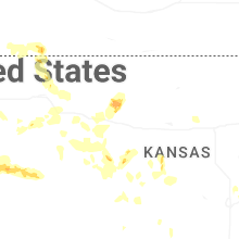
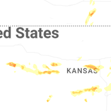
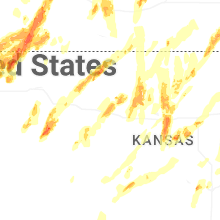


Connect with Interactive Hail Maps