

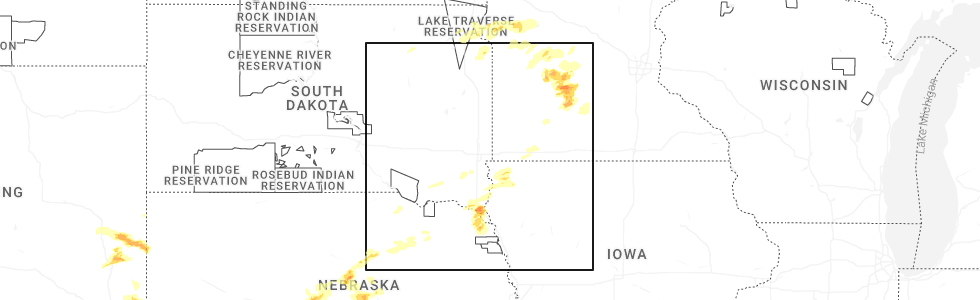
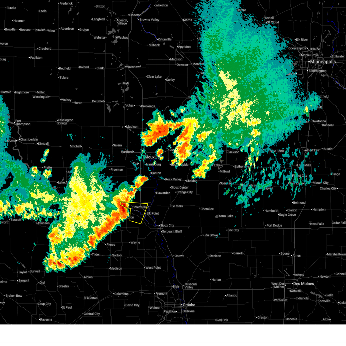
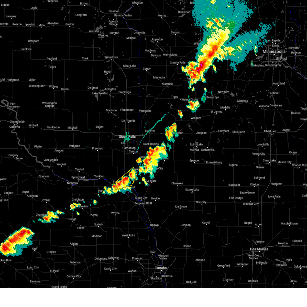
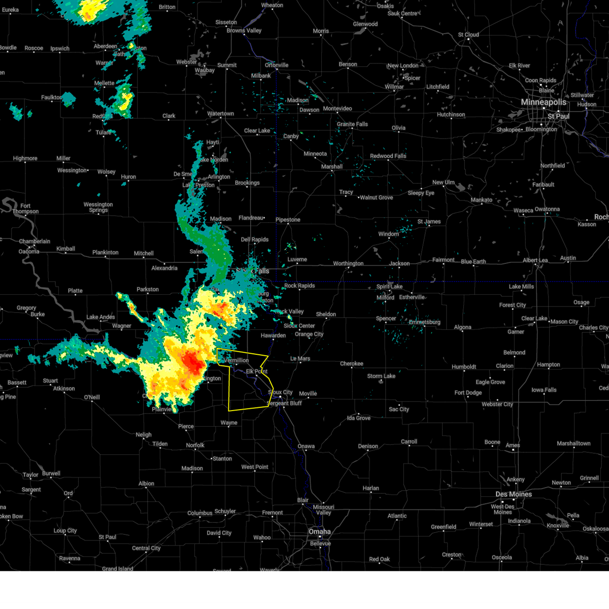
Hail Map for Vermillion, SD
The Vermillion, SD area has had 19 reports of on-the-ground hail by trained spotters, and has been under severe weather warnings 12 times during the past 12 months. Doppler radar has detected hail at or near Vermillion, SD on 71 occasions, including 4 occasions during the past year.
| Name: | Vermillion, SD |
| Where Located: | 53.4 miles S of Sioux Falls, SD |
| Map: | Google Map for Vermillion, SD |
| Population: | 10571 |
| Housing Units: | 4043 |
| More Info: | Search Google for Vermillion, SD |
2
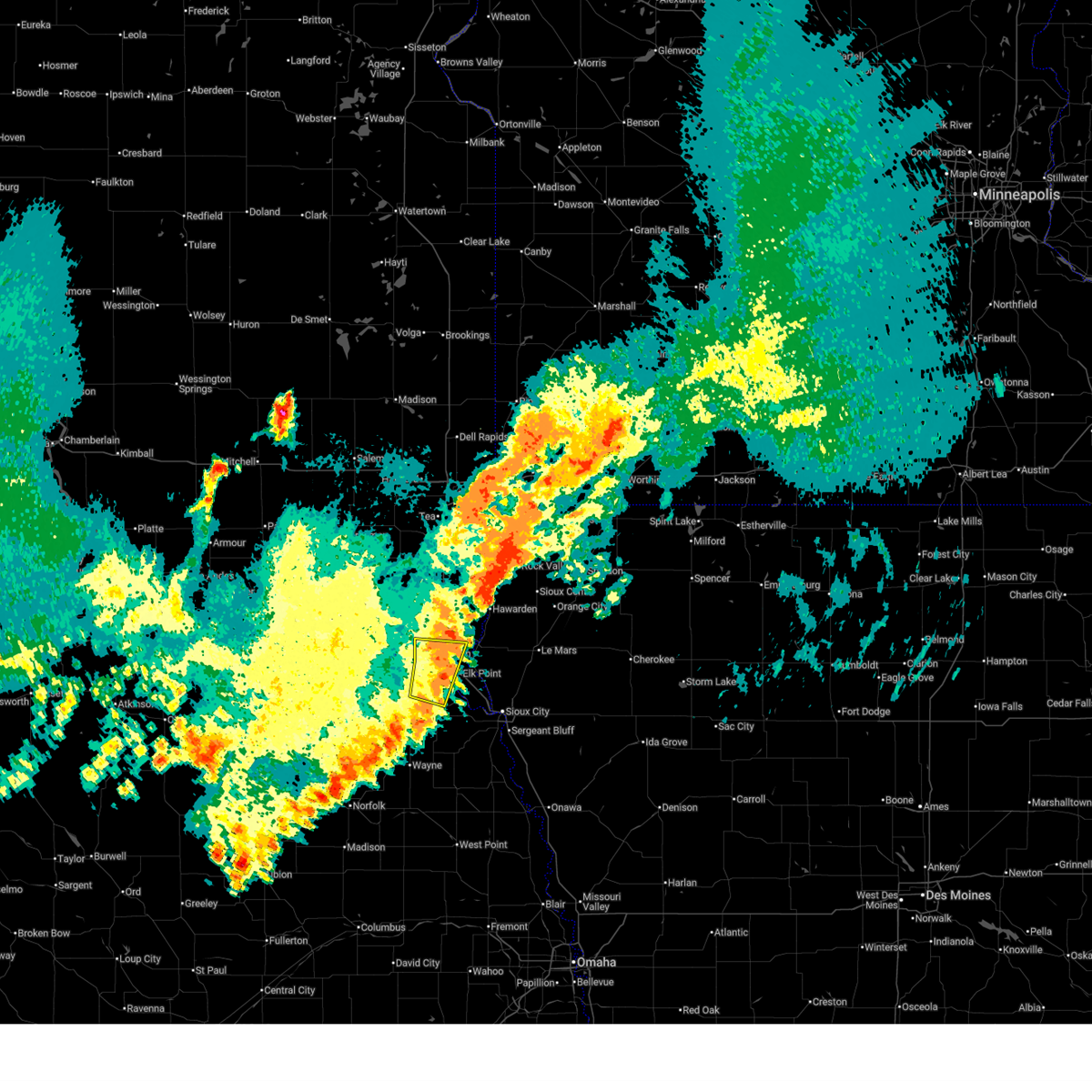
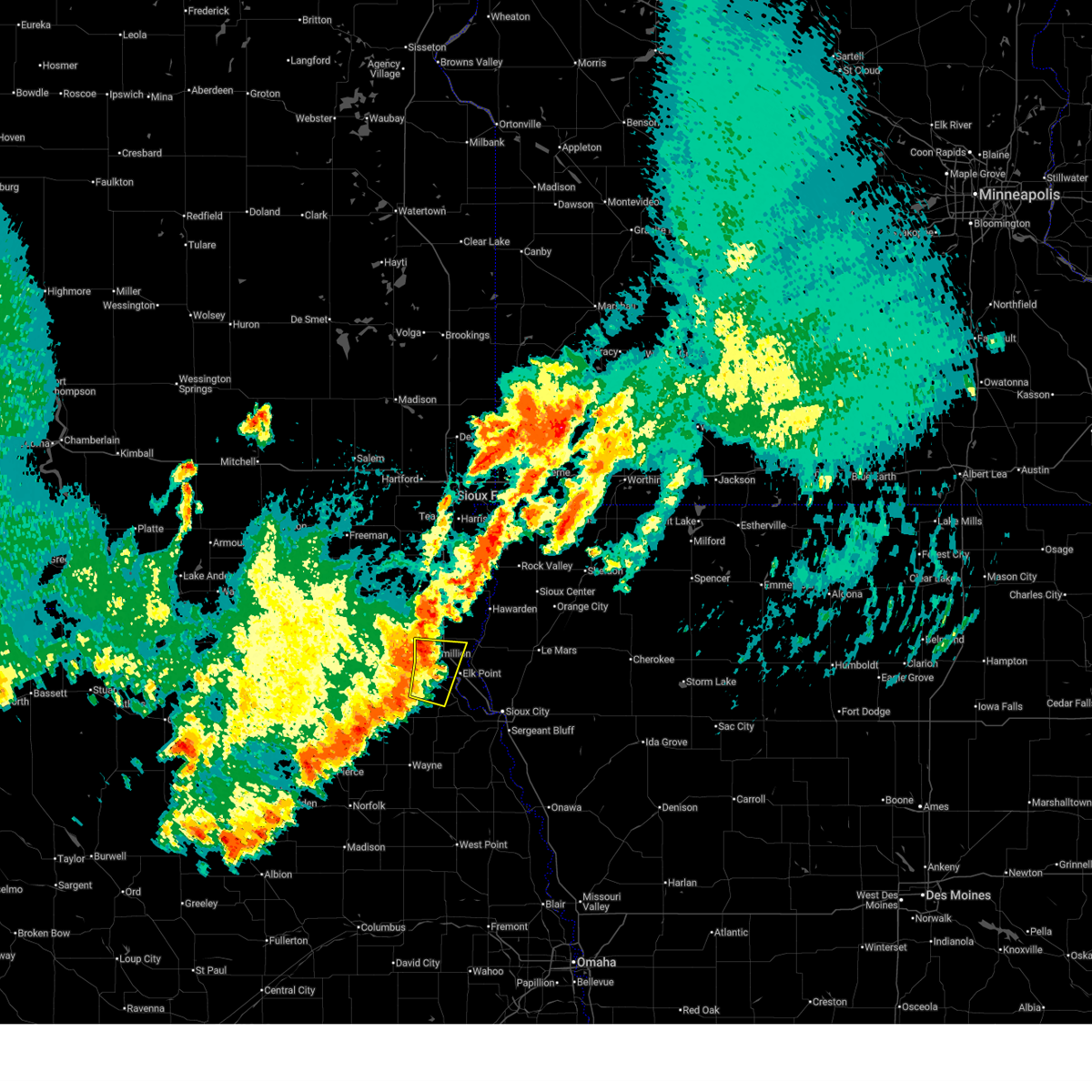
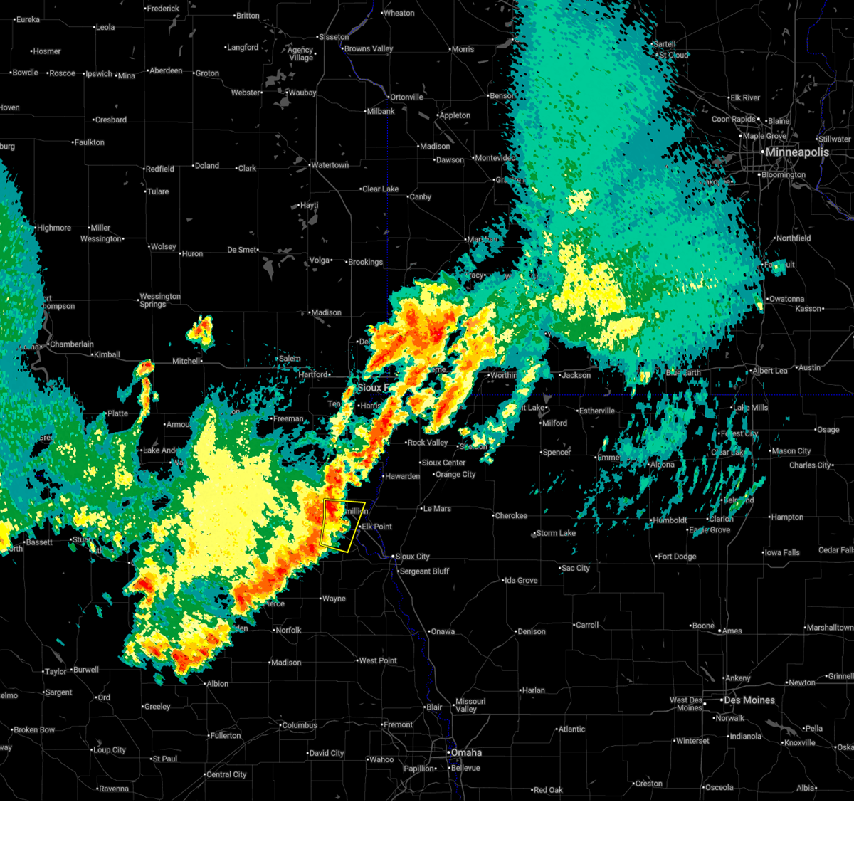
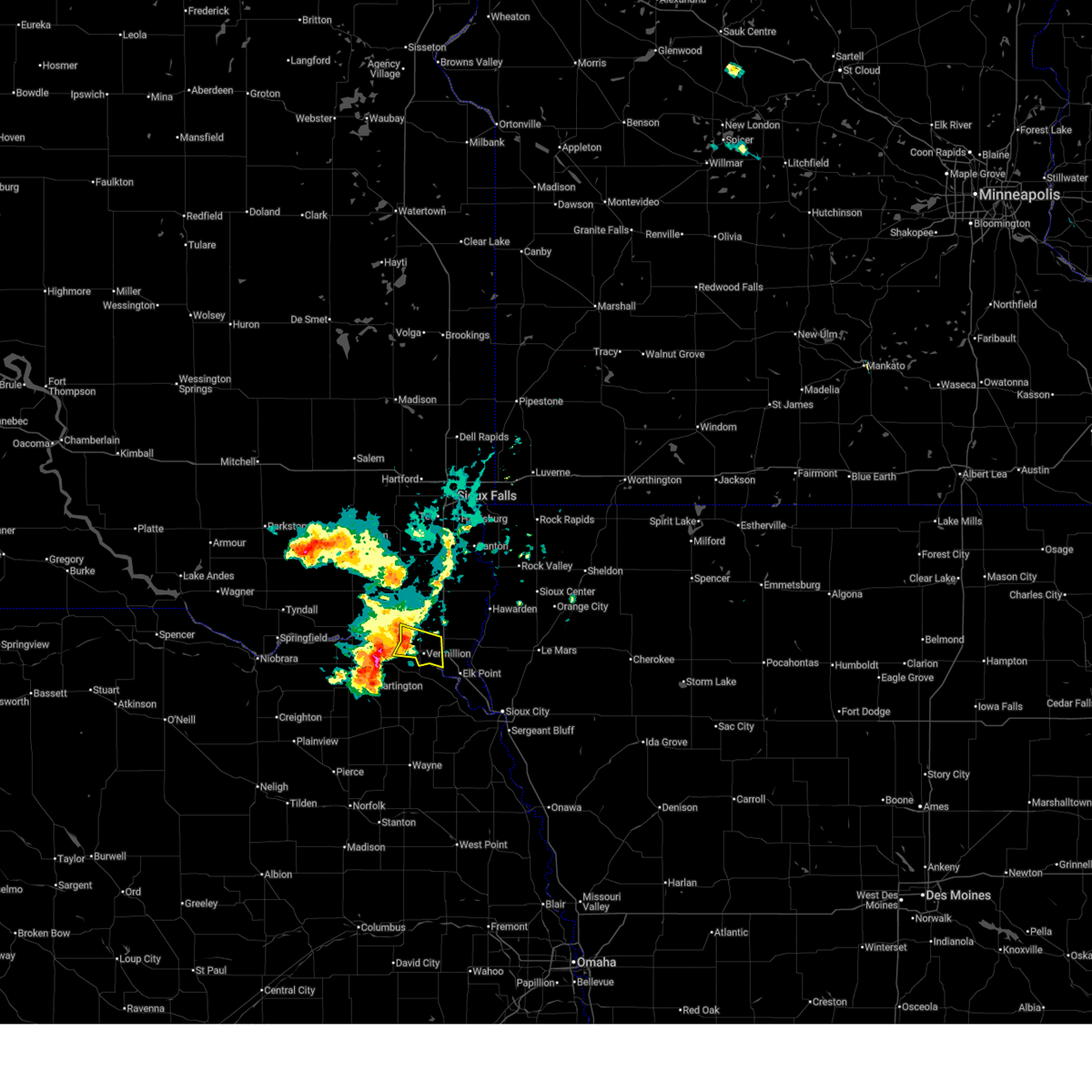
The Top Recent Hail Date for Vermillion, SD is Monday, June 2, 2025 (5th out of 71)
Hail and Wind Damage Spotted near Vermillion, SD
| Date / Time | Report Details |
|---|---|
| 6/29/2025 3:16 AM CDT |
 the severe thunderstorm warning has been cancelled and is no longer in effect the severe thunderstorm warning has been cancelled and is no longer in effect
|
| 6/29/2025 3:00 AM CDT |
 the severe thunderstorm warning has been cancelled and is no longer in effect the severe thunderstorm warning has been cancelled and is no longer in effect
|
| 6/29/2025 3:00 AM CDT |
 At 300 am cdt, severe thunderstorms were located along a line extending from near vermillion to near newcastle to near martinsburg, moving east at 30 mph (radar indicated). Hazards include 60 mph wind gusts. Expect damage to roofs, siding, and trees. These severe thunderstorms will remain over mainly rural areas of northwestern dixon, southeastern clay and west central union counties. At 300 am cdt, severe thunderstorms were located along a line extending from near vermillion to near newcastle to near martinsburg, moving east at 30 mph (radar indicated). Hazards include 60 mph wind gusts. Expect damage to roofs, siding, and trees. These severe thunderstorms will remain over mainly rural areas of northwestern dixon, southeastern clay and west central union counties.
|
| 6/29/2025 2:42 AM CDT |
 Svrfsd the national weather service in sioux falls has issued a * severe thunderstorm warning for, northwestern dixon county in northeastern nebraska, southern clay county in southeastern south dakota, southeastern yankton county in southeastern south dakota, west central union county in southeastern south dakota, * until 330 am cdt. * at 242 am cdt, a severe thunderstorm was located near wynot, or 9 miles west of vermillion, moving east at 30 mph (radar indicated). Hazards include 60 mph wind gusts. Expect damage to roofs, siding, and trees. this severe thunderstorm will be near, vermillion, meckling, and maskell around 245 am cdt. Newcastle around 255 am cdt. Svrfsd the national weather service in sioux falls has issued a * severe thunderstorm warning for, northwestern dixon county in northeastern nebraska, southern clay county in southeastern south dakota, southeastern yankton county in southeastern south dakota, west central union county in southeastern south dakota, * until 330 am cdt. * at 242 am cdt, a severe thunderstorm was located near wynot, or 9 miles west of vermillion, moving east at 30 mph (radar indicated). Hazards include 60 mph wind gusts. Expect damage to roofs, siding, and trees. this severe thunderstorm will be near, vermillion, meckling, and maskell around 245 am cdt. Newcastle around 255 am cdt.
|
| 6/16/2025 4:01 PM CDT |
 the severe thunderstorm warning has been cancelled and is no longer in effect the severe thunderstorm warning has been cancelled and is no longer in effect
|
| 6/16/2025 4:01 PM CDT |
 At 400 pm cdt, a severe thunderstorm was located over vermillion, moving southeast at 40 mph (radar indicated). Hazards include 60 mph wind gusts and quarter size hail. Hail damage to vehicles is expected. expect wind damage to roofs, siding, and trees. This severe storm will be near, vermillion around 405 pm cdt. At 400 pm cdt, a severe thunderstorm was located over vermillion, moving southeast at 40 mph (radar indicated). Hazards include 60 mph wind gusts and quarter size hail. Hail damage to vehicles is expected. expect wind damage to roofs, siding, and trees. This severe storm will be near, vermillion around 405 pm cdt.
|
| 6/16/2025 3:47 PM CDT |
 Svrfsd the national weather service in sioux falls has issued a * severe thunderstorm warning for, southern clay county in southeastern south dakota, southeastern yankton county in southeastern south dakota, * until 415 pm cdt. * at 347 pm cdt, a severe thunderstorm was located near meckling, or 11 miles west of vermillion, moving southeast at 40 mph (radar indicated). Hazards include 60 mph wind gusts and quarter size hail. Hail damage to vehicles is expected. expect wind damage to roofs, siding, and trees. This severe thunderstorm will be near, vermillion and meckling around 350 pm cdt. Svrfsd the national weather service in sioux falls has issued a * severe thunderstorm warning for, southern clay county in southeastern south dakota, southeastern yankton county in southeastern south dakota, * until 415 pm cdt. * at 347 pm cdt, a severe thunderstorm was located near meckling, or 11 miles west of vermillion, moving southeast at 40 mph (radar indicated). Hazards include 60 mph wind gusts and quarter size hail. Hail damage to vehicles is expected. expect wind damage to roofs, siding, and trees. This severe thunderstorm will be near, vermillion and meckling around 350 pm cdt.
|
| 6/14/2025 6:35 PM CDT | Half Dollar sized hail reported 8 miles WSW of Vermillion, SD |
| 6/2/2025 5:54 PM CDT | Tree and structure damage to an agricultural themed event venue. fence at property also blown over. additional damage 1 mile southeast of property on burbank road to ne in union county SD, 7.6 miles WNW of Vermillion, SD |
| 6/2/2025 5:44 PM CDT | The storm which prompted the warning has weakened below severe limits, and no longer poses an immediate threat to life or property. therefore, the warning will be allowed to expire. a severe thunderstorm watch remains in effect until 100 am cdt for northwestern iowa, and southeastern south dakota. |
| 6/2/2025 5:26 PM CDT |
 the severe thunderstorm warning has been cancelled and is no longer in effect the severe thunderstorm warning has been cancelled and is no longer in effect
|
| 6/2/2025 5:26 PM CDT |
 At 525 pm cdt, a severe thunderstorm was located near vermillion, moving east at 30 mph (radar indicated). Hazards include 60 mph wind gusts and quarter size hail. Hail damage to vehicles is expected. expect wind damage to roofs, siding, and trees. This severe storm will be near, union grove state park around 530 pm cdt. At 525 pm cdt, a severe thunderstorm was located near vermillion, moving east at 30 mph (radar indicated). Hazards include 60 mph wind gusts and quarter size hail. Hail damage to vehicles is expected. expect wind damage to roofs, siding, and trees. This severe storm will be near, union grove state park around 530 pm cdt.
|
| 6/2/2025 5:22 PM CDT | Quarter sized hail reported 0.3 miles SSE of Vermillion, SD, report via social media. |
| 6/2/2025 5:21 PM CDT | Quarter sized hail reported 0.6 miles NW of Vermillion, SD |
| 6/2/2025 5:21 PM CDT | Storage building destroyed by severe winds. 2.4 inches of rainfall in 15 to 20 minutes. pea to dime sized hai in clay county SD, 0.7 miles ESE of Vermillion, SD |
| 6/2/2025 5:20 PM CDT | Several large trees limbs down along with one large tree leaning on a house. winds estimated at least 60 mp in clay county SD, 0.7 miles ENE of Vermillion, SD |
| 6/2/2025 5:16 PM CDT |
 Svrfsd the national weather service in sioux falls has issued a * severe thunderstorm warning for, northwestern dixon county in northeastern nebraska, southeastern clay county in southeastern south dakota, northern union county in southeastern south dakota, * until 545 pm cdt. * at 516 pm cdt, a severe thunderstorm was located over vermillion, moving east at 30 mph (radar indicated). Hazards include 60 mph wind gusts and quarter size hail. Hail damage to vehicles is expected. expect wind damage to roofs, siding, and trees. This severe thunderstorm will be near, union grove state park around 525 pm cdt. Svrfsd the national weather service in sioux falls has issued a * severe thunderstorm warning for, northwestern dixon county in northeastern nebraska, southeastern clay county in southeastern south dakota, northern union county in southeastern south dakota, * until 545 pm cdt. * at 516 pm cdt, a severe thunderstorm was located over vermillion, moving east at 30 mph (radar indicated). Hazards include 60 mph wind gusts and quarter size hail. Hail damage to vehicles is expected. expect wind damage to roofs, siding, and trees. This severe thunderstorm will be near, union grove state park around 525 pm cdt.
|
| 4/28/2025 7:17 PM CDT | Quarter sized hail reported 11.3 miles ESE of Vermillion, SD |
| 7/29/2024 10:44 PM CDT |
 Svrfsd the national weather service in sioux falls has issued a * severe thunderstorm warning for, northwestern dakota county in northeastern nebraska, dixon county in northeastern nebraska, southern clay county in southeastern south dakota, southern union county in southeastern south dakota, * until 1130 pm cdt. * at 1044 pm cdt, a severe thunderstorm was located over wynot, or 10 miles northeast of hartington, moving east at 60 mph (radar indicated). Hazards include 60 mph wind gusts and quarter size hail. Hail damage to vehicles is expected. expect wind damage to roofs, siding, and trees. this severe thunderstorm will be near, vermillion, meckling, and maskell around 1050 pm cdt. newcastle around 1055 pm cdt. elk point around 1100 pm cdt. Other locations in the path of this severe thunderstorm include ponca state park, ponca, jefferson and north sioux city. Svrfsd the national weather service in sioux falls has issued a * severe thunderstorm warning for, northwestern dakota county in northeastern nebraska, dixon county in northeastern nebraska, southern clay county in southeastern south dakota, southern union county in southeastern south dakota, * until 1130 pm cdt. * at 1044 pm cdt, a severe thunderstorm was located over wynot, or 10 miles northeast of hartington, moving east at 60 mph (radar indicated). Hazards include 60 mph wind gusts and quarter size hail. Hail damage to vehicles is expected. expect wind damage to roofs, siding, and trees. this severe thunderstorm will be near, vermillion, meckling, and maskell around 1050 pm cdt. newcastle around 1055 pm cdt. elk point around 1100 pm cdt. Other locations in the path of this severe thunderstorm include ponca state park, ponca, jefferson and north sioux city.
|
| 6/18/2024 6:32 PM CDT |
 the severe thunderstorm warning has been cancelled and is no longer in effect the severe thunderstorm warning has been cancelled and is no longer in effect
|
| 6/18/2024 6:16 PM CDT |
 Svrfsd the national weather service in sioux falls has issued a * severe thunderstorm warning for, southeastern clay county in southeastern south dakota, southern lincoln county in southeastern south dakota, northwestern union county in southeastern south dakota, * until 645 pm cdt. * at 616 pm cdt, a severe thunderstorm was located over meckling, or near vermillion, moving northeast at 40 mph (radar indicated). Hazards include 60 mph wind gusts and quarter size hail. Hail damage to vehicles is expected. expect wind damage to roofs, siding, and trees. this severe thunderstorm will be near, union grove state park around 625 pm cdt. Beresford around 635 pm cdt. Svrfsd the national weather service in sioux falls has issued a * severe thunderstorm warning for, southeastern clay county in southeastern south dakota, southern lincoln county in southeastern south dakota, northwestern union county in southeastern south dakota, * until 645 pm cdt. * at 616 pm cdt, a severe thunderstorm was located over meckling, or near vermillion, moving northeast at 40 mph (radar indicated). Hazards include 60 mph wind gusts and quarter size hail. Hail damage to vehicles is expected. expect wind damage to roofs, siding, and trees. this severe thunderstorm will be near, union grove state park around 625 pm cdt. Beresford around 635 pm cdt.
|
| 5/20/2024 10:40 PM CDT |
 At 1039 pm cdt, a severe thunderstorm was located near newcastle, or 8 miles northwest of ponca, moving east at 25 mph (trained weather spotters. at 1030 pm cdt quarter to golf ball sized hail was reported in new castle). Hazards include two inch hail and 60 mph wind gusts. People and animals outdoors will be injured. expect hail damage to roofs, siding, windows, and vehicles. expect wind damage to roofs, siding, and trees. This severe storm will be near, ponca, elk point, and ponca state park around 1045 pm cdt. At 1039 pm cdt, a severe thunderstorm was located near newcastle, or 8 miles northwest of ponca, moving east at 25 mph (trained weather spotters. at 1030 pm cdt quarter to golf ball sized hail was reported in new castle). Hazards include two inch hail and 60 mph wind gusts. People and animals outdoors will be injured. expect hail damage to roofs, siding, windows, and vehicles. expect wind damage to roofs, siding, and trees. This severe storm will be near, ponca, elk point, and ponca state park around 1045 pm cdt.
|
| 5/20/2024 10:31 PM CDT |
 At 1031 pm cdt, a severe thunderstorm was located over newcastle, or 8 miles southeast of vermillion, moving east at 25 mph (radar indicated). Hazards include two inch hail and 60 mph wind gusts. People and animals outdoors will be injured. expect hail damage to roofs, siding, windows, and vehicles. expect wind damage to roofs, siding, and trees. this severe storm will be near, elk point and ponca state park around 1035 pm cdt. Ponca around 1045 pm cdt. At 1031 pm cdt, a severe thunderstorm was located over newcastle, or 8 miles southeast of vermillion, moving east at 25 mph (radar indicated). Hazards include two inch hail and 60 mph wind gusts. People and animals outdoors will be injured. expect hail damage to roofs, siding, windows, and vehicles. expect wind damage to roofs, siding, and trees. this severe storm will be near, elk point and ponca state park around 1035 pm cdt. Ponca around 1045 pm cdt.
|
| 5/20/2024 10:26 PM CDT |
 Svrfsd the national weather service in sioux falls has issued a * severe thunderstorm warning for, northern dixon county in northeastern nebraska, southeastern clay county in southeastern south dakota, southwestern union county in southeastern south dakota, * until 1100 pm cdt. * at 1026 pm cdt, a severe thunderstorm was located over newcastle, or 8 miles south of vermillion, moving east at 25 mph (radar indicated). Hazards include ping pong ball size hail and 60 mph wind gusts. People and animals outdoors will be injured. expect hail damage to roofs, siding, windows, and vehicles. expect wind damage to roofs, siding, and trees. this severe thunderstorm will be near, vermillion, newcastle, and ponca state park around 1030 pm cdt. elk point around 1035 pm cdt. Ponca around 1040 pm cdt. Svrfsd the national weather service in sioux falls has issued a * severe thunderstorm warning for, northern dixon county in northeastern nebraska, southeastern clay county in southeastern south dakota, southwestern union county in southeastern south dakota, * until 1100 pm cdt. * at 1026 pm cdt, a severe thunderstorm was located over newcastle, or 8 miles south of vermillion, moving east at 25 mph (radar indicated). Hazards include ping pong ball size hail and 60 mph wind gusts. People and animals outdoors will be injured. expect hail damage to roofs, siding, windows, and vehicles. expect wind damage to roofs, siding, and trees. this severe thunderstorm will be near, vermillion, newcastle, and ponca state park around 1030 pm cdt. elk point around 1035 pm cdt. Ponca around 1040 pm cdt.
|
| 5/20/2024 10:14 PM CDT |
 At 1014 pm cdt, a severe thunderstorm was located over maskell, or 7 miles south of vermillion, moving east at 25 mph (radar indicated). Hazards include 60 mph wind gusts and quarter size hail. Hail damage to vehicles is expected. expect wind damage to roofs, siding, and trees. This severe storm will be near, vermillion and newcastle around 1020 pm cdt. At 1014 pm cdt, a severe thunderstorm was located over maskell, or 7 miles south of vermillion, moving east at 25 mph (radar indicated). Hazards include 60 mph wind gusts and quarter size hail. Hail damage to vehicles is expected. expect wind damage to roofs, siding, and trees. This severe storm will be near, vermillion and newcastle around 1020 pm cdt.
|
| 5/20/2024 9:56 PM CDT |
 Svrfsd the national weather service in sioux falls has issued a * severe thunderstorm warning for, northwestern dixon county in northeastern nebraska, southern clay county in southeastern south dakota, * until 1030 pm cdt. * at 956 pm cdt, a severe thunderstorm was located near wynot, or 9 miles southwest of vermillion, moving east at 25 mph (radar indicated). Hazards include 60 mph wind gusts and half dollar size hail. Hail damage to vehicles is expected. expect wind damage to roofs, siding, and trees. this severe thunderstorm will be near, vermillion and maskell around 1000 pm cdt. Newcastle around 1015 pm cdt. Svrfsd the national weather service in sioux falls has issued a * severe thunderstorm warning for, northwestern dixon county in northeastern nebraska, southern clay county in southeastern south dakota, * until 1030 pm cdt. * at 956 pm cdt, a severe thunderstorm was located near wynot, or 9 miles southwest of vermillion, moving east at 25 mph (radar indicated). Hazards include 60 mph wind gusts and half dollar size hail. Hail damage to vehicles is expected. expect wind damage to roofs, siding, and trees. this severe thunderstorm will be near, vermillion and maskell around 1000 pm cdt. Newcastle around 1015 pm cdt.
|
| 5/20/2024 9:52 PM CDT | Quarter sized hail reported 8.7 miles S of Vermillion, SD, lots of nickel to quarter sized hail. |
| 4/30/2024 3:35 PM CDT |
 The storm which prompted the warning has weakened below severe limits, and no longer poses an immediate threat to life or property. therefore, the warning will be allowed to expire. to report severe weather, contact your nearest law enforcement agency. they will relay your report to the national weather service sioux falls. The storm which prompted the warning has weakened below severe limits, and no longer poses an immediate threat to life or property. therefore, the warning will be allowed to expire. to report severe weather, contact your nearest law enforcement agency. they will relay your report to the national weather service sioux falls.
|
| 4/30/2024 3:30 PM CDT |
 At 330 pm cdt, a severe thunderstorm was located near vermillion, moving northeast at 40 mph (radar indicated). Hazards include 60 mph wind gusts and quarter size hail. Hail damage to vehicles is expected. expect wind damage to roofs, siding, and trees. This severe thunderstorm will remain over mainly rural areas of north central dixon and eastern clay counties. At 330 pm cdt, a severe thunderstorm was located near vermillion, moving northeast at 40 mph (radar indicated). Hazards include 60 mph wind gusts and quarter size hail. Hail damage to vehicles is expected. expect wind damage to roofs, siding, and trees. This severe thunderstorm will remain over mainly rural areas of north central dixon and eastern clay counties.
|
| 4/30/2024 3:14 PM CDT |
 Svrfsd the national weather service in sioux falls has issued a * severe thunderstorm warning for, northwestern dixon county in northeastern nebraska, southeastern clay county in southeastern south dakota, * until 345 pm cdt. * at 313 pm cdt, a severe thunderstorm was located near wynot, or 8 miles west of vermillion, moving northeast at 40 mph (radar indicated). Hazards include 60 mph wind gusts and quarter size hail. Hail damage to vehicles is expected. expect wind damage to roofs, siding, and trees. This severe thunderstorm will be near, vermillion and meckling around 320 pm cdt. Svrfsd the national weather service in sioux falls has issued a * severe thunderstorm warning for, northwestern dixon county in northeastern nebraska, southeastern clay county in southeastern south dakota, * until 345 pm cdt. * at 313 pm cdt, a severe thunderstorm was located near wynot, or 8 miles west of vermillion, moving northeast at 40 mph (radar indicated). Hazards include 60 mph wind gusts and quarter size hail. Hail damage to vehicles is expected. expect wind damage to roofs, siding, and trees. This severe thunderstorm will be near, vermillion and meckling around 320 pm cdt.
|
| 4/16/2024 9:50 AM CDT |
 Svrfsd the national weather service in sioux falls has issued a * severe thunderstorm warning for, western clay county in southeastern south dakota, northeastern yankton county in southeastern south dakota, turner county in southeastern south dakota, * until 1015 am cdt. * at 949 am cdt, severe thunderstorms were located along a line extending from near volin to near meckling, moving north at 65 mph (radar indicated). Hazards include 60 mph wind gusts. Expect damage to roofs, siding, and trees. severe thunderstorms will be near, irene and wakonda around 955 am cdt. viborg around 1000 am cdt. centerville and hurley around 1005 am cdt. Other locations impacted by these severe thunderstorms include gayville. Svrfsd the national weather service in sioux falls has issued a * severe thunderstorm warning for, western clay county in southeastern south dakota, northeastern yankton county in southeastern south dakota, turner county in southeastern south dakota, * until 1015 am cdt. * at 949 am cdt, severe thunderstorms were located along a line extending from near volin to near meckling, moving north at 65 mph (radar indicated). Hazards include 60 mph wind gusts. Expect damage to roofs, siding, and trees. severe thunderstorms will be near, irene and wakonda around 955 am cdt. viborg around 1000 am cdt. centerville and hurley around 1005 am cdt. Other locations impacted by these severe thunderstorms include gayville.
|
| 7/12/2023 5:04 AM CDT |
 At 502 am cdt, severe thunderstorms were located along a line extending from near ireton to 7 miles southeast of akron to near wayne, moving southeast at 50 mph (radar indicated). Hazards include 70 mph wind gusts. Expect considerable tree damage. damage is likely to mobile homes, roofs, and outbuildings. locations impacted include, north sioux city, ireton, jefferson, craig, maurice, struble, le mars, south sioux city, hinton, merrill, emerson and homer. at 439 am cdt, winds to 65 mph were measured 2 miles north northeast of burbank. at 430 am cdt, an 80 mph wind gust was reported by the south dakota road weather information system site 3 miles south southwest of beresford. thunderstorm damage threat, considerable hail threat, radar indicated max hail size, <. 75 in wind threat, observed max wind gust, 70 mph. At 502 am cdt, severe thunderstorms were located along a line extending from near ireton to 7 miles southeast of akron to near wayne, moving southeast at 50 mph (radar indicated). Hazards include 70 mph wind gusts. Expect considerable tree damage. damage is likely to mobile homes, roofs, and outbuildings. locations impacted include, north sioux city, ireton, jefferson, craig, maurice, struble, le mars, south sioux city, hinton, merrill, emerson and homer. at 439 am cdt, winds to 65 mph were measured 2 miles north northeast of burbank. at 430 am cdt, an 80 mph wind gust was reported by the south dakota road weather information system site 3 miles south southwest of beresford. thunderstorm damage threat, considerable hail threat, radar indicated max hail size, <. 75 in wind threat, observed max wind gust, 70 mph.
|
| 7/12/2023 4:39 AM CDT | Via personal weather statio in union county SD, 6 miles W of Vermillion, SD |
| 7/12/2023 4:29 AM CDT |
 At 428 am cdt, severe thunderstorms were located along a line extending from beresford to 7 miles west of union grove state park to near plainview, moving east at 60 mph (radar indicated). Hazards include 70 mph wind gusts. Expect considerable tree damage. damage is likely to mobile homes, roofs, and outbuildings. severe thunderstorms will be near, vermillion, beresford and union grove state park around 435 am cdt. alcester around 440 am cdt. hawarden around 445 am cdt. other locations in the path of these severe thunderstorms include akron, ireton, maurice, craig, merrill, concord, dixon in dixon county, struble, le mars and allen. thunderstorm damage threat, considerable hail threat, radar indicated max hail size, <. 75 in wind threat, radar indicated max wind gust, 70 mph. At 428 am cdt, severe thunderstorms were located along a line extending from beresford to 7 miles west of union grove state park to near plainview, moving east at 60 mph (radar indicated). Hazards include 70 mph wind gusts. Expect considerable tree damage. damage is likely to mobile homes, roofs, and outbuildings. severe thunderstorms will be near, vermillion, beresford and union grove state park around 435 am cdt. alcester around 440 am cdt. hawarden around 445 am cdt. other locations in the path of these severe thunderstorms include akron, ireton, maurice, craig, merrill, concord, dixon in dixon county, struble, le mars and allen. thunderstorm damage threat, considerable hail threat, radar indicated max hail size, <. 75 in wind threat, radar indicated max wind gust, 70 mph.
|
| 7/12/2023 4:05 AM CDT |
 At 404 am cdt, severe thunderstorms were located along a line extending from near utica to 6 miles south of tabor, moving southeast at 55 mph (radar indicated). Hazards include 70 mph wind gusts. Expect considerable tree damage. damage is likely to mobile homes, roofs, and outbuildings. severe thunderstorms will be near, yankton and mayfield around 410 am cdt. mission hill around 415 am cdt. wakonda and volin around 420 am cdt. vermillion, meckling and maskell around 430 am cdt. other locations impacted by these severe thunderstorms include gayville and lesterville. thunderstorm damage threat, considerable hail threat, radar indicated max hail size, <. 75 in wind threat, radar indicated max wind gust, 70 mph. At 404 am cdt, severe thunderstorms were located along a line extending from near utica to 6 miles south of tabor, moving southeast at 55 mph (radar indicated). Hazards include 70 mph wind gusts. Expect considerable tree damage. damage is likely to mobile homes, roofs, and outbuildings. severe thunderstorms will be near, yankton and mayfield around 410 am cdt. mission hill around 415 am cdt. wakonda and volin around 420 am cdt. vermillion, meckling and maskell around 430 am cdt. other locations impacted by these severe thunderstorms include gayville and lesterville. thunderstorm damage threat, considerable hail threat, radar indicated max hail size, <. 75 in wind threat, radar indicated max wind gust, 70 mph.
|
| 6/24/2023 4:03 AM CDT |
 At 403 am cdt, severe thunderstorms were located along a line extending from near monroe to davis to near vermillion, moving northeast at 70 mph (radar indicated). Hazards include 60 mph wind gusts. Expect damage to roofs, siding, and trees. severe thunderstorms will be near, lennox and chancellor around 410 am cdt. tea, akron, wall lake and worthing around 415 am cdt. canton, harrisburg, hartford, alcester, ellis and newton hills state park around 420 am cdt. other locations in the path of these severe thunderstorms include sioux falls, hawarden, crooks, inwood, craig, lake alvin state recreation area, renner, brandon, baltic, larchwood, ireton, hudson, alvord, struble, fairview, rowena, corson, valley springs, hills, lester, maurice, palisades state park, sioux center, rock valley, garretson, beaver creek and doon. hail threat, radar indicated max hail size, <. 75 in wind threat, radar indicated max wind gust, 60 mph. At 403 am cdt, severe thunderstorms were located along a line extending from near monroe to davis to near vermillion, moving northeast at 70 mph (radar indicated). Hazards include 60 mph wind gusts. Expect damage to roofs, siding, and trees. severe thunderstorms will be near, lennox and chancellor around 410 am cdt. tea, akron, wall lake and worthing around 415 am cdt. canton, harrisburg, hartford, alcester, ellis and newton hills state park around 420 am cdt. other locations in the path of these severe thunderstorms include sioux falls, hawarden, crooks, inwood, craig, lake alvin state recreation area, renner, brandon, baltic, larchwood, ireton, hudson, alvord, struble, fairview, rowena, corson, valley springs, hills, lester, maurice, palisades state park, sioux center, rock valley, garretson, beaver creek and doon. hail threat, radar indicated max hail size, <. 75 in wind threat, radar indicated max wind gust, 60 mph.
|
| 6/24/2023 3:50 AM CDT |
 At 350 am cdt, severe thunderstorms were located along a line extending from near menno to near mayfield to near mission hill, moving northeast at 60 mph (radar indicated). Hazards include 70 mph wind gusts. Expect considerable tree damage. damage is likely to mobile homes, roofs, and outbuildings. these severe storms will be near, irene, meckling and volin around 400 am cdt. vermillion, marion, viborg and wakonda around 405 am cdt. centerville, hurley and davis around 410 am cdt. parker around 415 am cdt. other locations impacted by these severe thunderstorms include gayville, lesterville and olivet. thunderstorm damage threat, considerable hail threat, radar indicated max hail size, <. 75 in wind threat, radar indicated max wind gust, 70 mph. At 350 am cdt, severe thunderstorms were located along a line extending from near menno to near mayfield to near mission hill, moving northeast at 60 mph (radar indicated). Hazards include 70 mph wind gusts. Expect considerable tree damage. damage is likely to mobile homes, roofs, and outbuildings. these severe storms will be near, irene, meckling and volin around 400 am cdt. vermillion, marion, viborg and wakonda around 405 am cdt. centerville, hurley and davis around 410 am cdt. parker around 415 am cdt. other locations impacted by these severe thunderstorms include gayville, lesterville and olivet. thunderstorm damage threat, considerable hail threat, radar indicated max hail size, <. 75 in wind threat, radar indicated max wind gust, 70 mph.
|
| 6/24/2023 3:30 AM CDT |
 At 330 am cdt, severe thunderstorms were located along a line extending from 6 miles south of kaylor to tabor to 7 miles east of bloomfield, moving northeast at 65 mph (radar indicated). Hazards include 70 mph wind gusts. ethan around 320 am cdt. milltown around 325 am cdt. clayton around 335 am cdt. Expect considerable tree damage. damage is likely to mobile homes, roofs, and outbuildings. severe thunderstorms will be near, lewis and clark state recreation area around 335 am cdt. yankton and utica around 340 am cdt. menno and mission hill around 345 am cdt. mayfield and volin around 350 am cdt. freeman, irene, wakonda, meckling and maskell around 355 am cdt. vermillion and viborg around 400 am cdt. centerville, marion and davis around 405 am cdt. parker and hurley around 410 am cdt. other locations impacted by these severe thunderstorms include gayville, lesterville and olivet. thunderstorm damage threat, considerable hail threat, radar indicated max hail size, <. 75 in wind threat, radar indicated max wind gust, 70 mph. At 330 am cdt, severe thunderstorms were located along a line extending from 6 miles south of kaylor to tabor to 7 miles east of bloomfield, moving northeast at 65 mph (radar indicated). Hazards include 70 mph wind gusts. ethan around 320 am cdt. milltown around 325 am cdt. clayton around 335 am cdt. Expect considerable tree damage. damage is likely to mobile homes, roofs, and outbuildings. severe thunderstorms will be near, lewis and clark state recreation area around 335 am cdt. yankton and utica around 340 am cdt. menno and mission hill around 345 am cdt. mayfield and volin around 350 am cdt. freeman, irene, wakonda, meckling and maskell around 355 am cdt. vermillion and viborg around 400 am cdt. centerville, marion and davis around 405 am cdt. parker and hurley around 410 am cdt. other locations impacted by these severe thunderstorms include gayville, lesterville and olivet. thunderstorm damage threat, considerable hail threat, radar indicated max hail size, <. 75 in wind threat, radar indicated max wind gust, 70 mph.
|
| 5/12/2023 7:28 PM CDT |
 At 728 pm cdt, a severe thunderstorm was located over vermillion, moving north at 35 mph (radar indicated). Hazards include 60 mph wind gusts. Expect damage to roofs, siding, and trees. Locations impacted include, meckling and union grove state park. At 728 pm cdt, a severe thunderstorm was located over vermillion, moving north at 35 mph (radar indicated). Hazards include 60 mph wind gusts. Expect damage to roofs, siding, and trees. Locations impacted include, meckling and union grove state park.
|
| 5/12/2023 7:09 PM CDT |
 At 709 pm cdt, a severe thunderstorm was located over newcastle, or 10 miles west of ponca, moving north at 35 mph (radar indicated). Hazards include 70 mph wind gusts. Expect considerable tree damage. damage is likely to mobile homes, roofs, and outbuildings. this severe thunderstorm will be near, maskell around 720 pm cdt. vermillion around 735 pm cdt. meckling around 740 pm cdt. Union grove state park around 750 pm cdt. At 709 pm cdt, a severe thunderstorm was located over newcastle, or 10 miles west of ponca, moving north at 35 mph (radar indicated). Hazards include 70 mph wind gusts. Expect considerable tree damage. damage is likely to mobile homes, roofs, and outbuildings. this severe thunderstorm will be near, maskell around 720 pm cdt. vermillion around 735 pm cdt. meckling around 740 pm cdt. Union grove state park around 750 pm cdt.
|
| 10/23/2022 7:09 PM CDT |
 The severe thunderstorm warning for west central plymouth, northern dixon, southern clay and southwestern union counties will expire at 715 pm cdt, the storm which prompted the warning has weakened below severe limits, and has exited the warned area. therefore, the warning will be allowed to expire. however gusty winds are still possible with this thunderstorm. a severe thunderstorm watch remains in effect until 1000 pm cdt for northwestern iowa, northeastern nebraska, and southeastern south dakota. The severe thunderstorm warning for west central plymouth, northern dixon, southern clay and southwestern union counties will expire at 715 pm cdt, the storm which prompted the warning has weakened below severe limits, and has exited the warned area. therefore, the warning will be allowed to expire. however gusty winds are still possible with this thunderstorm. a severe thunderstorm watch remains in effect until 1000 pm cdt for northwestern iowa, northeastern nebraska, and southeastern south dakota.
|
| 10/23/2022 6:52 PM CDT |
 At 652 pm cdt, a severe thunderstorm was located near newcastle, or near vermillion, moving northeast at 60 mph (trained weather spotters). Hazards include 60 mph wind gusts and penny size hail. Expect damage to roofs, siding, and trees. locations impacted include, vermillion, ponca, elk point, akron, newcastle, martinsburg, maskell, ponca state park, union grove state park and westfield. hail threat, radar indicated max hail size, 0. 75 in wind threat, radar indicated max wind gust, 60 mph. At 652 pm cdt, a severe thunderstorm was located near newcastle, or near vermillion, moving northeast at 60 mph (trained weather spotters). Hazards include 60 mph wind gusts and penny size hail. Expect damage to roofs, siding, and trees. locations impacted include, vermillion, ponca, elk point, akron, newcastle, martinsburg, maskell, ponca state park, union grove state park and westfield. hail threat, radar indicated max hail size, 0. 75 in wind threat, radar indicated max wind gust, 60 mph.
|
| 10/23/2022 6:50 PM CDT |
 At 650 pm cdt, a severe thunderstorm was located near newcastle, or 7 miles southeast of vermillion, moving northeast at 60 mph (radar indicated). Hazards include 60 mph wind gusts and penny size hail. Expect damage to roofs, siding, and trees. locations impacted include, union grove state park and akron. hail threat, radar indicated max hail size, 0. 75 in wind threat, radar indicated max wind gust, 60 mph. At 650 pm cdt, a severe thunderstorm was located near newcastle, or 7 miles southeast of vermillion, moving northeast at 60 mph (radar indicated). Hazards include 60 mph wind gusts and penny size hail. Expect damage to roofs, siding, and trees. locations impacted include, union grove state park and akron. hail threat, radar indicated max hail size, 0. 75 in wind threat, radar indicated max wind gust, 60 mph.
|
| 10/23/2022 6:29 PM CDT |
 At 628 pm cdt, a severe thunderstorm was located over laurel, or 13 miles north of wayne, moving northeast at 55 mph (radar indicated). Hazards include 60 mph wind gusts. Expect damage to roofs, siding, and trees. this severe thunderstorm will be near, allen around 635 pm cdt. martinsburg around 640 pm cdt. maskell around 645 pm cdt. other locations in the path of this severe thunderstorm include ponca, newcastle, vermillion, north sioux city, elk point, ponca state park, jefferson, union grove state park and akron. hail threat, radar indicated max hail size, <. 75 in wind threat, radar indicated max wind gust, 60 mph. At 628 pm cdt, a severe thunderstorm was located over laurel, or 13 miles north of wayne, moving northeast at 55 mph (radar indicated). Hazards include 60 mph wind gusts. Expect damage to roofs, siding, and trees. this severe thunderstorm will be near, allen around 635 pm cdt. martinsburg around 640 pm cdt. maskell around 645 pm cdt. other locations in the path of this severe thunderstorm include ponca, newcastle, vermillion, north sioux city, elk point, ponca state park, jefferson, union grove state park and akron. hail threat, radar indicated max hail size, <. 75 in wind threat, radar indicated max wind gust, 60 mph.
|
| 8/31/2022 6:51 PM CDT |
 At 651 pm cdt, a severe thunderstorm was located near newcastle, or near vermillion, moving southeast at 15 mph (radar indicated). Hazards include 60 mph wind gusts and quarter size hail. Hail damage to vehicles is expected. expect wind damage to roofs, siding, and trees. locations impacted include, vermillion. hail threat, radar indicated max hail size, 1. 00 in wind threat, radar indicated max wind gust, 60 mph. At 651 pm cdt, a severe thunderstorm was located near newcastle, or near vermillion, moving southeast at 15 mph (radar indicated). Hazards include 60 mph wind gusts and quarter size hail. Hail damage to vehicles is expected. expect wind damage to roofs, siding, and trees. locations impacted include, vermillion. hail threat, radar indicated max hail size, 1. 00 in wind threat, radar indicated max wind gust, 60 mph.
|
| 8/31/2022 6:43 PM CDT |
 At 643 pm cdt, a severe thunderstorm was located over vermillion, moving southeast at 15 mph (radar indicated). Hazards include 60 mph wind gusts and quarter size hail. Hail damage to vehicles is expected. expect wind damage to roofs, siding, and trees. this severe thunderstorm will remain over mainly rural areas of northwestern dixon, southeastern clay and west central union counties. hail threat, radar indicated max hail size, 1. 00 in wind threat, radar indicated max wind gust, 60 mph. At 643 pm cdt, a severe thunderstorm was located over vermillion, moving southeast at 15 mph (radar indicated). Hazards include 60 mph wind gusts and quarter size hail. Hail damage to vehicles is expected. expect wind damage to roofs, siding, and trees. this severe thunderstorm will remain over mainly rural areas of northwestern dixon, southeastern clay and west central union counties. hail threat, radar indicated max hail size, 1. 00 in wind threat, radar indicated max wind gust, 60 mph.
|
| 8/1/2022 10:54 PM CDT |
 The severe thunderstorm warning for northwestern dixon and southern clay counties will expire at 1100 pm cdt, the storm which prompted the warning has weakened below severe limits, and no longer poses an immediate threat to life or property. therefore, the warning will be allowed to expire. The severe thunderstorm warning for northwestern dixon and southern clay counties will expire at 1100 pm cdt, the storm which prompted the warning has weakened below severe limits, and no longer poses an immediate threat to life or property. therefore, the warning will be allowed to expire.
|
| 8/1/2022 10:44 PM CDT |
 At 1043 pm cdt, a severe thunderstorm was located near meckling, or near vermillion, moving east at 35 mph (radar indicated). Hazards include 60 mph wind gusts and quarter size hail. Hail damage to vehicles is expected. expect wind damage to roofs, siding, and trees. this severe storm will be near, vermillion around 1055 pm cdt. hail threat, radar indicated max hail size, 1. 00 in wind threat, radar indicated max wind gust, 60 mph. At 1043 pm cdt, a severe thunderstorm was located near meckling, or near vermillion, moving east at 35 mph (radar indicated). Hazards include 60 mph wind gusts and quarter size hail. Hail damage to vehicles is expected. expect wind damage to roofs, siding, and trees. this severe storm will be near, vermillion around 1055 pm cdt. hail threat, radar indicated max hail size, 1. 00 in wind threat, radar indicated max wind gust, 60 mph.
|
| 8/1/2022 10:25 PM CDT |
 At 1024 pm cdt, a severe thunderstorm was located near wynot, or 10 miles southeast of yankton, moving east at 35 mph (radar indicated). Hazards include 60 mph wind gusts and quarter size hail. Hail damage to vehicles is expected. expect wind damage to roofs, siding, and trees. this severe thunderstorm will be near, meckling around 1035 pm cdt. maskell around 1045 pm cdt. vermillion around 1050 pm cdt. other locations impacted by this severe thunderstorm include gayville and st. helena boat dock. hail threat, observed max hail size, 1. 00 in wind threat, radar indicated max wind gust, 60 mph. At 1024 pm cdt, a severe thunderstorm was located near wynot, or 10 miles southeast of yankton, moving east at 35 mph (radar indicated). Hazards include 60 mph wind gusts and quarter size hail. Hail damage to vehicles is expected. expect wind damage to roofs, siding, and trees. this severe thunderstorm will be near, meckling around 1035 pm cdt. maskell around 1045 pm cdt. vermillion around 1050 pm cdt. other locations impacted by this severe thunderstorm include gayville and st. helena boat dock. hail threat, observed max hail size, 1. 00 in wind threat, radar indicated max wind gust, 60 mph.
|
| 7/5/2022 5:26 PM CDT |
 The severe thunderstorm warning for southwestern cherokee, woodbury, southern sioux, plymouth, dakota, dixon, southeastern clay and union counties will expire at 530 pm cdt, the storms which prompted the warning have weakened. therefore, the warning will be allowed to expire. however gusty winds to 50 mph and heavy rain are still possible with these thunderstorms. a severe thunderstorm watch remains in effect until 700 pm cdt for northwestern and west central iowa, northeastern nebraska, and southeastern south dakota. The severe thunderstorm warning for southwestern cherokee, woodbury, southern sioux, plymouth, dakota, dixon, southeastern clay and union counties will expire at 530 pm cdt, the storms which prompted the warning have weakened. therefore, the warning will be allowed to expire. however gusty winds to 50 mph and heavy rain are still possible with these thunderstorms. a severe thunderstorm watch remains in effect until 700 pm cdt for northwestern and west central iowa, northeastern nebraska, and southeastern south dakota.
|
| 7/5/2022 4:45 PM CDT |
 At 445 pm cdt, severe thunderstorms were located along a line extending from near marcus to near lawton to near emerson, moving southeast at 50 mph (trained weather spotters). Hazards include 70 mph wind gusts. at 428 pm cdt, a 64 mph gust was reported at sioux gateway airport. Expect considerable tree damage. damage is likely to mobile homes, roofs, and outbuildings. these severe storms will be near, moville, kingsley, marcus and lawton around 450 pm cdt. salix around 455 pm cdt. sloan and pierson around 500 pm cdt. correctionville, anthon and hornick around 505 pm cdt. smithland around 515 pm cdt. cushing around 520 pm cdt. danbury around 525 pm cdt. other locations impacted by these severe thunderstorms include bronson, oyens, brunsville, waterbury, oto, chatsworth and westfield. thunderstorm damage threat, considerable hail threat, radar indicated max hail size, <. 75 in wind threat, radar indicated max wind gust, 70 mph. At 445 pm cdt, severe thunderstorms were located along a line extending from near marcus to near lawton to near emerson, moving southeast at 50 mph (trained weather spotters). Hazards include 70 mph wind gusts. at 428 pm cdt, a 64 mph gust was reported at sioux gateway airport. Expect considerable tree damage. damage is likely to mobile homes, roofs, and outbuildings. these severe storms will be near, moville, kingsley, marcus and lawton around 450 pm cdt. salix around 455 pm cdt. sloan and pierson around 500 pm cdt. correctionville, anthon and hornick around 505 pm cdt. smithland around 515 pm cdt. cushing around 520 pm cdt. danbury around 525 pm cdt. other locations impacted by these severe thunderstorms include bronson, oyens, brunsville, waterbury, oto, chatsworth and westfield. thunderstorm damage threat, considerable hail threat, radar indicated max hail size, <. 75 in wind threat, radar indicated max wind gust, 70 mph.
|
| 7/5/2022 4:23 PM CDT |
 At 422 pm cdt, severe thunderstorms were located along a line extending from near sioux center to 8 miles northeast of jefferson to near dixon in dixon county, moving southeast at 50 mph (radar indicated). Hazards include 70 mph wind gusts. Expect considerable tree damage. damage is likely to mobile homes, roofs, and outbuildings. severe thunderstorms will be near, orange city, north sioux city, alton, merrill and struble around 430 pm cdt. hinton around 435 pm cdt. sioux city, le mars and south sioux city around 440 pm cdt. other locations in the path of these severe thunderstorms include sergeant bluff, dakota city, remsen, wakefield, moville, kingsley, marcus, lawton, emerson, hubbard, homer, salix, sloan, pierson, anthon and hornick. thunderstorm damage threat, considerable hail threat, radar indicated max hail size, <. 75 in wind threat, radar indicated max wind gust, 70 mph. At 422 pm cdt, severe thunderstorms were located along a line extending from near sioux center to 8 miles northeast of jefferson to near dixon in dixon county, moving southeast at 50 mph (radar indicated). Hazards include 70 mph wind gusts. Expect considerable tree damage. damage is likely to mobile homes, roofs, and outbuildings. severe thunderstorms will be near, orange city, north sioux city, alton, merrill and struble around 430 pm cdt. hinton around 435 pm cdt. sioux city, le mars and south sioux city around 440 pm cdt. other locations in the path of these severe thunderstorms include sergeant bluff, dakota city, remsen, wakefield, moville, kingsley, marcus, lawton, emerson, hubbard, homer, salix, sloan, pierson, anthon and hornick. thunderstorm damage threat, considerable hail threat, radar indicated max hail size, <. 75 in wind threat, radar indicated max wind gust, 70 mph.
|
| 7/5/2022 3:50 PM CDT |
 At 348 pm cdt, severe thunderstorms were located along a line extending from near union grove state park to 6 miles south of wynot, moving southeast at 45 mph (radar indicated. at 328 pm, a 65 mph wind gust was reported 2 miles west-southwest of gayville). Hazards include 70 mph wind gusts. Expect considerable tree damage. damage is likely to mobile homes, roofs, and outbuildings. these severe storms will be near, alcester and union grove state park around 355 pm cdt. hawarden and newcastle around 405 pm cdt. akron around 410 pm cdt. elk point, ireton, martinsburg and ponca state park around 415 pm cdt. ponca and craig around 420 pm cdt. jefferson around 425 pm cdt. other locations impacted by these severe thunderstorms include gayville, st. helena boat dock, chatsworth, waterbury and westfield. thunderstorm damage threat, considerable hail threat, radar indicated max hail size, <. 75 in wind threat, radar indicated max wind gust, 70 mph. At 348 pm cdt, severe thunderstorms were located along a line extending from near union grove state park to 6 miles south of wynot, moving southeast at 45 mph (radar indicated. at 328 pm, a 65 mph wind gust was reported 2 miles west-southwest of gayville). Hazards include 70 mph wind gusts. Expect considerable tree damage. damage is likely to mobile homes, roofs, and outbuildings. these severe storms will be near, alcester and union grove state park around 355 pm cdt. hawarden and newcastle around 405 pm cdt. akron around 410 pm cdt. elk point, ireton, martinsburg and ponca state park around 415 pm cdt. ponca and craig around 420 pm cdt. jefferson around 425 pm cdt. other locations impacted by these severe thunderstorms include gayville, st. helena boat dock, chatsworth, waterbury and westfield. thunderstorm damage threat, considerable hail threat, radar indicated max hail size, <. 75 in wind threat, radar indicated max wind gust, 70 mph.
|
| 7/5/2022 3:27 PM CDT |
 At 326 pm cdt, severe thunderstorms were located along a line extending from near irene to 7 miles south of yankton, moving southeast at 40 mph (radar indicated). Hazards include 70 mph wind gusts. Expect considerable tree damage. damage is likely to mobile homes, roofs, and outbuildings. severe thunderstorms will be near, wakonda around 330 pm cdt. beresford and meckling around 345 pm cdt. other locations in the path of these severe thunderstorms include vermillion, union grove state park, alcester, maskell, hawarden, newcastle, akron, elk point, martinsburg, ponca, ireton and ponca state park. thunderstorm damage threat, considerable hail threat, radar indicated max hail size, <. 75 in wind threat, radar indicated max wind gust, 70 mph. At 326 pm cdt, severe thunderstorms were located along a line extending from near irene to 7 miles south of yankton, moving southeast at 40 mph (radar indicated). Hazards include 70 mph wind gusts. Expect considerable tree damage. damage is likely to mobile homes, roofs, and outbuildings. severe thunderstorms will be near, wakonda around 330 pm cdt. beresford and meckling around 345 pm cdt. other locations in the path of these severe thunderstorms include vermillion, union grove state park, alcester, maskell, hawarden, newcastle, akron, elk point, martinsburg, ponca, ireton and ponca state park. thunderstorm damage threat, considerable hail threat, radar indicated max hail size, <. 75 in wind threat, radar indicated max wind gust, 70 mph.
|
| 6/14/2022 2:57 AM CDT |
 The severe thunderstorm warning for southwestern sioux, eastern clay, south central lincoln and northern union counties will expire at 300 am cdt, the storm which prompted the warning has moved out of the area. therefore, the warning will be allowed to expire. however gusty winds to 50 mph are still possible with this thunderstorm. to report severe weather, contact your nearest law enforcement agency. they will relay your report to the national weather service sioux falls. The severe thunderstorm warning for southwestern sioux, eastern clay, south central lincoln and northern union counties will expire at 300 am cdt, the storm which prompted the warning has moved out of the area. therefore, the warning will be allowed to expire. however gusty winds to 50 mph are still possible with this thunderstorm. to report severe weather, contact your nearest law enforcement agency. they will relay your report to the national weather service sioux falls.
|
| 6/14/2022 2:45 AM CDT |
 At 245 am cdt, a severe thunderstorm was located over union grove state park, or 10 miles south of beresford, moving northeast at 50 mph (radar indicated). Hazards include 60 mph wind gusts. Expect damage to roofs, siding, and trees. locations impacted include, beresford, alcester and hawarden. hail threat, radar indicated max hail size, <. 75 in wind threat, radar indicated max wind gust, 60 mph. At 245 am cdt, a severe thunderstorm was located over union grove state park, or 10 miles south of beresford, moving northeast at 50 mph (radar indicated). Hazards include 60 mph wind gusts. Expect damage to roofs, siding, and trees. locations impacted include, beresford, alcester and hawarden. hail threat, radar indicated max hail size, <. 75 in wind threat, radar indicated max wind gust, 60 mph.
|
| 6/14/2022 2:45 AM CDT |
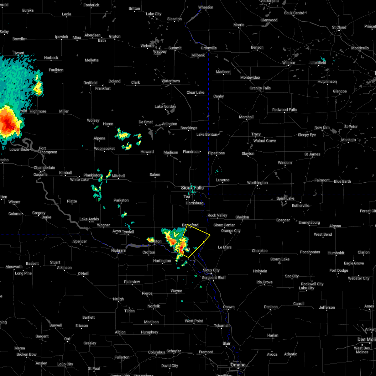 At 245 am cdt, a severe thunderstorm was located over union grove state park, or 10 miles south of beresford, moving northeast at 50 mph (radar indicated). Hazards include 60 mph wind gusts. Expect damage to roofs, siding, and trees. locations impacted include, beresford, alcester and hawarden. hail threat, radar indicated max hail size, <. 75 in wind threat, radar indicated max wind gust, 60 mph. At 245 am cdt, a severe thunderstorm was located over union grove state park, or 10 miles south of beresford, moving northeast at 50 mph (radar indicated). Hazards include 60 mph wind gusts. Expect damage to roofs, siding, and trees. locations impacted include, beresford, alcester and hawarden. hail threat, radar indicated max hail size, <. 75 in wind threat, radar indicated max wind gust, 60 mph.
|
| 6/14/2022 2:29 AM CDT |
 At 229 am cdt, a severe thunderstorm was located over vermillion, moving northeast at 50 mph (radar indicated). Hazards include 60 mph wind gusts. Expect damage to roofs, siding, and trees. this severe thunderstorm will be near, union grove state park around 245 am cdt. other locations in the path of this severe thunderstorm include beresford, hawarden and alcester. hail threat, radar indicated max hail size, <. 75 in wind threat, radar indicated max wind gust, 60 mph. At 229 am cdt, a severe thunderstorm was located over vermillion, moving northeast at 50 mph (radar indicated). Hazards include 60 mph wind gusts. Expect damage to roofs, siding, and trees. this severe thunderstorm will be near, union grove state park around 245 am cdt. other locations in the path of this severe thunderstorm include beresford, hawarden and alcester. hail threat, radar indicated max hail size, <. 75 in wind threat, radar indicated max wind gust, 60 mph.
|
| 5/30/2022 1:49 AM CDT |
 At 148 am cdt, severe thunderstorms were located along a line extending from near centerville to near union grove state park to near vermillion, moving northeast at 65 mph (radar indicated). Hazards include 60 mph wind gusts. Expect damage to roofs, siding, and trees. these severe storms will be near, beresford around 155 am cdt. alcester around 200 am cdt. worthing around 205 am cdt. hawarden, hudson and newton hills state park around 210 am cdt. canton around 215 am cdt. hail threat, radar indicated max hail size, <. 75 in wind threat, radar indicated max wind gust, 60 mph. At 148 am cdt, severe thunderstorms were located along a line extending from near centerville to near union grove state park to near vermillion, moving northeast at 65 mph (radar indicated). Hazards include 60 mph wind gusts. Expect damage to roofs, siding, and trees. these severe storms will be near, beresford around 155 am cdt. alcester around 200 am cdt. worthing around 205 am cdt. hawarden, hudson and newton hills state park around 210 am cdt. canton around 215 am cdt. hail threat, radar indicated max hail size, <. 75 in wind threat, radar indicated max wind gust, 60 mph.
|
| 5/30/2022 1:37 AM CDT |
 At 136 am cdt, severe thunderstorms were located along a line extending from volin to near meckling to near maskell, moving northeast at 65 mph (radar indicated). Hazards include 60 mph wind gusts. Expect damage to roofs, siding, and trees. severe thunderstorms will be near, wakonda around 140 am cdt. centerville, viborg and union grove state park around 150 am cdt. beresford, alcester and davis around 155 am cdt. canton, hawarden, lennox, worthing, hudson and newton hills state park around 200 am cdt. hail threat, radar indicated max hail size, <. 75 in wind threat, radar indicated max wind gust, 60 mph. At 136 am cdt, severe thunderstorms were located along a line extending from volin to near meckling to near maskell, moving northeast at 65 mph (radar indicated). Hazards include 60 mph wind gusts. Expect damage to roofs, siding, and trees. severe thunderstorms will be near, wakonda around 140 am cdt. centerville, viborg and union grove state park around 150 am cdt. beresford, alcester and davis around 155 am cdt. canton, hawarden, lennox, worthing, hudson and newton hills state park around 200 am cdt. hail threat, radar indicated max hail size, <. 75 in wind threat, radar indicated max wind gust, 60 mph.
|
| 5/12/2022 7:29 PM CDT |
 At 727 pm cdt, severe thunderstorms were located along a line extending from 6 miles west of akron to near anthon, moving northeast at 60 mph (radar indicated. at 7:09 pm cdt, a 68 mph wind gust was reported at sioux gateway airport). Hazards include golf ball size hail and 70 mph wind gusts. People and animals outdoors will be injured. expect hail damage to roofs, siding, windows, and vehicles. expect considerable tree damage. wind damage is also likely to mobile homes, roofs, and outbuildings. locations impacted include, anthon, kingsley, correctionville, alcester, pierson, hawarden, washta, craig and ireton. thunderstorm damage threat, considerable hail threat, radar indicated max hail size, 1. 75 in wind threat, radar indicated max wind gust, 70 mph. At 727 pm cdt, severe thunderstorms were located along a line extending from 6 miles west of akron to near anthon, moving northeast at 60 mph (radar indicated. at 7:09 pm cdt, a 68 mph wind gust was reported at sioux gateway airport). Hazards include golf ball size hail and 70 mph wind gusts. People and animals outdoors will be injured. expect hail damage to roofs, siding, windows, and vehicles. expect considerable tree damage. wind damage is also likely to mobile homes, roofs, and outbuildings. locations impacted include, anthon, kingsley, correctionville, alcester, pierson, hawarden, washta, craig and ireton. thunderstorm damage threat, considerable hail threat, radar indicated max hail size, 1. 75 in wind threat, radar indicated max wind gust, 70 mph.
|
| 5/12/2022 7:25 PM CDT | Quarter sized hail reported 0.6 miles NW of Vermillion, SD, report from mping: quarter (1.00 in.). |
| 5/12/2022 7:20 PM CDT | Quarter sized hail reported 0.6 miles NW of Vermillion, SD, report from mping: quarter (1.00 in.). |
| 5/12/2022 7:17 PM CDT |
 At 717 pm cdt, severe thunderstorms were located along a line extending from near mayfield to near vermillion, moving northeast at 55 mph (radar indicated). Hazards include 70 mph wind gusts and ping pong ball size hail. People and animals outdoors will be injured. expect hail damage to roofs, siding, windows, and vehicles. expect considerable tree damage. wind damage is also likely to mobile homes, roofs, and outbuildings. severe thunderstorms will be near, centerville, viborg and union grove state park around 730 pm cdt. hurley and davis around 735 pm cdt. other locations in the path of these severe thunderstorms include beresford, alcester, hawarden, lennox, chancellor, worthing, tea, hudson, fairview, newton hills state park, sioux falls, canton, harrisburg, rock valley, inwood and lake alvin state recreation area. thunderstorm damage threat, considerable hail threat, radar indicated max hail size, 1. 50 in wind threat, radar indicated max wind gust, 70 mph. At 717 pm cdt, severe thunderstorms were located along a line extending from near mayfield to near vermillion, moving northeast at 55 mph (radar indicated). Hazards include 70 mph wind gusts and ping pong ball size hail. People and animals outdoors will be injured. expect hail damage to roofs, siding, windows, and vehicles. expect considerable tree damage. wind damage is also likely to mobile homes, roofs, and outbuildings. severe thunderstorms will be near, centerville, viborg and union grove state park around 730 pm cdt. hurley and davis around 735 pm cdt. other locations in the path of these severe thunderstorms include beresford, alcester, hawarden, lennox, chancellor, worthing, tea, hudson, fairview, newton hills state park, sioux falls, canton, harrisburg, rock valley, inwood and lake alvin state recreation area. thunderstorm damage threat, considerable hail threat, radar indicated max hail size, 1. 50 in wind threat, radar indicated max wind gust, 70 mph.
|
| 5/12/2022 7:07 PM CDT |
 At 707 pm cdt, severe thunderstorms were located along a line extending from near newcastle to near sloan, moving northeast at 60 mph (radar indicated). Hazards include golf ball size hail and 70 mph wind gusts. People and animals outdoors will be injured. expect hail damage to roofs, siding, windows, and vehicles. expect considerable tree damage. wind damage is also likely to mobile homes, roofs, and outbuildings. these severe storms will be near, sloan and salix around 710 pm cdt. ponca, hornick and ponca state park around 715 pm cdt. vermillion, elk point and jefferson around 720 pm cdt. other locations in the path of these severe thunderstorms include lawton, moville, anthon, akron, kingsley, correctionville, alcester, pierson, hawarden, ireton, washta and craig. thunderstorm damage threat, considerable hail threat, radar indicated max hail size, 1. 75 in wind threat, radar indicated max wind gust, 70 mph. At 707 pm cdt, severe thunderstorms were located along a line extending from near newcastle to near sloan, moving northeast at 60 mph (radar indicated). Hazards include golf ball size hail and 70 mph wind gusts. People and animals outdoors will be injured. expect hail damage to roofs, siding, windows, and vehicles. expect considerable tree damage. wind damage is also likely to mobile homes, roofs, and outbuildings. these severe storms will be near, sloan and salix around 710 pm cdt. ponca, hornick and ponca state park around 715 pm cdt. vermillion, elk point and jefferson around 720 pm cdt. other locations in the path of these severe thunderstorms include lawton, moville, anthon, akron, kingsley, correctionville, alcester, pierson, hawarden, ireton, washta and craig. thunderstorm damage threat, considerable hail threat, radar indicated max hail size, 1. 75 in wind threat, radar indicated max wind gust, 70 mph.
|
| 5/12/2022 7:02 PM CDT |
 At 702 pm cdt, severe thunderstorms were located along a line extending from 8 miles west of martinsburg to near whiting, moving northeast at 60 mph (radar indicated). Hazards include 70 mph wind gusts and half dollar size hail. Hail damage to vehicles is expected. expect considerable tree damage. wind damage is also likely to mobile homes, roofs, and outbuildings. severe thunderstorms will be near, sloan and salix around 710 pm cdt. hornick and ponca state park around 715 pm cdt. vermillion, elk point and jefferson around 720 pm cdt. other locations in the path of these severe thunderstorms include lawton, moville, anthon, akron, kingsley, correctionville, pierson, alcester, hawarden, ireton, washta, craig and struble. thunderstorm damage threat, considerable hail threat, radar indicated max hail size, 1. 25 in wind threat, radar indicated max wind gust, 70 mph. At 702 pm cdt, severe thunderstorms were located along a line extending from 8 miles west of martinsburg to near whiting, moving northeast at 60 mph (radar indicated). Hazards include 70 mph wind gusts and half dollar size hail. Hail damage to vehicles is expected. expect considerable tree damage. wind damage is also likely to mobile homes, roofs, and outbuildings. severe thunderstorms will be near, sloan and salix around 710 pm cdt. hornick and ponca state park around 715 pm cdt. vermillion, elk point and jefferson around 720 pm cdt. other locations in the path of these severe thunderstorms include lawton, moville, anthon, akron, kingsley, correctionville, pierson, alcester, hawarden, ireton, washta, craig and struble. thunderstorm damage threat, considerable hail threat, radar indicated max hail size, 1. 25 in wind threat, radar indicated max wind gust, 70 mph.
|
| 5/12/2022 4:55 PM CDT | Report from mping: 1-inch tree limbs broken; shingles blown of in clay county SD, 0.6 miles NW of Vermillion, SD |
| 5/12/2022 4:30 PM CDT | Report from mping: 3-inch tree limbs broken; power poles broke in clay county SD, 1.5 miles WNW of Vermillion, SD |
| 5/12/2022 4:28 PM CDT | Semi blown ove in clay county SD, 5.7 miles ESE of Vermillion, SD |
| 5/12/2022 4:20 PM CDT |
 At 420 pm cdt, severe thunderstorms were located along a line extending from 8 miles south of yankton to 6 miles west of dixon in dixon county to 7 miles south of stanton, moving east at 70 mph (radar indicated). Hazards include 70 mph wind gusts and half dollar size hail. Hail damage to vehicles is expected. expect considerable tree damage. wind damage is also likely to mobile homes, roofs, and outbuildings. severe thunderstorms will be near, concord and dixon in dixon county around 425 pm cdt. wakefield around 430 pm cdt. emerson, allen, newcastle, meckling, martinsburg and maskell around 435 pm cdt. vermillion and ponca around 440 pm cdt. elk point, homer, hubbard, jackson in dakota county and ponca state park around 445 pm cdt. north sioux city, dakota city, jefferson and union grove state park around 450 pm cdt. sioux city, beresford, south sioux city and sergeant bluff around 455 pm cdt. akron, sloan, hinton, lawton, alcester and merrill around 500 pm cdt. Other locations impacted by these severe thunderstorms include bronson, chatsworth, waterbury and westfield. At 420 pm cdt, severe thunderstorms were located along a line extending from 8 miles south of yankton to 6 miles west of dixon in dixon county to 7 miles south of stanton, moving east at 70 mph (radar indicated). Hazards include 70 mph wind gusts and half dollar size hail. Hail damage to vehicles is expected. expect considerable tree damage. wind damage is also likely to mobile homes, roofs, and outbuildings. severe thunderstorms will be near, concord and dixon in dixon county around 425 pm cdt. wakefield around 430 pm cdt. emerson, allen, newcastle, meckling, martinsburg and maskell around 435 pm cdt. vermillion and ponca around 440 pm cdt. elk point, homer, hubbard, jackson in dakota county and ponca state park around 445 pm cdt. north sioux city, dakota city, jefferson and union grove state park around 450 pm cdt. sioux city, beresford, south sioux city and sergeant bluff around 455 pm cdt. akron, sloan, hinton, lawton, alcester and merrill around 500 pm cdt. Other locations impacted by these severe thunderstorms include bronson, chatsworth, waterbury and westfield.
|
| 9/17/2021 12:38 AM CDT | Personal weather station (ksdburba2 in clay county SD, 6.1 miles W of Vermillion, SD |
| 9/17/2021 12:29 AM CDT |
 At 1228 am cdt, severe thunderstorms were located along a line extending from near centerville to 6 miles west of union grove state park to near hartington, moving east at 55 mph (radar indicated). Hazards include 60 mph wind gusts. Expect damage to roofs, siding, and trees. severe thunderstorms will be near, beresford and union grove state park around 1235 am cdt. alcester, maskell and newton hills state park around 1245 am cdt. vermillion, akron, hudson and fairview around 1250 am cdt. hawarden and newcastle around 1255 am cdt. rock valley, ireton, craig and ponca state park around 100 am cdt. sioux center and elk point around 105 am cdt. hull, jefferson, maurice and struble around 110 am cdt. orange city, alton and boyden around 115 am cdt. other locations impacted by these severe thunderstorms include gayville, chatsworth, brunsville and westfield. hail threat, radar indicated max hail size, <. 75 in wind threat, radar indicated max wind gust, 60 mph. At 1228 am cdt, severe thunderstorms were located along a line extending from near centerville to 6 miles west of union grove state park to near hartington, moving east at 55 mph (radar indicated). Hazards include 60 mph wind gusts. Expect damage to roofs, siding, and trees. severe thunderstorms will be near, beresford and union grove state park around 1235 am cdt. alcester, maskell and newton hills state park around 1245 am cdt. vermillion, akron, hudson and fairview around 1250 am cdt. hawarden and newcastle around 1255 am cdt. rock valley, ireton, craig and ponca state park around 100 am cdt. sioux center and elk point around 105 am cdt. hull, jefferson, maurice and struble around 110 am cdt. orange city, alton and boyden around 115 am cdt. other locations impacted by these severe thunderstorms include gayville, chatsworth, brunsville and westfield. hail threat, radar indicated max hail size, <. 75 in wind threat, radar indicated max wind gust, 60 mph.
|
| 7/8/2021 11:28 PM CDT |
 At 1128 pm cdt, severe thunderstorms were located along a line extending from near meckling to near maskell to 8 miles northeast of coleridge, moving southeast at 35 mph (radar indicated). Hazards include 60 mph wind gusts and quarter size hail. Hail damage to vehicles is expected. expect wind damage to roofs, siding, and trees. these severe storms will be near, newcastle around 1140 pm cdt. martinsburg around 1150 pm cdt. Other locations impacted by these severe thunderstorms include gayville. At 1128 pm cdt, severe thunderstorms were located along a line extending from near meckling to near maskell to 8 miles northeast of coleridge, moving southeast at 35 mph (radar indicated). Hazards include 60 mph wind gusts and quarter size hail. Hail damage to vehicles is expected. expect wind damage to roofs, siding, and trees. these severe storms will be near, newcastle around 1140 pm cdt. martinsburg around 1150 pm cdt. Other locations impacted by these severe thunderstorms include gayville.
|
| 7/8/2021 11:11 PM CDT |
 At 1111 pm cdt, severe thunderstorms were located along a line extending from 6 miles west of meckling to near wynot to near hartington, moving southeast at 35 mph (radar indicated). Hazards include 60 mph wind gusts. Expect damage to roofs, siding, and trees. severe thunderstorms will be near, meckling around 1120 pm cdt. maskell around 1130 pm cdt. vermillion around 1135 pm cdt. newcastle around 1140 pm cdt. martinsburg around 1145 pm cdt. Other locations impacted by these severe thunderstorms include gayville. At 1111 pm cdt, severe thunderstorms were located along a line extending from 6 miles west of meckling to near wynot to near hartington, moving southeast at 35 mph (radar indicated). Hazards include 60 mph wind gusts. Expect damage to roofs, siding, and trees. severe thunderstorms will be near, meckling around 1120 pm cdt. maskell around 1130 pm cdt. vermillion around 1135 pm cdt. newcastle around 1140 pm cdt. martinsburg around 1145 pm cdt. Other locations impacted by these severe thunderstorms include gayville.
|
| 7/6/2021 1:24 PM CDT |
 At 124 pm cdt, a severe thunderstorm was located over meckling, or 10 miles northwest of vermillion, moving east at 35 mph (radar indicated). Hazards include 60 mph wind gusts and penny size hail. Expect damage to roofs, siding, and trees. this severe storm will be near, vermillion around 135 pm cdt. Other locations impacted by this severe thunderstorm include gayville. At 124 pm cdt, a severe thunderstorm was located over meckling, or 10 miles northwest of vermillion, moving east at 35 mph (radar indicated). Hazards include 60 mph wind gusts and penny size hail. Expect damage to roofs, siding, and trees. this severe storm will be near, vermillion around 135 pm cdt. Other locations impacted by this severe thunderstorm include gayville.
|
| 7/6/2021 1:05 PM CDT |
 At 104 pm cdt, a severe thunderstorm was located near wynot, or 9 miles southeast of yankton, moving east at 40 mph (radar indicated). Hazards include 60 mph wind gusts and penny size hail. Expect damage to roofs, siding, and trees. this severe thunderstorm will be near, meckling around 115 pm cdt. vermillion around 125 pm cdt. other locations impacted by this severe thunderstorm include gayville and st. Helena boat dock. At 104 pm cdt, a severe thunderstorm was located near wynot, or 9 miles southeast of yankton, moving east at 40 mph (radar indicated). Hazards include 60 mph wind gusts and penny size hail. Expect damage to roofs, siding, and trees. this severe thunderstorm will be near, meckling around 115 pm cdt. vermillion around 125 pm cdt. other locations impacted by this severe thunderstorm include gayville and st. Helena boat dock.
|
| 6/11/2021 6:27 AM CDT |
 At 625 am cdt, severe thunderstorms were located along a line extending from near beresford to near newcastle to near coleridge, moving southeast at 45 mph (radar indicated). Hazards include 60 mph wind gusts. Expect damage to roofs, siding, and trees. these severe storms will be near, newcastle and union grove state park around 630 am cdt. alcester and dixon in dixon county around 635 am cdt. ponca, elk point, concord and ponca state park around 640 am cdt. allen around 645 am cdt. Other locations impacted by these severe thunderstorms include waterbury. At 625 am cdt, severe thunderstorms were located along a line extending from near beresford to near newcastle to near coleridge, moving southeast at 45 mph (radar indicated). Hazards include 60 mph wind gusts. Expect damage to roofs, siding, and trees. these severe storms will be near, newcastle and union grove state park around 630 am cdt. alcester and dixon in dixon county around 635 am cdt. ponca, elk point, concord and ponca state park around 640 am cdt. allen around 645 am cdt. Other locations impacted by these severe thunderstorms include waterbury.
|
| 6/11/2021 5:56 AM CDT |
 At 556 am cdt, severe thunderstorms were located along a line extending from near irene to 6 miles south of mission hill to near wausa, moving southeast at 45 mph (radar indicated). Hazards include 60 mph wind gusts. Expect damage to roofs, siding, and trees. severe thunderstorms will be near, wakonda around 605 am cdt. meckling around 610 am cdt. vermillion and maskell around 620 am cdt. beresford and newcastle around 625 am cdt. union grove state park around 630 am cdt. elk point, alcester, concord and dixon in dixon county around 635 am cdt. ponca and ponca state park around 640 am cdt. wakefield, jefferson and allen around 645 am cdt. Other locations impacted by these severe thunderstorms include waterbury. At 556 am cdt, severe thunderstorms were located along a line extending from near irene to 6 miles south of mission hill to near wausa, moving southeast at 45 mph (radar indicated). Hazards include 60 mph wind gusts. Expect damage to roofs, siding, and trees. severe thunderstorms will be near, wakonda around 605 am cdt. meckling around 610 am cdt. vermillion and maskell around 620 am cdt. beresford and newcastle around 625 am cdt. union grove state park around 630 am cdt. elk point, alcester, concord and dixon in dixon county around 635 am cdt. ponca and ponca state park around 640 am cdt. wakefield, jefferson and allen around 645 am cdt. Other locations impacted by these severe thunderstorms include waterbury.
|
| 7/28/2020 8:06 PM CDT | Report via social media. large tree limbs down on east side of tow in clay county SD, 3 miles W of Vermillion, SD |
| 7/28/2020 8:02 PM CDT |
 At 801 pm cdt, a severe thunderstorm was located near elk point, or 10 miles east of vermillion, moving east at 10 mph. a second severe thunderstorm was located 5 miles northwest of vermillion (radar indicated). Hazards include 60 mph wind gusts and quarter size hail. Hail damage to vehicles is expected. expect wind damage to roofs, siding, and trees. This severe thunderstorm will remain over mainly rural areas of southeastern clay and west central union counties. At 801 pm cdt, a severe thunderstorm was located near elk point, or 10 miles east of vermillion, moving east at 10 mph. a second severe thunderstorm was located 5 miles northwest of vermillion (radar indicated). Hazards include 60 mph wind gusts and quarter size hail. Hail damage to vehicles is expected. expect wind damage to roofs, siding, and trees. This severe thunderstorm will remain over mainly rural areas of southeastern clay and west central union counties.
|
| 7/28/2020 7:38 PM CDT |
 At 737 pm cdt, a severe thunderstorm was located near vermillion, moving east at 10 mph (radar indicated). Hazards include 60 mph wind gusts and quarter size hail. Hail damage to vehicles is expected. expect wind damage to roofs, siding, and trees. This severe thunderstorm will be near, elk point around 815 pm cdt. At 737 pm cdt, a severe thunderstorm was located near vermillion, moving east at 10 mph (radar indicated). Hazards include 60 mph wind gusts and quarter size hail. Hail damage to vehicles is expected. expect wind damage to roofs, siding, and trees. This severe thunderstorm will be near, elk point around 815 pm cdt.
|
| 7/6/2020 5:34 PM CDT | Half Dollar sized hail reported 9.3 miles E of Vermillion, SD, strong winds accompanied the hail... but no estimates on strength and no visible damage. |
| 7/3/2020 5:20 PM CDT |
 At 518 pm cdt, a severe thunderstorm was located 7 miles east of vermillion, moving south at 35 mph (ground observation station. at 5:09 pm, a wind gust measured at 74 mph was reported southwest of junction city). Hazards include 70 mph wind gusts and quarter size hail. Hail damage to vehicles is expected. expect considerable tree damage. wind damage is also likely to mobile homes, roofs, and outbuildings. This severe storm will be near, elk point around 530 pm cdt. At 518 pm cdt, a severe thunderstorm was located 7 miles east of vermillion, moving south at 35 mph (ground observation station. at 5:09 pm, a wind gust measured at 74 mph was reported southwest of junction city). Hazards include 70 mph wind gusts and quarter size hail. Hail damage to vehicles is expected. expect considerable tree damage. wind damage is also likely to mobile homes, roofs, and outbuildings. This severe storm will be near, elk point around 530 pm cdt.
|
| 7/3/2020 5:09 PM CDT | Storm damage reported in clay county SD, 6.1 miles W of Vermillion, SD |
| 7/3/2020 5:00 PM CDT |
 At 459 pm cdt, a severe thunderstorm was located over union grove state park, or 10 miles south of beresford, moving south at 35 mph (radar indicated. at 4:45 pm, a wind gust to 60 mph was reported 8 miles south of beresford). Hazards include 60 mph wind gusts and quarter size hail. Hail damage to vehicles is expected. expect wind damage to roofs, siding, and trees. this severe thunderstorm will be near, vermillion around 515 pm cdt. Elk point around 530 pm cdt. At 459 pm cdt, a severe thunderstorm was located over union grove state park, or 10 miles south of beresford, moving south at 35 mph (radar indicated. at 4:45 pm, a wind gust to 60 mph was reported 8 miles south of beresford). Hazards include 60 mph wind gusts and quarter size hail. Hail damage to vehicles is expected. expect wind damage to roofs, siding, and trees. this severe thunderstorm will be near, vermillion around 515 pm cdt. Elk point around 530 pm cdt.
|
| 6/21/2020 3:05 PM CDT | Quarter sized hail reported 6.2 miles SW of Vermillion, SD |
| 6/21/2020 2:55 PM CDT |
 At 255 pm cdt, a severe thunderstorm was located near vermillion, moving east at 30 mph (public). Hazards include 60 mph wind gusts and quarter size hail. Hail damage to vehicles is expected. expect wind damage to roofs, siding, and trees. Locations impacted include, vermillion. At 255 pm cdt, a severe thunderstorm was located near vermillion, moving east at 30 mph (public). Hazards include 60 mph wind gusts and quarter size hail. Hail damage to vehicles is expected. expect wind damage to roofs, siding, and trees. Locations impacted include, vermillion.
|
| 6/21/2020 2:42 PM CDT |
 At 241 pm cdt, a severe thunderstorm was located over vermillion, moving northeast at 25 mph (public. at 240 pm cdt quarter size hail was reported in vermillion). Hazards include 60 mph wind gusts and quarter size hail. Hail damage to vehicles is expected. expect wind damage to roofs, siding, and trees. This severe thunderstorm will remain over mainly rural areas of northwestern dixon, southern clay and west central union counties. At 241 pm cdt, a severe thunderstorm was located over vermillion, moving northeast at 25 mph (public. at 240 pm cdt quarter size hail was reported in vermillion). Hazards include 60 mph wind gusts and quarter size hail. Hail damage to vehicles is expected. expect wind damage to roofs, siding, and trees. This severe thunderstorm will remain over mainly rural areas of northwestern dixon, southern clay and west central union counties.
|
| 6/21/2020 2:40 PM CDT | Quarter sized hail reported 0.4 miles N of Vermillion, SD, hail up to quarter sized in diameter reported in vermillion. |
| 6/21/2020 2:29 PM CDT |
 At 229 pm cdt, a severe thunderstorm was located over maskell, or near vermillion, moving east at 20 mph (radar indicated). Hazards include 60 mph wind gusts and quarter size hail. Hail damage to vehicles is expected. expect wind damage to roofs, siding, and trees. This severe thunderstorm will be near, vermillion around 240 pm cdt. At 229 pm cdt, a severe thunderstorm was located over maskell, or near vermillion, moving east at 20 mph (radar indicated). Hazards include 60 mph wind gusts and quarter size hail. Hail damage to vehicles is expected. expect wind damage to roofs, siding, and trees. This severe thunderstorm will be near, vermillion around 240 pm cdt.
|
| 5/24/2020 4:10 AM CDT |
 The severe thunderstorm warning for dixon and clay counties will expire at 415 am cdt, the severe thunderstorm which prompted the warning has moved out of the warned area. therefore, the warning will be allowed to expire. a severe thunderstorm watch remains in effect until 600 am cdt for northeastern nebraska, and southeastern south dakota. The severe thunderstorm warning for dixon and clay counties will expire at 415 am cdt, the severe thunderstorm which prompted the warning has moved out of the warned area. therefore, the warning will be allowed to expire. a severe thunderstorm watch remains in effect until 600 am cdt for northeastern nebraska, and southeastern south dakota.
|
| 5/24/2020 3:58 AM CDT |
 At 357 am cdt, a severe thunderstorm was located near vermillion, moving northeast at 40 mph (radar indicated). Hazards include 70 mph wind gusts. Expect considerable tree damage. damage is likely to mobile homes, roofs, and outbuildings. This severe thunderstorm will remain over mainly rural areas of dixon and clay counties. At 357 am cdt, a severe thunderstorm was located near vermillion, moving northeast at 40 mph (radar indicated). Hazards include 70 mph wind gusts. Expect considerable tree damage. damage is likely to mobile homes, roofs, and outbuildings. This severe thunderstorm will remain over mainly rural areas of dixon and clay counties.
|
| 5/24/2020 3:55 AM CDT | Storm damage reported in clay county SD, 6.1 miles W of Vermillion, SD |
| 5/24/2020 3:25 AM CDT |
 At 323 am cdt, a severe thunderstorm was located over hartington, or 19 miles southwest of vermillion, moving northeast at 40 mph (radar indicated. this storm has a history of producing wind gusts around 75 mph). Hazards include 70 mph wind gusts. Expect considerable tree damage. damage is likely to mobile homes, roofs, and outbuildings. this severe thunderstorm will be near, maskell around 345 am cdt. meckling around 350 am cdt. vermillion around 355 am cdt. Other locations impacted by this severe thunderstorm include gayville. At 323 am cdt, a severe thunderstorm was located over hartington, or 19 miles southwest of vermillion, moving northeast at 40 mph (radar indicated. this storm has a history of producing wind gusts around 75 mph). Hazards include 70 mph wind gusts. Expect considerable tree damage. damage is likely to mobile homes, roofs, and outbuildings. this severe thunderstorm will be near, maskell around 345 am cdt. meckling around 350 am cdt. vermillion around 355 am cdt. Other locations impacted by this severe thunderstorm include gayville.
|
| 7/17/2019 7:01 AM CDT |
 At 700 am cdt, severe thunderstorms were located along a line extending from harrisburg to near union grove state park, moving east at 40 mph (trained weather spotters). Hazards include 70 mph wind gusts and quarter size hail. Hail damage to vehicles is expected. expect considerable tree damage. wind damage is also likely to mobile homes, roofs, and outbuildings. these severe storms will be near, lake alvin state recreation area around 705 am cdt. Other locations impacted by these severe thunderstorms include gayville. At 700 am cdt, severe thunderstorms were located along a line extending from harrisburg to near union grove state park, moving east at 40 mph (trained weather spotters). Hazards include 70 mph wind gusts and quarter size hail. Hail damage to vehicles is expected. expect considerable tree damage. wind damage is also likely to mobile homes, roofs, and outbuildings. these severe storms will be near, lake alvin state recreation area around 705 am cdt. Other locations impacted by these severe thunderstorms include gayville.
|
| 7/17/2019 6:17 AM CDT |
 At 616 am cdt, severe thunderstorms were located along a line extending from monroe to yankton, moving east at 40 mph. these are very dangerous storms (trained weather spotters). Hazards include 80 mph wind gusts and quarter size hail. Flying debris will be dangerous to those caught without shelter. mobile homes will be heavily damaged. expect considerable damage to roofs, windows, and vehicles. extensive tree damage and power outages are likely. severe thunderstorms will be near, parker around 625 am cdt. volin around 630 am cdt. chancellor around 635 am cdt. meckling around 640 am cdt. tea around 645 am cdt. vermillion around 650 am cdt. harrisburg around 655 am cdt. union grove state park around 700 am cdt. other locations impacted by these severe thunderstorms include gayville and st. Helena boat dock. At 616 am cdt, severe thunderstorms were located along a line extending from monroe to yankton, moving east at 40 mph. these are very dangerous storms (trained weather spotters). Hazards include 80 mph wind gusts and quarter size hail. Flying debris will be dangerous to those caught without shelter. mobile homes will be heavily damaged. expect considerable damage to roofs, windows, and vehicles. extensive tree damage and power outages are likely. severe thunderstorms will be near, parker around 625 am cdt. volin around 630 am cdt. chancellor around 635 am cdt. meckling around 640 am cdt. tea around 645 am cdt. vermillion around 650 am cdt. harrisburg around 655 am cdt. union grove state park around 700 am cdt. other locations impacted by these severe thunderstorms include gayville and st. Helena boat dock.
|
| 8/5/2018 2:53 AM CDT |
 The severe thunderstorm warning for northwestern dixon, clay, southwestern lincoln, yankton, southern turner and southeastern hutchinson counties will expire at 300 am cdt, the storms which prompted the warning have moved out of the area. therefore, the warning will be allowed to expire. however gusty winds and heavy rain are still possible with these thunderstorms. a severe thunderstorm watch remains in effect until 700 am cdt for northeastern nebraska, and southeastern south dakota. The severe thunderstorm warning for northwestern dixon, clay, southwestern lincoln, yankton, southern turner and southeastern hutchinson counties will expire at 300 am cdt, the storms which prompted the warning have moved out of the area. therefore, the warning will be allowed to expire. however gusty winds and heavy rain are still possible with these thunderstorms. a severe thunderstorm watch remains in effect until 700 am cdt for northeastern nebraska, and southeastern south dakota.
|
| 8/5/2018 2:37 AM CDT |
 At 212 am cdt, severe thunderstorms were located along a line extending from near viborg to 8 miles northwest of mayfield to near tripp, moving south at 40 mph (radar indicated). Hazards include 70 mph wind gusts and penny size hail. Expect considerable tree damage. damage is likely to mobile homes, roofs, and outbuildings. severe thunderstorms will be near, viborg around 215 am cdt. centerville, irene and mayfield around 225 am cdt. wakonda and utica around 235 am cdt. yankton, mission hill and volin around 240 am cdt. tyndall and lewis and clark state recreation area around 245 am cdt. meckling around 255 am cdt. vermillion and maskell around 300 am cdt. Other locations impacted by these severe thunderstorms include gayville, lesterville and olivet. At 212 am cdt, severe thunderstorms were located along a line extending from near viborg to 8 miles northwest of mayfield to near tripp, moving south at 40 mph (radar indicated). Hazards include 70 mph wind gusts and penny size hail. Expect considerable tree damage. damage is likely to mobile homes, roofs, and outbuildings. severe thunderstorms will be near, viborg around 215 am cdt. centerville, irene and mayfield around 225 am cdt. wakonda and utica around 235 am cdt. yankton, mission hill and volin around 240 am cdt. tyndall and lewis and clark state recreation area around 245 am cdt. meckling around 255 am cdt. vermillion and maskell around 300 am cdt. Other locations impacted by these severe thunderstorms include gayville, lesterville and olivet.
|
| 8/5/2018 2:37 AM CDT |
 At 237 am cdt, severe thunderstorms were located along a line extending from near wakonda to near utica to near avon, moving east at 40 mph (radar indicated). Hazards include 70 mph wind gusts and penny size hail. Expect considerable tree damage. damage is likely to mobile homes, roofs, and outbuildings. these severe storms will be near, yankton around 240 am cdt. mayfield and mission hill around 245 am cdt. volin around 255 am cdt. wakonda around 300 am cdt. Other locations impacted by these severe thunderstorms include gayville and lesterville. At 237 am cdt, severe thunderstorms were located along a line extending from near wakonda to near utica to near avon, moving east at 40 mph (radar indicated). Hazards include 70 mph wind gusts and penny size hail. Expect considerable tree damage. damage is likely to mobile homes, roofs, and outbuildings. these severe storms will be near, yankton around 240 am cdt. mayfield and mission hill around 245 am cdt. volin around 255 am cdt. wakonda around 300 am cdt. Other locations impacted by these severe thunderstorms include gayville and lesterville.
|
| 8/5/2018 2:12 AM CDT |
 At 212 am cdt, severe thunderstorms were located along a line extending from near viborg to 8 miles northwest of mayfield to near tripp, moving south at 40 mph (radar indicated). Hazards include 70 mph wind gusts and penny size hail. Expect considerable tree damage. damage is likely to mobile homes, roofs, and outbuildings. severe thunderstorms will be near, viborg around 215 am cdt. centerville, irene and mayfield around 225 am cdt. wakonda and utica around 235 am cdt. yankton, mission hill and volin around 240 am cdt. tyndall and lewis and clark state recreation area around 245 am cdt. meckling around 255 am cdt. vermillion and maskell around 300 am cdt. Other locations impacted by these severe thunderstorms include gayville, lesterville and olivet. At 212 am cdt, severe thunderstorms were located along a line extending from near viborg to 8 miles northwest of mayfield to near tripp, moving south at 40 mph (radar indicated). Hazards include 70 mph wind gusts and penny size hail. Expect considerable tree damage. damage is likely to mobile homes, roofs, and outbuildings. severe thunderstorms will be near, viborg around 215 am cdt. centerville, irene and mayfield around 225 am cdt. wakonda and utica around 235 am cdt. yankton, mission hill and volin around 240 am cdt. tyndall and lewis and clark state recreation area around 245 am cdt. meckling around 255 am cdt. vermillion and maskell around 300 am cdt. Other locations impacted by these severe thunderstorms include gayville, lesterville and olivet.
|
| 10/6/2017 7:04 AM CDT |
 At 704 am cdt, a severe thunderstorm was located over maskell, or 8 miles south of vermillion, moving northeast at 30 mph (radar indicated). Hazards include quarter size hail. Damage to vehicles is expected. This severe storm will be near, vermillion around 715 am cdt. At 704 am cdt, a severe thunderstorm was located over maskell, or 8 miles south of vermillion, moving northeast at 30 mph (radar indicated). Hazards include quarter size hail. Damage to vehicles is expected. This severe storm will be near, vermillion around 715 am cdt.
|
| 10/6/2017 6:51 AM CDT |
 At 650 am cdt, a severe thunderstorm was located near maskell, or 13 miles south of vermillion, moving northeast at 30 mph (radar indicated). Hazards include quarter size hail. Damage to vehicles is expected. this severe thunderstorm will be near, maskell around 700 am cdt. newcastle around 705 am cdt. Vermillion around 715 am cdt. At 650 am cdt, a severe thunderstorm was located near maskell, or 13 miles south of vermillion, moving northeast at 30 mph (radar indicated). Hazards include quarter size hail. Damage to vehicles is expected. this severe thunderstorm will be near, maskell around 700 am cdt. newcastle around 705 am cdt. Vermillion around 715 am cdt.
|
| 8/21/2017 2:25 PM CDT |
 The severe thunderstorm warning for northern dixon, clay, southern lincoln, southeastern turner and union counties will expire at 230 pm cdt, the storms which prompted the warning have moved out of the warned area. therefore, the warning will be allowed to expire. however heavy rain is still possible with these thunderstorms. a severe thunderstorm watch remains in effect until 700 pm cdt for northwestern iowa, northeastern nebraska, and southeastern south dakota. The severe thunderstorm warning for northern dixon, clay, southern lincoln, southeastern turner and union counties will expire at 230 pm cdt, the storms which prompted the warning have moved out of the warned area. therefore, the warning will be allowed to expire. however heavy rain is still possible with these thunderstorms. a severe thunderstorm watch remains in effect until 700 pm cdt for northwestern iowa, northeastern nebraska, and southeastern south dakota.
|
| 8/21/2017 1:59 PM CDT |
 At 158 pm cdt, severe thunderstorms were located along a line extending from near canton to near akron to near maskell, moving east at 60 mph (radar indicated). Hazards include ping pong ball size hail and 60 mph wind gusts. People and animals outdoors will be injured. expect hail damage to roofs, siding, windows, and vehicles. expect wind damage to roofs, siding, and trees. these severe storms will be near, akron around 205 pm cdt. Elk point and ponca state park around 215 pm cdt. At 158 pm cdt, severe thunderstorms were located along a line extending from near canton to near akron to near maskell, moving east at 60 mph (radar indicated). Hazards include ping pong ball size hail and 60 mph wind gusts. People and animals outdoors will be injured. expect hail damage to roofs, siding, windows, and vehicles. expect wind damage to roofs, siding, and trees. these severe storms will be near, akron around 205 pm cdt. Elk point and ponca state park around 215 pm cdt.
|
| 8/21/2017 1:40 PM CDT |
 At 140 pm cdt, severe thunderstorms were located along a line extending from near chancellor to near wakonda to 7 miles southeast of yankton, moving east at 45 mph (radar indicated). Hazards include two inch hail and 60 mph wind gusts. People and animals outdoors will be injured. expect hail damage to roofs, siding, windows, and vehicles. expect wind damage to roofs, siding, and trees. severe thunderstorms will be near, centerville around 145 pm cdt. lennox around 150 pm cdt. beresford, worthing and meckling around 155 pm cdt. union grove state park around 200 pm cdt. vermillion and maskell around 205 pm cdt. canton, alcester, newcastle and newton hills state park around 210 pm cdt. hawarden and akron around 215 pm cdt. ponca, elk point and ponca state park around 225 pm cdt. Other locations impacted by these severe thunderstorms include gayville. At 140 pm cdt, severe thunderstorms were located along a line extending from near chancellor to near wakonda to 7 miles southeast of yankton, moving east at 45 mph (radar indicated). Hazards include two inch hail and 60 mph wind gusts. People and animals outdoors will be injured. expect hail damage to roofs, siding, windows, and vehicles. expect wind damage to roofs, siding, and trees. severe thunderstorms will be near, centerville around 145 pm cdt. lennox around 150 pm cdt. beresford, worthing and meckling around 155 pm cdt. union grove state park around 200 pm cdt. vermillion and maskell around 205 pm cdt. canton, alcester, newcastle and newton hills state park around 210 pm cdt. hawarden and akron around 215 pm cdt. ponca, elk point and ponca state park around 225 pm cdt. Other locations impacted by these severe thunderstorms include gayville.
|
| 6/29/2017 6:17 PM CDT | Golf Ball sized hail reported 3.1 miles E of Vermillion, SD |
| 6/29/2017 1:27 PM CDT |
 At 627 pm cdt, a severe thunderstorm was located 7 miles east of vermillion, moving east at 65 mph (radar indicated). Hazards include 70 mph wind gusts and ping pong ball size hail. People and animals outdoors will be injured. expect hail damage to roofs, siding, windows, and vehicles. expect considerable tree damage. wind damage is also likely to mobile homes, roofs, and outbuildings. this severe thunderstorm will be near, elk point around 630 pm cdt. akron around 640 pm cdt. Other locations impacted by this severe thunderstorm include westfield and chatsworth. At 627 pm cdt, a severe thunderstorm was located 7 miles east of vermillion, moving east at 65 mph (radar indicated). Hazards include 70 mph wind gusts and ping pong ball size hail. People and animals outdoors will be injured. expect hail damage to roofs, siding, windows, and vehicles. expect considerable tree damage. wind damage is also likely to mobile homes, roofs, and outbuildings. this severe thunderstorm will be near, elk point around 630 pm cdt. akron around 640 pm cdt. Other locations impacted by this severe thunderstorm include westfield and chatsworth.
|
| 6/29/2017 1:03 PM CDT |
 At 603 pm cdt, a severe thunderstorm was located near meckling, or 9 miles west of vermillion, moving east at 65 mph (radar indicated). Hazards include golf ball size hail and 70 mph wind gusts. People and animals outdoors will be injured. expect hail damage to roofs, siding, windows, and vehicles. expect considerable tree damage. wind damage is also likely to mobile homes, roofs, and outbuildings. this severe thunderstorm will be near, vermillion and maskell around 610 pm cdt. elk point around 625 pm cdt. Other locations impacted by this severe thunderstorm include gayville. At 603 pm cdt, a severe thunderstorm was located near meckling, or 9 miles west of vermillion, moving east at 65 mph (radar indicated). Hazards include golf ball size hail and 70 mph wind gusts. People and animals outdoors will be injured. expect hail damage to roofs, siding, windows, and vehicles. expect considerable tree damage. wind damage is also likely to mobile homes, roofs, and outbuildings. this severe thunderstorm will be near, vermillion and maskell around 610 pm cdt. elk point around 625 pm cdt. Other locations impacted by this severe thunderstorm include gayville.
|
| 6/13/2017 9:31 PM CDT |
 At 931 pm cdt, a severe thunderstorm was located over alcester, or 7 miles west of hawarden, moving northeast at 45 mph (radar indicated). Hazards include 70 mph wind gusts and nickel size hail. Expect considerable tree damage. damage is likely to mobile homes, roofs, and outbuildings. this severe storm will be near, hawarden around 940 pm cdt. hudson around 945 pm cdt. other locations impacted by this severe thunderstorm include chatsworth. A tornado watch remains in effect until 200 am cdt for northwestern iowa, northeastern nebraska, and southeastern south dakota. At 931 pm cdt, a severe thunderstorm was located over alcester, or 7 miles west of hawarden, moving northeast at 45 mph (radar indicated). Hazards include 70 mph wind gusts and nickel size hail. Expect considerable tree damage. damage is likely to mobile homes, roofs, and outbuildings. this severe storm will be near, hawarden around 940 pm cdt. hudson around 945 pm cdt. other locations impacted by this severe thunderstorm include chatsworth. A tornado watch remains in effect until 200 am cdt for northwestern iowa, northeastern nebraska, and southeastern south dakota.
|
| 6/13/2017 9:10 PM CDT |
 At 910 pm cdt, a severe thunderstorm was located near union grove state park, or 10 miles north of vermillion, moving northeast at 55 mph (radar indicated). Hazards include 60 mph wind gusts and nickel size hail. Expect damage to roofs, siding, and trees. this severe thunderstorm will be near, union grove state park around 915 pm cdt. beresford around 925 pm cdt. alcester around 930 pm cdt. hawarden around 935 pm cdt. hudson around 940 pm cdt. other locations impacted by this severe thunderstorm include chatsworth. A tornado watch remains in effect until 200 am cdt for northwestern iowa, northeastern nebraska, and southeastern south dakota. At 910 pm cdt, a severe thunderstorm was located near union grove state park, or 10 miles north of vermillion, moving northeast at 55 mph (radar indicated). Hazards include 60 mph wind gusts and nickel size hail. Expect damage to roofs, siding, and trees. this severe thunderstorm will be near, union grove state park around 915 pm cdt. beresford around 925 pm cdt. alcester around 930 pm cdt. hawarden around 935 pm cdt. hudson around 940 pm cdt. other locations impacted by this severe thunderstorm include chatsworth. A tornado watch remains in effect until 200 am cdt for northwestern iowa, northeastern nebraska, and southeastern south dakota.
|
| 6/7/2017 5:27 PM CDT | Quarter sized hail reported 6.2 miles SSW of Vermillion, SD |
| 6/7/2017 5:27 PM CDT |
 At 527 pm cdt, a severe thunderstorm was located near vermillion, moving east at 5 mph (radar indicated). Hazards include 60 mph wind gusts and quarter size hail. Hail damage to vehicles is expected. expect wind damage to roofs, siding, and trees. This severe thunderstorm will be near, union grove state park around 600 pm cdt. At 527 pm cdt, a severe thunderstorm was located near vermillion, moving east at 5 mph (radar indicated). Hazards include 60 mph wind gusts and quarter size hail. Hail damage to vehicles is expected. expect wind damage to roofs, siding, and trees. This severe thunderstorm will be near, union grove state park around 600 pm cdt.
|
| 4/15/2017 7:15 PM CDT |
 At 714 pm cdt, a severe thunderstorm was located 7 miles east of vermillion, moving east at 35 mph (trained weather spotters. at 705 pm cdt golf ball sized hail was reported in vermillion). Hazards include golf ball size hail. People and animals outdoors will be injured. expect damage to roofs, siding, windows, and vehicles. this severe storm will be near, akron around 735 pm cdt. Other locations impacted by this severe thunderstorm include westfield and chatsworth. At 714 pm cdt, a severe thunderstorm was located 7 miles east of vermillion, moving east at 35 mph (trained weather spotters. at 705 pm cdt golf ball sized hail was reported in vermillion). Hazards include golf ball size hail. People and animals outdoors will be injured. expect damage to roofs, siding, windows, and vehicles. this severe storm will be near, akron around 735 pm cdt. Other locations impacted by this severe thunderstorm include westfield and chatsworth.
|
| 4/15/2017 7:11 PM CDT |
 The severe thunderstorm warning for southwestern clay county will expire at 715 pm cdt, the storm which prompted the warning has moved out of the area. therefore the warning will be allowed to expire. remember, a severe thunderstorm warning still remains in effect for southeastern clay county until 745 pm cdt. The severe thunderstorm warning for southwestern clay county will expire at 715 pm cdt, the storm which prompted the warning has moved out of the area. therefore the warning will be allowed to expire. remember, a severe thunderstorm warning still remains in effect for southeastern clay county until 745 pm cdt.
|
| 4/15/2017 7:05 PM CDT | Golf Ball sized hail reported 0.4 miles N of Vermillion, SD, numerous reports of hail ranging from quarter to golf ball. |
| 4/15/2017 7:00 PM CDT |
 At 659 pm cdt, a severe thunderstorm was located near vermillion, moving east at 30 mph (trained weather spotters). Hazards include golf ball size hail. People and animals outdoors will be injured. expect damage to roofs, siding, windows, and vehicles. this severe thunderstorm will be near, akron around 740 pm cdt. Other locations impacted by this severe thunderstorm include westfield and chatsworth. At 659 pm cdt, a severe thunderstorm was located near vermillion, moving east at 30 mph (trained weather spotters). Hazards include golf ball size hail. People and animals outdoors will be injured. expect damage to roofs, siding, windows, and vehicles. this severe thunderstorm will be near, akron around 740 pm cdt. Other locations impacted by this severe thunderstorm include westfield and chatsworth.
|
| 4/15/2017 6:50 PM CDT | Half Dollar sized hail reported 8.1 miles ESE of Vermillion, SD |
| 4/15/2017 6:47 PM CDT |
 At 646 pm cdt, a severe thunderstorm was located over meckling, or 10 miles northwest of vermillion, moving east at 25 mph (trained weather spotters. at 633 pm cdt golf ball sized hail was reported 3 miles south of mission hill). Hazards include golf ball size hail. People and animals outdoors will be injured. expect damage to roofs, siding, windows, and vehicles. this severe storm will be near, meckling around 650 pm cdt. Vermillion around 710 pm cdt. At 646 pm cdt, a severe thunderstorm was located over meckling, or 10 miles northwest of vermillion, moving east at 25 mph (trained weather spotters. at 633 pm cdt golf ball sized hail was reported 3 miles south of mission hill). Hazards include golf ball size hail. People and animals outdoors will be injured. expect damage to roofs, siding, windows, and vehicles. this severe storm will be near, meckling around 650 pm cdt. Vermillion around 710 pm cdt.
|
| 4/15/2017 6:29 PM CDT |
 At 629 pm cdt, a severe thunderstorm was located near yankton, moving east at 25 mph (radar indicated). Hazards include half dollar size hail. Damage to vehicles is expected. this severe thunderstorm will be near, volin around 645 pm cdt. meckling around 700 pm cdt. vermillion around 715 pm cdt. other locations impacted by this severe thunderstorm include gayville and st. Helena boat dock. At 629 pm cdt, a severe thunderstorm was located near yankton, moving east at 25 mph (radar indicated). Hazards include half dollar size hail. Damage to vehicles is expected. this severe thunderstorm will be near, volin around 645 pm cdt. meckling around 700 pm cdt. vermillion around 715 pm cdt. other locations impacted by this severe thunderstorm include gayville and st. Helena boat dock.
|
| 9/5/2016 1:01 AM CDT |
 At 100 am cdt, a severe thunderstorm was located 8 miles east of wakonda, or 10 miles southwest of beresford, moving east at 60 mph (radar indicated). Hazards include 60 mph wind gusts. Expect damage to roofs. siding. and trees. this severe storm will be near, beresford and union grove state park around 110 am cdt. Alcester around 115 am cdt. At 100 am cdt, a severe thunderstorm was located 8 miles east of wakonda, or 10 miles southwest of beresford, moving east at 60 mph (radar indicated). Hazards include 60 mph wind gusts. Expect damage to roofs. siding. and trees. this severe storm will be near, beresford and union grove state park around 110 am cdt. Alcester around 115 am cdt.
|
| 9/5/2016 12:47 AM CDT |
 At 1247 am cdt, a severe thunderstorm was located over volin, or 9 miles east of yankton, moving east at 60 mph (radar indicated). Hazards include 60 mph wind gusts. Expect damage to roofs. siding. and trees. this severe thunderstorm will be near, wakonda around 1255 am cdt. beresford and union grove state park around 110 am cdt. alcester around 115 am cdt. other locations impacted by this severe thunderstorm include gayville and st. Helena boat dock. At 1247 am cdt, a severe thunderstorm was located over volin, or 9 miles east of yankton, moving east at 60 mph (radar indicated). Hazards include 60 mph wind gusts. Expect damage to roofs. siding. and trees. this severe thunderstorm will be near, wakonda around 1255 am cdt. beresford and union grove state park around 110 am cdt. alcester around 115 am cdt. other locations impacted by this severe thunderstorm include gayville and st. Helena boat dock.
|
| 8/16/2016 7:15 PM CDT |
 At 715 pm cdt, a severe thunderstorm was located near meckling, or 9 miles northwest of vermillion, moving east at 20 mph (radar indicated). Hazards include half dollar size hail. Damage to vehicles is expected. Locations impacted include, vermillion and meckling. At 715 pm cdt, a severe thunderstorm was located near meckling, or 9 miles northwest of vermillion, moving east at 20 mph (radar indicated). Hazards include half dollar size hail. Damage to vehicles is expected. Locations impacted include, vermillion and meckling.
|
| 8/16/2016 7:00 PM CDT |
 At 700 pm cdt, a severe thunderstorm was located near volin, or 13 miles east of yankton, moving east at 20 mph (radar indicated). Hazards include golf ball size hail. People and animals outdoors will be injured. expect damage to roofs, siding, windows, and vehicles. this severe thunderstorm will remain over mainly rural areas of southeastern yankton and central clay counties. At 654 pm cdt, quarter sized hail was reported in gayville. At 700 pm cdt, a severe thunderstorm was located near volin, or 13 miles east of yankton, moving east at 20 mph (radar indicated). Hazards include golf ball size hail. People and animals outdoors will be injured. expect damage to roofs, siding, windows, and vehicles. this severe thunderstorm will remain over mainly rural areas of southeastern yankton and central clay counties. At 654 pm cdt, quarter sized hail was reported in gayville.
|
| 8/16/2016 6:51 PM CDT |
 At 650 pm cdt, a severe thunderstorm was located near mission hill, or 9 miles east of yankton, moving east at 20 mph (radar indicated). Hazards include golf ball size hail. People and animals outdoors will be injured. expect damage to roofs, siding, windows, and vehicles. this severe thunderstorm will be near, volin around 700 pm cdt. meckling around 705 pm cdt. Other locations impacted by this severe thunderstorm include gayville. At 650 pm cdt, a severe thunderstorm was located near mission hill, or 9 miles east of yankton, moving east at 20 mph (radar indicated). Hazards include golf ball size hail. People and animals outdoors will be injured. expect damage to roofs, siding, windows, and vehicles. this severe thunderstorm will be near, volin around 700 pm cdt. meckling around 705 pm cdt. Other locations impacted by this severe thunderstorm include gayville.
|
| 7/6/2016 10:51 PM CDT |
 The severe thunderstorm warning for union, clay, southern lincoln and southeastern turner counties will expire at 1100 pm cdt, the storms which prompted the warning have weakened below severe limits, and no longer pose an immediate threat to life or property. therefore, the warning will be allowed to expire. however gusty winds and heavy rain are still possible with these thunderstorms. a severe thunderstorm watch remains in effect until 200 am cdt for northwestern iowa, northeastern nebraska, and southeastern south dakota. The severe thunderstorm warning for union, clay, southern lincoln and southeastern turner counties will expire at 1100 pm cdt, the storms which prompted the warning have weakened below severe limits, and no longer pose an immediate threat to life or property. therefore, the warning will be allowed to expire. however gusty winds and heavy rain are still possible with these thunderstorms. a severe thunderstorm watch remains in effect until 200 am cdt for northwestern iowa, northeastern nebraska, and southeastern south dakota.
|
| 7/6/2016 10:28 PM CDT |
 At 1027 pm cdt, severe thunderstorms were located along a line extending from near viborg to near centerville to 7 miles northeast of meckling to 7 miles southwest of maskell, moving east at 50 mph (radar indicated). Hazards include 60 mph wind gusts. Expect damage to roofs. siding. and trees. these severe storms will be near, beresford and union grove state park around 1040 pm cdt. alcester around 1050 pm cdt. elk point and newton hills state park around 1055 pm cdt. Hawarden and hudson around 1100 pm cdt. At 1027 pm cdt, severe thunderstorms were located along a line extending from near viborg to near centerville to 7 miles northeast of meckling to 7 miles southwest of maskell, moving east at 50 mph (radar indicated). Hazards include 60 mph wind gusts. Expect damage to roofs. siding. and trees. these severe storms will be near, beresford and union grove state park around 1040 pm cdt. alcester around 1050 pm cdt. elk point and newton hills state park around 1055 pm cdt. Hawarden and hudson around 1100 pm cdt.
|
| 7/6/2016 10:10 PM CDT |
 At 1010 pm cdt, severe thunderstorms were located along a line extending from near mayfield to near irene to near volin to near hartington, moving east at 50 mph (radar indicated). Hazards include 60 mph wind gusts and nickel size hail. Expect damage to roofs. siding. and trees. severe thunderstorms will be near, irene, wakonda and meckling around 1015 pm cdt. vermillion, centerville and viborg around 1025 pm cdt. beresford and union grove state park around 1035 pm cdt. elk point and alcester around 1050 pm cdt. hawarden, hudson and newton hills state park around 1055 pm cdt. Other locations impacted by these severe thunderstorms include gayville. At 1010 pm cdt, severe thunderstorms were located along a line extending from near mayfield to near irene to near volin to near hartington, moving east at 50 mph (radar indicated). Hazards include 60 mph wind gusts and nickel size hail. Expect damage to roofs. siding. and trees. severe thunderstorms will be near, irene, wakonda and meckling around 1015 pm cdt. vermillion, centerville and viborg around 1025 pm cdt. beresford and union grove state park around 1035 pm cdt. elk point and alcester around 1050 pm cdt. hawarden, hudson and newton hills state park around 1055 pm cdt. Other locations impacted by these severe thunderstorms include gayville.
|
| 6/17/2016 10:16 PM CDT |
 At 1014 pm cdt, severe thunderstorms were located along a line extending from 8 miles north of bloomfield to hubbard, moving south at 15 mph (trained weather spotters. this storm has had a history of producing tree damage in new castle). Hazards include 70 mph wind gusts and quarter size hail. Hail damage to vehicles is expected. expect considerable tree damage. wind damage is also likely to mobile homes, roofs, and outbuildings. these severe storms will be near, hubbard and jackson in dakota county around 1020 pm cdt. homer around 1030 pm cdt. emerson around 1045 pm cdt. Other locations impacted by these severe thunderstorms include waterbury, lewis and clark state recreation area, gayville, westfield and gavins point dam and campgrounds. At 1014 pm cdt, severe thunderstorms were located along a line extending from 8 miles north of bloomfield to hubbard, moving south at 15 mph (trained weather spotters. this storm has had a history of producing tree damage in new castle). Hazards include 70 mph wind gusts and quarter size hail. Hail damage to vehicles is expected. expect considerable tree damage. wind damage is also likely to mobile homes, roofs, and outbuildings. these severe storms will be near, hubbard and jackson in dakota county around 1020 pm cdt. homer around 1030 pm cdt. emerson around 1045 pm cdt. Other locations impacted by these severe thunderstorms include waterbury, lewis and clark state recreation area, gayville, westfield and gavins point dam and campgrounds.
|
| 6/17/2016 9:53 PM CDT |
 At 952 pm cdt, severe thunderstorms were located along a line extending from 7 miles southwest of lewis and clark state recreation area to jackson in dakota county, moving south at 15 mph (radar indicated). Hazards include 60 mph wind gusts and quarter size hail. Hail damage to vehicles is expected. expect wind damage to roofs, siding, and trees. severe thunderstorms will be near, jackson in dakota county around 1000 pm cdt. hubbard around 1010 pm cdt. homer around 1030 pm cdt. emerson around 1045 pm cdt. Other locations impacted by these severe thunderstorms include waterbury, lewis and clark state recreation area, gayville, westfield and gavins point dam and campgrounds. At 952 pm cdt, severe thunderstorms were located along a line extending from 7 miles southwest of lewis and clark state recreation area to jackson in dakota county, moving south at 15 mph (radar indicated). Hazards include 60 mph wind gusts and quarter size hail. Hail damage to vehicles is expected. expect wind damage to roofs, siding, and trees. severe thunderstorms will be near, jackson in dakota county around 1000 pm cdt. hubbard around 1010 pm cdt. homer around 1030 pm cdt. emerson around 1045 pm cdt. Other locations impacted by these severe thunderstorms include waterbury, lewis and clark state recreation area, gayville, westfield and gavins point dam and campgrounds.
|
| 6/17/2016 8:44 PM CDT |
 At 843 pm cdt, severe thunderstorms were located along a line extending from near davis to near ireton, moving south at 35 mph (radar indicated). Hazards include 70 mph wind gusts and ping pong ball size hail. People and animals outdoors will be injured. expect hail damage to roofs, siding, windows, and vehicles. expect considerable tree damage. wind damage is also likely to mobile homes, roofs, and outbuildings. severe thunderstorms will be near, hawarden, viborg and ireton around 850 pm cdt. centerville around 855 pm cdt. craig around 900 pm cdt. irene around 905 pm cdt. akron and wakonda around 910 pm cdt. meckling around 930 pm cdt. Other locations impacted by these severe thunderstorms include brunsville, oyens, westfield and chatsworth. At 843 pm cdt, severe thunderstorms were located along a line extending from near davis to near ireton, moving south at 35 mph (radar indicated). Hazards include 70 mph wind gusts and ping pong ball size hail. People and animals outdoors will be injured. expect hail damage to roofs, siding, windows, and vehicles. expect considerable tree damage. wind damage is also likely to mobile homes, roofs, and outbuildings. severe thunderstorms will be near, hawarden, viborg and ireton around 850 pm cdt. centerville around 855 pm cdt. craig around 900 pm cdt. irene around 905 pm cdt. akron and wakonda around 910 pm cdt. meckling around 930 pm cdt. Other locations impacted by these severe thunderstorms include brunsville, oyens, westfield and chatsworth.
|
| 8/9/2015 9:04 PM CDT | Dime size hail in clay county SD, 5.8 miles E of Vermillion, SD |
| 8/9/2015 9:02 PM CDT |
 At 901 pm cdt, a severe thunderstorm was located 5 miles west of vermillion, moving east at 30 mph (radar indicated). Hazards include 60 mph wind gusts and half dollar size hail. Hail damage to vehicles is expected. expect wind damage to roofs, siding and trees. This severe storm will be near, vermillion and maskell around 905 pm cdt. At 901 pm cdt, a severe thunderstorm was located 5 miles west of vermillion, moving east at 30 mph (radar indicated). Hazards include 60 mph wind gusts and half dollar size hail. Hail damage to vehicles is expected. expect wind damage to roofs, siding and trees. This severe storm will be near, vermillion and maskell around 905 pm cdt.
|
| 8/9/2015 8:46 PM CDT |
 At 844 pm cdt, a severe thunderstorm was located near meckling, or 11 miles west of vermillion, moving east at 30 mph (radar indicated). Hazards include 60 mph wind gusts and half dollar size hail. Hail damage to vehicles is expected. expect wind damage to roofs, siding and trees. this severe storm will be near, meckling around 850 pm cdt. vermillion and maskell around 905 pm cdt. other locations impacted by this severe thunderstorm include gayville and st. Helena boat dock. At 844 pm cdt, a severe thunderstorm was located near meckling, or 11 miles west of vermillion, moving east at 30 mph (radar indicated). Hazards include 60 mph wind gusts and half dollar size hail. Hail damage to vehicles is expected. expect wind damage to roofs, siding and trees. this severe storm will be near, meckling around 850 pm cdt. vermillion and maskell around 905 pm cdt. other locations impacted by this severe thunderstorm include gayville and st. Helena boat dock.
|
| 8/9/2015 8:33 PM CDT |
 At 833 pm cdt, a severe thunderstorm was located near mission hill, or near yankton, moving east at 35 mph (radar indicated). Hazards include 60 mph wind gusts and half dollar size hail. Hail damage to vehicles is expected. expect wind damage to roofs, siding and trees. this severe thunderstorm will be near, meckling around 855 pm cdt. vermillion and maskell around 910 pm cdt. other locations impacted by this severe thunderstorm include gayville and st. Helena boat dock. At 833 pm cdt, a severe thunderstorm was located near mission hill, or near yankton, moving east at 35 mph (radar indicated). Hazards include 60 mph wind gusts and half dollar size hail. Hail damage to vehicles is expected. expect wind damage to roofs, siding and trees. this severe thunderstorm will be near, meckling around 855 pm cdt. vermillion and maskell around 910 pm cdt. other locations impacted by this severe thunderstorm include gayville and st. Helena boat dock.
|
| 7/17/2015 10:40 PM CDT |
 The severe thunderstorm warning for turner, southwestern lincoln, yankton, clay and southeastern hutchinson counties will expire at 1045 pm cdt, the storms which prompted the warning have weakened below severe limits and exited the warned area. therefore the warning will be allowed to expire. however gusty winds of 40 to 55 mph are still possible with these thunderstorms. The severe thunderstorm warning for turner, southwestern lincoln, yankton, clay and southeastern hutchinson counties will expire at 1045 pm cdt, the storms which prompted the warning have weakened below severe limits and exited the warned area. therefore the warning will be allowed to expire. however gusty winds of 40 to 55 mph are still possible with these thunderstorms.
|
| 7/17/2015 10:22 PM CDT |
 At 1021 pm cdt, severe thunderstorms were located along a line extending from near freeman to near mayfield, moving east at 30 mph (radar indicated). Hazards include 60 mph wind gusts. Expect damage to roofs. siding and trees. severe thunderstorms will be near, marion around 1035 pm cdt. irene around 1040 pm cdt. parker, viborg, wakonda and monroe around 1045 pm cdt. other locations impacted by these severe thunderstorms include gayville and st. Helena boat dock. At 1021 pm cdt, severe thunderstorms were located along a line extending from near freeman to near mayfield, moving east at 30 mph (radar indicated). Hazards include 60 mph wind gusts. Expect damage to roofs. siding and trees. severe thunderstorms will be near, marion around 1035 pm cdt. irene around 1040 pm cdt. parker, viborg, wakonda and monroe around 1045 pm cdt. other locations impacted by these severe thunderstorms include gayville and st. Helena boat dock.
|
| 7/6/2015 1:24 AM CDT |
 At 122 am cdt, severe thunderstorms were located along a line extending from near canton to near alcester to 6 miles northeast of newcastle, moving east at 50 mph (radar indicated). Hazards include 70 mph wind gusts. Expect considerable tree damage. damage is likely to mobile homes, roofs and outbuildings. these severe storms will be near, newton hills state park around 125 am cdt. canton, hawarden, hudson and fairview around 130 am cdt. inwood around 135 am cdt. akron, ireton and alvord around 140 am cdt. sioux center, doon and maurice around 145 am cdt. The area of strongest winds will likely impact areas from east of beresford, through hudson, toward sioux center and orange city. At 122 am cdt, severe thunderstorms were located along a line extending from near canton to near alcester to 6 miles northeast of newcastle, moving east at 50 mph (radar indicated). Hazards include 70 mph wind gusts. Expect considerable tree damage. damage is likely to mobile homes, roofs and outbuildings. these severe storms will be near, newton hills state park around 125 am cdt. canton, hawarden, hudson and fairview around 130 am cdt. inwood around 135 am cdt. akron, ireton and alvord around 140 am cdt. sioux center, doon and maurice around 145 am cdt. The area of strongest winds will likely impact areas from east of beresford, through hudson, toward sioux center and orange city.
|
| 7/6/2015 1:11 AM CDT |
 At 111 am cdt, severe thunderstorms were located along a line extending from worthing to vermillion, moving east at 50 mph (radar indicated). Hazards include 60 mph wind gusts. Expect damage to roofs. siding and trees. severe thunderstorms will be near, canton and newton hills state park around 125 am cdt. elk point and fairview around 130 am cdt. inwood around 135 am cdt. alvord around 140 am cdt. rock valley and doon around 145 am cdt. sioux center, hull, hinton and merrill around 155 am cdt. Other locations impacted by these severe thunderstorms include brunsville, westfield and chatsworth. At 111 am cdt, severe thunderstorms were located along a line extending from worthing to vermillion, moving east at 50 mph (radar indicated). Hazards include 60 mph wind gusts. Expect damage to roofs. siding and trees. severe thunderstorms will be near, canton and newton hills state park around 125 am cdt. elk point and fairview around 130 am cdt. inwood around 135 am cdt. alvord around 140 am cdt. rock valley and doon around 145 am cdt. sioux center, hull, hinton and merrill around 155 am cdt. Other locations impacted by these severe thunderstorms include brunsville, westfield and chatsworth.
|
| 6/6/2015 7:44 PM CDT | At 743 pm cdt, a severe thunderstorm capable of producing a tornado was located near vermillion, moving northeast at 10 mph (weather spotters reported funnel cloud). Hazards include tornado and half dollar size hail. Flying debris will be dangerous to those caught without shelter. mobile homes will be damaged or destroyed. damage to roofs, windows and vehicles will occur. tree damage is likely. This tornadic thunderstorm will remain over mainly rural areas of southeastern clay county. |
| 6/6/2015 7:31 PM CDT | At 731 pm cdt, a severe thunderstorm was located near meckling, or near vermillion, moving east at 25 mph (radar indicated). Hazards include 60 mph wind gusts and half dollar size hail. Hail damage to vehicles is expected. expect wind damage to roofs, siding and trees. this severe thunderstorm will be near, vermillion around 740 pm cdt. union grove state park around 805 pm cdt. A tornado watch remains in effect until 900 pm cdt for southeastern south dakota. |
| 9/19/2014 9:08 PM CDT | Quarter sized hail reported 8.7 miles S of Vermillion, SD |
| 6/20/2014 5:32 PM CDT | Hen Egg sized hail reported 6.4 miles NW of Vermillion, SD |
| 6/20/2014 5:29 PM CDT | Half Dollar sized hail reported 6.4 miles NW of Vermillion, SD |
| 6/20/2014 5:24 PM CDT | Quarter sized hail reported 6.4 miles NW of Vermillion, SD |
| 6/17/2014 12:48 AM CDT | Quarter sized hail reported 0.4 miles N of Vermillion, SD |
| 6/1/2014 3:10 PM CDT | Strong winds and 1.50 inch rainfall in clay county SD, 6.2 miles SW of Vermillion, SD |
| 7/7/2013 9:23 PM CDT | Tree debris over hwy 19 in clay county SD, 2.4 miles N of Vermillion, SD |
| 7/7/2013 9:15 PM CDT | Corner of house damaged by fallen tree limb. power out in clay county SD, 5.2 miles NW of Vermillion, SD |
| 1/1/0001 12:00 AM | Shingles blown off roo in clay county SD, 5.7 miles SSW of Vermillion, SD |
Hail Maps for Vermillion, SD
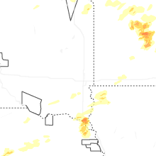


Connect with Interactive Hail Maps