

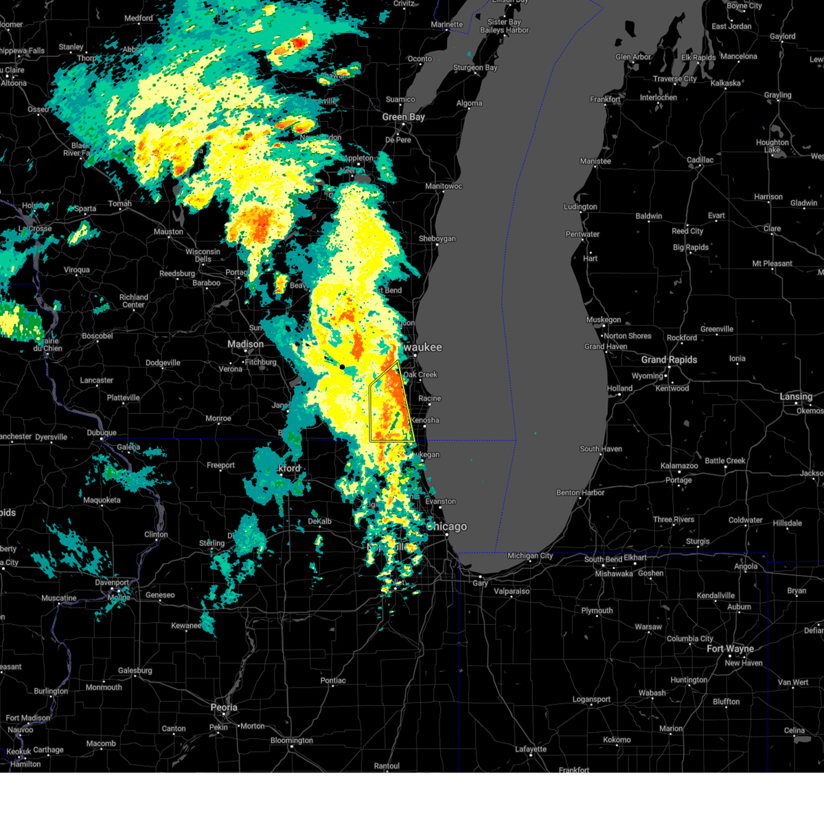
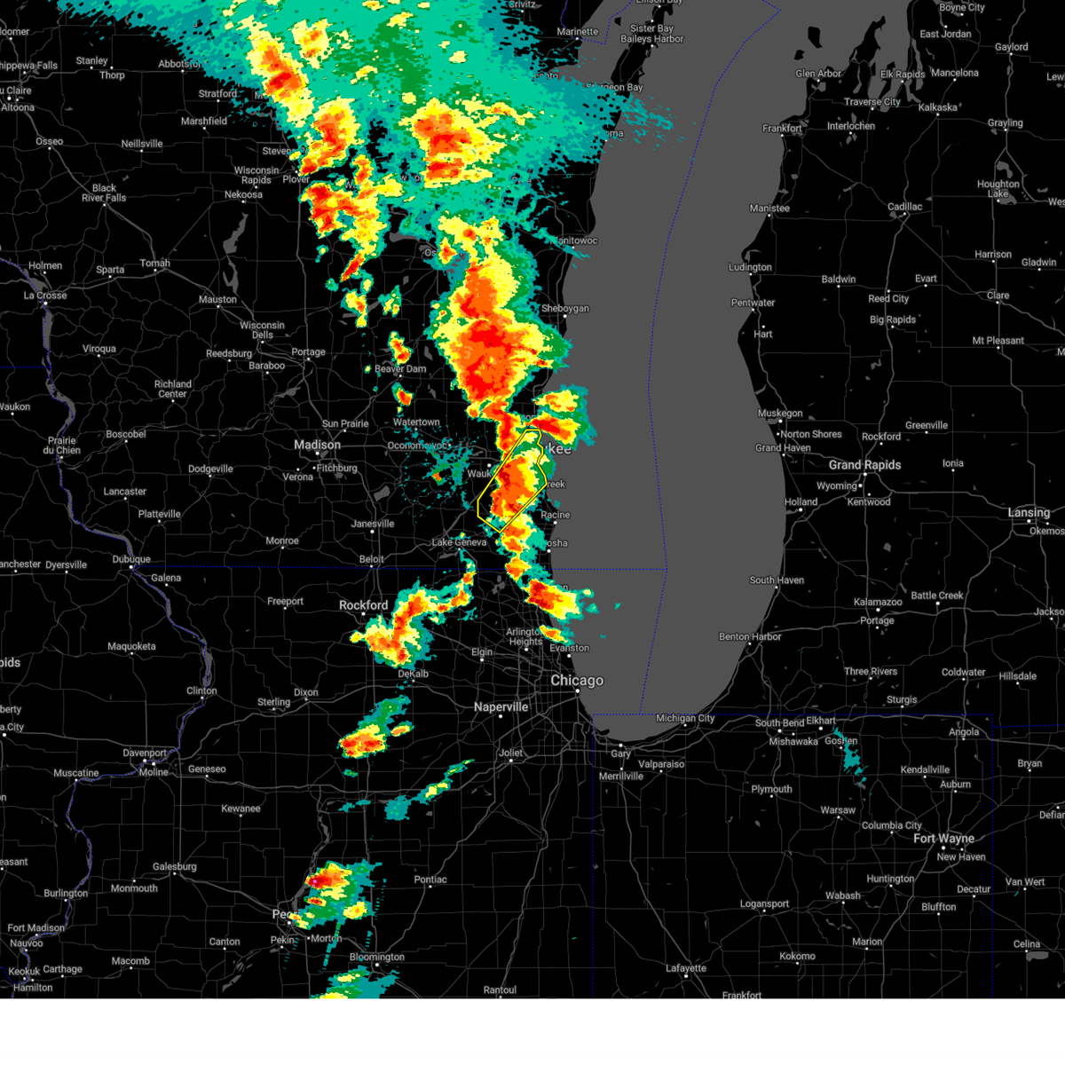
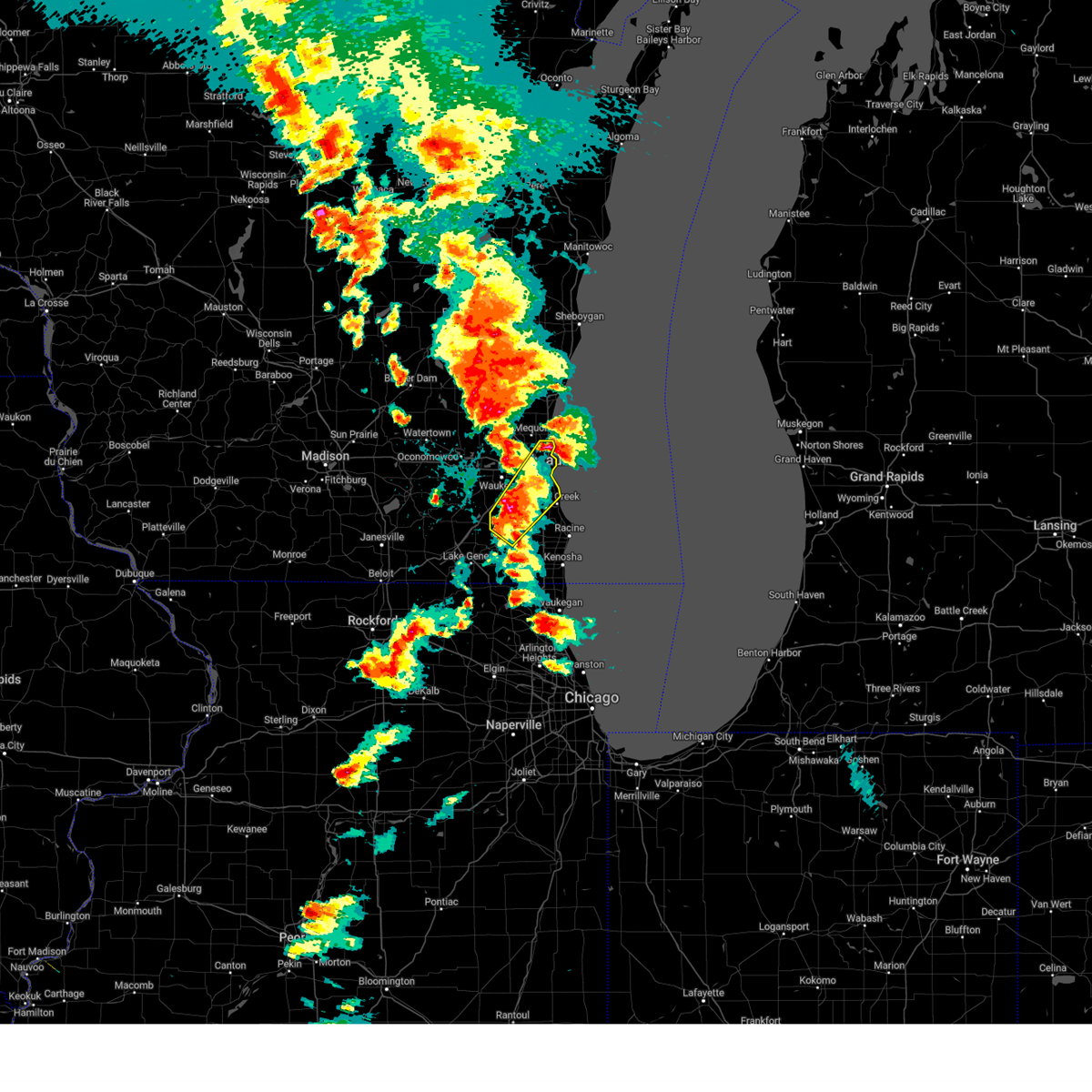
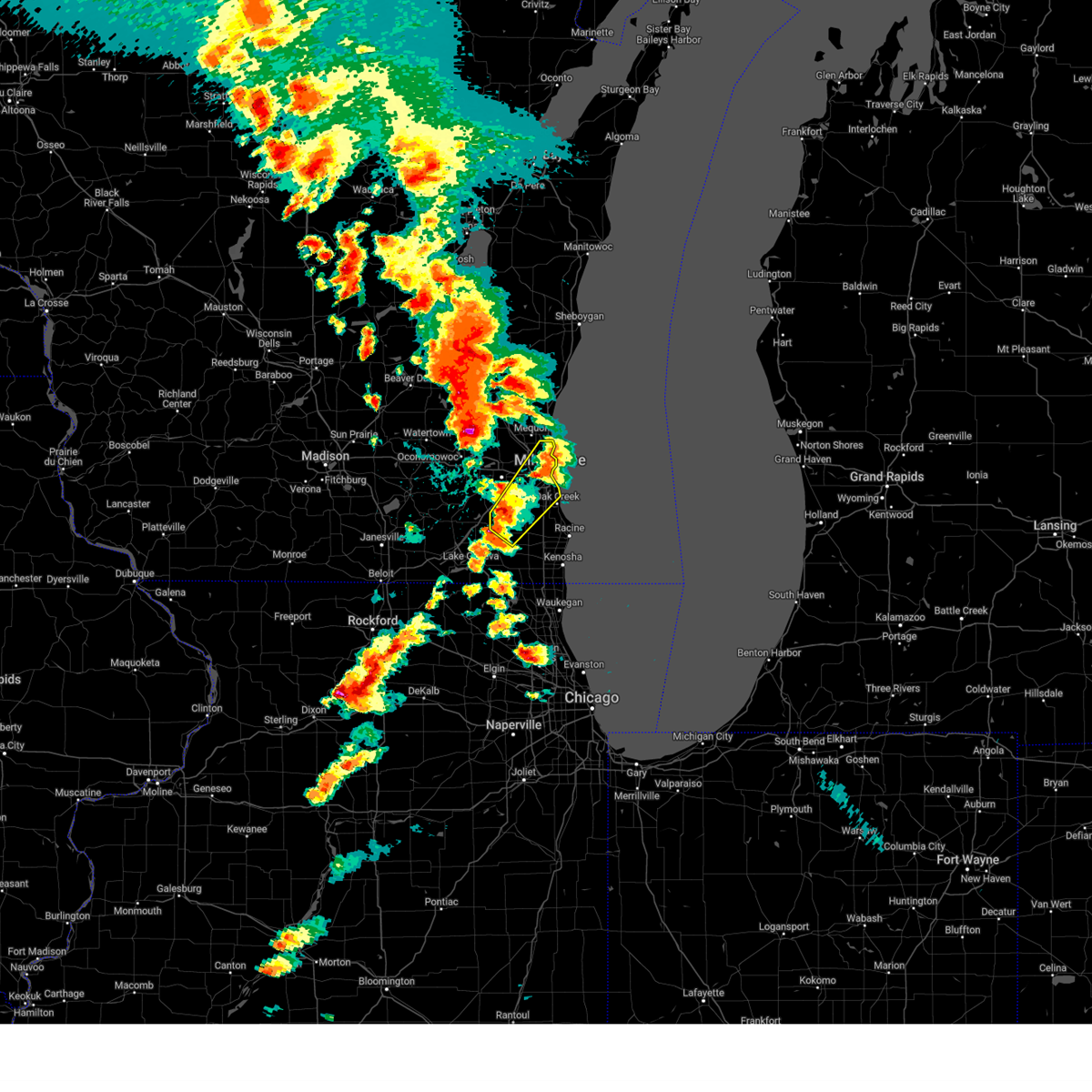
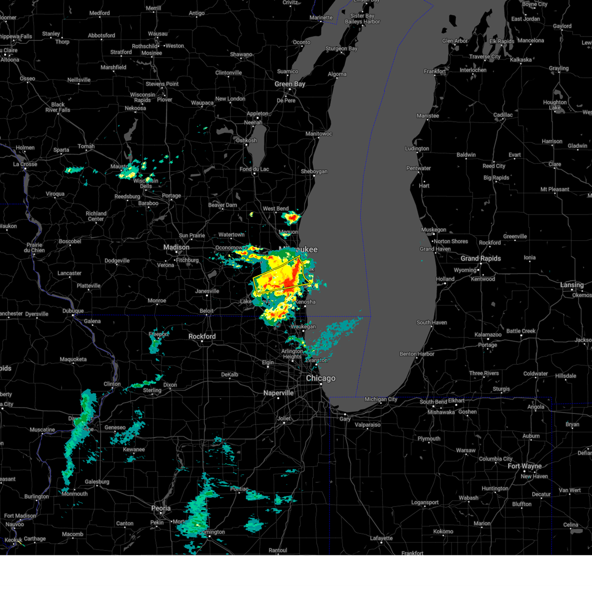
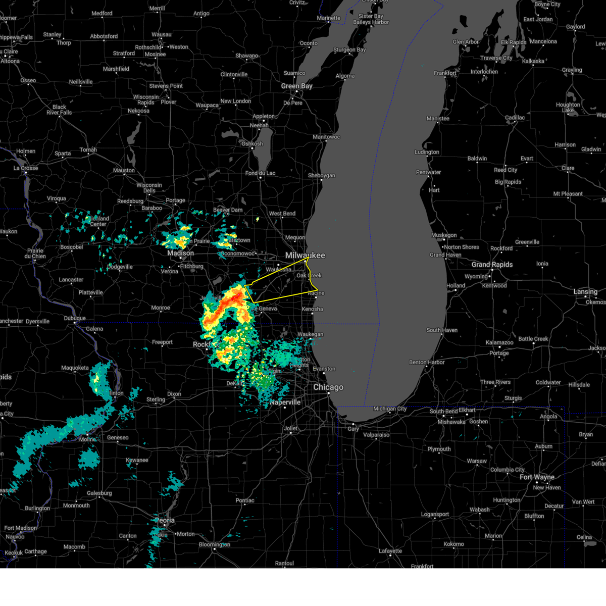
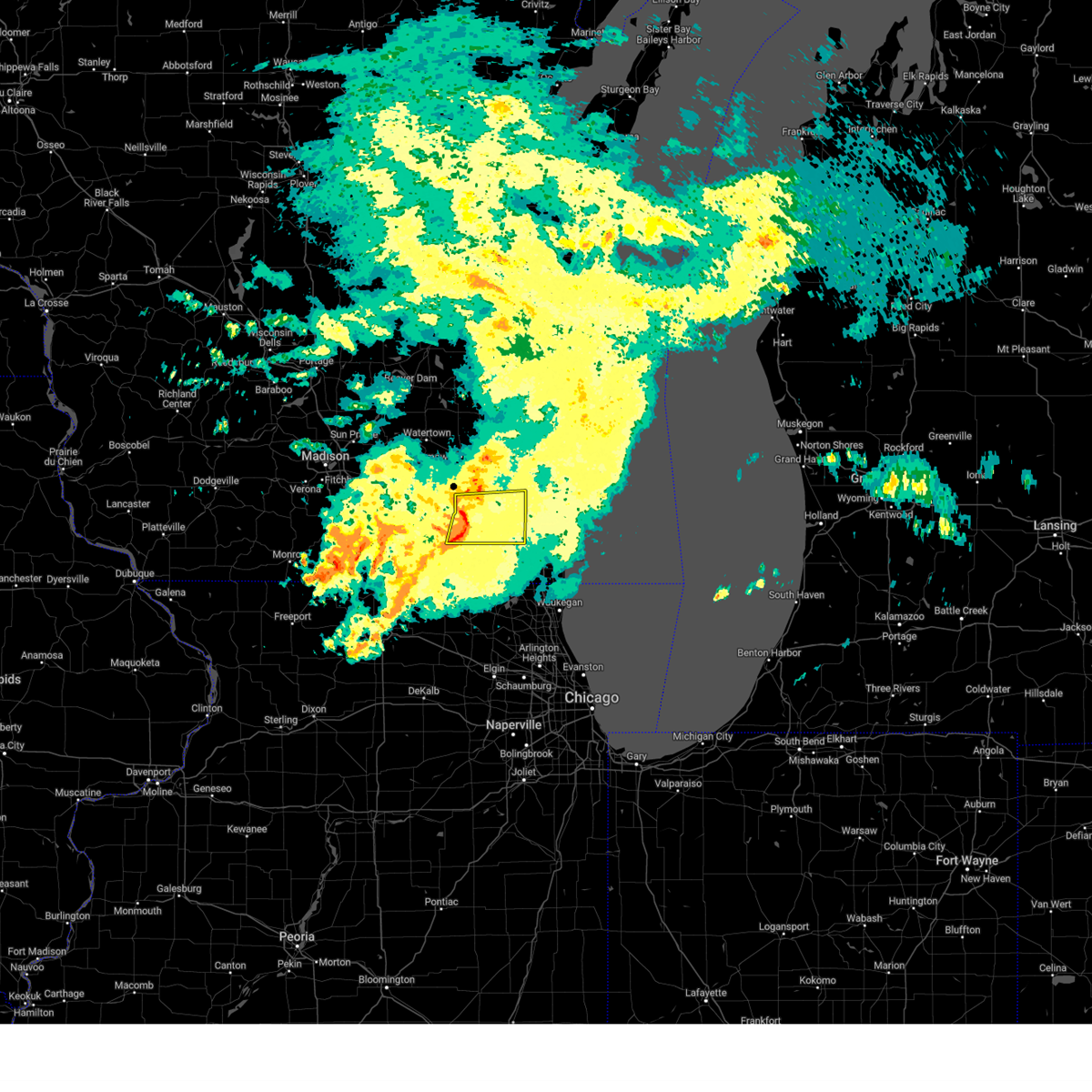
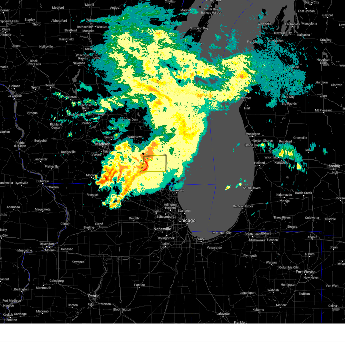
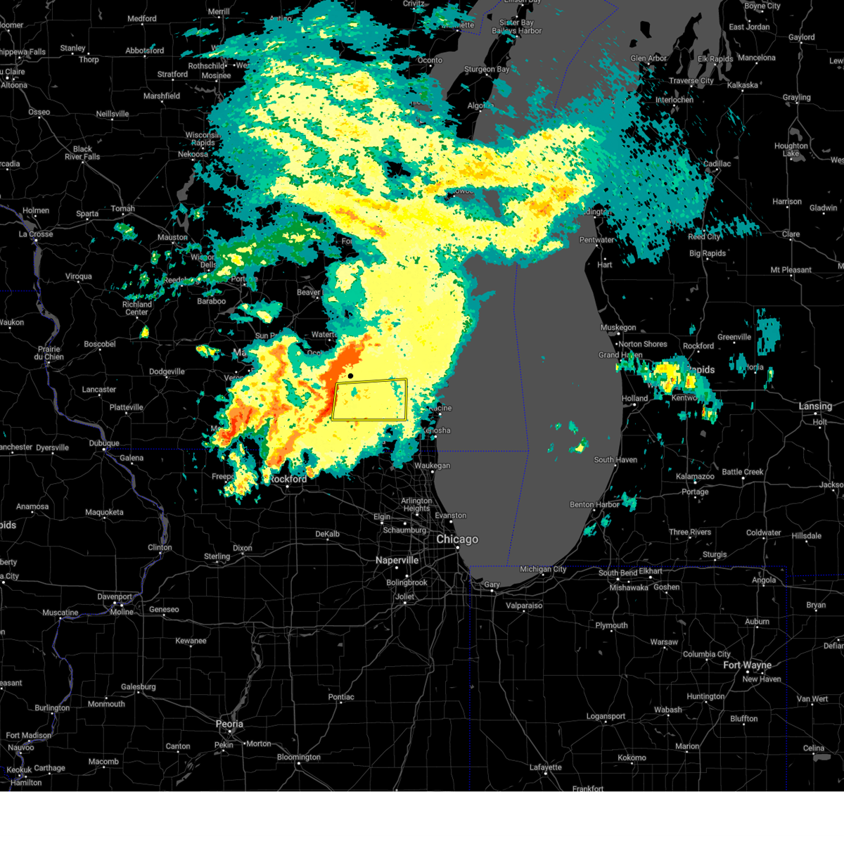
Hail Map for Waterford, WI
The Waterford, WI area has had 10 reports of on-the-ground hail by trained spotters, and has been under severe weather warnings 21 times during the past 12 months. Doppler radar has detected hail at or near Waterford, WI on 52 occasions, including 2 occasions during the past year.
| Name: | Waterford, WI |
| Where Located: | 63 miles ESE of Madison, WI |
| Map: | Google Map for Waterford, WI |
| Population: | 5368 |
| Housing Units: | 2272 |
| More Info: | Search Google for Waterford, WI |
3
The Top Recent Hail Date for Waterford, WI is Thursday, May 15, 2025 (11th out of 52)

Hail and Wind Damage Spotted near Waterford, WI
| Date / Time | Report Details |
|---|---|
| 6/3/2025 2:19 PM CDT |
 the severe thunderstorm warning has been cancelled and is no longer in effect the severe thunderstorm warning has been cancelled and is no longer in effect
|
| 6/3/2025 2:06 PM CDT |
 At 205 pm cdt, severe thunderstorms were located along a line extending from mukwonago to channel lake, moving east at 50 mph (radar indicated). Hazards include 60 mph wind gusts. Expect damage to roofs, siding, and trees. Locations impacted include, kenosha, west allis, new berlin, greenfield, muskego, pleasant prairie, antioch, hales corners, union grove, paddock lake, camp lake, wind lake, franklin, twin lakes, spring grove, rochester, raymond, wheatland, yorkville, and genoa city. At 205 pm cdt, severe thunderstorms were located along a line extending from mukwonago to channel lake, moving east at 50 mph (radar indicated). Hazards include 60 mph wind gusts. Expect damage to roofs, siding, and trees. Locations impacted include, kenosha, west allis, new berlin, greenfield, muskego, pleasant prairie, antioch, hales corners, union grove, paddock lake, camp lake, wind lake, franklin, twin lakes, spring grove, rochester, raymond, wheatland, yorkville, and genoa city.
|
| 6/3/2025 2:04 PM CDT |
 the severe thunderstorm warning has been cancelled and is no longer in effect the severe thunderstorm warning has been cancelled and is no longer in effect
|
| 6/3/2025 2:04 PM CDT |
 At 204 pm cdt, severe thunderstorms were located along a line extending from mukwonago to channel lake, moving east at 50 mph (radar indicated). Hazards include 60 mph wind gusts. Expect damage to roofs, siding, and trees. Locations impacted include, kenosha, west allis, new berlin, greenfield, muskego, pleasant prairie, antioch, hales corners, mukwonago, union grove, paddock lake, camp lake, wind lake, franklin, twin lakes, spring grove, rochester, raymond, wheatland, and yorkville. At 204 pm cdt, severe thunderstorms were located along a line extending from mukwonago to channel lake, moving east at 50 mph (radar indicated). Hazards include 60 mph wind gusts. Expect damage to roofs, siding, and trees. Locations impacted include, kenosha, west allis, new berlin, greenfield, muskego, pleasant prairie, antioch, hales corners, mukwonago, union grove, paddock lake, camp lake, wind lake, franklin, twin lakes, spring grove, rochester, raymond, wheatland, and yorkville.
|
| 6/3/2025 1:55 PM CDT |
 At 155 pm cdt, severe thunderstorms were located along a line extending from near east troy to spring grove, moving east at 50 mph (radar indicated). Hazards include 60 mph wind gusts. Expect damage to roofs, siding, and trees. Locations impacted include, kenosha, west allis, new berlin, greenfield, muskego, pleasant prairie, antioch, elkhorn, hales corners, lake geneva, union grove, east troy, paddock lake, camp lake, wind lake, franklin, twin lakes, spring grove, rochester, and raymond. At 155 pm cdt, severe thunderstorms were located along a line extending from near east troy to spring grove, moving east at 50 mph (radar indicated). Hazards include 60 mph wind gusts. Expect damage to roofs, siding, and trees. Locations impacted include, kenosha, west allis, new berlin, greenfield, muskego, pleasant prairie, antioch, elkhorn, hales corners, lake geneva, union grove, east troy, paddock lake, camp lake, wind lake, franklin, twin lakes, spring grove, rochester, and raymond.
|
| 6/3/2025 1:39 PM CDT |
 Svrmkx the national weather service in milwaukee/sullivan has issued a * severe thunderstorm warning for, southwestern milwaukee county in southeastern wisconsin, walworth county in southeastern wisconsin, racine county in southeastern wisconsin, southern waukesha county in southeastern wisconsin, kenosha county in southeastern wisconsin, * until 230 pm cdt. * at 138 pm cdt, severe thunderstorms were located along a line extending from near whitewater to near hebron, moving east at 50 mph (radar indicated). Hazards include 60 mph wind gusts. expect damage to roofs, siding, and trees Svrmkx the national weather service in milwaukee/sullivan has issued a * severe thunderstorm warning for, southwestern milwaukee county in southeastern wisconsin, walworth county in southeastern wisconsin, racine county in southeastern wisconsin, southern waukesha county in southeastern wisconsin, kenosha county in southeastern wisconsin, * until 230 pm cdt. * at 138 pm cdt, severe thunderstorms were located along a line extending from near whitewater to near hebron, moving east at 50 mph (radar indicated). Hazards include 60 mph wind gusts. expect damage to roofs, siding, and trees
|
| 5/15/2025 6:45 PM CDT |
 At 644 pm cdt, a severe thunderstorm was located over west allis, moving northeast at 55 mph (public report of ping pong ball sized hail near hales corner). Hazards include golf ball size hail and 60 mph wind gusts. People and animals outdoors will be injured. expect hail damage to roofs, siding, windows, and vehicles. expect wind damage to roofs, siding, and trees. locations impacted include, milwaukee, west allis, wauwatosa, new berlin, brookfield, greenfield, oak creek, muskego, south milwaukee, cudahy, whitefish bay, greendale, brown deer, st. Francis, hales corners, fox point, elm grove, bayside, west milwaukee, and franklin. At 644 pm cdt, a severe thunderstorm was located over west allis, moving northeast at 55 mph (public report of ping pong ball sized hail near hales corner). Hazards include golf ball size hail and 60 mph wind gusts. People and animals outdoors will be injured. expect hail damage to roofs, siding, windows, and vehicles. expect wind damage to roofs, siding, and trees. locations impacted include, milwaukee, west allis, wauwatosa, new berlin, brookfield, greenfield, oak creek, muskego, south milwaukee, cudahy, whitefish bay, greendale, brown deer, st. Francis, hales corners, fox point, elm grove, bayside, west milwaukee, and franklin.
|
| 5/15/2025 6:42 PM CDT | Quarter sized hail reported 5.2 miles SSW of Waterford, WI, report from mping: quarter (1.00 in.). |
| 5/15/2025 6:34 PM CDT |
 At 634 pm cdt, a severe thunderstorm was located over muskego, and is nearly stationary (radar indicated). Hazards include golf ball size hail and 60 mph wind gusts. People and animals outdoors will be injured. expect hail damage to roofs, siding, windows, and vehicles. expect wind damage to roofs, siding, and trees. locations impacted include, milwaukee, west allis, wauwatosa, new berlin, brookfield, greenfield, oak creek, muskego, south milwaukee, cudahy, whitefish bay, greendale, brown deer, st. Francis, hales corners, fox point, elm grove, bayside, west milwaukee, and franklin. At 634 pm cdt, a severe thunderstorm was located over muskego, and is nearly stationary (radar indicated). Hazards include golf ball size hail and 60 mph wind gusts. People and animals outdoors will be injured. expect hail damage to roofs, siding, windows, and vehicles. expect wind damage to roofs, siding, and trees. locations impacted include, milwaukee, west allis, wauwatosa, new berlin, brookfield, greenfield, oak creek, muskego, south milwaukee, cudahy, whitefish bay, greendale, brown deer, st. Francis, hales corners, fox point, elm grove, bayside, west milwaukee, and franklin.
|
| 5/15/2025 6:24 PM CDT |
 Svrmkx the national weather service in milwaukee/sullivan has issued a * severe thunderstorm warning for, milwaukee county in southeastern wisconsin, northwestern racine county in southeastern wisconsin, southeastern waukesha county in southeastern wisconsin, * until 700 pm cdt. * at 623 pm cdt, a cluster of severe thunderstorms was located over waterford north, or over wind lake, moving northeast at 55 mph (radar indicated). Hazards include 60 mph wind gusts and half dollar size hail. Hail damage to vehicles is expected. Expect wind damage to roofs, siding, and trees. Svrmkx the national weather service in milwaukee/sullivan has issued a * severe thunderstorm warning for, milwaukee county in southeastern wisconsin, northwestern racine county in southeastern wisconsin, southeastern waukesha county in southeastern wisconsin, * until 700 pm cdt. * at 623 pm cdt, a cluster of severe thunderstorms was located over waterford north, or over wind lake, moving northeast at 55 mph (radar indicated). Hazards include 60 mph wind gusts and half dollar size hail. Hail damage to vehicles is expected. Expect wind damage to roofs, siding, and trees.
|
| 4/18/2025 3:31 PM CDT |
 At 330 pm cdt, a severe thunderstorm was located over hales corners, moving east at 65 mph (radar indicated). Hazards include quarter size hail. Damage to vehicles is expected. locations impacted include, muskego, franklin, raymond, waterford, south milwaukee, mukwonago, north cape, waterford north, milwaukee south shore park, cudahy, potter lake, oak creek, st. Francis, rochester, east troy, honey creek, caledonia, vernon, greenfield, and wind lake. At 330 pm cdt, a severe thunderstorm was located over hales corners, moving east at 65 mph (radar indicated). Hazards include quarter size hail. Damage to vehicles is expected. locations impacted include, muskego, franklin, raymond, waterford, south milwaukee, mukwonago, north cape, waterford north, milwaukee south shore park, cudahy, potter lake, oak creek, st. Francis, rochester, east troy, honey creek, caledonia, vernon, greenfield, and wind lake.
|
| 4/18/2025 3:04 PM CDT |
 Svrmkx the national weather service in milwaukee/sullivan has issued a * severe thunderstorm warning for, milwaukee county in southeastern wisconsin, northeastern walworth county in southeastern wisconsin, northern racine county in southeastern wisconsin, southern waukesha county in southeastern wisconsin, * until 345 pm cdt. * at 304 pm cdt, a severe thunderstorm was located near elkhorn, moving east at 65 mph (radar indicated). Hazards include quarter size hail. damage to vehicles is expected Svrmkx the national weather service in milwaukee/sullivan has issued a * severe thunderstorm warning for, milwaukee county in southeastern wisconsin, northeastern walworth county in southeastern wisconsin, northern racine county in southeastern wisconsin, southern waukesha county in southeastern wisconsin, * until 345 pm cdt. * at 304 pm cdt, a severe thunderstorm was located near elkhorn, moving east at 65 mph (radar indicated). Hazards include quarter size hail. damage to vehicles is expected
|
| 4/18/2025 8:46 AM CDT |
 Svrmkx the national weather service in milwaukee/sullivan has issued a * severe thunderstorm warning for, southern milwaukee county in southeastern wisconsin, racine county in southeastern wisconsin, southeastern waukesha county in southeastern wisconsin, * until 915 am cdt. * at 846 am cdt, severe thunderstorms were located along a line extending from muskego to eagle lake, moving east at 70 mph (radar indicated). Hazards include quarter size hail. damage to vehicles is expected Svrmkx the national weather service in milwaukee/sullivan has issued a * severe thunderstorm warning for, southern milwaukee county in southeastern wisconsin, racine county in southeastern wisconsin, southeastern waukesha county in southeastern wisconsin, * until 915 am cdt. * at 846 am cdt, severe thunderstorms were located along a line extending from muskego to eagle lake, moving east at 70 mph (radar indicated). Hazards include quarter size hail. damage to vehicles is expected
|
| 3/15/2025 12:18 AM CDT | Svrmkx the national weather service in milwaukee/sullivan has issued a * severe thunderstorm warning for, racine county in southeastern wisconsin, kenosha county in southeastern wisconsin, * until 1245 am cdt. * at 1217 am cdt, severe thunderstorms were located along a line extending from near browns lake to long lake, moving east at 50 mph (radar indicated). Hazards include 60 mph wind gusts. expect damage to roofs, siding, and trees |
| 8/6/2024 2:39 AM CDT |
 The storm which prompted the warning has weakened below severe limits, and no longer poses an immediate threat to life or property. therefore, the warning will be allowed to expire. however, gusty winds are still possible with this thunderstorm. The storm which prompted the warning has weakened below severe limits, and no longer poses an immediate threat to life or property. therefore, the warning will be allowed to expire. however, gusty winds are still possible with this thunderstorm.
|
| 8/6/2024 2:33 AM CDT |
 At 231 am cdt, a severe thunderstorm was located over browns lake, or 8 miles west of union grove, moving east at 40 mph (radar indicated). Hazards include 60 mph wind gusts. Expect damage to roofs, siding, and trees. Locations impacted include, wind lake, rochester, waterford north, eagle lake, browns lake, burlington, waterford, and honey creek. At 231 am cdt, a severe thunderstorm was located over browns lake, or 8 miles west of union grove, moving east at 40 mph (radar indicated). Hazards include 60 mph wind gusts. Expect damage to roofs, siding, and trees. Locations impacted include, wind lake, rochester, waterford north, eagle lake, browns lake, burlington, waterford, and honey creek.
|
| 8/6/2024 2:33 AM CDT |
 the severe thunderstorm warning has been cancelled and is no longer in effect the severe thunderstorm warning has been cancelled and is no longer in effect
|
| 8/6/2024 2:17 AM CDT |
 the severe thunderstorm warning has been cancelled and is no longer in effect the severe thunderstorm warning has been cancelled and is no longer in effect
|
| 8/6/2024 2:17 AM CDT |
 At 216 am cdt, a severe thunderstorm was located over east troy, moving east at 45 mph (radar indicated). Hazards include 60 mph wind gusts. Expect damage to roofs, siding, and trees. Locations impacted include, new berlin, muskego, elkhorn, mukwonago, east troy, wind lake, vernon, rochester, north prairie, big bend, waterford north, potter lake, eagle lake, browns lake, burlington, waterford, eagle, honey creek, abells corners, and tibbets. At 216 am cdt, a severe thunderstorm was located over east troy, moving east at 45 mph (radar indicated). Hazards include 60 mph wind gusts. Expect damage to roofs, siding, and trees. Locations impacted include, new berlin, muskego, elkhorn, mukwonago, east troy, wind lake, vernon, rochester, north prairie, big bend, waterford north, potter lake, eagle lake, browns lake, burlington, waterford, eagle, honey creek, abells corners, and tibbets.
|
| 8/6/2024 2:03 AM CDT |
 Svrmkx the national weather service in milwaukee/sullivan has issued a * severe thunderstorm warning for, northern walworth county in southeastern wisconsin, northwestern racine county in southeastern wisconsin, southern waukesha county in southeastern wisconsin, southeastern jefferson county in southeastern wisconsin, * until 245 am cdt. * at 202 am cdt, a severe thunderstorm was located near palmyra, or 8 miles east of whitewater, moving east at 50 mph (radar indicated). Hazards include 60 mph wind gusts. expect damage to roofs, siding, and trees Svrmkx the national weather service in milwaukee/sullivan has issued a * severe thunderstorm warning for, northern walworth county in southeastern wisconsin, northwestern racine county in southeastern wisconsin, southern waukesha county in southeastern wisconsin, southeastern jefferson county in southeastern wisconsin, * until 245 am cdt. * at 202 am cdt, a severe thunderstorm was located near palmyra, or 8 miles east of whitewater, moving east at 50 mph (radar indicated). Hazards include 60 mph wind gusts. expect damage to roofs, siding, and trees
|
| 7/14/2024 9:45 PM CDT |
 the severe thunderstorm warning has been cancelled and is no longer in effect the severe thunderstorm warning has been cancelled and is no longer in effect
|
| 7/14/2024 9:22 PM CDT |
 Svrmkx the national weather service in milwaukee/sullivan has issued a * severe thunderstorm warning for, northeastern walworth county in southeastern wisconsin, western racine county in southeastern wisconsin, * until 1000 pm cdt. * at 922 pm cdt, severe thunderstorms were located along a line extending from near palmyra to near east troy to near lake geneva, moving east at 40 mph (radar indicated). Hazards include 60 mph wind gusts and penny size hail. expect damage to roofs, siding, and trees Svrmkx the national weather service in milwaukee/sullivan has issued a * severe thunderstorm warning for, northeastern walworth county in southeastern wisconsin, western racine county in southeastern wisconsin, * until 1000 pm cdt. * at 922 pm cdt, severe thunderstorms were located along a line extending from near palmyra to near east troy to near lake geneva, moving east at 40 mph (radar indicated). Hazards include 60 mph wind gusts and penny size hail. expect damage to roofs, siding, and trees
|
| 6/22/2024 8:18 PM CDT |
 Svrmkx the national weather service in milwaukee/sullivan has issued a * severe thunderstorm warning for, eastern walworth county in southeastern wisconsin, racine county in southeastern wisconsin, kenosha county in southeastern wisconsin, * until 930 pm cdt. * at 817 pm cdt, severe thunderstorms were located along a line extending from near east troy to elkhorn to near sharon, moving east at 35 mph (radar indicated). Hazards include 60 mph wind gusts and quarter size hail. Hail damage to vehicles is expected. Expect wind damage to roofs, siding, and trees. Svrmkx the national weather service in milwaukee/sullivan has issued a * severe thunderstorm warning for, eastern walworth county in southeastern wisconsin, racine county in southeastern wisconsin, kenosha county in southeastern wisconsin, * until 930 pm cdt. * at 817 pm cdt, severe thunderstorms were located along a line extending from near east troy to elkhorn to near sharon, moving east at 35 mph (radar indicated). Hazards include 60 mph wind gusts and quarter size hail. Hail damage to vehicles is expected. Expect wind damage to roofs, siding, and trees.
|
| 5/26/2024 6:16 PM CDT |
 At 616 pm cdt, severe thunderstorms capable of producing tornadoes were located along a line extending from potter lake to near bohners lake, moving east at 25 mph (radar indicated rotation). Hazards include tornado. Flying debris will be dangerous to those caught without shelter. mobile homes will be damaged or destroyed. damage to roofs, windows, and vehicles will occur. tree damage is likely. locations impacted include, east troy, rochester, browns lake, bohners lake, potter lake, waterford north, burlington, waterford, and honey creek. People attending the burlington jamboree should seek safe shelter immediately!. At 616 pm cdt, severe thunderstorms capable of producing tornadoes were located along a line extending from potter lake to near bohners lake, moving east at 25 mph (radar indicated rotation). Hazards include tornado. Flying debris will be dangerous to those caught without shelter. mobile homes will be damaged or destroyed. damage to roofs, windows, and vehicles will occur. tree damage is likely. locations impacted include, east troy, rochester, browns lake, bohners lake, potter lake, waterford north, burlington, waterford, and honey creek. People attending the burlington jamboree should seek safe shelter immediately!.
|
| 5/26/2024 6:16 PM CDT |
 the tornado warning has been cancelled and is no longer in effect the tornado warning has been cancelled and is no longer in effect
|
| 5/26/2024 5:58 PM CDT |
 Tormkx the national weather service in milwaukee/sullivan has issued a * tornado warning for, eastern walworth county in southeastern wisconsin, western racine county in southeastern wisconsin, southwestern waukesha county in southeastern wisconsin, * until 630 pm cdt. * at 557 pm cdt, severe thunderstorms capable of producing a tornado were located along a line extending from near palmyra to como, moving northeast at 25 mph (radar indicated rotation). Hazards include tornado. Flying debris will be dangerous to those caught without shelter. mobile homes will be damaged or destroyed. damage to roofs, windows, and vehicles will occur. Tree damage is likely. Tormkx the national weather service in milwaukee/sullivan has issued a * tornado warning for, eastern walworth county in southeastern wisconsin, western racine county in southeastern wisconsin, southwestern waukesha county in southeastern wisconsin, * until 630 pm cdt. * at 557 pm cdt, severe thunderstorms capable of producing a tornado were located along a line extending from near palmyra to como, moving northeast at 25 mph (radar indicated rotation). Hazards include tornado. Flying debris will be dangerous to those caught without shelter. mobile homes will be damaged or destroyed. damage to roofs, windows, and vehicles will occur. Tree damage is likely.
|
| 5/22/2024 12:17 AM CDT |
 the severe thunderstorm warning has been cancelled and is no longer in effect the severe thunderstorm warning has been cancelled and is no longer in effect
|
| 5/22/2024 12:17 AM CDT |
 At 1217 am cdt, a severe thunderstorm was located over muskego, moving northeast at 55 mph (radar indicated). Hazards include 60 mph wind gusts and penny size hail. Expect damage to roofs, siding, and trees. Locations impacted include, waukesha, new berlin, muskego, wind lake, vernon, rochester, big bend, waterford north, browns lake, burlington, waterford, and honey creek. At 1217 am cdt, a severe thunderstorm was located over muskego, moving northeast at 55 mph (radar indicated). Hazards include 60 mph wind gusts and penny size hail. Expect damage to roofs, siding, and trees. Locations impacted include, waukesha, new berlin, muskego, wind lake, vernon, rochester, big bend, waterford north, browns lake, burlington, waterford, and honey creek.
|
| 5/22/2024 12:00 AM CDT |
 At 1200 am cdt, a severe thunderstorm was located near east troy, moving northeast at 55 mph (radar indicated). Hazards include 60 mph wind gusts and penny size hail. Expect damage to roofs, siding, and trees. Locations impacted include, waukesha, new berlin, muskego, elkhorn, lake geneva, mukwonago, east troy, williams bay, wind lake, vernon, rochester, fontana-on-geneva lake, big bend, como, waterford north, potter lake, browns lake, burlington, waterford, and springfield. At 1200 am cdt, a severe thunderstorm was located near east troy, moving northeast at 55 mph (radar indicated). Hazards include 60 mph wind gusts and penny size hail. Expect damage to roofs, siding, and trees. Locations impacted include, waukesha, new berlin, muskego, elkhorn, lake geneva, mukwonago, east troy, williams bay, wind lake, vernon, rochester, fontana-on-geneva lake, big bend, como, waterford north, potter lake, browns lake, burlington, waterford, and springfield.
|
| 5/21/2024 11:47 PM CDT |
 Svrmkx the national weather service in milwaukee/sullivan has issued a * severe thunderstorm warning for, central walworth county in southeastern wisconsin, northwestern racine county in southeastern wisconsin, southeastern waukesha county in southeastern wisconsin, * until 1230 am cdt. * at 1147 pm cdt, a severe thunderstorm was located over williams bay, moving northeast at 55 mph (radar indicated). Hazards include 60 mph wind gusts. expect damage to roofs, siding, and trees Svrmkx the national weather service in milwaukee/sullivan has issued a * severe thunderstorm warning for, central walworth county in southeastern wisconsin, northwestern racine county in southeastern wisconsin, southeastern waukesha county in southeastern wisconsin, * until 1230 am cdt. * at 1147 pm cdt, a severe thunderstorm was located over williams bay, moving northeast at 55 mph (radar indicated). Hazards include 60 mph wind gusts. expect damage to roofs, siding, and trees
|
| 5/7/2024 8:58 PM CDT |
 At 858 pm cdt, severe thunderstorms were located along a line extending from lisbon to muskego to near wheatland, moving east at 45 mph (radar indicated). Hazards include 60 mph wind gusts and quarter size hail. Hail damage to vehicles is expected. expect wind damage to roofs, siding, and trees. Locations impacted include, milwaukee, kenosha, racine, waukesha, west allis, wauwatosa, new berlin, brookfield, greenfield, menomonee falls, oak creek, mount pleasant, muskego, south milwaukee, cudahy, whitefish bay, greendale, pewaukee, brown deer, and sussex. At 858 pm cdt, severe thunderstorms were located along a line extending from lisbon to muskego to near wheatland, moving east at 45 mph (radar indicated). Hazards include 60 mph wind gusts and quarter size hail. Hail damage to vehicles is expected. expect wind damage to roofs, siding, and trees. Locations impacted include, milwaukee, kenosha, racine, waukesha, west allis, wauwatosa, new berlin, brookfield, greenfield, menomonee falls, oak creek, mount pleasant, muskego, south milwaukee, cudahy, whitefish bay, greendale, pewaukee, brown deer, and sussex.
|
| 5/7/2024 8:58 PM CDT |
 the severe thunderstorm warning has been cancelled and is no longer in effect the severe thunderstorm warning has been cancelled and is no longer in effect
|
| 5/7/2024 8:43 PM CDT |
 Svrmkx the national weather service in milwaukee/sullivan has issued a * severe thunderstorm warning for, milwaukee county in southeastern wisconsin, northeastern walworth county in southeastern wisconsin, racine county in southeastern wisconsin, eastern waukesha county in southeastern wisconsin, northern kenosha county in southeastern wisconsin, * until 930 pm cdt. * at 843 pm cdt, severe thunderstorms were located along a line extending from near okauchee lake to vernon to near lake geneva, moving east at 45 mph (radar indicated). Hazards include 60 mph wind gusts and quarter size hail. Hail damage to vehicles is expected. Expect wind damage to roofs, siding, and trees. Svrmkx the national weather service in milwaukee/sullivan has issued a * severe thunderstorm warning for, milwaukee county in southeastern wisconsin, northeastern walworth county in southeastern wisconsin, racine county in southeastern wisconsin, eastern waukesha county in southeastern wisconsin, northern kenosha county in southeastern wisconsin, * until 930 pm cdt. * at 843 pm cdt, severe thunderstorms were located along a line extending from near okauchee lake to vernon to near lake geneva, moving east at 45 mph (radar indicated). Hazards include 60 mph wind gusts and quarter size hail. Hail damage to vehicles is expected. Expect wind damage to roofs, siding, and trees.
|
| 5/7/2024 3:14 PM CDT |
 Svrmkx the national weather service in milwaukee/sullivan has issued a * severe thunderstorm warning for, southern milwaukee county in southeastern wisconsin, northwestern racine county in southeastern wisconsin, southeastern waukesha county in southeastern wisconsin, * until 400 pm cdt. * at 313 pm cdt, a severe thunderstorm was located near wind lake, moving northeast at 40 mph (radar indicated). Hazards include 60 mph wind gusts and nickel size hail. expect damage to roofs, siding, and trees Svrmkx the national weather service in milwaukee/sullivan has issued a * severe thunderstorm warning for, southern milwaukee county in southeastern wisconsin, northwestern racine county in southeastern wisconsin, southeastern waukesha county in southeastern wisconsin, * until 400 pm cdt. * at 313 pm cdt, a severe thunderstorm was located near wind lake, moving northeast at 40 mph (radar indicated). Hazards include 60 mph wind gusts and nickel size hail. expect damage to roofs, siding, and trees
|
| 5/7/2024 3:03 PM CDT |
 At 303 pm cdt, a severe thunderstorm was located over waterford north, or near wind lake, moving northeast at 40 mph (radar indicated). Hazards include 60 mph wind gusts and penny size hail. Expect damage to roofs, siding, and trees. Locations impacted include, east troy, wind lake, rochester, waterford north, potter lake, browns lake, burlington, waterford, and honey creek. At 303 pm cdt, a severe thunderstorm was located over waterford north, or near wind lake, moving northeast at 40 mph (radar indicated). Hazards include 60 mph wind gusts and penny size hail. Expect damage to roofs, siding, and trees. Locations impacted include, east troy, wind lake, rochester, waterford north, potter lake, browns lake, burlington, waterford, and honey creek.
|
| 5/7/2024 2:49 PM CDT |
 At 249 pm cdt, a severe thunderstorm was located near east troy, moving northeast at 35 mph (radar indicated). Hazards include 60 mph wind gusts and penny size hail. Expect damage to roofs, siding, and trees. Locations impacted include, elkhorn, delavan, lake geneva, east troy, wind lake, rochester, como, waterford north, potter lake, browns lake, burlington, waterford, springfield, honey creek, troy center, abells corners, and delavan lake. At 249 pm cdt, a severe thunderstorm was located near east troy, moving northeast at 35 mph (radar indicated). Hazards include 60 mph wind gusts and penny size hail. Expect damage to roofs, siding, and trees. Locations impacted include, elkhorn, delavan, lake geneva, east troy, wind lake, rochester, como, waterford north, potter lake, browns lake, burlington, waterford, springfield, honey creek, troy center, abells corners, and delavan lake.
|
| 5/7/2024 2:33 PM CDT |
 Svrmkx the national weather service in milwaukee/sullivan has issued a * severe thunderstorm warning for, central walworth county in southeastern wisconsin, northwestern racine county in southeastern wisconsin, * until 315 pm cdt. * at 233 pm cdt, a severe thunderstorm was located near williams bay, moving northeast at 40 mph (radar indicated). Hazards include 60 mph wind gusts and quarter size hail. Hail damage to vehicles is expected. Expect wind damage to roofs, siding, and trees. Svrmkx the national weather service in milwaukee/sullivan has issued a * severe thunderstorm warning for, central walworth county in southeastern wisconsin, northwestern racine county in southeastern wisconsin, * until 315 pm cdt. * at 233 pm cdt, a severe thunderstorm was located near williams bay, moving northeast at 40 mph (radar indicated). Hazards include 60 mph wind gusts and quarter size hail. Hail damage to vehicles is expected. Expect wind damage to roofs, siding, and trees.
|
| 4/27/2024 10:43 PM CDT |
 At 1043 pm cdt, severe thunderstorms were located along a line extending from near greenfield to yorkville to near wheatland, moving east at 35 mph (radar indicated). Hazards include 60 mph wind gusts. Expect damage to roofs, siding, and trees. locations impacted include, milwaukee, kenosha, racine, waukesha, west allis, new berlin, greenfield, oak creek, mount pleasant, muskego, south milwaukee, cudahy, greendale, pewaukee, elkhorn, st. Francis, hales corners, lake geneva, mukwonago, and sturtevant. At 1043 pm cdt, severe thunderstorms were located along a line extending from near greenfield to yorkville to near wheatland, moving east at 35 mph (radar indicated). Hazards include 60 mph wind gusts. Expect damage to roofs, siding, and trees. locations impacted include, milwaukee, kenosha, racine, waukesha, west allis, new berlin, greenfield, oak creek, mount pleasant, muskego, south milwaukee, cudahy, greendale, pewaukee, elkhorn, st. Francis, hales corners, lake geneva, mukwonago, and sturtevant.
|
| 4/27/2024 10:31 PM CDT |
 the severe thunderstorm warning has been cancelled and is no longer in effect the severe thunderstorm warning has been cancelled and is no longer in effect
|
| 4/27/2024 10:31 PM CDT |
 At 1031 pm cdt, severe thunderstorms were located along a line extending from hales corners to near eagle lake to near lake geneva, moving east at 35 mph (radar indicated). Hazards include 60 mph wind gusts. Expect damage to roofs, siding, and trees. locations impacted include, milwaukee, kenosha, racine, waukesha, west allis, new berlin, greenfield, oak creek, mount pleasant, muskego, south milwaukee, cudahy, greendale, pewaukee, elkhorn, st. Francis, delavan, hales corners, lake geneva, and mukwonago. At 1031 pm cdt, severe thunderstorms were located along a line extending from hales corners to near eagle lake to near lake geneva, moving east at 35 mph (radar indicated). Hazards include 60 mph wind gusts. Expect damage to roofs, siding, and trees. locations impacted include, milwaukee, kenosha, racine, waukesha, west allis, new berlin, greenfield, oak creek, mount pleasant, muskego, south milwaukee, cudahy, greendale, pewaukee, elkhorn, st. Francis, delavan, hales corners, lake geneva, and mukwonago.
|
| 4/27/2024 10:01 PM CDT |
 Svrmkx the national weather service in milwaukee/sullivan has issued a * severe thunderstorm warning for, southern milwaukee county in southeastern wisconsin, walworth county in southeastern wisconsin, racine county in southeastern wisconsin, southern waukesha county in southeastern wisconsin, southeastern jefferson county in southeastern wisconsin, northern kenosha county in southeastern wisconsin, * until 1115 pm cdt. * at 1001 pm cdt, severe thunderstorms were located along a line extending from ottawa to near east troy to darien, moving east at 35 mph (radar indicated). Hazards include 60 mph wind gusts. expect damage to roofs, siding, and trees Svrmkx the national weather service in milwaukee/sullivan has issued a * severe thunderstorm warning for, southern milwaukee county in southeastern wisconsin, walworth county in southeastern wisconsin, racine county in southeastern wisconsin, southern waukesha county in southeastern wisconsin, southeastern jefferson county in southeastern wisconsin, northern kenosha county in southeastern wisconsin, * until 1115 pm cdt. * at 1001 pm cdt, severe thunderstorms were located along a line extending from ottawa to near east troy to darien, moving east at 35 mph (radar indicated). Hazards include 60 mph wind gusts. expect damage to roofs, siding, and trees
|
| 3/4/2024 5:03 PM CST |
 At 503 pm cst, a severe thunderstorm was located over new berlin, moving northeast at 40 mph (radar indicated). Hazards include 60 mph wind gusts and quarter size hail. Hail damage to vehicles is expected. expect wind damage to roofs, siding, and trees. Locations impacted include, waukesha, new berlin, muskego, elkhorn, mukwonago, east troy, wind lake, vernon, big bend, waterford north, potter lake, brookfield, waterford, abells corners, tibbets, millard, and troy center. At 503 pm cst, a severe thunderstorm was located over new berlin, moving northeast at 40 mph (radar indicated). Hazards include 60 mph wind gusts and quarter size hail. Hail damage to vehicles is expected. expect wind damage to roofs, siding, and trees. Locations impacted include, waukesha, new berlin, muskego, elkhorn, mukwonago, east troy, wind lake, vernon, big bend, waterford north, potter lake, brookfield, waterford, abells corners, tibbets, millard, and troy center.
|
| 3/4/2024 4:30 PM CST |
 Svrmkx the national weather service in milwaukee/sullivan has issued a * severe thunderstorm warning for, northern walworth county in southeastern wisconsin, northwestern racine county in southeastern wisconsin, southern waukesha county in southeastern wisconsin, * until 515 pm cst. * at 430 pm cst, a severe thunderstorm was located near east troy, moving northeast at 40 mph (radar indicated). Hazards include 60 mph wind gusts and quarter size hail. Hail damage to vehicles is expected. Expect wind damage to roofs, siding, and trees. Svrmkx the national weather service in milwaukee/sullivan has issued a * severe thunderstorm warning for, northern walworth county in southeastern wisconsin, northwestern racine county in southeastern wisconsin, southern waukesha county in southeastern wisconsin, * until 515 pm cst. * at 430 pm cst, a severe thunderstorm was located near east troy, moving northeast at 40 mph (radar indicated). Hazards include 60 mph wind gusts and quarter size hail. Hail damage to vehicles is expected. Expect wind damage to roofs, siding, and trees.
|
| 2/8/2024 6:22 PM CST |
 At 622 pm cst, a severe thunderstorm was located near elkhorn, moving northeast at 50 mph (radar indicated). Hazards include quarter size hail. damage to vehicles is expected At 622 pm cst, a severe thunderstorm was located near elkhorn, moving northeast at 50 mph (radar indicated). Hazards include quarter size hail. damage to vehicles is expected
|
| 8/24/2023 4:51 PM CDT |
 At 451 pm cdt, a severe thunderstorm was located over muskego, moving east at 20 mph (radar indicated). Hazards include 60 mph wind gusts and quarter size hail. Hail damage to vehicles is expected. Expect wind damage to roofs, siding, and trees. At 451 pm cdt, a severe thunderstorm was located over muskego, moving east at 20 mph (radar indicated). Hazards include 60 mph wind gusts and quarter size hail. Hail damage to vehicles is expected. Expect wind damage to roofs, siding, and trees.
|
| 7/28/2023 11:00 PM CDT |
 At 1100 pm cdt, severe thunderstorms were located along a line extending from near oak creek to near sturtevant to near lake geneva, moving east at 70 mph (radar indicated). Hazards include 70 mph wind gusts and penny size hail. Expect considerable tree damage. damage is likely to mobile homes, roofs, and outbuildings. locations impacted include, kenosha, racine, mount pleasant, pleasant prairie, sturtevant, union grove, paddock lake, camp lake, wind lake, winthrop harbor, twin lakes, rochester, raymond, wheatland, yorkville, genoa city, silver lake, wind point, powers lake, and browns lake. People attending the racine county fair should seek safe shelter immediately!. At 1100 pm cdt, severe thunderstorms were located along a line extending from near oak creek to near sturtevant to near lake geneva, moving east at 70 mph (radar indicated). Hazards include 70 mph wind gusts and penny size hail. Expect considerable tree damage. damage is likely to mobile homes, roofs, and outbuildings. locations impacted include, kenosha, racine, mount pleasant, pleasant prairie, sturtevant, union grove, paddock lake, camp lake, wind lake, winthrop harbor, twin lakes, rochester, raymond, wheatland, yorkville, genoa city, silver lake, wind point, powers lake, and browns lake. People attending the racine county fair should seek safe shelter immediately!.
|
| 7/28/2023 10:46 PM CDT |
 At 1046 pm cdt, a severe thunderstorm capable of producing a tornado was located over waterford north, or near wind lake, moving east at 60 mph (radar indicated rotation). Hazards include tornado. Flying debris will be dangerous to those caught without shelter. mobile homes will be damaged or destroyed. damage to roofs, windows, and vehicles will occur. tree damage is likely. Locations impacted include, new berlin, muskego, mukwonago, east troy, wind lake, vernon, big bend, waterford north, potter lake, and waterford. At 1046 pm cdt, a severe thunderstorm capable of producing a tornado was located over waterford north, or near wind lake, moving east at 60 mph (radar indicated rotation). Hazards include tornado. Flying debris will be dangerous to those caught without shelter. mobile homes will be damaged or destroyed. damage to roofs, windows, and vehicles will occur. tree damage is likely. Locations impacted include, new berlin, muskego, mukwonago, east troy, wind lake, vernon, big bend, waterford north, potter lake, and waterford.
|
| 7/28/2023 10:39 PM CDT |
 At 1038 pm cdt, severe thunderstorms were located along a line extending from near north prairie to east troy to 6 miles north of clinton, moving east at 70 mph (radar indicated). Hazards include 70 mph wind gusts and penny size hail. Expect considerable tree damage. Damage is likely to mobile homes, roofs, and outbuildings. At 1038 pm cdt, severe thunderstorms were located along a line extending from near north prairie to east troy to 6 miles north of clinton, moving east at 70 mph (radar indicated). Hazards include 70 mph wind gusts and penny size hail. Expect considerable tree damage. Damage is likely to mobile homes, roofs, and outbuildings.
|
| 7/28/2023 10:33 PM CDT |
 At 1033 pm cdt, a severe thunderstorm capable of producing a tornado was located near palmyra, or 7 miles northwest of east troy, moving east at 55 mph (radar indicated rotation). Hazards include tornado. Flying debris will be dangerous to those caught without shelter. mobile homes will be damaged or destroyed. damage to roofs, windows, and vehicles will occur. Tree damage is likely. At 1033 pm cdt, a severe thunderstorm capable of producing a tornado was located near palmyra, or 7 miles northwest of east troy, moving east at 55 mph (radar indicated rotation). Hazards include tornado. Flying debris will be dangerous to those caught without shelter. mobile homes will be damaged or destroyed. damage to roofs, windows, and vehicles will occur. Tree damage is likely.
|
| 7/28/2023 8:40 PM CDT | Quarter sized hail reported 0.3 miles N of Waterford, WI, report relayed from social media. |
| 7/28/2023 8:40 PM CDT | Tennis Ball sized hail reported 1.2 miles SSE of Waterford, WI, reports from mping and through twitter. |
| 7/28/2023 8:37 PM CDT |
 At 836 pm cdt, a severe thunderstorm was located over waterford north, or near wind lake, moving southeast at 15 mph (radar indicated. this storm has a history of ping pong ball size hail). Hazards include ping pong ball size hail and 60 mph wind gusts. People and animals outdoors will be injured. expect hail damage to roofs, siding, windows, and vehicles. Expect wind damage to roofs, siding, and trees. At 836 pm cdt, a severe thunderstorm was located over waterford north, or near wind lake, moving southeast at 15 mph (radar indicated. this storm has a history of ping pong ball size hail). Hazards include ping pong ball size hail and 60 mph wind gusts. People and animals outdoors will be injured. expect hail damage to roofs, siding, windows, and vehicles. Expect wind damage to roofs, siding, and trees.
|
| 7/28/2023 8:36 PM CDT | Tennis Ball sized hail reported 0.3 miles N of Waterford, WI, picture via facebook. |
| 7/28/2023 8:32 PM CDT |
 At 831 pm cdt, a severe thunderstorm was located over wind lake, moving east at 15 mph (broadcast media reports ping pong ball size in mukwonago when the storm moved through). Hazards include ping pong ball size hail and 60 mph wind gusts. People and animals outdoors will be injured. expect hail damage to roofs, siding, windows, and vehicles. expect wind damage to roofs, siding, and trees. locations impacted include, wind lake, rochester, waterford north, and waterford. hail threat, observed max hail size, 1. 50 in wind threat, radar indicated max wind gust, 60 mph. At 831 pm cdt, a severe thunderstorm was located over wind lake, moving east at 15 mph (broadcast media reports ping pong ball size in mukwonago when the storm moved through). Hazards include ping pong ball size hail and 60 mph wind gusts. People and animals outdoors will be injured. expect hail damage to roofs, siding, windows, and vehicles. expect wind damage to roofs, siding, and trees. locations impacted include, wind lake, rochester, waterford north, and waterford. hail threat, observed max hail size, 1. 50 in wind threat, radar indicated max wind gust, 60 mph.
|
| 7/28/2023 8:07 PM CDT |
 At 807 pm cdt, a severe thunderstorm was located near waterford north, or near mukwonago, moving east at 15 mph (radar indicated). Hazards include ping pong ball size hail and 60 mph wind gusts. People and animals outdoors will be injured. expect hail damage to roofs, siding, windows, and vehicles. expect wind damage to roofs, siding, and trees. locations impacted include, muskego, mukwonago, wind lake, vernon, rochester, big bend, waterford north, potter lake, and waterford. hail threat, radar indicated max hail size, 1. 50 in wind threat, radar indicated max wind gust, 60 mph. At 807 pm cdt, a severe thunderstorm was located near waterford north, or near mukwonago, moving east at 15 mph (radar indicated). Hazards include ping pong ball size hail and 60 mph wind gusts. People and animals outdoors will be injured. expect hail damage to roofs, siding, windows, and vehicles. expect wind damage to roofs, siding, and trees. locations impacted include, muskego, mukwonago, wind lake, vernon, rochester, big bend, waterford north, potter lake, and waterford. hail threat, radar indicated max hail size, 1. 50 in wind threat, radar indicated max wind gust, 60 mph.
|
| 7/28/2023 7:58 PM CDT |
 At 758 pm cdt, a severe thunderstorm was located over mukwonago, moving east at 15 mph (radar indicated). Hazards include 60 mph wind gusts and quarter size hail. Hail damage to vehicles is expected. Expect wind damage to roofs, siding, and trees. At 758 pm cdt, a severe thunderstorm was located over mukwonago, moving east at 15 mph (radar indicated). Hazards include 60 mph wind gusts and quarter size hail. Hail damage to vehicles is expected. Expect wind damage to roofs, siding, and trees.
|
| 7/26/2023 12:07 PM CDT |
 At 1207 pm cdt, severe thunderstorms were located along a line extending from waukesha to hales corners to raymond to near paddock lake, moving east at 50 mph (radar indicated). Hazards include 60 mph wind gusts. Expect damage to roofs, siding, and trees. locations impacted include, milwaukee, kenosha, racine, waukesha, west allis, new berlin, greenfield, oak creek, mount pleasant, muskego, south milwaukee, cudahy, greendale, st. francis, hales corners, mukwonago, sturtevant, union grove, east troy, and west milwaukee. people attending the racine county fair should seek safe shelter immediately! hail threat, radar indicated max hail size, <. 75 in wind threat, radar indicated max wind gust, 60 mph. At 1207 pm cdt, severe thunderstorms were located along a line extending from waukesha to hales corners to raymond to near paddock lake, moving east at 50 mph (radar indicated). Hazards include 60 mph wind gusts. Expect damage to roofs, siding, and trees. locations impacted include, milwaukee, kenosha, racine, waukesha, west allis, new berlin, greenfield, oak creek, mount pleasant, muskego, south milwaukee, cudahy, greendale, st. francis, hales corners, mukwonago, sturtevant, union grove, east troy, and west milwaukee. people attending the racine county fair should seek safe shelter immediately! hail threat, radar indicated max hail size, <. 75 in wind threat, radar indicated max wind gust, 60 mph.
|
| 7/26/2023 11:46 AM CDT |
 At 1145 am cdt, severe thunderstorms were located along a line extending from near dousman to near mukwonago to near east troy to pell lake, moving east at 50 mph (radar indicated. numerous reports of tree damage as well). Hazards include 60 mph wind gusts. expect damage to roofs, siding, and trees At 1145 am cdt, severe thunderstorms were located along a line extending from near dousman to near mukwonago to near east troy to pell lake, moving east at 50 mph (radar indicated. numerous reports of tree damage as well). Hazards include 60 mph wind gusts. expect damage to roofs, siding, and trees
|
| 7/26/2023 9:10 AM CDT |
 At 910 am cdt, severe thunderstorms were located along a line extending from near raymond to wadsworth to near libertyville to lake barrington, moving east at 55 mph (radar indicated). Hazards include 60 mph wind gusts. Expect damage to roofs, siding, and trees. locations impacted include, kenosha, racine, mount pleasant, pleasant prairie, sturtevant, union grove, paddock lake, camp lake, wind lake, winthrop harbor, twin lakes, rochester, raymond, wheatland, yorkville, genoa city, silver lake, wind point, powers lake, and browns lake. People attending the racine county fair should seek safe shelter immediately!. At 910 am cdt, severe thunderstorms were located along a line extending from near raymond to wadsworth to near libertyville to lake barrington, moving east at 55 mph (radar indicated). Hazards include 60 mph wind gusts. Expect damage to roofs, siding, and trees. locations impacted include, kenosha, racine, mount pleasant, pleasant prairie, sturtevant, union grove, paddock lake, camp lake, wind lake, winthrop harbor, twin lakes, rochester, raymond, wheatland, yorkville, genoa city, silver lake, wind point, powers lake, and browns lake. People attending the racine county fair should seek safe shelter immediately!.
|
| 7/26/2023 8:53 AM CDT |
 At 852 am cdt, severe thunderstorms were located along a line extending from near potter lake to fox lake to prairie grove to huntley, moving east at 55 mph (radar indicated). Hazards include 60 mph wind gusts. Expect damage to roofs, siding, and trees. locations impacted include, kenosha, racine, mount pleasant, pleasant prairie, antioch, lake geneva, sturtevant, union grove, east troy, paddock lake, camp lake, wind lake, winthrop harbor, twin lakes, spring grove, rochester, raymond, wheatland, yorkville, and genoa city. People attending the racine county fair should seek safe shelter immediately!. At 852 am cdt, severe thunderstorms were located along a line extending from near potter lake to fox lake to prairie grove to huntley, moving east at 55 mph (radar indicated). Hazards include 60 mph wind gusts. Expect damage to roofs, siding, and trees. locations impacted include, kenosha, racine, mount pleasant, pleasant prairie, antioch, lake geneva, sturtevant, union grove, east troy, paddock lake, camp lake, wind lake, winthrop harbor, twin lakes, spring grove, rochester, raymond, wheatland, yorkville, and genoa city. People attending the racine county fair should seek safe shelter immediately!.
|
| 7/26/2023 8:41 AM CDT |
 At 841 am cdt, severe thunderstorms were located along a line extending from 6 miles north of elkhorn to near wonder lake to near woodstock to near marengo, moving east at 50 mph (radar indicated). Hazards include 60 mph wind gusts. expect damage to roofs, siding, and trees At 841 am cdt, severe thunderstorms were located along a line extending from 6 miles north of elkhorn to near wonder lake to near woodstock to near marengo, moving east at 50 mph (radar indicated). Hazards include 60 mph wind gusts. expect damage to roofs, siding, and trees
|
| 4/15/2023 10:39 PM CDT |
 At 1038 pm cdt, severe thunderstorms were located along a line extending from near sharon to near woodstock, moving northeast at 35 mph (radar indicated). Hazards include 60 mph wind gusts. expect damage to roofs, siding, and trees At 1038 pm cdt, severe thunderstorms were located along a line extending from near sharon to near woodstock, moving northeast at 35 mph (radar indicated). Hazards include 60 mph wind gusts. expect damage to roofs, siding, and trees
|
| 4/5/2023 6:52 AM CDT |
 At 651 am cdt, severe thunderstorms were located along a line extending from near vernon to richmond, moving east at 50 mph (radar indicated). Hazards include 60 mph wind gusts and penny size hail. Expect damage to roofs, siding, and trees. Locations impacted include, kenosha, racine, mount pleasant, pleasant prairie, sturtevant, union grove, paddock lake, camp lake, wind lake, twin lakes, rochester, raymond, wheatland, yorkville, genoa city, silver lake, wind point, powers lake, browns lake, and waterford north. At 651 am cdt, severe thunderstorms were located along a line extending from near vernon to richmond, moving east at 50 mph (radar indicated). Hazards include 60 mph wind gusts and penny size hail. Expect damage to roofs, siding, and trees. Locations impacted include, kenosha, racine, mount pleasant, pleasant prairie, sturtevant, union grove, paddock lake, camp lake, wind lake, twin lakes, rochester, raymond, wheatland, yorkville, genoa city, silver lake, wind point, powers lake, browns lake, and waterford north.
|
| 4/5/2023 6:28 AM CDT |
 At 627 am cdt, severe thunderstorms were located along a line extending from near whitewater to near sharon, moving east at 50 mph (radar indicated). Hazards include 60 mph wind gusts and penny size hail. expect damage to roofs, siding, and trees At 627 am cdt, severe thunderstorms were located along a line extending from near whitewater to near sharon, moving east at 50 mph (radar indicated). Hazards include 60 mph wind gusts and penny size hail. expect damage to roofs, siding, and trees
|
| 11/5/2022 12:10 PM CDT |
 At 1209 pm cdt, severe thunderstorms were located along a line extending from hartland to near lake catherine, moving east at 45 mph (radar indicated). Hazards include 60 mph wind gusts. Expect damage to roofs, siding, and trees. locations impacted include, milwaukee, kenosha, racine, waukesha, west allis, wauwatosa, new berlin, brookfield, greenfield, menomonee falls, oak creek, mount pleasant, muskego, south milwaukee, pleasant prairie, cudahy, whitefish bay, greendale, pewaukee and brown deer. hail threat, radar indicated max hail size, <. 75 in wind threat, radar indicated max wind gust, 60 mph. At 1209 pm cdt, severe thunderstorms were located along a line extending from hartland to near lake catherine, moving east at 45 mph (radar indicated). Hazards include 60 mph wind gusts. Expect damage to roofs, siding, and trees. locations impacted include, milwaukee, kenosha, racine, waukesha, west allis, wauwatosa, new berlin, brookfield, greenfield, menomonee falls, oak creek, mount pleasant, muskego, south milwaukee, pleasant prairie, cudahy, whitefish bay, greendale, pewaukee and brown deer. hail threat, radar indicated max hail size, <. 75 in wind threat, radar indicated max wind gust, 60 mph.
|
| 11/5/2022 11:49 AM CDT |
 At 1147 am cdt, severe thunderstorms were located along a line extending from 7 miles west of dousman to bull valley, moving northeast at 45 mph (law enforcement reported trees down across western portions of walworth county). Hazards include 60 mph wind gusts. expect damage to roofs, siding, and trees At 1147 am cdt, severe thunderstorms were located along a line extending from 7 miles west of dousman to bull valley, moving northeast at 45 mph (law enforcement reported trees down across western portions of walworth county). Hazards include 60 mph wind gusts. expect damage to roofs, siding, and trees
|
| 10/12/2022 12:16 PM CDT |
 At 1215 pm cdt, tornado producing storms were located along a line extending from near big bend to waterford north to near walworth, moving east at 50 mph (radar confirmed tornadoes near new berlin, burlington, and lake geneva). Hazards include damaging tornado. Flying debris will be dangerous to those caught without shelter. mobile homes will be damaged or destroyed. damage to roofs, windows, and vehicles will occur. tree damage is likely. Locations impacted include, kenosha, racine, waukesha, new berlin, mount pleasant, muskego, pleasant prairie, lake geneva, sturtevant, union grove, paddock lake, williams bay, camp lake, wind lake, vernon, twin lakes, rochester, raymond, wheatland and yorkville. At 1215 pm cdt, tornado producing storms were located along a line extending from near big bend to waterford north to near walworth, moving east at 50 mph (radar confirmed tornadoes near new berlin, burlington, and lake geneva). Hazards include damaging tornado. Flying debris will be dangerous to those caught without shelter. mobile homes will be damaged or destroyed. damage to roofs, windows, and vehicles will occur. tree damage is likely. Locations impacted include, kenosha, racine, waukesha, new berlin, mount pleasant, muskego, pleasant prairie, lake geneva, sturtevant, union grove, paddock lake, williams bay, camp lake, wind lake, vernon, twin lakes, rochester, raymond, wheatland and yorkville.
|
| 10/12/2022 12:13 PM CDT |
 At 1213 pm cdt, severe thunderstorms capable of producing a tornado were located along a line extending from near vernon to near waterford north to near walworth, moving east at 45 mph (radar indicated rotation). Hazards include tornado. Flying debris will be dangerous to those caught without shelter. mobile homes will be damaged or destroyed. damage to roofs, windows, and vehicles will occur. Tree damage is likely. At 1213 pm cdt, severe thunderstorms capable of producing a tornado were located along a line extending from near vernon to near waterford north to near walworth, moving east at 45 mph (radar indicated rotation). Hazards include tornado. Flying debris will be dangerous to those caught without shelter. mobile homes will be damaged or destroyed. damage to roofs, windows, and vehicles will occur. Tree damage is likely.
|
| 10/12/2022 12:08 PM CDT |
 At 1207 pm cdt, severe thunderstorms were located along a line extending from near potter lake to near elkhorn to near walworth, moving east at 40 mph (radar indicated). Hazards include 60 mph wind gusts. expect damage to roofs, siding, and trees At 1207 pm cdt, severe thunderstorms were located along a line extending from near potter lake to near elkhorn to near walworth, moving east at 40 mph (radar indicated). Hazards include 60 mph wind gusts. expect damage to roofs, siding, and trees
|
| 9/25/2022 6:51 PM CDT |
 At 651 pm cdt, severe thunderstorms were located along a line extending from near wind point to near pell lake, moving southeast at 40 mph (radar indicated). Hazards include 60 mph wind gusts and nickel size hail. Expect damage to roofs, siding, and trees. locations impacted include, kenosha, racine, mount pleasant, pleasant prairie, antioch, lake geneva, sturtevant, union grove, paddock lake, camp lake, winthrop harbor, twin lakes, rochester, raymond, wheatland, yorkville, genoa city, silver lake, richmond and wind point. hail threat, radar indicated max hail size, 0. 88 in wind threat, radar indicated max wind gust, 60 mph. At 651 pm cdt, severe thunderstorms were located along a line extending from near wind point to near pell lake, moving southeast at 40 mph (radar indicated). Hazards include 60 mph wind gusts and nickel size hail. Expect damage to roofs, siding, and trees. locations impacted include, kenosha, racine, mount pleasant, pleasant prairie, antioch, lake geneva, sturtevant, union grove, paddock lake, camp lake, winthrop harbor, twin lakes, rochester, raymond, wheatland, yorkville, genoa city, silver lake, richmond and wind point. hail threat, radar indicated max hail size, 0. 88 in wind threat, radar indicated max wind gust, 60 mph.
|
| 9/25/2022 6:40 PM CDT |
 At 640 pm cdt, severe thunderstorms were located along a line extending from near south milwaukee to como, moving southeast at 40 mph (radar indicated). Hazards include 60 mph wind gusts and nickel size hail. expect damage to roofs, siding, and trees At 640 pm cdt, severe thunderstorms were located along a line extending from near south milwaukee to como, moving southeast at 40 mph (radar indicated). Hazards include 60 mph wind gusts and nickel size hail. expect damage to roofs, siding, and trees
|
| 9/25/2022 6:37 PM CDT | Delayed reports of multiple trees down and trees on powers lines across western racine county. time estimated from rada in racine county WI, 1.2 miles SSW of Waterford, WI |
| 9/25/2022 6:33 PM CDT |
 At 631 pm cdt, severe thunderstorms were located along a line extending from 11 miles east of st. francis to near franklin to near east troy, moving southeast at 65 mph (public reports of trees down in northeastern walworth county). Hazards include 60 mph wind gusts and nickel size hail. Expect damage to roofs, siding, and trees. locations impacted include, milwaukee, racine, waukesha, west allis, wauwatosa, new berlin, brookfield, greenfield, oak creek, mount pleasant, muskego, south milwaukee, cudahy, whitefish bay, greendale, elkhorn, st. francis, hales corners, mukwonago and sturtevant. people attending harvest fest at state fair should seek safe shelter immediately! hail threat, radar indicated max hail size, 0. 88 in wind threat, radar indicated max wind gust, 60 mph. At 631 pm cdt, severe thunderstorms were located along a line extending from 11 miles east of st. francis to near franklin to near east troy, moving southeast at 65 mph (public reports of trees down in northeastern walworth county). Hazards include 60 mph wind gusts and nickel size hail. Expect damage to roofs, siding, and trees. locations impacted include, milwaukee, racine, waukesha, west allis, wauwatosa, new berlin, brookfield, greenfield, oak creek, mount pleasant, muskego, south milwaukee, cudahy, whitefish bay, greendale, elkhorn, st. francis, hales corners, mukwonago and sturtevant. people attending harvest fest at state fair should seek safe shelter immediately! hail threat, radar indicated max hail size, 0. 88 in wind threat, radar indicated max wind gust, 60 mph.
|
| 9/25/2022 6:18 PM CDT |
 At 617 pm cdt, severe thunderstorms were located along a line extending from near whitefish bay to near waukesha to near palmyra, moving southeast at 60 mph (trained weather spotters reports trees down across jefferson and waukesha counites). Hazards include 60 mph wind gusts and nickel size hail. Expect damage to roofs, siding, and trees. locations impacted include, milwaukee, racine, waukesha, west allis, wauwatosa, new berlin, brookfield, greenfield, menomonee falls, oak creek, mount pleasant, muskego, south milwaukee, cudahy, whitewater, whitefish bay, greendale, pewaukee, brown deer and sussex. people attending harvest fest at state fair should seek safe shelter immediately! hail threat, radar indicated max hail size, 0. 88 in wind threat, radar indicated max wind gust, 60 mph. At 617 pm cdt, severe thunderstorms were located along a line extending from near whitefish bay to near waukesha to near palmyra, moving southeast at 60 mph (trained weather spotters reports trees down across jefferson and waukesha counites). Hazards include 60 mph wind gusts and nickel size hail. Expect damage to roofs, siding, and trees. locations impacted include, milwaukee, racine, waukesha, west allis, wauwatosa, new berlin, brookfield, greenfield, menomonee falls, oak creek, mount pleasant, muskego, south milwaukee, cudahy, whitewater, whitefish bay, greendale, pewaukee, brown deer and sussex. people attending harvest fest at state fair should seek safe shelter immediately! hail threat, radar indicated max hail size, 0. 88 in wind threat, radar indicated max wind gust, 60 mph.
|
| 9/25/2022 5:59 PM CDT |
 At 559 pm cdt, severe thunderstorms were located along a line extending from germantown to oconomowoc to fort atkinson, moving southeast at 65 mph (emergency management). Hazards include 60 mph wind gusts and nickel size hail. expect damage to roofs, siding, and trees At 559 pm cdt, severe thunderstorms were located along a line extending from germantown to oconomowoc to fort atkinson, moving southeast at 65 mph (emergency management). Hazards include 60 mph wind gusts and nickel size hail. expect damage to roofs, siding, and trees
|
| 8/28/2022 5:09 PM CDT | The severe thunderstorm warning for eastern walworth, western racine, waukesha and western kenosha counties will expire at 515 pm cdt, the storms which prompted the warning have weakened below severe limits, and no longer pose an immediate threat to life or property. therefore, the warning will be allowed to expire. a severe thunderstorm watch remains in effect until 700 pm cdt for southeastern wisconsin. |
| 8/28/2022 5:02 PM CDT | At 502 pm cdt, severe thunderstorms were located along a line extending from near germantown to near antioch, moving east at 40 mph (radar indicated). Hazards include 60 mph wind gusts and nickel size hail. Expect damage to roofs, siding, and trees. locations impacted include, waukesha, new berlin, brookfield, menomonee falls, muskego, antioch, pewaukee, sussex, hartland, mukwonago, delafield, elm grove, union grove, paddock lake, wales, camp lake, wind lake, lisbon, vernon and twin lakes. hail threat, radar indicated max hail size, 0. 88 in wind threat, radar indicated max wind gust, 60 mph. |
| 8/28/2022 4:41 PM CDT | At 440 pm cdt, severe thunderstorms were located along a line extending from near okauchee lake to twin lakes, moving east at 40 mph (radar indicated). Hazards include 60 mph wind gusts and nickel size hail. Expect damage to roofs, siding, and trees. Locations impacted include, waukesha, new berlin, brookfield, menomonee falls, muskego, antioch, pewaukee, sussex, elkhorn, hartland, lake geneva, mukwonago, delafield, elm grove, union grove, east troy, paddock lake, wales, camp lake and okauchee lake. |
| 8/28/2022 4:13 PM CDT | At 413 pm cdt, severe thunderstorms were located along a line extending from watertown to near harvard, moving east at 55 mph (radar indicated). Hazards include 60 mph wind gusts and nickel size hail. expect damage to roofs, siding, and trees |
| 7/24/2022 3:19 AM CDT |
 At 319 am cdt, severe thunderstorms were located along a line extending from near wind lake to genoa city, moving east at 40 mph (public). Hazards include 60 mph wind gusts. Expect damage to roofs, siding, and trees. locations impacted include, kenosha, racine, mount pleasant, pleasant prairie, lake geneva, sturtevant, union grove, paddock lake, williams bay, camp lake, wind lake, twin lakes, rochester, raymond, wheatland, yorkville, genoa city, walworth, silver lake and wind point. people attending country thunder in twin lakes should seek safe shelter immediately! hail threat, radar indicated max hail size, <. 75 in wind threat, radar indicated max wind gust, 60 mph. At 319 am cdt, severe thunderstorms were located along a line extending from near wind lake to genoa city, moving east at 40 mph (public). Hazards include 60 mph wind gusts. Expect damage to roofs, siding, and trees. locations impacted include, kenosha, racine, mount pleasant, pleasant prairie, lake geneva, sturtevant, union grove, paddock lake, williams bay, camp lake, wind lake, twin lakes, rochester, raymond, wheatland, yorkville, genoa city, walworth, silver lake and wind point. people attending country thunder in twin lakes should seek safe shelter immediately! hail threat, radar indicated max hail size, <. 75 in wind threat, radar indicated max wind gust, 60 mph.
|
| 7/24/2022 3:04 AM CDT |
 At 304 am cdt, severe thunderstorms were located along a line extending from near vernon to near rochester to near hebron, moving east at 45 mph (public). Hazards include 60 mph wind gusts. Expect damage to roofs, siding, and trees. locations impacted include, milwaukee, kenosha, racine, waukesha, west allis, new berlin, greenfield, oak creek, mount pleasant, muskego, south milwaukee, pleasant prairie, cudahy, greendale, elkhorn, st. francis, delavan, hales corners, lake geneva and mukwonago. people attending country thunder in twin lakes , sa: wisconsin state fair park , konkel park , and the milwaukee air and water show should seek safe shelter immediately! hail threat, radar indicated max hail size, <. 75 in wind threat, radar indicated max wind gust, 60 mph. At 304 am cdt, severe thunderstorms were located along a line extending from near vernon to near rochester to near hebron, moving east at 45 mph (public). Hazards include 60 mph wind gusts. Expect damage to roofs, siding, and trees. locations impacted include, milwaukee, kenosha, racine, waukesha, west allis, new berlin, greenfield, oak creek, mount pleasant, muskego, south milwaukee, pleasant prairie, cudahy, greendale, elkhorn, st. francis, delavan, hales corners, lake geneva and mukwonago. people attending country thunder in twin lakes , sa: wisconsin state fair park , konkel park , and the milwaukee air and water show should seek safe shelter immediately! hail threat, radar indicated max hail size, <. 75 in wind threat, radar indicated max wind gust, 60 mph.
|
| 7/24/2022 2:41 AM CDT |
 At 241 am cdt, severe thunderstorms were located along a line extending from near lac la belle to near elkhorn to near clinton, moving east at 45 mph (public). Hazards include 60 mph wind gusts. expect damage to roofs, siding, and trees At 241 am cdt, severe thunderstorms were located along a line extending from near lac la belle to near elkhorn to near clinton, moving east at 45 mph (public). Hazards include 60 mph wind gusts. expect damage to roofs, siding, and trees
|
| 3/5/2022 11:05 PM CST |
 At 1105 pm cst, severe thunderstorms were located along a line extending from near st anna to port washington to near pleasant prairie, moving east at 45 mph (radar indicated). Hazards include 60 mph wind gusts. Expect damage to roofs, siding, and trees. locations impacted include, milwaukee, kenosha, racine, west allis, sheboygan, wauwatosa, greenfield, oak creek, mount pleasant, mequon, south milwaukee, pleasant prairie, cudahy, whitefish bay, greendale, brown deer, grafton, cedarburg, port washington and st. francis. hail threat, radar indicated max hail size, <. 75 in wind threat, radar indicated max wind gust, 60 mph. At 1105 pm cst, severe thunderstorms were located along a line extending from near st anna to port washington to near pleasant prairie, moving east at 45 mph (radar indicated). Hazards include 60 mph wind gusts. Expect damage to roofs, siding, and trees. locations impacted include, milwaukee, kenosha, racine, west allis, sheboygan, wauwatosa, greenfield, oak creek, mount pleasant, mequon, south milwaukee, pleasant prairie, cudahy, whitefish bay, greendale, brown deer, grafton, cedarburg, port washington and st. francis. hail threat, radar indicated max hail size, <. 75 in wind threat, radar indicated max wind gust, 60 mph.
|
| 3/5/2022 10:46 PM CST |
 At 1046 pm cst, severe thunderstorms were located along a line extending from near southern lake winnebago to near west bend to channel lake, moving east at 45 mph (radar indicated). Hazards include 60 mph wind gusts. Expect damage to roofs, siding, and trees. locations impacted include, milwaukee, kenosha, racine, waukesha, west allis, sheboygan, wauwatosa, new berlin, brookfield, greenfield, menomonee falls, oak creek, west bend, mount pleasant, muskego, mequon, south milwaukee, pleasant prairie, cudahy and whitefish bay. hail threat, radar indicated max hail size, <. 75 in wind threat, radar indicated max wind gust, 60 mph. At 1046 pm cst, severe thunderstorms were located along a line extending from near southern lake winnebago to near west bend to channel lake, moving east at 45 mph (radar indicated). Hazards include 60 mph wind gusts. Expect damage to roofs, siding, and trees. locations impacted include, milwaukee, kenosha, racine, waukesha, west allis, sheboygan, wauwatosa, new berlin, brookfield, greenfield, menomonee falls, oak creek, west bend, mount pleasant, muskego, mequon, south milwaukee, pleasant prairie, cudahy and whitefish bay. hail threat, radar indicated max hail size, <. 75 in wind threat, radar indicated max wind gust, 60 mph.
|
| 3/5/2022 10:35 PM CST |
 At 1035 pm cst, severe thunderstorms were located along a line extending from near southern lake winnebago to near slinger to richmond, moving east at 45 mph (radar indicated). Hazards include 60 mph wind gusts. expect damage to roofs, siding, and trees At 1035 pm cst, severe thunderstorms were located along a line extending from near southern lake winnebago to near slinger to richmond, moving east at 45 mph (radar indicated). Hazards include 60 mph wind gusts. expect damage to roofs, siding, and trees
|
| 9/7/2021 12:51 PM CDT |
 At 1250 pm cdt, severe thunderstorms were located along a line extending from south of oak creek to 6 miles north of lake geneva, moving east at 45 mph (radar indicated). Hazards include quarter size hail. Damage to vehicles is expected. locations impacted include, racine, mount pleasant, sturtevant, union grove, wind lake, rochester, raymond, yorkville, wind point, browns lake, eagle lake, waterford north, caledonia, burlington, waterford, elmwood park, north bay, franksville, kansasville and north cape. hail threat, radar indicated max hail size, 1. 00 in wind threat, radar indicated max wind gust, <50 mph. At 1250 pm cdt, severe thunderstorms were located along a line extending from south of oak creek to 6 miles north of lake geneva, moving east at 45 mph (radar indicated). Hazards include quarter size hail. Damage to vehicles is expected. locations impacted include, racine, mount pleasant, sturtevant, union grove, wind lake, rochester, raymond, yorkville, wind point, browns lake, eagle lake, waterford north, caledonia, burlington, waterford, elmwood park, north bay, franksville, kansasville and north cape. hail threat, radar indicated max hail size, 1. 00 in wind threat, radar indicated max wind gust, <50 mph.
|
| 9/7/2021 12:19 PM CDT |
 At 1219 pm cdt, a severe thunderstorm was located near east troy, moving east at 50 mph (radar indicated). Hazards include quarter size hail. damage to vehicles is expected At 1219 pm cdt, a severe thunderstorm was located near east troy, moving east at 50 mph (radar indicated). Hazards include quarter size hail. damage to vehicles is expected
|
| 8/11/2021 6:44 PM CDT |
 At 643 pm cdt, a severe thunderstorm was located over browns lake, or 8 miles west of union grove, moving east at 40 mph (radar indicated). Hazards include 60 mph wind gusts. Expect damage to roofs, siding, and trees. locations impacted include, kenosha, racine, mount pleasant, pleasant prairie, sturtevant, union grove, paddock lake, rochester, wheatland, yorkville, wind point, browns lake, eagle lake, bohners lake, caledonia, burlington, waterford, bristol, paris and brighton. hail threat, radar indicated max hail size, <. 75 in wind threat, radar indicated max wind gust, 60 mph. At 643 pm cdt, a severe thunderstorm was located over browns lake, or 8 miles west of union grove, moving east at 40 mph (radar indicated). Hazards include 60 mph wind gusts. Expect damage to roofs, siding, and trees. locations impacted include, kenosha, racine, mount pleasant, pleasant prairie, sturtevant, union grove, paddock lake, rochester, wheatland, yorkville, wind point, browns lake, eagle lake, bohners lake, caledonia, burlington, waterford, bristol, paris and brighton. hail threat, radar indicated max hail size, <. 75 in wind threat, radar indicated max wind gust, 60 mph.
|
| 8/11/2021 6:24 PM CDT |
 At 624 pm cdt, a severe thunderstorm was located near elkhorn, moving east at 40 mph (radar indicated). Hazards include 60 mph wind gusts and penny size hail. expect damage to roofs, siding, and trees At 624 pm cdt, a severe thunderstorm was located near elkhorn, moving east at 40 mph (radar indicated). Hazards include 60 mph wind gusts and penny size hail. expect damage to roofs, siding, and trees
|
| 8/10/2021 7:29 PM CDT |
 At 727 pm cdt, severe thunderstorms were located along a line extending from near random lake to near pleasant prairie, moving east at 40 mph (trained weather spotters reported trees down in waukesha county). Hazards include 70 mph wind gusts. Expect considerable tree damage. damage is likely to mobile homes, roofs, and outbuildings. locations impacted include, waukesha, west allis, wauwatosa, new berlin, brookfield, menomonee falls, west bend, muskego, hartford, pewaukee, sussex, elkhorn, hartland, hales corners, lake geneva, mukwonago, delafield, jackson, elm grove and slinger. thunderstorm damage threat, considerable hail threat, radar indicated max hail size, <. 75 in wind threat, radar indicated max wind gust, 70 mph. At 727 pm cdt, severe thunderstorms were located along a line extending from near random lake to near pleasant prairie, moving east at 40 mph (trained weather spotters reported trees down in waukesha county). Hazards include 70 mph wind gusts. Expect considerable tree damage. damage is likely to mobile homes, roofs, and outbuildings. locations impacted include, waukesha, west allis, wauwatosa, new berlin, brookfield, menomonee falls, west bend, muskego, hartford, pewaukee, sussex, elkhorn, hartland, hales corners, lake geneva, mukwonago, delafield, jackson, elm grove and slinger. thunderstorm damage threat, considerable hail threat, radar indicated max hail size, <. 75 in wind threat, radar indicated max wind gust, 70 mph.
|
| 8/10/2021 7:14 PM CDT |
 At 713 pm cdt, severe thunderstorms were located along a line extending from near kewaskum to camp lake, moving east at 40 mph (trained weather spotters. several reports of wind gusts between 60 and 75mph. trees and limbs downed). Hazards include 70 mph wind gusts. Expect considerable tree damage. damage is likely to mobile homes, roofs, and outbuildings. locations impacted include, waukesha, west allis, wauwatosa, new berlin, brookfield, menomonee falls, west bend, muskego, whitewater, hartford, pewaukee, sussex, elkhorn, hartland, delavan, hales corners, lake geneva, mukwonago, delafield and jackson. thunderstorm damage threat, considerable hail threat, radar indicated max hail size, <. 75 in wind threat, radar indicated max wind gust, 70 mph. At 713 pm cdt, severe thunderstorms were located along a line extending from near kewaskum to camp lake, moving east at 40 mph (trained weather spotters. several reports of wind gusts between 60 and 75mph. trees and limbs downed). Hazards include 70 mph wind gusts. Expect considerable tree damage. damage is likely to mobile homes, roofs, and outbuildings. locations impacted include, waukesha, west allis, wauwatosa, new berlin, brookfield, menomonee falls, west bend, muskego, whitewater, hartford, pewaukee, sussex, elkhorn, hartland, delavan, hales corners, lake geneva, mukwonago, delafield and jackson. thunderstorm damage threat, considerable hail threat, radar indicated max hail size, <. 75 in wind threat, radar indicated max wind gust, 70 mph.
|
| 8/10/2021 7:03 PM CDT |
 At 702 pm cdt, severe thunderstorms were located along a line extending from near campbellsport to twin lakes, moving east at 50 mph (trained weather spotters reported a localized wind gust to 77 mph near eagle). Hazards include 60 mph wind gusts. Expect damage to roofs, siding, and trees. locations impacted include, waukesha, west allis, wauwatosa, new berlin, brookfield, menomonee falls, west bend, muskego, whitewater, hartford, pewaukee, sussex, elkhorn, hartland, delavan, hales corners, lake geneva, mukwonago, delafield and jackson. hail threat, radar indicated max hail size, <. 75 in wind threat, radar indicated max wind gust, 60 mph. At 702 pm cdt, severe thunderstorms were located along a line extending from near campbellsport to twin lakes, moving east at 50 mph (trained weather spotters reported a localized wind gust to 77 mph near eagle). Hazards include 60 mph wind gusts. Expect damage to roofs, siding, and trees. locations impacted include, waukesha, west allis, wauwatosa, new berlin, brookfield, menomonee falls, west bend, muskego, whitewater, hartford, pewaukee, sussex, elkhorn, hartland, delavan, hales corners, lake geneva, mukwonago, delafield and jackson. hail threat, radar indicated max hail size, <. 75 in wind threat, radar indicated max wind gust, 60 mph.
|
| 8/10/2021 6:08 PM CDT |
 At 608 pm cdt, severe thunderstorms were located along a line extending from randolph to near beloit, moving east at 40 mph (radar indicated). Hazards include 60 mph wind gusts. expect damage to roofs, siding, and trees At 608 pm cdt, severe thunderstorms were located along a line extending from randolph to near beloit, moving east at 40 mph (radar indicated). Hazards include 60 mph wind gusts. expect damage to roofs, siding, and trees
|
| 7/29/2021 1:57 AM CDT |
 A severe thunderstorm warning remains in effect until 245 am cdt for milwaukee. walworth. rock. racine. waukesha and kenosha counties. At 156 am cdt, severe thunderstorms were located along a line extending from milwaukee to near browns lake to near clinton, moving east at 45 mph. A severe thunderstorm warning remains in effect until 245 am cdt for milwaukee. walworth. rock. racine. waukesha and kenosha counties. At 156 am cdt, severe thunderstorms were located along a line extending from milwaukee to near browns lake to near clinton, moving east at 45 mph.
|
| 7/29/2021 1:44 AM CDT |
 At 142 am cdt, tornado producing storms were located along a line extending from near waukesha to potter lake to near elkhorn, moving southeast at 50 mph (radar confirmed tornado west of waukesha). Hazards include damaging tornado. Flying debris will be dangerous to those caught without shelter. mobile homes will be damaged or destroyed. damage to roofs, windows, and vehicles will occur. tree damage is likely. locations impacted include, milwaukee, racine, waukesha, west allis, wauwatosa, new berlin, brookfield, greenfield, oak creek, mount pleasant, muskego, south milwaukee, cudahy, whitefish bay, greendale, pewaukee, st. francis, hartland, hales corners and mukwonago. People attending the waukesha kennel club dog show, and the racine county fair in union grove should seek safe shelter immediately!. At 142 am cdt, tornado producing storms were located along a line extending from near waukesha to potter lake to near elkhorn, moving southeast at 50 mph (radar confirmed tornado west of waukesha). Hazards include damaging tornado. Flying debris will be dangerous to those caught without shelter. mobile homes will be damaged or destroyed. damage to roofs, windows, and vehicles will occur. tree damage is likely. locations impacted include, milwaukee, racine, waukesha, west allis, wauwatosa, new berlin, brookfield, greenfield, oak creek, mount pleasant, muskego, south milwaukee, cudahy, whitefish bay, greendale, pewaukee, st. francis, hartland, hales corners and mukwonago. People attending the waukesha kennel club dog show, and the racine county fair in union grove should seek safe shelter immediately!.
|
| 7/29/2021 1:32 AM CDT |
 At 131 am cdt, severe thunderstorms were located along a line extending from near germantown to palmyra to near footville, moving southeast at 45 mph (trained weather spotter reports winds of 60 mph in oconomowoc). Hazards include 70 mph wind gusts. Expect considerable tree damage. damage is likely to mobile homes, roofs, and outbuildings. locations impacted include, milwaukee, kenosha, racine, waukesha, janesville, west allis, wauwatosa, new berlin, brookfield, beloit, greenfield, menomonee falls, oak creek, mount pleasant, muskego, south milwaukee, pleasant prairie, cudahy, whitewater and whitefish bay. People attending the waukesha kennel club dog show, the rock county 4h fair in janesville, and the racine county fair in union grove should seek safe shelter immediately!. At 131 am cdt, severe thunderstorms were located along a line extending from near germantown to palmyra to near footville, moving southeast at 45 mph (trained weather spotter reports winds of 60 mph in oconomowoc). Hazards include 70 mph wind gusts. Expect considerable tree damage. damage is likely to mobile homes, roofs, and outbuildings. locations impacted include, milwaukee, kenosha, racine, waukesha, janesville, west allis, wauwatosa, new berlin, brookfield, beloit, greenfield, menomonee falls, oak creek, mount pleasant, muskego, south milwaukee, pleasant prairie, cudahy, whitewater and whitefish bay. People attending the waukesha kennel club dog show, the rock county 4h fair in janesville, and the racine county fair in union grove should seek safe shelter immediately!.
|
| 7/29/2021 1:31 AM CDT |
 At 130 am cdt, severe thunderstorms capable of producing both tornadoes and extensive straight line wind damage were located along a line extending from near hartland to near north prairie to near whitewater, moving southeast at 50 mph (radar indicated rotation. has a history of producing tornadoes). Hazards include tornado. Flying debris will be dangerous to those caught without shelter. mobile homes will be damaged or destroyed. damage to roofs, windows, and vehicles will occur. Tree damage is likely. At 130 am cdt, severe thunderstorms capable of producing both tornadoes and extensive straight line wind damage were located along a line extending from near hartland to near north prairie to near whitewater, moving southeast at 50 mph (radar indicated rotation. has a history of producing tornadoes). Hazards include tornado. Flying debris will be dangerous to those caught without shelter. mobile homes will be damaged or destroyed. damage to roofs, windows, and vehicles will occur. Tree damage is likely.
|
| 7/29/2021 1:17 AM CDT |
 At 116 am cdt, severe thunderstorms were located along a line extending from slinger to near jefferson to near brooklyn, moving southeast at 45 mph (trained weather spotter estimated 70 mph winds in johnson creek ). Hazards include 70 mph wind gusts. Expect considerable tree damage. Damage is likely to mobile homes, roofs, and outbuildings. At 116 am cdt, severe thunderstorms were located along a line extending from slinger to near jefferson to near brooklyn, moving southeast at 45 mph (trained weather spotter estimated 70 mph winds in johnson creek ). Hazards include 70 mph wind gusts. Expect considerable tree damage. Damage is likely to mobile homes, roofs, and outbuildings.
|
| 11/10/2020 5:22 PM CST |
 The severe thunderstorm warning for racine and kenosha counties will expire at 530 pm cst, the storms which prompted the warning have moved out of the area. therefore, the warning will be allowed to expire. a tornado watch remains in effect until 800 pm cst for southeastern wisconsin. to report severe weather, contact your nearest law enforcement agency. they will relay your report to the national weather service milwaukee/sullivan. The severe thunderstorm warning for racine and kenosha counties will expire at 530 pm cst, the storms which prompted the warning have moved out of the area. therefore, the warning will be allowed to expire. a tornado watch remains in effect until 800 pm cst for southeastern wisconsin. to report severe weather, contact your nearest law enforcement agency. they will relay your report to the national weather service milwaukee/sullivan.
|
| 11/10/2020 4:45 PM CST |
 At 444 pm cst, severe thunderstorms were located along a line extending from near muskego to raymond to twin lakes, moving northeast at 55 mph (radar indicated). Hazards include 70 mph wind gusts. Expect considerable tree damage. damage is likely to mobile homes, roofs, and outbuildings. Locations impacted include, kenosha, racine, mount pleasant, pleasant prairie, sturtevant, union grove, paddock lake, camp lake, wind lake, rochester, raymond, wheatland, yorkville, silver lake, wind point, powers lake, browns lake, waterford north, eagle lake and twin lakes. At 444 pm cst, severe thunderstorms were located along a line extending from near muskego to raymond to twin lakes, moving northeast at 55 mph (radar indicated). Hazards include 70 mph wind gusts. Expect considerable tree damage. damage is likely to mobile homes, roofs, and outbuildings. Locations impacted include, kenosha, racine, mount pleasant, pleasant prairie, sturtevant, union grove, paddock lake, camp lake, wind lake, rochester, raymond, wheatland, yorkville, silver lake, wind point, powers lake, browns lake, waterford north, eagle lake and twin lakes.
|
| 11/10/2020 4:21 PM CST |
 At 420 pm cst, severe thunderstorms capable of producing both tornadoes and extensive straight line wind damage were located near lake geneva, moving northeast at 65 mph (radar indicated rotation). Hazards include tornado and quarter size hail. Flying debris will be dangerous to those caught without shelter. mobile homes will be damaged or destroyed. damage to roofs, windows, and vehicles will occur. tree damage is likely. these dangerous storms will be near, east troy and browns lake around 425 pm cst. rochester and potter lake around 430 pm cst. waterford north around 435 pm cst. wind lake around 440 pm cst. Other locations impacted by this tornadic thunderstorm include honey creek, waterford, springfield and burlington. At 420 pm cst, severe thunderstorms capable of producing both tornadoes and extensive straight line wind damage were located near lake geneva, moving northeast at 65 mph (radar indicated rotation). Hazards include tornado and quarter size hail. Flying debris will be dangerous to those caught without shelter. mobile homes will be damaged or destroyed. damage to roofs, windows, and vehicles will occur. tree damage is likely. these dangerous storms will be near, east troy and browns lake around 425 pm cst. rochester and potter lake around 430 pm cst. waterford north around 435 pm cst. wind lake around 440 pm cst. Other locations impacted by this tornadic thunderstorm include honey creek, waterford, springfield and burlington.
|
| 11/10/2020 4:16 PM CST |
 At 416 pm cst, severe thunderstorms were located along a line extending from near whitewater to near elkhorn to hebron, moving northeast at 70 mph (trained weather spotters). Hazards include 70 mph wind gusts and quarter size hail. Hail damage to vehicles is expected. expect considerable tree damage. Wind damage is also likely to mobile homes, roofs, and outbuildings. At 416 pm cst, severe thunderstorms were located along a line extending from near whitewater to near elkhorn to hebron, moving northeast at 70 mph (trained weather spotters). Hazards include 70 mph wind gusts and quarter size hail. Hail damage to vehicles is expected. expect considerable tree damage. Wind damage is also likely to mobile homes, roofs, and outbuildings.
|
| 8/10/2020 4:25 PM CDT |
 At 424 pm cdt, an area of severe thunderstorms was located along a line extending from near browns lake to racine, moving east at 20 mph (radar indicated). Hazards include 60 mph wind gusts and penny size hail. expect damage to roofs, siding, and trees At 424 pm cdt, an area of severe thunderstorms was located along a line extending from near browns lake to racine, moving east at 20 mph (radar indicated). Hazards include 60 mph wind gusts and penny size hail. expect damage to roofs, siding, and trees
|
| 8/10/2020 3:24 PM CDT |
 At 323 pm cdt, severe thunderstorms were located along a line extending from near clinton to near hebron, moving northeast at 40 mph (radar indicated). Hazards include 60 mph wind gusts and nickel size hail. Expect damage to roofs, siding, and trees. Locations impacted include, elkhorn, delavan, lake geneva, williams bay, camp lake, rochester, wheatland, genoa city, walworth, silver lake, clinton, fontana-on-geneva lake, sharon, darien, powers lake, browns lake, como, pell lake, twin lakes and bohners lake. At 323 pm cdt, severe thunderstorms were located along a line extending from near clinton to near hebron, moving northeast at 40 mph (radar indicated). Hazards include 60 mph wind gusts and nickel size hail. Expect damage to roofs, siding, and trees. Locations impacted include, elkhorn, delavan, lake geneva, williams bay, camp lake, rochester, wheatland, genoa city, walworth, silver lake, clinton, fontana-on-geneva lake, sharon, darien, powers lake, browns lake, como, pell lake, twin lakes and bohners lake.
|
| 8/10/2020 3:13 PM CDT |
 At 312 pm cdt, severe thunderstorms were located along a line extending from near clinton to near marengo, moving east at 40 mph (radar indicated). Hazards include 60 mph wind gusts and nickel size hail. expect damage to roofs, siding, and trees At 312 pm cdt, severe thunderstorms were located along a line extending from near clinton to near marengo, moving east at 40 mph (radar indicated). Hazards include 60 mph wind gusts and nickel size hail. expect damage to roofs, siding, and trees
|
| 7/9/2020 6:52 PM CDT |
 At 652 pm cdt, severe thunderstorms were located along a line extending from near potter lake to near kenosha, moving northeast at 30 mph (radar indicated). Hazards include 60 mph wind gusts and penny size hail. expect damage to roofs, siding, and trees At 652 pm cdt, severe thunderstorms were located along a line extending from near potter lake to near kenosha, moving northeast at 30 mph (radar indicated). Hazards include 60 mph wind gusts and penny size hail. expect damage to roofs, siding, and trees
|
| 6/30/2019 1:11 PM CDT |
 The severe thunderstorm warning for walworth, southeastern rock, western racine and kenosha counties will expire at 115 pm cdt, the storms which prompted the warning have weakened below severe limits, and no longer pose an immediate threat to life or property. therefore, the warning will be allowed to expire. a severe thunderstorm watch remains in effect until 600 pm cdt for south central and southeastern wisconsin. The severe thunderstorm warning for walworth, southeastern rock, western racine and kenosha counties will expire at 115 pm cdt, the storms which prompted the warning have weakened below severe limits, and no longer pose an immediate threat to life or property. therefore, the warning will be allowed to expire. a severe thunderstorm watch remains in effect until 600 pm cdt for south central and southeastern wisconsin.
|
| 6/30/2019 12:51 PM CDT |
 At 1248 pm cdt, severe thunderstorms were located along a line extending from near union grove to near greenwood, moving southeast at 35 mph (law enforcement. there were numerous reports of tree damage with these storms when then tracked through jefferson and waukesha counties). Hazards include 60 mph wind gusts. Expect damage to roofs, siding, and trees. public reported large tree limbs down near pell lake at 12:40 pm. Locations impacted include, kenosha, janesville, pleasant prairie, elkhorn, delavan, lake geneva, twin lakes, union grove, east troy, paddock lake, williams bay, camp lake, wind lake, rochester, genoa city, walworth, silver lake, clinton, fontana-on-geneva lake and sharon. At 1248 pm cdt, severe thunderstorms were located along a line extending from near union grove to near greenwood, moving southeast at 35 mph (law enforcement. there were numerous reports of tree damage with these storms when then tracked through jefferson and waukesha counties). Hazards include 60 mph wind gusts. Expect damage to roofs, siding, and trees. public reported large tree limbs down near pell lake at 12:40 pm. Locations impacted include, kenosha, janesville, pleasant prairie, elkhorn, delavan, lake geneva, twin lakes, union grove, east troy, paddock lake, williams bay, camp lake, wind lake, rochester, genoa city, walworth, silver lake, clinton, fontana-on-geneva lake and sharon.
|
| 6/30/2019 12:40 PM CDT |
 At 1238 pm cdt, severe thunderstorms were located along a line extending from near wind lake to near hebron, moving southeast at 35 mph (law enforcement. there have been numerous reports of tree damage and power outages). Hazards include 60 mph wind gusts. Expect damage to roofs, siding, and trees. Locations impacted include, kenosha, janesville, pleasant prairie, whitewater, elkhorn, delavan, lake geneva, twin lakes, milton, union grove, east troy, paddock lake, williams bay, camp lake, wind lake, rochester, genoa city, walworth, silver lake and clinton. At 1238 pm cdt, severe thunderstorms were located along a line extending from near wind lake to near hebron, moving southeast at 35 mph (law enforcement. there have been numerous reports of tree damage and power outages). Hazards include 60 mph wind gusts. Expect damage to roofs, siding, and trees. Locations impacted include, kenosha, janesville, pleasant prairie, whitewater, elkhorn, delavan, lake geneva, twin lakes, milton, union grove, east troy, paddock lake, williams bay, camp lake, wind lake, rochester, genoa city, walworth, silver lake and clinton.
|
| 6/30/2019 12:31 PM CDT |
 At 1230 pm cdt, severe thunderstorms were located along a line extending from near eagle lake to near sharon, moving southeast at 35 mph (law enforcement. there have been numerous reports of tree damage and power outages). Hazards include 60 mph wind gusts. Expect damage to roofs, siding, and trees. Locations impacted include, kenosha, waukesha, janesville, new berlin, muskego, pleasant prairie, whitewater, elkhorn, delavan, lake geneva, mukwonago, twin lakes, milton, union grove, east troy, paddock lake, williams bay, camp lake, wind lake and rochester. At 1230 pm cdt, severe thunderstorms were located along a line extending from near eagle lake to near sharon, moving southeast at 35 mph (law enforcement. there have been numerous reports of tree damage and power outages). Hazards include 60 mph wind gusts. Expect damage to roofs, siding, and trees. Locations impacted include, kenosha, waukesha, janesville, new berlin, muskego, pleasant prairie, whitewater, elkhorn, delavan, lake geneva, mukwonago, twin lakes, milton, union grove, east troy, paddock lake, williams bay, camp lake, wind lake and rochester.
|
| 6/30/2019 12:19 PM CDT |
 At 1218 pm cdt, severe thunderstorms were located along a line extending from near waterford north to near clinton, moving southeast at 35 mph (law enforcement. there have been numerous reports of tree damage and power outages). Hazards include 60 mph wind gusts. Expect damage to roofs, siding, and trees. locations impacted include, kenosha, waukesha, janesville, new berlin, brookfield, muskego, pleasant prairie, whitewater, pewaukee, sussex, elkhorn, hartland, delavan, lake geneva, mukwonago, delafield, twin lakes, milton, union grove and east troy. People attending hometown celebration in hartland should seek safe shelter immediately!. At 1218 pm cdt, severe thunderstorms were located along a line extending from near waterford north to near clinton, moving southeast at 35 mph (law enforcement. there have been numerous reports of tree damage and power outages). Hazards include 60 mph wind gusts. Expect damage to roofs, siding, and trees. locations impacted include, kenosha, waukesha, janesville, new berlin, brookfield, muskego, pleasant prairie, whitewater, pewaukee, sussex, elkhorn, hartland, delavan, lake geneva, mukwonago, delafield, twin lakes, milton, union grove and east troy. People attending hometown celebration in hartland should seek safe shelter immediately!.
|
| 6/30/2019 11:59 AM CDT |
 At 1157 am cdt, severe thunderstorms were located along a line extending from near wales to milton, moving southeast at 35 mph (law enforcement. there have been numerous reports of tree damage and power outages). Hazards include 60 mph wind gusts. expect damage to roofs, siding, and trees At 1157 am cdt, severe thunderstorms were located along a line extending from near wales to milton, moving southeast at 35 mph (law enforcement. there have been numerous reports of tree damage and power outages). Hazards include 60 mph wind gusts. expect damage to roofs, siding, and trees
|
| 6/27/2019 5:54 PM CDT |
 At 553 pm cdt, severe thunderstorms were located along a line extending from near oak creek to near spring grove, moving east at 45 mph (trained weather spotters. several reports of wind damage have been received from the pell lake and lake geneva areas). Hazards include 60 mph wind gusts and penny size hail. Expect damage to roofs, siding, and trees. Locations impacted include, kenosha, racine, mount pleasant, pleasant prairie, sturtevant, twin lakes, union grove, paddock lake, camp lake, wind lake, rochester, genoa city, silver lake, wind point, powers lake, browns lake, waterford north, eagle lake, bohners lake and caledonia. At 553 pm cdt, severe thunderstorms were located along a line extending from near oak creek to near spring grove, moving east at 45 mph (trained weather spotters. several reports of wind damage have been received from the pell lake and lake geneva areas). Hazards include 60 mph wind gusts and penny size hail. Expect damage to roofs, siding, and trees. Locations impacted include, kenosha, racine, mount pleasant, pleasant prairie, sturtevant, twin lakes, union grove, paddock lake, camp lake, wind lake, rochester, genoa city, silver lake, wind point, powers lake, browns lake, waterford north, eagle lake, bohners lake and caledonia.
|
| 6/27/2019 5:43 PM CDT |
 At 542 pm cdt, severe thunderstorms were located along a line extending from near oak creek to near hebron, moving east at 45 mph (trained weather spotters. wind gusts in excess of 60 mph and tree damage have been reported in the pell lake and lake geneva areas). Hazards include 60 mph wind gusts and quarter size hail. Hail damage to vehicles is expected. expect wind damage to roofs, siding, and trees. Locations impacted include, kenosha, racine, mount pleasant, pleasant prairie, lake geneva, sturtevant, twin lakes, union grove, east troy, paddock lake, williams bay, camp lake, wind lake, rochester, genoa city, walworth, silver lake, wind point, fontana-on-geneva lake and powers lake. At 542 pm cdt, severe thunderstorms were located along a line extending from near oak creek to near hebron, moving east at 45 mph (trained weather spotters. wind gusts in excess of 60 mph and tree damage have been reported in the pell lake and lake geneva areas). Hazards include 60 mph wind gusts and quarter size hail. Hail damage to vehicles is expected. expect wind damage to roofs, siding, and trees. Locations impacted include, kenosha, racine, mount pleasant, pleasant prairie, lake geneva, sturtevant, twin lakes, union grove, east troy, paddock lake, williams bay, camp lake, wind lake, rochester, genoa city, walworth, silver lake, wind point, fontana-on-geneva lake and powers lake.
|
| 6/27/2019 5:35 PM CDT |
 At 534 pm cdt, severe thunderstorms were located along a line extending from near muskego to harvard, moving east at 35 mph (trained weather spotters. several large trees have been reported down in williams bay. winds were estimated to be around 60 mph in pell lake). Hazards include 60 mph wind gusts and quarter size hail. Hail damage to vehicles is expected. expect wind damage to roofs, siding, and trees. Locations impacted include, kenosha, racine, mount pleasant, pleasant prairie, elkhorn, delavan, lake geneva, sturtevant, twin lakes, union grove, east troy, paddock lake, williams bay, camp lake, wind lake, rochester, genoa city, walworth, silver lake and wind point. At 534 pm cdt, severe thunderstorms were located along a line extending from near muskego to harvard, moving east at 35 mph (trained weather spotters. several large trees have been reported down in williams bay. winds were estimated to be around 60 mph in pell lake). Hazards include 60 mph wind gusts and quarter size hail. Hail damage to vehicles is expected. expect wind damage to roofs, siding, and trees. Locations impacted include, kenosha, racine, mount pleasant, pleasant prairie, elkhorn, delavan, lake geneva, sturtevant, twin lakes, union grove, east troy, paddock lake, williams bay, camp lake, wind lake, rochester, genoa city, walworth, silver lake and wind point.
|
| 6/27/2019 5:18 PM CDT |
 At 517 pm cdt, severe thunderstorms were located along a line extending from near mukwonago to near harvard, moving east at 50 mph (trained weather spotters. these storms have a history of producing wind damage across rock county). Hazards include 60 mph wind gusts and quarter size hail. Hail damage to vehicles is expected. expect wind damage to roofs, siding, and trees. Locations impacted include, kenosha, racine, mount pleasant, pleasant prairie, elkhorn, delavan, lake geneva, sturtevant, twin lakes, union grove, east troy, paddock lake, williams bay, camp lake, wind lake, rochester, genoa city, walworth, silver lake and wind point. At 517 pm cdt, severe thunderstorms were located along a line extending from near mukwonago to near harvard, moving east at 50 mph (trained weather spotters. these storms have a history of producing wind damage across rock county). Hazards include 60 mph wind gusts and quarter size hail. Hail damage to vehicles is expected. expect wind damage to roofs, siding, and trees. Locations impacted include, kenosha, racine, mount pleasant, pleasant prairie, elkhorn, delavan, lake geneva, sturtevant, twin lakes, union grove, east troy, paddock lake, williams bay, camp lake, wind lake, rochester, genoa city, walworth, silver lake and wind point.
|
| 6/27/2019 5:04 PM CDT |
 At 503 pm cdt, severe thunderstorms were located along a line extending from near palmyra to near caledonia, moving east at 45 mph (trained weather spotters. these storms have a widespread history of producing wind gusts in excess of 60 mph, as well as confirmed wind damage. the gusty winds will proceed the heavy rain). Hazards include 60 mph wind gusts and penny size hail. expect damage to roofs, siding, and trees At 503 pm cdt, severe thunderstorms were located along a line extending from near palmyra to near caledonia, moving east at 45 mph (trained weather spotters. these storms have a widespread history of producing wind gusts in excess of 60 mph, as well as confirmed wind damage. the gusty winds will proceed the heavy rain). Hazards include 60 mph wind gusts and penny size hail. expect damage to roofs, siding, and trees
|
| 6/1/2019 4:00 PM CDT |
 At 400 pm cdt, a severe thunderstorm was located over browns lake, or near union grove, moving east at 30 mph (radar indicated). Hazards include 60 mph wind gusts and quarter size hail. Hail damage to vehicles is expected. expect wind damage to roofs, siding, and trees. Locations impacted include, rochester, browns lake, bohners lake, eagle lake, burlington, waterford and kansasville. At 400 pm cdt, a severe thunderstorm was located over browns lake, or near union grove, moving east at 30 mph (radar indicated). Hazards include 60 mph wind gusts and quarter size hail. Hail damage to vehicles is expected. expect wind damage to roofs, siding, and trees. Locations impacted include, rochester, browns lake, bohners lake, eagle lake, burlington, waterford and kansasville.
|
| 6/1/2019 3:46 PM CDT |
 At 346 pm cdt, a severe thunderstorm was located over browns lake, or 10 miles northeast of lake geneva, moving east at 35 mph (radar indicated). Hazards include 60 mph wind gusts and quarter size hail. Hail damage to vehicles is expected. expect wind damage to roofs, siding, and trees. Locations impacted include, rochester, browns lake, bohners lake, eagle lake, burlington, waterford and kansasville. At 346 pm cdt, a severe thunderstorm was located over browns lake, or 10 miles northeast of lake geneva, moving east at 35 mph (radar indicated). Hazards include 60 mph wind gusts and quarter size hail. Hail damage to vehicles is expected. expect wind damage to roofs, siding, and trees. Locations impacted include, rochester, browns lake, bohners lake, eagle lake, burlington, waterford and kansasville.
|
| 6/1/2019 3:31 PM CDT |
 At 330 pm cdt, a severe thunderstorm was located over lake geneva, moving east at 35 mph (radar indicated). Hazards include 60 mph wind gusts and quarter size hail. Hail damage to vehicles is expected. Expect wind damage to roofs, siding, and trees. At 330 pm cdt, a severe thunderstorm was located over lake geneva, moving east at 35 mph (radar indicated). Hazards include 60 mph wind gusts and quarter size hail. Hail damage to vehicles is expected. Expect wind damage to roofs, siding, and trees.
|
| 6/18/2018 3:35 PM CDT | County dispatch reports trees and large branches dwon as well as power lines down scattered all over the count in racine county WI, 1.8 miles S of Waterford, WI |
| 6/18/2018 3:30 PM CDT |
 At 330 pm cdt, a severe thunderstorm was located over potter lake, or over mukwonago, moving east at 30 mph (radar indicated). Hazards include 60 mph wind gusts and quarter size hail. Hail damage to vehicles is expected. expect wind damage to roofs, siding, and trees. Locations impacted include, waukesha, new berlin, muskego, hales corners, mukwonago, east troy, wind lake, rochester, big bend, browns lake, bohners lake, waterford north, potter lake, eagle lake, burlington, waterford, honey creek, abells corners, north cape and troy center. At 330 pm cdt, a severe thunderstorm was located over potter lake, or over mukwonago, moving east at 30 mph (radar indicated). Hazards include 60 mph wind gusts and quarter size hail. Hail damage to vehicles is expected. expect wind damage to roofs, siding, and trees. Locations impacted include, waukesha, new berlin, muskego, hales corners, mukwonago, east troy, wind lake, rochester, big bend, browns lake, bohners lake, waterford north, potter lake, eagle lake, burlington, waterford, honey creek, abells corners, north cape and troy center.
|
| 6/18/2018 3:21 PM CDT |
 At 321 pm cdt, a severe thunderstorm was located near potter lake, or near mukwonago, moving southeast at 30 mph (radar indicated). Hazards include 60 mph wind gusts. expect damage to roofs, siding, and trees At 321 pm cdt, a severe thunderstorm was located near potter lake, or near mukwonago, moving southeast at 30 mph (radar indicated). Hazards include 60 mph wind gusts. expect damage to roofs, siding, and trees
|
| 5/2/2018 8:50 PM CDT |
 At 850 pm cdt, severe thunderstorms were located along a line extending from near bayside to harvard, moving east at 50 mph (radar indicated). Hazards include 60 mph wind gusts and quarter size hail. Hail damage to vehicles is expected. Expect wind damage to roofs, siding, and trees. At 850 pm cdt, severe thunderstorms were located along a line extending from near bayside to harvard, moving east at 50 mph (radar indicated). Hazards include 60 mph wind gusts and quarter size hail. Hail damage to vehicles is expected. Expect wind damage to roofs, siding, and trees.
|
| 7/19/2017 8:37 PM CDT |
 The national weather service in milwaukee/sullivan has issued a * severe thunderstorm warning for. eastern walworth county in southeastern wisconsin. racine county in southeastern wisconsin. kenosha county in southeastern wisconsin. Until 1000 pm cdt. The national weather service in milwaukee/sullivan has issued a * severe thunderstorm warning for. eastern walworth county in southeastern wisconsin. racine county in southeastern wisconsin. kenosha county in southeastern wisconsin. Until 1000 pm cdt.
|
| 7/7/2017 12:46 AM CDT |
 At 1246 am cdt, a severe thunderstorm was located over east troy, moving southeast at 25 mph (radar indicated). Hazards include 60 mph wind gusts and quarter size hail. Hail damage to vehicles is expected. expect wind damage to roofs, siding, and trees. Locations impacted include, east troy, wind lake, rochester, waterford north, potter lake, waterford and honey creek. At 1246 am cdt, a severe thunderstorm was located over east troy, moving southeast at 25 mph (radar indicated). Hazards include 60 mph wind gusts and quarter size hail. Hail damage to vehicles is expected. expect wind damage to roofs, siding, and trees. Locations impacted include, east troy, wind lake, rochester, waterford north, potter lake, waterford and honey creek.
|
| 7/7/2017 12:26 AM CDT |
 At 1225 am cdt, a severe thunderstorm was located near east troy, moving southeast at 25 mph (radar indicated). Hazards include 60 mph wind gusts and quarter size hail. Hail damage to vehicles is expected. Expect wind damage to roofs, siding, and trees. At 1225 am cdt, a severe thunderstorm was located near east troy, moving southeast at 25 mph (radar indicated). Hazards include 60 mph wind gusts and quarter size hail. Hail damage to vehicles is expected. Expect wind damage to roofs, siding, and trees.
|
| 7/7/2017 12:25 AM CDT | Trees down and power outages in waterfor in racine county WI, 0.4 miles S of Waterford, WI |
| 7/7/2017 12:02 AM CDT |
 At 1201 am cdt, a severe thunderstorm was located near north prairie, or near mukwonago, moving east at 45 mph (radar indicated). Hazards include 60 mph wind gusts and quarter size hail. Hail damage to vehicles is expected. Expect wind damage to roofs, siding, and trees. At 1201 am cdt, a severe thunderstorm was located near north prairie, or near mukwonago, moving east at 45 mph (radar indicated). Hazards include 60 mph wind gusts and quarter size hail. Hail damage to vehicles is expected. Expect wind damage to roofs, siding, and trees.
|
| 6/28/2017 8:39 PM CDT |
 At 138 am cdt, a severe thunderstorm was located over eagle lake, or near wind lake, moving east at 55 mph (radar indicated). Hazards include 60 mph wind gusts. expect damage to roofs, siding, and trees At 138 am cdt, a severe thunderstorm was located over eagle lake, or near wind lake, moving east at 55 mph (radar indicated). Hazards include 60 mph wind gusts. expect damage to roofs, siding, and trees
|
| 6/28/2017 3:39 PM CDT |
 At 838 pm cdt, a severe thunderstorm was located over camp lake, moving east at 45 mph (radar indicated). Hazards include 60 mph wind gusts and penny size hail. Expect damage to roofs, siding, and trees. locations impacted include, kenosha, racine, mount pleasant, pleasant prairie, sturtevant, twin lakes, union grove, paddock lake, camp lake, rochester, silver lake, wind point, powers lake, browns lake, eagle lake, bohners lake, caledonia, salem, burlington and waterford. A tornado watch remains in effect until 1000 pm cdt for southeastern wisconsin. At 838 pm cdt, a severe thunderstorm was located over camp lake, moving east at 45 mph (radar indicated). Hazards include 60 mph wind gusts and penny size hail. Expect damage to roofs, siding, and trees. locations impacted include, kenosha, racine, mount pleasant, pleasant prairie, sturtevant, twin lakes, union grove, paddock lake, camp lake, rochester, silver lake, wind point, powers lake, browns lake, eagle lake, bohners lake, caledonia, salem, burlington and waterford. A tornado watch remains in effect until 1000 pm cdt for southeastern wisconsin.
|
| 6/28/2017 3:26 PM CDT |
 At 826 pm cdt, severe thunderstorms were located along a line extending from rochester to genoa city, moving east at 55 mph (radar indicated). Hazards include 60 mph wind gusts and penny size hail. expect damage to roofs, siding, and trees At 826 pm cdt, severe thunderstorms were located along a line extending from rochester to genoa city, moving east at 55 mph (radar indicated). Hazards include 60 mph wind gusts and penny size hail. expect damage to roofs, siding, and trees
|
| 5/17/2017 11:07 PM CDT |
 At 1107 pm cdt, a severe thunderstorm was located near eagle lake, or near wind lake, moving northeast at 65 mph (radar indicated). Hazards include 60 mph wind gusts and penny size hail. Expect damage to roofs, siding, and trees. locations impacted include, sturtevant, union grove, wind lake, rochester, waterford north, browns lake, eagle lake, burlington, waterford, kansasville and north cape. A tornado watch remains in effect until 100 am cdt for southeastern wisconsin. At 1107 pm cdt, a severe thunderstorm was located near eagle lake, or near wind lake, moving northeast at 65 mph (radar indicated). Hazards include 60 mph wind gusts and penny size hail. Expect damage to roofs, siding, and trees. locations impacted include, sturtevant, union grove, wind lake, rochester, waterford north, browns lake, eagle lake, burlington, waterford, kansasville and north cape. A tornado watch remains in effect until 100 am cdt for southeastern wisconsin.
|
| 5/17/2017 10:55 PM CDT |
 At 1055 pm cdt, a severe thunderstorm was located over bohners lake, or near lake geneva, moving northeast at 65 mph (radar indicated). Hazards include 60 mph wind gusts and penny size hail. expect damage to roofs, siding, and trees At 1055 pm cdt, a severe thunderstorm was located over bohners lake, or near lake geneva, moving northeast at 65 mph (radar indicated). Hazards include 60 mph wind gusts and penny size hail. expect damage to roofs, siding, and trees
|
| 5/17/2017 7:15 PM CDT | Quarter sized hail reported 0.3 miles N of Waterford, WI |
| 5/17/2017 7:14 PM CDT |
 At 714 pm cdt, a severe thunderstorm was located over rochester, or near wind lake, moving northeast at 60 mph (radar indicated). Hazards include 60 mph wind gusts and quarter size hail. Hail damage to vehicles is expected. Expect wind damage to roofs, siding, and trees. At 714 pm cdt, a severe thunderstorm was located over rochester, or near wind lake, moving northeast at 60 mph (radar indicated). Hazards include 60 mph wind gusts and quarter size hail. Hail damage to vehicles is expected. Expect wind damage to roofs, siding, and trees.
|
| 5/17/2017 7:14 PM CDT |
 The national weather service in milwaukee/sullivan has issued a * severe thunderstorm warning for. southwestern milwaukee county in southeastern wisconsin. northwestern racine county in southeastern wisconsin. southeastern waukesha county in southeastern wisconsin. Until 730 pm cdt. The national weather service in milwaukee/sullivan has issued a * severe thunderstorm warning for. southwestern milwaukee county in southeastern wisconsin. northwestern racine county in southeastern wisconsin. southeastern waukesha county in southeastern wisconsin. Until 730 pm cdt.
|
| 5/17/2017 7:14 PM CDT |
 At 714 pm cdt, a severe thunderstorm was located over rochester, or near wind lake, moving northeast at 60 mph (radar indicated). Hazards include 60 mph wind gusts and quarter size hail. Hail damage to vehicles is expected. Expect wind damage to roofs, siding, and trees. At 714 pm cdt, a severe thunderstorm was located over rochester, or near wind lake, moving northeast at 60 mph (radar indicated). Hazards include 60 mph wind gusts and quarter size hail. Hail damage to vehicles is expected. Expect wind damage to roofs, siding, and trees.
|
| 5/15/2017 10:57 PM CDT |
 At 1057 pm cdt, severe thunderstorms were located along a line extending from bayside to milwaukee hoan bridge to 6 miles northwest of sturtevant to near antioch, moving east at 55 mph (radar indicated). Hazards include 60 mph wind gusts. Expect damage to roofs, siding, and trees. Locations impacted include, milwaukee, kenosha, racine, waukesha, west allis, wauwatosa, new berlin, brookfield, greenfield, menomonee falls, oak creek, mount pleasant, muskego, south milwaukee, pleasant prairie, cudahy, whitefish bay, greendale, pewaukee and brown deer. At 1057 pm cdt, severe thunderstorms were located along a line extending from bayside to milwaukee hoan bridge to 6 miles northwest of sturtevant to near antioch, moving east at 55 mph (radar indicated). Hazards include 60 mph wind gusts. Expect damage to roofs, siding, and trees. Locations impacted include, milwaukee, kenosha, racine, waukesha, west allis, wauwatosa, new berlin, brookfield, greenfield, menomonee falls, oak creek, mount pleasant, muskego, south milwaukee, pleasant prairie, cudahy, whitefish bay, greendale, pewaukee and brown deer.
|
| 5/15/2017 10:43 PM CDT |
 At 1042 pm cdt, severe thunderstorms were located along a line extending from near lannon to brookfield to waterford north to twin lakes, moving east at 55 mph (trained weather spotters. at 1023 pm cdt...a 57 mph wind gust was measured at the sullivan national weather service office). Hazards include 60 mph wind gusts. Expect damage to roofs, siding, and trees. Locations impacted include, milwaukee, kenosha, racine, waukesha, west allis, wauwatosa, new berlin, brookfield, greenfield, menomonee falls, oak creek, mount pleasant, muskego, south milwaukee, pleasant prairie, cudahy, whitefish bay, greendale, pewaukee and brown deer. At 1042 pm cdt, severe thunderstorms were located along a line extending from near lannon to brookfield to waterford north to twin lakes, moving east at 55 mph (trained weather spotters. at 1023 pm cdt...a 57 mph wind gust was measured at the sullivan national weather service office). Hazards include 60 mph wind gusts. Expect damage to roofs, siding, and trees. Locations impacted include, milwaukee, kenosha, racine, waukesha, west allis, wauwatosa, new berlin, brookfield, greenfield, menomonee falls, oak creek, mount pleasant, muskego, south milwaukee, pleasant prairie, cudahy, whitefish bay, greendale, pewaukee and brown deer.
|
| 5/15/2017 10:24 PM CDT |
 At 1024 pm cdt, severe thunderstorms were located along a line extending from near lac la belle to near williams bay, moving east at 55 mph (trained weather spotters). Hazards include 60 mph wind gusts. expect damage to roofs, siding, and trees At 1024 pm cdt, severe thunderstorms were located along a line extending from near lac la belle to near williams bay, moving east at 55 mph (trained weather spotters). Hazards include 60 mph wind gusts. expect damage to roofs, siding, and trees
|
| 4/20/2017 2:11 AM CDT |
 At 210 am cdt, severe thunderstorms were located along a line extending from 17 miles east of whitefish bay to lake villa, moving east at 60 mph (radar indicated). Hazards include 60 mph wind gusts. Expect damage to roofs, siding, and trees. locations impacted include, milwaukee, kenosha, racine, west allis, wauwatosa, greenfield, oak creek, mount pleasant, south milwaukee, pleasant prairie, cudahy, whitefish bay, greendale, brown deer, st. Francis, hales corners, sturtevant, fox point, twin lakes and union grove. At 210 am cdt, severe thunderstorms were located along a line extending from 17 miles east of whitefish bay to lake villa, moving east at 60 mph (radar indicated). Hazards include 60 mph wind gusts. Expect damage to roofs, siding, and trees. locations impacted include, milwaukee, kenosha, racine, west allis, wauwatosa, greenfield, oak creek, mount pleasant, south milwaukee, pleasant prairie, cudahy, whitefish bay, greendale, brown deer, st. Francis, hales corners, sturtevant, fox point, twin lakes and union grove.
|
| 4/20/2017 1:59 AM CDT |
 At 158 am cdt, severe thunderstorms were located along a line extending from near whitefish bay to near richmond, moving east at 55 mph (radar indicated). Hazards include 60 mph wind gusts. Expect damage to roofs, siding, and trees. Locations impacted include, milwaukee, kenosha, racine, waukesha, west allis, wauwatosa, new berlin, brookfield, greenfield, menomonee falls, oak creek, mount pleasant, muskego, south milwaukee, pleasant prairie, cudahy, whitefish bay, greendale, pewaukee and brown deer. At 158 am cdt, severe thunderstorms were located along a line extending from near whitefish bay to near richmond, moving east at 55 mph (radar indicated). Hazards include 60 mph wind gusts. Expect damage to roofs, siding, and trees. Locations impacted include, milwaukee, kenosha, racine, waukesha, west allis, wauwatosa, new berlin, brookfield, greenfield, menomonee falls, oak creek, mount pleasant, muskego, south milwaukee, pleasant prairie, cudahy, whitefish bay, greendale, pewaukee and brown deer.
|
| 4/20/2017 1:42 AM CDT |
 At 142 am cdt, severe thunderstorms were located along a line extending from menomonee falls to near sharon, moving east at 55 mph (radar indicated). Hazards include 60 mph wind gusts. expect damage to roofs, siding, and trees At 142 am cdt, severe thunderstorms were located along a line extending from menomonee falls to near sharon, moving east at 55 mph (radar indicated). Hazards include 60 mph wind gusts. expect damage to roofs, siding, and trees
|
| 3/7/2017 12:48 AM CST |
 At 1248 am cst, severe thunderstorms were located along a line extending from milwaukee to lake catherine, moving east at 55 mph (radar indicated). Hazards include 60 mph wind gusts and penny size hail. Expect damage to roofs, siding, and trees. Locations impacted include, milwaukee, kenosha, racine, waukesha, west allis, wauwatosa, new berlin, brookfield, greenfield, menomonee falls, oak creek, mount pleasant, muskego, south milwaukee, pleasant prairie, cudahy, whitefish bay, greendale, pewaukee and brown deer. At 1248 am cst, severe thunderstorms were located along a line extending from milwaukee to lake catherine, moving east at 55 mph (radar indicated). Hazards include 60 mph wind gusts and penny size hail. Expect damage to roofs, siding, and trees. Locations impacted include, milwaukee, kenosha, racine, waukesha, west allis, wauwatosa, new berlin, brookfield, greenfield, menomonee falls, oak creek, mount pleasant, muskego, south milwaukee, pleasant prairie, cudahy, whitefish bay, greendale, pewaukee and brown deer.
|
| 3/7/2017 12:38 AM CST |
 At 1237 am cst, severe thunderstorms were located along a line extending from near sussex to richmond, moving east at 55 mph. at 1238 pm, trees and power lines were reported down near lake geneva (radar indicated). Hazards include 60 mph wind gusts and penny size hail. Expect damage to roofs, siding, and trees. Locations impacted include, milwaukee, kenosha, racine, waukesha, west allis, wauwatosa, new berlin, brookfield, greenfield, menomonee falls, oak creek, mount pleasant, muskego, south milwaukee, pleasant prairie, cudahy, whitefish bay, greendale, pewaukee and brown deer. At 1237 am cst, severe thunderstorms were located along a line extending from near sussex to richmond, moving east at 55 mph. at 1238 pm, trees and power lines were reported down near lake geneva (radar indicated). Hazards include 60 mph wind gusts and penny size hail. Expect damage to roofs, siding, and trees. Locations impacted include, milwaukee, kenosha, racine, waukesha, west allis, wauwatosa, new berlin, brookfield, greenfield, menomonee falls, oak creek, mount pleasant, muskego, south milwaukee, pleasant prairie, cudahy, whitefish bay, greendale, pewaukee and brown deer.
|
| 3/7/2017 12:28 AM CST |
 At 1227 am cst, severe thunderstorms were located along a line extending from near merton to near hebron, moving east at 55 mph (radar indicated). Hazards include 60 mph wind gusts and penny size hail. expect damage to roofs, siding, and trees At 1227 am cst, severe thunderstorms were located along a line extending from near merton to near hebron, moving east at 55 mph (radar indicated). Hazards include 60 mph wind gusts and penny size hail. expect damage to roofs, siding, and trees
|
| 7/28/2016 3:25 PM CDT |
 At 325 pm cdt, a severe thunderstorm was located over union grove, moving east at 25 mph (radar indicated). Hazards include quarter size hail. Damage to vehicles is expected. locations impacted include, kenosha, racine, mount pleasant, pleasant prairie, sturtevant, twin lakes, union grove, paddock lake, camp lake, rochester, silver lake, wind point, browns lake, eagle lake, powers lake, bohners lake, lake catherine, waterford north, caledonia and salem. People attending the racine county fair should seek safe shelter immediately!. At 325 pm cdt, a severe thunderstorm was located over union grove, moving east at 25 mph (radar indicated). Hazards include quarter size hail. Damage to vehicles is expected. locations impacted include, kenosha, racine, mount pleasant, pleasant prairie, sturtevant, twin lakes, union grove, paddock lake, camp lake, rochester, silver lake, wind point, browns lake, eagle lake, powers lake, bohners lake, lake catherine, waterford north, caledonia and salem. People attending the racine county fair should seek safe shelter immediately!.
|
| 7/28/2016 3:14 PM CDT |
 At 314 pm cdt, a severe thunderstorm was located over eagle lake, or near union grove, moving east at 35 mph (radar indicated). Hazards include quarter size hail. Damage to vehicles is expected. locations impacted include, kenosha, racine, mount pleasant, pleasant prairie, sturtevant, twin lakes, union grove, paddock lake, camp lake, rochester, genoa city, silver lake, richmond, wind point, browns lake, eagle lake, powers lake, bohners lake, lake catherine and waterford north. People attending the racine county fair should seek safe shelter immediately!. At 314 pm cdt, a severe thunderstorm was located over eagle lake, or near union grove, moving east at 35 mph (radar indicated). Hazards include quarter size hail. Damage to vehicles is expected. locations impacted include, kenosha, racine, mount pleasant, pleasant prairie, sturtevant, twin lakes, union grove, paddock lake, camp lake, rochester, genoa city, silver lake, richmond, wind point, browns lake, eagle lake, powers lake, bohners lake, lake catherine and waterford north. People attending the racine county fair should seek safe shelter immediately!.
|
| 7/28/2016 2:57 PM CDT |
 At 256 pm cdt, a severe thunderstorm was located near bohners lake, or near lake geneva, moving east at 35 mph (radar indicated). Hazards include quarter size hail. damage to vehicles is expected At 256 pm cdt, a severe thunderstorm was located near bohners lake, or near lake geneva, moving east at 35 mph (radar indicated). Hazards include quarter size hail. damage to vehicles is expected
|
| 7/21/2016 7:12 PM CDT | The severe thunderstorm warning for walworth, northwestern racine, northeastern rock and southern waukesha counties will expire at 715 pm cdt, the storm which prompted the warning has moved out of the area. therefore the warning will be allowed to expire. however heavy rain is still possible with this thunderstorm. a severe thunderstorm watch remains in effect until 900 pm cdt for south central and southeastern wisconsin. |
| 7/21/2016 6:55 PM CDT |
 At 654 pm cdt, a severe thunderstorm was located near browns lake, or near paddock lake, moving southeast at 40 mph (law enforcement). Hazards include 60 mph wind gusts. Expect damage to roofs. siding. and trees. locations impacted include, waukesha, new berlin, brookfield, muskego, whitewater, pewaukee, elkhorn, hartland, delavan, mukwonago, delafield, elm grove, east troy, wales, wind lake, rochester, north prairie, big bend, potter lake and waterford north. People attending the waukesha county fair should seek safe shelter immediately!. At 654 pm cdt, a severe thunderstorm was located near browns lake, or near paddock lake, moving southeast at 40 mph (law enforcement). Hazards include 60 mph wind gusts. Expect damage to roofs. siding. and trees. locations impacted include, waukesha, new berlin, brookfield, muskego, whitewater, pewaukee, elkhorn, hartland, delavan, mukwonago, delafield, elm grove, east troy, wales, wind lake, rochester, north prairie, big bend, potter lake and waterford north. People attending the waukesha county fair should seek safe shelter immediately!.
|
| 7/21/2016 6:37 PM CDT |
 At 637 pm cdt, a severe thunderstorm was located near potter lake, or near east troy, moving southeast at 40 mph (law enforcement). Hazards include 60 mph wind gusts. Expect damage to roofs. siding. and trees. locations impacted include, waukesha, new berlin, brookfield, menomonee falls, muskego, whitewater, hartford, pewaukee, sussex, elkhorn, hartland, delavan, mukwonago, delafield, jackson, elm grove, slinger, east troy, wales and okauchee lake. People attending the waukesha county fair should seek safe shelter immediately!. At 637 pm cdt, a severe thunderstorm was located near potter lake, or near east troy, moving southeast at 40 mph (law enforcement). Hazards include 60 mph wind gusts. Expect damage to roofs. siding. and trees. locations impacted include, waukesha, new berlin, brookfield, menomonee falls, muskego, whitewater, hartford, pewaukee, sussex, elkhorn, hartland, delavan, mukwonago, delafield, jackson, elm grove, slinger, east troy, wales and okauchee lake. People attending the waukesha county fair should seek safe shelter immediately!.
|
| 7/21/2016 6:08 PM CDT |
 At 607 pm cdt, a severe thunderstorm was located near dousman, or 8 miles west of wales, moving southeast at 40 mph (radar indicated). Hazards include 70 mph wind gusts. Expect considerable tree damage. Damage is likely to mobile homes, roofs, and outbuildings. At 607 pm cdt, a severe thunderstorm was located near dousman, or 8 miles west of wales, moving southeast at 40 mph (radar indicated). Hazards include 70 mph wind gusts. Expect considerable tree damage. Damage is likely to mobile homes, roofs, and outbuildings.
|
| 7/6/2016 1:47 AM CDT |
 At 146 am cdt, severe thunderstorms were located along a line extending from south of oak creek to hebron, moving southeast at 45 mph (radar indicated). Hazards include 60 mph wind gusts. Expect damage to roofs. siding. and trees. Locations impacted include, lake geneva, williams bay, walworth, fontana-on-geneva lake, pell lake, como, powers lake, burlington, waterford, springfield and honey creek. At 146 am cdt, severe thunderstorms were located along a line extending from south of oak creek to hebron, moving southeast at 45 mph (radar indicated). Hazards include 60 mph wind gusts. Expect damage to roofs. siding. and trees. Locations impacted include, lake geneva, williams bay, walworth, fontana-on-geneva lake, pell lake, como, powers lake, burlington, waterford, springfield and honey creek.
|
| 7/6/2016 1:45 AM CDT |
 At 144 am cdt, severe thunderstorms were located along a line extending from south of oak creek to twin lakes, moving southeast at 45 mph (radar indicated). Hazards include 60 mph wind gusts. Expect damage to roofs. siding. and trees. Locations impacted include, kenosha, racine, mount pleasant, pleasant prairie, sturtevant, twin lakes, paddock lake, wind lake, rochester, silver lake, wind point, browns lake, powers lake, waterford north, lake catherine and caledonia. At 144 am cdt, severe thunderstorms were located along a line extending from south of oak creek to twin lakes, moving southeast at 45 mph (radar indicated). Hazards include 60 mph wind gusts. Expect damage to roofs. siding. and trees. Locations impacted include, kenosha, racine, mount pleasant, pleasant prairie, sturtevant, twin lakes, paddock lake, wind lake, rochester, silver lake, wind point, browns lake, powers lake, waterford north, lake catherine and caledonia.
|
| 7/6/2016 1:38 AM CDT |
 At 136 am cdt, severe thunderstorms were located along a line extending from near muskego to near walworth, moving southeast at 45 mph (radar indicated). Hazards include 60 mph wind gusts. Expect damage to roofs. siding. and trees. Locations impacted include, muskego, elkhorn, lake geneva, mukwonago, east troy, wind lake, rochester, walworth, pell lake, browns lake, como, powers lake, burlington and waterford. At 136 am cdt, severe thunderstorms were located along a line extending from near muskego to near walworth, moving southeast at 45 mph (radar indicated). Hazards include 60 mph wind gusts. Expect damage to roofs. siding. and trees. Locations impacted include, muskego, elkhorn, lake geneva, mukwonago, east troy, wind lake, rochester, walworth, pell lake, browns lake, como, powers lake, burlington and waterford.
|
| 7/6/2016 1:38 AM CDT |
 At 137 am cdt, a severe thunderstorm was located over wind lake, moving east at 45 mph (radar indicated). Hazards include 60 mph wind gusts. Expect damage to roofs. siding. And trees. At 137 am cdt, a severe thunderstorm was located over wind lake, moving east at 45 mph (radar indicated). Hazards include 60 mph wind gusts. Expect damage to roofs. siding. And trees.
|
| 7/6/2016 1:22 AM CDT |
 At 120 am cdt, severe thunderstorms were located along a line extending from near waukesha to near clinton, moving east at 45 mph (radar indicated). Hazards include 60 mph wind gusts. Expect damage to roofs. siding. and trees. Locations impacted include, muskego, elkhorn, delavan, lake geneva, mukwonago, east troy, wind lake, rochester, walworth, clinton, sharon, darien, pell lake, potter lake, bohners lake, waterford north and como. At 120 am cdt, severe thunderstorms were located along a line extending from near waukesha to near clinton, moving east at 45 mph (radar indicated). Hazards include 60 mph wind gusts. Expect damage to roofs. siding. and trees. Locations impacted include, muskego, elkhorn, delavan, lake geneva, mukwonago, east troy, wind lake, rochester, walworth, clinton, sharon, darien, pell lake, potter lake, bohners lake, waterford north and como.
|
| 7/6/2016 1:13 AM CDT |
 At 113 am cdt, a severe thunderstorm was located 7 miles north of elkhorn, moving southeast at 45 mph (radar indicated). Hazards include 60 mph wind gusts. Expect damage to roofs. siding. And trees. At 113 am cdt, a severe thunderstorm was located 7 miles north of elkhorn, moving southeast at 45 mph (radar indicated). Hazards include 60 mph wind gusts. Expect damage to roofs. siding. And trees.
|
| 6/5/2016 7:32 PM CDT |
 At 729 pm cdt, severe thunderstorms were located along a line extending from near south milwaukee to near rochester, moving southeast at 55 mph. at 716 pm cdt a 66 mph wind gust was reported in ottawa. this storm has a history of producing widespread wind damage. seek shelter now!! (public reported and radar indicated). Hazards include 70 mph wind gusts. Expect considerable tree damage. damage is likely to mobile homes, roofs, and outbuildings. locations impacted include, milwaukee, kenosha, racine, new berlin, greenfield, oak creek, mount pleasant, muskego, south milwaukee, pleasant prairie, cudahy, greendale, st. Francis, hales corners, mukwonago, sturtevant, twin lakes, union grove, east troy and paddock lake. At 729 pm cdt, severe thunderstorms were located along a line extending from near south milwaukee to near rochester, moving southeast at 55 mph. at 716 pm cdt a 66 mph wind gust was reported in ottawa. this storm has a history of producing widespread wind damage. seek shelter now!! (public reported and radar indicated). Hazards include 70 mph wind gusts. Expect considerable tree damage. damage is likely to mobile homes, roofs, and outbuildings. locations impacted include, milwaukee, kenosha, racine, new berlin, greenfield, oak creek, mount pleasant, muskego, south milwaukee, pleasant prairie, cudahy, greendale, st. Francis, hales corners, mukwonago, sturtevant, twin lakes, union grove, east troy and paddock lake.
|
| 6/5/2016 7:20 PM CDT |
 At 718 pm cdt, severe thunderstorms were located along a line extending from near greenfield to near east troy, moving southeast at 55 mph. widespread wind damage is expected with these storms. seek shelter now! (radar indicated). Hazards include 70 mph wind gusts. Expect considerable tree damage. damage is likely to mobile homes, roofs, and outbuildings. locations impacted include, milwaukee, kenosha, racine, waukesha, west allis, new berlin, greenfield, oak creek, mount pleasant, muskego, south milwaukee, pleasant prairie, cudahy, greendale, elkhorn, st. Francis, delavan, hales corners, lake geneva and mukwonago. At 718 pm cdt, severe thunderstorms were located along a line extending from near greenfield to near east troy, moving southeast at 55 mph. widespread wind damage is expected with these storms. seek shelter now! (radar indicated). Hazards include 70 mph wind gusts. Expect considerable tree damage. damage is likely to mobile homes, roofs, and outbuildings. locations impacted include, milwaukee, kenosha, racine, waukesha, west allis, new berlin, greenfield, oak creek, mount pleasant, muskego, south milwaukee, pleasant prairie, cudahy, greendale, elkhorn, st. Francis, delavan, hales corners, lake geneva and mukwonago.
|
| 6/5/2016 7:10 PM CDT |
 At 708 pm cdt, severe thunderstorms were located along a line extending from elm grove to palmyra, moving southeast at 55 mph (radar indicated). Hazards include 70 mph wind gusts. Expect considerable tree damage. damage is likely to mobile homes, roofs, and outbuildings. severe thunderstorms will be near, west allis, greenfield, muskego, greendale, hales corners, elm grove and west milwaukee around 715 pm cdt. oak creek, cudahy and st. francis around 720 pm cdt. south milwaukee around 725 pm cdt. racine, rochester, wind point and browns lake around 730 pm cdt. eagle lake and bohners lake around 735 pm cdt. union grove and silver lake around 740 pm cdt. paddock lake and camp lake around 745 pm cdt. kenosha around 750 pm cdt. Other locations impacted by these severe thunderstorms include millard, delavan lake, springfield, waterford, salem, tibbets, north bay, honey creek, elmwood park and north cape. At 708 pm cdt, severe thunderstorms were located along a line extending from elm grove to palmyra, moving southeast at 55 mph (radar indicated). Hazards include 70 mph wind gusts. Expect considerable tree damage. damage is likely to mobile homes, roofs, and outbuildings. severe thunderstorms will be near, west allis, greenfield, muskego, greendale, hales corners, elm grove and west milwaukee around 715 pm cdt. oak creek, cudahy and st. francis around 720 pm cdt. south milwaukee around 725 pm cdt. racine, rochester, wind point and browns lake around 730 pm cdt. eagle lake and bohners lake around 735 pm cdt. union grove and silver lake around 740 pm cdt. paddock lake and camp lake around 745 pm cdt. kenosha around 750 pm cdt. Other locations impacted by these severe thunderstorms include millard, delavan lake, springfield, waterford, salem, tibbets, north bay, honey creek, elmwood park and north cape.
|
| 8/18/2015 9:17 PM CDT |
 At 916 pm cdt, a severe thunderstorm was located near east troy, moving north at 30 mph (law enforcement. wind damage has been reported in lake geneva). Hazards include 60 mph wind gusts. Expect damage to roofs. siding and trees. this severe storm will be near, rochester around 920 pm cdt. potter lake around 925 pm cdt. mukwonago and waterford north around 930 pm cdt. other locations impacted by this severe thunderstorm include waterford, honey creek and burlington. A tornado watch remains in effect until 1000 pm cdt for southeastern wisconsin. At 916 pm cdt, a severe thunderstorm was located near east troy, moving north at 30 mph (law enforcement. wind damage has been reported in lake geneva). Hazards include 60 mph wind gusts. Expect damage to roofs. siding and trees. this severe storm will be near, rochester around 920 pm cdt. potter lake around 925 pm cdt. mukwonago and waterford north around 930 pm cdt. other locations impacted by this severe thunderstorm include waterford, honey creek and burlington. A tornado watch remains in effect until 1000 pm cdt for southeastern wisconsin.
|
| 8/18/2015 9:04 PM CDT |
 At 904 pm cdt, a severe thunderstorm was located near lake geneva, moving northeast at 30 mph (radar indicated). Hazards include 60 mph wind gusts. Expect damage to roofs. siding and trees. this severe thunderstorm will be near, browns lake around 915 pm cdt. east troy around 920 pm cdt. rochester and potter lake around 925 pm cdt. mukwonago, wind lake and waterford north around 930 pm cdt. other locations impacted by this severe thunderstorm include waterford, springfield, honey creek and burlington. A tornado watch remains in effect until 1000 pm cdt for southeastern wisconsin. At 904 pm cdt, a severe thunderstorm was located near lake geneva, moving northeast at 30 mph (radar indicated). Hazards include 60 mph wind gusts. Expect damage to roofs. siding and trees. this severe thunderstorm will be near, browns lake around 915 pm cdt. east troy around 920 pm cdt. rochester and potter lake around 925 pm cdt. mukwonago, wind lake and waterford north around 930 pm cdt. other locations impacted by this severe thunderstorm include waterford, springfield, honey creek and burlington. A tornado watch remains in effect until 1000 pm cdt for southeastern wisconsin.
|
| 8/17/2015 3:41 PM CDT |
 The severe thunderstorm warning for northwestern racine and southeastern waukesha counties will expire at 345 pm cdt, the storm which prompted the warning has weakened below severe limits, and no longer pose an immediate threat to life or property. therefore the warning will be allowed to expire. however gusty winds are still possible with this thunderstorm. The severe thunderstorm warning for northwestern racine and southeastern waukesha counties will expire at 345 pm cdt, the storm which prompted the warning has weakened below severe limits, and no longer pose an immediate threat to life or property. therefore the warning will be allowed to expire. however gusty winds are still possible with this thunderstorm.
|
| 8/17/2015 3:33 PM CDT |
 At 331 pm cdt, a severe thunderstorm was located over mukwonago, moving northeast at 15 mph (radar indicated). Hazards include quarter size hail and wind gusts up to 40 mph. Damage to vehicles is expected. this severe storm will be near, wind lake, big bend and waterford north around 345 pm cdt. Other locations impacted by this severe thunderstorm include waterford. At 331 pm cdt, a severe thunderstorm was located over mukwonago, moving northeast at 15 mph (radar indicated). Hazards include quarter size hail and wind gusts up to 40 mph. Damage to vehicles is expected. this severe storm will be near, wind lake, big bend and waterford north around 345 pm cdt. Other locations impacted by this severe thunderstorm include waterford.
|
| 8/17/2015 3:22 PM CDT |
 At 321 pm cdt, a severe thunderstorm was located over potter lake, or near mukwonago, moving northeast at 15 mph (radar indicated). Hazards include quarter size hail and wind gusts up to 40 mph. Damage to vehicles is expected. this severe storm will be near, mukwonago around 335 pm cdt. wind lake, big bend and waterford north around 345 pm cdt. Other locations impacted by this severe thunderstorm include honey creek and waterford. At 321 pm cdt, a severe thunderstorm was located over potter lake, or near mukwonago, moving northeast at 15 mph (radar indicated). Hazards include quarter size hail and wind gusts up to 40 mph. Damage to vehicles is expected. this severe storm will be near, mukwonago around 335 pm cdt. wind lake, big bend and waterford north around 345 pm cdt. Other locations impacted by this severe thunderstorm include honey creek and waterford.
|
| 8/17/2015 3:12 PM CDT |
 At 312 pm cdt, a severe thunderstorm was located over east troy, moving northeast at 15 mph (radar indicated). Hazards include quarter size hail and wind gusts up to 40 mph. Damage to vehicles is expected. this severe thunderstorm will be near, potter lake around 320 pm cdt. rochester around 325 pm cdt. mukwonago around 335 pm cdt. wind lake, big bend and waterford north around 345 pm cdt. Other locations impacted by this severe thunderstorm include waterford, honey creek, genesee, troy center and eagle. At 312 pm cdt, a severe thunderstorm was located over east troy, moving northeast at 15 mph (radar indicated). Hazards include quarter size hail and wind gusts up to 40 mph. Damage to vehicles is expected. this severe thunderstorm will be near, potter lake around 320 pm cdt. rochester around 325 pm cdt. mukwonago around 335 pm cdt. wind lake, big bend and waterford north around 345 pm cdt. Other locations impacted by this severe thunderstorm include waterford, honey creek, genesee, troy center and eagle.
|
| 8/10/2015 3:47 PM CDT |
 At 347 pm cdt, severe thunderstorms were located along a line extending from near racine to eagle lake, moving south at 25 mph (radar indicated). Hazards include 60 mph wind gusts and quarter size hail. Hail damage to vehicles is expected. expect wind damage to roofs, siding and trees. severe thunderstorms will be near, union grove around 350 pm cdt. kenosha around 405 pm cdt. paddock lake and silver lake around 410 pm cdt. camp lake around 415 pm cdt. twin lakes around 420 pm cdt. pleasant prairie around 425 pm cdt. Other locations impacted by these severe thunderstorms include kansasville, franksville, salem, north bay, bristol, elmwood park, bassett, new munster and waterford. At 347 pm cdt, severe thunderstorms were located along a line extending from near racine to eagle lake, moving south at 25 mph (radar indicated). Hazards include 60 mph wind gusts and quarter size hail. Hail damage to vehicles is expected. expect wind damage to roofs, siding and trees. severe thunderstorms will be near, union grove around 350 pm cdt. kenosha around 405 pm cdt. paddock lake and silver lake around 410 pm cdt. camp lake around 415 pm cdt. twin lakes around 420 pm cdt. pleasant prairie around 425 pm cdt. Other locations impacted by these severe thunderstorms include kansasville, franksville, salem, north bay, bristol, elmwood park, bassett, new munster and waterford.
|
| 8/2/2015 8:33 PM CDT | Quarter sized hail reported 0.3 miles N of Waterford, WI |
| 8/2/2015 8:33 PM CDT | Quarter sized hail reported 3.9 miles SW of Waterford, WI, picture relayed via social media. |
| 8/2/2015 8:23 PM CDT |
 At 823 pm cdt, a severe thunderstorm was located near wind lake, moving east at 40 mph (trained weather spotters). Hazards include two inch hail. People and animals outdoors will be injured. expect damage to roofs, siding, windows and vehicles. locations impacted include, kenosha, racine, mount pleasant, sturtevant, union grove, east troy, wind lake, rochester, wind point, waterford north, eagle lake, potter lake, browns lake, bohners lake, caledonia, burlington, waterford, honey creek, elmwood park and north bay. People attending the racine county fair should seek safe shelter immediately!. At 823 pm cdt, a severe thunderstorm was located near wind lake, moving east at 40 mph (trained weather spotters). Hazards include two inch hail. People and animals outdoors will be injured. expect damage to roofs, siding, windows and vehicles. locations impacted include, kenosha, racine, mount pleasant, sturtevant, union grove, east troy, wind lake, rochester, wind point, waterford north, eagle lake, potter lake, browns lake, bohners lake, caledonia, burlington, waterford, honey creek, elmwood park and north bay. People attending the racine county fair should seek safe shelter immediately!.
|
| 8/2/2015 8:17 PM CDT | Baseball sized hail reported 4.9 miles SW of Waterford, WI, picture relayed via twitter. |
| 8/2/2015 8:17 PM CDT | Hen Egg sized hail reported 4.9 miles SW of Waterford, WI, viewer picture. |
| 8/2/2015 8:15 PM CDT |
 At 814 pm cdt, a severe thunderstorm was located near wind lake, moving southeast at 45 mph (trained weather spotters). Hazards include golf ball size hail and 70 mph wind gusts. People and animals outdoors will be injured. expect hail damage to roofs, siding, windows and vehicles. expect considerable tree damage. Wind damage is also likely to mobile homes, roofs and outbuildings. At 814 pm cdt, a severe thunderstorm was located near wind lake, moving southeast at 45 mph (trained weather spotters). Hazards include golf ball size hail and 70 mph wind gusts. People and animals outdoors will be injured. expect hail damage to roofs, siding, windows and vehicles. expect considerable tree damage. Wind damage is also likely to mobile homes, roofs and outbuildings.
|
| 7/18/2015 3:34 PM CDT |
 At 332 pm cdt, severe thunderstorms were located along a line extending from near greendale to near mount pleasant to near sturtevant to twin lakes, moving east at 45 mph (radar indicated). Hazards include 60 mph wind gusts and quarter size hail. Hail damage to vehicles is expected. expect wind damage to roofs, siding and trees. these severe storms will be near, kenosha, racine, mount pleasant, cudahy and wind point around 340 pm cdt. south milwaukee around 345 pm cdt. pleasant prairie around 355 pm cdt. other locations impacted by these severe thunderstorms include kansasville, franklin, waterford, franksville, salem, burlington, bristol, elmwood park, bassett and new munster. People attending the bristol renaissance faire should seek safe shelter immediately! a tornado watch remains in effect until 1000 pm cdt for southeastern wisconsin. At 332 pm cdt, severe thunderstorms were located along a line extending from near greendale to near mount pleasant to near sturtevant to twin lakes, moving east at 45 mph (radar indicated). Hazards include 60 mph wind gusts and quarter size hail. Hail damage to vehicles is expected. expect wind damage to roofs, siding and trees. these severe storms will be near, kenosha, racine, mount pleasant, cudahy and wind point around 340 pm cdt. south milwaukee around 345 pm cdt. pleasant prairie around 355 pm cdt. other locations impacted by these severe thunderstorms include kansasville, franklin, waterford, franksville, salem, burlington, bristol, elmwood park, bassett and new munster. People attending the bristol renaissance faire should seek safe shelter immediately! a tornado watch remains in effect until 1000 pm cdt for southeastern wisconsin.
|
| 7/18/2015 3:26 PM CDT |
 The tornado warning for western racine and central kenosha counties will expire at 330 pm cdt, the tornado threat has diminished, therefore the tornado warning has been cancelled. however, large hail and damaging winds remain likely and a severe thunderstorm warning remains in effect for the area. a tornado watch remains in effect until 1000 pm cdt for southeastern wisconsin. The tornado warning for western racine and central kenosha counties will expire at 330 pm cdt, the tornado threat has diminished, therefore the tornado warning has been cancelled. however, large hail and damaging winds remain likely and a severe thunderstorm warning remains in effect for the area. a tornado watch remains in effect until 1000 pm cdt for southeastern wisconsin.
|
| 7/18/2015 3:22 PM CDT |
 At 321 pm cdt, a severe thunderstorm was located over union grove, moving east at 45 mph (radar indicated). Hazards include 60 mph wind gusts and quarter size hail. Hail damage to vehicles is expected. Expect wind damage to roofs, siding and trees. At 321 pm cdt, a severe thunderstorm was located over union grove, moving east at 45 mph (radar indicated). Hazards include 60 mph wind gusts and quarter size hail. Hail damage to vehicles is expected. Expect wind damage to roofs, siding and trees.
|
| 7/18/2015 3:19 PM CDT |
 At 318 pm cdt, a severe thunderstorm capable of producing a tornado was located over bohners lake, or 7 miles north of twin lakes, moving east at 30 mph (radar indicated rotation). Hazards include tornado. Flying debris will be dangerous to those caught without shelter. mobile homes will be damaged or destroyed. damage to roofs, windows and vehicles will occur. tree damage is likely. this dangerous storm will be near, silver lake around 325 pm cdt. union grove, paddock lake, camp lake and eagle lake around 330 pm cdt. Other locations impacted by this tornadic thunderstorm include kansasville, waterford, franksville, salem, burlington, bristol, north cape and new munster. At 318 pm cdt, a severe thunderstorm capable of producing a tornado was located over bohners lake, or 7 miles north of twin lakes, moving east at 30 mph (radar indicated rotation). Hazards include tornado. Flying debris will be dangerous to those caught without shelter. mobile homes will be damaged or destroyed. damage to roofs, windows and vehicles will occur. tree damage is likely. this dangerous storm will be near, silver lake around 325 pm cdt. union grove, paddock lake, camp lake and eagle lake around 330 pm cdt. Other locations impacted by this tornadic thunderstorm include kansasville, waterford, franksville, salem, burlington, bristol, north cape and new munster.
|
| 7/18/2015 3:04 PM CDT |
 At 304 pm cdt, a severe thunderstorm capable of producing a tornado was located near east troy, moving southeast at 40 mph (radar indicated rotation). Hazards include tornado. Flying debris will be dangerous to those caught without shelter. mobile homes will be damaged or destroyed. damage to roofs, windows and vehicles will occur. Tree damage is likely. At 304 pm cdt, a severe thunderstorm capable of producing a tornado was located near east troy, moving southeast at 40 mph (radar indicated rotation). Hazards include tornado. Flying debris will be dangerous to those caught without shelter. mobile homes will be damaged or destroyed. damage to roofs, windows and vehicles will occur. Tree damage is likely.
|
| 7/18/2015 2:55 PM CDT |
 At 254 pm cdt, a line of severe thunderstorm extended from menomenee falls to near clinton, moving southeast at 50 mph (radar indicated). Hazards include 60 mph wind gusts and quarter size hail. Hail damage to vehicles is expected. Expect wind damage to roofs, siding and trees. At 254 pm cdt, a line of severe thunderstorm extended from menomenee falls to near clinton, moving southeast at 50 mph (radar indicated). Hazards include 60 mph wind gusts and quarter size hail. Hail damage to vehicles is expected. Expect wind damage to roofs, siding and trees.
|
| 7/18/2015 2:09 PM CDT |
 At 209 pm cdt, a severe thunderstorm was located over fontana-on-geneva lake, or near williams bay, moving northeast at 35 mph (radar indicated). Hazards include 60 mph wind gusts and quarter size hail. Hail damage to vehicles is expected. Expect wind damage to roofs, siding and trees. At 209 pm cdt, a severe thunderstorm was located over fontana-on-geneva lake, or near williams bay, moving northeast at 35 mph (radar indicated). Hazards include 60 mph wind gusts and quarter size hail. Hail damage to vehicles is expected. Expect wind damage to roofs, siding and trees.
|
| 7/13/2015 5:34 AM CDT |
 At 533 am cdt, severe thunderstorms were located along a line extending from near sturtevant to silver lake, moving east at 55 mph. these storms have a history of producing widespread wind damage. this is a dangerous situation, take cover now! (radar indicated). Hazards include 70 mph wind gusts. Expect considerable tree damage. damage is likely to mobile homes, roofs and outbuildings. Locations impacted include, kenosha, racine, mount pleasant, pleasant prairie, sturtevant, twin lakes, union grove, paddock lake, camp lake, rochester, silver lake, wind point, bohners lake, eagle lake, powers lake, browns lake, caledonia, salem, burlington and waterford. At 533 am cdt, severe thunderstorms were located along a line extending from near sturtevant to silver lake, moving east at 55 mph. these storms have a history of producing widespread wind damage. this is a dangerous situation, take cover now! (radar indicated). Hazards include 70 mph wind gusts. Expect considerable tree damage. damage is likely to mobile homes, roofs and outbuildings. Locations impacted include, kenosha, racine, mount pleasant, pleasant prairie, sturtevant, twin lakes, union grove, paddock lake, camp lake, rochester, silver lake, wind point, bohners lake, eagle lake, powers lake, browns lake, caledonia, salem, burlington and waterford.
|
| 7/13/2015 5:26 AM CDT |
 At 525 am cdt, severe thunderstorms were located along a line extending from 7 miles northwest of sturtevant to near bohners lake, moving east at 55 mph. these storms have a history of producing widespread wind damage. this is a dangerous situation, seek shelter now! (radar indicated). Hazards include 70 mph wind gusts. Expect considerable tree damage. damage is likely to mobile homes, roofs and outbuildings. Locations impacted include, kenosha, racine, mount pleasant, pleasant prairie, sturtevant, twin lakes, union grove, paddock lake, wind lake, camp lake, rochester, silver lake, wind point, bohners lake, waterford north, eagle lake, powers lake, browns lake, caledonia and salem. At 525 am cdt, severe thunderstorms were located along a line extending from 7 miles northwest of sturtevant to near bohners lake, moving east at 55 mph. these storms have a history of producing widespread wind damage. this is a dangerous situation, seek shelter now! (radar indicated). Hazards include 70 mph wind gusts. Expect considerable tree damage. damage is likely to mobile homes, roofs and outbuildings. Locations impacted include, kenosha, racine, mount pleasant, pleasant prairie, sturtevant, twin lakes, union grove, paddock lake, wind lake, camp lake, rochester, silver lake, wind point, bohners lake, waterford north, eagle lake, powers lake, browns lake, caledonia and salem.
|
| 7/13/2015 5:12 AM CDT |
 At 510 am cdt, severe thunderstorms were located along a line extending from big bend to near como, moving east at 55 mph. these storms have a history of producing widespread wind damage. this is a dangerous situation, take cover now! (radar indicated). Hazards include 70 mph wind gusts. Expect considerable tree damage. damage is likely to mobile homes, roofs and outbuildings. Locations impacted include, kenosha, racine, mount pleasant, pleasant prairie, sturtevant, twin lakes, union grove, paddock lake, wind lake, camp lake, rochester, silver lake, wind point, bohners lake, waterford north, eagle lake, powers lake, browns lake, caledonia and salem. At 510 am cdt, severe thunderstorms were located along a line extending from big bend to near como, moving east at 55 mph. these storms have a history of producing widespread wind damage. this is a dangerous situation, take cover now! (radar indicated). Hazards include 70 mph wind gusts. Expect considerable tree damage. damage is likely to mobile homes, roofs and outbuildings. Locations impacted include, kenosha, racine, mount pleasant, pleasant prairie, sturtevant, twin lakes, union grove, paddock lake, wind lake, camp lake, rochester, silver lake, wind point, bohners lake, waterford north, eagle lake, powers lake, browns lake, caledonia and salem.
|
| 7/13/2015 5:03 AM CDT |
 At 502 am cdt, severe thunderstorms were located along a line extending from mukwonago to near elkhorn, moving east at 55 mph (radar indicated). Hazards include 60 mph wind gusts. Expect damage to roofs. Siding and trees. At 502 am cdt, severe thunderstorms were located along a line extending from mukwonago to near elkhorn, moving east at 55 mph (radar indicated). Hazards include 60 mph wind gusts. Expect damage to roofs. Siding and trees.
|
| 6/22/2015 11:13 AM CDT |
 At 1111 am cdt, severe thunderstorms were located along a line extending from cedarburg to cudahy to near union grove to hebron, moving east at 65 mph. these storms have a history of producing tree and power line damage, including in fort atkinson (radar indicated). Hazards include 60 mph wind gusts. Expect damage to roofs. siding and trees. locations impacted include, milwaukee, brown deer, burlington, kenosha, racine, waukesha. People attending cycling classic in waukesha should seek safe shelter immediately!. At 1111 am cdt, severe thunderstorms were located along a line extending from cedarburg to cudahy to near union grove to hebron, moving east at 65 mph. these storms have a history of producing tree and power line damage, including in fort atkinson (radar indicated). Hazards include 60 mph wind gusts. Expect damage to roofs. siding and trees. locations impacted include, milwaukee, brown deer, burlington, kenosha, racine, waukesha. People attending cycling classic in waukesha should seek safe shelter immediately!.
|
| 6/22/2015 11:02 AM CDT |
 At 1101 am cdt, severe thunderstorms were located along a line extending from near west bend to hales corners to near browns lake to harvard, moving east at 60 mph (radar indicated). Hazards include 60 mph wind gusts. Expect damage to roofs. siding and trees. locations impacted include, waukesha, milwaukee, burlington, racine, kenosha, brookfield. People attending cycling classic in waukesha should seek safe shelter immediately!. At 1101 am cdt, severe thunderstorms were located along a line extending from near west bend to hales corners to near browns lake to harvard, moving east at 60 mph (radar indicated). Hazards include 60 mph wind gusts. Expect damage to roofs. siding and trees. locations impacted include, waukesha, milwaukee, burlington, racine, kenosha, brookfield. People attending cycling classic in waukesha should seek safe shelter immediately!.
|
| 6/22/2015 10:38 AM CDT |
 At 1037 am cdt, severe thunderstorms were located along a line extending from near markesan to near jefferson to near rockton, moving east at 55 mph (radar indicated). Hazards include 70 mph wind gusts. Expect considerable tree damage. damage is likely to mobile homes, roofs and outbuildings. severe thunderstorms will be near, whitewater and jefferson around 1040 am cdt. palmyra around 1045 am cdt. dousman around 1050 am cdt. wales and north prairie around 1055 am cdt. waukesha, pewaukee, mukwonago, sharon and darien around 1100 am cdt. new berlin, delavan lake, walworth, fontana-on-geneva lake and big bend around 1105 am cdt. muskego, elm grove, williams bay and como around 1110 am cdt. west allis, greenfield, greendale, hales corners and lake geneva around 1115 am cdt. other locations impacted by these severe thunderstorms include kansasville, franklin, waterford, millard, lake lac la belle, franksville, burlington, mapleton, honey creek and genesee. People attending cyling classic in waukesha should seek safe shelter immediately!. At 1037 am cdt, severe thunderstorms were located along a line extending from near markesan to near jefferson to near rockton, moving east at 55 mph (radar indicated). Hazards include 70 mph wind gusts. Expect considerable tree damage. damage is likely to mobile homes, roofs and outbuildings. severe thunderstorms will be near, whitewater and jefferson around 1040 am cdt. palmyra around 1045 am cdt. dousman around 1050 am cdt. wales and north prairie around 1055 am cdt. waukesha, pewaukee, mukwonago, sharon and darien around 1100 am cdt. new berlin, delavan lake, walworth, fontana-on-geneva lake and big bend around 1105 am cdt. muskego, elm grove, williams bay and como around 1110 am cdt. west allis, greenfield, greendale, hales corners and lake geneva around 1115 am cdt. other locations impacted by these severe thunderstorms include kansasville, franklin, waterford, millard, lake lac la belle, franksville, burlington, mapleton, honey creek and genesee. People attending cyling classic in waukesha should seek safe shelter immediately!.
|
| 4/9/2015 8:05 PM CDT | A severe thunderstorm warning remains in effect until 815 pm cdt for southern milwaukee. northwestern racine. southeastern waukesha and northeastern walworth counties. at 805 pm cdt. a severe thunderstorm was located near wind lake. moving northeast at 50 mph. hazard. 60 mph wind gusts and quarter size hail. |
| 4/9/2015 8:00 PM CDT | A severe thunderstorm warning remains in effect until 815 pm cdt for southern milwaukee. racine. northwestern kenosha. southeastern waukesha and east central walworth counties. at 759 pm cdt. a severe thunderstorm was located near eagle lake. or near wind lake. moving northeast at 50 mph. hazard. 60 mph wind gusts and quarter size hail. |
| 4/9/2015 7:43 PM CDT | The national weather service in milwaukee/sullivan has issued a * severe thunderstorm warning for. southern milwaukee county in southeastern wisconsin. racine county in southeastern wisconsin. northwestern kenosha county in southeastern wisconsin. Southeastern waukesha county in southeastern wisconsin. |
| 4/9/2015 7:26 PM CDT | A severe thunderstorm warning remains in effect until 745 pm cdt for southwestern racine. northwestern kenosha and southeastern walworth counties. at 726 pm cdt. a severe thunderstorm was located over como. or over lake geneva. moving northeast at 50 mph. hazard. 60 mph wind gusts and quarter size hail. |
| 4/9/2015 7:09 PM CDT | The national weather service in milwaukee/sullivan has issued a * severe thunderstorm warning for. southwestern racine county in southeastern wisconsin. northwestern kenosha county in southeastern wisconsin. southeastern walworth county in southeastern wisconsin. Until 745 pm cdt. |
| 8/21/2013 8:32 PM CDT | Quarter sized hail reported 0.3 miles N of Waterford, WI, at bp station. |
| 7/21/2013 5:15 PM CDT | Corn flattened. time estimated from rada in racine county WI, 0.7 miles SE of Waterford, WI |
| 9/4/2012 9:29 PM CDT | Trees and powerlines down in waterford...tichigan...and burlington. time estimate in racine county WI, 0.3 miles N of Waterford, WI |
Hail Maps for Waterford, WI


Connect with Interactive Hail Maps