

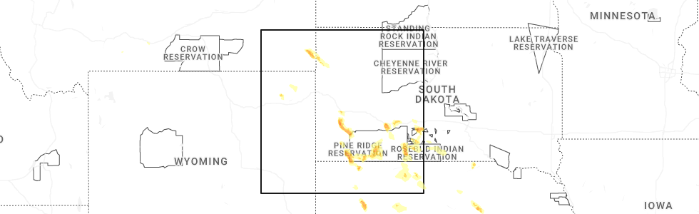
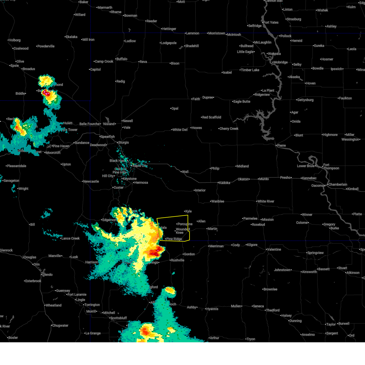
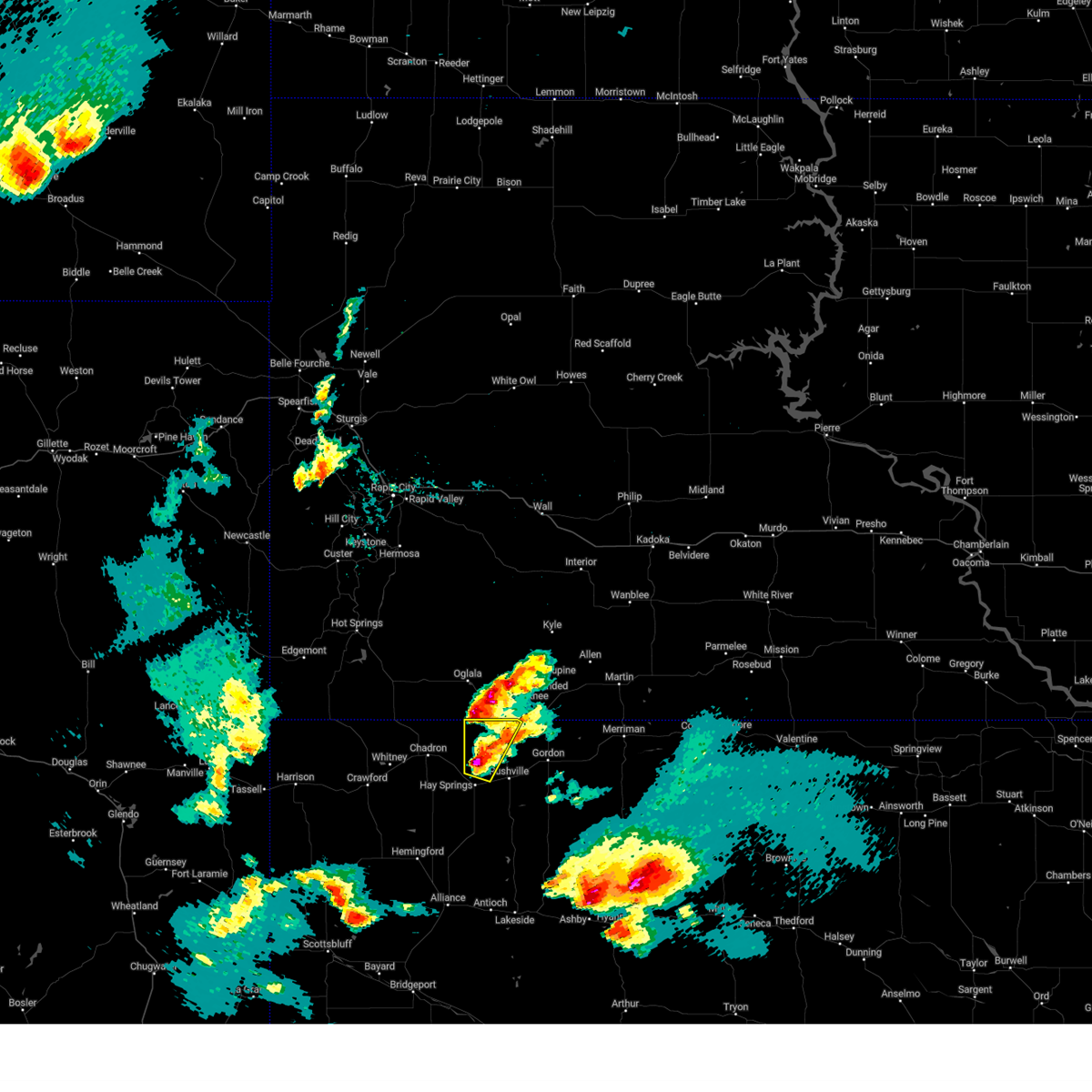
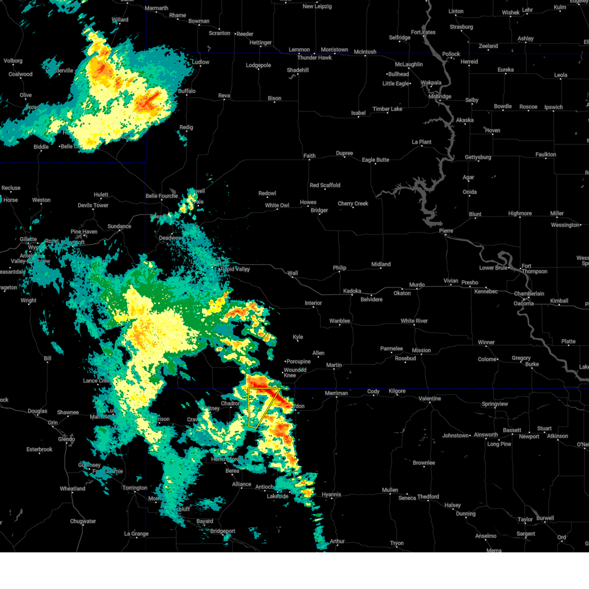
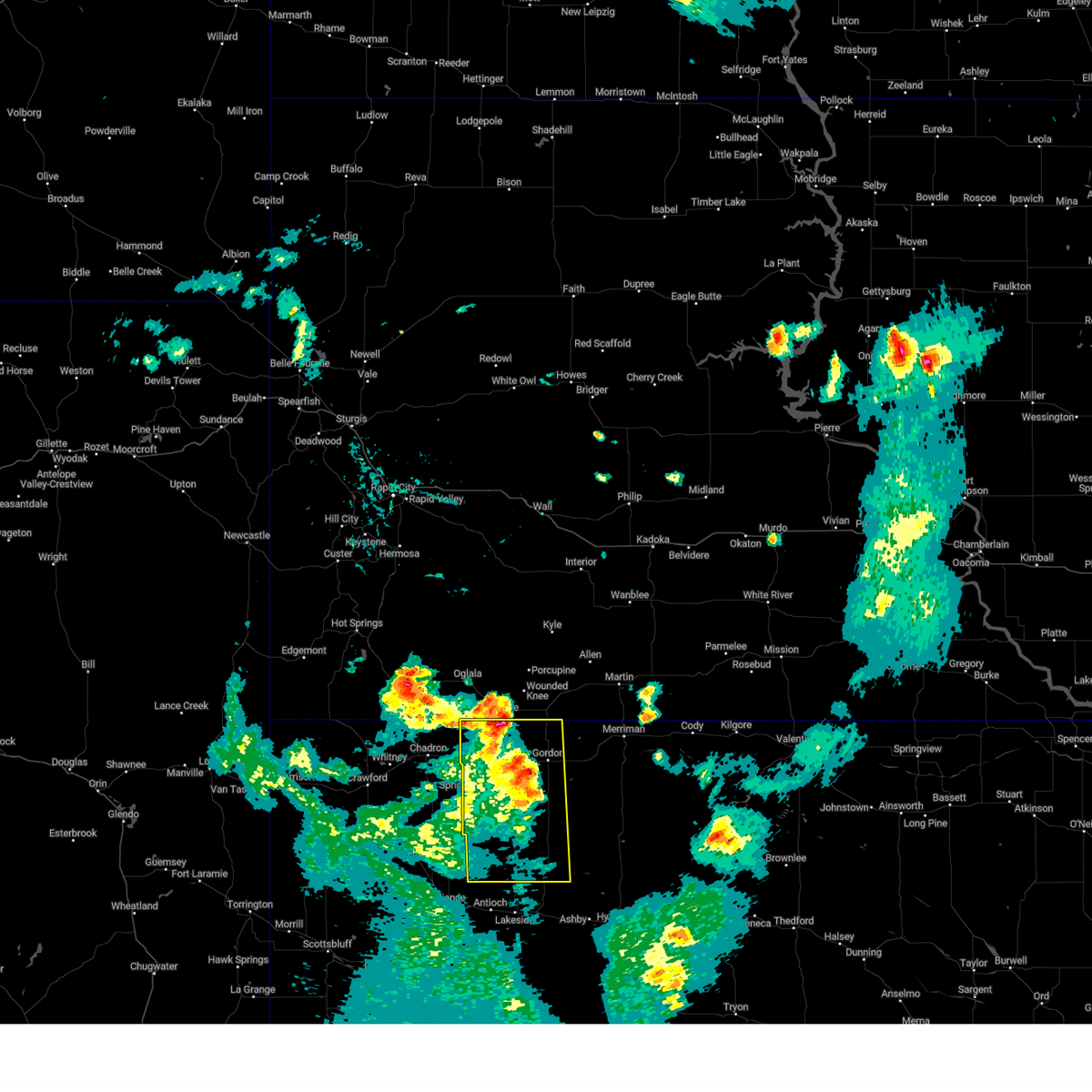
Hail Map for White Clay, SD
The White Clay, SD area has had 0 reports of on-the-ground hail by trained spotters, and has been under severe weather warnings 23 times during the past 12 months. Doppler radar has detected hail at or near White Clay, SD on 74 occasions, including 7 occasions during the past year.
| Name: | White Clay, SD |
| Where Located: | 82.2 miles SSE of Rapid City, SD |
| Map: | Google Map for White Clay, SD |
| Population: | 10 |
| Housing Units: | 4 |
| More Info: | Search Google for White Clay, SD |
1
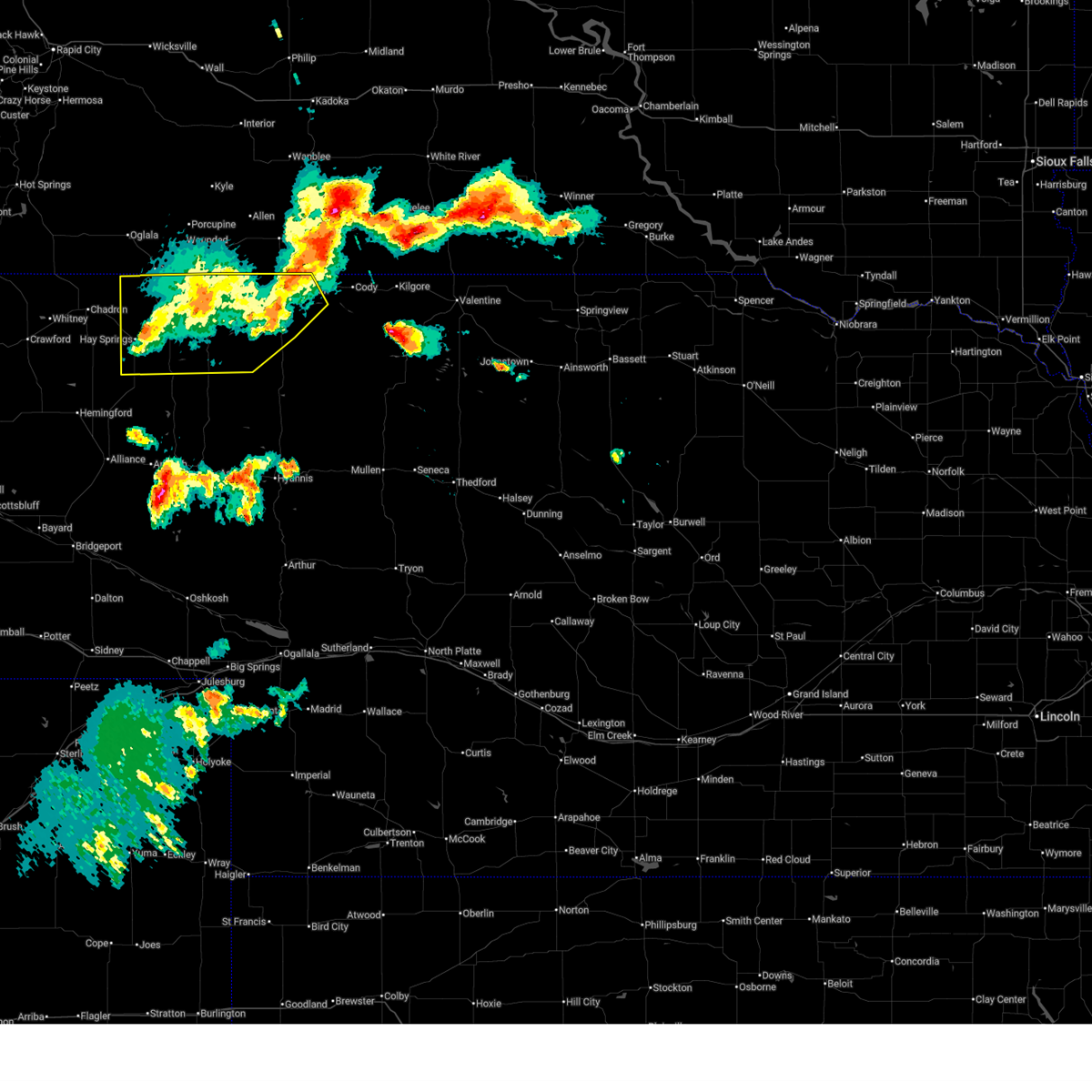
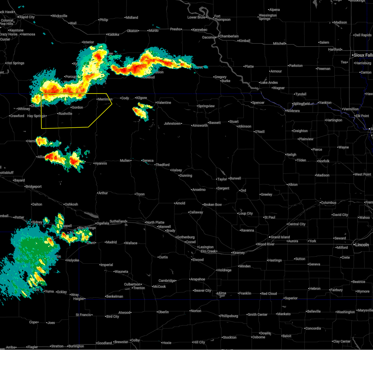
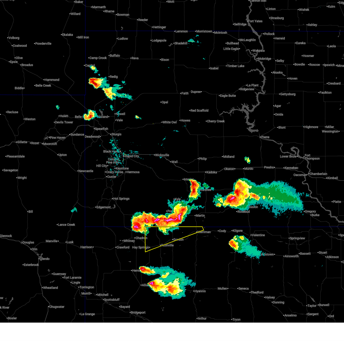
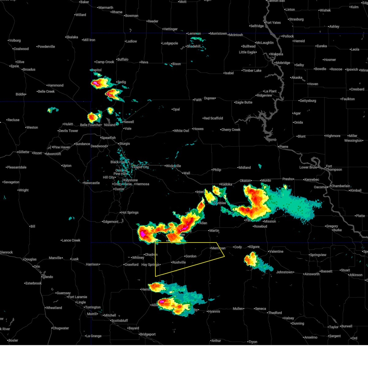
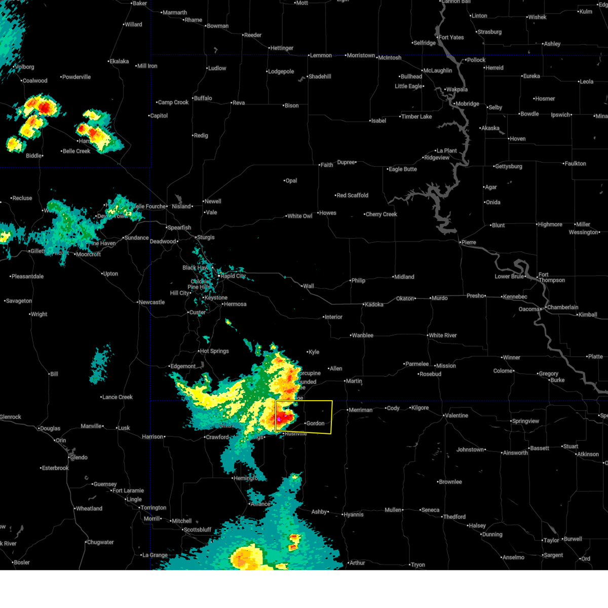
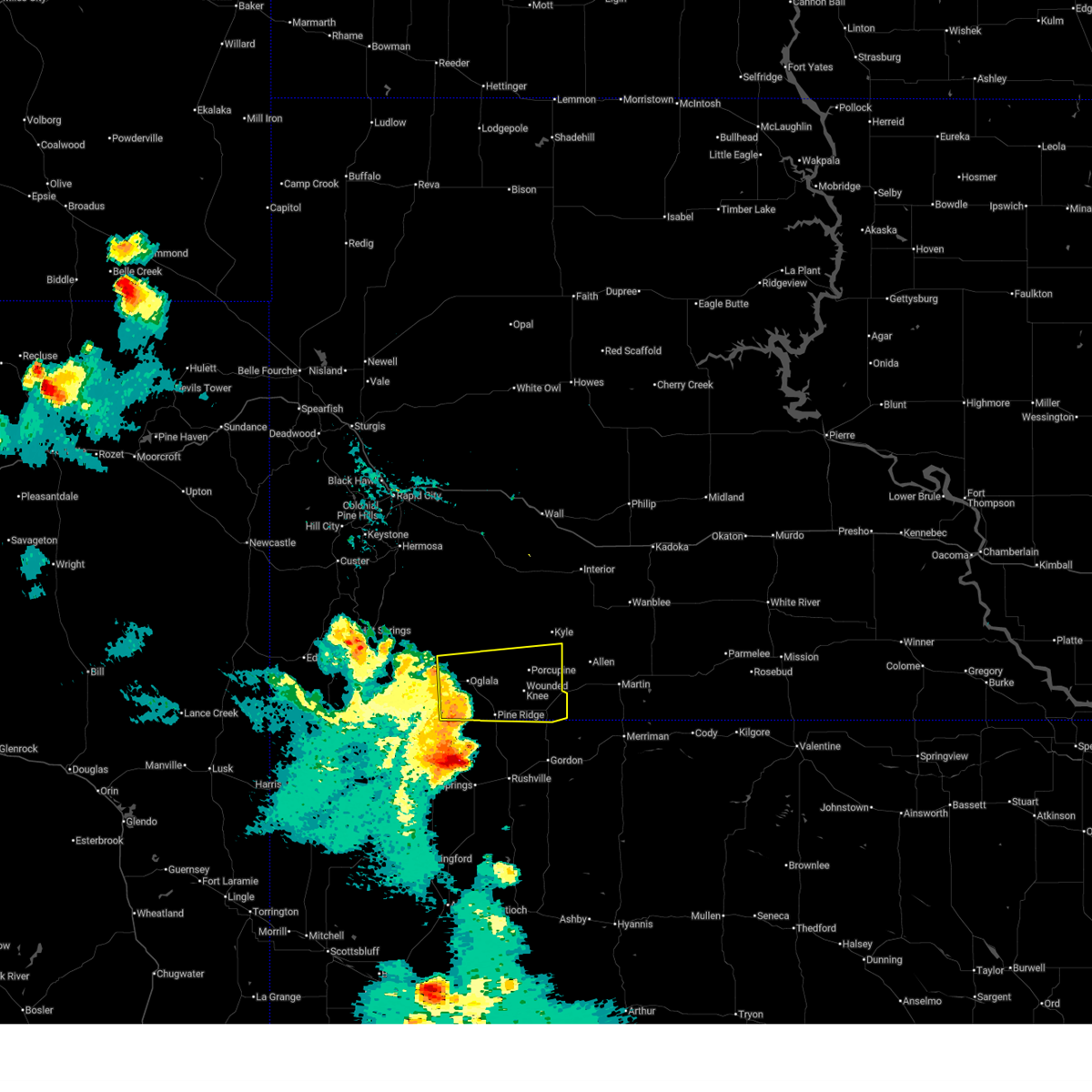
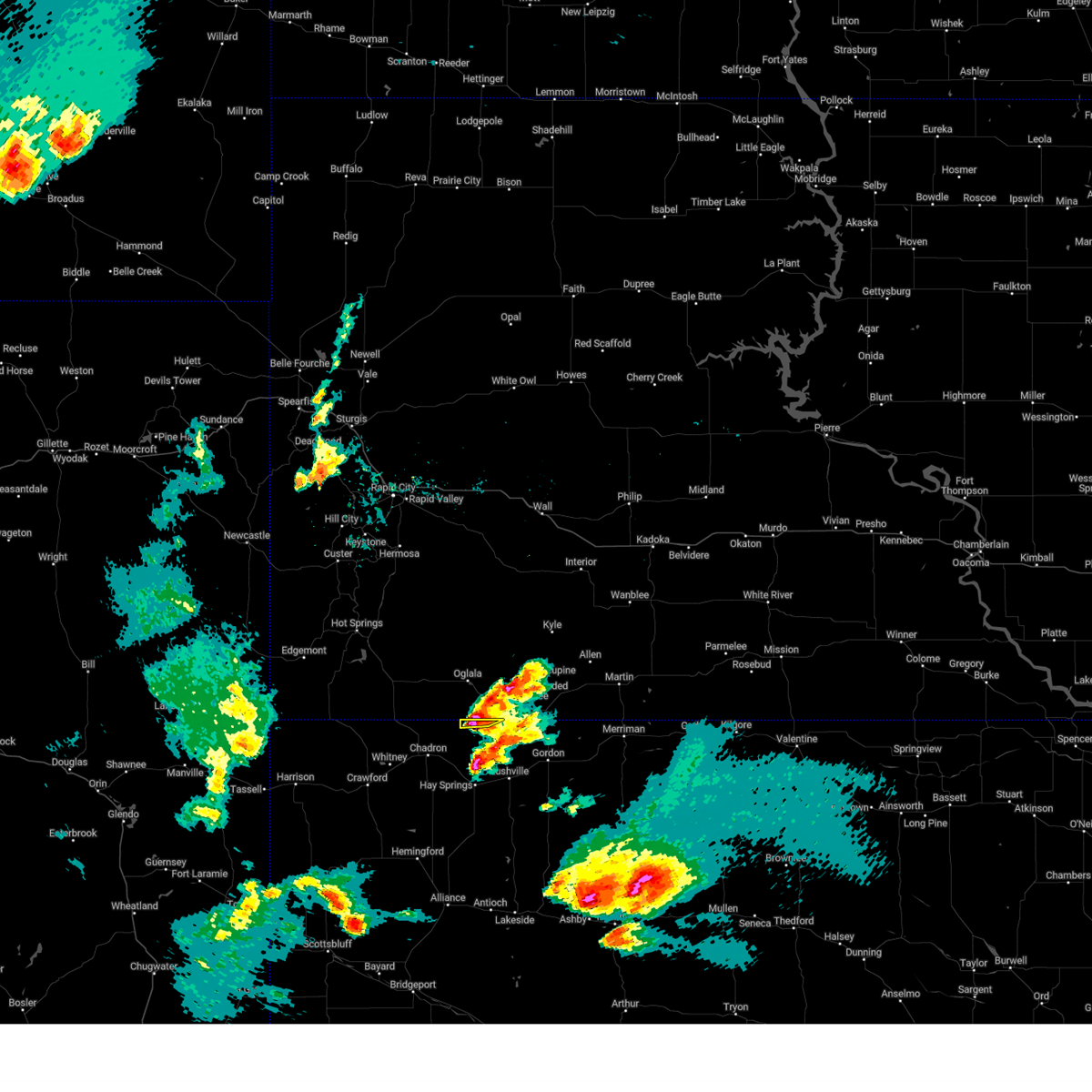
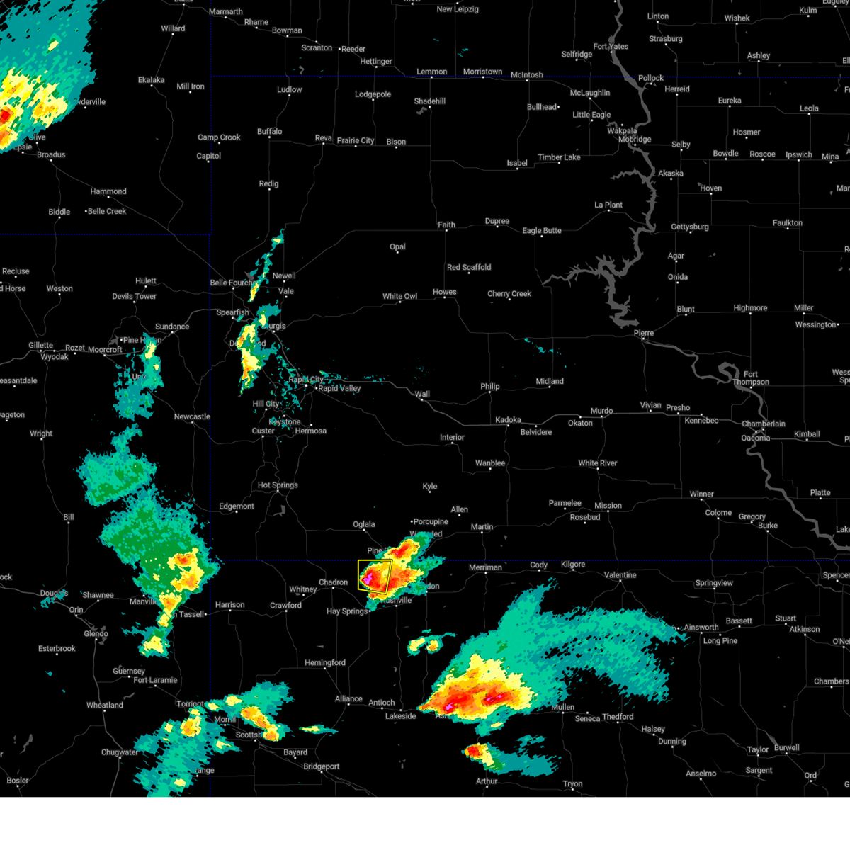
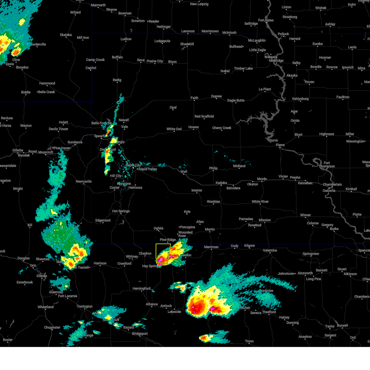
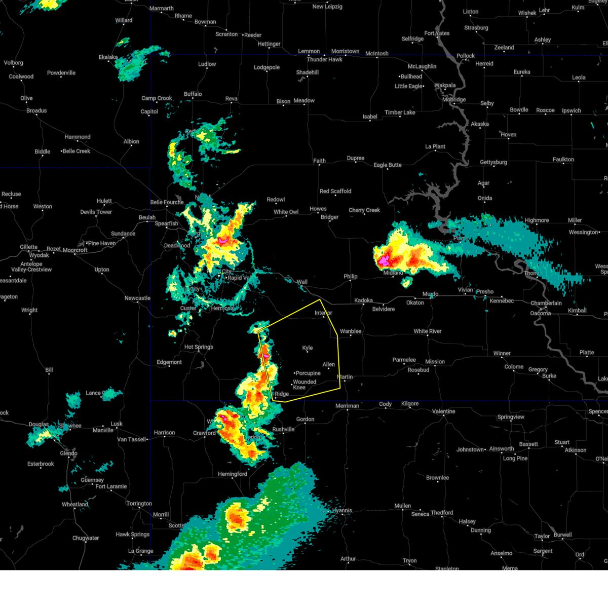
The Top Recent Hail Date for White Clay, SD is Tuesday, July 1, 2025 (14th out of 74)
Hail and Wind Damage Spotted near White Clay, SD
| Date / Time | Report Details |
|---|---|
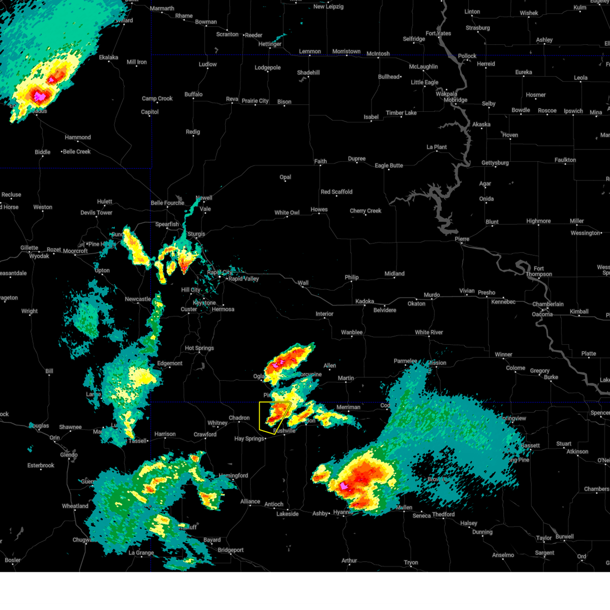
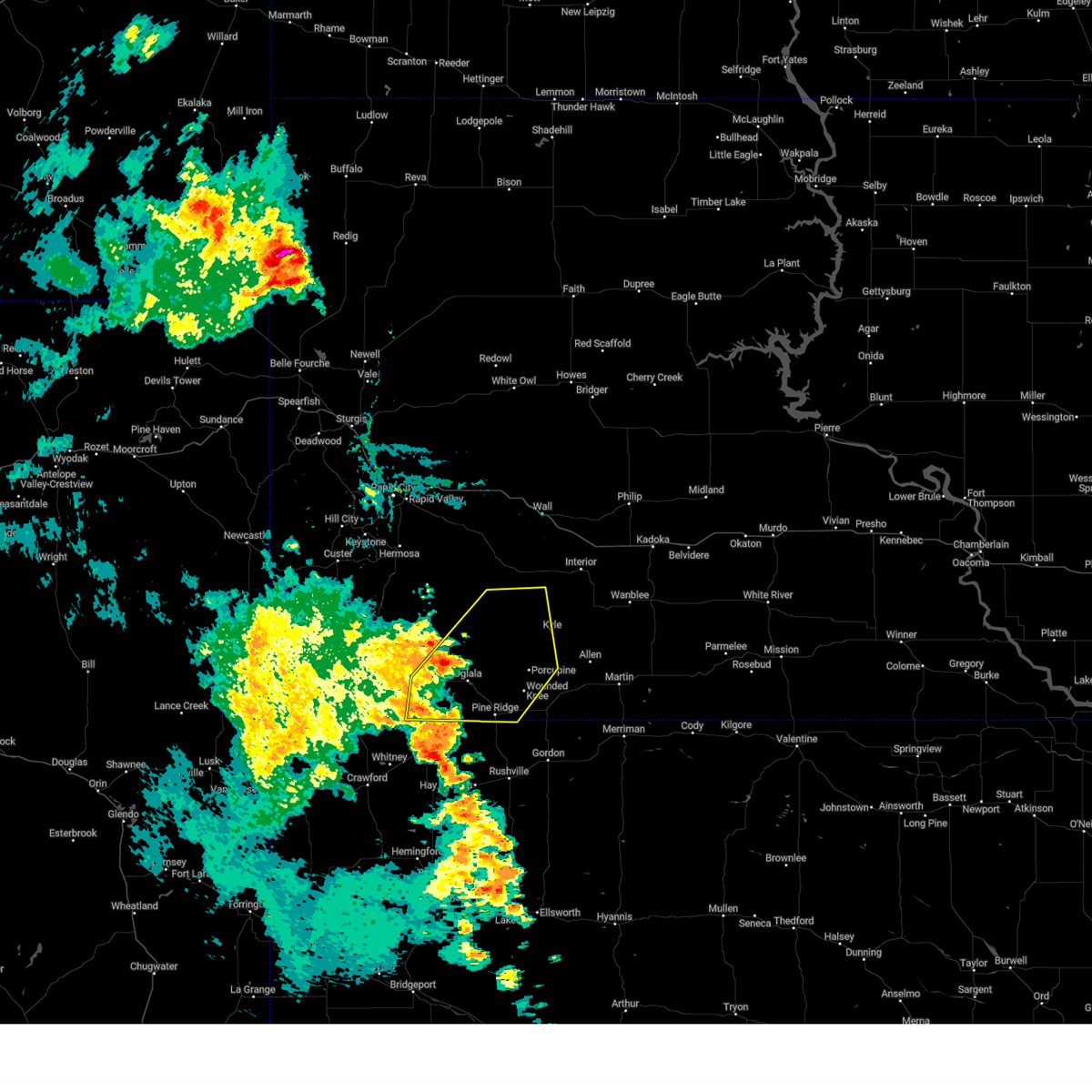
| 7/1/2025 8:12 PM MDT |
 The storms which prompted the warning have weakened below severe limits, and no longer pose an immediate threat to life or property. therefore, the warning will be allowed to expire. a severe thunderstorm watch remains in effect until 1100 pm mdt for the panhandle of and north central nebraska. The storms which prompted the warning have weakened below severe limits, and no longer pose an immediate threat to life or property. therefore, the warning will be allowed to expire. a severe thunderstorm watch remains in effect until 1100 pm mdt for the panhandle of and north central nebraska.
|
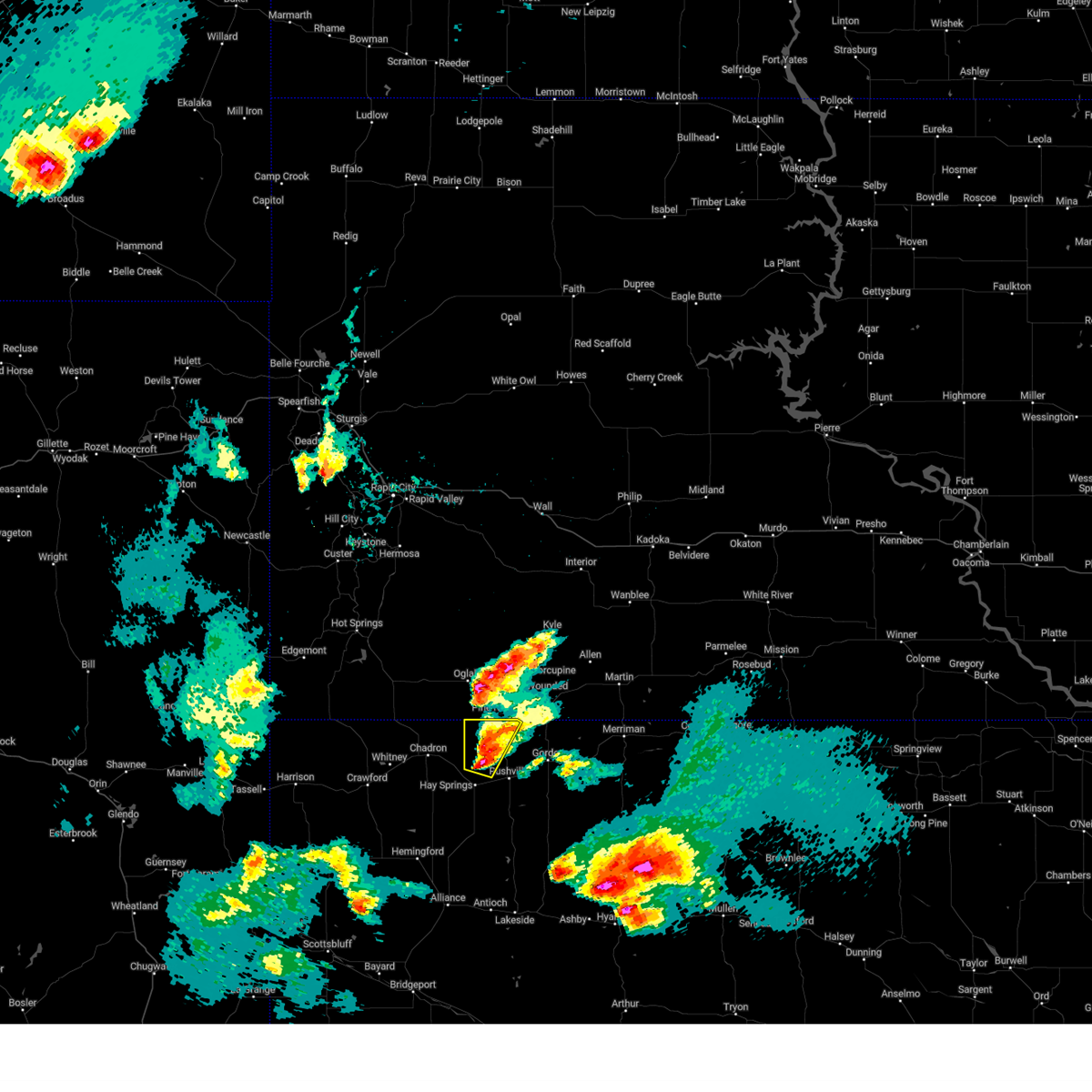
| 7/1/2025 7:56 PM MDT |
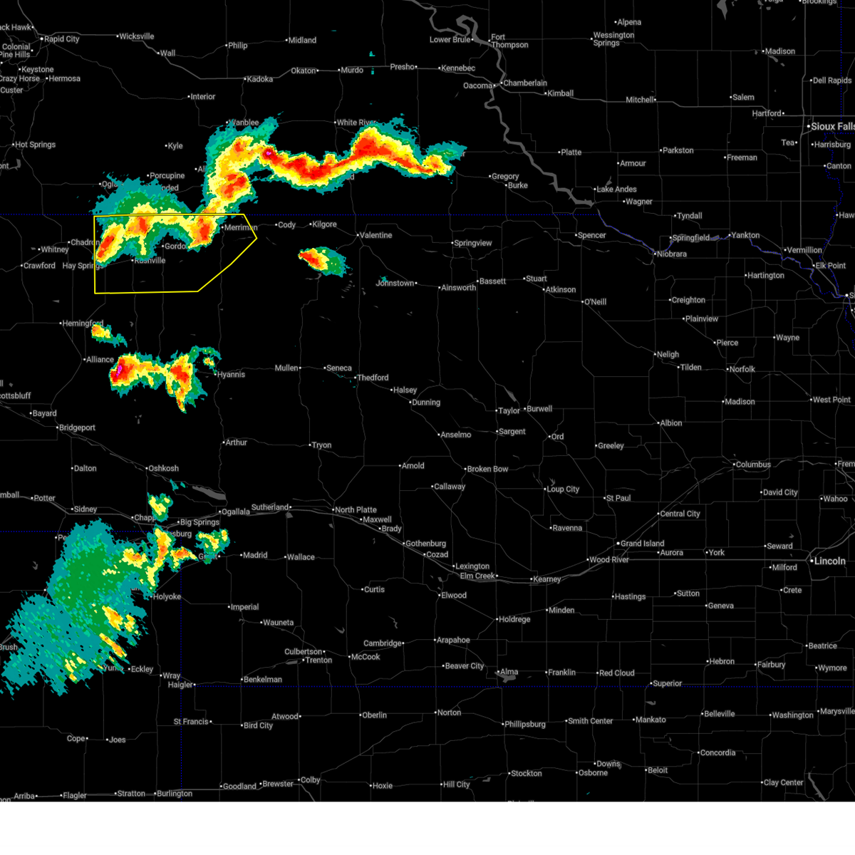 At 755 pm mdt, severe thunderstorms were located along a line extending from lacreek wildlife refuge to 14 miles east of gordon to near hay springs, moving southeast at 25 mph (radar indicated). Hazards include 60 mph wind gusts and quarter size hail. Hail damage to vehicles is expected. expect wind damage to roofs, siding, and trees. locations impacted include, gordon, rushville, hay springs, merriman, clinton, intersection of highway 87 and craven creek road, lone butte, irwin, intersection of beaver creek road and white clay creek road, intersection of highway 87 and larabee road, rock hill, pine ridge, hoover lake, metcalf state wildlife management area, highway 27 crossing the niobrara river, mount maria, intersection of highway 20 and irwin road, highway 250 crossing the niobrara river, walgren lake state recreation area, and shell lake state wildlife management area. this includes the following highways, highway 20 between mile markers 74 and 148. highway 250 between mile markers 34 and 48. Highway 61 between mile markers 205 and 231. At 755 pm mdt, severe thunderstorms were located along a line extending from lacreek wildlife refuge to 14 miles east of gordon to near hay springs, moving southeast at 25 mph (radar indicated). Hazards include 60 mph wind gusts and quarter size hail. Hail damage to vehicles is expected. expect wind damage to roofs, siding, and trees. locations impacted include, gordon, rushville, hay springs, merriman, clinton, intersection of highway 87 and craven creek road, lone butte, irwin, intersection of beaver creek road and white clay creek road, intersection of highway 87 and larabee road, rock hill, pine ridge, hoover lake, metcalf state wildlife management area, highway 27 crossing the niobrara river, mount maria, intersection of highway 20 and irwin road, highway 250 crossing the niobrara river, walgren lake state recreation area, and shell lake state wildlife management area. this includes the following highways, highway 20 between mile markers 74 and 148. highway 250 between mile markers 34 and 48. Highway 61 between mile markers 205 and 231.
|
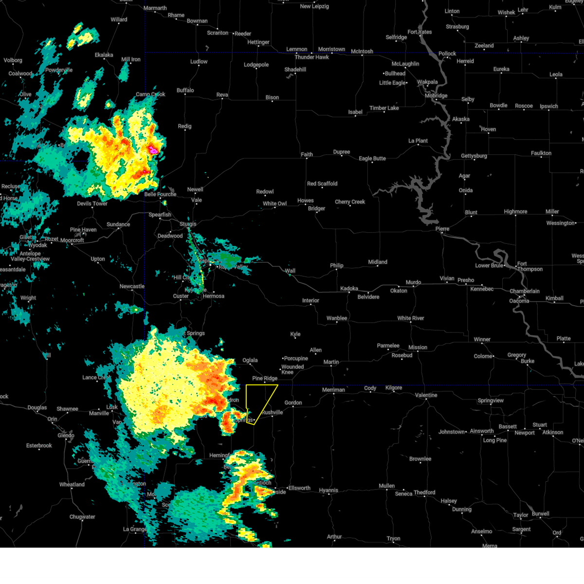
| 7/1/2025 7:25 PM MDT |
 Svrlbf the national weather service in north platte has issued a * severe thunderstorm warning for, northwestern cherry county in north central nebraska, northern sheridan county in the panhandle of nebraska, * until 815 pm mdt. * at 725 pm mdt, severe thunderstorms were located along a line extending from near lacreek north housing to 8 miles southeast of wakpamni to 10 miles northeast of chadron, moving south at 30 mph (radar indicated). Hazards include 70 mph wind gusts and half dollar size hail. Hail damage to vehicles is expected. expect considerable tree damage. Wind damage is also likely to mobile homes, roofs, and outbuildings. Svrlbf the national weather service in north platte has issued a * severe thunderstorm warning for, northwestern cherry county in north central nebraska, northern sheridan county in the panhandle of nebraska, * until 815 pm mdt. * at 725 pm mdt, severe thunderstorms were located along a line extending from near lacreek north housing to 8 miles southeast of wakpamni to 10 miles northeast of chadron, moving south at 30 mph (radar indicated). Hazards include 70 mph wind gusts and half dollar size hail. Hail damage to vehicles is expected. expect considerable tree damage. Wind damage is also likely to mobile homes, roofs, and outbuildings.
|
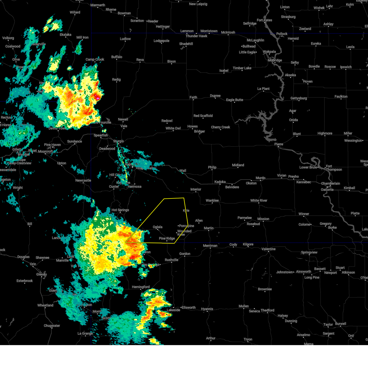
| 7/1/2025 7:10 PM MDT |
 At 709 pm mdt, severe thunderstorms were located along a line extending from near swett to 8 miles south of slim butte, moving south at 20 mph (radar indicated). Hazards include 70 mph wind gusts and ping pong ball size hail. People and animals outdoors will be injured. expect hail damage to roofs, siding, windows, and vehicles. expect considerable tree damage. wind damage is also likely to mobile homes, roofs, and outbuildings. locations impacted include, gordon, rushville, hay springs, merriman, white clay, clinton, intersection of highway 87 and craven creek road, irwin, intersection of beaver creek road and white clay creek road, intersection of highway 87 and larabee road, mount maria, shell lake state wildlife management area, pine ridge, hoover lake, and metcalf state wildlife management area. this includes the following highways, highway 20 between mile markers 74 and 111, and between mile markers 126 and 138. highway 250 near mile marker 48. Highway 61 between mile markers 226 and 231. At 709 pm mdt, severe thunderstorms were located along a line extending from near swett to 8 miles south of slim butte, moving south at 20 mph (radar indicated). Hazards include 70 mph wind gusts and ping pong ball size hail. People and animals outdoors will be injured. expect hail damage to roofs, siding, windows, and vehicles. expect considerable tree damage. wind damage is also likely to mobile homes, roofs, and outbuildings. locations impacted include, gordon, rushville, hay springs, merriman, white clay, clinton, intersection of highway 87 and craven creek road, irwin, intersection of beaver creek road and white clay creek road, intersection of highway 87 and larabee road, mount maria, shell lake state wildlife management area, pine ridge, hoover lake, and metcalf state wildlife management area. this includes the following highways, highway 20 between mile markers 74 and 111, and between mile markers 126 and 138. highway 250 near mile marker 48. Highway 61 between mile markers 226 and 231.
|
| 7/1/2025 6:49 PM MDT |
 Svrlbf the national weather service in north platte has issued a * severe thunderstorm warning for, northwestern cherry county in north central nebraska, northern sheridan county in the panhandle of nebraska, * until 730 pm mdt. * at 649 pm mdt, severe thunderstorms were located along a line extending from near yellow bear canyon to near slim butte, moving southeast at 40 mph (radar indicated). Hazards include two inch hail and 60 mph wind gusts. People and animals outdoors will be injured. expect hail damage to roofs, siding, windows, and vehicles. Expect wind damage to roofs, siding, and trees. Svrlbf the national weather service in north platte has issued a * severe thunderstorm warning for, northwestern cherry county in north central nebraska, northern sheridan county in the panhandle of nebraska, * until 730 pm mdt. * at 649 pm mdt, severe thunderstorms were located along a line extending from near yellow bear canyon to near slim butte, moving southeast at 40 mph (radar indicated). Hazards include two inch hail and 60 mph wind gusts. People and animals outdoors will be injured. expect hail damage to roofs, siding, windows, and vehicles. Expect wind damage to roofs, siding, and trees.
|
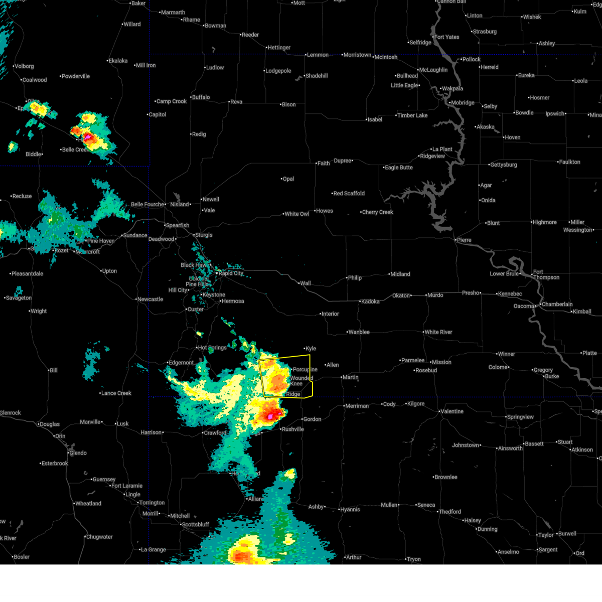
| 6/13/2025 8:14 PM MDT |
 Svrlbf the national weather service in north platte has issued a * severe thunderstorm warning for, northwestern cherry county in north central nebraska, northeastern sheridan county in the panhandle of nebraska, * until 900 pm mdt. * at 814 pm mdt, a severe thunderstorm was located 9 miles north of rushville, moving east at 25 mph (radar indicated). Hazards include 60 mph wind gusts and quarter size hail. Hail damage to vehicles is expected. Expect wind damage to roofs, siding, and trees. Svrlbf the national weather service in north platte has issued a * severe thunderstorm warning for, northwestern cherry county in north central nebraska, northeastern sheridan county in the panhandle of nebraska, * until 900 pm mdt. * at 814 pm mdt, a severe thunderstorm was located 9 miles north of rushville, moving east at 25 mph (radar indicated). Hazards include 60 mph wind gusts and quarter size hail. Hail damage to vehicles is expected. Expect wind damage to roofs, siding, and trees.
|
| 6/13/2025 8:10 PM MDT |
 The storms which prompted the warning have weakened below severe limits, and no longer pose an immediate threat to life or property. therefore, the warning will be allowed to expire. however, gusty winds are still possible with these thunderstorms. The storms which prompted the warning have weakened below severe limits, and no longer pose an immediate threat to life or property. therefore, the warning will be allowed to expire. however, gusty winds are still possible with these thunderstorms.
|
| 6/13/2025 7:44 PM MDT |
 At 744 pm mdt, severe thunderstorms were located along a line extending from 5 miles southwest of goose neck housing to 2 miles east of pine ridge, moving east at 40 mph (radar indicated). Hazards include 60 mph wind gusts. Expect damage to roofs, siding, and trees. Locations impacted include, porcupine, manderson, wounded knee, evergreen, porcupine butte housing, wolf creek housing, wakpamni and batesland. At 744 pm mdt, severe thunderstorms were located along a line extending from 5 miles southwest of goose neck housing to 2 miles east of pine ridge, moving east at 40 mph (radar indicated). Hazards include 60 mph wind gusts. Expect damage to roofs, siding, and trees. Locations impacted include, porcupine, manderson, wounded knee, evergreen, porcupine butte housing, wolf creek housing, wakpamni and batesland.
|
| 6/13/2025 7:28 PM MDT |
 Svrunr the national weather service in rapid city has issued a * severe thunderstorm warning for, southern oglala lakota county in southwestern south dakota, * until 815 pm mdt. * at 728 pm mdt, a severe thunderstorm was located 4 miles southwest of number 4, or 7 miles northwest of pine ridge, moving east at 40 mph (radar indicated). Hazards include 60 mph wind gusts. Expect damage to roofs, siding, and trees. this severe thunderstorm will be near, pine ridge, manderson, wounded knee, calico, number 4, and wolf creek housing around 735 pm mdt. porcupine butte housing around 740 pm mdt. porcupine around 745 pm mdt. Other locations in the path of this severe thunderstorm include batesland and wakpamni. Svrunr the national weather service in rapid city has issued a * severe thunderstorm warning for, southern oglala lakota county in southwestern south dakota, * until 815 pm mdt. * at 728 pm mdt, a severe thunderstorm was located 4 miles southwest of number 4, or 7 miles northwest of pine ridge, moving east at 40 mph (radar indicated). Hazards include 60 mph wind gusts. Expect damage to roofs, siding, and trees. this severe thunderstorm will be near, pine ridge, manderson, wounded knee, calico, number 4, and wolf creek housing around 735 pm mdt. porcupine butte housing around 740 pm mdt. porcupine around 745 pm mdt. Other locations in the path of this severe thunderstorm include batesland and wakpamni.
|
| 4/27/2025 7:25 PM MDT |
 The storm which prompted the warning has weakened below severe limits, and no longer poses an immediate threat to life or property. therefore, the warning will be allowed to expire. a tornado watch remains in effect until 1100 pm mdt for the panhandle of nebraska. The storm which prompted the warning has weakened below severe limits, and no longer poses an immediate threat to life or property. therefore, the warning will be allowed to expire. a tornado watch remains in effect until 1100 pm mdt for the panhandle of nebraska.
|
| 4/27/2025 7:08 PM MDT |
 At 707 pm mdt, a severe thunderstorm was located 8 miles north of hay springs, moving north at 10 mph (radar indicated). Hazards include ping pong ball size hail and 60 mph wind gusts. People and animals outdoors will be injured. expect hail damage to roofs, siding, windows, and vehicles. expect wind damage to roofs, siding, and trees. Locations impacted include, white clay, pine ridge, intersection of highway 87 and craven creek road, intersection of highway 87 and larabee road, mount maria, and metcalf state wildlife management area. At 707 pm mdt, a severe thunderstorm was located 8 miles north of hay springs, moving north at 10 mph (radar indicated). Hazards include ping pong ball size hail and 60 mph wind gusts. People and animals outdoors will be injured. expect hail damage to roofs, siding, windows, and vehicles. expect wind damage to roofs, siding, and trees. Locations impacted include, white clay, pine ridge, intersection of highway 87 and craven creek road, intersection of highway 87 and larabee road, mount maria, and metcalf state wildlife management area.
|
| 4/27/2025 6:49 PM MDT |
 Svrlbf the national weather service in north platte has issued a * severe thunderstorm warning for, northwestern sheridan county in the panhandle of nebraska, * until 730 pm mdt. * at 649 pm mdt, a severe thunderstorm was located 7 miles north of hay springs, moving north at 15 mph (radar indicated). Hazards include golf ball size hail and 60 mph wind gusts. People and animals outdoors will be injured. expect hail damage to roofs, siding, windows, and vehicles. Expect wind damage to roofs, siding, and trees. Svrlbf the national weather service in north platte has issued a * severe thunderstorm warning for, northwestern sheridan county in the panhandle of nebraska, * until 730 pm mdt. * at 649 pm mdt, a severe thunderstorm was located 7 miles north of hay springs, moving north at 15 mph (radar indicated). Hazards include golf ball size hail and 60 mph wind gusts. People and animals outdoors will be injured. expect hail damage to roofs, siding, windows, and vehicles. Expect wind damage to roofs, siding, and trees.
|
| 4/27/2025 6:48 PM MDT |
 At 648 pm mdt, a severe thunderstorm was located near white clay, or near pine ridge, moving northeast at 25 mph (radar indicated). Hazards include 60 mph wind gusts and quarter size hail. Hail damage to vehicles is expected. expect wind damage to roofs, siding, and trees. Locations impacted include, white clay and pine ridge. At 648 pm mdt, a severe thunderstorm was located near white clay, or near pine ridge, moving northeast at 25 mph (radar indicated). Hazards include 60 mph wind gusts and quarter size hail. Hail damage to vehicles is expected. expect wind damage to roofs, siding, and trees. Locations impacted include, white clay and pine ridge.
|
| 4/27/2025 6:31 PM MDT |
 At 631 pm mdt, a severe thunderstorm was located 9 miles southwest of white clay, or 10 miles southwest of pine ridge, moving north at 30 mph (radar indicated). Hazards include golf ball size hail and 60 mph wind gusts. People and animals outdoors will be injured. expect hail damage to roofs, siding, windows, and vehicles. expect wind damage to roofs, siding, and trees. Locations impacted include, white clay, pine ridge, intersection of highway 87 and craven creek road, intersection of highway 87 and larabee road, and metcalf state wildlife management area. At 631 pm mdt, a severe thunderstorm was located 9 miles southwest of white clay, or 10 miles southwest of pine ridge, moving north at 30 mph (radar indicated). Hazards include golf ball size hail and 60 mph wind gusts. People and animals outdoors will be injured. expect hail damage to roofs, siding, windows, and vehicles. expect wind damage to roofs, siding, and trees. Locations impacted include, white clay, pine ridge, intersection of highway 87 and craven creek road, intersection of highway 87 and larabee road, and metcalf state wildlife management area.
|
| 4/27/2025 6:17 PM MDT |
 Svrlbf the national weather service in north platte has issued a * severe thunderstorm warning for, northwestern sheridan county in the panhandle of nebraska, * until 700 pm mdt. * at 617 pm mdt, a severe thunderstorm was located 8 miles north of hay springs, moving northeast at 25 mph (radar indicated). Hazards include two inch hail and 60 mph wind gusts. People and animals outdoors will be injured. expect hail damage to roofs, siding, windows, and vehicles. Expect wind damage to roofs, siding, and trees. Svrlbf the national weather service in north platte has issued a * severe thunderstorm warning for, northwestern sheridan county in the panhandle of nebraska, * until 700 pm mdt. * at 617 pm mdt, a severe thunderstorm was located 8 miles north of hay springs, moving northeast at 25 mph (radar indicated). Hazards include two inch hail and 60 mph wind gusts. People and animals outdoors will be injured. expect hail damage to roofs, siding, windows, and vehicles. Expect wind damage to roofs, siding, and trees.
|
| 9/17/2024 7:26 PM MDT |
 The storm which prompted the warning has moved out of the area. therefore, the warning will be allowed to expire. a severe thunderstorm watch remains in effect until 900 pm mdt for the panhandle of nebraska. to report severe weather, contact your nearest law enforcement agency. they will relay your report to the national weather service north platte. The storm which prompted the warning has moved out of the area. therefore, the warning will be allowed to expire. a severe thunderstorm watch remains in effect until 900 pm mdt for the panhandle of nebraska. to report severe weather, contact your nearest law enforcement agency. they will relay your report to the national weather service north platte.
|
| 9/17/2024 6:59 PM MDT |
 At 658 pm mdt, severe thunderstorms were located along a line extending from 6 miles southeast of intersection of red shirt and cuny table roads to 2 miles northeast of oglala to 2 miles southeast of slim buttes housing, moving northeast at 55 mph. automated observations on the fall river and oglala lakota county line recently recorded wind gusts over 60 mph (automated observations indicated). Hazards include 60 mph wind gusts. Expect damage to roofs, siding, and trees. Locations impacted include, pine ridge, oglala, porcupine, kyle, manderson, wounded knee, lonesome valley, loneman, goose neck housing, south lakeside, rockyford, sharps corner, number 4, kyle north route housing, wolf creek housing, dry wood housing, prairie winds casino, thunder valley, calico, and evergreen. At 658 pm mdt, severe thunderstorms were located along a line extending from 6 miles southeast of intersection of red shirt and cuny table roads to 2 miles northeast of oglala to 2 miles southeast of slim buttes housing, moving northeast at 55 mph. automated observations on the fall river and oglala lakota county line recently recorded wind gusts over 60 mph (automated observations indicated). Hazards include 60 mph wind gusts. Expect damage to roofs, siding, and trees. Locations impacted include, pine ridge, oglala, porcupine, kyle, manderson, wounded knee, lonesome valley, loneman, goose neck housing, south lakeside, rockyford, sharps corner, number 4, kyle north route housing, wolf creek housing, dry wood housing, prairie winds casino, thunder valley, calico, and evergreen.
|
| 9/17/2024 6:39 PM MDT |
 Svrlbf the national weather service in north platte has issued a * severe thunderstorm warning for, northwestern sheridan county in the panhandle of nebraska, * until 730 pm mdt. * at 638 pm mdt, a severe thunderstorm was located over chadron, moving northeast at 50 mph (radar indicated). Hazards include 70 mph wind gusts. Expect considerable tree damage. Damage is likely to mobile homes, roofs, and outbuildings. Svrlbf the national weather service in north platte has issued a * severe thunderstorm warning for, northwestern sheridan county in the panhandle of nebraska, * until 730 pm mdt. * at 638 pm mdt, a severe thunderstorm was located over chadron, moving northeast at 50 mph (radar indicated). Hazards include 70 mph wind gusts. Expect considerable tree damage. Damage is likely to mobile homes, roofs, and outbuildings.
|
| 9/17/2024 6:33 PM MDT |
 Svrunr the national weather service in rapid city has issued a * severe thunderstorm warning for, oglala lakota county in southwestern south dakota, southeastern fall river county in southwestern south dakota, * until 730 pm mdt. * at 633 pm mdt, severe thunderstorms were located along a line extending from 3 miles west of prairie winds casino to 7 miles south of slim butte to chadron, moving northeast at 55 mph (radar indicated). Hazards include 60 mph wind gusts. Expect damage to roofs, siding, and trees. severe thunderstorms will be near, oglala, loneman, dry wood housing, number 4, south lakeside, prairie winds casino, slim buttes housing, and slim butte around 640 pm mdt. calico around 645 pm mdt. pine ridge around 650 pm mdt. Other locations in the path of these severe thunderstorms include manderson, lonesome valley, southern badlands national park, goose neck housing, rockyford, wounded knee, evergreen, thunder valley, sharps corner, porcupine and porcupine butte housing. Svrunr the national weather service in rapid city has issued a * severe thunderstorm warning for, oglala lakota county in southwestern south dakota, southeastern fall river county in southwestern south dakota, * until 730 pm mdt. * at 633 pm mdt, severe thunderstorms were located along a line extending from 3 miles west of prairie winds casino to 7 miles south of slim butte to chadron, moving northeast at 55 mph (radar indicated). Hazards include 60 mph wind gusts. Expect damage to roofs, siding, and trees. severe thunderstorms will be near, oglala, loneman, dry wood housing, number 4, south lakeside, prairie winds casino, slim buttes housing, and slim butte around 640 pm mdt. calico around 645 pm mdt. pine ridge around 650 pm mdt. Other locations in the path of these severe thunderstorms include manderson, lonesome valley, southern badlands national park, goose neck housing, rockyford, wounded knee, evergreen, thunder valley, sharps corner, porcupine and porcupine butte housing.
|
| 8/21/2024 6:30 PM MDT |
 Svrunr the national weather service in rapid city has issued a * severe thunderstorm warning for, oglala lakota county in southwestern south dakota, southwestern jackson county in southwestern south dakota, western bennett county in southwestern south dakota, southeastern pennington county in west central south dakota, * until 730 pm mdt. * at 630 pm mdt, severe thunderstorms were located along a line extending from badlands national park to near goose neck housing to near wolf creek housing, moving northeast at 40 mph (radar indicated). Hazards include 60 mph wind gusts and quarter size hail. Hail damage to vehicles is expected. expect wind damage to roofs, siding, and trees. severe thunderstorms will be near, porcupine, manderson, wounded knee, wolf creek housing, thunder valley, porcupine butte housing, rockyford, sharps corner, evergreen, and goose neck housing around 635 pm mdt. kyle around 640 pm mdt. batesland and yellow bear canyon around 645 pm mdt. Other locations in the path of these severe thunderstorms include potato creek, swett, allen, snake butte, interior and cedar pass. Svrunr the national weather service in rapid city has issued a * severe thunderstorm warning for, oglala lakota county in southwestern south dakota, southwestern jackson county in southwestern south dakota, western bennett county in southwestern south dakota, southeastern pennington county in west central south dakota, * until 730 pm mdt. * at 630 pm mdt, severe thunderstorms were located along a line extending from badlands national park to near goose neck housing to near wolf creek housing, moving northeast at 40 mph (radar indicated). Hazards include 60 mph wind gusts and quarter size hail. Hail damage to vehicles is expected. expect wind damage to roofs, siding, and trees. severe thunderstorms will be near, porcupine, manderson, wounded knee, wolf creek housing, thunder valley, porcupine butte housing, rockyford, sharps corner, evergreen, and goose neck housing around 635 pm mdt. kyle around 640 pm mdt. batesland and yellow bear canyon around 645 pm mdt. Other locations in the path of these severe thunderstorms include potato creek, swett, allen, snake butte, interior and cedar pass.
|
| 7/27/2024 8:11 PM MDT |
 The storms which prompted the warning have weakened below severe limits, and no longer pose an immediate threat to life or property. therefore, the warning will be allowed to expire. however, gusty winds are still possible with these thunderstorms. The storms which prompted the warning have weakened below severe limits, and no longer pose an immediate threat to life or property. therefore, the warning will be allowed to expire. however, gusty winds are still possible with these thunderstorms.
|
| 7/27/2024 7:56 PM MDT |
 At 756 pm mdt, severe thunderstorms were located along a line extending from near white clay to 6 miles south of rushville to 18 miles northwest of ellsworth, moving east at 30 mph (radar indicated). Hazards include 60 mph wind gusts. Expect damage to roofs, siding, and trees. locations impacted include, gordon, rushville, hay springs, white clay, clinton, intersection of highway 87 and craven creek road, billys lake, lone butte, intersection of beaver creek road and white clay creek road, intersection of highway 87 and larabee road, highway 27 crossing the niobrara river, smith lake state wildlife management area, mount maria, highway 250 crossing the niobrara river, walgren lake state recreation area, intersection of highway 27 and mills road, pine ridge, diamond lake, metcalf state wildlife management area, and wolf hill. this includes the following highways, highway 20 between mile markers 74 and 111. Highway 250 between mile markers 13 and 48. At 756 pm mdt, severe thunderstorms were located along a line extending from near white clay to 6 miles south of rushville to 18 miles northwest of ellsworth, moving east at 30 mph (radar indicated). Hazards include 60 mph wind gusts. Expect damage to roofs, siding, and trees. locations impacted include, gordon, rushville, hay springs, white clay, clinton, intersection of highway 87 and craven creek road, billys lake, lone butte, intersection of beaver creek road and white clay creek road, intersection of highway 87 and larabee road, highway 27 crossing the niobrara river, smith lake state wildlife management area, mount maria, highway 250 crossing the niobrara river, walgren lake state recreation area, intersection of highway 27 and mills road, pine ridge, diamond lake, metcalf state wildlife management area, and wolf hill. this includes the following highways, highway 20 between mile markers 74 and 111. Highway 250 between mile markers 13 and 48.
|
| 7/27/2024 7:29 PM MDT |
 Svrlbf the national weather service in north platte has issued a * severe thunderstorm warning for, sheridan county in the panhandle of nebraska, * until 815 pm mdt. * at 728 pm mdt, severe thunderstorms were located along a line extending from near chadron to 8 miles south of hay springs to near wild horse butte, moving east at 50 mph (radar indicated). Hazards include 60 mph wind gusts. expect damage to roofs, siding, and trees Svrlbf the national weather service in north platte has issued a * severe thunderstorm warning for, sheridan county in the panhandle of nebraska, * until 815 pm mdt. * at 728 pm mdt, severe thunderstorms were located along a line extending from near chadron to 8 miles south of hay springs to near wild horse butte, moving east at 50 mph (radar indicated). Hazards include 60 mph wind gusts. expect damage to roofs, siding, and trees
|
| 7/1/2024 3:29 PM MDT |
 The storm which prompted the warning has weakened below severe limits, and no longer poses an immediate threat to life or property. therefore, the warning will be allowed to expire. however, gusty winds are still possible with this thunderstorm. a severe thunderstorm watch remains in effect until 800 pm mdt for the panhandle of nebraska. to report severe weather, contact your nearest law enforcement agency. they will relay your report to the national weather service north platte. The storm which prompted the warning has weakened below severe limits, and no longer poses an immediate threat to life or property. therefore, the warning will be allowed to expire. however, gusty winds are still possible with this thunderstorm. a severe thunderstorm watch remains in effect until 800 pm mdt for the panhandle of nebraska. to report severe weather, contact your nearest law enforcement agency. they will relay your report to the national weather service north platte.
|
| 7/1/2024 3:08 PM MDT |
 At 304 pm mdt, a severe thunderstorm was located near slim buttes housing, or 9 miles west of pine ridge, moving east at 35 mph near the state line (radar indicated). Hazards include 60 mph wind gusts and quarter size hail. Hail damage to vehicles is expected. expect wind damage to roofs, siding, and trees. locations impacted include, gordon, white clay, clinton, pine ridge, intersection of highway 87 and craven creek road, metcalf state wildlife management area, lone butte, intersection of highway 87 and larabee road, mount maria, and intersection of highway 27 and mills road. This includes highway 20 between mile markers 92 and 106. At 304 pm mdt, a severe thunderstorm was located near slim buttes housing, or 9 miles west of pine ridge, moving east at 35 mph near the state line (radar indicated). Hazards include 60 mph wind gusts and quarter size hail. Hail damage to vehicles is expected. expect wind damage to roofs, siding, and trees. locations impacted include, gordon, white clay, clinton, pine ridge, intersection of highway 87 and craven creek road, metcalf state wildlife management area, lone butte, intersection of highway 87 and larabee road, mount maria, and intersection of highway 27 and mills road. This includes highway 20 between mile markers 92 and 106.
|
| 7/1/2024 2:49 PM MDT |
 Svrlbf the national weather service in north platte has issued a * severe thunderstorm warning for, northern sheridan county in the panhandle of nebraska, * until 330 pm mdt. * at 248 pm mdt, a severe thunderstorm was located 7 miles south of slim butte, or 10 miles north of chadron, moving east at 35 mph (radar indicated). Hazards include 70 mph wind gusts and half dollar size hail. Hail damage to vehicles is expected. expect considerable tree damage. Wind damage is also likely to mobile homes, roofs, and outbuildings. Svrlbf the national weather service in north platte has issued a * severe thunderstorm warning for, northern sheridan county in the panhandle of nebraska, * until 330 pm mdt. * at 248 pm mdt, a severe thunderstorm was located 7 miles south of slim butte, or 10 miles north of chadron, moving east at 35 mph (radar indicated). Hazards include 70 mph wind gusts and half dollar size hail. Hail damage to vehicles is expected. expect considerable tree damage. Wind damage is also likely to mobile homes, roofs, and outbuildings.
|
| 6/10/2024 5:02 PM MDT |
 The storms which prompted the warning have weakened below severe limits, and no longer pose an immediate threat to life or property. therefore, the warning has been allowed to expire. however, gusty winds are still possible with these thunderstorms. a severe thunderstorm watch remains in effect until 800 pm mdt for the panhandle of nebraska. The storms which prompted the warning have weakened below severe limits, and no longer pose an immediate threat to life or property. therefore, the warning has been allowed to expire. however, gusty winds are still possible with these thunderstorms. a severe thunderstorm watch remains in effect until 800 pm mdt for the panhandle of nebraska.
|
| 6/10/2024 4:47 PM MDT |
 At 447 pm mdt, severe thunderstorms were located along a line extending from 7 miles southeast of white clay to near rushville to 12 miles northeast of wild horse butte, moving east at 35 mph (radar indicated). Hazards include 60 mph wind gusts. Expect damage to roofs, siding, and trees. locations impacted include, rushville, hay springs, white clay, clinton, intersection of highway 87 and craven creek road, intersection of beaver creek road and white clay creek road, intersection of highway 87 and larabee road, smith lake state wildlife management area, mount maria, highway 250 crossing the niobrara river, walgren lake state recreation area, pine ridge, metcalf state wildlife management area, and intersection of highway 87 and antelope road. this includes the following highways, highway 20 between mile markers 74 and 98. Highway 250 between mile markers 26 and 48. At 447 pm mdt, severe thunderstorms were located along a line extending from 7 miles southeast of white clay to near rushville to 12 miles northeast of wild horse butte, moving east at 35 mph (radar indicated). Hazards include 60 mph wind gusts. Expect damage to roofs, siding, and trees. locations impacted include, rushville, hay springs, white clay, clinton, intersection of highway 87 and craven creek road, intersection of beaver creek road and white clay creek road, intersection of highway 87 and larabee road, smith lake state wildlife management area, mount maria, highway 250 crossing the niobrara river, walgren lake state recreation area, pine ridge, metcalf state wildlife management area, and intersection of highway 87 and antelope road. this includes the following highways, highway 20 between mile markers 74 and 98. Highway 250 between mile markers 26 and 48.
|
| 6/10/2024 4:35 PM MDT |
 At 434 pm mdt, severe thunderstorms were located along a line extending from near white clay to near hay springs to 11 miles east of box butte dam, moving east at 30 mph (radar indicated). Hazards include 60 mph wind gusts and quarter size hail. Hail damage to vehicles is expected. expect wind damage to roofs, siding, and trees. locations impacted include, rushville, hay springs, white clay, clinton, intersection of highway 87 and craven creek road, intersection of beaver creek road and white clay creek road, intersection of highway 87 and larabee road, smith lake state wildlife management area, mount maria, highway 250 crossing the niobrara river, walgren lake state recreation area, pine ridge, metcalf state wildlife management area, and intersection of highway 87 and antelope road. this includes the following highways, highway 20 between mile markers 74 and 98. Highway 250 between mile markers 26 and 48. At 434 pm mdt, severe thunderstorms were located along a line extending from near white clay to near hay springs to 11 miles east of box butte dam, moving east at 30 mph (radar indicated). Hazards include 60 mph wind gusts and quarter size hail. Hail damage to vehicles is expected. expect wind damage to roofs, siding, and trees. locations impacted include, rushville, hay springs, white clay, clinton, intersection of highway 87 and craven creek road, intersection of beaver creek road and white clay creek road, intersection of highway 87 and larabee road, smith lake state wildlife management area, mount maria, highway 250 crossing the niobrara river, walgren lake state recreation area, pine ridge, metcalf state wildlife management area, and intersection of highway 87 and antelope road. this includes the following highways, highway 20 between mile markers 74 and 98. Highway 250 between mile markers 26 and 48.
|
| 6/10/2024 4:15 PM MDT |
 Svrlbf the national weather service in north platte has issued a * severe thunderstorm warning for, northwestern sheridan county in the panhandle of nebraska, * until 500 pm mdt. * at 414 pm mdt, severe thunderstorms were located along a line extending from 9 miles south of slim buttes housing to 7 miles west of hay springs to near box butte campground, moving east at 40 mph (radar indicated). Hazards include 60 mph wind gusts and quarter size hail. Hail damage to vehicles is expected. Expect wind damage to roofs, siding, and trees. Svrlbf the national weather service in north platte has issued a * severe thunderstorm warning for, northwestern sheridan county in the panhandle of nebraska, * until 500 pm mdt. * at 414 pm mdt, severe thunderstorms were located along a line extending from 9 miles south of slim buttes housing to 7 miles west of hay springs to near box butte campground, moving east at 40 mph (radar indicated). Hazards include 60 mph wind gusts and quarter size hail. Hail damage to vehicles is expected. Expect wind damage to roofs, siding, and trees.
|
| 6/1/2024 10:01 PM MDT |
 the severe thunderstorm warning has been cancelled and is no longer in effect the severe thunderstorm warning has been cancelled and is no longer in effect
|
| 6/1/2024 9:31 PM MDT |
 Svrlbf the national weather service in north platte has issued a * severe thunderstorm warning for, northwestern sheridan county in the panhandle of nebraska, * until 1015 pm mdt. * at 930 pm mdt, a severe thunderstorm was located 10 miles northeast of chadron, moving east at 35 mph (radar indicated). Hazards include 60 mph wind gusts and quarter size hail. Hail damage to vehicles is expected. expect wind damage to roofs, siding, and trees. this severe thunderstorm will remain over mainly rural areas of northwestern sheridan county, including the following locations, pine ridge, intersection of highway 87 and craven creek road, metcalf state wildlife management area, intersection of highway 87 and larabee road, mount maria, clinton, and intersection of beaver creek road and white clay creek road. this includes the following highways, highway 20 between mile markers 87 and 101. Highway 250 between mile markers 47 and 48. Svrlbf the national weather service in north platte has issued a * severe thunderstorm warning for, northwestern sheridan county in the panhandle of nebraska, * until 1015 pm mdt. * at 930 pm mdt, a severe thunderstorm was located 10 miles northeast of chadron, moving east at 35 mph (radar indicated). Hazards include 60 mph wind gusts and quarter size hail. Hail damage to vehicles is expected. expect wind damage to roofs, siding, and trees. this severe thunderstorm will remain over mainly rural areas of northwestern sheridan county, including the following locations, pine ridge, intersection of highway 87 and craven creek road, metcalf state wildlife management area, intersection of highway 87 and larabee road, mount maria, clinton, and intersection of beaver creek road and white clay creek road. this includes the following highways, highway 20 between mile markers 87 and 101. Highway 250 between mile markers 47 and 48.
|
| 5/19/2024 3:21 PM MDT |
 the severe thunderstorm warning has been cancelled and is no longer in effect the severe thunderstorm warning has been cancelled and is no longer in effect
|
| 5/19/2024 2:49 PM MDT |
 Svrunr the national weather service in rapid city has issued a * severe thunderstorm warning for, southeastern oglala lakota county in southwestern south dakota, * until 345 pm mdt. * at 249 pm mdt, a severe thunderstorm was located over pine ridge, moving northeast at 30 mph (radar indicated). Hazards include 60 mph wind gusts. Expect damage to roofs, siding, and trees. this severe thunderstorm will be near, pine ridge, wounded knee, and wolf creek housing around 255 pm mdt. porcupine butte housing around 300 pm mdt. porcupine around 305 pm mdt. wakpamni around 310 pm mdt. Other locations impacted by this severe thunderstorm include southwestern pine ridge reservation. Svrunr the national weather service in rapid city has issued a * severe thunderstorm warning for, southeastern oglala lakota county in southwestern south dakota, * until 345 pm mdt. * at 249 pm mdt, a severe thunderstorm was located over pine ridge, moving northeast at 30 mph (radar indicated). Hazards include 60 mph wind gusts. Expect damage to roofs, siding, and trees. this severe thunderstorm will be near, pine ridge, wounded knee, and wolf creek housing around 255 pm mdt. porcupine butte housing around 300 pm mdt. porcupine around 305 pm mdt. wakpamni around 310 pm mdt. Other locations impacted by this severe thunderstorm include southwestern pine ridge reservation.
|
| 5/14/2024 3:18 PM MDT |
 At 318 pm mdt, a severe thunderstorm was located near white clay, or 8 miles southwest of pine ridge, moving east at 30 mph (radar indicated). Hazards include golf ball size hail and 60 mph wind gusts. People and animals outdoors will be injured. expect hail damage to roofs, siding, windows, and vehicles. expect wind damage to roofs, siding, and trees. Locations impacted include, white clay, pine ridge, intersection of highway 87 and craven creek road, intersection of highway 87 and larabee road, mount maria, and metcalf state wildlife management area. At 318 pm mdt, a severe thunderstorm was located near white clay, or 8 miles southwest of pine ridge, moving east at 30 mph (radar indicated). Hazards include golf ball size hail and 60 mph wind gusts. People and animals outdoors will be injured. expect hail damage to roofs, siding, windows, and vehicles. expect wind damage to roofs, siding, and trees. Locations impacted include, white clay, pine ridge, intersection of highway 87 and craven creek road, intersection of highway 87 and larabee road, mount maria, and metcalf state wildlife management area.
|
| 5/14/2024 2:56 PM MDT |
 Svrlbf the national weather service in north platte has issued a * severe thunderstorm warning for, northwestern sheridan county in the panhandle of nebraska, * until 345 pm mdt. * at 255 pm mdt, a severe thunderstorm was located 9 miles south of slim butte, or 10 miles northeast of chadron, moving east at 25 mph (radar indicated). Hazards include ping pong ball size hail and 60 mph wind gusts. People and animals outdoors will be injured. expect hail damage to roofs, siding, windows, and vehicles. Expect wind damage to roofs, siding, and trees. Svrlbf the national weather service in north platte has issued a * severe thunderstorm warning for, northwestern sheridan county in the panhandle of nebraska, * until 345 pm mdt. * at 255 pm mdt, a severe thunderstorm was located 9 miles south of slim butte, or 10 miles northeast of chadron, moving east at 25 mph (radar indicated). Hazards include ping pong ball size hail and 60 mph wind gusts. People and animals outdoors will be injured. expect hail damage to roofs, siding, windows, and vehicles. Expect wind damage to roofs, siding, and trees.
|
| 10/2/2023 6:28 PM MDT |
 At 628 pm mdt, a severe thunderstorm was located 10 miles north of hay springs, moving north at 55 mph (radar indicated). Hazards include 70 mph wind gusts and ping pong ball size hail. People and animals outdoors will be injured. expect hail damage to roofs, siding, windows, and vehicles. expect considerable tree damage. Wind damage is also likely to mobile homes, roofs, and outbuildings. At 628 pm mdt, a severe thunderstorm was located 10 miles north of hay springs, moving north at 55 mph (radar indicated). Hazards include 70 mph wind gusts and ping pong ball size hail. People and animals outdoors will be injured. expect hail damage to roofs, siding, windows, and vehicles. expect considerable tree damage. Wind damage is also likely to mobile homes, roofs, and outbuildings.
|
| 9/7/2023 4:12 PM MDT |
 The severe thunderstorm warning for southeastern oglala lakota county will expire at 415 pm mdt, the storm which prompted the warning has moved out of the area. therefore, the warning will be allowed to expire. The severe thunderstorm warning for southeastern oglala lakota county will expire at 415 pm mdt, the storm which prompted the warning has moved out of the area. therefore, the warning will be allowed to expire.
|
| 9/7/2023 4:05 PM MDT |
 At 404 pm mdt, a severe thunderstorm was located near wolf creek housing, or near pine ridge, moving southeast at 30 mph (radar indicated). Hazards include 60 mph wind gusts and quarter size hail. Hail damage to vehicles is expected. Expect wind damage to roofs, siding, and trees. At 404 pm mdt, a severe thunderstorm was located near wolf creek housing, or near pine ridge, moving southeast at 30 mph (radar indicated). Hazards include 60 mph wind gusts and quarter size hail. Hail damage to vehicles is expected. Expect wind damage to roofs, siding, and trees.
|
| 9/7/2023 3:43 PM MDT |
 At 343 pm mdt, a severe thunderstorm was located over pine ridge, moving southeast at 30 mph (radar indicated). Hazards include 60 mph wind gusts and quarter size hail. Hail damage to vehicles is expected. expect wind damage to roofs, siding, and trees. locations impacted include, pine ridge, calico, and wolf creek housing. hail threat, radar indicated max hail size, 1. 00 in wind threat, radar indicated max wind gust, 60 mph. At 343 pm mdt, a severe thunderstorm was located over pine ridge, moving southeast at 30 mph (radar indicated). Hazards include 60 mph wind gusts and quarter size hail. Hail damage to vehicles is expected. expect wind damage to roofs, siding, and trees. locations impacted include, pine ridge, calico, and wolf creek housing. hail threat, radar indicated max hail size, 1. 00 in wind threat, radar indicated max wind gust, 60 mph.
|
| 9/7/2023 3:31 PM MDT |
 At 331 pm mdt, a severe thunderstorm was located 3 miles southwest of calico, or 4 miles northwest of pine ridge, moving southeast at 30 mph (radar indicated). Hazards include 60 mph wind gusts and quarter size hail. Hail damage to vehicles is expected. expect wind damage to roofs, siding, and trees. locations impacted include, pine ridge, calico and wolf creek housing. hail threat, radar indicated max hail size, 1. 00 in wind threat, radar indicated max wind gust, 60 mph. At 331 pm mdt, a severe thunderstorm was located 3 miles southwest of calico, or 4 miles northwest of pine ridge, moving southeast at 30 mph (radar indicated). Hazards include 60 mph wind gusts and quarter size hail. Hail damage to vehicles is expected. expect wind damage to roofs, siding, and trees. locations impacted include, pine ridge, calico and wolf creek housing. hail threat, radar indicated max hail size, 1. 00 in wind threat, radar indicated max wind gust, 60 mph.
|
| 9/7/2023 3:13 PM MDT |
 At 313 pm mdt, a severe thunderstorm was located over south lakeside, or 13 miles northwest of pine ridge, moving southeast at 30 mph (radar indicated). Hazards include 60 mph wind gusts and quarter size hail. Hail damage to vehicles is expected. expect wind damage to roofs, siding, and trees. this severe thunderstorm will be near, number 4 around 320 pm mdt. calico around 325 pm mdt. pine ridge around 330 pm mdt. other locations in the path of this severe thunderstorm include wolf creek housing. hail threat, radar indicated max hail size, 1. 00 in wind threat, radar indicated max wind gust, 60 mph. At 313 pm mdt, a severe thunderstorm was located over south lakeside, or 13 miles northwest of pine ridge, moving southeast at 30 mph (radar indicated). Hazards include 60 mph wind gusts and quarter size hail. Hail damage to vehicles is expected. expect wind damage to roofs, siding, and trees. this severe thunderstorm will be near, number 4 around 320 pm mdt. calico around 325 pm mdt. pine ridge around 330 pm mdt. other locations in the path of this severe thunderstorm include wolf creek housing. hail threat, radar indicated max hail size, 1. 00 in wind threat, radar indicated max wind gust, 60 mph.
|
| 8/7/2023 6:25 PM MDT |
 At 624 pm mdt, a severe thunderstorm was located near white clay, or 8 miles southwest of pine ridge, moving southeast at 30 mph (radar indicated). Hazards include 70 mph wind gusts and half dollar size hail. Hail damage to vehicles is expected. expect considerable tree damage. wind damage is also likely to mobile homes, roofs, and outbuildings. locations impacted include, white clay, pine ridge, intersection of highway 87 and craven creek road, metcalf state wildlife management area, intersection of beaver creek road and white clay creek road, intersection of highway 87 and larabee road and mount maria. thunderstorm damage threat, considerable hail threat, radar indicated max hail size, 1. 25 in wind threat, radar indicated max wind gust, 70 mph. At 624 pm mdt, a severe thunderstorm was located near white clay, or 8 miles southwest of pine ridge, moving southeast at 30 mph (radar indicated). Hazards include 70 mph wind gusts and half dollar size hail. Hail damage to vehicles is expected. expect considerable tree damage. wind damage is also likely to mobile homes, roofs, and outbuildings. locations impacted include, white clay, pine ridge, intersection of highway 87 and craven creek road, metcalf state wildlife management area, intersection of beaver creek road and white clay creek road, intersection of highway 87 and larabee road and mount maria. thunderstorm damage threat, considerable hail threat, radar indicated max hail size, 1. 25 in wind threat, radar indicated max wind gust, 70 mph.
|
| 8/7/2023 5:55 PM MDT |
 At 555 pm mdt, a severe thunderstorm was located over slim butte, or 16 miles west of pine ridge, moving southeast at 30 mph (radar indicated). Hazards include 70 mph wind gusts and half dollar size hail. Hail damage to vehicles is expected. expect considerable tree damage. Wind damage is also likely to mobile homes, roofs, and outbuildings. At 555 pm mdt, a severe thunderstorm was located over slim butte, or 16 miles west of pine ridge, moving southeast at 30 mph (radar indicated). Hazards include 70 mph wind gusts and half dollar size hail. Hail damage to vehicles is expected. expect considerable tree damage. Wind damage is also likely to mobile homes, roofs, and outbuildings.
|
| 8/3/2023 9:16 PM MDT |
 At 915 pm mdt, severe thunderstorms were located along a line extending from 6 miles east of wolf creek housing to near rushville to 7 miles northeast of box butte dam, moving east at 25 mph (radar indicated). Hazards include 60 mph wind gusts and quarter size hail. Hail damage to vehicles is expected. expect wind damage to roofs, siding, and trees. locations impacted include, gordon, rushville, hay springs, white clay, clinton, intersection of highway 87 and craven creek road, lone butte, walgren lake, intersection of highway 27 and mills road, pine ridge, metcalf state wildlife management area and intersection of highway 87 and antelope road. this includes the following highways, highway 20 between mile markers 74 and 107. highway 250 between mile markers 30 and 48. hail threat, radar indicated max hail size, 1. 00 in wind threat, radar indicated max wind gust, 60 mph. At 915 pm mdt, severe thunderstorms were located along a line extending from 6 miles east of wolf creek housing to near rushville to 7 miles northeast of box butte dam, moving east at 25 mph (radar indicated). Hazards include 60 mph wind gusts and quarter size hail. Hail damage to vehicles is expected. expect wind damage to roofs, siding, and trees. locations impacted include, gordon, rushville, hay springs, white clay, clinton, intersection of highway 87 and craven creek road, lone butte, walgren lake, intersection of highway 27 and mills road, pine ridge, metcalf state wildlife management area and intersection of highway 87 and antelope road. this includes the following highways, highway 20 between mile markers 74 and 107. highway 250 between mile markers 30 and 48. hail threat, radar indicated max hail size, 1. 00 in wind threat, radar indicated max wind gust, 60 mph.
|
| 8/3/2023 8:43 PM MDT |
 At 842 pm mdt, severe thunderstorms were located along a line extending from porcupine butte housing to 8 miles southwest of box butte campground, moving east at 20 mph (radar indicated). Hazards include 60 mph wind gusts and quarter size hail. Hail damage to vehicles is expected. Expect wind damage to roofs, siding, and trees. At 842 pm mdt, severe thunderstorms were located along a line extending from porcupine butte housing to 8 miles southwest of box butte campground, moving east at 20 mph (radar indicated). Hazards include 60 mph wind gusts and quarter size hail. Hail damage to vehicles is expected. Expect wind damage to roofs, siding, and trees.
|
| 7/29/2023 1:18 AM MDT |
 At 117 am mdt, a severe thunderstorm was located over slim butte, or 18 miles north of chadron, moving southeast at 25 mph (radar indicated). Hazards include 60 mph wind gusts and quarter size hail. Hail damage to vehicles is expected. expect wind damage to roofs, siding, and trees. locations impacted include, pine ridge, calico, slim butte and slim buttes housing. hail threat, radar indicated max hail size, 1. 00 in wind threat, radar indicated max wind gust, 60 mph. At 117 am mdt, a severe thunderstorm was located over slim butte, or 18 miles north of chadron, moving southeast at 25 mph (radar indicated). Hazards include 60 mph wind gusts and quarter size hail. Hail damage to vehicles is expected. expect wind damage to roofs, siding, and trees. locations impacted include, pine ridge, calico, slim butte and slim buttes housing. hail threat, radar indicated max hail size, 1. 00 in wind threat, radar indicated max wind gust, 60 mph.
|
| 7/29/2023 12:55 AM MDT |
 At 1255 am mdt, a severe thunderstorm was located 5 miles southwest of prairie winds casino, or 22 miles north of chadron, moving southeast at 30 mph (radar indicated). Hazards include golf ball size hail and 60 mph wind gusts. People and animals outdoors will be injured. expect hail damage to roofs, siding, windows, and vehicles. expect wind damage to roofs, siding, and trees. locations impacted include, pine ridge, oelrichs, prairie winds casino, calico, hay canyon butte, slim butte and slim buttes housing. thunderstorm damage threat, considerable hail threat, radar indicated max hail size, 1. 75 in wind threat, radar indicated max wind gust, 60 mph. At 1255 am mdt, a severe thunderstorm was located 5 miles southwest of prairie winds casino, or 22 miles north of chadron, moving southeast at 30 mph (radar indicated). Hazards include golf ball size hail and 60 mph wind gusts. People and animals outdoors will be injured. expect hail damage to roofs, siding, windows, and vehicles. expect wind damage to roofs, siding, and trees. locations impacted include, pine ridge, oelrichs, prairie winds casino, calico, hay canyon butte, slim butte and slim buttes housing. thunderstorm damage threat, considerable hail threat, radar indicated max hail size, 1. 75 in wind threat, radar indicated max wind gust, 60 mph.
|
| 7/29/2023 12:38 AM MDT |
 At 1237 am mdt, a severe thunderstorm was located over oelrichs, or 20 miles southeast of hot springs, moving southeast at 20 mph (radar indicated). Hazards include ping pong ball size hail and 60 mph wind gusts. People and animals outdoors will be injured. expect hail damage to roofs, siding, windows, and vehicles. Expect wind damage to roofs, siding, and trees. At 1237 am mdt, a severe thunderstorm was located over oelrichs, or 20 miles southeast of hot springs, moving southeast at 20 mph (radar indicated). Hazards include ping pong ball size hail and 60 mph wind gusts. People and animals outdoors will be injured. expect hail damage to roofs, siding, windows, and vehicles. Expect wind damage to roofs, siding, and trees.
|
| 7/23/2023 5:55 PM MDT |
 The severe thunderstorm warning for northeastern sheridan county will expire at 600 pm mdt, the severe thunderstorm which prompted the warning has weakened. therefore, the warning will be allowed to expire. The severe thunderstorm warning for northeastern sheridan county will expire at 600 pm mdt, the severe thunderstorm which prompted the warning has weakened. therefore, the warning will be allowed to expire.
|
| 7/23/2023 5:28 PM MDT |
 At 528 pm mdt, a severe thunderstorm was located near gordon, moving southeast at 35 mph (public). Hazards include 70 mph wind gusts and penny size hail. Expect considerable tree damage. damage is likely to mobile homes, roofs, and outbuildings. locations impacted include, gordon, white clay, clinton, pine ridge, intersection of highway 87 and craven creek road, intersection of highway 87 and larabee road and mount maria. this includes highway 20 between mile markers 94 and 109. thunderstorm damage threat, considerable hail threat, radar indicated max hail size, 0. 75 in wind threat, radar indicated max wind gust, 70 mph. At 528 pm mdt, a severe thunderstorm was located near gordon, moving southeast at 35 mph (public). Hazards include 70 mph wind gusts and penny size hail. Expect considerable tree damage. damage is likely to mobile homes, roofs, and outbuildings. locations impacted include, gordon, white clay, clinton, pine ridge, intersection of highway 87 and craven creek road, intersection of highway 87 and larabee road and mount maria. this includes highway 20 between mile markers 94 and 109. thunderstorm damage threat, considerable hail threat, radar indicated max hail size, 0. 75 in wind threat, radar indicated max wind gust, 70 mph.
|
| 7/23/2023 5:09 PM MDT |
 At 509 pm mdt, a severe thunderstorm was located over wolf creek housing, or near pine ridge, moving southeast at 30 mph (public). Hazards include 70 mph wind gusts and penny size hail. Expect considerable tree damage. Damage is likely to mobile homes, roofs, and outbuildings. At 509 pm mdt, a severe thunderstorm was located over wolf creek housing, or near pine ridge, moving southeast at 30 mph (public). Hazards include 70 mph wind gusts and penny size hail. Expect considerable tree damage. Damage is likely to mobile homes, roofs, and outbuildings.
|
| 7/18/2023 3:48 PM MDT |
 At 348 pm mdt, a severe thunderstorm was located 7 miles west of gordon, moving southeast at 30 mph (radar indicated). Hazards include golf ball size hail and 60 mph wind gusts. People and animals outdoors will be injured. expect hail damage to roofs, siding, windows, and vehicles. expect wind damage to roofs, siding, and trees. locations impacted include, gordon, rushville, white clay, clinton, pine ridge, intersection of highway 87 and craven creek road, intersection of highway 87 and larabee road and mount maria. this includes the following highways, highway 20 between mile markers 84 and 111. highway 250 between mile markers 45 and 48. thunderstorm damage threat, considerable hail threat, radar indicated max hail size, 1. 75 in wind threat, radar indicated max wind gust, 60 mph. At 348 pm mdt, a severe thunderstorm was located 7 miles west of gordon, moving southeast at 30 mph (radar indicated). Hazards include golf ball size hail and 60 mph wind gusts. People and animals outdoors will be injured. expect hail damage to roofs, siding, windows, and vehicles. expect wind damage to roofs, siding, and trees. locations impacted include, gordon, rushville, white clay, clinton, pine ridge, intersection of highway 87 and craven creek road, intersection of highway 87 and larabee road and mount maria. this includes the following highways, highway 20 between mile markers 84 and 111. highway 250 between mile markers 45 and 48. thunderstorm damage threat, considerable hail threat, radar indicated max hail size, 1. 75 in wind threat, radar indicated max wind gust, 60 mph.
|
| 7/18/2023 3:30 PM MDT |
 At 329 pm mdt, a severe thunderstorm was located 7 miles south of wolf creek housing, or 9 miles southeast of pine ridge, moving southeast at 25 mph (radar indicated). Hazards include golf ball size hail and 60 mph wind gusts. People and animals outdoors will be injured. expect hail damage to roofs, siding, windows, and vehicles. expect wind damage to roofs, siding, and trees. locations impacted include, gordon, rushville, white clay, clinton, pine ridge, intersection of highway 87 and craven creek road, intersection of highway 87 and larabee road and mount maria. this includes the following highways, highway 20 between mile markers 84 and 111. highway 250 between mile markers 45 and 48. thunderstorm damage threat, considerable hail threat, radar indicated max hail size, 1. 75 in wind threat, radar indicated max wind gust, 60 mph. At 329 pm mdt, a severe thunderstorm was located 7 miles south of wolf creek housing, or 9 miles southeast of pine ridge, moving southeast at 25 mph (radar indicated). Hazards include golf ball size hail and 60 mph wind gusts. People and animals outdoors will be injured. expect hail damage to roofs, siding, windows, and vehicles. expect wind damage to roofs, siding, and trees. locations impacted include, gordon, rushville, white clay, clinton, pine ridge, intersection of highway 87 and craven creek road, intersection of highway 87 and larabee road and mount maria. this includes the following highways, highway 20 between mile markers 84 and 111. highway 250 between mile markers 45 and 48. thunderstorm damage threat, considerable hail threat, radar indicated max hail size, 1. 75 in wind threat, radar indicated max wind gust, 60 mph.
|
| 7/18/2023 3:14 PM MDT |
 At 314 pm mdt, a severe thunderstorm was located over white clay, or near pine ridge, moving southeast at 20 mph (radar indicated). Hazards include 60 mph wind gusts and quarter size hail. Hail damage to vehicles is expected. expect wind damage to roofs, siding, and trees. locations impacted include, gordon, rushville, white clay, clinton, pine ridge, intersection of highway 87 and craven creek road, intersection of highway 87 and larabee road and mount maria. this includes the following highways, highway 20 between mile markers 84 and 111. highway 250 between mile markers 45 and 48. hail threat, radar indicated max hail size, 1. 00 in wind threat, radar indicated max wind gust, 60 mph. At 314 pm mdt, a severe thunderstorm was located over white clay, or near pine ridge, moving southeast at 20 mph (radar indicated). Hazards include 60 mph wind gusts and quarter size hail. Hail damage to vehicles is expected. expect wind damage to roofs, siding, and trees. locations impacted include, gordon, rushville, white clay, clinton, pine ridge, intersection of highway 87 and craven creek road, intersection of highway 87 and larabee road and mount maria. this includes the following highways, highway 20 between mile markers 84 and 111. highway 250 between mile markers 45 and 48. hail threat, radar indicated max hail size, 1. 00 in wind threat, radar indicated max wind gust, 60 mph.
|
| 7/18/2023 3:00 PM MDT |
 At 259 pm mdt, a severe thunderstorm was located near pine ridge, moving southeast at 25 mph (radar indicated). Hazards include ping pong ball size hail and 60 mph wind gusts. People and animals outdoors will be injured. expect hail damage to roofs, siding, windows, and vehicles. Expect wind damage to roofs, siding, and trees. At 259 pm mdt, a severe thunderstorm was located near pine ridge, moving southeast at 25 mph (radar indicated). Hazards include ping pong ball size hail and 60 mph wind gusts. People and animals outdoors will be injured. expect hail damage to roofs, siding, windows, and vehicles. Expect wind damage to roofs, siding, and trees.
|
| 7/3/2023 10:39 PM MDT |
 The severe thunderstorm warning for northern sheridan county will expire at 1045 pm mdt, the storms which prompted the warning remain severe so a new warning has been isused. a severe thunderstorm watch remains in effect until 400 am mdt for the panhandle of nebraska. The severe thunderstorm warning for northern sheridan county will expire at 1045 pm mdt, the storms which prompted the warning remain severe so a new warning has been isused. a severe thunderstorm watch remains in effect until 400 am mdt for the panhandle of nebraska.
|
| 7/3/2023 10:25 PM MDT |
 At 1024 pm mdt, severe thunderstorms were located along a line extending from near white clay to 12 miles south of hay springs, moving east at 45 mph (radar indicated). Hazards include 60 mph wind gusts and quarter size hail. Hail damage to vehicles is expected. expect wind damage to roofs, siding, and trees. locations impacted include, gordon, rushville, hay springs, white clay, clinton, lone butte, mount maria, highway 250 crossing the niobrara river, walgren lake state recreation area, pine ridge, and metcalf state wildlife management area. this includes the following highways, highway 20 between mile markers 74 and 108. highway 250 between mile markers 34 and 48. hail threat, radar indicated max hail size, 1. 00 in wind threat, radar indicated max wind gust, 60 mph. At 1024 pm mdt, severe thunderstorms were located along a line extending from near white clay to 12 miles south of hay springs, moving east at 45 mph (radar indicated). Hazards include 60 mph wind gusts and quarter size hail. Hail damage to vehicles is expected. expect wind damage to roofs, siding, and trees. locations impacted include, gordon, rushville, hay springs, white clay, clinton, lone butte, mount maria, highway 250 crossing the niobrara river, walgren lake state recreation area, pine ridge, and metcalf state wildlife management area. this includes the following highways, highway 20 between mile markers 74 and 108. highway 250 between mile markers 34 and 48. hail threat, radar indicated max hail size, 1. 00 in wind threat, radar indicated max wind gust, 60 mph.
|
| 7/3/2023 9:49 PM MDT |
 At 948 pm mdt, severe thunderstorms were located along a line extending from 12 miles north of chadron airport to 7 miles south of red cloud campground, moving east at 40 mph (radar indicated). Hazards include 70 mph wind gusts and quarter size hail. Hail damage to vehicles is expected. expect considerable tree damage. Wind damage is also likely to mobile homes, roofs, and outbuildings. At 948 pm mdt, severe thunderstorms were located along a line extending from 12 miles north of chadron airport to 7 miles south of red cloud campground, moving east at 40 mph (radar indicated). Hazards include 70 mph wind gusts and quarter size hail. Hail damage to vehicles is expected. expect considerable tree damage. Wind damage is also likely to mobile homes, roofs, and outbuildings.
|
| 5/30/2023 6:50 PM MDT |
 The severe thunderstorm warning for northwestern sheridan county will expire at 700 pm mdt, the storms which prompted the warning have moved out of the area. therefore, the warning will be allowed to expire. a severe thunderstorm watch remains in effect until 1100 pm mdt for the panhandle of nebraska. The severe thunderstorm warning for northwestern sheridan county will expire at 700 pm mdt, the storms which prompted the warning have moved out of the area. therefore, the warning will be allowed to expire. a severe thunderstorm watch remains in effect until 1100 pm mdt for the panhandle of nebraska.
|
| 5/30/2023 6:50 PM MDT |
 The severe thunderstorm warning for south central oglala lakota county will expire at 700 pm mdt, the storm which prompted the warning has weakened below severe limits, and no longer poses an immediate threat to life or property. therefore, the warning will be allowed to expire. however gusty winds are still possible with this thunderstorm. The severe thunderstorm warning for south central oglala lakota county will expire at 700 pm mdt, the storm which prompted the warning has weakened below severe limits, and no longer poses an immediate threat to life or property. therefore, the warning will be allowed to expire. however gusty winds are still possible with this thunderstorm.
|
| 5/30/2023 6:35 PM MDT |
 At 635 pm mdt, a severe thunderstorm was located 4 miles northeast of calico, or 7 miles north of pine ridge, moving northeast at 30 mph (radar indicated). Hazards include 60 mph wind gusts. Expect damage to roofs, siding, and trees. locations impacted include, pine ridge, oglala, manderson, wounded knee, number 4, calico, wolf creek housing and porcupine butte housing. hail threat, radar indicated max hail size, <. 75 in wind threat, radar indicated max wind gust, 60 mph. At 635 pm mdt, a severe thunderstorm was located 4 miles northeast of calico, or 7 miles north of pine ridge, moving northeast at 30 mph (radar indicated). Hazards include 60 mph wind gusts. Expect damage to roofs, siding, and trees. locations impacted include, pine ridge, oglala, manderson, wounded knee, number 4, calico, wolf creek housing and porcupine butte housing. hail threat, radar indicated max hail size, <. 75 in wind threat, radar indicated max wind gust, 60 mph.
|
| 5/30/2023 6:26 PM MDT |
 At 625 pm mdt, severe thunderstorms were located along a line extending from near wolf creek housing to near hay springs, moving northeast at 30 mph. a wind gust over 60 mph was reported at pine ridge (radar indicated). Hazards include 60 mph wind gusts and quarter size hail. Hail damage to vehicles is expected. expect wind damage to roofs, siding, and trees. locations impacted include, hay springs, white clay, pine ridge, intersection of highway 87 and craven creek road, metcalf state wildlife management area, intersection of beaver creek road and white clay creek road, intersection of highway 87 and larabee road and mount maria. this includes highway 20 between mile markers 74 and 86. hail threat, radar indicated max hail size, 1. 00 in wind threat, radar indicated max wind gust, 60 mph. At 625 pm mdt, severe thunderstorms were located along a line extending from near wolf creek housing to near hay springs, moving northeast at 30 mph. a wind gust over 60 mph was reported at pine ridge (radar indicated). Hazards include 60 mph wind gusts and quarter size hail. Hail damage to vehicles is expected. expect wind damage to roofs, siding, and trees. locations impacted include, hay springs, white clay, pine ridge, intersection of highway 87 and craven creek road, metcalf state wildlife management area, intersection of beaver creek road and white clay creek road, intersection of highway 87 and larabee road and mount maria. this includes highway 20 between mile markers 74 and 86. hail threat, radar indicated max hail size, 1. 00 in wind threat, radar indicated max wind gust, 60 mph.
|
| 5/30/2023 6:20 PM MDT |
 At 620 pm mdt, a severe thunderstorm was located over calico, or 5 miles northwest of pine ridge, moving northeast at 30 mph (weather sensor). Hazards include 60 mph wind gusts and quarter size hail. Hail damage to vehicles is expected. Expect wind damage to roofs, siding, and trees. At 620 pm mdt, a severe thunderstorm was located over calico, or 5 miles northwest of pine ridge, moving northeast at 30 mph (weather sensor). Hazards include 60 mph wind gusts and quarter size hail. Hail damage to vehicles is expected. Expect wind damage to roofs, siding, and trees.
|
| 5/30/2023 5:56 PM MDT |
 At 553 pm mdt, severe thunderstorms were located along a line extending from 6 miles southwest of white clay to 7 miles south of red cloud campground, moving northeast at 30 mph (radar indicated). Hazards include 60 mph wind gusts and quarter size hail. Hail damage to vehicles is expected. Expect wind damage to roofs, siding, and trees. At 553 pm mdt, severe thunderstorms were located along a line extending from 6 miles southwest of white clay to 7 miles south of red cloud campground, moving northeast at 30 mph (radar indicated). Hazards include 60 mph wind gusts and quarter size hail. Hail damage to vehicles is expected. Expect wind damage to roofs, siding, and trees.
|
| 5/17/2023 3:05 PM MDT |
 At 305 pm mdt, a severe thunderstorm was located 11 miles south of slim buttes housing, or 12 miles southwest of pine ridge, moving southeast at 35 mph (radar indicated). Hazards include 60 mph wind gusts and quarter size hail. Hail damage to vehicles is expected. Expect wind damage to roofs, siding, and trees. At 305 pm mdt, a severe thunderstorm was located 11 miles south of slim buttes housing, or 12 miles southwest of pine ridge, moving southeast at 35 mph (radar indicated). Hazards include 60 mph wind gusts and quarter size hail. Hail damage to vehicles is expected. Expect wind damage to roofs, siding, and trees.
|
| 7/7/2022 5:17 PM MDT |
 At 517 pm mdt, severe thunderstorms were located along a line extending from near porcupine to near white clay to near whitney lake, moving south at 30 mph (radar indicated). Hazards include 60 mph wind gusts and penny size hail. Expect damage to roofs, siding, and trees. locations impacted include, rushville, hay springs, white clay, pine ridge, intersection of highway 87 and craven creek road, metcalf state wildlife management area, intersection of beaver creek road and white clay creek road, intersection of highway 87 and larabee road, mount maria, intersection of highway 87 and antelope road and walgren lake state recreation area. this includes the following highways, highway 20 between mile markers 74 and 95. highway 250 between mile markers 46 and 48. hail threat, radar indicated max hail size, 0. 75 in wind threat, radar indicated max wind gust, 60 mph. At 517 pm mdt, severe thunderstorms were located along a line extending from near porcupine to near white clay to near whitney lake, moving south at 30 mph (radar indicated). Hazards include 60 mph wind gusts and penny size hail. Expect damage to roofs, siding, and trees. locations impacted include, rushville, hay springs, white clay, pine ridge, intersection of highway 87 and craven creek road, metcalf state wildlife management area, intersection of beaver creek road and white clay creek road, intersection of highway 87 and larabee road, mount maria, intersection of highway 87 and antelope road and walgren lake state recreation area. this includes the following highways, highway 20 between mile markers 74 and 95. highway 250 between mile markers 46 and 48. hail threat, radar indicated max hail size, 0. 75 in wind threat, radar indicated max wind gust, 60 mph.
|
| 7/7/2022 4:42 PM MDT |
 At 442 pm mdt, severe thunderstorms were located along a line extending from near rockyford to near oglala to near whitney lake, moving southeast at 30 mph (radar indicated). Hazards include 60 mph wind gusts and penny size hail. expect damage to roofs, siding, and trees At 442 pm mdt, severe thunderstorms were located along a line extending from near rockyford to near oglala to near whitney lake, moving southeast at 30 mph (radar indicated). Hazards include 60 mph wind gusts and penny size hail. expect damage to roofs, siding, and trees
|
| 6/6/2022 4:39 PM MDT |
 At 439 pm mdt, a severe thunderstorm was located near slim buttes, or 8 miles west of pine ridge, moving southeast at 60 mph (radar indicated). Hazards include 60 mph wind gusts and half dollar size hail. Hail damage to vehicles is expected. Expect wind damage to roofs, siding, and trees. At 439 pm mdt, a severe thunderstorm was located near slim buttes, or 8 miles west of pine ridge, moving southeast at 60 mph (radar indicated). Hazards include 60 mph wind gusts and half dollar size hail. Hail damage to vehicles is expected. Expect wind damage to roofs, siding, and trees.
|
| 5/29/2022 6:14 PM MDT |
 At 613 pm mdt, severe thunderstorms were located along a line extending from near gordon to 15 miles north of ashby to 14 miles south of hyannis, moving east at 30 mph (radar indicated). Hazards include 60 mph wind gusts and penny size hail. Expect damage to roofs, siding, and trees. locations impacted include, gordon, rushville, hyannis, whitman, ashby, clinton, intersection of highway 87 and craven creek road, duluth, big hill, dipping vat meadow, billys lake, lone butte, swede lake, irwin, cogill lake, rock hill, pine ridge and hoover lake. this includes the following highways, highway 20 between mile markers 89 and 130. highway 250 between mile markers 41 and 48. highway 2 between mile markers 124 and 162. highway 61 between mile markers 138 and 210. hail threat, radar indicated max hail size, 0. 75 in wind threat, radar indicated max wind gust, 60 mph. At 613 pm mdt, severe thunderstorms were located along a line extending from near gordon to 15 miles north of ashby to 14 miles south of hyannis, moving east at 30 mph (radar indicated). Hazards include 60 mph wind gusts and penny size hail. Expect damage to roofs, siding, and trees. locations impacted include, gordon, rushville, hyannis, whitman, ashby, clinton, intersection of highway 87 and craven creek road, duluth, big hill, dipping vat meadow, billys lake, lone butte, swede lake, irwin, cogill lake, rock hill, pine ridge and hoover lake. this includes the following highways, highway 20 between mile markers 89 and 130. highway 250 between mile markers 41 and 48. highway 2 between mile markers 124 and 162. highway 61 between mile markers 138 and 210. hail threat, radar indicated max hail size, 0. 75 in wind threat, radar indicated max wind gust, 60 mph.
|
| 5/29/2022 5:42 PM MDT |
 At 541 pm mdt, severe thunderstorms were located along a line extending from 8 miles south of white clay to 10 miles northeast of ellsworth to 15 miles east of crescent lake national wildlife refuge, moving east at 30 mph (radar indicated). Hazards include 70 mph wind gusts and quarter size hail. Hail damage to vehicles is expected. expect considerable tree damage. Wind damage is also likely to mobile homes, roofs, and outbuildings. At 541 pm mdt, severe thunderstorms were located along a line extending from 8 miles south of white clay to 10 miles northeast of ellsworth to 15 miles east of crescent lake national wildlife refuge, moving east at 30 mph (radar indicated). Hazards include 70 mph wind gusts and quarter size hail. Hail damage to vehicles is expected. expect considerable tree damage. Wind damage is also likely to mobile homes, roofs, and outbuildings.
|
| 4/22/2022 10:20 PM MDT |
 The severe thunderstorm warning for northwestern sheridan county will expire at 1030 pm mdt, the storm which prompted the warning has moved out of the area. therefore, the warning will be allowed to expire. a severe thunderstorm watch remains in effect until 400 am mdt for the panhandle of nebraska. The severe thunderstorm warning for northwestern sheridan county will expire at 1030 pm mdt, the storm which prompted the warning has moved out of the area. therefore, the warning will be allowed to expire. a severe thunderstorm watch remains in effect until 400 am mdt for the panhandle of nebraska.
|
| 4/22/2022 10:04 PM MDT |
 At 1004 pm mdt, a severe thunderstorm was located 8 miles southwest of white clay, or 11 miles southwest of pine ridge, moving north at 55 mph (law enforcement). Hazards include 70 mph wind gusts and quarter size hail. Hail damage to vehicles is expected. expect considerable tree damage. Wind damage is also likely to mobile homes, roofs, and outbuildings. At 1004 pm mdt, a severe thunderstorm was located 8 miles southwest of white clay, or 11 miles southwest of pine ridge, moving north at 55 mph (law enforcement). Hazards include 70 mph wind gusts and quarter size hail. Hail damage to vehicles is expected. expect considerable tree damage. Wind damage is also likely to mobile homes, roofs, and outbuildings.
|
| 8/6/2021 6:35 PM MDT |
 At 635 pm mdt, a severe thunderstorm was located near gordon, moving northeast at 50 mph (radar indicated). Hazards include 60 mph wind gusts. Expect damage to roofs, siding, and trees. locations impacted include, gordon, white clay, clinton, pine ridge, hoover lake, intersection of highway 87 and craven creek road, intersection of highway 87 and larabee road and mount maria. this includes highway 20 between mile markers 96 and 111. hail threat, radar indicated max hail size, <. 75 in wind threat, radar indicated max wind gust, 60 mph. At 635 pm mdt, a severe thunderstorm was located near gordon, moving northeast at 50 mph (radar indicated). Hazards include 60 mph wind gusts. Expect damage to roofs, siding, and trees. locations impacted include, gordon, white clay, clinton, pine ridge, hoover lake, intersection of highway 87 and craven creek road, intersection of highway 87 and larabee road and mount maria. this includes highway 20 between mile markers 96 and 111. hail threat, radar indicated max hail size, <. 75 in wind threat, radar indicated max wind gust, 60 mph.
|
| 8/6/2021 6:03 PM MDT |
 At 603 pm mdt, a severe thunderstorm was located 11 miles southwest of white clay, or 11 miles north of hay springs, moving east at 20 mph (radar indicated). Hazards include 60 mph wind gusts. expect damage to roofs, siding, and trees At 603 pm mdt, a severe thunderstorm was located 11 miles southwest of white clay, or 11 miles north of hay springs, moving east at 20 mph (radar indicated). Hazards include 60 mph wind gusts. expect damage to roofs, siding, and trees
|
| 7/16/2021 7:20 PM MDT |
 At 719 pm mdt, severe thunderstorms were located along a line extending from near batesland to 10 miles northwest of hay springs, moving south at 25 mph (radar indicated). Hazards include 70 mph wind gusts and quarter size hail. Hail damage to vehicles is expected. expect considerable tree damage. wind damage is also likely to mobile homes, roofs, and outbuildings. locations impacted include, gordon, rushville, white clay, clinton, intersection of highway 87 and craven creek road, lone butte, irwin, intersection of highway 87 and larabee road, mount maria, bayonne, pine ridge and hoover lake. this includes the following highways, highway 20 between mile markers 85 and 127. Highway 250 between mile markers 45 and 48. At 719 pm mdt, severe thunderstorms were located along a line extending from near batesland to 10 miles northwest of hay springs, moving south at 25 mph (radar indicated). Hazards include 70 mph wind gusts and quarter size hail. Hail damage to vehicles is expected. expect considerable tree damage. wind damage is also likely to mobile homes, roofs, and outbuildings. locations impacted include, gordon, rushville, white clay, clinton, intersection of highway 87 and craven creek road, lone butte, irwin, intersection of highway 87 and larabee road, mount maria, bayonne, pine ridge and hoover lake. this includes the following highways, highway 20 between mile markers 85 and 127. Highway 250 between mile markers 45 and 48.
|
| 7/16/2021 6:46 PM MDT |
 At 645 pm mdt, a severe thunderstorm was located near manderson, or 9 miles northeast of pine ridge, moving southeast at 30 mph (radar indicated). Hazards include two inch hail and 70 mph wind gusts. People and animals outdoors will be injured. expect hail damage to roofs, siding, windows, and vehicles. expect considerable tree damage. Wind damage is also likely to mobile homes, roofs, and outbuildings. At 645 pm mdt, a severe thunderstorm was located near manderson, or 9 miles northeast of pine ridge, moving southeast at 30 mph (radar indicated). Hazards include two inch hail and 70 mph wind gusts. People and animals outdoors will be injured. expect hail damage to roofs, siding, windows, and vehicles. expect considerable tree damage. Wind damage is also likely to mobile homes, roofs, and outbuildings.
|
| 6/15/2021 6:06 AM MDT |
 The severe thunderstorm warning for northwestern sheridan county will expire at 615 am mdt, the storm which prompted the warning has weakened below severe limits, and has exited the warned area. therefore, the warning will be allowed to expire. to report severe weather, contact your nearest law enforcement agency. they will relay your report to the national weather service north platte. The severe thunderstorm warning for northwestern sheridan county will expire at 615 am mdt, the storm which prompted the warning has weakened below severe limits, and has exited the warned area. therefore, the warning will be allowed to expire. to report severe weather, contact your nearest law enforcement agency. they will relay your report to the national weather service north platte.
|
| 6/15/2021 5:48 AM MDT |
 At 547 am mdt, a severe thunderstorm was located 8 miles north of hay springs, moving southeast at 30 mph (radar indicated). Hazards include 60 mph wind gusts and quarter size hail. Hail damage to vehicles is expected. expect wind damage to roofs, siding, and trees. locations impacted include, white clay, pine ridge, intersection of highway 87 and craven creek road, metcalf state wildlife management area, intersection of beaver creek road and white clay creek road, intersection of highway 87 and larabee road and mount maria. This includes highway 20 between mile markers 83 and 84. At 547 am mdt, a severe thunderstorm was located 8 miles north of hay springs, moving southeast at 30 mph (radar indicated). Hazards include 60 mph wind gusts and quarter size hail. Hail damage to vehicles is expected. expect wind damage to roofs, siding, and trees. locations impacted include, white clay, pine ridge, intersection of highway 87 and craven creek road, metcalf state wildlife management area, intersection of beaver creek road and white clay creek road, intersection of highway 87 and larabee road and mount maria. This includes highway 20 between mile markers 83 and 84.
|
| 6/15/2021 5:09 AM MDT |
 At 508 am mdt, a severe thunderstorm was located over slim buttes, or 14 miles west of pine ridge, moving southeast at 20 mph (radar indicated). Hazards include golf ball size hail and 60 mph wind gusts. People and animals outdoors will be injured. expect hail damage to roofs, siding, windows, and vehicles. Expect wind damage to roofs, siding, and trees. At 508 am mdt, a severe thunderstorm was located over slim buttes, or 14 miles west of pine ridge, moving southeast at 20 mph (radar indicated). Hazards include golf ball size hail and 60 mph wind gusts. People and animals outdoors will be injured. expect hail damage to roofs, siding, windows, and vehicles. Expect wind damage to roofs, siding, and trees.
|
| 6/10/2021 11:36 PM MDT |
 At 1135 pm mdt, a severe thunderstorm was located over hay springs, moving east at 30 mph (radar indicated). Hazards include ping pong ball size hail and 60 mph wind gusts. People and animals outdoors will be injured. expect hail damage to roofs, siding, windows, and vehicles. expect wind damage to roofs, siding, and trees. locations impacted include, gordon, rushville, hay springs, white clay, clinton, intersection of highway 87 and craven creek road, morgan lake, lone butte, irwin, intersection of beaver creek road and white clay creek road, intersection of highway 87 and larabee road, highway 27 crossing the niobrara river, mount maria, intersection of highway 20 and irwin road, highway 250 crossing the niobrara river, walgren lake state recreation area, shell lake state wildlife management area, rock hill, bayonne and intersection of highway 27 and mills road. this includes the following highways, highway 20 between mile markers 74 and 128. Highway 250 between mile markers 31 and 48. At 1135 pm mdt, a severe thunderstorm was located over hay springs, moving east at 30 mph (radar indicated). Hazards include ping pong ball size hail and 60 mph wind gusts. People and animals outdoors will be injured. expect hail damage to roofs, siding, windows, and vehicles. expect wind damage to roofs, siding, and trees. locations impacted include, gordon, rushville, hay springs, white clay, clinton, intersection of highway 87 and craven creek road, morgan lake, lone butte, irwin, intersection of beaver creek road and white clay creek road, intersection of highway 87 and larabee road, highway 27 crossing the niobrara river, mount maria, intersection of highway 20 and irwin road, highway 250 crossing the niobrara river, walgren lake state recreation area, shell lake state wildlife management area, rock hill, bayonne and intersection of highway 27 and mills road. this includes the following highways, highway 20 between mile markers 74 and 128. Highway 250 between mile markers 31 and 48.
|
| 6/10/2021 11:10 PM MDT |
 At 1108 pm mdt, severe thunderstorms were located along a line extending from near slim buttes to 7 miles east of chadron to 12 miles southeast of red cloud campground, moving northeast at 60 mph (radar indicated). Hazards include 60 mph wind gusts and quarter size hail. Hail damage to vehicles is expected. Expect wind damage to roofs, siding, and trees. At 1108 pm mdt, severe thunderstorms were located along a line extending from near slim buttes to 7 miles east of chadron to 12 miles southeast of red cloud campground, moving northeast at 60 mph (radar indicated). Hazards include 60 mph wind gusts and quarter size hail. Hail damage to vehicles is expected. Expect wind damage to roofs, siding, and trees.
|
| 5/26/2021 5:58 PM MDT |
 The severe thunderstorm warning for northern sheridan county will expire at 600 pm mdt, the storm which prompted the warning has weakened below severe limits, and no longer poses an immediate threat to life or property. therefore, the warning will be allowed to expire. however small hail is still possible with this thunderstorm. a severe thunderstorm watch remains in effect until 900 pm mdt for the panhandle of and north central nebraska. The severe thunderstorm warning for northern sheridan county will expire at 600 pm mdt, the storm which prompted the warning has weakened below severe limits, and no longer poses an immediate threat to life or property. therefore, the warning will be allowed to expire. however small hail is still possible with this thunderstorm. a severe thunderstorm watch remains in effect until 900 pm mdt for the panhandle of and north central nebraska.
|
| 5/26/2021 5:48 PM MDT |
 At 548 pm mdt, a severe thunderstorm was located 7 miles north of rushville, moving northeast at 45 mph (radar indicated). Hazards include 60 mph wind gusts and quarter size hail. Hail damage to vehicles is expected. expect wind damage to roofs, siding, and trees. locations impacted include, gordon, rushville, hay springs, clinton, intersection of highway 87 and craven creek road, lone butte, intersection of beaver creek road and white clay creek road, intersection of highway 87 and larabee road, highway 27 crossing the niobrara river, mount maria, walgren lake state recreation area, intersection of highway 27 and mills road, metcalf state wildlife management area, intersection of highway 87 and antelope road and pine ridge. this includes the following highways, highway 20 between mile markers 74 and 105. Highway 250 between mile markers 40 and 48. At 548 pm mdt, a severe thunderstorm was located 7 miles north of rushville, moving northeast at 45 mph (radar indicated). Hazards include 60 mph wind gusts and quarter size hail. Hail damage to vehicles is expected. expect wind damage to roofs, siding, and trees. locations impacted include, gordon, rushville, hay springs, clinton, intersection of highway 87 and craven creek road, lone butte, intersection of beaver creek road and white clay creek road, intersection of highway 87 and larabee road, highway 27 crossing the niobrara river, mount maria, walgren lake state recreation area, intersection of highway 27 and mills road, metcalf state wildlife management area, intersection of highway 87 and antelope road and pine ridge. this includes the following highways, highway 20 between mile markers 74 and 105. Highway 250 between mile markers 40 and 48.
|
| 5/26/2021 5:18 PM MDT |
 At 518 pm mdt, a severe thunderstorm was located 7 miles west of hay springs, moving northeast at 45 mph (radar indicated). Hazards include 60 mph wind gusts and quarter size hail. Hail damage to vehicles is expected. Expect wind damage to roofs, siding, and trees. At 518 pm mdt, a severe thunderstorm was located 7 miles west of hay springs, moving northeast at 45 mph (radar indicated). Hazards include 60 mph wind gusts and quarter size hail. Hail damage to vehicles is expected. Expect wind damage to roofs, siding, and trees.
|
| 8/8/2020 6:26 PM MDT |
 At 626 pm mdt, severe thunderstorms were located along a line extending from near slim buttes to 9 miles southwest of white clay to 13 miles south of hay springs, moving northeast at 50 mph. these are very dangerous storms (radar indicated). Hazards include 80 mph wind gusts and penny size hail. Flying debris will be dangerous to those caught without shelter. mobile homes will be heavily damaged. expect considerable damage to roofs, windows, and vehicles. extensive tree damage and power outages are likely. these severe storms will be near, white clay around 635 pm mdt. rushville around 650 pm mdt. gordon around 710 pm mdt. other locations impacted by these severe thunderstorms include intersection of highway 87 and craven creek road, billys lake, morgan lake, lone butte, irwin, intersection of beaver creek road and white clay creek road, intersection of highway 87 and larabee road, highway 27 crossing the niobrara river, smith lake state wildlife management area and mount maria. this includes the following highways, highway 20 between mile markers 74 and 122. Highway 250 between mile markers 26 and 48. At 626 pm mdt, severe thunderstorms were located along a line extending from near slim buttes to 9 miles southwest of white clay to 13 miles south of hay springs, moving northeast at 50 mph. these are very dangerous storms (radar indicated). Hazards include 80 mph wind gusts and penny size hail. Flying debris will be dangerous to those caught without shelter. mobile homes will be heavily damaged. expect considerable damage to roofs, windows, and vehicles. extensive tree damage and power outages are likely. these severe storms will be near, white clay around 635 pm mdt. rushville around 650 pm mdt. gordon around 710 pm mdt. other locations impacted by these severe thunderstorms include intersection of highway 87 and craven creek road, billys lake, morgan lake, lone butte, irwin, intersection of beaver creek road and white clay creek road, intersection of highway 87 and larabee road, highway 27 crossing the niobrara river, smith lake state wildlife management area and mount maria. this includes the following highways, highway 20 between mile markers 74 and 122. Highway 250 between mile markers 26 and 48.
|
| 8/8/2020 6:12 PM MDT |
 At 611 pm mdt, severe thunderstorms were located along a line extending from 9 miles west of slim buttes to near red cloud campground to near box butte dam, moving east at 40 mph. these are very dangerous storms (radar indicated). Hazards include 80 mph wind gusts and penny size hail. Flying debris will be dangerous to those caught without shelter. mobile homes will be heavily damaged. expect considerable damage to roofs, windows, and vehicles. extensive tree damage and power outages are likely. severe thunderstorms will be near, hay springs around 625 pm mdt. rushville and white clay around 645 pm mdt. gordon around 705 pm mdt. other locations impacted by these severe thunderstorms include intersection of highway 87 and craven creek road, billys lake, morgan lake, lone butte, irwin, intersection of beaver creek road and white clay creek road, intersection of highway 87 and larabee road, highway 27 crossing the niobrara river, smith lake state wildlife management area and mount maria. these storms produced an 83 mph wind gust at the chadron airport at 6 pm mdt. this includes the following highways, highway 20 between mile markers 74 and 122. Highway 250 between mile markers 26 and 48. At 611 pm mdt, severe thunderstorms were located along a line extending from 9 miles west of slim buttes to near red cloud campground to near box butte dam, moving east at 40 mph. these are very dangerous storms (radar indicated). Hazards include 80 mph wind gusts and penny size hail. Flying debris will be dangerous to those caught without shelter. mobile homes will be heavily damaged. expect considerable damage to roofs, windows, and vehicles. extensive tree damage and power outages are likely. severe thunderstorms will be near, hay springs around 625 pm mdt. rushville and white clay around 645 pm mdt. gordon around 705 pm mdt. other locations impacted by these severe thunderstorms include intersection of highway 87 and craven creek road, billys lake, morgan lake, lone butte, irwin, intersection of beaver creek road and white clay creek road, intersection of highway 87 and larabee road, highway 27 crossing the niobrara river, smith lake state wildlife management area and mount maria. these storms produced an 83 mph wind gust at the chadron airport at 6 pm mdt. this includes the following highways, highway 20 between mile markers 74 and 122. Highway 250 between mile markers 26 and 48.
|
| 7/8/2020 7:08 PM MDT |
 The severe thunderstorm warning for northern sheridan county will expire at 715 pm mdt, the storm which prompted the warning has weakened below severe limits, and no longer poses an immediate threat to life or property. therefore, the warning will be allowed to expire. however gusty winds are still possible with this thunderstorm. The severe thunderstorm warning for northern sheridan county will expire at 715 pm mdt, the storm which prompted the warning has weakened below severe limits, and no longer poses an immediate threat to life or property. therefore, the warning will be allowed to expire. however gusty winds are still possible with this thunderstorm.
|
| 7/8/2020 6:46 PM MDT |
 At 646 pm mdt, a severe thunderstorm was located 10 miles south of white clay, or 10 miles north of rushville, moving northeast at 35 mph (radar indicated). Hazards include quarter size hail. Damage to vehicles is expected. locations impacted include, gordon, rushville, hay springs, white clay, clinton, intersection of highway 87 and craven creek road, lone butte, intersection of beaver creek road and white clay creek road, intersection of highway 87 and larabee road, mount maria, highway 250 crossing the niobrara river, walgren lake state recreation area, pine ridge, metcalf state wildlife management area and intersection of highway 87 and antelope road. this includes the following highways, highway 20 between mile markers 74 and 105. Highway 250 between mile markers 34 and 48. At 646 pm mdt, a severe thunderstorm was located 10 miles south of white clay, or 10 miles north of rushville, moving northeast at 35 mph (radar indicated). Hazards include quarter size hail. Damage to vehicles is expected. locations impacted include, gordon, rushville, hay springs, white clay, clinton, intersection of highway 87 and craven creek road, lone butte, intersection of beaver creek road and white clay creek road, intersection of highway 87 and larabee road, mount maria, highway 250 crossing the niobrara river, walgren lake state recreation area, pine ridge, metcalf state wildlife management area and intersection of highway 87 and antelope road. this includes the following highways, highway 20 between mile markers 74 and 105. Highway 250 between mile markers 34 and 48.
|
| 7/8/2020 6:26 PM MDT |
 The national weather service in north platte has issued a * severe thunderstorm warning for. northern sheridan county in the panhandle of nebraska. until 715 pm mdt. At 626 pm mdt, severe thunderstorms were located along a line extending from 6 miles southwest of white clay to near hay springs,. The national weather service in north platte has issued a * severe thunderstorm warning for. northern sheridan county in the panhandle of nebraska. until 715 pm mdt. At 626 pm mdt, severe thunderstorms were located along a line extending from 6 miles southwest of white clay to near hay springs,.
|
| 6/6/2020 6:45 PM MDT |
 At 644 pm mdt, severe thunderstorms were located along a line extending from 5 miles southwest of folsom to 8 miles south of intersection of red shirt and cuny table roads to 11 miles north of chadron airport, moving east at 50 mph (radar indicated). Hazards include 60 mph wind gusts. Expect damage to roofs, siding, and trees. severe thunderstorms will be near, slim buttes around 700 pm mdt. oglala and rockyford around 710 pm mdt. pine ridge and sharps corner around 715 pm mdt. badlands national park around 720 pm mdt. kyle around 730 pm mdt. porcupine around 735 pm mdt. potato creek and batesland around 745 pm mdt. This includes interstate 90 in south dakota between mile markers 130 and 131. At 644 pm mdt, severe thunderstorms were located along a line extending from 5 miles southwest of folsom to 8 miles south of intersection of red shirt and cuny table roads to 11 miles north of chadron airport, moving east at 50 mph (radar indicated). Hazards include 60 mph wind gusts. Expect damage to roofs, siding, and trees. severe thunderstorms will be near, slim buttes around 700 pm mdt. oglala and rockyford around 710 pm mdt. pine ridge and sharps corner around 715 pm mdt. badlands national park around 720 pm mdt. kyle around 730 pm mdt. porcupine around 735 pm mdt. potato creek and batesland around 745 pm mdt. This includes interstate 90 in south dakota between mile markers 130 and 131.
|
| 6/6/2020 6:35 PM MDT |
 At 633 pm mdt, severe thunderstorms were located along a line extending from near chadron to 15 miles east of wild horse butte to 10 miles southwest of ellsworth, moving northeast at 55 mph (radar indicated). Hazards include 70 mph wind gusts. Expect considerable tree damage. damage is likely to mobile homes, roofs, and outbuildings. locations impacted include, gordon, rushville, hay springs, ellsworth, white clay, ashby, antioch, clinton, intersection of highway 87 and craven creek road, big hill, dipping vat meadow, billys lake, lone butte, irwin, intersection of beaver creek road and white clay creek road, intersection of highway 87 and larabee road, rock hill, pine ridge, hoover lake and wickson lake. this includes the following highways, highway 20 between mile markers 74 and 129. highway 250 between mile markers 1 and 48. Highway 2 between mile markers 96 and 137. At 633 pm mdt, severe thunderstorms were located along a line extending from near chadron to 15 miles east of wild horse butte to 10 miles southwest of ellsworth, moving northeast at 55 mph (radar indicated). Hazards include 70 mph wind gusts. Expect considerable tree damage. damage is likely to mobile homes, roofs, and outbuildings. locations impacted include, gordon, rushville, hay springs, ellsworth, white clay, ashby, antioch, clinton, intersection of highway 87 and craven creek road, big hill, dipping vat meadow, billys lake, lone butte, irwin, intersection of beaver creek road and white clay creek road, intersection of highway 87 and larabee road, rock hill, pine ridge, hoover lake and wickson lake. this includes the following highways, highway 20 between mile markers 74 and 129. highway 250 between mile markers 1 and 48. Highway 2 between mile markers 96 and 137.
|
| 6/6/2020 6:16 PM MDT |
 At 615 pm mdt, severe thunderstorms were located along a line extending from 8 miles northwest of box butte campground to alliance airport to 13 miles west of crescent lake national wildlife refuge, moving northeast at 60 mph (radar indicated). Hazards include 70 mph wind gusts. Expect considerable tree damage. Damage is likely to mobile homes, roofs, and outbuildings. At 615 pm mdt, severe thunderstorms were located along a line extending from 8 miles northwest of box butte campground to alliance airport to 13 miles west of crescent lake national wildlife refuge, moving northeast at 60 mph (radar indicated). Hazards include 70 mph wind gusts. Expect considerable tree damage. Damage is likely to mobile homes, roofs, and outbuildings.
|
| 9/20/2019 7:29 PM MDT |
 At 729 pm mdt, severe thunderstorms were located along a line extending from 10 miles south of white clay to 14 miles northeast of wild horse butte, moving east at 25 mph (radar indicated). Hazards include 60 mph wind gusts and quarter size hail. Hail damage to vehicles is expected. expect wind damage to roofs, siding, and trees. locations impacted include, rushville, hay springs, white clay, intersection of highway 87 and craven creek road, intersection of beaver creek road and white clay creek road, intersection of highway 87 and larabee road, smith lake state wildlife management area, mount maria, highway 250 crossing the niobrara river, walgren lake state recreation area, pine ridge, diamond lake, metcalf state wildlife management area and intersection of highway 87 and antelope road. this includes the following highways, highway 20 between mile markers 74 and 97. Highway 250 between mile markers 18 and 48. At 729 pm mdt, severe thunderstorms were located along a line extending from 10 miles south of white clay to 14 miles northeast of wild horse butte, moving east at 25 mph (radar indicated). Hazards include 60 mph wind gusts and quarter size hail. Hail damage to vehicles is expected. expect wind damage to roofs, siding, and trees. locations impacted include, rushville, hay springs, white clay, intersection of highway 87 and craven creek road, intersection of beaver creek road and white clay creek road, intersection of highway 87 and larabee road, smith lake state wildlife management area, mount maria, highway 250 crossing the niobrara river, walgren lake state recreation area, pine ridge, diamond lake, metcalf state wildlife management area and intersection of highway 87 and antelope road. this includes the following highways, highway 20 between mile markers 74 and 97. Highway 250 between mile markers 18 and 48.
|
| 9/20/2019 6:59 PM MDT |
 At 658 pm mdt, severe thunderstorms were located along a line extending from 8 miles northwest of hay springs to near wild horse butte, moving northeast at 25 mph (radar indicated). Hazards include 60 mph wind gusts and quarter size hail. Hail damage to vehicles is expected. Expect wind damage to roofs, siding, and trees. At 658 pm mdt, severe thunderstorms were located along a line extending from 8 miles northwest of hay springs to near wild horse butte, moving northeast at 25 mph (radar indicated). Hazards include 60 mph wind gusts and quarter size hail. Hail damage to vehicles is expected. Expect wind damage to roofs, siding, and trees.
|
| 9/11/2019 4:10 PM MDT |
 At 409 pm mdt, a severe thunderstorm was located 9 miles north of rushville, moving northeast at 40 mph (radar indicated). Hazards include two inch hail and 60 mph wind gusts. People and animals outdoors will be injured. expect hail damage to roofs, siding, windows, and vehicles. expect wind damage to roofs, siding, and trees. locations impacted include, gordon, rushville, hay springs, white clay, clinton, intersection of highway 87 and craven creek road, lone butte, intersection of beaver creek road and white clay creek road, intersection of highway 87 and larabee road, mount maria, highway 250 crossing the niobrara river, walgren lake state recreation area, pine ridge, hoover lake, metcalf state wildlife management area and intersection of highway 87 and antelope road. this includes the following highways, highway 20 between mile markers 77 and 106. Highway 250 between mile markers 37 and 48. At 409 pm mdt, a severe thunderstorm was located 9 miles north of rushville, moving northeast at 40 mph (radar indicated). Hazards include two inch hail and 60 mph wind gusts. People and animals outdoors will be injured. expect hail damage to roofs, siding, windows, and vehicles. expect wind damage to roofs, siding, and trees. locations impacted include, gordon, rushville, hay springs, white clay, clinton, intersection of highway 87 and craven creek road, lone butte, intersection of beaver creek road and white clay creek road, intersection of highway 87 and larabee road, mount maria, highway 250 crossing the niobrara river, walgren lake state recreation area, pine ridge, hoover lake, metcalf state wildlife management area and intersection of highway 87 and antelope road. this includes the following highways, highway 20 between mile markers 77 and 106. Highway 250 between mile markers 37 and 48.
|
| 9/11/2019 4:02 PM MDT |
 The national weather service in north platte has issued a * severe thunderstorm warning for. northern sheridan county in the panhandle of nebraska. until 445 pm mdt. At 402 pm mdt, a severe thunderstorm was located over rushville, moving northeast at 40 mph. The national weather service in north platte has issued a * severe thunderstorm warning for. northern sheridan county in the panhandle of nebraska. until 445 pm mdt. At 402 pm mdt, a severe thunderstorm was located over rushville, moving northeast at 40 mph.
|
| 8/25/2019 10:41 PM MDT |
 The severe thunderstorm warning for northern sheridan county will expire at 1045 pm mdt, the storms which prompted the warning have moved out of the area. therefore, the warning will be allowed to expire. a severe thunderstorm watch remains in effect until 500 am mdt for the panhandle of and north central nebraska. to report severe weather, contact your nearest law enforcement agency. they will relay your report to the national weather service north platte. remember, a severe thunderstorm warning still remains in effect for northeastern and central sheridan county until 1130 pm mdt. The severe thunderstorm warning for northern sheridan county will expire at 1045 pm mdt, the storms which prompted the warning have moved out of the area. therefore, the warning will be allowed to expire. a severe thunderstorm watch remains in effect until 500 am mdt for the panhandle of and north central nebraska. to report severe weather, contact your nearest law enforcement agency. they will relay your report to the national weather service north platte. remember, a severe thunderstorm warning still remains in effect for northeastern and central sheridan county until 1130 pm mdt.
|
| 8/25/2019 10:13 PM MDT |
 At 1012 pm mdt, severe thunderstorms were located along a line extending from 11 miles east of white clay to near rushville, moving east at 60 mph. these are very dangerous storms (radar indicated). Hazards include 80 mph wind gusts and two inch hail. Flying debris will be dangerous to those caught without shelter. mobile homes will be heavily damaged. expect considerable damage to roofs, windows, and vehicles. extensive tree damage and power outages are likely. these severe storms will be near, gordon around 1025 pm mdt. other locations impacted by these severe thunderstorms include pine ridge, intersection of highway 87 and craven creek road, metcalf state wildlife management area, lone butte, intersection of beaver creek road and white clay creek road, intersection of highway 87 and larabee road, mount maria, highway 250 crossing the niobrara river, intersection of highway 87 and antelope road and walgren lake state recreation area. this includes the following highways, highway 20 between mile markers 74 and 106. Highway 250 between mile markers 29 and 48. At 1012 pm mdt, severe thunderstorms were located along a line extending from 11 miles east of white clay to near rushville, moving east at 60 mph. these are very dangerous storms (radar indicated). Hazards include 80 mph wind gusts and two inch hail. Flying debris will be dangerous to those caught without shelter. mobile homes will be heavily damaged. expect considerable damage to roofs, windows, and vehicles. extensive tree damage and power outages are likely. these severe storms will be near, gordon around 1025 pm mdt. other locations impacted by these severe thunderstorms include pine ridge, intersection of highway 87 and craven creek road, metcalf state wildlife management area, lone butte, intersection of beaver creek road and white clay creek road, intersection of highway 87 and larabee road, mount maria, highway 250 crossing the niobrara river, intersection of highway 87 and antelope road and walgren lake state recreation area. this includes the following highways, highway 20 between mile markers 74 and 106. Highway 250 between mile markers 29 and 48.
|
| 8/25/2019 10:04 PM MDT |
 At 1003 pm mdt, severe thunderstorms were located along a line extending from white clay to near hay springs, moving southeast at 35 mph (radar indicated). Hazards include two inch hail and 70 mph wind gusts. People and animals outdoors will be injured. expect hail damage to roofs, siding, windows, and vehicles. expect considerable tree damage. wind damage is also likely to mobile homes, roofs, and outbuildings. these severe storms will be near, gordon around 1040 pm mdt. other locations impacted by these severe thunderstorms include pine ridge, intersection of highway 87 and craven creek road, metcalf state wildlife management area, lone butte, intersection of beaver creek road and white clay creek road, intersection of highway 87 and larabee road, mount maria, highway 250 crossing the niobrara river, intersection of highway 87 and antelope road and walgren lake state recreation area. this includes the following highways, highway 20 between mile markers 74 and 106. Highway 250 between mile markers 29 and 48. At 1003 pm mdt, severe thunderstorms were located along a line extending from white clay to near hay springs, moving southeast at 35 mph (radar indicated). Hazards include two inch hail and 70 mph wind gusts. People and animals outdoors will be injured. expect hail damage to roofs, siding, windows, and vehicles. expect considerable tree damage. wind damage is also likely to mobile homes, roofs, and outbuildings. these severe storms will be near, gordon around 1040 pm mdt. other locations impacted by these severe thunderstorms include pine ridge, intersection of highway 87 and craven creek road, metcalf state wildlife management area, lone butte, intersection of beaver creek road and white clay creek road, intersection of highway 87 and larabee road, mount maria, highway 250 crossing the niobrara river, intersection of highway 87 and antelope road and walgren lake state recreation area. this includes the following highways, highway 20 between mile markers 74 and 106. Highway 250 between mile markers 29 and 48.
|
| 8/25/2019 9:48 PM MDT |
 At 948 pm mdt, a severe thunderstorm was located 7 miles southeast of slim buttes, or 11 miles southwest of pine ridge, moving southeast at 40 mph (radar indicated). Hazards include two inch hail and 70 mph wind gusts. People and animals outdoors will be injured. expect hail damage to roofs, siding, windows, and vehicles. expect considerable tree damage. Wind damage is also likely to mobile homes, roofs, and outbuildings. At 948 pm mdt, a severe thunderstorm was located 7 miles southeast of slim buttes, or 11 miles southwest of pine ridge, moving southeast at 40 mph (radar indicated). Hazards include two inch hail and 70 mph wind gusts. People and animals outdoors will be injured. expect hail damage to roofs, siding, windows, and vehicles. expect considerable tree damage. Wind damage is also likely to mobile homes, roofs, and outbuildings.
|
| 8/25/2019 4:35 PM MDT |
 At 434 pm mdt, a severe thunderstorm was located 5 miles south of oglala, or 9 miles northwest of pine ridge, moving southeast at 20 mph (radar indicated). Hazards include 60 mph wind gusts and half dollar size hail. Hail damage to vehicles is expected. Expect wind damage to roofs, siding, and trees. At 434 pm mdt, a severe thunderstorm was located 5 miles south of oglala, or 9 miles northwest of pine ridge, moving southeast at 20 mph (radar indicated). Hazards include 60 mph wind gusts and half dollar size hail. Hail damage to vehicles is expected. Expect wind damage to roofs, siding, and trees.
|
| 8/11/2019 6:30 PM MDT |
 At 630 pm mdt, severe thunderstorms were located along a line extending from badlands national park to 7 miles south of kyle to near white clay, moving east at 65 mph (radar indicated). Hazards include 60 mph wind gusts and quarter size hail. Hail damage to vehicles is expected. Expect wind damage to roofs, siding, and trees. At 630 pm mdt, severe thunderstorms were located along a line extending from badlands national park to 7 miles south of kyle to near white clay, moving east at 65 mph (radar indicated). Hazards include 60 mph wind gusts and quarter size hail. Hail damage to vehicles is expected. Expect wind damage to roofs, siding, and trees.
|
| 7/27/2018 8:19 PM MDT |
 At 818 pm mdt, a severe thunderstorm was located 7 miles northeast of rushville, moving southeast at 50 mph. this is a very dangerous storm (radar indicated). Hazards include baseball size hail and 60 mph wind gusts. People and animals outdoors will be severely injured. expect shattered windows, extensive damage to roofs, siding, and vehicles. locations impacted include, gordon, rushville, white clay, clinton, pine ridge, intersection of highway 87 and craven creek road, intersection of highway 87 and larabee road, mount maria, intersection of highway 27 and mills road and lone butte. this includes the following highways, highway 20 between mile markers 85 and 111. Highway 250 between mile markers 47 and 48. At 818 pm mdt, a severe thunderstorm was located 7 miles northeast of rushville, moving southeast at 50 mph. this is a very dangerous storm (radar indicated). Hazards include baseball size hail and 60 mph wind gusts. People and animals outdoors will be severely injured. expect shattered windows, extensive damage to roofs, siding, and vehicles. locations impacted include, gordon, rushville, white clay, clinton, pine ridge, intersection of highway 87 and craven creek road, intersection of highway 87 and larabee road, mount maria, intersection of highway 27 and mills road and lone butte. this includes the following highways, highway 20 between mile markers 85 and 111. Highway 250 between mile markers 47 and 48.
|
| 7/27/2018 8:06 PM MDT |
 At 806 pm mdt, a severe thunderstorm was located 8 miles southeast of white clay, or 10 miles southeast of pine ridge, moving southeast at 45 mph (radar indicated). Hazards include two inch hail and 60 mph wind gusts. People and animals outdoors will be injured. expect hail damage to roofs, siding, windows, and vehicles. expect wind damage to roofs, siding, and trees. locations impacted include, gordon, rushville, white clay, clinton, pine ridge, intersection of highway 87 and craven creek road, intersection of highway 87 and larabee road, mount maria, intersection of highway 27 and mills road and lone butte. this includes the following highways, highway 20 between mile markers 85 and 111. Highway 250 between mile markers 47 and 48. At 806 pm mdt, a severe thunderstorm was located 8 miles southeast of white clay, or 10 miles southeast of pine ridge, moving southeast at 45 mph (radar indicated). Hazards include two inch hail and 60 mph wind gusts. People and animals outdoors will be injured. expect hail damage to roofs, siding, windows, and vehicles. expect wind damage to roofs, siding, and trees. locations impacted include, gordon, rushville, white clay, clinton, pine ridge, intersection of highway 87 and craven creek road, intersection of highway 87 and larabee road, mount maria, intersection of highway 27 and mills road and lone butte. this includes the following highways, highway 20 between mile markers 85 and 111. Highway 250 between mile markers 47 and 48.
|
| 7/27/2018 7:46 PM MDT |
 At 745 pm mdt, a severe thunderstorm was located near pine ridge, moving southeast at 35 mph (radar indicated). Hazards include two inch hail and 60 mph wind gusts. People and animals outdoors will be injured. expect hail damage to roofs, siding, windows, and vehicles. Expect wind damage to roofs, siding, and trees. At 745 pm mdt, a severe thunderstorm was located near pine ridge, moving southeast at 35 mph (radar indicated). Hazards include two inch hail and 60 mph wind gusts. People and animals outdoors will be injured. expect hail damage to roofs, siding, windows, and vehicles. Expect wind damage to roofs, siding, and trees.
|
| 6/29/2018 8:46 PM MDT |
 At 846 pm mdt, a severe thunderstorm was located over pine ridge, moving east at 45 mph (radar indicated). Hazards include 60 mph wind gusts and nickel size hail. Expect damage to roofs, siding, and trees. Locations impacted include, white clay, pine ridge, intersection of highway 87 and craven creek road and intersection of highway 87 and larabee road. At 846 pm mdt, a severe thunderstorm was located over pine ridge, moving east at 45 mph (radar indicated). Hazards include 60 mph wind gusts and nickel size hail. Expect damage to roofs, siding, and trees. Locations impacted include, white clay, pine ridge, intersection of highway 87 and craven creek road and intersection of highway 87 and larabee road.
|
| 6/29/2018 8:25 PM MDT |
 At 825 pm mdt, a severe thunderstorm was located near slim buttes, or 12 miles northeast of chadron, moving east at 30 mph (radar indicated). Hazards include 60 mph wind gusts and quarter size hail. Hail damage to vehicles is expected. Expect wind damage to roofs, siding, and trees. At 825 pm mdt, a severe thunderstorm was located near slim buttes, or 12 miles northeast of chadron, moving east at 30 mph (radar indicated). Hazards include 60 mph wind gusts and quarter size hail. Hail damage to vehicles is expected. Expect wind damage to roofs, siding, and trees.
|
| 6/10/2018 8:02 PM MDT |
 At 801 pm mdt, a severe thunderstorm was located 7 miles west of gordon, moving east at 25 mph (radar indicated). Hazards include ping pong ball size hail and 60 mph wind gusts. People and animals outdoors will be injured. expect hail damage to roofs, siding, windows, and vehicles. expect wind damage to roofs, siding, and trees. locations impacted include, gordon, rushville, white clay, clinton, pine ridge, hoover lake, intersection of highway 87 and craven creek road, lone butte, intersection of highway 87 and larabee road, mount maria and intersection of highway 27 and mills road. this includes the following highways, highway 20 between mile markers 86 and 111. Highway 250 between mile markers 42 and 48. At 801 pm mdt, a severe thunderstorm was located 7 miles west of gordon, moving east at 25 mph (radar indicated). Hazards include ping pong ball size hail and 60 mph wind gusts. People and animals outdoors will be injured. expect hail damage to roofs, siding, windows, and vehicles. expect wind damage to roofs, siding, and trees. locations impacted include, gordon, rushville, white clay, clinton, pine ridge, hoover lake, intersection of highway 87 and craven creek road, lone butte, intersection of highway 87 and larabee road, mount maria and intersection of highway 27 and mills road. this includes the following highways, highway 20 between mile markers 86 and 111. Highway 250 between mile markers 42 and 48.
|
| 6/10/2018 7:42 PM MDT |
 At 742 pm mdt, severe thunderstorms were located along a line extending from pine ridge to rushville, moving northeast at 30 mph (trained weather spotters). Hazards include 60 mph wind gusts and quarter size hail. Hail damage to vehicles is expected. Expect wind damage to roofs, siding, and trees. At 742 pm mdt, severe thunderstorms were located along a line extending from pine ridge to rushville, moving northeast at 30 mph (trained weather spotters). Hazards include 60 mph wind gusts and quarter size hail. Hail damage to vehicles is expected. Expect wind damage to roofs, siding, and trees.
|
| 5/23/2018 6:13 PM MDT |
 At 612 pm mdt, a severe thunderstorm was located near slim buttes, or 10 miles west of pine ridge, moving northeast at 25 mph (radar indicated). Hazards include ping pong ball size hail and 60 mph wind gusts. People and animals outdoors will be injured. expect hail damage to roofs, siding, windows, and vehicles. Expect wind damage to roofs, siding, and trees. At 612 pm mdt, a severe thunderstorm was located near slim buttes, or 10 miles west of pine ridge, moving northeast at 25 mph (radar indicated). Hazards include ping pong ball size hail and 60 mph wind gusts. People and animals outdoors will be injured. expect hail damage to roofs, siding, windows, and vehicles. Expect wind damage to roofs, siding, and trees.
|
| 7/17/2017 9:09 PM MDT |
 At 850 pm mdt, a severe thunderstorm was located near white clay, or near pine ridge, moving southeast at 25 mph (radar indicated). Hazards include 60 mph wind gusts and quarter size hail. Hail damage to vehicles is expected. Expect wind damage to roofs, siding, and trees. At 850 pm mdt, a severe thunderstorm was located near white clay, or near pine ridge, moving southeast at 25 mph (radar indicated). Hazards include 60 mph wind gusts and quarter size hail. Hail damage to vehicles is expected. Expect wind damage to roofs, siding, and trees.
|
| 7/17/2017 8:50 PM MDT |
 At 850 pm mdt, a severe thunderstorm was located near white clay, or near pine ridge, moving southeast at 25 mph (radar indicated). Hazards include 60 mph wind gusts and quarter size hail. Hail damage to vehicles is expected. Expect wind damage to roofs, siding, and trees. At 850 pm mdt, a severe thunderstorm was located near white clay, or near pine ridge, moving southeast at 25 mph (radar indicated). Hazards include 60 mph wind gusts and quarter size hail. Hail damage to vehicles is expected. Expect wind damage to roofs, siding, and trees.
|
| 7/6/2017 10:55 PM MDT |
 The severe thunderstorm warning for northwestern sheridan county will expire at 1100 pm mdt, the storms which prompted the warning have weakened below severe limits, and no longer pose an immediate threat to life or property. therefore the warning will be allowed to expire. however gusty winds are still possible with these thunderstorms. The severe thunderstorm warning for northwestern sheridan county will expire at 1100 pm mdt, the storms which prompted the warning have weakened below severe limits, and no longer pose an immediate threat to life or property. therefore the warning will be allowed to expire. however gusty winds are still possible with these thunderstorms.
|
| 7/6/2017 10:28 PM MDT |
 At 1028 pm mdt, severe thunderstorms were located along a line extending from near white clay to 12 miles northeast of box butte dam, moving east at 40 mph (radar indicated). Hazards include 60 mph wind gusts. Expect damage to roofs, siding, and trees. locations impacted include, gordon, rushville, hay springs, white clay, clinton, intersection of highway 87 and craven creek road, lone butte, intersection of beaver creek road and white clay creek road, intersection of highway 87 and larabee road, mount maria, highway 250 crossing the niobrara river, walgren lake state recreation area, pine ridge, hoover lake, metcalf state wildlife management area, intersection of highway 87 and antelope road and smith lake state wildlife management area. this includes the following highways, highway 20 between mile markers 74 and 105. Highway 250 between mile markers 28 and 48. At 1028 pm mdt, severe thunderstorms were located along a line extending from near white clay to 12 miles northeast of box butte dam, moving east at 40 mph (radar indicated). Hazards include 60 mph wind gusts. Expect damage to roofs, siding, and trees. locations impacted include, gordon, rushville, hay springs, white clay, clinton, intersection of highway 87 and craven creek road, lone butte, intersection of beaver creek road and white clay creek road, intersection of highway 87 and larabee road, mount maria, highway 250 crossing the niobrara river, walgren lake state recreation area, pine ridge, hoover lake, metcalf state wildlife management area, intersection of highway 87 and antelope road and smith lake state wildlife management area. this includes the following highways, highway 20 between mile markers 74 and 105. Highway 250 between mile markers 28 and 48.
|
| 7/6/2017 10:11 PM MDT |
 At 1009 pm mdt, severe thunderstorms were located along a line extending from near slim butte to 10 miles southwest of hemingford, moving east at 40 mph (radar indicated. at 1002 pm, a 63 mph wind gust was reported at chadron airport). Hazards include 60 mph wind gusts. expect damage to roofs, siding, and trees At 1009 pm mdt, severe thunderstorms were located along a line extending from near slim butte to 10 miles southwest of hemingford, moving east at 40 mph (radar indicated. at 1002 pm, a 63 mph wind gust was reported at chadron airport). Hazards include 60 mph wind gusts. expect damage to roofs, siding, and trees
|
| 6/12/2017 8:31 PM MDT |
 At 831 pm mdt, a severe thunderstorm was located 7 miles southeast of wounded knee, or 14 miles east of pine ridge, moving northeast at 35 mph (radar indicated). Hazards include 60 mph wind gusts and half dollar size hail. Hail damage to vehicles is expected. Expect wind damage to roofs, siding, and trees. At 831 pm mdt, a severe thunderstorm was located 7 miles southeast of wounded knee, or 14 miles east of pine ridge, moving northeast at 35 mph (radar indicated). Hazards include 60 mph wind gusts and half dollar size hail. Hail damage to vehicles is expected. Expect wind damage to roofs, siding, and trees.
|
| 5/15/2017 12:12 AM MDT |
 The severe thunderstorm warning for northwestern sheridan county will expire at 1215 am mdt, the storm which prompted the warning has weakened below severe limits, and has exited the warned area. therefore, the warning will be allowed to expire. to report severe weather, contact your nearest law enforcement agency. they will relay your report to the national weather service north platte. The severe thunderstorm warning for northwestern sheridan county will expire at 1215 am mdt, the storm which prompted the warning has weakened below severe limits, and has exited the warned area. therefore, the warning will be allowed to expire. to report severe weather, contact your nearest law enforcement agency. they will relay your report to the national weather service north platte.
|
| 5/15/2017 12:00 AM MDT |
 At 1159 pm mdt, a severe thunderstorm was located near white clay, or near pine ridge, moving east at 25 mph (radar indicated). Hazards include 60 mph wind gusts and penny size hail. Expect damage to roofs, siding, and trees. Locations impacted include, white clay, pine ridge, intersection of highway 87 and craven creek road, intersection of highway 87 and larabee road, mount maria and metcalf state wildlife management area. At 1159 pm mdt, a severe thunderstorm was located near white clay, or near pine ridge, moving east at 25 mph (radar indicated). Hazards include 60 mph wind gusts and penny size hail. Expect damage to roofs, siding, and trees. Locations impacted include, white clay, pine ridge, intersection of highway 87 and craven creek road, intersection of highway 87 and larabee road, mount maria and metcalf state wildlife management area.
|
| 5/14/2017 11:30 PM MDT |
 At 1130 pm mdt, a severe thunderstorm was located 9 miles south of slim butte, or 11 miles northeast of chadron, moving east at 45 mph (radar indicated). Hazards include 70 mph wind gusts and penny size hail. Expect considerable tree damage. Damage is likely to mobile homes, roofs, and outbuildings. At 1130 pm mdt, a severe thunderstorm was located 9 miles south of slim butte, or 11 miles northeast of chadron, moving east at 45 mph (radar indicated). Hazards include 70 mph wind gusts and penny size hail. Expect considerable tree damage. Damage is likely to mobile homes, roofs, and outbuildings.
|
| 9/4/2016 5:51 PM MDT |
 The severe thunderstorm warning for north central sheridan county will expire at 600 pm mdt, the storm which prompted the warning has weakened below severe limits, and have exited the warned area. therefore the warning will be allowed to expire. a severe thunderstorm watch remains in effect until 1000 pm mdt for the panhandle of nebraska. The severe thunderstorm warning for north central sheridan county will expire at 600 pm mdt, the storm which prompted the warning has weakened below severe limits, and have exited the warned area. therefore the warning will be allowed to expire. a severe thunderstorm watch remains in effect until 1000 pm mdt for the panhandle of nebraska.
|
| 9/4/2016 5:31 PM MDT |
 At 531 pm mdt, a severe thunderstorm was located near white clay, or near pine ridge, moving east at 30 mph (radar indicated). Hazards include half dollar size hail. Damage to vehicles is expected. Locations impacted include, white clay, mount maria, pine ridge, intersection of highway 87 and larabee road and intersection of highway 87 and craven creek road. At 531 pm mdt, a severe thunderstorm was located near white clay, or near pine ridge, moving east at 30 mph (radar indicated). Hazards include half dollar size hail. Damage to vehicles is expected. Locations impacted include, white clay, mount maria, pine ridge, intersection of highway 87 and larabee road and intersection of highway 87 and craven creek road.
|
| 9/4/2016 5:11 PM MDT |
 At 511 pm mdt, a severe thunderstorm was located 10 miles southwest of white clay, or 12 miles southwest of pine ridge, moving northeast at 35 mph (radar indicated). Hazards include quarter size hail. damage to vehicles is expected At 511 pm mdt, a severe thunderstorm was located 10 miles southwest of white clay, or 12 miles southwest of pine ridge, moving northeast at 35 mph (radar indicated). Hazards include quarter size hail. damage to vehicles is expected
|
| 9/4/2016 2:43 PM MDT |
 At 243 pm mdt, a severe thunderstorm was located near pine ridge, moving northeast at 25 mph (radar indicated). Hazards include 60 mph wind gusts and half dollar size hail. Hail damage to vehicles is expected. Expect wind damage to roofs, siding, and trees. At 243 pm mdt, a severe thunderstorm was located near pine ridge, moving northeast at 25 mph (radar indicated). Hazards include 60 mph wind gusts and half dollar size hail. Hail damage to vehicles is expected. Expect wind damage to roofs, siding, and trees.
|
| 7/30/2016 10:35 PM MDT |
 At 1034 pm mdt, severe thunderstorms were located along a line extending from near martin to 14 miles southeast of batesland to near gordon, moving southeast at 40 mph (radar indicated). Hazards include 70 mph wind gusts. Expect considerable tree damage. damage is likely to mobile homes, roofs, and outbuildings. locations impacted include, gordon, merriman, white clay, clinton, shell lake state wildlife management area, pine ridge, lone butte, intersection of highway 87 and craven creek road, intersection of highway 20 and irwin road, bayonne, highway 61 crossing the niobrara river, irwin, intersection of highway 27 and mills road, intersection of highway 87 and larabee road, rock hill, hoover lake, highway 27 crossing the niobrara river and mount maria. this includes the following highways, highway 20 between mile markers 93 and 139. Highway 61 between mile markers 212 and 230. At 1034 pm mdt, severe thunderstorms were located along a line extending from near martin to 14 miles southeast of batesland to near gordon, moving southeast at 40 mph (radar indicated). Hazards include 70 mph wind gusts. Expect considerable tree damage. damage is likely to mobile homes, roofs, and outbuildings. locations impacted include, gordon, merriman, white clay, clinton, shell lake state wildlife management area, pine ridge, lone butte, intersection of highway 87 and craven creek road, intersection of highway 20 and irwin road, bayonne, highway 61 crossing the niobrara river, irwin, intersection of highway 27 and mills road, intersection of highway 87 and larabee road, rock hill, hoover lake, highway 27 crossing the niobrara river and mount maria. this includes the following highways, highway 20 between mile markers 93 and 139. Highway 61 between mile markers 212 and 230.
|
| 7/30/2016 10:17 PM MDT |
 At 1017 pm mdt, severe thunderstorms were located along a line extending from near allen to 9 miles northeast of gordon to near rushville, moving southeast at 25 mph (radar indicated). Hazards include 70 mph wind gusts. Expect considerable tree damage. Damage is likely to mobile homes, roofs, and outbuildings. At 1017 pm mdt, severe thunderstorms were located along a line extending from near allen to 9 miles northeast of gordon to near rushville, moving southeast at 25 mph (radar indicated). Hazards include 70 mph wind gusts. Expect considerable tree damage. Damage is likely to mobile homes, roofs, and outbuildings.
|
| 7/30/2016 9:36 PM MDT |
 At 936 pm mdt, severe thunderstorms were located along a line extending from 9 miles east of badlands national park to manderson to 8 miles west of slim butte to 9 miles southwest of oelrichs, moving southeast at 45 mph (radar indicated). Hazards include 70 mph wind gusts and penny size hail. Expect considerable tree damage. damage is likely to mobile homes, roofs, and outbuildings. Locations impacted include, oglala, porcupine, kyle, potato creek, manderson, allen, wounded knee, oelrichs, batesland, scenic, smithwick, red shirt, hisle, sharps corner, rockyford, badlands national park, slim butte, white clay, southeastern angostura reservoir and pine ridge. At 936 pm mdt, severe thunderstorms were located along a line extending from 9 miles east of badlands national park to manderson to 8 miles west of slim butte to 9 miles southwest of oelrichs, moving southeast at 45 mph (radar indicated). Hazards include 70 mph wind gusts and penny size hail. Expect considerable tree damage. damage is likely to mobile homes, roofs, and outbuildings. Locations impacted include, oglala, porcupine, kyle, potato creek, manderson, allen, wounded knee, oelrichs, batesland, scenic, smithwick, red shirt, hisle, sharps corner, rockyford, badlands national park, slim butte, white clay, southeastern angostura reservoir and pine ridge.
|
| 7/30/2016 9:12 PM MDT |
 At 911 pm mdt, severe thunderstorms were located along a line extending from 7 miles south of owanka to 9 miles southwest of rockyford to near smithwick to 7 miles southwest of angostura reservoir, moving southeast at 50 mph (radar indicated. at 906 pm mdt...65 mph wind gusts were reported 8 miles east of smithwick). Hazards include 70 mph wind gusts and nickel size hail. Expect considerable tree damage. damage is likely to mobile homes, roofs, and outbuildings. Locations impacted include, hot springs, oglala, porcupine, kyle, potato creek, manderson, allen, wounded knee, oral, buffalo gap, oelrichs, batesland, fairburn, scenic, smithwick, owanka, sharps corner, folsom, rockyford and red shirt. At 911 pm mdt, severe thunderstorms were located along a line extending from 7 miles south of owanka to 9 miles southwest of rockyford to near smithwick to 7 miles southwest of angostura reservoir, moving southeast at 50 mph (radar indicated. at 906 pm mdt...65 mph wind gusts were reported 8 miles east of smithwick). Hazards include 70 mph wind gusts and nickel size hail. Expect considerable tree damage. damage is likely to mobile homes, roofs, and outbuildings. Locations impacted include, hot springs, oglala, porcupine, kyle, potato creek, manderson, allen, wounded knee, oral, buffalo gap, oelrichs, batesland, fairburn, scenic, smithwick, owanka, sharps corner, folsom, rockyford and red shirt.
|
| 7/30/2016 8:26 PM MDT |
 At 825 pm mdt, severe thunderstorms were located along a line extending from 7 miles east of farmingdale to 8 miles northwest of edgemont, moving southeast at 45 mph (radar indicated). Hazards include 60 mph wind gusts and nickel size hail. Expect damage to roofs. siding. And trees. At 825 pm mdt, severe thunderstorms were located along a line extending from 7 miles east of farmingdale to 8 miles northwest of edgemont, moving southeast at 45 mph (radar indicated). Hazards include 60 mph wind gusts and nickel size hail. Expect damage to roofs. siding. And trees.
|
| 7/26/2016 7:19 PM MDT |
 At 719 pm mdt, a severe thunderstorm was located 8 miles north of hay springs, moving southeast at 30 mph (radar indicated). Hazards include golf ball size hail and 60 mph wind gusts. People and animals outdoors will be injured. expect hail damage to roofs, siding, windows, and vehicles. expect wind damage to roofs, siding, and trees. locations impacted include, gordon, rushville, hay springs, white clay, clinton, pine ridge, lone butte, metcalf state wildlife management area, intersection of highway 87 and craven creek road, walgren lake state recreation area, intersection of beaver creek road and white clay creek road, intersection of highway 87 and antelope road, intersection of highway 87 and larabee road, mount maria and highway 250 crossing the niobrara river. this includes the following highways, highway 20 between mile markers 74 and 105. Highway 250 between mile markers 34 and 48. At 719 pm mdt, a severe thunderstorm was located 8 miles north of hay springs, moving southeast at 30 mph (radar indicated). Hazards include golf ball size hail and 60 mph wind gusts. People and animals outdoors will be injured. expect hail damage to roofs, siding, windows, and vehicles. expect wind damage to roofs, siding, and trees. locations impacted include, gordon, rushville, hay springs, white clay, clinton, pine ridge, lone butte, metcalf state wildlife management area, intersection of highway 87 and craven creek road, walgren lake state recreation area, intersection of beaver creek road and white clay creek road, intersection of highway 87 and antelope road, intersection of highway 87 and larabee road, mount maria and highway 250 crossing the niobrara river. this includes the following highways, highway 20 between mile markers 74 and 105. Highway 250 between mile markers 34 and 48.
|
| 7/26/2016 7:00 PM MDT |
 At 700 pm mdt, a severe thunderstorm was located 10 miles northeast of chadron, moving southeast at 25 mph (radar indicated). Hazards include golf ball size hail and 60 mph wind gusts. People and animals outdoors will be injured. expect hail damage to roofs, siding, windows, and vehicles. Expect wind damage to roofs, siding, and trees. At 700 pm mdt, a severe thunderstorm was located 10 miles northeast of chadron, moving southeast at 25 mph (radar indicated). Hazards include golf ball size hail and 60 mph wind gusts. People and animals outdoors will be injured. expect hail damage to roofs, siding, windows, and vehicles. Expect wind damage to roofs, siding, and trees.
|
| 7/10/2016 8:56 PM MDT |
 The severe thunderstorm warning for northwestern sheridan county will expire at 900 pm mdt, the storm which prompted the warning has moved out of the area. therefore the warning will be allowed to expire. however gusty winds are still possible. The severe thunderstorm warning for northwestern sheridan county will expire at 900 pm mdt, the storm which prompted the warning has moved out of the area. therefore the warning will be allowed to expire. however gusty winds are still possible.
|
| 7/10/2016 8:43 PM MDT |
 At 842 pm mdt, a severe thunderstorm was located near white clay, or near pine ridge, moving northeast at 35 mph (public). Hazards include 60 mph wind gusts. Expect damage to roofs. siding. and trees. Locations impacted include, white clay, mount maria, pine ridge, intersection of highway 87 and larabee road, metcalf state wildlife management area and intersection of highway 87 and craven creek road. At 842 pm mdt, a severe thunderstorm was located near white clay, or near pine ridge, moving northeast at 35 mph (public). Hazards include 60 mph wind gusts. Expect damage to roofs. siding. and trees. Locations impacted include, white clay, mount maria, pine ridge, intersection of highway 87 and larabee road, metcalf state wildlife management area and intersection of highway 87 and craven creek road.
|
| 7/10/2016 8:20 PM MDT |
 At 820 pm mdt, a severe thunderstorm was located 9 miles east of chadron, moving northeast at 30 mph (radar indicated). Hazards include 60 mph wind gusts. Expect damage to roofs. siding. And trees. At 820 pm mdt, a severe thunderstorm was located 9 miles east of chadron, moving northeast at 30 mph (radar indicated). Hazards include 60 mph wind gusts. Expect damage to roofs. siding. And trees.
|
| 6/28/2016 5:39 PM MDT |
 At 538 pm mdt, severe thunderstorms were located along a line extending from 6 miles southwest of white clay to 8 miles east of box butte dam, moving southeast at 75 mph. these are very dangerous storms (radar indicated). Hazards include 80 mph wind gusts and quarter size hail. Flying debris will be dangerous to those caught without shelter. mobile homes will be heavily damaged. expect considerable damage to roofs, windows, and vehicles. extensive tree damage and power outages are likely. locations impacted include, rushville, hay springs, white clay, clinton, pine ridge, metcalf state wildlife management area, intersection of highway 87 and craven creek road, walgren lake state recreation area, intersection of beaver creek road and white clay creek road, smith lake state wildlife management area, intersection of highway 87 and antelope road, intersection of highway 87 and larabee road, krause lake, mount maria, wickson lake and highway 250 crossing the niobrara river. this includes the following highways, highway 20 between mile markers 74 and 98. Highway 250 between mile markers 24 and 48. At 538 pm mdt, severe thunderstorms were located along a line extending from 6 miles southwest of white clay to 8 miles east of box butte dam, moving southeast at 75 mph. these are very dangerous storms (radar indicated). Hazards include 80 mph wind gusts and quarter size hail. Flying debris will be dangerous to those caught without shelter. mobile homes will be heavily damaged. expect considerable damage to roofs, windows, and vehicles. extensive tree damage and power outages are likely. locations impacted include, rushville, hay springs, white clay, clinton, pine ridge, metcalf state wildlife management area, intersection of highway 87 and craven creek road, walgren lake state recreation area, intersection of beaver creek road and white clay creek road, smith lake state wildlife management area, intersection of highway 87 and antelope road, intersection of highway 87 and larabee road, krause lake, mount maria, wickson lake and highway 250 crossing the niobrara river. this includes the following highways, highway 20 between mile markers 74 and 98. Highway 250 between mile markers 24 and 48.
|
| 6/28/2016 5:20 PM MDT |
 At 519 pm mdt, severe thunderstorms were located along a line extending from 9 miles east of oelrichs to 6 miles south of whitney lake, moving southeast at 55 mph. these are very dangerous storms (radar indicated). Hazards include 90 mph wind gusts and ping pong ball size hail. You are in a life-threatening situation. flying debris may be deadly to those caught without shelter. mobile homes will be heavily damaged or destroyed. homes and businesses will have substantial roof and window damage. Expect extensive tree damage and power outages. At 519 pm mdt, severe thunderstorms were located along a line extending from 9 miles east of oelrichs to 6 miles south of whitney lake, moving southeast at 55 mph. these are very dangerous storms (radar indicated). Hazards include 90 mph wind gusts and ping pong ball size hail. You are in a life-threatening situation. flying debris may be deadly to those caught without shelter. mobile homes will be heavily damaged or destroyed. homes and businesses will have substantial roof and window damage. Expect extensive tree damage and power outages.
|
| 7/5/2015 3:26 PM MDT |
 At 325 pm mdt, a severe thunderstorm was located 7 miles east of pine ridge, moving east at 15 mph (radar indicated). Hazards include golf ball size hail. People and animals outdoors will be injured. Expect damage to roofs, siding, windows and vehicles. At 325 pm mdt, a severe thunderstorm was located 7 miles east of pine ridge, moving east at 15 mph (radar indicated). Hazards include golf ball size hail. People and animals outdoors will be injured. Expect damage to roofs, siding, windows and vehicles.
|
| 7/2/2015 12:03 AM MDT |
 At midnight mdt, a severe thunderstorm was located 11 miles south of pine ridge, and moving southeast at 35 mph (radar indicated). Hazards include 60 mph wind gusts and quarter size hail. Hail damage to vehicles is expected. expect wind damage to roofs, siding and trees. locations impacted include, intersection of beaver creek road and white clay creek road and mount maria. This includes highway 20 between mile markers 74 and 78. At midnight mdt, a severe thunderstorm was located 11 miles south of pine ridge, and moving southeast at 35 mph (radar indicated). Hazards include 60 mph wind gusts and quarter size hail. Hail damage to vehicles is expected. expect wind damage to roofs, siding and trees. locations impacted include, intersection of beaver creek road and white clay creek road and mount maria. This includes highway 20 between mile markers 74 and 78.
|
| 7/1/2015 11:50 PM MDT |
 At 1148 pm mdt, a severe thunderstorm was located 11 miles southwest of pine ridge, and moving southeast at 35 mph (radar indicated). Hazards include 60 mph wind gusts and quarter size hail. Hail damage to vehicles is expected. expect wind damage to roofs, siding and trees. locations impacted include, white clay, intersection of highway 87 and craven creek road, intersection of highway 87 and larabee road, metcalf state wildlife management area, intersection of beaver creek road and white clay creek road and mount maria. This includes highway 20 between mile markers 74 and 78. At 1148 pm mdt, a severe thunderstorm was located 11 miles southwest of pine ridge, and moving southeast at 35 mph (radar indicated). Hazards include 60 mph wind gusts and quarter size hail. Hail damage to vehicles is expected. expect wind damage to roofs, siding and trees. locations impacted include, white clay, intersection of highway 87 and craven creek road, intersection of highway 87 and larabee road, metcalf state wildlife management area, intersection of beaver creek road and white clay creek road and mount maria. This includes highway 20 between mile markers 74 and 78.
|
| 7/1/2015 11:30 PM MDT |
 At 1129 pm mdt, a severe thunderstorm was located 18 miles west of pine ridge, and moving southeast at 35 mph (radar indicated). Hazards include 60 mph wind gusts and quarter size hail. Hail damage to vehicles is expected. Expect wind damage to roofs, siding and trees. At 1129 pm mdt, a severe thunderstorm was located 18 miles west of pine ridge, and moving southeast at 35 mph (radar indicated). Hazards include 60 mph wind gusts and quarter size hail. Hail damage to vehicles is expected. Expect wind damage to roofs, siding and trees.
|
| 6/24/2015 3:39 AM MDT |
 At 337 am mdt, a severe thunderstorm was located 6 miles northwest of gordon, and moving east at 35 mph (radar indicated). Hazards include ping pong ball size hail. People and animals outdoors will be injured. expect damage to roofs, siding, windows and vehicles. The severe thunderstorm will be near, gordon around 345 am mdt. At 337 am mdt, a severe thunderstorm was located 6 miles northwest of gordon, and moving east at 35 mph (radar indicated). Hazards include ping pong ball size hail. People and animals outdoors will be injured. expect damage to roofs, siding, windows and vehicles. The severe thunderstorm will be near, gordon around 345 am mdt.
|
| 6/24/2015 3:12 AM MDT |
 At 311 am mdt, a severe thunderstorm was located 6 miles south of pine ridge, and moving east at 40 mph (radar indicated). Hazards include golf ball size hail. People and animals outdoors will be injured. expect damage to roofs, siding, windows and vehicles. The severe thunderstorm will affect mainly rural areas of northern sheridan county, including the following locations, mount maria and hoover lake. At 311 am mdt, a severe thunderstorm was located 6 miles south of pine ridge, and moving east at 40 mph (radar indicated). Hazards include golf ball size hail. People and animals outdoors will be injured. expect damage to roofs, siding, windows and vehicles. The severe thunderstorm will affect mainly rural areas of northern sheridan county, including the following locations, mount maria and hoover lake.
|
| 6/24/2015 3:04 AM MDT |
 At 302 am mdt, a severe thunderstorm was located 9 miles southwest of pine ridge, and moving east at 35 mph (radar indicated). Hazards include ping pong ball size hail. People and animals outdoors will be injured. expect damage to roofs, siding, windows and vehicles. The severe thunderstorm will affect mainly rural areas of northern sheridan county, including the following locations, white clay, intersection of highway 87 and larabee road, intersection of highway 87 and craven creek road and mount maria. At 302 am mdt, a severe thunderstorm was located 9 miles southwest of pine ridge, and moving east at 35 mph (radar indicated). Hazards include ping pong ball size hail. People and animals outdoors will be injured. expect damage to roofs, siding, windows and vehicles. The severe thunderstorm will affect mainly rural areas of northern sheridan county, including the following locations, white clay, intersection of highway 87 and larabee road, intersection of highway 87 and craven creek road and mount maria.
|
| 6/24/2015 2:45 AM MDT |
 At 240 am mdt, a severe thunderstorm was located 6 miles south of pine ridge, and moving northeast at 45 mph (radar indicated). Hazards include ping pong ball size hail. People and animals outdoors will be injured. expect damage to roofs, siding, windows and vehicles. The severe thunderstorm will affect mainly rural areas of northern sheridan county. At 240 am mdt, a severe thunderstorm was located 6 miles south of pine ridge, and moving northeast at 45 mph (radar indicated). Hazards include ping pong ball size hail. People and animals outdoors will be injured. expect damage to roofs, siding, windows and vehicles. The severe thunderstorm will affect mainly rural areas of northern sheridan county.
|
| 6/24/2015 2:37 AM MDT |
 At 230 am mdt, a severe thunderstorm was located 12 miles south of pine ridge, and moving northeast at 35 mph (radar indicated). Hazards include ping pong ball size hail. People and animals outdoors will be injured. expect damage to roofs, siding, windows and vehicles. The severe thunderstorm will affect mainly rural areas of northern sheridan county, including the following locations, intersection of highway 87 and craven creek road and white clay. At 230 am mdt, a severe thunderstorm was located 12 miles south of pine ridge, and moving northeast at 35 mph (radar indicated). Hazards include ping pong ball size hail. People and animals outdoors will be injured. expect damage to roofs, siding, windows and vehicles. The severe thunderstorm will affect mainly rural areas of northern sheridan county, including the following locations, intersection of highway 87 and craven creek road and white clay.
|
| 6/24/2015 2:21 AM MDT |
 At 216 am mdt, a severe thunderstorm was located 9 miles northwest of hay springs, and moving northeast at 35 mph (radar indicated). Hazards include ping pong ball size hail. People and animals outdoors will be injured. Expect damage to roofs, siding, windows and vehicles. At 216 am mdt, a severe thunderstorm was located 9 miles northwest of hay springs, and moving northeast at 35 mph (radar indicated). Hazards include ping pong ball size hail. People and animals outdoors will be injured. Expect damage to roofs, siding, windows and vehicles.
|
| 6/20/2015 7:58 PM MDT |
 At 755 pm mdt, a severe thunderstorm was located 10 miles northwest of clinton, and moving southeast at 45 mph (public). Hazards include golf ball size hail and 70 mph wind gusts. People and animals outdoors will be injured. expect hail damage to roofs, siding, windows and vehicles. expect considerable tree damage. Wind damage is also likely to mobile homes, roofs and outbuildings. At 755 pm mdt, a severe thunderstorm was located 10 miles northwest of clinton, and moving southeast at 45 mph (public). Hazards include golf ball size hail and 70 mph wind gusts. People and animals outdoors will be injured. expect hail damage to roofs, siding, windows and vehicles. expect considerable tree damage. Wind damage is also likely to mobile homes, roofs and outbuildings.
|
| 6/20/2015 7:52 PM MDT | Public estimated wind gust of 70 mph for a couple of minute in sheridan county NE, 4.2 miles NE of White Clay, SD |
| 6/20/2015 7:38 PM MDT |
 At 737 pm mdt, a severe thunderstorm was located 5 miles west of pine ridge, and moving southeast at 50 mph (trained weather spotters). Hazards include tennis ball size hail and 70 mph wind gusts. People and animals outdoors will be injured. expect hail damage to roofs, siding, windows and vehicles. expect considerable tree damage. wind damage is also likely to mobile homes, roofs and outbuildings. locations impacted include, gordon, clinton, white clay, metcalf state wildlife management area, intersection of highway 87 and craven creek road, intersection of highway 87 and larabee road, mount maria and hoover lake. This includes highway 20 between mile markers 97 and 111. At 737 pm mdt, a severe thunderstorm was located 5 miles west of pine ridge, and moving southeast at 50 mph (trained weather spotters). Hazards include tennis ball size hail and 70 mph wind gusts. People and animals outdoors will be injured. expect hail damage to roofs, siding, windows and vehicles. expect considerable tree damage. wind damage is also likely to mobile homes, roofs and outbuildings. locations impacted include, gordon, clinton, white clay, metcalf state wildlife management area, intersection of highway 87 and craven creek road, intersection of highway 87 and larabee road, mount maria and hoover lake. This includes highway 20 between mile markers 97 and 111.
|
| 6/20/2015 7:31 PM MDT | Public estimated wind gust of 70 mph for a couple of minute in sheridan county NE, 4.2 miles NE of White Clay, SD |
| 6/20/2015 7:22 PM MDT |
 At 717 pm mdt, a severe thunderstorm was located 19 miles northwest of pine ridge, and moving southeast at 45 mph (law enforcement). Hazards include tennis ball size hail and 70 mph wind gusts. People and animals outdoors will be injured. expect hail damage to roofs, siding, windows and vehicles. expect considerable tree damage. Wind damage is also likely to mobile homes, roofs and outbuildings. At 717 pm mdt, a severe thunderstorm was located 19 miles northwest of pine ridge, and moving southeast at 45 mph (law enforcement). Hazards include tennis ball size hail and 70 mph wind gusts. People and animals outdoors will be injured. expect hail damage to roofs, siding, windows and vehicles. expect considerable tree damage. Wind damage is also likely to mobile homes, roofs and outbuildings.
|
| 6/18/2015 12:36 AM MDT |
 At 1233 am mdt, a severe thunderstorm was located 7 miles southwest of pine ridge, and moving southeast at 45 mph (trained weather spotters). Hazards include 60 mph wind gusts and quarter size hail. Hail damage to vehicles is expected. expect wind damage to roofs, siding and trees. locations impacted include, hay springs, rushville, gordon, clinton, metcalf state wildlife management area, intersection of highway 87 and larabee road, intersection of beaver creek road and white clay creek road, mount maria, intersection of highway 87 and antelope road, walgren lake state recreation area, hoover lake, highway 250 crossing the niobrara river, lone butte, intersection of highway 27 and mills road, highway 27 crossing the niobrara river, billys lake and big hill. This includes highway 20 between mile markers 74 and 112. At 1233 am mdt, a severe thunderstorm was located 7 miles southwest of pine ridge, and moving southeast at 45 mph (trained weather spotters). Hazards include 60 mph wind gusts and quarter size hail. Hail damage to vehicles is expected. expect wind damage to roofs, siding and trees. locations impacted include, hay springs, rushville, gordon, clinton, metcalf state wildlife management area, intersection of highway 87 and larabee road, intersection of beaver creek road and white clay creek road, mount maria, intersection of highway 87 and antelope road, walgren lake state recreation area, hoover lake, highway 250 crossing the niobrara river, lone butte, intersection of highway 27 and mills road, highway 27 crossing the niobrara river, billys lake and big hill. This includes highway 20 between mile markers 74 and 112.
|
| 6/18/2015 12:16 AM MDT |
 At 1215 am mdt, a severe thunderstorm was located 14 miles west of pine ridge, and moving southeast at 40 mph (trained weather spotters). Hazards include 60 mph wind gusts and quarter size hail. Hail damage to vehicles is expected. Expect wind damage to roofs, siding and trees. At 1215 am mdt, a severe thunderstorm was located 14 miles west of pine ridge, and moving southeast at 40 mph (trained weather spotters). Hazards include 60 mph wind gusts and quarter size hail. Hail damage to vehicles is expected. Expect wind damage to roofs, siding and trees.
|
| 6/4/2014 6:35 PM MDT | Wind estimated at 60+ mph with pea size hail in sheridan county NE, 7.8 miles ENE of White Clay, SD |
| 7/21/2012 11:34 PM MDT | Storm damage reported in sheridan county NE, 3.9 miles N of White Clay, SD |
| 7/21/2012 9:04 PM MDT | Storm damage reported in sheridan county NE, 3.9 miles N of White Clay, SD |
| 6/25/2012 6:45 PM MDT | Storm damage reported in sheridan county NE, 5 miles WNW of White Clay, SD |
| 6/25/2012 6:20 PM MDT | Storm damage reported in sheridan county NE, 11.1 miles NE of White Clay, SD |
Hail Maps for White Clay, SD
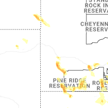
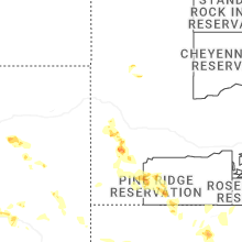
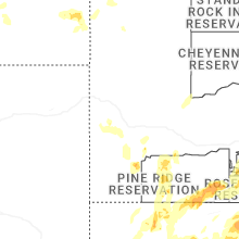


Connect with Interactive Hail Maps