

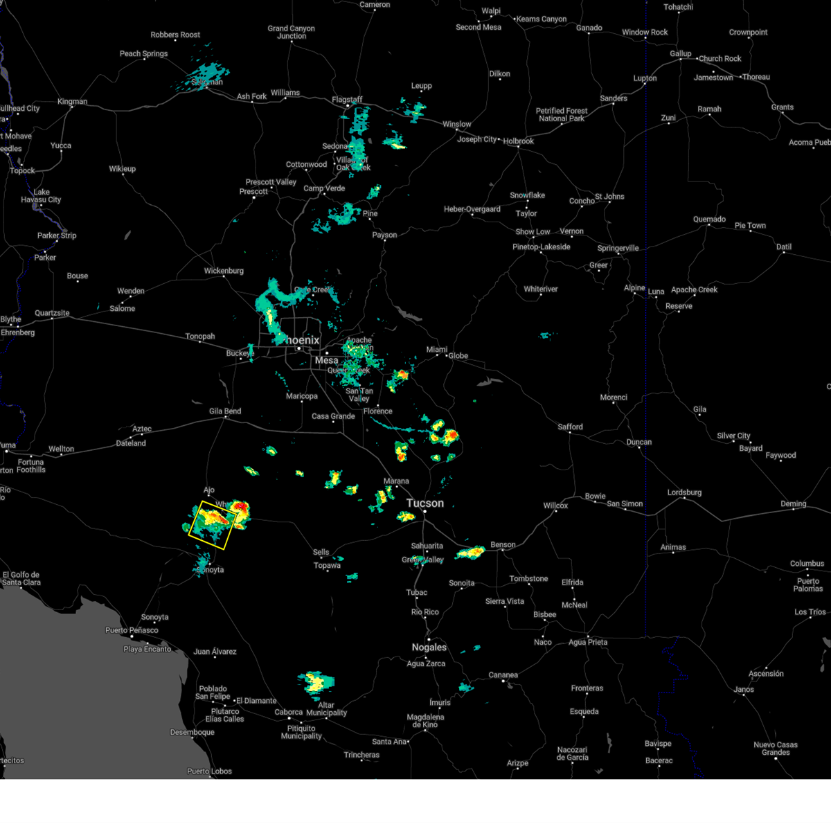
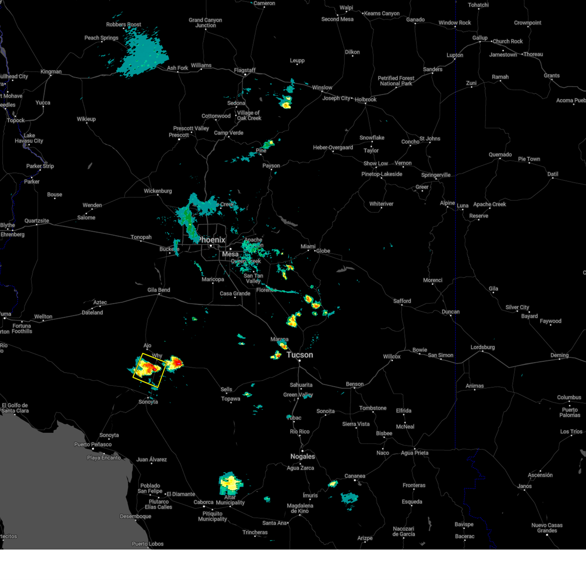
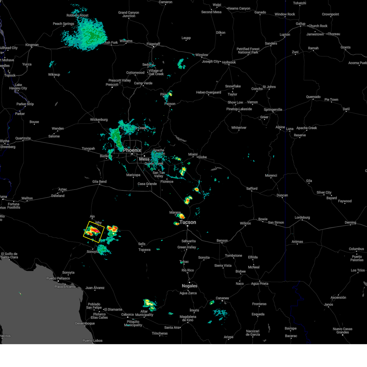
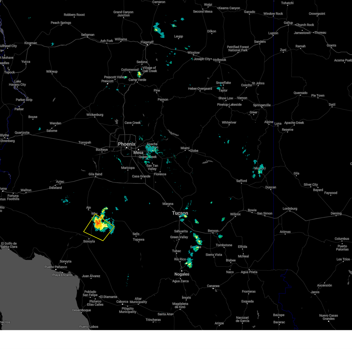
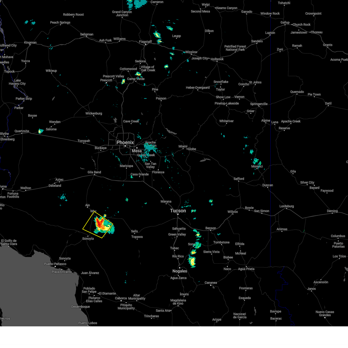
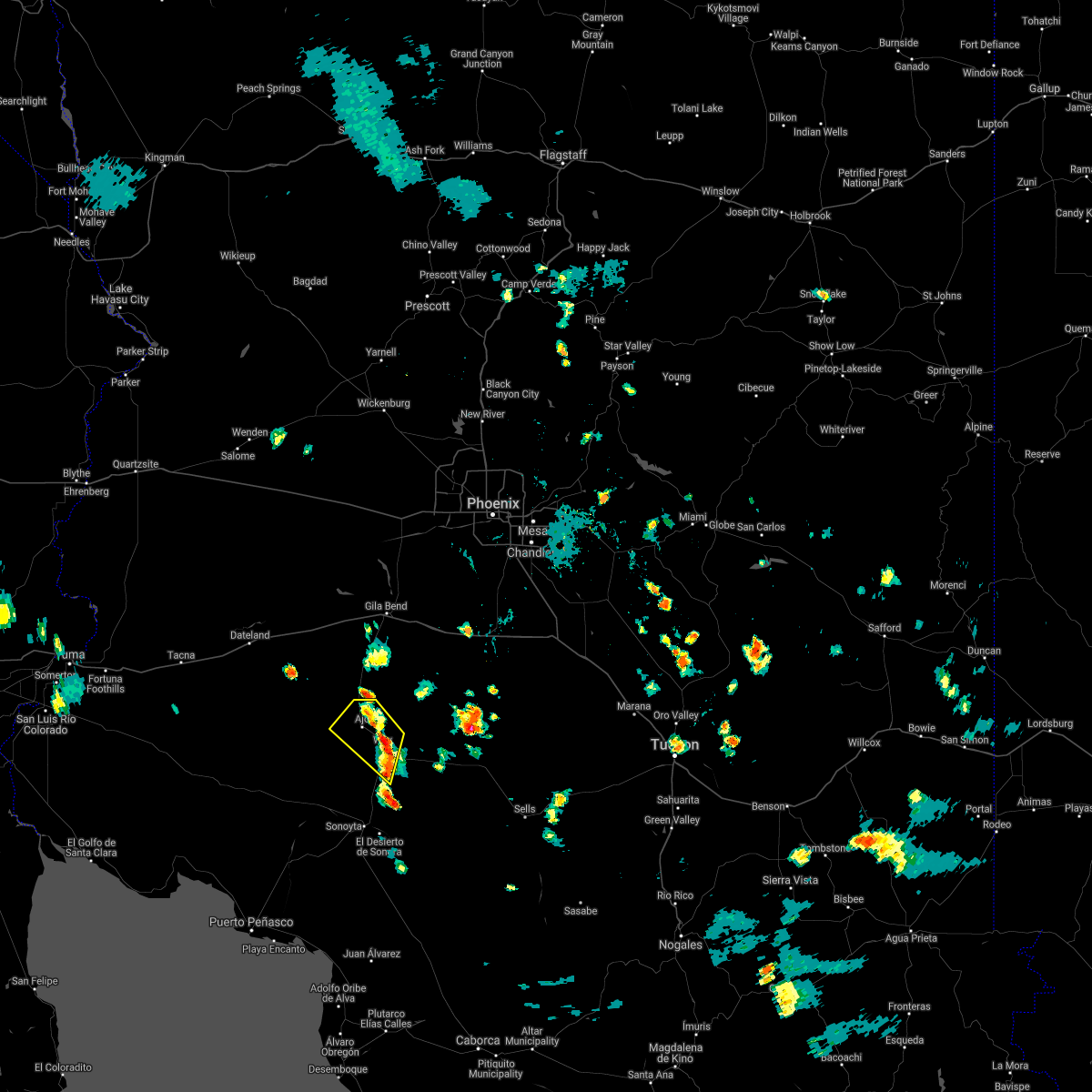
Hail Map for Why, AZ
The Why, AZ area has had 0 reports of on-the-ground hail by trained spotters, and has been under severe weather warnings 10 times during the past 12 months. Doppler radar has detected hail at or near Why, AZ on 28 occasions, including 3 occasions during the past year.
| Name: | Why, AZ |
| Where Located: | 90.4 miles SSW of Phoenix, AZ |
| Map: | Google Map for Why, AZ |
| Population: | 167 |
| Housing Units: | 177 |
| More Info: | Search Google for Why, AZ |
0
The Top Recent Hail Date for Why, AZ is Saturday, August 10, 2024 (22nd out of 28)

Hail and Wind Damage Spotted near Why, AZ
| Date / Time | Report Details |
|---|---|
| 8/3/2024 5:38 PM MST |
 Svrtwc the national weather service in tucson has issued a * severe thunderstorm warning for, northwestern pima county in southeastern arizona, * until 700 pm mst. * at 538 pm mst, severe thunderstorms were located along a line extending from near hickiwan to near guvo, moving west at 25 mph (radar indicated). Hazards include 60 mph wind gusts and quarter size hail. Hail damage to vehicles is expected. Expect wind damage to roofs, siding, and trees. Svrtwc the national weather service in tucson has issued a * severe thunderstorm warning for, northwestern pima county in southeastern arizona, * until 700 pm mst. * at 538 pm mst, severe thunderstorms were located along a line extending from near hickiwan to near guvo, moving west at 25 mph (radar indicated). Hazards include 60 mph wind gusts and quarter size hail. Hail damage to vehicles is expected. Expect wind damage to roofs, siding, and trees.
|
| 7/25/2024 5:57 PM MST |
 The storms which prompted the warning have weakened below severe limits, and no longer pose an immediate threat to life or property. therefore, the warning will be allowed to expire. however, heavy rain is still possible with these thunderstorms. remember, a flash flood warning still remains in effect for organ pipe cactus national monument, ali chugk, and pia oik until 615 pm mst. The storms which prompted the warning have weakened below severe limits, and no longer pose an immediate threat to life or property. therefore, the warning will be allowed to expire. however, heavy rain is still possible with these thunderstorms. remember, a flash flood warning still remains in effect for organ pipe cactus national monument, ali chugk, and pia oik until 615 pm mst.
|
| 7/25/2024 5:40 PM MST |
 At 540 pm mst, severe thunderstorms were located along a line extending from 9 miles east of hickiwan to 6 miles north of ajo, and are nearly stationary (radar indicated). Hazards include 60 mph wind gusts. Expect damage to roofs, siding, and trees. locations impacted include, ajo, guvo, hickiwan, organ pipe cactus national monument, san simon, why, gunsight, ventana, charco 27, vaya chin, kukatch, and san simon west. this includes the following highways, route 85 between mile markers 33 and 70. Route 86 between mile markers 53 and 81. At 540 pm mst, severe thunderstorms were located along a line extending from 9 miles east of hickiwan to 6 miles north of ajo, and are nearly stationary (radar indicated). Hazards include 60 mph wind gusts. Expect damage to roofs, siding, and trees. locations impacted include, ajo, guvo, hickiwan, organ pipe cactus national monument, san simon, why, gunsight, ventana, charco 27, vaya chin, kukatch, and san simon west. this includes the following highways, route 85 between mile markers 33 and 70. Route 86 between mile markers 53 and 81.
|
| 7/25/2024 5:22 PM MST |
 Svrtwc the national weather service in tucson has issued a * severe thunderstorm warning for, northwestern pima county in southeastern arizona, * until 600 pm mst. * at 522 pm mst, severe thunderstorms were located along a line extending from near kaka to 8 miles east of ajo to organ pipe cactus national monument, moving west at 20 mph (radar indicated). Hazards include 60 mph wind gusts and quarter size hail. Hail damage to vehicles is expected. Expect wind damage to roofs, siding, and trees. Svrtwc the national weather service in tucson has issued a * severe thunderstorm warning for, northwestern pima county in southeastern arizona, * until 600 pm mst. * at 522 pm mst, severe thunderstorms were located along a line extending from near kaka to 8 miles east of ajo to organ pipe cactus national monument, moving west at 20 mph (radar indicated). Hazards include 60 mph wind gusts and quarter size hail. Hail damage to vehicles is expected. Expect wind damage to roofs, siding, and trees.
|
| 7/25/2024 5:08 PM MST |
 At 507 pm mst, severe thunderstorms were located along a line extending from 10 miles north of pisinemo to near organ pipe cactus national monument, moving west at 10 mph (radar indicated). Hazards include 60 mph wind gusts and quarter size hail. Hail damage to vehicles is expected. expect wind damage to roofs, siding, and trees. locations impacted include, pisinemo, guvo, hickiwan, organ pipe cactus national monument, san simon, why, gunsight, charco 27, pia oik, vaya chin, santa cruz, kukatch, and san simon west. this includes the following highways, route 85 between mile markers 52 and 77. Route 86 between mile markers 53 and 89. At 507 pm mst, severe thunderstorms were located along a line extending from 10 miles north of pisinemo to near organ pipe cactus national monument, moving west at 10 mph (radar indicated). Hazards include 60 mph wind gusts and quarter size hail. Hail damage to vehicles is expected. expect wind damage to roofs, siding, and trees. locations impacted include, pisinemo, guvo, hickiwan, organ pipe cactus national monument, san simon, why, gunsight, charco 27, pia oik, vaya chin, santa cruz, kukatch, and san simon west. this includes the following highways, route 85 between mile markers 52 and 77. Route 86 between mile markers 53 and 89.
|
| 7/25/2024 4:54 PM MST |
 At 454 pm mst, severe thunderstorms were located along a line extending from near hickiwan to 8 miles southwest of guvo, moving northwest at 10 mph (radar indicated). Hazards include 60 mph wind gusts and quarter size hail. Hail damage to vehicles is expected. expect wind damage to roofs, siding, and trees. locations impacted include, pisinemo, guvo, hickiwan, organ pipe cactus national monument, ali chugk, san simon, why, gunsight, charco 27, pia oik, vaya chin, santa cruz, kukatch, lukeville, and san simon west. this includes the following highways, route 85 between mile markers 52 and 80. Route 86 between mile markers 53 and 89. At 454 pm mst, severe thunderstorms were located along a line extending from near hickiwan to 8 miles southwest of guvo, moving northwest at 10 mph (radar indicated). Hazards include 60 mph wind gusts and quarter size hail. Hail damage to vehicles is expected. expect wind damage to roofs, siding, and trees. locations impacted include, pisinemo, guvo, hickiwan, organ pipe cactus national monument, ali chugk, san simon, why, gunsight, charco 27, pia oik, vaya chin, santa cruz, kukatch, lukeville, and san simon west. this includes the following highways, route 85 between mile markers 52 and 80. Route 86 between mile markers 53 and 89.
|
| 7/25/2024 4:38 PM MST |
 Svrtwc the national weather service in tucson has issued a * severe thunderstorm warning for, northwestern pima county in southeastern arizona, * until 530 pm mst. * at 437 pm mst, severe thunderstorms were located along a line extending from 9 miles southeast of hickiwan to 8 miles southwest of guvo, moving northwest at 15 mph (radar indicated). Hazards include 60 mph wind gusts and quarter size hail. Hail damage to vehicles is expected. Expect wind damage to roofs, siding, and trees. Svrtwc the national weather service in tucson has issued a * severe thunderstorm warning for, northwestern pima county in southeastern arizona, * until 530 pm mst. * at 437 pm mst, severe thunderstorms were located along a line extending from 9 miles southeast of hickiwan to 8 miles southwest of guvo, moving northwest at 15 mph (radar indicated). Hazards include 60 mph wind gusts and quarter size hail. Hail damage to vehicles is expected. Expect wind damage to roofs, siding, and trees.
|
| 7/21/2024 5:45 PM MST |
 The storm which prompted the warning has weakened below severe limits, and no longer poses an immediate threat to life or property. therefore, the warning will be allowed to expire. remember, a severe thunderstorm warning still remains in effect for eastern pima county until 6:30 pm mst. The storm which prompted the warning has weakened below severe limits, and no longer poses an immediate threat to life or property. therefore, the warning will be allowed to expire. remember, a severe thunderstorm warning still remains in effect for eastern pima county until 6:30 pm mst.
|
| 7/21/2024 5:27 PM MST |
 At 526 pm mst, severe thunderstorms were located 9 miles east of ajo, moving southwest at 10 mph (radar indicated). Hazards include 60 mph wind gusts and nickel size hail. Expect damage to roofs, siding, and trees. locations impacted include, guvo, organ pipe cactus national monument, why, gunsight, charco 27, pia oik, santa cruz, kukatch, and san simon west. this includes the following highways, route 85 between mile markers 52 and 64. Route 86 between mile markers 53 and 73. At 526 pm mst, severe thunderstorms were located 9 miles east of ajo, moving southwest at 10 mph (radar indicated). Hazards include 60 mph wind gusts and nickel size hail. Expect damage to roofs, siding, and trees. locations impacted include, guvo, organ pipe cactus national monument, why, gunsight, charco 27, pia oik, santa cruz, kukatch, and san simon west. this includes the following highways, route 85 between mile markers 52 and 64. Route 86 between mile markers 53 and 73.
|
| 7/21/2024 5:07 PM MST |
 Svrtwc the national weather service in tucson has issued a * severe thunderstorm warning for, northwestern pima county in southeastern arizona, * until 545 pm mst. * at 507 pm mst, severe thunderstorms were located 11 miles east of ajo, moving southwest at 10 mph (radar indicated). Hazards include 60 mph wind gusts and nickel size hail. expect damage to roofs, siding, and trees Svrtwc the national weather service in tucson has issued a * severe thunderstorm warning for, northwestern pima county in southeastern arizona, * until 545 pm mst. * at 507 pm mst, severe thunderstorms were located 11 miles east of ajo, moving southwest at 10 mph (radar indicated). Hazards include 60 mph wind gusts and nickel size hail. expect damage to roofs, siding, and trees
|
| 7/11/2024 8:38 PM MST |
 The storm which prompted the warning has weakened below severe limits, and no longer poses an immediate threat to life or property. therefore, the warning will be allowed to expire. however, heavy rain is still possible with this thunderstorm and a flash flood warning remains in effect until 1145 pm mst. The storm which prompted the warning has weakened below severe limits, and no longer poses an immediate threat to life or property. therefore, the warning will be allowed to expire. however, heavy rain is still possible with this thunderstorm and a flash flood warning remains in effect until 1145 pm mst.
|
| 7/11/2024 7:29 PM MST |
 Svrtwc the national weather service in tucson has issued a * severe thunderstorm warning for, northwestern pima county in southeastern arizona, * until 845 pm mst. * at 728 pm mst, an area of severe thunderstorms was located across western portions of the tohono o'odham nation into western pima county, moving west at 15 mph (radar indicated). Hazards include 60 mph wind gusts and penny size hail. expect damage to roofs, siding, and trees Svrtwc the national weather service in tucson has issued a * severe thunderstorm warning for, northwestern pima county in southeastern arizona, * until 845 pm mst. * at 728 pm mst, an area of severe thunderstorms was located across western portions of the tohono o'odham nation into western pima county, moving west at 15 mph (radar indicated). Hazards include 60 mph wind gusts and penny size hail. expect damage to roofs, siding, and trees
|
| 7/11/2024 6:52 PM MST |
 Svrtwc the national weather service in tucson has issued a * severe thunderstorm warning for, northwestern pima county in southeastern arizona, * until 730 pm mst. * at 652 pm mst, a severe thunderstorm was located 7 miles northwest of pisinemo, or 32 miles southeast of ajo, moving southwest at 15 mph (radar indicated). Hazards include 60 mph wind gusts and penny size hail. expect damage to roofs, siding, and trees Svrtwc the national weather service in tucson has issued a * severe thunderstorm warning for, northwestern pima county in southeastern arizona, * until 730 pm mst. * at 652 pm mst, a severe thunderstorm was located 7 miles northwest of pisinemo, or 32 miles southeast of ajo, moving southwest at 15 mph (radar indicated). Hazards include 60 mph wind gusts and penny size hail. expect damage to roofs, siding, and trees
|
| 8/18/2023 4:43 PM MST |
 At 443 pm mst, a severe thunderstorm was located near ajo, moving north at 40 mph (radar indicated). Hazards include 70 mph wind gusts and quarter size hail. Hail damage to vehicles is expected. expect considerable tree damage. Wind damage is also likely to mobile homes, roofs, and outbuildings. At 443 pm mst, a severe thunderstorm was located near ajo, moving north at 40 mph (radar indicated). Hazards include 70 mph wind gusts and quarter size hail. Hail damage to vehicles is expected. expect considerable tree damage. Wind damage is also likely to mobile homes, roofs, and outbuildings.
|
| 8/18/2023 3:56 PM MST |
 At 355 pm mst, a severe thunderstorm was located near gu vo, or 24 miles southeast of ajo, moving north at 30 mph (radar indicated). Hazards include 70 mph wind gusts and quarter size hail. Hail damage to vehicles is expected. expect considerable tree damage. Wind damage is also likely to mobile homes, roofs, and outbuildings. At 355 pm mst, a severe thunderstorm was located near gu vo, or 24 miles southeast of ajo, moving north at 30 mph (radar indicated). Hazards include 70 mph wind gusts and quarter size hail. Hail damage to vehicles is expected. expect considerable tree damage. Wind damage is also likely to mobile homes, roofs, and outbuildings.
|
| 7/30/2023 6:54 PM MST |
 The severe thunderstorm warning for west central pima county will expire at 700 pm mst, the storm which prompted the warning has weakened below severe limits, and no longer poses an immediate threat to life or property. therefore, the warning will be allowed to expire. however heavy rain is still possible with this thunderstorm and a flood advisory is in effect until 945 pm mst. The severe thunderstorm warning for west central pima county will expire at 700 pm mst, the storm which prompted the warning has weakened below severe limits, and no longer poses an immediate threat to life or property. therefore, the warning will be allowed to expire. however heavy rain is still possible with this thunderstorm and a flood advisory is in effect until 945 pm mst.
|
| 7/30/2023 6:34 PM MST |
 At 634 pm mst, a severe thunderstorm was located 8 miles north of organ pipe cactus national monument, or 15 miles south of ajo, moving west at 5 mph (radar indicated). Hazards include 60 mph wind gusts and quarter size hail. Hail damage to vehicles is expected. expect wind damage to roofs, siding, and trees. locations impacted include, organ pipe cactus national monument, why and gunsight. hail threat, radar indicated max hail size, 1. 00 in wind threat, radar indicated max wind gust, 60 mph. At 634 pm mst, a severe thunderstorm was located 8 miles north of organ pipe cactus national monument, or 15 miles south of ajo, moving west at 5 mph (radar indicated). Hazards include 60 mph wind gusts and quarter size hail. Hail damage to vehicles is expected. expect wind damage to roofs, siding, and trees. locations impacted include, organ pipe cactus national monument, why and gunsight. hail threat, radar indicated max hail size, 1. 00 in wind threat, radar indicated max wind gust, 60 mph.
|
| 7/30/2023 6:14 PM MST |
 At 614 pm mst, a severe thunderstorm was located 8 miles north of organ pipe cactus national monument, or 16 miles south of ajo, moving northwest at 5 mph (radar indicated). Hazards include 60 mph wind gusts and quarter size hail. Hail damage to vehicles is expected. Expect wind damage to roofs, siding, and trees. At 614 pm mst, a severe thunderstorm was located 8 miles north of organ pipe cactus national monument, or 16 miles south of ajo, moving northwest at 5 mph (radar indicated). Hazards include 60 mph wind gusts and quarter size hail. Hail damage to vehicles is expected. Expect wind damage to roofs, siding, and trees.
|
| 7/25/2023 6:36 PM MST |
 The severe thunderstorm warning for northwestern pima county will expire at 645 pm mst, the storm which prompted the warning has weakened below severe limits, and no longer poses an immediate threat to life or property. therefore, the warning will be allowed to expire. however strong gusty winds are still possible with this thunderstorm. The severe thunderstorm warning for northwestern pima county will expire at 645 pm mst, the storm which prompted the warning has weakened below severe limits, and no longer poses an immediate threat to life or property. therefore, the warning will be allowed to expire. however strong gusty winds are still possible with this thunderstorm.
|
| 7/25/2023 6:20 PM MST |
 At 620 pm mst, a severe thunderstorm was located 7 miles west of gu vo, or 22 miles southeast of ajo, moving northwest at 15 mph (radar indicated). Hazards include 60 mph wind gusts and quarter size hail. Hail damage to vehicles is expected. expect wind damage to roofs, siding, and trees. locations impacted include, gu vo, organ pipe cactus national monument, why, gunsight, pia oik and kuakatch. hail threat, radar indicated max hail size, 1. 00 in wind threat, radar indicated max wind gust, 60 mph. At 620 pm mst, a severe thunderstorm was located 7 miles west of gu vo, or 22 miles southeast of ajo, moving northwest at 15 mph (radar indicated). Hazards include 60 mph wind gusts and quarter size hail. Hail damage to vehicles is expected. expect wind damage to roofs, siding, and trees. locations impacted include, gu vo, organ pipe cactus national monument, why, gunsight, pia oik and kuakatch. hail threat, radar indicated max hail size, 1. 00 in wind threat, radar indicated max wind gust, 60 mph.
|
| 7/25/2023 5:56 PM MST |
 At 555 pm mst, a severe thunderstorm was located over gu vo, or 29 miles southeast of ajo, moving northwest at 15 mph (radar indicated). Hazards include 60 mph wind gusts and quarter size hail. Hail damage to vehicles is expected. Expect wind damage to roofs, siding, and trees. At 555 pm mst, a severe thunderstorm was located over gu vo, or 29 miles southeast of ajo, moving northwest at 15 mph (radar indicated). Hazards include 60 mph wind gusts and quarter size hail. Hail damage to vehicles is expected. Expect wind damage to roofs, siding, and trees.
|
| 7/24/2023 4:40 PM MST |
 The severe thunderstorm warning for northwestern pima county will expire at 445 pm mst, the storm which prompted the warning has weakened below severe limits, and no longer poses an immediate threat to life or property. therefore, the warning will be allowed to expire. however gusty winds are still possible with this thunderstorm. The severe thunderstorm warning for northwestern pima county will expire at 445 pm mst, the storm which prompted the warning has weakened below severe limits, and no longer poses an immediate threat to life or property. therefore, the warning will be allowed to expire. however gusty winds are still possible with this thunderstorm.
|
| 7/24/2023 4:19 PM MST |
 At 419 pm mst, a severe thunderstorm was located 9 miles northwest of ajo, moving northwest at 15 mph (radar indicated). Hazards include 60 mph wind gusts and quarter size hail. Hail damage to vehicles is expected. expect wind damage to roofs, siding, and trees. locations impacted include, ajo. hail threat, radar indicated max hail size, 1. 00 in wind threat, radar indicated max wind gust, 60 mph. At 419 pm mst, a severe thunderstorm was located 9 miles northwest of ajo, moving northwest at 15 mph (radar indicated). Hazards include 60 mph wind gusts and quarter size hail. Hail damage to vehicles is expected. expect wind damage to roofs, siding, and trees. locations impacted include, ajo. hail threat, radar indicated max hail size, 1. 00 in wind threat, radar indicated max wind gust, 60 mph.
|
| 7/24/2023 3:55 PM MST |
 At 355 pm mst, a severe thunderstorm was located near ajo, moving northwest at 15 mph (radar indicated). Hazards include 60 mph wind gusts and quarter size hail. Hail damage to vehicles is expected. Expect wind damage to roofs, siding, and trees. At 355 pm mst, a severe thunderstorm was located near ajo, moving northwest at 15 mph (radar indicated). Hazards include 60 mph wind gusts and quarter size hail. Hail damage to vehicles is expected. Expect wind damage to roofs, siding, and trees.
|
| 9/23/2022 5:12 PM MST |
 The severe thunderstorm warning for northwestern pima county will expire at 515 pm mst, the storm which prompted the warning has weakened below severe limits. therefore, the warning will be allowed to expire. however heavy rain is still possible with this thunderstorm, and a flash flood warning remains in effect until 6:30 pm mst in and around the ajo area in western pima county. The severe thunderstorm warning for northwestern pima county will expire at 515 pm mst, the storm which prompted the warning has weakened below severe limits. therefore, the warning will be allowed to expire. however heavy rain is still possible with this thunderstorm, and a flash flood warning remains in effect until 6:30 pm mst in and around the ajo area in western pima county.
|
| 9/23/2022 4:24 PM MST |
 At 424 pm mst, a severe thunderstorm was located over ajo, and is nearly stationary (radar indicated). Hazards include 60 mph wind gusts and quarter size hail. Hail damage to vehicles is expected. Expect wind damage to roofs, siding, and trees. At 424 pm mst, a severe thunderstorm was located over ajo, and is nearly stationary (radar indicated). Hazards include 60 mph wind gusts and quarter size hail. Hail damage to vehicles is expected. Expect wind damage to roofs, siding, and trees.
|
| 8/21/2022 9:39 PM MST | The severe thunderstorm warning for northwestern pima county will expire at 945 pm mst, the storms which prompted the warning near and east of ajo have moved out of the area. therefore, the warning will be allowed to expire, with a new warning further south toward organ pipe national monument. heavy rain is still expected with these thunderstorms. |
| 8/21/2022 8:56 PM MST | At 856 pm mst, severe thunderstorms were located along a line extending from 11 miles north of ajo to near kaka, moving south at 25 mph (radar indicated). Hazards include 60 mph wind gusts and penny size hail. expect damage to roofs, siding, and trees |
| 8/13/2022 6:22 PM MST |
 The severe thunderstorm warning for northwestern pima county will expire at 630 pm mst, the storm which prompted the warning near ajo has weakened below severe limits. therefore, the warning will be allowed to expire. however heavy rain is still possible with this thunderstorm. The severe thunderstorm warning for northwestern pima county will expire at 630 pm mst, the storm which prompted the warning near ajo has weakened below severe limits. therefore, the warning will be allowed to expire. however heavy rain is still possible with this thunderstorm.
|
| 8/13/2022 5:49 PM MST |
 At 548 pm mst, a severe thunderstorm was located near and south of ajo, moving north at 5 mph (radar indicated). Hazards include 60 mph wind gusts and penny size hail. expect damage to roofs, siding, and trees At 548 pm mst, a severe thunderstorm was located near and south of ajo, moving north at 5 mph (radar indicated). Hazards include 60 mph wind gusts and penny size hail. expect damage to roofs, siding, and trees
|
| 7/16/2022 8:27 PM MST |
 The severe thunderstorm warning for northwestern pima county will expire at 830 pm mst, the storm which prompted the warning has weakened below severe limits, and no longer poses an immediate threat to life or property. therefore, the warning will be allowed to expire. however gusty winds are still possible. The severe thunderstorm warning for northwestern pima county will expire at 830 pm mst, the storm which prompted the warning has weakened below severe limits, and no longer poses an immediate threat to life or property. therefore, the warning will be allowed to expire. however gusty winds are still possible.
|
| 7/16/2022 8:15 PM MST |
 At 814 pm mst, a severe thunderstorm was located 10 miles north of gu vo, or 18 miles southeast of ajo, moving west at 20 mph (radar indicated). Hazards include 60 mph wind gusts, quarter size hail and blowing dust. Hail damage to vehicles is expected. expect wind damage to roofs, siding, and trees. locations impacted include, gu vo, hickiwan, organ pipe cactus national monument, san simon, why, charco 27, gunsight, kuakatch and san simon west. hail threat, radar indicated max hail size, 1. 00 in wind threat, radar indicated max wind gust, 60 mph. At 814 pm mst, a severe thunderstorm was located 10 miles north of gu vo, or 18 miles southeast of ajo, moving west at 20 mph (radar indicated). Hazards include 60 mph wind gusts, quarter size hail and blowing dust. Hail damage to vehicles is expected. expect wind damage to roofs, siding, and trees. locations impacted include, gu vo, hickiwan, organ pipe cactus national monument, san simon, why, charco 27, gunsight, kuakatch and san simon west. hail threat, radar indicated max hail size, 1. 00 in wind threat, radar indicated max wind gust, 60 mph.
|
| 7/16/2022 7:43 PM MST |
 At 742 pm mst, a severe thunderstorm was located 11 miles south of hickiwan, or 28 miles southeast of ajo, moving west at 30 mph (radar indicated). Hazards include 60 mph wind gusts, quarter size hail, and blowing dust. Hail damage to vehicles is expected. Expect wind damage to roofs, siding, and trees. At 742 pm mst, a severe thunderstorm was located 11 miles south of hickiwan, or 28 miles southeast of ajo, moving west at 30 mph (radar indicated). Hazards include 60 mph wind gusts, quarter size hail, and blowing dust. Hail damage to vehicles is expected. Expect wind damage to roofs, siding, and trees.
|
| 8/28/2021 8:53 PM MST |
 The severe thunderstorm warning for northwestern pima county will expire at 900 pm mst, the storm which prompted the warning has weakened below severe limits, and no longer poses an immediate threat to life or property. therefore, the warning will be allowed to expire. however gusty winds and heavy rain are still possible with this thunderstorm and a flash flood warning remains in effect. The severe thunderstorm warning for northwestern pima county will expire at 900 pm mst, the storm which prompted the warning has weakened below severe limits, and no longer poses an immediate threat to life or property. therefore, the warning will be allowed to expire. however gusty winds and heavy rain are still possible with this thunderstorm and a flash flood warning remains in effect.
|
| 8/28/2021 8:26 PM MST |
 At 826 pm mst, a severe thunderstorm was located 10 miles southwest of hickiwan, or 17 miles southeast of ajo, and is nearly stationary (radar indicated). Hazards include 60 mph wind gusts and quarter size hail. Hail damage to vehicles is expected. expect wind damage to roofs, siding, and trees. locations impacted include, gu vo, hickiwan, organ pipe cactus national monument, why, charco 27, gunsight and kuakatch. hail threat, radar indicated max hail size, 1. 00 in wind threat, radar indicated max wind gust, 60 mph. At 826 pm mst, a severe thunderstorm was located 10 miles southwest of hickiwan, or 17 miles southeast of ajo, and is nearly stationary (radar indicated). Hazards include 60 mph wind gusts and quarter size hail. Hail damage to vehicles is expected. expect wind damage to roofs, siding, and trees. locations impacted include, gu vo, hickiwan, organ pipe cactus national monument, why, charco 27, gunsight and kuakatch. hail threat, radar indicated max hail size, 1. 00 in wind threat, radar indicated max wind gust, 60 mph.
|
| 8/28/2021 8:03 PM MST |
 At 803 pm mst, a severe thunderstorm was located 7 miles northwest of gu vo, or 20 miles southeast of ajo, and is nearly stationary (radar indicated). Hazards include 60 mph wind gusts and quarter size hail. Hail damage to vehicles is expected. Expect wind damage to roofs, siding, and trees. At 803 pm mst, a severe thunderstorm was located 7 miles northwest of gu vo, or 20 miles southeast of ajo, and is nearly stationary (radar indicated). Hazards include 60 mph wind gusts and quarter size hail. Hail damage to vehicles is expected. Expect wind damage to roofs, siding, and trees.
|
| 7/30/2021 6:08 PM MST |
 The severe thunderstorm warning for northwestern pima county will expire at 615 pm mst, the storm which prompted the warning has weakened below severe limits, and has exited the warned area. therefore, the warning will be allowed to expire. however heavy rain is still possible with this thunderstorm. The severe thunderstorm warning for northwestern pima county will expire at 615 pm mst, the storm which prompted the warning has weakened below severe limits, and has exited the warned area. therefore, the warning will be allowed to expire. however heavy rain is still possible with this thunderstorm.
|
| 7/30/2021 5:48 PM MST |
 At 544 pm mst, a severe thunderstorm was located near ajo, moving northwest at 10 mph (radar indicated). Hazards include 60 mph wind gusts and penny size hail. Expect damage to roofs, siding, and trees. locations impacted include, ajo, why and gunsight. this includes the following highways, route 85 between mile markers 33 and 62. Route 86 between mile markers 53 and 60. At 544 pm mst, a severe thunderstorm was located near ajo, moving northwest at 10 mph (radar indicated). Hazards include 60 mph wind gusts and penny size hail. Expect damage to roofs, siding, and trees. locations impacted include, ajo, why and gunsight. this includes the following highways, route 85 between mile markers 33 and 62. Route 86 between mile markers 53 and 60.
|
| 7/30/2021 5:20 PM MST |
 At 519 pm mst, a severe thunderstorm was located 7 miles southeast of ajo, moving northwest at 10 mph (radar indicated). Hazards include 60 mph wind gusts and quarter size hail. Hail damage to vehicles is expected. Expect wind damage to roofs, siding, and trees. At 519 pm mst, a severe thunderstorm was located 7 miles southeast of ajo, moving northwest at 10 mph (radar indicated). Hazards include 60 mph wind gusts and quarter size hail. Hail damage to vehicles is expected. Expect wind damage to roofs, siding, and trees.
|
| 7/21/2021 2:16 PM MST |
 At 215 pm mst, a severe thunderstorm was located 8 miles south of ajo, moving west at 10 mph (radar indicated). Hazards include 60 mph wind gusts and quarter size hail. Hail damage to vehicles is expected. Expect wind damage to roofs, siding, and trees. At 215 pm mst, a severe thunderstorm was located 8 miles south of ajo, moving west at 10 mph (radar indicated). Hazards include 60 mph wind gusts and quarter size hail. Hail damage to vehicles is expected. Expect wind damage to roofs, siding, and trees.
|
| 7/10/2021 10:40 PM MST |
 The severe thunderstorm warning for northwestern pima county will expire at 1045 pm mst, the storm which prompted the warning has weakened below severe limits, and no longer poses an immediate threat to life or property. therefore, the warning will be allowed to expire. however gusty winds and brief heavy rain are still possible with this thunderstorm. a severe thunderstorm watch remains in effect until midnight mst for southeastern arizona. The severe thunderstorm warning for northwestern pima county will expire at 1045 pm mst, the storm which prompted the warning has weakened below severe limits, and no longer poses an immediate threat to life or property. therefore, the warning will be allowed to expire. however gusty winds and brief heavy rain are still possible with this thunderstorm. a severe thunderstorm watch remains in effect until midnight mst for southeastern arizona.
|
| 7/10/2021 10:03 PM MST |
 At 1002 pm mst, a severe thunderstorm was located 11 miles southeast of ajo, moving southwest at 25 mph (radar indicated). Hazards include 60 mph wind gusts and quarter size hail. Hail damage to vehicles is expected. Expect wind damage to roofs, siding, and trees. At 1002 pm mst, a severe thunderstorm was located 11 miles southeast of ajo, moving southwest at 25 mph (radar indicated). Hazards include 60 mph wind gusts and quarter size hail. Hail damage to vehicles is expected. Expect wind damage to roofs, siding, and trees.
|
| 8/20/2020 11:05 PM MST |
 At 1104 pm mst, severe thunderstorms were located along a line extending from near ajo to 8 miles south of santa rosa, moving southwest at 25 mph (radar indicated). Hazards include 60 mph wind gusts. Expect damage to roofs, siding, and trees. locations impacted include, ajo, santa rosa, pisinemo, hickiwan, covered wells, anegam, san simon, why, palo verde stand, ak chin, gunsight, vaya chin, mountain village, san luis, kuakatch, santa rosa school. this includes the following highways, route 85 between mile markers 33 and 61. Route 86 between mile markers 53 and 97. At 1104 pm mst, severe thunderstorms were located along a line extending from near ajo to 8 miles south of santa rosa, moving southwest at 25 mph (radar indicated). Hazards include 60 mph wind gusts. Expect damage to roofs, siding, and trees. locations impacted include, ajo, santa rosa, pisinemo, hickiwan, covered wells, anegam, san simon, why, palo verde stand, ak chin, gunsight, vaya chin, mountain village, san luis, kuakatch, santa rosa school. this includes the following highways, route 85 between mile markers 33 and 61. Route 86 between mile markers 53 and 97.
|
| 8/20/2020 10:30 PM MST |
 At 1028 pm mst, severe thunderstorms were located along a line extending from 10 miles north of ajo to 6 miles northeast of santa rosa, moving southwest at 20 mph (radar indicated). Hazards include 60 mph wind gusts. expect damage to roofs, siding, and trees At 1028 pm mst, severe thunderstorms were located along a line extending from 10 miles north of ajo to 6 miles northeast of santa rosa, moving southwest at 20 mph (radar indicated). Hazards include 60 mph wind gusts. expect damage to roofs, siding, and trees
|
| 8/17/2020 10:12 PM MST |
 The severe thunderstorm warning for northwestern pima county will expire at 1015 pm mst, the storm which prompted the warning has weakened below severe limits, and no longer poses an immediate threat to life or property. therefore, the warning will be allowed to expire. The severe thunderstorm warning for northwestern pima county will expire at 1015 pm mst, the storm which prompted the warning has weakened below severe limits, and no longer poses an immediate threat to life or property. therefore, the warning will be allowed to expire.
|
| 8/17/2020 9:51 PM MST |
 At 950 pm mst, a severe thunderstorm was located 10 miles south of ajo, just west of why, moving west at 30 mph (radar indicated). Hazards include 60 mph wind gusts and nickel size hail. Expect damage to roofs, siding, and trees. locations impacted include, ajo, why and gunsight. this includes the following highways, route 85 between mile markers 40 and 61. Route 86 between mile markers 53 and 61. At 950 pm mst, a severe thunderstorm was located 10 miles south of ajo, just west of why, moving west at 30 mph (radar indicated). Hazards include 60 mph wind gusts and nickel size hail. Expect damage to roofs, siding, and trees. locations impacted include, ajo, why and gunsight. this includes the following highways, route 85 between mile markers 40 and 61. Route 86 between mile markers 53 and 61.
|
| 8/17/2020 9:28 PM MST |
 At 927 pm mst, a severe thunderstorm was located just east of why, or 12 miles southeast of ajo, moving west at 25 mph (radar indicated). Hazards include 60 mph wind gusts and nickel size hail. expect damage to roofs, siding, and trees At 927 pm mst, a severe thunderstorm was located just east of why, or 12 miles southeast of ajo, moving west at 25 mph (radar indicated). Hazards include 60 mph wind gusts and nickel size hail. expect damage to roofs, siding, and trees
|
| 9/24/2019 2:18 AM MST |
 At 217 am mst, a severe thunderstorm was located 12 miles south of ajo, moving north at 20 mph. another severe thunderstorm was located in extreme southwestern pima county, moving toward the northeast around 15 mph (radar indicated). Hazards include 60 mph wind gusts and quarter size hail. Hail damage to vehicles is expected. Expect wind damage to roofs, siding, and trees. At 217 am mst, a severe thunderstorm was located 12 miles south of ajo, moving north at 20 mph. another severe thunderstorm was located in extreme southwestern pima county, moving toward the northeast around 15 mph (radar indicated). Hazards include 60 mph wind gusts and quarter size hail. Hail damage to vehicles is expected. Expect wind damage to roofs, siding, and trees.
|
| 9/1/2019 5:40 PM MST |
 The severe thunderstorm warning for northwestern pima county will expire at 545 pm mst, the storms which prompted the warning have weakened below severe limits, and no longer pose an immediate threat to life or property. therefore, the warning will be allowed to expire. however heavy rain is still possible with these thunderstorms. The severe thunderstorm warning for northwestern pima county will expire at 545 pm mst, the storms which prompted the warning have weakened below severe limits, and no longer pose an immediate threat to life or property. therefore, the warning will be allowed to expire. however heavy rain is still possible with these thunderstorms.
|
| 9/1/2019 5:27 PM MST |
 At 527 pm mst, severe thunderstorms were located along a line extending from 10 miles west of hickiwan to 12 miles southeast of ajo to 17 miles northwest of organ pipe cactus national monument, moving northwest at 30 mph (radar indicated). Hazards include 60 mph wind gusts and quarter size hail. Hail damage to vehicles is expected. expect wind damage to roofs, siding, and trees. locations impacted include, ajo, organ pipe cactus national monument, why, charco 27 and gunsight. this includes the following highways, route 85 between mile markers 37 and 66. Route 86 between mile markers 53 and 62. At 527 pm mst, severe thunderstorms were located along a line extending from 10 miles west of hickiwan to 12 miles southeast of ajo to 17 miles northwest of organ pipe cactus national monument, moving northwest at 30 mph (radar indicated). Hazards include 60 mph wind gusts and quarter size hail. Hail damage to vehicles is expected. expect wind damage to roofs, siding, and trees. locations impacted include, ajo, organ pipe cactus national monument, why, charco 27 and gunsight. this includes the following highways, route 85 between mile markers 37 and 66. Route 86 between mile markers 53 and 62.
|
| 9/1/2019 5:11 PM MST |
 At 511 pm mst, severe thunderstorms were located along a line extending from 6 miles west of hickiwan to 11 miles northwest of gu vo to 13 miles northwest of organ pipe cactus national monument, moving northwest at 20 mph (radar indicated). Hazards include 60 mph wind gusts and quarter size hail. Hail damage to vehicles is expected. expect wind damage to roofs, siding, and trees. locations impacted include, ajo, gu vo, hickiwan, organ pipe cactus national monument, why, charco 27, gunsight and kuakatch. this includes the following highways, route 85 between mile markers 37 and 68. Route 86 between mile markers 53 and 68. At 511 pm mst, severe thunderstorms were located along a line extending from 6 miles west of hickiwan to 11 miles northwest of gu vo to 13 miles northwest of organ pipe cactus national monument, moving northwest at 20 mph (radar indicated). Hazards include 60 mph wind gusts and quarter size hail. Hail damage to vehicles is expected. expect wind damage to roofs, siding, and trees. locations impacted include, ajo, gu vo, hickiwan, organ pipe cactus national monument, why, charco 27, gunsight and kuakatch. this includes the following highways, route 85 between mile markers 37 and 68. Route 86 between mile markers 53 and 68.
|
| 9/1/2019 4:50 PM MST |
 At 450 pm mst, severe thunderstorms were located along a line extending from 6 miles southwest of hickiwan to near gu vo to 8 miles north of organ pipe cactus national monument, moving northwest at 25 mph (radar indicated). Hazards include 60 mph wind gusts and quarter size hail. Hail damage to vehicles is expected. Expect wind damage to roofs, siding, and trees. At 450 pm mst, severe thunderstorms were located along a line extending from 6 miles southwest of hickiwan to near gu vo to 8 miles north of organ pipe cactus national monument, moving northwest at 25 mph (radar indicated). Hazards include 60 mph wind gusts and quarter size hail. Hail damage to vehicles is expected. Expect wind damage to roofs, siding, and trees.
|
| 8/24/2018 7:27 PM MST |
 The severe thunderstorm warning for northwestern pima county will expire at 730 pm mst, the storm which prompted the warning has weakened below severe limits, and no longer poses an immediate threat to life or property. therefore, the warning will be allowed to expire. however gusty winds and heavy rain are still possible with these thunderstorms. The severe thunderstorm warning for northwestern pima county will expire at 730 pm mst, the storm which prompted the warning has weakened below severe limits, and no longer poses an immediate threat to life or property. therefore, the warning will be allowed to expire. however gusty winds and heavy rain are still possible with these thunderstorms.
|
| 8/24/2018 7:16 PM MST |
 At 713 pm mst, severe thunderstorms were located just west of santa cruz up to near ajo and were moving north at 10 mph. be on the look out for the potential for blowing dust as well as new thunderstorm development (radar indicated). Hazards include 60 mph wind gusts and penny size hail. Expect damage to roofs, siding, and trees. locations impacted include, ajo, organ pipe national monument, ali chuk, lukeville, kuakatch, gu vo, why, gunsight, charco 27 and pia oik. this includes the following highways, route 85 between mile markers 33 and 80. Route 86 between mile markers 53 and 67. At 713 pm mst, severe thunderstorms were located just west of santa cruz up to near ajo and were moving north at 10 mph. be on the look out for the potential for blowing dust as well as new thunderstorm development (radar indicated). Hazards include 60 mph wind gusts and penny size hail. Expect damage to roofs, siding, and trees. locations impacted include, ajo, organ pipe national monument, ali chuk, lukeville, kuakatch, gu vo, why, gunsight, charco 27 and pia oik. this includes the following highways, route 85 between mile markers 33 and 80. Route 86 between mile markers 53 and 67.
|
| 8/24/2018 6:46 PM MST |
 At 645 pm mst, a severe thunderstorm was located 7 miles east of organ pipe national monument, or 46 miles west of sells, moving northwest at 10 mph (radar indicated). Hazards include 60 mph wind gusts and nickel size hail. expect damage to roofs, siding, and trees At 645 pm mst, a severe thunderstorm was located 7 miles east of organ pipe national monument, or 46 miles west of sells, moving northwest at 10 mph (radar indicated). Hazards include 60 mph wind gusts and nickel size hail. expect damage to roofs, siding, and trees
|
| 8/12/2018 8:44 PM MST |
 At 842 pm mst, severe thunderstorms were located along a line extending from 16 miles northeast of ajo to 10 miles east of why, moving west at 15 mph (radar indicated). Hazards include 60 mph wind gusts and quarter size hail, along with dense blowing dust followed by heavy rain. Hail damage to vehicles is expected. Expect wind damage to roofs, siding, and trees. At 842 pm mst, severe thunderstorms were located along a line extending from 16 miles northeast of ajo to 10 miles east of why, moving west at 15 mph (radar indicated). Hazards include 60 mph wind gusts and quarter size hail, along with dense blowing dust followed by heavy rain. Hail damage to vehicles is expected. Expect wind damage to roofs, siding, and trees.
|
| 7/9/2018 7:26 PM MST |
 The severe thunderstorm warning for northwestern pima county will expire at 730 pm mst, the storm which prompted the warning has weakened below severe limits, and no longer poses an immediate threat to life or property. therefore, the warning will be allowed to expire. however gusty winds and heavy rain are still possible with this thunderstorm. The severe thunderstorm warning for northwestern pima county will expire at 730 pm mst, the storm which prompted the warning has weakened below severe limits, and no longer poses an immediate threat to life or property. therefore, the warning will be allowed to expire. however gusty winds and heavy rain are still possible with this thunderstorm.
|
| 7/9/2018 7:00 PM MST |
 At 645 pm mst, a severe thunderstorm was located over ajo, or 37 miles south of gila bend, moving west at 30 mph (radar indicated). Hazards include 60 mph wind gusts and penny size hail. expect damage to roofs, siding, and trees At 645 pm mst, a severe thunderstorm was located over ajo, or 37 miles south of gila bend, moving west at 30 mph (radar indicated). Hazards include 60 mph wind gusts and penny size hail. expect damage to roofs, siding, and trees
|
| 7/9/2018 6:45 PM MST |
 At 645 pm mst, a severe thunderstorm was located over ajo, or 37 miles south of gila bend, moving west at 30 mph (radar indicated). Hazards include 60 mph wind gusts and penny size hail. expect damage to roofs, siding, and trees At 645 pm mst, a severe thunderstorm was located over ajo, or 37 miles south of gila bend, moving west at 30 mph (radar indicated). Hazards include 60 mph wind gusts and penny size hail. expect damage to roofs, siding, and trees
|
| 7/8/2018 7:13 PM MST |
 At 710 pm mst, a severe thunderstorm was located near highway 86 about 10 to 15 miles southeast of ajo, moving west at 15 to 20 mph (radar indicated). Hazards include 70 mph wind gusts and quarter size hail. Hail damage to vehicles is expected. expect considerable tree damage. Wind damage is also likely to mobile homes, roofs, and outbuildings. At 710 pm mst, a severe thunderstorm was located near highway 86 about 10 to 15 miles southeast of ajo, moving west at 15 to 20 mph (radar indicated). Hazards include 70 mph wind gusts and quarter size hail. Hail damage to vehicles is expected. expect considerable tree damage. Wind damage is also likely to mobile homes, roofs, and outbuildings.
|
| 7/8/2018 6:37 PM MST |
 At 635 pm mst, a severe thunderstorm was located near highway 86 between san simon village and why, or 46 miles northwest of sells, moving west at 15 to 20 mph. this is a very dangerous storm (radar indicated). Hazards include 80 mph wind gusts and ping pong ball size hail. Flying debris will be dangerous to those caught without shelter. mobile homes will be heavily damaged. expect considerable damage to roofs, windows, and vehicles. extensive tree damage and power outages are likely. locations impacted include, why, gunsight, kuakatch, gu vo and san simon village. this includes the following highways, route 85 between mile markers 52 and 71. Route 86 between mile markers 53 and 76. At 635 pm mst, a severe thunderstorm was located near highway 86 between san simon village and why, or 46 miles northwest of sells, moving west at 15 to 20 mph. this is a very dangerous storm (radar indicated). Hazards include 80 mph wind gusts and ping pong ball size hail. Flying debris will be dangerous to those caught without shelter. mobile homes will be heavily damaged. expect considerable damage to roofs, windows, and vehicles. extensive tree damage and power outages are likely. locations impacted include, why, gunsight, kuakatch, gu vo and san simon village. this includes the following highways, route 85 between mile markers 52 and 71. Route 86 between mile markers 53 and 76.
|
| 7/8/2018 6:16 PM MST |
 At 613 pm mst, a severe thunderstorm was located near highway 86 between san simon village and why, or about 40 miles northwest of sells, moving west at 15 to 20 mph (radar indicated). Hazards include 60 mph wind gusts and quarter size hail. Hail damage to vehicles is expected. Expect wind damage to roofs, siding, and trees. At 613 pm mst, a severe thunderstorm was located near highway 86 between san simon village and why, or about 40 miles northwest of sells, moving west at 15 to 20 mph (radar indicated). Hazards include 60 mph wind gusts and quarter size hail. Hail damage to vehicles is expected. Expect wind damage to roofs, siding, and trees.
|
| 8/2/2017 4:36 PM MST |
 The severe thunderstorm warning for northwestern pima county will expire at 445 pm mst, the storm which prompted the warning has weakened below severe limits, and no longer poses an immediate threat to life or property. therefore the warning will be allowed to expire. The severe thunderstorm warning for northwestern pima county will expire at 445 pm mst, the storm which prompted the warning has weakened below severe limits, and no longer poses an immediate threat to life or property. therefore the warning will be allowed to expire.
|
| 8/2/2017 4:22 PM MST |
 At 421 pm mst, a severe thunderstorm was located 13 miles south of ajo, or 53 miles south of gila bend, moving southeast at 20 mph. the second storm near lukeville has dissipated (radar indicated). Hazards include 60 mph wind gusts. Expect damage to roofs, siding, and trees. Locations impacted include, organ pipe national monument, ajo, why and lukeville. At 421 pm mst, a severe thunderstorm was located 13 miles south of ajo, or 53 miles south of gila bend, moving southeast at 20 mph. the second storm near lukeville has dissipated (radar indicated). Hazards include 60 mph wind gusts. Expect damage to roofs, siding, and trees. Locations impacted include, organ pipe national monument, ajo, why and lukeville.
|
| 8/2/2017 3:59 PM MST |
 At 358 pm mst, a severe thunderstorm was located 7 miles southwest of ajo, or 47 miles south of gila bend, moving southeast at 20 mph. a second storm was located 10 miles northwest of lukeville and was also moving southeast at 20 mph (radar indicated). Hazards include 60 mph wind gusts. expect damage to roofs, siding, and trees At 358 pm mst, a severe thunderstorm was located 7 miles southwest of ajo, or 47 miles south of gila bend, moving southeast at 20 mph. a second storm was located 10 miles northwest of lukeville and was also moving southeast at 20 mph (radar indicated). Hazards include 60 mph wind gusts. expect damage to roofs, siding, and trees
|
| 7/31/2017 9:05 PM MST |
 At 905 pm mst, a severe thunderstorm was located 15 miles southeast of ajo moving northwest at 10 mph (radar indicated). Hazards include 60 mph wind gusts, heavy rain and penny size hail. expect damage to roofs, siding, and trees At 905 pm mst, a severe thunderstorm was located 15 miles southeast of ajo moving northwest at 10 mph (radar indicated). Hazards include 60 mph wind gusts, heavy rain and penny size hail. expect damage to roofs, siding, and trees
|
| 7/9/2017 6:35 PM MST |
 At 632 pm mst, a line of severe thunderstorms was located 17 miles southwest of santa rosa, or 31 miles northwest of sells, moving west at 15 mph. received a report that a significant haboob has formed with a large area of blowing dust in advance of this line of storms (trained weather spotters). Hazards include 60 mph wind gusts, blowing dust ahead of the storm and very heavy rain and penny size hail directly under the storms. Expect damage to roofs, siding, and trees and water flowing in local washes. Locations impacted include, organ pipe national monument, santa rosa, santa cruz, ali chuk, kuakatch, kupk, pisinimo, ventana, papago farms, hickiwan, pisinemo, charco 27, ak chin, mountain village, lukeville, covered wells, anegam, gu vo, gunsight and vaya chin. At 632 pm mst, a line of severe thunderstorms was located 17 miles southwest of santa rosa, or 31 miles northwest of sells, moving west at 15 mph. received a report that a significant haboob has formed with a large area of blowing dust in advance of this line of storms (trained weather spotters). Hazards include 60 mph wind gusts, blowing dust ahead of the storm and very heavy rain and penny size hail directly under the storms. Expect damage to roofs, siding, and trees and water flowing in local washes. Locations impacted include, organ pipe national monument, santa rosa, santa cruz, ali chuk, kuakatch, kupk, pisinimo, ventana, papago farms, hickiwan, pisinemo, charco 27, ak chin, mountain village, lukeville, covered wells, anegam, gu vo, gunsight and vaya chin.
|
| 7/9/2017 6:13 PM MST |
 At 611 pm mst, a line of severe thunderstorms was located 14 miles southwest of santa rosa, or 26 miles northwest of sells, moving northwest at 15 mph. this group of storms continue to maintain their severe characteristics (radar indicated). Hazards include 60 mph wind gusts with blowing dust and very heavy rain with up to penny size hail directly under the storm. expect damage to roofs, siding, and trees, and water flowing in area washes At 611 pm mst, a line of severe thunderstorms was located 14 miles southwest of santa rosa, or 26 miles northwest of sells, moving northwest at 15 mph. this group of storms continue to maintain their severe characteristics (radar indicated). Hazards include 60 mph wind gusts with blowing dust and very heavy rain with up to penny size hail directly under the storm. expect damage to roofs, siding, and trees, and water flowing in area washes
|
| 7/29/2016 11:07 PM MST |
 The severe thunderstorm warning for northwestern pima county will expire at 1115 pm mst, the storm which prompted the warning has weakened below severe limits, and no longer poses an immediate threat to life or property. therefore the warning will be allowed to expire. however gusty winds with blowing dust are still possible along highway 85 in western pima county. The severe thunderstorm warning for northwestern pima county will expire at 1115 pm mst, the storm which prompted the warning has weakened below severe limits, and no longer poses an immediate threat to life or property. therefore the warning will be allowed to expire. however gusty winds with blowing dust are still possible along highway 85 in western pima county.
|
| 7/29/2016 10:15 PM MST |
 At 1013 pm mst, doppler radar indicated a severe thunderstorm capable of producing destructive winds in excess of 65 mph. this storm was located 9 miles north of ajo, or 31 miles south of gila bend, and moving southwest at 35 mph. this storm has had a history of wind gusts in excess of 85 mph near gila bend with a dust storm with zero visibilities. At 1013 pm mst, doppler radar indicated a severe thunderstorm capable of producing destructive winds in excess of 65 mph. this storm was located 9 miles north of ajo, or 31 miles south of gila bend, and moving southwest at 35 mph. this storm has had a history of wind gusts in excess of 85 mph near gila bend with a dust storm with zero visibilities.
|
Hail Maps for Why, AZ


Connect with Interactive Hail Maps