

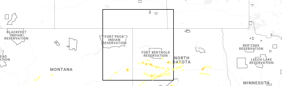
Hail Map for Wibaux, MT
The Wibaux, MT area has had 35 reports of on-the-ground hail by trained spotters, and has been under severe weather warnings 11 times during the past 12 months. Doppler radar has detected hail at or near Wibaux, MT on 25 occasions, including 1 occasion during the past year.
| Name: | Wibaux, MT |
| Where Located: | 84.5 miles SSW of Williston, ND |
| Map: | Google Map for Wibaux, MT |
| Population: | 589 |
| Housing Units: | 308 |
| More Info: | Search Google for Wibaux, MT |
0
The Top Recent Hail Date for Wibaux, MT is Friday, June 20, 2025 (25th out of 25)
Hail and Wind Damage Spotted near Wibaux, MT
| Date / Time | Report Details |
|---|---|
| 6/25/2025 5:48 PM MDT | The storm which prompted the warning has weakened below severe limits, and no longer poses an immediate threat to life or property. therefore, the warning has been allowed to expire. however, small hail and gusty winds are still possible with this thunderstorm. |
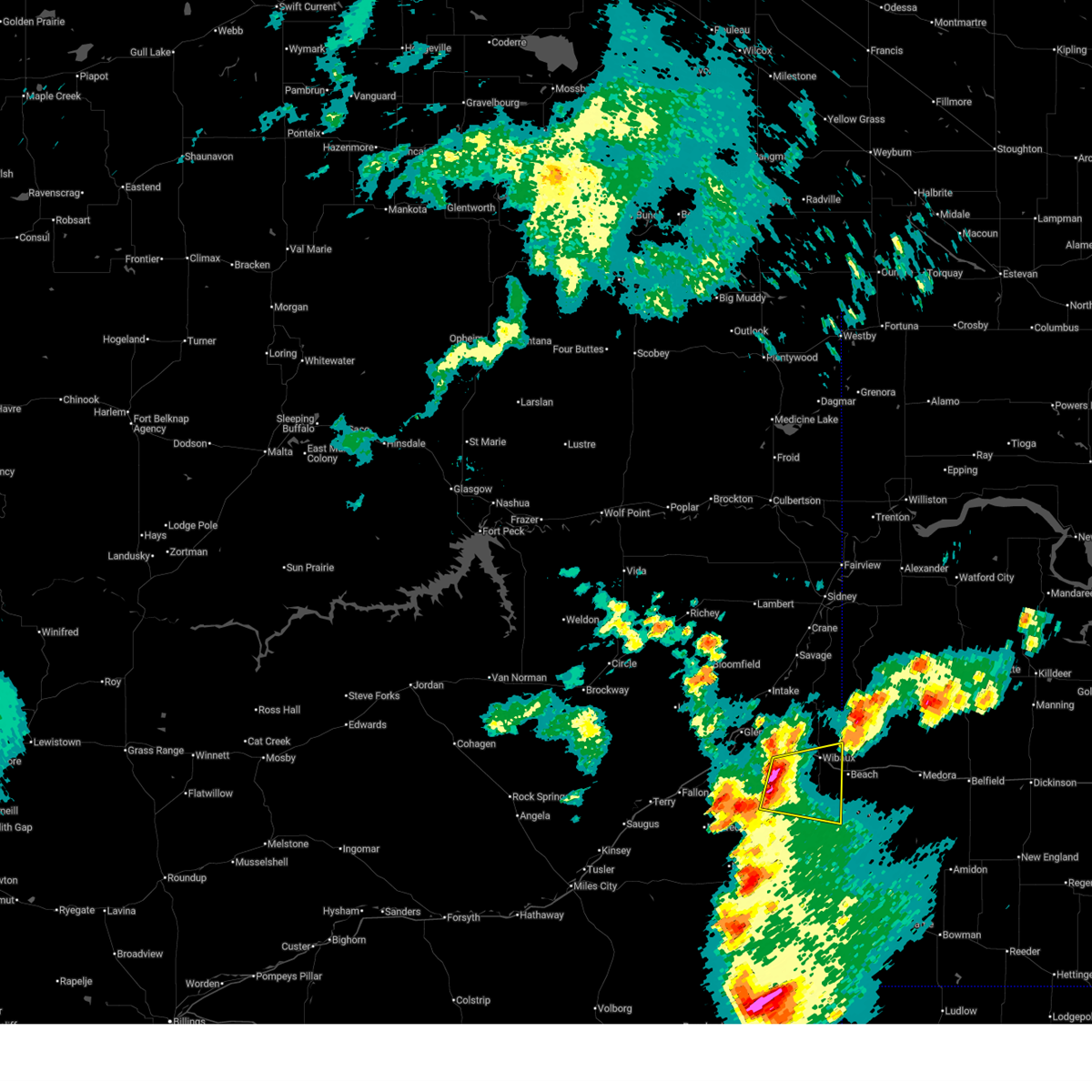
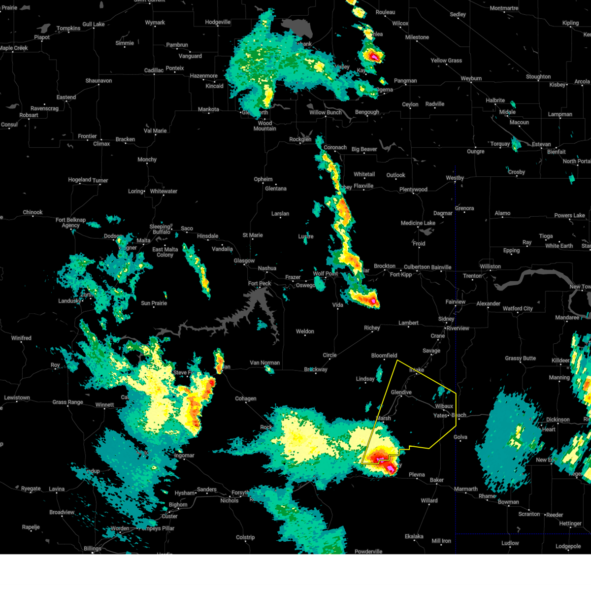
| 6/25/2025 5:14 PM MDT | At 514 pm mdt, a severe thunderstorm was located 11 miles southwest of wibaux, moving east at 15 mph (radar indicated). Hazards include 60 mph wind gusts and quarter size hail. Hail damage to vehicles is expected. expect wind damage to roofs, siding, and trees. Locations impacted include, wibaux, carlyle, hodges, saint phillip, and yates. |
| 6/25/2025 4:44 PM MDT |
 Svrggw the national weather service in glasgow has issued a * severe thunderstorm warning for, wibaux county in northeastern montana, southeastern prairie county in northeastern montana, southeastern dawson county in northeastern montana, * until 545 pm mdt. * at 444 pm mdt, a severe thunderstorm was located 16 miles southwest of wibaux, moving east at 15 mph (radar indicated). Hazards include 60 mph wind gusts and quarter size hail. Hail damage to vehicles is expected. Expect wind damage to roofs, siding, and trees. Svrggw the national weather service in glasgow has issued a * severe thunderstorm warning for, wibaux county in northeastern montana, southeastern prairie county in northeastern montana, southeastern dawson county in northeastern montana, * until 545 pm mdt. * at 444 pm mdt, a severe thunderstorm was located 16 miles southwest of wibaux, moving east at 15 mph (radar indicated). Hazards include 60 mph wind gusts and quarter size hail. Hail damage to vehicles is expected. Expect wind damage to roofs, siding, and trees.
|
| 6/20/2025 5:36 PM MDT |
 the severe thunderstorm warning has been cancelled and is no longer in effect the severe thunderstorm warning has been cancelled and is no longer in effect
|
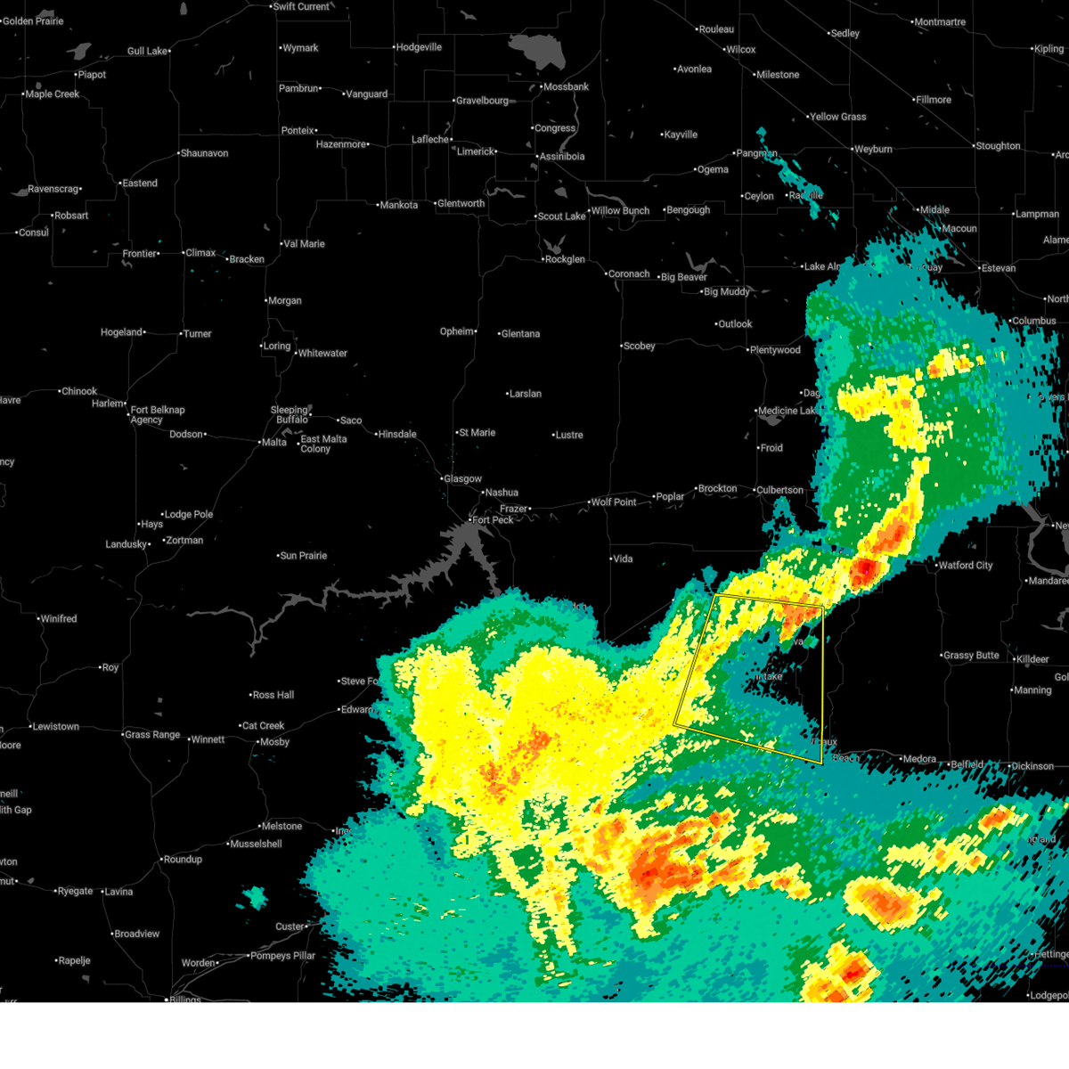
| 6/20/2025 5:27 PM MDT |
 At 527 pm mdt, severe thunderstorms were located along a line extending from near wibaux to 10 miles southwest of beach, moving east at 30 mph (radar indicated). Hazards include 60 mph wind gusts and quarter size hail. Hail damage to vehicles is expected. expect wind damage to roofs, siding, and trees. Locations impacted include, wibaux, saint phillip, and yates. At 527 pm mdt, severe thunderstorms were located along a line extending from near wibaux to 10 miles southwest of beach, moving east at 30 mph (radar indicated). Hazards include 60 mph wind gusts and quarter size hail. Hail damage to vehicles is expected. expect wind damage to roofs, siding, and trees. Locations impacted include, wibaux, saint phillip, and yates.
|
| 6/20/2025 5:27 PM MDT |
 the severe thunderstorm warning has been cancelled and is no longer in effect the severe thunderstorm warning has been cancelled and is no longer in effect
|
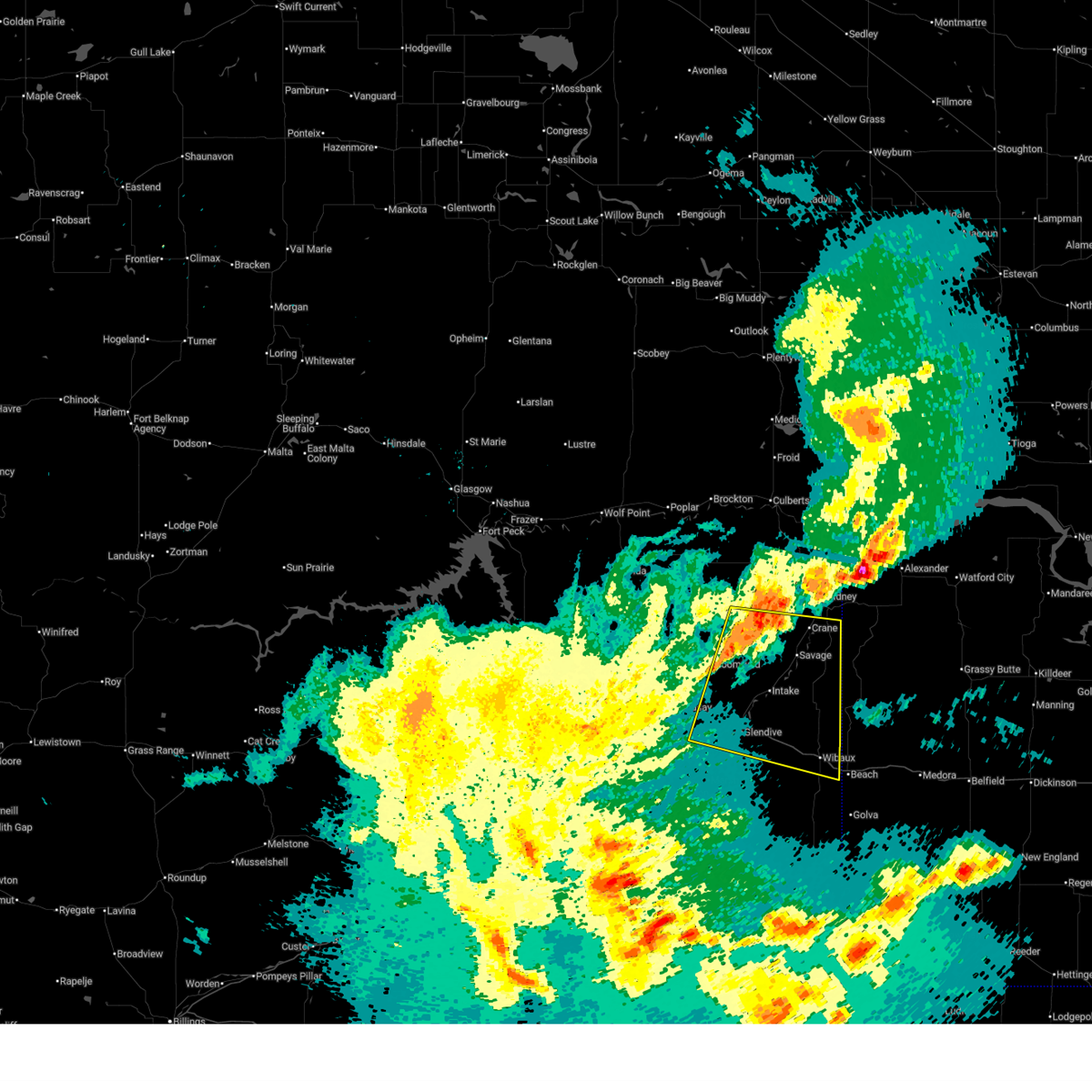
| 6/20/2025 4:57 PM MDT |
 Svrggw the national weather service in glasgow has issued a * severe thunderstorm warning for, southern wibaux county in northeastern montana, southeastern dawson county in northeastern montana, * until 600 pm mdt. * at 456 pm mdt, severe thunderstorms were located along a line extending from 12 miles west of wibaux to 22 miles south of glendive, moving east at 35 mph (radar indicated). Hazards include 60 mph wind gusts and quarter size hail. Hail damage to vehicles is expected. Expect wind damage to roofs, siding, and trees. Svrggw the national weather service in glasgow has issued a * severe thunderstorm warning for, southern wibaux county in northeastern montana, southeastern dawson county in northeastern montana, * until 600 pm mdt. * at 456 pm mdt, severe thunderstorms were located along a line extending from 12 miles west of wibaux to 22 miles south of glendive, moving east at 35 mph (radar indicated). Hazards include 60 mph wind gusts and quarter size hail. Hail damage to vehicles is expected. Expect wind damage to roofs, siding, and trees.
|
| 6/16/2025 12:00 AM MDT | Ash creek mt dot (wibaux county in wibaux county MT, 23.3 miles N of Wibaux, MT |
| 6/15/2025 11:22 PM MDT |
 The storm which prompted the warning has weakened below severe limits, and no longer poses an immediate threat to life or property. therefore, the warning will be allowed to expire. however, gusty winds and heavy rain are still possible with this thunderstorm. a severe thunderstorm watch remains in effect until 100 am mdt for northeastern montana. The storm which prompted the warning has weakened below severe limits, and no longer poses an immediate threat to life or property. therefore, the warning will be allowed to expire. however, gusty winds and heavy rain are still possible with this thunderstorm. a severe thunderstorm watch remains in effect until 100 am mdt for northeastern montana.
|
| 6/15/2025 11:00 PM MDT |
 At 1059 pm mdt, a severe thunderstorm was located near savage, or 24 miles southwest of sidney, moving east at 40 mph (radar indicated). Hazards include 60 mph wind gusts. Expect damage to roofs, siding, and trees. Locations impacted include, hodges, forest park, savage, stipek, glendive, intake, west glendive, midway, burns, crane, yates, and wibaux. At 1059 pm mdt, a severe thunderstorm was located near savage, or 24 miles southwest of sidney, moving east at 40 mph (radar indicated). Hazards include 60 mph wind gusts. Expect damage to roofs, siding, and trees. Locations impacted include, hodges, forest park, savage, stipek, glendive, intake, west glendive, midway, burns, crane, yates, and wibaux.
|
| 6/15/2025 10:22 PM MDT |
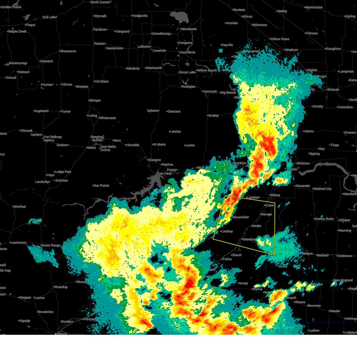 Svrggw the national weather service in glasgow has issued a * severe thunderstorm warning for, northeastern wibaux county in northeastern montana, dawson county in northeastern montana, southern richland county in northeastern montana, * until 1130 pm mdt. * at 1022 pm mdt, a severe thunderstorm was located over bloomfield, or 22 miles northwest of glendive, moving east at 40 mph (radar indicated). Hazards include 70 mph wind gusts. Expect considerable tree damage. Damage is likely to mobile homes, roofs, and outbuildings. Svrggw the national weather service in glasgow has issued a * severe thunderstorm warning for, northeastern wibaux county in northeastern montana, dawson county in northeastern montana, southern richland county in northeastern montana, * until 1130 pm mdt. * at 1022 pm mdt, a severe thunderstorm was located over bloomfield, or 22 miles northwest of glendive, moving east at 40 mph (radar indicated). Hazards include 70 mph wind gusts. Expect considerable tree damage. Damage is likely to mobile homes, roofs, and outbuildings.
|
| 9/12/2024 5:55 PM MDT |
 Svrggw the national weather service in glasgow has issued a * severe thunderstorm warning for, wibaux county in northeastern montana, southeastern prairie county in northeastern montana, southeastern dawson county in northeastern montana, * until 700 pm mdt. * at 554 pm mdt, a severe thunderstorm was located 25 miles southeast of fallon, or 27 miles southeast of terry, moving northeast at 60 mph (radar indicated). Hazards include 70 mph wind gusts and quarter size hail. Hail damage to vehicles is expected. expect considerable tree damage. Wind damage is also likely to mobile homes, roofs, and outbuildings. Svrggw the national weather service in glasgow has issued a * severe thunderstorm warning for, wibaux county in northeastern montana, southeastern prairie county in northeastern montana, southeastern dawson county in northeastern montana, * until 700 pm mdt. * at 554 pm mdt, a severe thunderstorm was located 25 miles southeast of fallon, or 27 miles southeast of terry, moving northeast at 60 mph (radar indicated). Hazards include 70 mph wind gusts and quarter size hail. Hail damage to vehicles is expected. expect considerable tree damage. Wind damage is also likely to mobile homes, roofs, and outbuildings.
|
| 6/27/2024 6:29 PM MDT |
 the severe thunderstorm warning has been cancelled and is no longer in effect the severe thunderstorm warning has been cancelled and is no longer in effect
|
| 6/27/2024 5:47 PM MDT |
 Svrggw the national weather service in glasgow has issued a * severe thunderstorm warning for, eastern wibaux county in northeastern montana, southeastern roosevelt county in northeastern montana, richland county in northeastern montana, northeastern dawson county in northeastern montana, * until 645 pm mdt. * at 547 pm mdt, severe thunderstorms were located along a line extending from 11 miles northwest of lambert to 14 miles northwest of carlyle, moving northeast at 35 mph (radar indicated). Hazards include 70 mph wind gusts and half dollar size hail. Hail damage to vehicles is expected. expect considerable tree damage. Wind damage is also likely to mobile homes, roofs, and outbuildings. Svrggw the national weather service in glasgow has issued a * severe thunderstorm warning for, eastern wibaux county in northeastern montana, southeastern roosevelt county in northeastern montana, richland county in northeastern montana, northeastern dawson county in northeastern montana, * until 645 pm mdt. * at 547 pm mdt, severe thunderstorms were located along a line extending from 11 miles northwest of lambert to 14 miles northwest of carlyle, moving northeast at 35 mph (radar indicated). Hazards include 70 mph wind gusts and half dollar size hail. Hail damage to vehicles is expected. expect considerable tree damage. Wind damage is also likely to mobile homes, roofs, and outbuildings.
|
| 6/22/2024 4:47 PM MDT |
 The storm which prompted the warning has moved out of the area. therefore, the warning has been allowed to expire. The storm which prompted the warning has moved out of the area. therefore, the warning has been allowed to expire.
|
| 6/22/2024 3:43 PM MDT |
 Svrggw the national weather service in glasgow has issued a * severe thunderstorm warning for, southern wibaux county in northeastern montana, east central prairie county in northeastern montana, southeastern dawson county in northeastern montana, * until 445 pm mdt. * at 342 pm mdt, a severe thunderstorm was located 12 miles southeast of glendive, moving east at 25 mph (radar indicated). Hazards include 60 mph wind gusts and half dollar size hail. Hail damage to vehicles is expected. Expect wind damage to roofs, siding, and trees. Svrggw the national weather service in glasgow has issued a * severe thunderstorm warning for, southern wibaux county in northeastern montana, east central prairie county in northeastern montana, southeastern dawson county in northeastern montana, * until 445 pm mdt. * at 342 pm mdt, a severe thunderstorm was located 12 miles southeast of glendive, moving east at 25 mph (radar indicated). Hazards include 60 mph wind gusts and half dollar size hail. Hail damage to vehicles is expected. Expect wind damage to roofs, siding, and trees.
|
| 6/15/2024 8:57 PM MDT |
 The storm which prompted the warning has weakened below severe limits, and no longer poses an immediate threat to life or property. therefore, the warning will be allowed to expire. however, gusty winds are still possible with this thunderstorm. The storm which prompted the warning has weakened below severe limits, and no longer poses an immediate threat to life or property. therefore, the warning will be allowed to expire. however, gusty winds are still possible with this thunderstorm.
|
| 6/15/2024 8:29 PM MDT |
 At 829 pm mdt, a severe thunderstorm was located near intake, or 9 miles northeast of glendive, moving east at 30 mph (radar indicated). Hazards include 60 mph wind gusts. Expect damage to roofs, siding, and trees. Locations impacted include, glendive, wibaux, intake, west glendive, hoyt, hodges, forest park, stipek, burns, and yates. At 829 pm mdt, a severe thunderstorm was located near intake, or 9 miles northeast of glendive, moving east at 30 mph (radar indicated). Hazards include 60 mph wind gusts. Expect damage to roofs, siding, and trees. Locations impacted include, glendive, wibaux, intake, west glendive, hoyt, hodges, forest park, stipek, burns, and yates.
|
| 6/15/2024 8:02 PM MDT |
 Svrggw the national weather service in glasgow has issued a * severe thunderstorm warning for, northern wibaux county in northeastern montana, southeastern richland county in northeastern montana, southern dawson county in northeastern montana, * until 900 pm mdt. * at 802 pm mdt, a severe thunderstorm was located 9 miles south of bloomfield, or 14 miles northwest of glendive, moving east at 30 mph (radar indicated). Hazards include 60 mph wind gusts. expect damage to roofs, siding, and trees Svrggw the national weather service in glasgow has issued a * severe thunderstorm warning for, northern wibaux county in northeastern montana, southeastern richland county in northeastern montana, southern dawson county in northeastern montana, * until 900 pm mdt. * at 802 pm mdt, a severe thunderstorm was located 9 miles south of bloomfield, or 14 miles northwest of glendive, moving east at 30 mph (radar indicated). Hazards include 60 mph wind gusts. expect damage to roofs, siding, and trees
|
| 8/23/2023 12:02 AM MDT |
 At 1202 am mdt, severe thunderstorms were located along a line extending from 9 miles southwest of sidney to near trotters to near beach, moving northeast at 45 mph (radar indicated). Hazards include 60 mph wind gusts. Expect damage to roofs, siding, and trees. locations impacted include, wibaux, savage, intake, hodges, stipek, midway, burns, crane, and yates. hail threat, radar indicated max hail size, <. 75 in wind threat, observed max wind gust, 60 mph. At 1202 am mdt, severe thunderstorms were located along a line extending from 9 miles southwest of sidney to near trotters to near beach, moving northeast at 45 mph (radar indicated). Hazards include 60 mph wind gusts. Expect damage to roofs, siding, and trees. locations impacted include, wibaux, savage, intake, hodges, stipek, midway, burns, crane, and yates. hail threat, radar indicated max hail size, <. 75 in wind threat, observed max wind gust, 60 mph.
|
| 8/22/2023 11:40 PM MDT |
 At 1139 pm mdt, severe thunderstorms were located along a line extending from 12 miles west of savage to 15 miles southeast of intake to 12 miles south of wibaux, moving northeast at 45 mph (radar indicated). Hazards include 60 mph wind gusts. expect damage to roofs, siding, and trees At 1139 pm mdt, severe thunderstorms were located along a line extending from 12 miles west of savage to 15 miles southeast of intake to 12 miles south of wibaux, moving northeast at 45 mph (radar indicated). Hazards include 60 mph wind gusts. expect damage to roofs, siding, and trees
|
| 7/11/2023 5:44 PM MDT |
 At 540 pm mdt, a severe thunderstorm was located 9 miles southwest of west glendive, or 10 miles southwest of glendive, moving southeast at 35 mph. a second severe thunderstorm is located south of saint phillip and moving to the southeast at 35 mph (radar indicated). Hazards include ping pong ball size hail and 60 mph wind gusts. People and animals outdoors will be injured. expect hail damage to roofs, siding, windows, and vehicles. Expect wind damage to roofs, siding, and trees. At 540 pm mdt, a severe thunderstorm was located 9 miles southwest of west glendive, or 10 miles southwest of glendive, moving southeast at 35 mph. a second severe thunderstorm is located south of saint phillip and moving to the southeast at 35 mph (radar indicated). Hazards include ping pong ball size hail and 60 mph wind gusts. People and animals outdoors will be injured. expect hail damage to roofs, siding, windows, and vehicles. Expect wind damage to roofs, siding, and trees.
|
| 7/11/2023 5:31 PM MDT | Tea Cup sized hail reported 19.9 miles NNE of Wibaux, MT, spotter reported a hail stone of 3 inches embedded within a field of 1 inch sized hail. |
| 7/11/2023 5:24 PM MDT | Reported at the pine hills raws sit in wibaux county MT, 23.3 miles NE of Wibaux, MT |
| 7/11/2023 5:14 PM MDT |
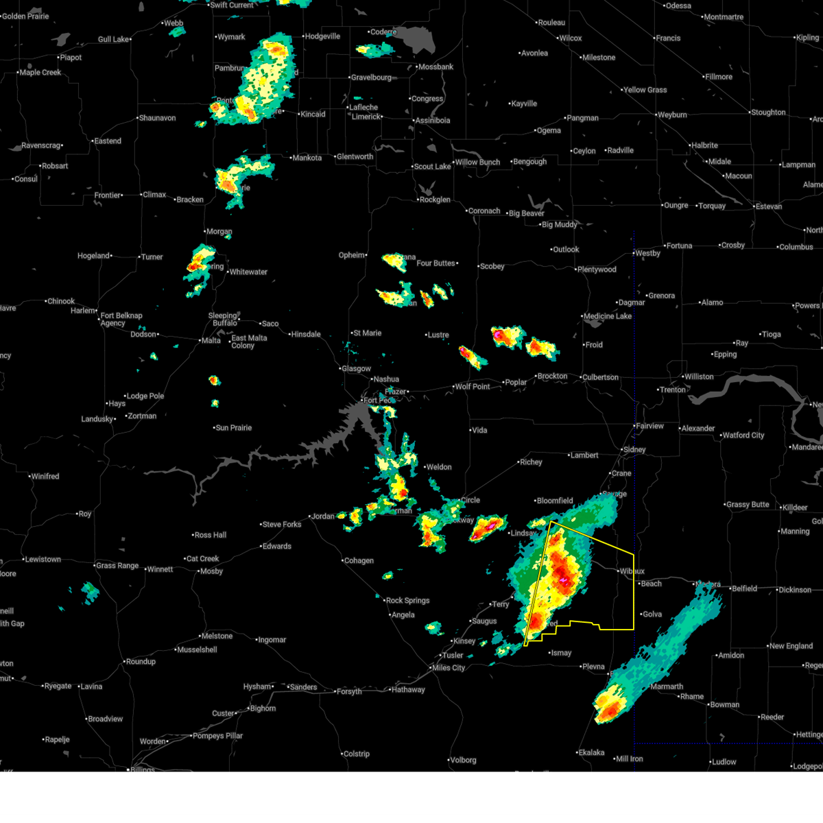
 At 513 pm mdt, a severe thunderstorm was located 8 miles southwest of wibaux, moving east at 40 mph (radar indicated). Hazards include ping pong ball size hail and 60 mph wind gusts. People and animals outdoors will be injured. expect hail damage to roofs, siding, windows, and vehicles. expect wind damage to roofs, siding, and trees. locations impacted include, glendive, wibaux, west glendive, carlyle, hoyt, hodges, forest park, stipek, marsh, saint phillip and yates. hail threat, radar indicated max hail size, 1. 50 in wind threat, radar indicated max wind gust, 60 mph. At 513 pm mdt, a severe thunderstorm was located 8 miles southwest of wibaux, moving east at 40 mph (radar indicated). Hazards include ping pong ball size hail and 60 mph wind gusts. People and animals outdoors will be injured. expect hail damage to roofs, siding, windows, and vehicles. expect wind damage to roofs, siding, and trees. locations impacted include, glendive, wibaux, west glendive, carlyle, hoyt, hodges, forest park, stipek, marsh, saint phillip and yates. hail threat, radar indicated max hail size, 1. 50 in wind threat, radar indicated max wind gust, 60 mph.
|
| 7/11/2023 4:41 PM MDT |
 At 440 pm mdt, a severe thunderstorm was located 9 miles south of west glendive, or 9 miles south of glendive, moving southeast at 40 mph (radar indicated). Hazards include 60 mph wind gusts and half dollar size hail. Hail damage to vehicles is expected. Expect wind damage to roofs, siding, and trees. At 440 pm mdt, a severe thunderstorm was located 9 miles south of west glendive, or 9 miles south of glendive, moving southeast at 40 mph (radar indicated). Hazards include 60 mph wind gusts and half dollar size hail. Hail damage to vehicles is expected. Expect wind damage to roofs, siding, and trees.
|
| 6/8/2023 5:56 PM MDT |
 The severe thunderstorm warning for east central wibaux county will expire at 600 pm mdt, the storm which prompted the warning has weakened below severe limits, and has exited the warned area. therefore, the warning will be allowed to expire. however small hail and heavy rain are still possible with this thunderstorm. The severe thunderstorm warning for east central wibaux county will expire at 600 pm mdt, the storm which prompted the warning has weakened below severe limits, and has exited the warned area. therefore, the warning will be allowed to expire. however small hail and heavy rain are still possible with this thunderstorm.
|
| 6/8/2023 5:38 PM MDT |
 At 538 pm mdt, a severe thunderstorm was located over wibaux, and is nearly stationary (radar indicated). Hazards include 60 mph wind gusts and quarter size hail. Hail damage to vehicles is expected. expect wind damage to roofs, siding, and trees. locations impacted include, wibaux. hail threat, radar indicated max hail size, 1. 00 in wind threat, radar indicated max wind gust, 60 mph. At 538 pm mdt, a severe thunderstorm was located over wibaux, and is nearly stationary (radar indicated). Hazards include 60 mph wind gusts and quarter size hail. Hail damage to vehicles is expected. expect wind damage to roofs, siding, and trees. locations impacted include, wibaux. hail threat, radar indicated max hail size, 1. 00 in wind threat, radar indicated max wind gust, 60 mph.
|
| 6/8/2023 5:30 PM MDT | Half Dollar sized hail reported 5.6 miles ESE of Wibaux, MT, hail up to the size of half dollars lasted for 20 minutes (5:30 pm to 5:50 pm). |
| 6/8/2023 5:05 PM MDT | Quarter sized hail reported 2.6 miles NNW of Wibaux, MT, hail up to the size of quarters. |
| 6/8/2023 5:03 PM MDT |
 At 503 pm mdt, a severe thunderstorm was located over wibaux, and is nearly stationary (radar indicated). Hazards include 60 mph wind gusts and quarter size hail. Hail damage to vehicles is expected. Expect wind damage to roofs, siding, and trees. At 503 pm mdt, a severe thunderstorm was located over wibaux, and is nearly stationary (radar indicated). Hazards include 60 mph wind gusts and quarter size hail. Hail damage to vehicles is expected. Expect wind damage to roofs, siding, and trees.
|
| 5/27/2023 6:55 PM MDT |
 The severe thunderstorm warning for wibaux and southeastern dawson counties will expire at 700 pm mdt, the storm which prompted the warning has weakened below severe limits, and no longer poses an immediate threat to life or property. therefore, the warning will be allowed to expire. however heavy rain is still possible with this thunderstorm. The severe thunderstorm warning for wibaux and southeastern dawson counties will expire at 700 pm mdt, the storm which prompted the warning has weakened below severe limits, and no longer poses an immediate threat to life or property. therefore, the warning will be allowed to expire. however heavy rain is still possible with this thunderstorm.
|
| 5/27/2023 6:29 PM MDT |
 At 626 pm mdt, a severe thunderstorm was located over wibaux, moving north at 30 mph (radar indicated). Hazards include 60 mph wind gusts and quarter size hail. Hail damage to vehicles is expected. expect wind damage to roofs, siding, and trees. locations impacted include, wibaux, carlyle, hodges, saint phillip and yates. hail threat, radar indicated max hail size, 1. 00 in wind threat, radar indicated max wind gust, 60 mph. At 626 pm mdt, a severe thunderstorm was located over wibaux, moving north at 30 mph (radar indicated). Hazards include 60 mph wind gusts and quarter size hail. Hail damage to vehicles is expected. expect wind damage to roofs, siding, and trees. locations impacted include, wibaux, carlyle, hodges, saint phillip and yates. hail threat, radar indicated max hail size, 1. 00 in wind threat, radar indicated max wind gust, 60 mph.
|
| 5/27/2023 6:01 PM MDT |
 At 601 pm mdt, a severe thunderstorm was located 10 miles northwest of golva, or 10 miles southwest of beach, moving north at 30 mph (radar indicated). Hazards include 60 mph wind gusts and quarter size hail. Hail damage to vehicles is expected. Expect wind damage to roofs, siding, and trees. At 601 pm mdt, a severe thunderstorm was located 10 miles northwest of golva, or 10 miles southwest of beach, moving north at 30 mph (radar indicated). Hazards include 60 mph wind gusts and quarter size hail. Hail damage to vehicles is expected. Expect wind damage to roofs, siding, and trees.
|
| 5/27/2023 5:50 PM MDT | Quarter sized hail reported 22.6 miles N of Wibaux, MT, heavy downpours along with hail up to the size of quarters. |
| 5/27/2023 5:30 PM MDT |
 At 528 pm mdt, a severe thunderstorm was located 15 miles southeast of glendive, moving north at 30 mph (radar indicated). Hazards include 60 mph wind gusts and half dollar size hail. Hail damage to vehicles is expected. expect wind damage to roofs, siding, and trees. locations impacted include, glendive, wibaux, intake, west glendive, carlyle, hoyt, hodges, forest park, stipek, saint phillip and yates. hail threat, radar indicated max hail size, 1. 25 in wind threat, radar indicated max wind gust, 60 mph. At 528 pm mdt, a severe thunderstorm was located 15 miles southeast of glendive, moving north at 30 mph (radar indicated). Hazards include 60 mph wind gusts and half dollar size hail. Hail damage to vehicles is expected. expect wind damage to roofs, siding, and trees. locations impacted include, glendive, wibaux, intake, west glendive, carlyle, hoyt, hodges, forest park, stipek, saint phillip and yates. hail threat, radar indicated max hail size, 1. 25 in wind threat, radar indicated max wind gust, 60 mph.
|
| 5/27/2023 5:05 PM MDT |
 At 505 pm mdt, a severe thunderstorm was located 21 miles west of carlyle, or 21 miles northwest of baker, moving north at 50 mph (radar indicated). Hazards include 60 mph wind gusts and half dollar size hail. Hail damage to vehicles is expected. Expect wind damage to roofs, siding, and trees. At 505 pm mdt, a severe thunderstorm was located 21 miles west of carlyle, or 21 miles northwest of baker, moving north at 50 mph (radar indicated). Hazards include 60 mph wind gusts and half dollar size hail. Hail damage to vehicles is expected. Expect wind damage to roofs, siding, and trees.
|
| 7/15/2022 9:51 PM MDT |
 The severe thunderstorm warning for wibaux, east central prairie and southeastern dawson counties will expire at 1000 pm mdt, the storm which prompted the warning has weakened below severe limits, and no longer poses an immediate threat to life or property. therefore, the warning will be allowed to expire. however gusty winds are still possible with this thunderstorm. The severe thunderstorm warning for wibaux, east central prairie and southeastern dawson counties will expire at 1000 pm mdt, the storm which prompted the warning has weakened below severe limits, and no longer poses an immediate threat to life or property. therefore, the warning will be allowed to expire. however gusty winds are still possible with this thunderstorm.
|
| 7/15/2022 9:26 PM MDT |
 At 926 pm mdt, a severe thunderstorm was located 18 miles southwest of wibaux, moving northeast at 30 mph (radar indicated). Hazards include 60 mph wind gusts and quarter size hail. Hail damage to vehicles is expected. expect wind damage to roofs, siding, and trees. locations impacted include, wibaux, carlyle, hodges, saint phillip and yates. hail threat, radar indicated max hail size, 1. 00 in wind threat, radar indicated max wind gust, 60 mph. At 926 pm mdt, a severe thunderstorm was located 18 miles southwest of wibaux, moving northeast at 30 mph (radar indicated). Hazards include 60 mph wind gusts and quarter size hail. Hail damage to vehicles is expected. expect wind damage to roofs, siding, and trees. locations impacted include, wibaux, carlyle, hodges, saint phillip and yates. hail threat, radar indicated max hail size, 1. 00 in wind threat, radar indicated max wind gust, 60 mph.
|
| 7/15/2022 9:04 PM MDT |
 At 904 pm mdt, a severe thunderstorm was located 25 miles west of carlyle, or 27 miles northwest of baker, moving northeast at 30 mph (radar indicated). Hazards include 60 mph wind gusts and quarter size hail. Hail damage to vehicles is expected. Expect wind damage to roofs, siding, and trees. At 904 pm mdt, a severe thunderstorm was located 25 miles west of carlyle, or 27 miles northwest of baker, moving northeast at 30 mph (radar indicated). Hazards include 60 mph wind gusts and quarter size hail. Hail damage to vehicles is expected. Expect wind damage to roofs, siding, and trees.
|
| 7/10/2022 1:04 AM MDT |
 At 104 am mdt, severe thunderstorms were located along a line extending from near sentinel butte to 8 miles north of marmarth, moving east at 70 mph (radar indicated). Hazards include 70 mph wind gusts and half dollar size hail. Hail damage to vehicles is expected. expect considerable tree damage. wind damage is also likely to mobile homes, roofs, and outbuildings. locations impacted include, wibaux, intake, carlyle, hodges, saint phillip and yates. thunderstorm damage threat, considerable hail threat, observed max hail size, 1. 25 in wind threat, observed max wind gust, 70 mph. At 104 am mdt, severe thunderstorms were located along a line extending from near sentinel butte to 8 miles north of marmarth, moving east at 70 mph (radar indicated). Hazards include 70 mph wind gusts and half dollar size hail. Hail damage to vehicles is expected. expect considerable tree damage. wind damage is also likely to mobile homes, roofs, and outbuildings. locations impacted include, wibaux, intake, carlyle, hodges, saint phillip and yates. thunderstorm damage threat, considerable hail threat, observed max hail size, 1. 25 in wind threat, observed max wind gust, 70 mph.
|
| 7/10/2022 12:47 AM MDT |
 At 1247 am mdt, severe thunderstorms were located along a line extending from 8 miles southwest of wibaux to near baker, moving east at 50 mph (radar indicated). Hazards include 70 mph wind gusts and half dollar size hail. Hail damage to vehicles is expected. expect considerable tree damage. wind damage is also likely to mobile homes, roofs, and outbuildings. locations impacted include, glendive, wibaux, west glendive, intake, carlyle, hoyt, saint phillip, yates, hodges, mildred, forest park, stipek and marsh. thunderstorm damage threat, considerable hail threat, observed max hail size, 1. 25 in wind threat, observed max wind gust, 70 mph. At 1247 am mdt, severe thunderstorms were located along a line extending from 8 miles southwest of wibaux to near baker, moving east at 50 mph (radar indicated). Hazards include 70 mph wind gusts and half dollar size hail. Hail damage to vehicles is expected. expect considerable tree damage. wind damage is also likely to mobile homes, roofs, and outbuildings. locations impacted include, glendive, wibaux, west glendive, intake, carlyle, hoyt, saint phillip, yates, hodges, mildred, forest park, stipek and marsh. thunderstorm damage threat, considerable hail threat, observed max hail size, 1. 25 in wind threat, observed max wind gust, 70 mph.
|
| 7/10/2022 12:24 AM MDT |
 At 1222 am mdt, severe thunderstorms were located along a line extending from 13 miles east of fallon to 27 miles west of baker, moving east at 70 mph (radar indicated). Hazards include 70 mph wind gusts and half dollar size hail. Hail damage to vehicles is expected. expect considerable tree damage. Wind damage is also likely to mobile homes, roofs, and outbuildings. At 1222 am mdt, severe thunderstorms were located along a line extending from 13 miles east of fallon to 27 miles west of baker, moving east at 70 mph (radar indicated). Hazards include 70 mph wind gusts and half dollar size hail. Hail damage to vehicles is expected. expect considerable tree damage. Wind damage is also likely to mobile homes, roofs, and outbuildings.
|
| 7/9/2022 11:48 PM MDT |
 At 1148 pm mdt, severe thunderstorms were located along a line extending from 13 miles southwest of richey to 12 miles south of terry, moving east at 60 mph (radar indicated). Hazards include 70 mph wind gusts and half dollar size hail. Hail damage to vehicles is expected. expect considerable tree damage. wind damage is also likely to mobile homes, roofs, and outbuildings. locations impacted include, sidney, glendive, terry, wibaux, fallon, fairview, richey, savage, west glendive, intake, bloomfield, lambert, carlyle, lindsay, east fairview, enid, wooley, crane, mildred and calypso. thunderstorm damage threat, considerable hail threat, radar indicated max hail size, 1. 25 in wind threat, radar indicated max wind gust, 70 mph. At 1148 pm mdt, severe thunderstorms were located along a line extending from 13 miles southwest of richey to 12 miles south of terry, moving east at 60 mph (radar indicated). Hazards include 70 mph wind gusts and half dollar size hail. Hail damage to vehicles is expected. expect considerable tree damage. wind damage is also likely to mobile homes, roofs, and outbuildings. locations impacted include, sidney, glendive, terry, wibaux, fallon, fairview, richey, savage, west glendive, intake, bloomfield, lambert, carlyle, lindsay, east fairview, enid, wooley, crane, mildred and calypso. thunderstorm damage threat, considerable hail threat, radar indicated max hail size, 1. 25 in wind threat, radar indicated max wind gust, 70 mph.
|
| 7/9/2022 11:27 PM MDT |
 At 1126 pm mdt, severe thunderstorms were located along a line extending from 10 miles northwest of circle to 15 miles north of miles city, moving east at 60 mph (radar indicated). Hazards include 70 mph wind gusts and half dollar size hail. Hail damage to vehicles is expected. expect considerable tree damage. Wind damage is also likely to mobile homes, roofs, and outbuildings. At 1126 pm mdt, severe thunderstorms were located along a line extending from 10 miles northwest of circle to 15 miles north of miles city, moving east at 60 mph (radar indicated). Hazards include 70 mph wind gusts and half dollar size hail. Hail damage to vehicles is expected. expect considerable tree damage. Wind damage is also likely to mobile homes, roofs, and outbuildings.
|
| 7/9/2022 10:30 PM MDT |
 At 1030 pm mdt, severe thunderstorms were located along a line extending from 11 miles southwest of vida to 14 miles west of terry, moving east at 60 mph (radar indicated). Hazards include 70 mph wind gusts and half dollar size hail. Hail damage to vehicles is expected. expect considerable tree damage. Wind damage is also likely to mobile homes, roofs, and outbuildings. At 1030 pm mdt, severe thunderstorms were located along a line extending from 11 miles southwest of vida to 14 miles west of terry, moving east at 60 mph (radar indicated). Hazards include 70 mph wind gusts and half dollar size hail. Hail damage to vehicles is expected. expect considerable tree damage. Wind damage is also likely to mobile homes, roofs, and outbuildings.
|
| 7/9/2022 1:41 AM MDT | At 140 am mdt, severe thunderstorms were located along a line extending from 6 miles southeast of bonetrail to 7 miles southwest of beach, moving east at 45 mph (radar indicated). Hazards include 60 mph wind gusts and quarter size hail. Hail damage to vehicles is expected. expect wind damage to roofs, siding, and trees. locations impacted include, sidney, wibaux, fairview, hodges, snowden, saint phillip, nohly, wooley and yates. hail threat, radar indicated max hail size, 1. 00 in wind threat, radar indicated max wind gust, 60 mph. |
| 7/9/2022 1:23 AM MDT | At 123 am mdt, severe thunderstorms were located along a line extending from 9 miles southwest of bonetrail to 17 miles southwest of wibaux, moving east at 50 mph (radar indicated). Hazards include 60 mph wind gusts and quarter size hail. Hail damage to vehicles is expected. Expect wind damage to roofs, siding, and trees. |
| 7/9/2022 1:09 AM MDT | At 108 am mdt, severe thunderstorms were located along a line extending from 8 miles north of archer to 7 miles east of richey, moving east at 70 mph (radar indicated). Hazards include 60 mph wind gusts and penny size hail. Expect damage to roofs, siding, and trees. locations impacted include, sidney, glendive, plentywood, culbertson, wibaux, fairview, medicine lake, bainville, froid, westby, port of raymond, savage, west glendive, intake, lambert, reserve, raymond, enid, comertown and nohly. hail threat, radar indicated max hail size, 0. 75 in wind threat, observed max wind gust, 60 mph. |
| 7/9/2022 12:53 AM MDT | At 1252 am mdt, severe thunderstorms were located along a line extending from 6 miles north of redstone to near richey, moving east at 60 mph (radar indicated). Hazards include 60 mph wind gusts and nickel size hail. Expect considerable tree damage. damage is likely to mobile homes, roofs, and outbuildings. locations impacted include, sidney, glendive, plentywood, poplar, culbertson, wibaux, fairview, brockton, medicine lake, bainville, froid, richey, westby, archer, port of raymond, savage, west glendive, intake, bloomfield and lambert. thunderstorm damage threat, considerable hail threat, radar indicated max hail size, 0. 88 in wind threat, observed max wind gust, 70 mph. |
| 7/9/2022 12:38 AM MDT | At 1237 am mdt, severe thunderstorms were located along a line extending from 6 miles north of redstone to richey, moving east at 70 mph (radar indicated). Hazards include 60 mph wind gusts and nickel size hail. expect damage to roofs, siding, and trees |
| 7/3/2022 9:24 PM MDT |
 The severe thunderstorm warning for wibaux and southeastern richland counties will expire at 930 pm mdt, the storms which prompted the warning have moved out of the area. therefore, the warning will be allowed to expire. however heavy rain is still possible with these thunderstorms. a severe thunderstorm watch remains in effect until 1100 pm mdt for northeastern montana. The severe thunderstorm warning for wibaux and southeastern richland counties will expire at 930 pm mdt, the storms which prompted the warning have moved out of the area. therefore, the warning will be allowed to expire. however heavy rain is still possible with these thunderstorms. a severe thunderstorm watch remains in effect until 1100 pm mdt for northeastern montana.
|
| 7/3/2022 9:12 PM MDT |
 At 912 pm mdt, severe thunderstorms were located along a line extending from 12 miles southeast of sidney to near golva, moving east at 35 mph (radar indicated). Hazards include 70 mph wind gusts. Expect considerable tree damage. damage is likely to mobile homes, roofs, and outbuildings. locations impacted include, wibaux, carlyle, skaar, saint phillip, midway, crane and yates. thunderstorm damage threat, considerable hail threat, radar indicated max hail size, <. 75 in wind threat, radar indicated max wind gust, 70 mph. At 912 pm mdt, severe thunderstorms were located along a line extending from 12 miles southeast of sidney to near golva, moving east at 35 mph (radar indicated). Hazards include 70 mph wind gusts. Expect considerable tree damage. damage is likely to mobile homes, roofs, and outbuildings. locations impacted include, wibaux, carlyle, skaar, saint phillip, midway, crane and yates. thunderstorm damage threat, considerable hail threat, radar indicated max hail size, <. 75 in wind threat, radar indicated max wind gust, 70 mph.
|
| 7/3/2022 8:53 PM MDT |
 At 852 pm mdt, severe thunderstorms were located along a line extending from 7 miles northeast of savage to 10 miles west of carlyle, moving east at 35 mph (radar indicated). Hazards include 70 mph wind gusts. Expect considerable tree damage. Damage is likely to mobile homes, roofs, and outbuildings. At 852 pm mdt, severe thunderstorms were located along a line extending from 7 miles northeast of savage to 10 miles west of carlyle, moving east at 35 mph (radar indicated). Hazards include 70 mph wind gusts. Expect considerable tree damage. Damage is likely to mobile homes, roofs, and outbuildings.
|
| 7/3/2022 8:27 PM MDT |
 At 826 pm mdt, severe thunderstorms were located along a line extending from near intake to 21 miles west of carlyle, moving east at 45 mph (radar indicated). Hazards include 60 mph wind gusts and quarter size hail. Hail damage to vehicles is expected. expect wind damage to roofs, siding, and trees. locations impacted include, glendive, wibaux, intake, carlyle, hoyt, saint phillip, yates, hodges, mildred, stipek and marsh. hail threat, radar indicated max hail size, 1. 00 in wind threat, radar indicated max wind gust, 60 mph. At 826 pm mdt, severe thunderstorms were located along a line extending from near intake to 21 miles west of carlyle, moving east at 45 mph (radar indicated). Hazards include 60 mph wind gusts and quarter size hail. Hail damage to vehicles is expected. expect wind damage to roofs, siding, and trees. locations impacted include, glendive, wibaux, intake, carlyle, hoyt, saint phillip, yates, hodges, mildred, stipek and marsh. hail threat, radar indicated max hail size, 1. 00 in wind threat, radar indicated max wind gust, 60 mph.
|
| 7/3/2022 7:54 PM MDT |
 At 753 pm mdt, severe thunderstorms were located along a line extending from near bloomfield to 20 miles southeast of fallon, moving east at 40 mph (radar indicated). Hazards include 70 mph wind gusts and half dollar size hail. Hail damage to vehicles is expected. expect considerable tree damage. Wind damage is also likely to mobile homes, roofs, and outbuildings. At 753 pm mdt, severe thunderstorms were located along a line extending from near bloomfield to 20 miles southeast of fallon, moving east at 40 mph (radar indicated). Hazards include 70 mph wind gusts and half dollar size hail. Hail damage to vehicles is expected. expect considerable tree damage. Wind damage is also likely to mobile homes, roofs, and outbuildings.
|
| 7/3/2022 7:26 PM MDT |
 At 726 pm mdt, severe thunderstorms were located along a line extending from near richey to 7 miles south of bloomfield to 16 miles southeast of fallon, moving east at 30 mph (radar indicated). Hazards include 70 mph wind gusts and half dollar size hail. Hail damage to vehicles is expected. expect considerable tree damage. wind damage is also likely to mobile homes, roofs, and outbuildings. Locations impacted include, sidney, glendive, terry, wibaux, fallon, richey, savage, west glendive, intake, bloomfield, lambert, carlyle, lindsay, enid, wooley, crane, mildred, midway, hoyt and saint phillip. At 726 pm mdt, severe thunderstorms were located along a line extending from near richey to 7 miles south of bloomfield to 16 miles southeast of fallon, moving east at 30 mph (radar indicated). Hazards include 70 mph wind gusts and half dollar size hail. Hail damage to vehicles is expected. expect considerable tree damage. wind damage is also likely to mobile homes, roofs, and outbuildings. Locations impacted include, sidney, glendive, terry, wibaux, fallon, richey, savage, west glendive, intake, bloomfield, lambert, carlyle, lindsay, enid, wooley, crane, mildred, midway, hoyt and saint phillip.
|
| 7/3/2022 7:01 PM MDT |
 At 701 pm mdt, severe thunderstorms were located along a line extending from near vida to 6 miles northeast of lindsay to 13 miles west of west glendive, moving northeast at 45 mph (radar indicated). Hazards include 60 mph wind gusts and quarter size hail. Hail damage to vehicles is expected. Expect wind damage to roofs, siding, and trees. At 701 pm mdt, severe thunderstorms were located along a line extending from near vida to 6 miles northeast of lindsay to 13 miles west of west glendive, moving northeast at 45 mph (radar indicated). Hazards include 60 mph wind gusts and quarter size hail. Hail damage to vehicles is expected. Expect wind damage to roofs, siding, and trees.
|
| 7/2/2022 6:35 PM MDT |
 The severe thunderstorm warning for east central wibaux county will expire at 645 pm mdt, the storm which prompted the warning has moved out of the area. therefore, the warning will be allowed to expire. a severe thunderstorm watch remains in effect until 900 pm mdt for northeastern montana. The severe thunderstorm warning for east central wibaux county will expire at 645 pm mdt, the storm which prompted the warning has moved out of the area. therefore, the warning will be allowed to expire. a severe thunderstorm watch remains in effect until 900 pm mdt for northeastern montana.
|
| 7/2/2022 6:30 PM MDT | Quarter sized hail reported 1.8 miles N of Wibaux, MT, quarter sized hail. |
| 7/2/2022 6:18 PM MDT | Quarter sized hail reported 7.3 miles NW of Wibaux, MT |
| 7/2/2022 6:16 PM MDT |
 At 615 pm mdt, a severe thunderstorm was located near beach, moving east at 15 mph (trained weather spotters). Hazards include 60 mph wind gusts and quarter size hail. Hail damage to vehicles is expected. Expect wind damage to roofs, siding, and trees. At 615 pm mdt, a severe thunderstorm was located near beach, moving east at 15 mph (trained weather spotters). Hazards include 60 mph wind gusts and quarter size hail. Hail damage to vehicles is expected. Expect wind damage to roofs, siding, and trees.
|
| 7/2/2022 6:10 PM MDT | Quarter sized hail reported 2.6 miles NNW of Wibaux, MT, lots of quarter sized hail. |
| 7/2/2022 6:00 PM MDT | Quarter sized hail reported 1.8 miles N of Wibaux, MT, corrects previous hail report from 2 s wibaux. quarter sized hail. report corrected to show the correct time. |
| 6/20/2022 6:24 PM MDT | Mesonet station pnhm8 hoyt 16ese/pine hil in wibaux county MT, 23.3 miles NE of Wibaux, MT |
| 6/24/2021 3:40 PM MDT |
 At 340 pm mdt, a severe thunderstorm was located 10 miles east of glendive, moving east at 20 mph (radar indicated). Hazards include 60 mph wind gusts and penny size hail. Expect damage to roofs, siding, and trees. Locations impacted include, wibaux, hodges and yates. At 340 pm mdt, a severe thunderstorm was located 10 miles east of glendive, moving east at 20 mph (radar indicated). Hazards include 60 mph wind gusts and penny size hail. Expect damage to roofs, siding, and trees. Locations impacted include, wibaux, hodges and yates.
|
| 6/24/2021 3:23 PM MDT |
 At 323 pm mdt, a severe thunderstorm was located near glendive, moving east at 20 mph (radar indicated). Hazards include 60 mph wind gusts and nickel size hail. Expect damage to roofs, siding, and trees. Locations impacted include, wibaux, hodges and yates. At 323 pm mdt, a severe thunderstorm was located near glendive, moving east at 20 mph (radar indicated). Hazards include 60 mph wind gusts and nickel size hail. Expect damage to roofs, siding, and trees. Locations impacted include, wibaux, hodges and yates.
|
| 6/24/2021 3:08 PM MDT |
 At 308 pm mdt, a severe thunderstorm was located over west glendive, or over glendive, moving east at 20 mph (glendive airport measured 64 mph). Hazards include 70 mph wind gusts and nickel size hail. Expect considerable tree damage. Damage is likely to mobile homes, roofs, and outbuildings. At 308 pm mdt, a severe thunderstorm was located over west glendive, or over glendive, moving east at 20 mph (glendive airport measured 64 mph). Hazards include 70 mph wind gusts and nickel size hail. Expect considerable tree damage. Damage is likely to mobile homes, roofs, and outbuildings.
|
| 6/10/2021 5:50 PM MDT | Golf Ball sized hail reported 21.6 miles S of Wibaux, MT, quarter to golf ball size hail. |
| 6/8/2021 6:58 PM MDT |
 At 657 pm mdt, severe thunderstorms were located along a line extending from near skaar to 9 miles southwest of carlyle, moving northeast at 30 mph (radar indicated). Hazards include ping pong ball size hail and 60 mph wind gusts. People and animals outdoors will be injured. expect hail damage to roofs, siding, windows, and vehicles. Expect wind damage to roofs, siding, and trees. At 657 pm mdt, severe thunderstorms were located along a line extending from near skaar to 9 miles southwest of carlyle, moving northeast at 30 mph (radar indicated). Hazards include ping pong ball size hail and 60 mph wind gusts. People and animals outdoors will be injured. expect hail damage to roofs, siding, windows, and vehicles. Expect wind damage to roofs, siding, and trees.
|
| 6/8/2021 6:50 PM MDT | Ping Pong Ball sized hail reported 11 miles N of Wibaux, MT, facebook message with photo. size of hail estimated to be 1.5 inches. |
| 6/8/2021 6:34 PM MDT |
 At 633 pm mdt, severe thunderstorms were located along a line extending from 6 miles southwest of skaar to 10 miles west of carlyle, moving northeast at 45 mph (radar indicated). Hazards include ping pong ball size hail and 60 mph wind gusts. People and animals outdoors will be injured. expect hail damage to roofs, siding, windows, and vehicles. Expect wind damage to roofs, siding, and trees. At 633 pm mdt, severe thunderstorms were located along a line extending from 6 miles southwest of skaar to 10 miles west of carlyle, moving northeast at 45 mph (radar indicated). Hazards include ping pong ball size hail and 60 mph wind gusts. People and animals outdoors will be injured. expect hail damage to roofs, siding, windows, and vehicles. Expect wind damage to roofs, siding, and trees.
|
| 6/8/2021 6:05 PM MDT | Baseball sized hail reported 14.7 miles S of Wibaux, MT, twitter photo with measurement of baseball size hail. |
| 6/8/2021 5:35 PM MDT | Baseball sized hail reported 14.7 miles S of Wibaux, MT |
| 6/8/2021 4:55 PM MDT |
 At 454 pm mdt, severe thunderstorms were located along a line extending from 7 miles northeast of glendive to 8 miles northwest of wibaux to 14 miles west of beach, moving east at 10 mph (radar indicated). Hazards include two inch hail and 60 mph wind gusts. People and animals outdoors will be injured. expect hail damage to roofs, siding, windows, and vehicles. expect wind damage to roofs, siding, and trees. Locations impacted include, wibaux, savage, intake, hodges, stipek, midway, burns and yates. At 454 pm mdt, severe thunderstorms were located along a line extending from 7 miles northeast of glendive to 8 miles northwest of wibaux to 14 miles west of beach, moving east at 10 mph (radar indicated). Hazards include two inch hail and 60 mph wind gusts. People and animals outdoors will be injured. expect hail damage to roofs, siding, windows, and vehicles. expect wind damage to roofs, siding, and trees. Locations impacted include, wibaux, savage, intake, hodges, stipek, midway, burns and yates.
|
| 6/8/2021 4:50 PM MDT | Quarter sized hail reported 5.6 miles ESE of Wibaux, MT, still occurring... estimating quarter size hail bouncing off ground. some wind but not too bad. |
| 6/8/2021 4:37 PM MDT |
 At 436 pm mdt, severe thunderstorms were located along a line extending from 6 miles northeast of glendive to 8 miles west of wibaux to 15 miles northwest of carlyle, moving north at 10 mph (radar indicated). Hazards include 60 mph wind gusts and nickel size hail. expect damage to roofs, siding, and trees At 436 pm mdt, severe thunderstorms were located along a line extending from 6 miles northeast of glendive to 8 miles west of wibaux to 15 miles northwest of carlyle, moving north at 10 mph (radar indicated). Hazards include 60 mph wind gusts and nickel size hail. expect damage to roofs, siding, and trees
|
| 7/23/2020 4:30 PM MDT | Ping Pong Ball sized hail reported 22.6 miles N of Wibaux, MT, corrects previous hail report from 5 w carlyle. largest stones ping pong... most were closer to quarters. strong winds... estimates around 50 mph... plus 0.25 inches of |
| 7/23/2020 4:25 PM MDT | Ping Pong Ball sized hail reported 22.6 miles N of Wibaux, MT, largest stones ping pong... most were closer to quarters. strong winds... estimates around 50 mph... plus 0.25 inches of rain. |
| 7/23/2020 3:56 PM MDT |
 At 355 pm mdt, a severe thunderstorm was located near glendive, moving north at 35 mph (radar indicated). Hazards include 60 mph wind gusts and quarter size hail. Hail damage to vehicles is expected. expect wind damage to roofs, siding, and trees. Locations impacted include, glendive, wibaux, intake, west glendive, hoyt, hodges, forest park, stipek and yates. At 355 pm mdt, a severe thunderstorm was located near glendive, moving north at 35 mph (radar indicated). Hazards include 60 mph wind gusts and quarter size hail. Hail damage to vehicles is expected. expect wind damage to roofs, siding, and trees. Locations impacted include, glendive, wibaux, intake, west glendive, hoyt, hodges, forest park, stipek and yates.
|
| 7/23/2020 3:31 PM MDT |
 At 330 pm mdt, a severe thunderstorm was located 18 miles southwest of wibaux, moving north at 35 mph (radar indicated). Hazards include 60 mph wind gusts and quarter size hail. Hail damage to vehicles is expected. Expect wind damage to roofs, siding, and trees. At 330 pm mdt, a severe thunderstorm was located 18 miles southwest of wibaux, moving north at 35 mph (radar indicated). Hazards include 60 mph wind gusts and quarter size hail. Hail damage to vehicles is expected. Expect wind damage to roofs, siding, and trees.
|
| 7/10/2020 4:44 PM MDT |
 At 444 pm mdt, a severe thunderstorm was located near beach, moving east at 40 mph (radar indicated). Hazards include 60 mph wind gusts and quarter size hail. Hail damage to vehicles is expected. expect wind damage to roofs, siding, and trees. Locations impacted include, wibaux and yates. At 444 pm mdt, a severe thunderstorm was located near beach, moving east at 40 mph (radar indicated). Hazards include 60 mph wind gusts and quarter size hail. Hail damage to vehicles is expected. expect wind damage to roofs, siding, and trees. Locations impacted include, wibaux and yates.
|
| 7/10/2020 4:27 PM MDT |
 At 427 pm mdt, a severe thunderstorm was located near wibaux, moving east at 40 mph (radar indicated). Hazards include 60 mph wind gusts and half dollar size hail. Hail damage to vehicles is expected. Expect wind damage to roofs, siding, and trees. At 427 pm mdt, a severe thunderstorm was located near wibaux, moving east at 40 mph (radar indicated). Hazards include 60 mph wind gusts and half dollar size hail. Hail damage to vehicles is expected. Expect wind damage to roofs, siding, and trees.
|
| 7/7/2020 8:24 PM MDT |
 At 824 pm mdt, severe thunderstorms were located along a line extending from 12 miles north of skaar to 17 miles west of carlyle, moving east at 45 mph (radar indicated). Hazards include 60 mph wind gusts. expect damage to roofs, siding, and trees At 824 pm mdt, severe thunderstorms were located along a line extending from 12 miles north of skaar to 17 miles west of carlyle, moving east at 45 mph (radar indicated). Hazards include 60 mph wind gusts. expect damage to roofs, siding, and trees
|
| 7/7/2020 8:04 PM MDT |
 At 803 pm mdt, severe thunderstorms were located along a line extending from near bonetrail to near east fairview to west glendive, moving east at 60 mph (radar indicated). Hazards include 60 mph wind gusts. Expect damage to roofs, siding, and trees. Locations impacted include, sidney, glendive, culbertson, wibaux, fallon, fairview, bainville, froid, savage, west glendive, intake, lambert, carlyle, nohly, wooley, crane, mildred, mccabe, midway and hoyt. At 803 pm mdt, severe thunderstorms were located along a line extending from near bonetrail to near east fairview to west glendive, moving east at 60 mph (radar indicated). Hazards include 60 mph wind gusts. Expect damage to roofs, siding, and trees. Locations impacted include, sidney, glendive, culbertson, wibaux, fallon, fairview, bainville, froid, savage, west glendive, intake, lambert, carlyle, nohly, wooley, crane, mildred, mccabe, midway and hoyt.
|
| 7/7/2020 7:24 PM MDT |
 At 724 pm mdt, severe thunderstorms were located along a line extending from 9 miles southwest of froid to 12 miles northwest of lambert to 14 miles northwest of terry, moving east at 55 mph (radar indicated). Hazards include 70 mph wind gusts. Expect considerable tree damage. Damage is likely to mobile homes, roofs, and outbuildings. At 724 pm mdt, severe thunderstorms were located along a line extending from 9 miles southwest of froid to 12 miles northwest of lambert to 14 miles northwest of terry, moving east at 55 mph (radar indicated). Hazards include 70 mph wind gusts. Expect considerable tree damage. Damage is likely to mobile homes, roofs, and outbuildings.
|
| 7/7/2020 7:18 PM MDT |
 At 717 pm mdt, a severe thunderstorm was located 17 miles northwest of terry, moving east at 65 mph (radar indicated). Hazards include 60 mph wind gusts. Expect damage to roofs, siding, and trees. Locations impacted include, terry, wibaux, fallon, carlyle, hoyt, hodges, calypso, marsh, saint phillip, mccloud and yates. At 717 pm mdt, a severe thunderstorm was located 17 miles northwest of terry, moving east at 65 mph (radar indicated). Hazards include 60 mph wind gusts. Expect damage to roofs, siding, and trees. Locations impacted include, terry, wibaux, fallon, carlyle, hoyt, hodges, calypso, marsh, saint phillip, mccloud and yates.
|
| 7/7/2020 6:40 PM MDT |
 At 639 pm mdt, a severe thunderstorm was located near hillside, or 34 miles southeast of jordan, moving east at 70 mph (radar indicated). Hazards include 70 mph wind gusts and quarter size hail. Hail damage to vehicles is expected. expect considerable tree damage. Wind damage is also likely to mobile homes, roofs, and outbuildings. At 639 pm mdt, a severe thunderstorm was located near hillside, or 34 miles southeast of jordan, moving east at 70 mph (radar indicated). Hazards include 70 mph wind gusts and quarter size hail. Hail damage to vehicles is expected. expect considerable tree damage. Wind damage is also likely to mobile homes, roofs, and outbuildings.
|
| 7/3/2020 8:40 PM MDT |
 At 839 pm mdt, a severe thunderstorm was located near wibaux, moving north at 30 mph (radar indicated). Hazards include 60 mph wind gusts and quarter size hail. Hail damage to vehicles is expected. expect wind damage to roofs, siding, and trees. Locations impacted include, wibaux, saint phillip and yates. At 839 pm mdt, a severe thunderstorm was located near wibaux, moving north at 30 mph (radar indicated). Hazards include 60 mph wind gusts and quarter size hail. Hail damage to vehicles is expected. expect wind damage to roofs, siding, and trees. Locations impacted include, wibaux, saint phillip and yates.
|
| 7/3/2020 8:29 PM MDT |
 At 828 pm mdt, a severe thunderstorm was located near wibaux, moving north at 30 mph (radar indicated). Hazards include 60 mph wind gusts and half dollar size hail. Hail damage to vehicles is expected. expect wind damage to roofs, siding, and trees. Locations impacted include, wibaux, hodges, saint phillip and yates. At 828 pm mdt, a severe thunderstorm was located near wibaux, moving north at 30 mph (radar indicated). Hazards include 60 mph wind gusts and half dollar size hail. Hail damage to vehicles is expected. expect wind damage to roofs, siding, and trees. Locations impacted include, wibaux, hodges, saint phillip and yates.
|
| 7/3/2020 8:15 PM MDT | Quarter sized hail reported 5.2 miles E of Wibaux, MT, hailed for approx 15 min... winds up to an estimated 50 mph as well. |
| 7/3/2020 8:11 PM MDT |
 At 811 pm mdt, a severe thunderstorm was located 13 miles southwest of wibaux, moving north at 30 mph (radar indicated). Hazards include golf ball size hail and 60 mph wind gusts. People and animals outdoors will be injured. expect hail damage to roofs, siding, windows, and vehicles. expect wind damage to roofs, siding, and trees. Locations impacted include, wibaux, hodges, saint phillip and yates. At 811 pm mdt, a severe thunderstorm was located 13 miles southwest of wibaux, moving north at 30 mph (radar indicated). Hazards include golf ball size hail and 60 mph wind gusts. People and animals outdoors will be injured. expect hail damage to roofs, siding, windows, and vehicles. expect wind damage to roofs, siding, and trees. Locations impacted include, wibaux, hodges, saint phillip and yates.
|
| 7/3/2020 8:10 PM MDT | Mesonet station pnhm8 hoyt 16ese/pine hill. time estimated by rada in wibaux county MT, 23.3 miles NE of Wibaux, MT |
| 7/3/2020 8:06 PM MDT |
 At 805 pm mdt, a severe thunderstorm was located 16 miles southwest of wibaux, moving north at 30 mph (radar indicated). Hazards include 60 mph wind gusts and quarter size hail. Hail damage to vehicles is expected. Expect wind damage to roofs, siding, and trees. At 805 pm mdt, a severe thunderstorm was located 16 miles southwest of wibaux, moving north at 30 mph (radar indicated). Hazards include 60 mph wind gusts and quarter size hail. Hail damage to vehicles is expected. Expect wind damage to roofs, siding, and trees.
|
| 5/20/2020 8:38 PM MDT | Wind gust of 62mph at the beaver hill station on i-9 in wibaux county MT, 6.1 miles ESE of Wibaux, MT |
| 5/3/2020 6:21 PM MDT | Quarter sized hail reported 7.7 miles WNW of Wibaux, MT, nickel size with a few quarter size hail stones near the state line. |
| 5/3/2020 6:12 PM MDT | Quarter sized hail reported 8.1 miles NW of Wibaux, MT, mostly nickel sized hail with a few pieces to the size of quarters. nearly coated the ground. |
| 5/3/2020 6:04 PM MDT |
 At 603 pm mdt, a severe thunderstorm was located near wibaux, moving northeast at 20 mph (radar indicated). Hazards include 60 mph wind gusts and quarter size hail. Hail damage to vehicles is expected. Expect wind damage to roofs, siding, and trees. At 603 pm mdt, a severe thunderstorm was located near wibaux, moving northeast at 20 mph (radar indicated). Hazards include 60 mph wind gusts and quarter size hail. Hail damage to vehicles is expected. Expect wind damage to roofs, siding, and trees.
|
| 9/17/2019 6:34 PM MDT |
 At 634 pm mdt, a severe thunderstorm was located 11 miles west of wibaux, moving northeast at 35 mph (radar indicated). Hazards include 60 mph wind gusts and nickel size hail. expect damage to roofs, siding, and trees At 634 pm mdt, a severe thunderstorm was located 11 miles west of wibaux, moving northeast at 35 mph (radar indicated). Hazards include 60 mph wind gusts and nickel size hail. expect damage to roofs, siding, and trees
|
| 9/17/2019 6:28 PM MDT |
 At 544 pm mdt, a severe thunderstorm was located 19 miles southeast of fallon, or 24 miles southeast of terry, moving northeast at 35 mph (radar indicated). Hazards include 60 mph wind gusts and quarter size hail. Hail damage to vehicles is expected. Expect wind damage to roofs, siding, and trees. At 544 pm mdt, a severe thunderstorm was located 19 miles southeast of fallon, or 24 miles southeast of terry, moving northeast at 35 mph (radar indicated). Hazards include 60 mph wind gusts and quarter size hail. Hail damage to vehicles is expected. Expect wind damage to roofs, siding, and trees.
|
| 9/17/2019 6:25 PM MDT | Pea sized hail and heavy rain as wel in wibaux county MT, 4 miles N of Wibaux, MT |
| 9/17/2019 6:20 PM MDT | Measured from pine hill raws sit in wibaux county MT, 24.1 miles NE of Wibaux, MT |
| 9/17/2019 5:45 PM MDT |
 The national weather service in glasgow has issued a * severe thunderstorm warning for. southern wibaux county in northeastern montana. southeastern prairie county in northeastern montana. southeastern dawson county in northeastern montana. Until 645 pm mdt. The national weather service in glasgow has issued a * severe thunderstorm warning for. southern wibaux county in northeastern montana. southeastern prairie county in northeastern montana. southeastern dawson county in northeastern montana. Until 645 pm mdt.
|
| 8/11/2019 11:28 PM MDT | Storm damage reported in wibaux county MT, 0.7 miles NW of Wibaux, MT |
| 7/14/2019 11:40 PM MDT |
 At 1138 pm mdt, severe thunderstorms were located along a line extending from 8 miles east of savage to near carlyle, moving east at 30 mph (trained weather spotters). Hazards include 75 mph wind gusts. Expect considerable tree damage. damage is likely to mobile homes, roofs, and outbuildings. Locations impacted include, wibaux, carlyle, saint phillip and yates. At 1138 pm mdt, severe thunderstorms were located along a line extending from 8 miles east of savage to near carlyle, moving east at 30 mph (trained weather spotters). Hazards include 75 mph wind gusts. Expect considerable tree damage. damage is likely to mobile homes, roofs, and outbuildings. Locations impacted include, wibaux, carlyle, saint phillip and yates.
|
| 7/14/2019 11:18 PM MDT |
 At 1117 pm mdt, severe thunderstorms were located along a line extending from near savage to 10 miles northwest of carlyle, moving east at 30 mph (weather observation site). Hazards include 75 mph wind gusts. Expect considerable tree damage. Damage is likely to mobile homes, roofs, powerlines, and outbuildings. At 1117 pm mdt, severe thunderstorms were located along a line extending from near savage to 10 miles northwest of carlyle, moving east at 30 mph (weather observation site). Hazards include 75 mph wind gusts. Expect considerable tree damage. Damage is likely to mobile homes, roofs, powerlines, and outbuildings.
|
| 8/23/2018 6:14 AM MDT |
 At 612 am mdt, a severe thunderstorm was located 19 miles south of glendive, moving northeast at 55 mph (radar indicated). Hazards include 60 mph wind gusts and quarter size hail. Hail damage to vehicles is expected. Expect wind damage to roofs, siding, and trees. At 612 am mdt, a severe thunderstorm was located 19 miles south of glendive, moving northeast at 55 mph (radar indicated). Hazards include 60 mph wind gusts and quarter size hail. Hail damage to vehicles is expected. Expect wind damage to roofs, siding, and trees.
|
| 6/6/2018 11:24 PM MDT |
 The severe thunderstorm warning for southern wibaux, eastern prairie and southeastern dawson counties will expire at 1130 pm mdt, the storm which prompted the warning has weakened below severe limits, and no longer poses an immediate threat to life or property. therefore the warning will be allowed to expire. however gusty winds are still possible with this thunderstorm. The severe thunderstorm warning for southern wibaux, eastern prairie and southeastern dawson counties will expire at 1130 pm mdt, the storm which prompted the warning has weakened below severe limits, and no longer poses an immediate threat to life or property. therefore the warning will be allowed to expire. however gusty winds are still possible with this thunderstorm.
|
| 6/6/2018 11:16 PM MDT |
 At 1115 pm mdt, a severe thunderstorm was located 16 miles southeast of glendive, moving northeast at 40 mph (radar indicated). Hazards include 60 mph wind gusts and quarter size hail. Hail damage to vehicles is expected. expect wind damage to roofs, siding, and trees. Locations impacted include, wibaux, hodges, saint phillip and yates. At 1115 pm mdt, a severe thunderstorm was located 16 miles southeast of glendive, moving northeast at 40 mph (radar indicated). Hazards include 60 mph wind gusts and quarter size hail. Hail damage to vehicles is expected. expect wind damage to roofs, siding, and trees. Locations impacted include, wibaux, hodges, saint phillip and yates.
|
| 6/6/2018 11:04 PM MDT |
 At 1103 pm mdt, a severe thunderstorm was located 18 miles south of glendive, moving northeast at 40 mph (radar indicated). Hazards include 60 mph wind gusts and quarter size hail. Hail damage to vehicles is expected. Expect wind damage to roofs, siding, and trees. At 1103 pm mdt, a severe thunderstorm was located 18 miles south of glendive, moving northeast at 40 mph (radar indicated). Hazards include 60 mph wind gusts and quarter size hail. Hail damage to vehicles is expected. Expect wind damage to roofs, siding, and trees.
|
| 5/23/2018 8:17 PM MDT |
 At 817 pm mdt, a severe thunderstorm was located 17 miles southwest of wibaux, moving northeast at 20 mph (radar indicated). Hazards include 60 mph wind gusts and quarter size hail. Hail damage to vehicles is expected. Expect wind damage to roofs, siding, and trees. At 817 pm mdt, a severe thunderstorm was located 17 miles southwest of wibaux, moving northeast at 20 mph (radar indicated). Hazards include 60 mph wind gusts and quarter size hail. Hail damage to vehicles is expected. Expect wind damage to roofs, siding, and trees.
|
| 8/12/2017 2:45 PM MDT | Quarter sized hail reported 0.7 miles NW of Wibaux, MT, dime to quarter sized hail. |
| 7/19/2017 6:57 AM MDT |
 At 607 am mdt, a severe thunderstorm was located near lindsay, or 23 miles southeast of circle, moving east at 60 mph (radar indicated). Hazards include 60 mph wind gusts and quarter size hail. Hail damage to vehicles is expected. Expect wind damage to roofs, siding, and trees. At 607 am mdt, a severe thunderstorm was located near lindsay, or 23 miles southeast of circle, moving east at 60 mph (radar indicated). Hazards include 60 mph wind gusts and quarter size hail. Hail damage to vehicles is expected. Expect wind damage to roofs, siding, and trees.
|
| 7/19/2017 6:08 AM MDT |
 At 607 am mdt, a severe thunderstorm was located near lindsay, or 23 miles southeast of circle, moving east at 60 mph (radar indicated). Hazards include 60 mph wind gusts and quarter size hail. Hail damage to vehicles is expected. Expect wind damage to roofs, siding, and trees. At 607 am mdt, a severe thunderstorm was located near lindsay, or 23 miles southeast of circle, moving east at 60 mph (radar indicated). Hazards include 60 mph wind gusts and quarter size hail. Hail damage to vehicles is expected. Expect wind damage to roofs, siding, and trees.
|
| 7/10/2017 7:45 PM MDT | Quarter sized hail reported 10.1 miles N of Wibaux, MT, quarter size hail on montana highway 7. |
| 7/10/2017 7:45 PM MDT | Motorist estimated 60 mph wind gust on montana highway in wibaux county MT, 10.1 miles N of Wibaux, MT |
| 7/10/2017 7:32 PM MDT |
 At 731 pm mdt, severe thunderstorms were located along a line extending from 10 miles northeast of savage to near baker, moving east at 35 mph (radar indicated). Hazards include 60 mph wind gusts and penny size hail. expect damage to roofs, siding, and trees At 731 pm mdt, severe thunderstorms were located along a line extending from 10 miles northeast of savage to near baker, moving east at 35 mph (radar indicated). Hazards include 60 mph wind gusts and penny size hail. expect damage to roofs, siding, and trees
|
| 9/2/2016 8:57 PM MDT |
 At 856 pm mdt, a severe thunderstorm was located near savage, or 19 miles southwest of sidney, moving northeast at 45 mph (trained weather spotters). Hazards include 60 mph wind gusts. Expect damage to roofs. siding. and trees. Locations impacted include, sidney, glendive, wibaux, fairview, richey, west glendive, intake, bloomfield, savage, lambert, lindsay, east fairview, yates, burns, stipek, enid, wooley, forest park, saint phillip and crane. At 856 pm mdt, a severe thunderstorm was located near savage, or 19 miles southwest of sidney, moving northeast at 45 mph (trained weather spotters). Hazards include 60 mph wind gusts. Expect damage to roofs. siding. and trees. Locations impacted include, sidney, glendive, wibaux, fairview, richey, west glendive, intake, bloomfield, savage, lambert, lindsay, east fairview, yates, burns, stipek, enid, wooley, forest park, saint phillip and crane.
|
| 9/2/2016 8:23 PM MDT |
 At 823 pm mdt, a severe thunderstorm was located near bloomfield, or 17 miles northwest of glendive, moving northeast at 45 mph (trained weather spotters). Hazards include 60 mph wind gusts. Expect damage to roofs. siding. And trees. At 823 pm mdt, a severe thunderstorm was located near bloomfield, or 17 miles northwest of glendive, moving northeast at 45 mph (trained weather spotters). Hazards include 60 mph wind gusts. Expect damage to roofs. siding. And trees.
|
| 8/10/2016 3:23 AM MDT | Quarter sized hail reported 0.7 miles NW of Wibaux, MT, hail from earlier ended. another storm came through also with quarter size hail. |
| 8/10/2016 3:00 AM MDT | Quarter sized hail reported 0.7 miles NW of Wibaux, MT |
| 7/6/2016 3:11 PM MDT |
 At 311 pm mdt, a severe thunderstorm was located 20 miles southeast of fallon, or 27 miles south of glendive, moving east at 30 mph (radar indicated). Hazards include 60 mph wind gusts and quarter size hail. Hail damage to vehicles is expected. Expect wind damage to roofs, siding, and trees. At 311 pm mdt, a severe thunderstorm was located 20 miles southeast of fallon, or 27 miles south of glendive, moving east at 30 mph (radar indicated). Hazards include 60 mph wind gusts and quarter size hail. Hail damage to vehicles is expected. Expect wind damage to roofs, siding, and trees.
|
| 7/6/2016 2:57 PM MDT |
 The severe thunderstorm warning for southeastern dawson and northeastern wibaux counties will expire at 300 pm mdt, the storm which prompted the warning has moved out of the area. therefore, the warning will be allowed to expire. a severe thunderstorm watch remains in effect until 800 pm mdt for northeastern montana. The severe thunderstorm warning for southeastern dawson and northeastern wibaux counties will expire at 300 pm mdt, the storm which prompted the warning has moved out of the area. therefore, the warning will be allowed to expire. a severe thunderstorm watch remains in effect until 800 pm mdt for northeastern montana.
|
| 7/6/2016 2:45 PM MDT | Quarter sized hail reported 5.8 miles S of Wibaux, MT, public reported quarter sized hail and 50 mph winds. |
| 7/6/2016 2:31 PM MDT |
 At 231 pm mdt, a severe thunderstorm was located 12 miles northwest of wibaux, moving east at 30 mph (trained weather spotters). Hazards include ping pong ball size hail and 60 mph wind gusts. People and animals outdoors will be injured. expect hail damage to roofs, siding, windows, and vehicles. expect wind damage to roofs, siding, and trees. Locations impacted include, wibaux and hodges. At 231 pm mdt, a severe thunderstorm was located 12 miles northwest of wibaux, moving east at 30 mph (trained weather spotters). Hazards include ping pong ball size hail and 60 mph wind gusts. People and animals outdoors will be injured. expect hail damage to roofs, siding, windows, and vehicles. expect wind damage to roofs, siding, and trees. Locations impacted include, wibaux and hodges.
|
| 7/6/2016 2:04 PM MDT |
 At 202 pm mdt, a severe thunderstorm was located 8 miles east of glendive, moving east at 30 mph (trained weather spotters reported ping-pong ball sized hail 3 miles south-southeast of glendive at 1:45 pm mdt). Hazards include ping pong ball size hail and 60 mph wind gusts. People and animals outdoors will be injured. expect hail damage to roofs, siding, windows, and vehicles. Expect wind damage to roofs, siding, and trees. At 202 pm mdt, a severe thunderstorm was located 8 miles east of glendive, moving east at 30 mph (trained weather spotters reported ping-pong ball sized hail 3 miles south-southeast of glendive at 1:45 pm mdt). Hazards include ping pong ball size hail and 60 mph wind gusts. People and animals outdoors will be injured. expect hail damage to roofs, siding, windows, and vehicles. Expect wind damage to roofs, siding, and trees.
|
| 7/2/2016 9:36 PM MDT |
 The severe thunderstorm warning for southeastern dawson and northeastern wibaux counties will expire at 945 pm mdt, the storm which prompted the warning has weakened below severe limits, and has exited the warned area. therefore, the warning will be allowed to expire. The severe thunderstorm warning for southeastern dawson and northeastern wibaux counties will expire at 945 pm mdt, the storm which prompted the warning has weakened below severe limits, and has exited the warned area. therefore, the warning will be allowed to expire.
|
| 7/2/2016 9:25 PM MDT |
 At 925 pm mdt, a severe thunderstorm was located 7 miles northwest of wibaux, moving east at 50 mph (trained weather spotters). Hazards include ping pong ball size hail and 60 mph wind gusts. People and animals outdoors will be injured. expect hail damage to roofs, siding, windows, and vehicles. expect wind damage to roofs, siding, and trees. Locations impacted include, glendive, wibaux, yates, hodges and saint phillip. At 925 pm mdt, a severe thunderstorm was located 7 miles northwest of wibaux, moving east at 50 mph (trained weather spotters). Hazards include ping pong ball size hail and 60 mph wind gusts. People and animals outdoors will be injured. expect hail damage to roofs, siding, windows, and vehicles. expect wind damage to roofs, siding, and trees. Locations impacted include, glendive, wibaux, yates, hodges and saint phillip.
|
| 7/2/2016 9:04 PM MDT |
 At 904 pm mdt, a severe thunderstorm was located over glendive, moving east at 50 mph (trained weather spotters). Hazards include ping pong ball size hail and 60 mph wind gusts. People and animals outdoors will be injured. expect hail damage to roofs, siding, windows, and vehicles. Expect wind damage to roofs, siding, and trees. At 904 pm mdt, a severe thunderstorm was located over glendive, moving east at 50 mph (trained weather spotters). Hazards include ping pong ball size hail and 60 mph wind gusts. People and animals outdoors will be injured. expect hail damage to roofs, siding, windows, and vehicles. Expect wind damage to roofs, siding, and trees.
|
| 7/2/2016 6:10 PM MDT | Trained spotter estimated 60 mph winds and reported heavy rain along with dime sized hai in wibaux county MT, 16.4 miles N of Wibaux, MT |
| 7/2/2016 5:42 PM MDT | Corrected to include mention of report of roof partially blown off of a shed. also lots of pea sized hail fallin in wibaux county MT, 13.7 miles N of Wibaux, MT |
| 6/13/2016 3:09 PM MDT | Quarter sized hail reported 8.1 miles NW of Wibaux, MT, a few hail stones up to the size of quarters. |
| 6/13/2016 3:06 PM MDT |
 At 305 pm mdt, a severe thunderstorm was located near beach, moving east at 15 mph (radar indicated). Hazards include ping pong ball size hail. People and animals outdoors will be injured. Expect damage to roofs, siding, windows, and vehicles. At 305 pm mdt, a severe thunderstorm was located near beach, moving east at 15 mph (radar indicated). Hazards include ping pong ball size hail. People and animals outdoors will be injured. Expect damage to roofs, siding, windows, and vehicles.
|
| 6/13/2016 2:45 PM MDT | Quarter sized hail reported 3.8 miles NW of Wibaux, MT, quarter inch hail from 245 to 315. lentil and wheat crops damaged. esimated 3 inches of rain. |
| 6/11/2016 12:41 AM MDT | The severe thunderstorm warning for southern richland, dawson and northeastern wibaux counties will expire at 1245 am mdt, the storm which prompted the warning has moved out of the area. therefore the warning will be allowed to expire. a severe thunderstorm watch remains in effect until 200 am mdt for northeastern montana. |
| 6/11/2016 12:07 AM MDT |
 At 1206 am mdt, a severe thunderstorm was located near glendive, moving southeast at 35 mph (glendive airport at midnight). Hazards include 70 mph wind gusts. Expect considerable tree damage. damage is likely to mobile homes, roofs, and outbuildings. Locations impacted include, sidney, glendive, wibaux, richey, west glendive, intake, bloomfield, savage, lambert, lindsay, yates, burns, stipek, enid, wooley, forest park, crane, hodges and midway. At 1206 am mdt, a severe thunderstorm was located near glendive, moving southeast at 35 mph (glendive airport at midnight). Hazards include 70 mph wind gusts. Expect considerable tree damage. damage is likely to mobile homes, roofs, and outbuildings. Locations impacted include, sidney, glendive, wibaux, richey, west glendive, intake, bloomfield, savage, lambert, lindsay, yates, burns, stipek, enid, wooley, forest park, crane, hodges and midway.
|
| 6/10/2016 11:41 PM MDT |
 At 1140 pm mdt, a severe thunderstorm was located 8 miles northeast of bloomfield, or 27 miles north of glendive, moving east at 40 mph (trained weather spotters). Hazards include 60 mph wind gusts. Expect damage to roofs. siding. And trees. At 1140 pm mdt, a severe thunderstorm was located 8 miles northeast of bloomfield, or 27 miles north of glendive, moving east at 40 mph (trained weather spotters). Hazards include 60 mph wind gusts. Expect damage to roofs. siding. And trees.
|
| 6/9/2016 8:18 PM MDT |
 At 817 pm mdt, a severe thunderstorm was located 11 miles northeast of wibaux, moving east at 30 mph (radar indicated). Hazards include 60 mph wind gusts and quarter size hail. Hail damage to vehicles is expected. expect wind damage to roofs, siding, and trees. Locations impacted include, wibaux and yates. At 817 pm mdt, a severe thunderstorm was located 11 miles northeast of wibaux, moving east at 30 mph (radar indicated). Hazards include 60 mph wind gusts and quarter size hail. Hail damage to vehicles is expected. expect wind damage to roofs, siding, and trees. Locations impacted include, wibaux and yates.
|
| 6/9/2016 7:55 PM MDT |
 At 754 pm mdt, a severe thunderstorm was located 10 miles northwest of wibaux, moving east at 35 mph (radar indicated). Hazards include golf ball size hail and 60 mph wind gusts. People and animals outdoors will be injured. expect hail damage to roofs, siding, windows, and vehicles. Expect wind damage to roofs, siding, and trees. At 754 pm mdt, a severe thunderstorm was located 10 miles northwest of wibaux, moving east at 35 mph (radar indicated). Hazards include golf ball size hail and 60 mph wind gusts. People and animals outdoors will be injured. expect hail damage to roofs, siding, windows, and vehicles. Expect wind damage to roofs, siding, and trees.
|
| 6/9/2016 7:32 PM MDT |
 At 731 pm mdt, a severe thunderstorm was located near glendive, moving east at 45 mph. this is a very dangerous storm (trained weather spotters). Hazards include baseball size hail and 60 mph wind gusts. People and animals outdoors will be severely injured. expect shattered windows, extensive damage to roofs, siding, and vehicles. Locations impacted include, glendive, wibaux, west glendive, hodges, forest park and stipek. At 731 pm mdt, a severe thunderstorm was located near glendive, moving east at 45 mph. this is a very dangerous storm (trained weather spotters). Hazards include baseball size hail and 60 mph wind gusts. People and animals outdoors will be severely injured. expect shattered windows, extensive damage to roofs, siding, and vehicles. Locations impacted include, glendive, wibaux, west glendive, hodges, forest park and stipek.
|
| 6/9/2016 6:58 PM MDT |
 At 657 pm mdt, a severe thunderstorm was located 8 miles south of lindsay, or 21 miles north of terry, moving east at 45 mph (trained weather spotters). Hazards include golf ball size hail and 60 mph wind gusts. People and animals outdoors will be injured. expect hail damage to roofs, siding, windows, and vehicles. Expect wind damage to roofs, siding, and trees. At 657 pm mdt, a severe thunderstorm was located 8 miles south of lindsay, or 21 miles north of terry, moving east at 45 mph (trained weather spotters). Hazards include golf ball size hail and 60 mph wind gusts. People and animals outdoors will be injured. expect hail damage to roofs, siding, windows, and vehicles. Expect wind damage to roofs, siding, and trees.
|
| 9/5/2015 10:53 PM MDT |
 The severe thunderstorm warning for southeastern dawson and northeastern wibaux counties will expire at 1100 pm mdt, the storm which prompted the warning has weakened below severe limits, and no longer pose an immediate threat to life or property. therefore the warning will be allowed to expire. however gusty winds are still possible with this thunderstorm. a severe thunderstorm watch remains in effect until 100 am mdt for northeastern montana. remember, a severe thunderstorm warning still remains in effect for east central montana. The severe thunderstorm warning for southeastern dawson and northeastern wibaux counties will expire at 1100 pm mdt, the storm which prompted the warning has weakened below severe limits, and no longer pose an immediate threat to life or property. therefore the warning will be allowed to expire. however gusty winds are still possible with this thunderstorm. a severe thunderstorm watch remains in effect until 100 am mdt for northeastern montana. remember, a severe thunderstorm warning still remains in effect for east central montana.
|
| 9/5/2015 10:24 PM MDT |
 At 1023 pm mdt, a severe thunderstorm was located near glendive, moving east at 35 mph (radar indicated). Hazards include 60 mph wind gusts. Expect damage to roofs. Siding and trees. At 1023 pm mdt, a severe thunderstorm was located near glendive, moving east at 35 mph (radar indicated). Hazards include 60 mph wind gusts. Expect damage to roofs. Siding and trees.
|
| 7/27/2015 9:41 PM MDT |
 The severe thunderstorm warning for northeastern wibaux and east central dawson counties will expire at 945 pm mdt, the storm which prompted the warning has weakened below severe limits, and no longer poses an immediate threat to life or property. The severe thunderstorm warning for northeastern wibaux and east central dawson counties will expire at 945 pm mdt, the storm which prompted the warning has weakened below severe limits, and no longer poses an immediate threat to life or property.
|
| 7/27/2015 9:10 PM MDT |
 At 907 pm mdt, a severe thunderstorm was located 7 miles northeast of wibaux, and moving north at 20 mph (trained weather spotters). Hazards include 60 mph wind gusts. Expect damage to roofs. siding and trees. The severe thunderstorm will affect mainly rural areas of east central dawson and northeastern wibaux counties. At 907 pm mdt, a severe thunderstorm was located 7 miles northeast of wibaux, and moving north at 20 mph (trained weather spotters). Hazards include 60 mph wind gusts. Expect damage to roofs. siding and trees. The severe thunderstorm will affect mainly rural areas of east central dawson and northeastern wibaux counties.
|
| 7/27/2015 9:03 PM MDT | Storm damage reported in wibaux county MT, 1 miles WSW of Wibaux, MT |
| 7/27/2015 8:39 PM MDT |
 At 838 pm mdt, a severe thunderstorm was located 11 miles northwest of carlyle, and moving north at 20 mph (radar indicated). Hazards include 60 mph wind gusts. Expect damage to roofs. siding and trees. the severe thunderstorm will be near, wibaux around 910 pm mdt. Other locations in the warning include saint phillip and yates. At 838 pm mdt, a severe thunderstorm was located 11 miles northwest of carlyle, and moving north at 20 mph (radar indicated). Hazards include 60 mph wind gusts. Expect damage to roofs. siding and trees. the severe thunderstorm will be near, wibaux around 910 pm mdt. Other locations in the warning include saint phillip and yates.
|
| 7/27/2015 7:20 PM MDT |
 At 719 pm mdt, severe thunderstorms were located along a line extending from 8 miles northwest of bloomfield to 9 miles east of intake, and moving north at 35 mph (radar indicated). Hazards include 60 mph wind gusts. Expect damage to roofs. siding and trees. severe thunderstorms will be near, richey and savage around 740 pm mdt. Other locations in the warning include burns and midway. At 719 pm mdt, severe thunderstorms were located along a line extending from 8 miles northwest of bloomfield to 9 miles east of intake, and moving north at 35 mph (radar indicated). Hazards include 60 mph wind gusts. Expect damage to roofs. siding and trees. severe thunderstorms will be near, richey and savage around 740 pm mdt. Other locations in the warning include burns and midway.
|
| 7/27/2015 6:47 PM MDT |
 At 642 pm mdt, severe thunderstorms were located along a line extending from lindsay to 13 miles west of wibaux, and moving north at 45 mph (radar indicated). Hazards include 60 mph wind gusts. Expect damage to roofs. siding and trees. severe thunderstorms will be near, glendive around 655 pm. mdt. intake and bloomfield around 705 pm mdt. savage around 715 pm mdt. lambert around 730 pm mdt. Other locations in the warning include stipek, burns, midway, enid, crane and wooley. At 642 pm mdt, severe thunderstorms were located along a line extending from lindsay to 13 miles west of wibaux, and moving north at 45 mph (radar indicated). Hazards include 60 mph wind gusts. Expect damage to roofs. siding and trees. severe thunderstorms will be near, glendive around 655 pm. mdt. intake and bloomfield around 705 pm mdt. savage around 715 pm mdt. lambert around 730 pm mdt. Other locations in the warning include stipek, burns, midway, enid, crane and wooley.
|
| 6/30/2015 6:00 PM MDT | Storm damage reported in golden valley county ND, 11.5 miles SW of Wibaux, MT |
| 6/30/2015 5:09 PM MDT |
 The severe thunderstorm warning for southeastern wibaux county will expire at 515 pm mdt, the storm which prompted the warning has weakened below severe limits, and no longer poses an immediate threat to life or property. additional strong thunderstorms are still possible, and a tornado watch remains in effect until 100 am. The severe thunderstorm warning for southeastern wibaux county will expire at 515 pm mdt, the storm which prompted the warning has weakened below severe limits, and no longer poses an immediate threat to life or property. additional strong thunderstorms are still possible, and a tornado watch remains in effect until 100 am.
|
| 6/30/2015 4:48 PM MDT |
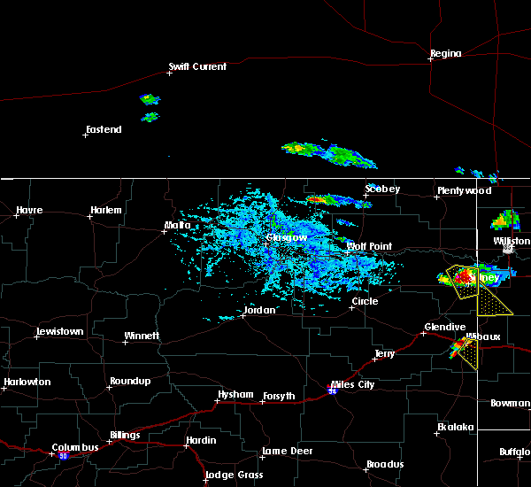 At 445 pm mdt, a severe thunderstorm was located 10 miles south of wibaux, and moving southeast at 20 mph (trained weather spotters). Hazards include 60 mph wind gusts and quarter size hail. Hail damage to crops and plants is expected. some damage to vehicles is possible. expect wind damage to roofs, siding and trees. The severe thunderstorm will affect mainly rural areas of southeastern wibaux county, including the following locations, saint phillip. At 445 pm mdt, a severe thunderstorm was located 10 miles south of wibaux, and moving southeast at 20 mph (trained weather spotters). Hazards include 60 mph wind gusts and quarter size hail. Hail damage to crops and plants is expected. some damage to vehicles is possible. expect wind damage to roofs, siding and trees. The severe thunderstorm will affect mainly rural areas of southeastern wibaux county, including the following locations, saint phillip.
|
| 6/30/2015 4:32 PM MDT | Quarter sized hail reported 5.6 miles ESE of Wibaux, MT, mainly dime sized hail with some quarter. heavy rain |
| 6/30/2015 4:22 PM MDT | At 420 pm mdt, a severe thunderstorm was located 7 miles west of wibaux, and moving southeast at 15 mph (radar indicated). Hazards include 60 mph wind gusts and quarter size hail. Hail damage to crops and plants is expected. some damage to vehicles is possible. expect wind damage to roofs, siding and trees. the severe thunderstorm will be near, wibaux around 440 pm mdt. Other locations in the warning include yates and saint phillip. |
| 6/30/2015 4:22 PM MDT |
 At 420 pm mdt, a severe thunderstorm was located 7 miles west of wibaux, and moving southeast at 15 mph (radar indicated). Hazards include 60 mph wind gusts and quarter size hail. Hail damage to crops and plants is expected. some damage to vehicles is possible. expect wind damage to roofs, siding and trees. the severe thunderstorm will be near, wibaux around 440 pm mdt. Other locations in the warning include yates and saint phillip. At 420 pm mdt, a severe thunderstorm was located 7 miles west of wibaux, and moving southeast at 15 mph (radar indicated). Hazards include 60 mph wind gusts and quarter size hail. Hail damage to crops and plants is expected. some damage to vehicles is possible. expect wind damage to roofs, siding and trees. the severe thunderstorm will be near, wibaux around 440 pm mdt. Other locations in the warning include yates and saint phillip.
|
| 6/21/2015 4:25 PM MDT |
 The severe thunderstorm warning for east central wibaux county will expire at 430 pm mdt, the storm which prompted the warning has moved out of the warned area. The severe thunderstorm warning for east central wibaux county will expire at 430 pm mdt, the storm which prompted the warning has moved out of the warned area.
|
| 6/21/2015 3:53 PM MDT |
 At 346 pm mdt, a severe thunderstorm was located near wibaux, and moving east at 25 mph. quarter-sized hail was reported in wibaux (radar indicated). Hazards include quarter size hail. Damage to crops and plants is expected. some damage to vehicles is possible. The severe thunderstorm will affect mainly rural areas of east central wibaux county. At 346 pm mdt, a severe thunderstorm was located near wibaux, and moving east at 25 mph. quarter-sized hail was reported in wibaux (radar indicated). Hazards include quarter size hail. Damage to crops and plants is expected. some damage to vehicles is possible. The severe thunderstorm will affect mainly rural areas of east central wibaux county.
|
| 6/21/2015 3:50 PM MDT | Half Dollar sized hail reported 0.7 miles NW of Wibaux, MT, estimated 1 1/4 inch hail. heavy rain. |
| 6/19/2015 5:22 PM MDT |
 At 518 pm mdt, a severe thunderstorm was located 11 miles southwest of wibaux, and moving east at 35 mph (radar indicated). Hazards include ping pong ball size hail and 60 mph wind gusts. People and animals outdoors will be injured. expect hail damage to roofs, siding, windows and vehicles. expect wind damage to roofs, siding and trees. the severe thunderstorm will be near, wibaux around 535 pm mdt. Other locations in the warning include yates. At 518 pm mdt, a severe thunderstorm was located 11 miles southwest of wibaux, and moving east at 35 mph (radar indicated). Hazards include ping pong ball size hail and 60 mph wind gusts. People and animals outdoors will be injured. expect hail damage to roofs, siding, windows and vehicles. expect wind damage to roofs, siding and trees. the severe thunderstorm will be near, wibaux around 535 pm mdt. Other locations in the warning include yates.
|
| 6/19/2015 4:53 PM MDT |
 At 453 pm mdt, a severe thunderstorm was located 11 miles south of glendive, and moving east at 45 mph (radar indicated). Hazards include 60 mph wind gusts and quarter size hail. Hail damage to crops and plants is expected. some damage to vehicles is possible. expect wind damage to roofs, siding and trees. the severe thunderstorm will be near, wibaux around 530 pm mdt. Other locations in the warning include hodges and yates. At 453 pm mdt, a severe thunderstorm was located 11 miles south of glendive, and moving east at 45 mph (radar indicated). Hazards include 60 mph wind gusts and quarter size hail. Hail damage to crops and plants is expected. some damage to vehicles is possible. expect wind damage to roofs, siding and trees. the severe thunderstorm will be near, wibaux around 530 pm mdt. Other locations in the warning include hodges and yates.
|
| 6/2/2015 12:32 AM MDT | At 1230 am mdt, a severe thunderstorm was located near wibaux, and moving north at 15 mph (trained weather spotters). Hazards include 60 mph wind gusts and quarter size hail. Hail damage to crops and plants is expected. some damage to vehicles is possible. expect wind damage to roofs, siding and trees. The severe thunderstorm will affect mainly rural areas of central wibaux county. |
| 6/1/2015 11:59 PM MDT | Also with heavy rain and nickel hai in wibaux county MT, 0.7 miles NW of Wibaux, MT |
| 6/1/2015 11:59 AM MDT | Also with heavy rain and nickel hai in wibaux county MT, 0.7 miles NW of Wibaux, MT |
| 7/24/2014 7:35 PM MDT | Half Dollar sized hail reported 5.6 miles ESE of Wibaux, MT, with very heavy rain. |
| 9/17/2013 9:15 PM MDT | Power flickering on and of in wibaux county MT, 5.6 miles ESE of Wibaux, MT |
| 7/11/2013 4:50 PM MDT | Quarter sized hail reported 26.9 miles S of Wibaux, MT, also reported 0.27 of rain |
| 7/8/2013 6:40 PM MDT | Half Dollar sized hail reported 4.4 miles S of Wibaux, MT, garden is destroyed. |
| 7/8/2013 6:40 PM MDT | Several branches with 3 in diameter fell out of the tree in wibaux county MT, 4.4 miles S of Wibaux, MT |
| 7/8/2013 6:30 PM MDT | Storm damage reported in wibaux county MT, 0.7 miles NW of Wibaux, MT |
| 7/8/2013 6:10 PM MDT | Storm damage reported in wibaux county MT, 0.2 miles SSW of Wibaux, MT |
| 5/25/2013 7:30 AM MDT | Quarter sized hail reported 25 miles SSE of Wibaux, MT, pea to quarter size hail |
| 7/28/2012 10:55 PM MDT | Storm damage reported in wibaux county MT, 6.1 miles SE of Wibaux, MT |
| 7/24/2012 5:30 PM MDT | Quarter sized hail reported 5 miles NNW of Wibaux, MT, mostly peas and dimes with very heavy rain |
| 7/24/2012 5:30 PM MDT | Also reported very heavy rain in wibaux county MT, 6.4 miles NNE of Wibaux, MT |
| 6/26/2012 5:04 PM MDT | Beaver hill dot in wibaux county MT, 7 miles ESE of Wibaux, MT |
| 6/23/2012 11:35 AM MDT | Quarter sized hail reported 0.2 miles SSW of Wibaux, MT, from the wibaux visitor center |
| 6/23/2012 11:25 AM MDT | Quarter sized hail reported 0.7 miles NW of Wibaux, MT, slightly larger than quarter hail but not half dollar |
| 6/23/2012 11:25 AM MDT | Quarter sized hail reported 5.7 miles SW of Wibaux, MT, dime to nickel at the start...then quarter hail after |
| 1/1/0001 12:00 AM | Estimated 60 to 70 mph wind gust with heavy rain and pea sized hai in wibaux county MT, 4.1 miles SW of Wibaux, MT |
| 1/1/0001 12:00 AM | Trees knocked ove in wibaux county MT, 0.2 miles SSW of Wibaux, MT |
| 1/1/0001 12:00 AM | Storm damage reported in wibaux county MT, 0.2 miles SSW of Wibaux, MT |
| 1/1/0001 12:00 AM | Storm damage reported in wibaux county MT, 5.3 miles N of Wibaux, MT |
Hail Maps for Wibaux, MT


Connect with Interactive Hail Maps