

Hail Map for Wood Lake, MN
The Wood Lake, MN area has had 2 reports of on-the-ground hail by trained spotters, and has been under severe weather warnings 8 times during the past 12 months. Doppler radar has detected hail at or near Wood Lake, MN on 57 occasions, including 4 occasions during the past year.
| Name: | Wood Lake, MN |
| Where Located: | 22.5 miles SSE of Montevideo, MN |
| Map: | Google Map for Wood Lake, MN |
| Population: | 439 |
| Housing Units: | 195 |
| More Info: | Search Google for Wood Lake, MN |
2
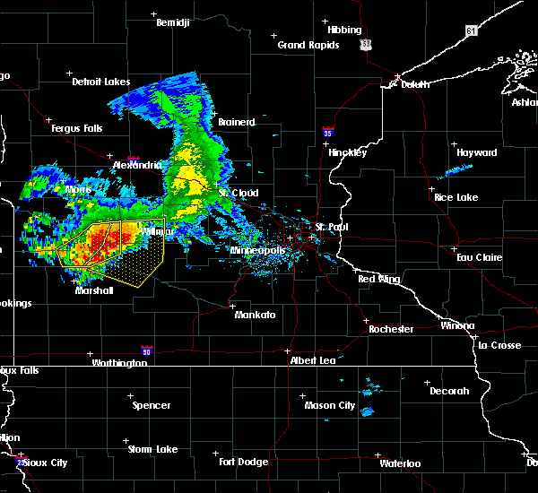
The Top Recent Hail Date for Wood Lake, MN is Saturday, July 13, 2024 (3rd out of 57)

Hail and Wind Damage Spotted near Wood Lake, MN
| Date / Time | Report Details |
|---|---|
| 6/28/2025 10:56 PM CDT |
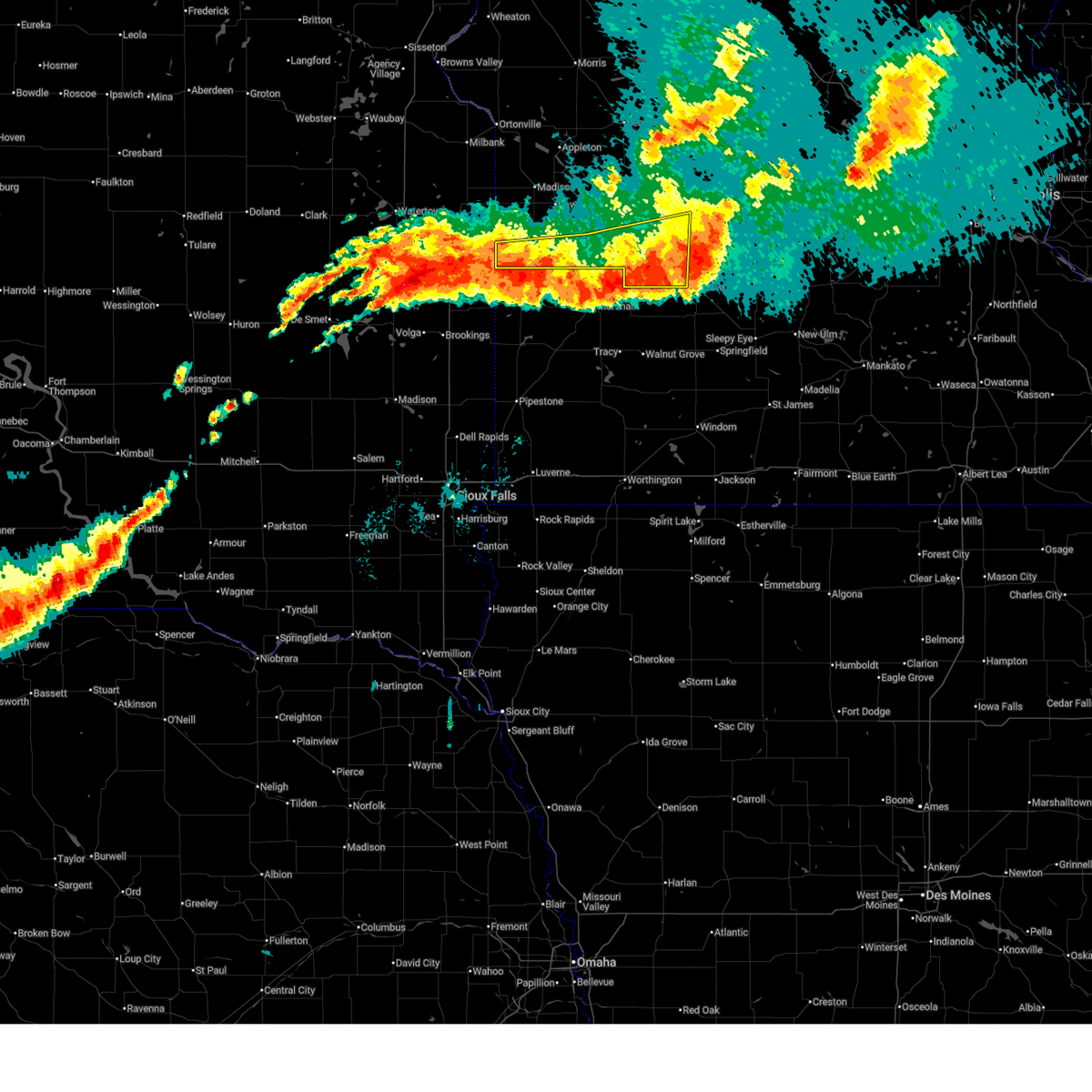 The storms which prompted the warning have moved out of the area. therefore, the warning will be allowed to expire. another severe thunderstorm warning still remains in effect for redwood county, renville county, and yellow medicine county until 1145 pm. The storms which prompted the warning have moved out of the area. therefore, the warning will be allowed to expire. another severe thunderstorm warning still remains in effect for redwood county, renville county, and yellow medicine county until 1145 pm.
|
| 6/28/2025 10:48 PM CDT |
 Svrmpx the national weather service in the twin cities has issued a * severe thunderstorm warning for, renville county in central minnesota, redwood county in southwestern minnesota, southeastern yellow medicine county in west central minnesota, * until 1145 pm cdt. * at 1048 pm cdt, severe thunderstorms were located along a line from 6 miles north of bird island to 12 miles southwest of hanley falls, or along a line from 20 miles south of willmar to 29 miles south of montevideo, moving east at 45 mph (radar indicated). Hazards include 60 mph wind gusts and half dollar size hail. Hail damage to vehicles is expected. Expect wind damage to roofs, siding, and trees. Svrmpx the national weather service in the twin cities has issued a * severe thunderstorm warning for, renville county in central minnesota, redwood county in southwestern minnesota, southeastern yellow medicine county in west central minnesota, * until 1145 pm cdt. * at 1048 pm cdt, severe thunderstorms were located along a line from 6 miles north of bird island to 12 miles southwest of hanley falls, or along a line from 20 miles south of willmar to 29 miles south of montevideo, moving east at 45 mph (radar indicated). Hazards include 60 mph wind gusts and half dollar size hail. Hail damage to vehicles is expected. Expect wind damage to roofs, siding, and trees.
|
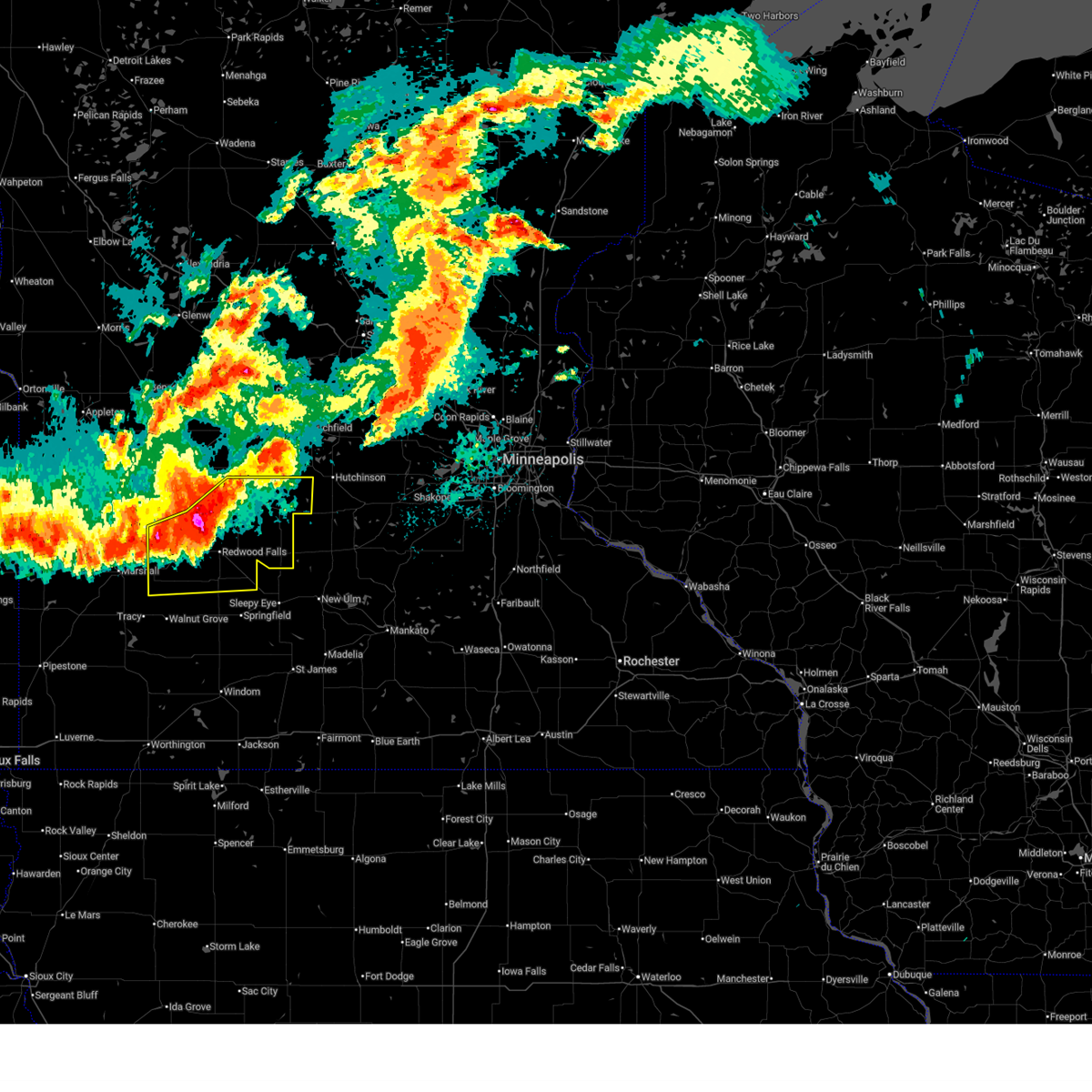
| 6/28/2025 10:35 PM CDT |
 At 1035 pm cdt, severe thunderstorms were located along a line from over renville to 9 miles southwest of canby, or along a line from 16 miles north of redwood falls to 40 miles southwest of montevideo, moving southeast at 25 mph (radar indicated). Hazards include 60 mph wind gusts and quarter size hail. Hail damage to vehicles is expected. expect wind damage to roofs, siding, and trees. locations impacted include, granite falls, canby, renville, clarkfield, sacred heart, wood lake, hanley falls, echo, porter, minnesota falls, belview, spring creek, delhi, hazel run, spellman lake, granite falls airport, upper sioux agency state park, st. Leo and burr. At 1035 pm cdt, severe thunderstorms were located along a line from over renville to 9 miles southwest of canby, or along a line from 16 miles north of redwood falls to 40 miles southwest of montevideo, moving southeast at 25 mph (radar indicated). Hazards include 60 mph wind gusts and quarter size hail. Hail damage to vehicles is expected. expect wind damage to roofs, siding, and trees. locations impacted include, granite falls, canby, renville, clarkfield, sacred heart, wood lake, hanley falls, echo, porter, minnesota falls, belview, spring creek, delhi, hazel run, spellman lake, granite falls airport, upper sioux agency state park, st. Leo and burr.
|
| 6/28/2025 10:21 PM CDT |
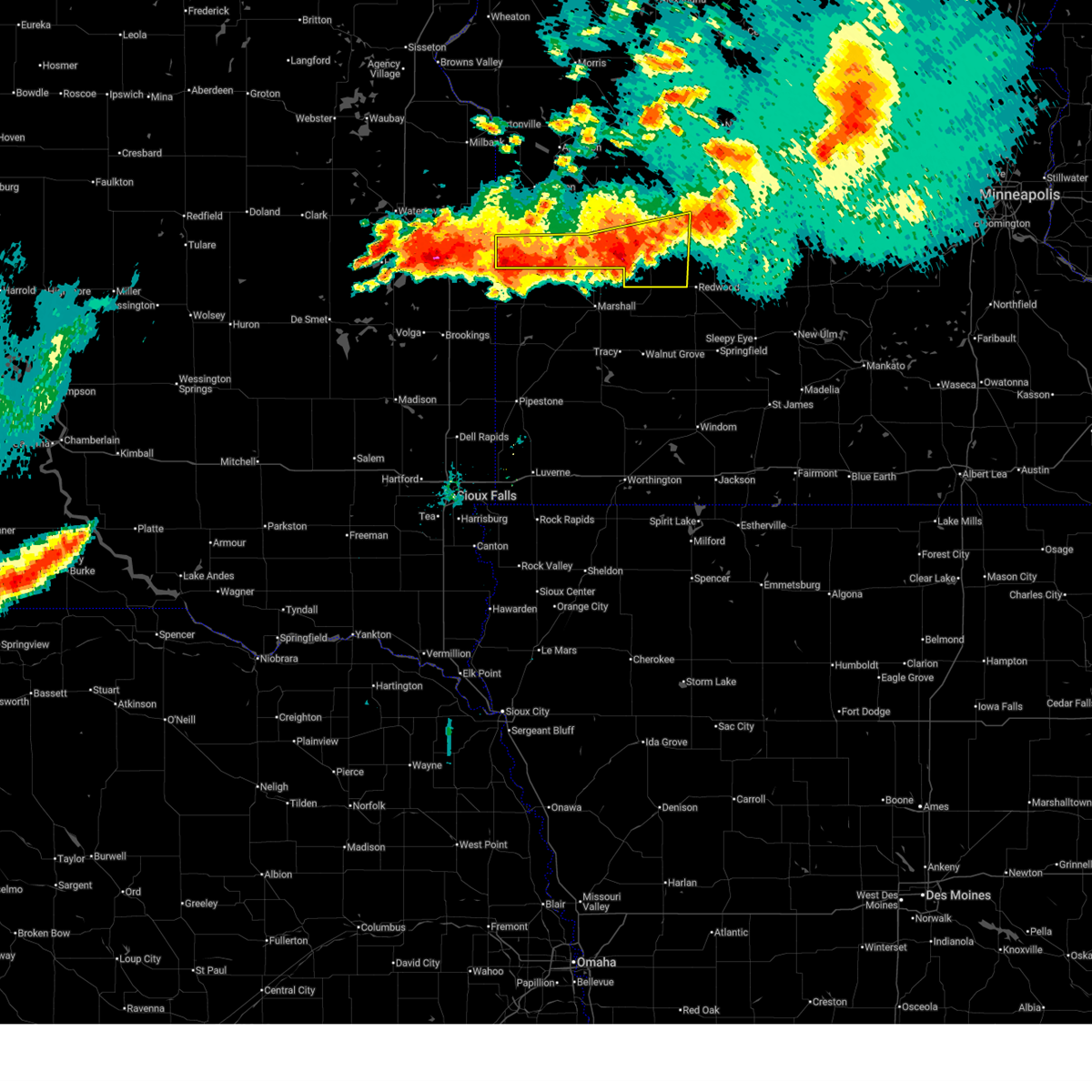 Svrmpx the national weather service in the twin cities has issued a * severe thunderstorm warning for, northwestern renville county in central minnesota, northwestern redwood county in southwestern minnesota, south central chippewa county in west central minnesota, yellow medicine county in west central minnesota, * until 1100 pm cdt. * at 1021 pm cdt, severe thunderstorms were located along a line from near renville to 9 miles southwest of canby, or along a line from 18 miles northwest of redwood falls to 40 miles southwest of montevideo, moving east at 30 mph (radar indicated). Hazards include 60 mph wind gusts and quarter size hail. Hail damage to vehicles is expected. Expect wind damage to roofs, siding, and trees. Svrmpx the national weather service in the twin cities has issued a * severe thunderstorm warning for, northwestern renville county in central minnesota, northwestern redwood county in southwestern minnesota, south central chippewa county in west central minnesota, yellow medicine county in west central minnesota, * until 1100 pm cdt. * at 1021 pm cdt, severe thunderstorms were located along a line from near renville to 9 miles southwest of canby, or along a line from 18 miles northwest of redwood falls to 40 miles southwest of montevideo, moving east at 30 mph (radar indicated). Hazards include 60 mph wind gusts and quarter size hail. Hail damage to vehicles is expected. Expect wind damage to roofs, siding, and trees.
|
| 7/15/2024 4:18 AM CDT |
 Svrmpx the national weather service in the twin cities has issued a * severe thunderstorm warning for, south central chippewa county in west central minnesota, north central redwood county in southwestern minnesota, eastern yellow medicine county in west central minnesota, northwestern renville county in central minnesota, * until 500 am cdt. * at 417 am cdt, a severe thunderstorm was located over granite falls, or 11 miles southeast of montevideo, moving southeast at 45 mph (radar indicated). Hazards include ping pong ball size hail and 60 mph wind gusts. People and animals outdoors will be injured. expect hail damage to roofs, siding, windows, and vehicles. Expect wind damage to roofs, siding, and trees. Svrmpx the national weather service in the twin cities has issued a * severe thunderstorm warning for, south central chippewa county in west central minnesota, north central redwood county in southwestern minnesota, eastern yellow medicine county in west central minnesota, northwestern renville county in central minnesota, * until 500 am cdt. * at 417 am cdt, a severe thunderstorm was located over granite falls, or 11 miles southeast of montevideo, moving southeast at 45 mph (radar indicated). Hazards include ping pong ball size hail and 60 mph wind gusts. People and animals outdoors will be injured. expect hail damage to roofs, siding, windows, and vehicles. Expect wind damage to roofs, siding, and trees.
|
| 7/13/2024 8:00 AM CDT | Quarter sized hail reported 0.2 miles NE of Wood Lake, MN |
| 7/13/2024 8:00 AM CDT | Hen Egg sized hail reported 1.4 miles NE of Wood Lake, MN, caller noted a lot of corn damage associated with hail. |
| 7/13/2024 7:57 AM CDT |
 At 757 am cdt, a severe thunderstorm was located over wood lake, or 19 miles northeast of marshall, moving southeast at 20 mph (radar indicated). Hazards include ping pong ball size hail and 60 mph wind gusts. People and animals outdoors will be injured. expect hail damage to roofs, siding, windows, and vehicles. expect wind damage to roofs, siding, and trees. Locations impacted include, echo. At 757 am cdt, a severe thunderstorm was located over wood lake, or 19 miles northeast of marshall, moving southeast at 20 mph (radar indicated). Hazards include ping pong ball size hail and 60 mph wind gusts. People and animals outdoors will be injured. expect hail damage to roofs, siding, windows, and vehicles. expect wind damage to roofs, siding, and trees. Locations impacted include, echo.
|
| 7/13/2024 7:57 AM CDT |
 the severe thunderstorm warning has been cancelled and is no longer in effect the severe thunderstorm warning has been cancelled and is no longer in effect
|
| 7/13/2024 7:25 AM CDT |
 Svrmpx the national weather service in the twin cities has issued a * severe thunderstorm warning for, northwestern redwood county in southwestern minnesota, eastern yellow medicine county in west central minnesota, west central renville county in central minnesota, * until 815 am cdt. * at 725 am cdt, a severe thunderstorm was located near hanley falls, or 16 miles south of montevideo, moving southeast at 20 mph (radar indicated). Hazards include ping pong ball size hail and 60 mph wind gusts. People and animals outdoors will be injured. expect hail damage to roofs, siding, windows, and vehicles. expect wind damage to roofs, siding, and trees. this severe thunderstorm will be near, hanley falls around 730 am cdt. wood lake around 735 am cdt. Other locations in the path of this severe thunderstorm include echo. Svrmpx the national weather service in the twin cities has issued a * severe thunderstorm warning for, northwestern redwood county in southwestern minnesota, eastern yellow medicine county in west central minnesota, west central renville county in central minnesota, * until 815 am cdt. * at 725 am cdt, a severe thunderstorm was located near hanley falls, or 16 miles south of montevideo, moving southeast at 20 mph (radar indicated). Hazards include ping pong ball size hail and 60 mph wind gusts. People and animals outdoors will be injured. expect hail damage to roofs, siding, windows, and vehicles. expect wind damage to roofs, siding, and trees. this severe thunderstorm will be near, hanley falls around 730 am cdt. wood lake around 735 am cdt. Other locations in the path of this severe thunderstorm include echo.
|
| 6/17/2024 9:44 PM CDT |
 Svrmpx the national weather service in the twin cities has issued a * severe thunderstorm warning for, northwestern redwood county in southwestern minnesota, southeastern yellow medicine county in west central minnesota, northwestern renville county in central minnesota, * until 1030 pm cdt. * at 944 pm cdt, a severe thunderstorm was located over echo, or 17 miles west of redwood falls, moving northeast at 40 mph (radar indicated). Hazards include quarter size hail. damage to vehicles is expected Svrmpx the national weather service in the twin cities has issued a * severe thunderstorm warning for, northwestern redwood county in southwestern minnesota, southeastern yellow medicine county in west central minnesota, northwestern renville county in central minnesota, * until 1030 pm cdt. * at 944 pm cdt, a severe thunderstorm was located over echo, or 17 miles west of redwood falls, moving northeast at 40 mph (radar indicated). Hazards include quarter size hail. damage to vehicles is expected
|
| 9/29/2023 5:33 PM CDT |
 At 533 pm cdt, a severe thunderstorm was located over marshall, moving northeast at 40 mph (radar indicated). Hazards include half dollar size hail. damage to vehicles is expected At 533 pm cdt, a severe thunderstorm was located over marshall, moving northeast at 40 mph (radar indicated). Hazards include half dollar size hail. damage to vehicles is expected
|
| 8/2/2022 10:46 PM CDT |
 At 1046 pm cdt, severe thunderstorms were located along a line extending from near clara city to 6 miles southeast of renville to near lamberton, moving east at 70 mph (radar indicated). Hazards include 70 mph wind gusts. Expect considerable tree damage. damage is likely to mobile homes, roofs, and outbuildings. locations impacted include, redwood falls, granite falls, olivia, renville, morgan, lamberton, wabasso, sacred heart, franklin, wood lake, morton and echo. thunderstorm damage threat, considerable hail threat, radar indicated max hail size, <. 75 in wind threat, radar indicated max wind gust, 70 mph. At 1046 pm cdt, severe thunderstorms were located along a line extending from near clara city to 6 miles southeast of renville to near lamberton, moving east at 70 mph (radar indicated). Hazards include 70 mph wind gusts. Expect considerable tree damage. damage is likely to mobile homes, roofs, and outbuildings. locations impacted include, redwood falls, granite falls, olivia, renville, morgan, lamberton, wabasso, sacred heart, franklin, wood lake, morton and echo. thunderstorm damage threat, considerable hail threat, radar indicated max hail size, <. 75 in wind threat, radar indicated max wind gust, 70 mph.
|
| 8/2/2022 10:29 PM CDT |
 At 1029 pm cdt, severe thunderstorms were located along a line extending from 5 miles southeast of montevideo to wood lake to 8 miles north of walnut grove, moving east at 60 mph (radar indicated). Hazards include 70 mph wind gusts. Expect considerable tree damage. damage is likely to mobile homes, roofs, and outbuildings. locations impacted include, echo, wabasso, sacred heart, maynard, clara city, renville, redwood falls, olivia, morgan, morton and franklin. thunderstorm damage threat, considerable hail threat, radar indicated max hail size, <. 75 in wind threat, radar indicated max wind gust, 70 mph. At 1029 pm cdt, severe thunderstorms were located along a line extending from 5 miles southeast of montevideo to wood lake to 8 miles north of walnut grove, moving east at 60 mph (radar indicated). Hazards include 70 mph wind gusts. Expect considerable tree damage. damage is likely to mobile homes, roofs, and outbuildings. locations impacted include, echo, wabasso, sacred heart, maynard, clara city, renville, redwood falls, olivia, morgan, morton and franklin. thunderstorm damage threat, considerable hail threat, radar indicated max hail size, <. 75 in wind threat, radar indicated max wind gust, 70 mph.
|
| 8/2/2022 10:13 PM CDT |
 At 1012 pm cdt, severe thunderstorms were located along a line extending from near boyd to 6 miles northeast of ghent to 7 miles northwest of tracy, moving east at 60 mph (radar indicated). Hazards include 70 mph wind gusts. a 74 mph gust was reported at marshall airport. Expect considerable tree damage. damage is likely to mobile homes, roofs, and outbuildings. severe thunderstorms will be near, clarkfield around 1020 pm cdt. montevideo, wood lake and hanley falls around 1025 pm cdt. granite falls and echo around 1030 pm cdt. wabasso, sacred heart and maynard around 1035 pm cdt. clara city around 1040 pm cdt. redwood falls and renville around 1045 pm cdt. thunderstorm damage threat, considerable hail threat, radar indicated max hail size, <. 75 in wind threat, observed max wind gust, 70 mph. At 1012 pm cdt, severe thunderstorms were located along a line extending from near boyd to 6 miles northeast of ghent to 7 miles northwest of tracy, moving east at 60 mph (radar indicated). Hazards include 70 mph wind gusts. a 74 mph gust was reported at marshall airport. Expect considerable tree damage. damage is likely to mobile homes, roofs, and outbuildings. severe thunderstorms will be near, clarkfield around 1020 pm cdt. montevideo, wood lake and hanley falls around 1025 pm cdt. granite falls and echo around 1030 pm cdt. wabasso, sacred heart and maynard around 1035 pm cdt. clara city around 1040 pm cdt. redwood falls and renville around 1045 pm cdt. thunderstorm damage threat, considerable hail threat, radar indicated max hail size, <. 75 in wind threat, observed max wind gust, 70 mph.
|
| 7/23/2022 10:01 AM CDT |
 At 1001 am cdt, severe thunderstorms were located along a line extending from near kerkhoven to near clara city to near wood lake, moving east at 45 mph (radar indicated). Hazards include 60 mph wind gusts and quarter size hail. Hail damage to vehicles is expected. expect wind damage to roofs, siding, and trees. severe thunderstorms will be near, raymond and sacred heart around 1010 am cdt. prinsburg around 1015 am cdt. willmar around 1020 am cdt. other locations in the path of these severe thunderstorms include olivia, atwater and bird island. hail threat, radar indicated max hail size, 1. 00 in wind threat, radar indicated max wind gust, 60 mph. At 1001 am cdt, severe thunderstorms were located along a line extending from near kerkhoven to near clara city to near wood lake, moving east at 45 mph (radar indicated). Hazards include 60 mph wind gusts and quarter size hail. Hail damage to vehicles is expected. expect wind damage to roofs, siding, and trees. severe thunderstorms will be near, raymond and sacred heart around 1010 am cdt. prinsburg around 1015 am cdt. willmar around 1020 am cdt. other locations in the path of these severe thunderstorms include olivia, atwater and bird island. hail threat, radar indicated max hail size, 1. 00 in wind threat, radar indicated max wind gust, 60 mph.
|
| 6/21/2022 12:08 AM CDT |
 At 1208 am cdt, severe thunderstorms were located along a line extending from 8 miles southwest of kerkhoven to near granite falls to near cottonwood, moving east at 40 mph (radar indicated). Hazards include 60 mph wind gusts. Expect damage to roofs, siding, and trees. locations impacted include, willmar, granite falls, clara city, raymond, sacred heart, prinsburg, wood lake, maynard, hanley falls, echo, pennock and minnesota falls. hail threat, radar indicated max hail size, <. 75 in wind threat, radar indicated max wind gust, 60 mph. At 1208 am cdt, severe thunderstorms were located along a line extending from 8 miles southwest of kerkhoven to near granite falls to near cottonwood, moving east at 40 mph (radar indicated). Hazards include 60 mph wind gusts. Expect damage to roofs, siding, and trees. locations impacted include, willmar, granite falls, clara city, raymond, sacred heart, prinsburg, wood lake, maynard, hanley falls, echo, pennock and minnesota falls. hail threat, radar indicated max hail size, <. 75 in wind threat, radar indicated max wind gust, 60 mph.
|
| 6/20/2022 11:49 PM CDT |
 At 1148 pm cdt, severe thunderstorms were located along a line extending from 8 miles northeast of watson to 5 miles northeast of taunton, moving east at 30 mph (radar indicated). Hazards include 60 mph wind gusts. expect damage to roofs, siding, and trees At 1148 pm cdt, severe thunderstorms were located along a line extending from 8 miles northeast of watson to 5 miles northeast of taunton, moving east at 30 mph (radar indicated). Hazards include 60 mph wind gusts. expect damage to roofs, siding, and trees
|
| 6/20/2022 9:37 PM CDT |
 At 936 pm cdt, a severe thunderstorm was located over wood lake, or 20 miles southeast of montevideo, moving east at 45 mph (radar indicated). Hazards include 60 mph wind gusts. Expect damage to roofs, siding, and trees. this severe thunderstorm will remain over mainly rural areas of eastern yellow medicine county, including the following locations, granite falls airport, spellman lake and hazel run. hail threat, radar indicated max hail size, <. 75 in wind threat, observed max wind gust, 60 mph. At 936 pm cdt, a severe thunderstorm was located over wood lake, or 20 miles southeast of montevideo, moving east at 45 mph (radar indicated). Hazards include 60 mph wind gusts. Expect damage to roofs, siding, and trees. this severe thunderstorm will remain over mainly rural areas of eastern yellow medicine county, including the following locations, granite falls airport, spellman lake and hazel run. hail threat, radar indicated max hail size, <. 75 in wind threat, observed max wind gust, 60 mph.
|
| 6/20/2022 9:19 PM CDT |
 At 918 pm cdt, severe thunderstorms were located along a line extending from 5 miles southwest of clarkfield to 6 miles southwest of cottonwood, moving northeast at 50 mph (radar indicated. at 902 pm, a 68 mph gust was measured at taunton). Hazards include 60 mph wind gusts. Expect damage to roofs, siding, and trees. these severe storms will be near, hanley falls around 930 pm cdt. wood lake around 935 pm cdt. granite falls around 940 pm cdt. other locations impacted by these severe thunderstorms include granite falls airport, spring creek, spellman lake and hazel run. hail threat, radar indicated max hail size, <. 75 in wind threat, observed max wind gust, 60 mph. At 918 pm cdt, severe thunderstorms were located along a line extending from 5 miles southwest of clarkfield to 6 miles southwest of cottonwood, moving northeast at 50 mph (radar indicated. at 902 pm, a 68 mph gust was measured at taunton). Hazards include 60 mph wind gusts. Expect damage to roofs, siding, and trees. these severe storms will be near, hanley falls around 930 pm cdt. wood lake around 935 pm cdt. granite falls around 940 pm cdt. other locations impacted by these severe thunderstorms include granite falls airport, spring creek, spellman lake and hazel run. hail threat, radar indicated max hail size, <. 75 in wind threat, observed max wind gust, 60 mph.
|
| 6/20/2022 9:02 PM CDT |
 At 902 pm cdt, severe thunderstorms were located along a line extending from near taunton to near minneota to arco, moving northeast at 45 mph (radar indicated). Hazards include 60 mph wind gusts. Expect damage to roofs, siding, and trees. severe thunderstorms will be near, clarkfield around 925 pm cdt. hanley falls around 935 pm cdt. granite falls around 945 pm cdt. wood lake around 950 pm cdt. other locations impacted by these severe thunderstorms include granite falls airport, spring creek, spellman lake, hazel run and st. leo. hail threat, radar indicated max hail size, <. 75 in wind threat, radar indicated max wind gust, 60 mph. At 902 pm cdt, severe thunderstorms were located along a line extending from near taunton to near minneota to arco, moving northeast at 45 mph (radar indicated). Hazards include 60 mph wind gusts. Expect damage to roofs, siding, and trees. severe thunderstorms will be near, clarkfield around 925 pm cdt. hanley falls around 935 pm cdt. granite falls around 945 pm cdt. wood lake around 950 pm cdt. other locations impacted by these severe thunderstorms include granite falls airport, spring creek, spellman lake, hazel run and st. leo. hail threat, radar indicated max hail size, <. 75 in wind threat, radar indicated max wind gust, 60 mph.
|
| 5/30/2022 7:12 PM CDT |
 At 711 pm cdt, severe thunderstorms were located along a line extending from 5 miles northeast of gary to 9 miles northeast of taunton to marshall, moving northeast at 75 mph (radar indicated). Hazards include 60 mph wind gusts. Expect damage to roofs, siding, and trees. these severe storms will be near, clarkfield and boyd around 720 pm cdt. madison, wood lake, hanley falls and echo around 725 pm cdt. granite falls around 730 pm cdt. other locations impacted by these severe thunderstorms include granite falls airport, nassau, providence, big stone national wildlife refuge, burr, st. leo, madison airport, hazel run, louisburg and spring creek. hail threat, radar indicated max hail size, <. 75 in wind threat, radar indicated max wind gust, 60 mph. At 711 pm cdt, severe thunderstorms were located along a line extending from 5 miles northeast of gary to 9 miles northeast of taunton to marshall, moving northeast at 75 mph (radar indicated). Hazards include 60 mph wind gusts. Expect damage to roofs, siding, and trees. these severe storms will be near, clarkfield and boyd around 720 pm cdt. madison, wood lake, hanley falls and echo around 725 pm cdt. granite falls around 730 pm cdt. other locations impacted by these severe thunderstorms include granite falls airport, nassau, providence, big stone national wildlife refuge, burr, st. leo, madison airport, hazel run, louisburg and spring creek. hail threat, radar indicated max hail size, <. 75 in wind threat, radar indicated max wind gust, 60 mph.
|
| 5/30/2022 6:56 PM CDT |
 At 655 pm cdt, severe thunderstorms were located along a line extending from near brandt to ivanhoe to near balaton, moving northeast at 75 mph (radar indicated). Hazards include 60 mph wind gusts. Expect damage to roofs, siding, and trees. severe thunderstorms will be near, porter around 705 pm cdt. clarkfield and boyd around 720 pm cdt. madison, wood lake and echo around 725 pm cdt. other locations impacted by these severe thunderstorms include granite falls airport, nassau, providence, big stone national wildlife refuge, burr, st. leo, madison airport, hazel run, louisburg and spring creek. hail threat, radar indicated max hail size, <. 75 in wind threat, radar indicated max wind gust, 60 mph. At 655 pm cdt, severe thunderstorms were located along a line extending from near brandt to ivanhoe to near balaton, moving northeast at 75 mph (radar indicated). Hazards include 60 mph wind gusts. Expect damage to roofs, siding, and trees. severe thunderstorms will be near, porter around 705 pm cdt. clarkfield and boyd around 720 pm cdt. madison, wood lake and echo around 725 pm cdt. other locations impacted by these severe thunderstorms include granite falls airport, nassau, providence, big stone national wildlife refuge, burr, st. leo, madison airport, hazel run, louisburg and spring creek. hail threat, radar indicated max hail size, <. 75 in wind threat, radar indicated max wind gust, 60 mph.
|
| 5/30/2022 4:47 PM CDT |
 At 447 pm cdt, severe thunderstorms were located along a line extending from 5 miles southeast of granite falls to echo to 9 miles west of wabasso, moving northeast at 70 mph (radar indicated). Hazards include 70 mph wind gusts and nickel size hail. Expect considerable tree damage. damage is likely to mobile homes, roofs, and outbuildings. Locations impacted include, renville, walnut grove, wabasso, sacred heart, wood lake, echo, minnesota falls, belview, vesta, milroy, lucan and revere. At 447 pm cdt, severe thunderstorms were located along a line extending from 5 miles southeast of granite falls to echo to 9 miles west of wabasso, moving northeast at 70 mph (radar indicated). Hazards include 70 mph wind gusts and nickel size hail. Expect considerable tree damage. damage is likely to mobile homes, roofs, and outbuildings. Locations impacted include, renville, walnut grove, wabasso, sacred heart, wood lake, echo, minnesota falls, belview, vesta, milroy, lucan and revere.
|
| 5/30/2022 4:30 PM CDT |
 At 430 pm cdt, severe thunderstorms were located along a line extending from 7 miles south of cottonwood to 11 miles east of marshall to near tracy, moving northeast at 70 mph (radar indicated). Hazards include 70 mph wind gusts and nickel size hail. Expect considerable tree damage. damage is likely to mobile homes, roofs, and outbuildings. Locations impacted include, wood lake, echo, sacred heart and renville. At 430 pm cdt, severe thunderstorms were located along a line extending from 7 miles south of cottonwood to 11 miles east of marshall to near tracy, moving northeast at 70 mph (radar indicated). Hazards include 70 mph wind gusts and nickel size hail. Expect considerable tree damage. damage is likely to mobile homes, roofs, and outbuildings. Locations impacted include, wood lake, echo, sacred heart and renville.
|
| 5/30/2022 4:18 PM CDT |
 At 417 pm cdt, severe thunderstorms were located along a line extending from 6 miles south of marshall to near tracy to near slayton, moving northeast at 70 mph (radar indicated). Hazards include 70 mph wind gusts and nickel size hail. Expect considerable tree damage. damage is likely to mobile homes, roofs, and outbuildings. severe thunderstorms will be near, walnut grove and wood lake around 435 pm cdt. Other locations in the path of these severe thunderstorms include echo, sacred heart and renville. At 417 pm cdt, severe thunderstorms were located along a line extending from 6 miles south of marshall to near tracy to near slayton, moving northeast at 70 mph (radar indicated). Hazards include 70 mph wind gusts and nickel size hail. Expect considerable tree damage. damage is likely to mobile homes, roofs, and outbuildings. severe thunderstorms will be near, walnut grove and wood lake around 435 pm cdt. Other locations in the path of these severe thunderstorms include echo, sacred heart and renville.
|
| 5/30/2022 4:12 PM CDT |
 At 412 pm cdt, severe thunderstorms were located along a line extending from near boyd to 6 miles northwest of cottonwood to marshall, moving northeast at 65 mph (radar indicated). Hazards include 70 mph wind gusts and penny size hail. Expect considerable tree damage. damage is likely to mobile homes, roofs, and outbuildings. these severe storms will be near, boyd around 415 pm cdt. montevideo and clarkfield around 420 pm cdt. Other locations in the path of these severe thunderstorms include watson, wood lake, hanley falls, granite falls and maynard. At 412 pm cdt, severe thunderstorms were located along a line extending from near boyd to 6 miles northwest of cottonwood to marshall, moving northeast at 65 mph (radar indicated). Hazards include 70 mph wind gusts and penny size hail. Expect considerable tree damage. damage is likely to mobile homes, roofs, and outbuildings. these severe storms will be near, boyd around 415 pm cdt. montevideo and clarkfield around 420 pm cdt. Other locations in the path of these severe thunderstorms include watson, wood lake, hanley falls, granite falls and maynard.
|
| 5/30/2022 4:00 PM CDT |
 At 359 pm cdt, severe thunderstorms were located along a line extending from 9 miles southwest of boyd to ghent to near camden state park, moving northeast at 70 mph (radar indicated). Hazards include 70 mph wind gusts and half dollar size hail. Hail damage to vehicles is expected. expect considerable tree damage. wind damage is also likely to mobile homes, roofs, and outbuildings. severe thunderstorms will be near, clarkfield around 405 pm cdt. boyd around 410 pm cdt. montevideo around 415 pm cdt. Other locations in the path of these severe thunderstorms include watson, wood lake, maynard, hanley falls and granite falls. At 359 pm cdt, severe thunderstorms were located along a line extending from 9 miles southwest of boyd to ghent to near camden state park, moving northeast at 70 mph (radar indicated). Hazards include 70 mph wind gusts and half dollar size hail. Hail damage to vehicles is expected. expect considerable tree damage. wind damage is also likely to mobile homes, roofs, and outbuildings. severe thunderstorms will be near, clarkfield around 405 pm cdt. boyd around 410 pm cdt. montevideo around 415 pm cdt. Other locations in the path of these severe thunderstorms include watson, wood lake, maynard, hanley falls and granite falls.
|
| 5/12/2022 9:23 PM CDT |
 The severe thunderstorm warning for northern redwood and yellow medicine counties will expire at 930 pm cdt, the storm which prompted the warning has weakened below severe limits, and no longer poses an immediate threat to life or property. therefore, the warning will be allowed to expire. however gusty winds and heavy rain are still possible with this thunderstorm. a tornado watch remains in effect until midnight cdt for central, southwestern and west central minnesota. The severe thunderstorm warning for northern redwood and yellow medicine counties will expire at 930 pm cdt, the storm which prompted the warning has weakened below severe limits, and no longer poses an immediate threat to life or property. therefore, the warning will be allowed to expire. however gusty winds and heavy rain are still possible with this thunderstorm. a tornado watch remains in effect until midnight cdt for central, southwestern and west central minnesota.
|
| 5/12/2022 8:54 PM CDT |
 At 853 pm cdt, a severe thunderstorm was located near ghent, or near marshall, moving northeast at 60 mph (radar indicated). Hazards include 60 mph wind gusts and quarter size hail. Hail damage to vehicles is expected. Expect wind damage to roofs, siding, and trees. At 853 pm cdt, a severe thunderstorm was located near ghent, or near marshall, moving northeast at 60 mph (radar indicated). Hazards include 60 mph wind gusts and quarter size hail. Hail damage to vehicles is expected. Expect wind damage to roofs, siding, and trees.
|
| 5/12/2022 6:34 PM CDT |
 At 633 pm cdt, severe thunderstorms were located along a line extending from near bellingham to 5 miles southwest of watson to cottonwood, moving northeast at 45 mph (radar indicated). Hazards include 70 mph wind gusts continuing behind the line of storms. Expect considerable tree damage. Damage is likely to mobile homes, roofs, and outbuildings. At 633 pm cdt, severe thunderstorms were located along a line extending from near bellingham to 5 miles southwest of watson to cottonwood, moving northeast at 45 mph (radar indicated). Hazards include 70 mph wind gusts continuing behind the line of storms. Expect considerable tree damage. Damage is likely to mobile homes, roofs, and outbuildings.
|
| 5/12/2022 6:20 PM CDT |
 At 620 pm cdt, severe thunderstorms were located along a line extending from near echo to near storden to near spirit lake, moving northeast at 70 mph (radar indicated). Hazards include 70 mph wind gusts. Expect considerable tree damage. damage is likely to mobile homes, roofs, and outbuildings. these severe storms will be near, echo around 625 pm cdt. sacred heart around 630 pm cdt. renville and comfrey around 635 pm cdt. springfield around 640 pm cdt. sherburn around 645 pm cdt. sleepy eye and trimont around 650 pm cdt. truman around 700 pm cdt. lewisville around 705 pm cdt. thunderstorm damage threat, considerable hail threat, radar indicated max hail size, <. 75 in wind threat, radar indicated max wind gust, 70 mph. At 620 pm cdt, severe thunderstorms were located along a line extending from near echo to near storden to near spirit lake, moving northeast at 70 mph (radar indicated). Hazards include 70 mph wind gusts. Expect considerable tree damage. damage is likely to mobile homes, roofs, and outbuildings. these severe storms will be near, echo around 625 pm cdt. sacred heart around 630 pm cdt. renville and comfrey around 635 pm cdt. springfield around 640 pm cdt. sherburn around 645 pm cdt. sleepy eye and trimont around 650 pm cdt. truman around 700 pm cdt. lewisville around 705 pm cdt. thunderstorm damage threat, considerable hail threat, radar indicated max hail size, <. 75 in wind threat, radar indicated max wind gust, 70 mph.
|
| 5/12/2022 6:12 PM CDT |
 At 612 pm cdt, severe thunderstorms were located along a line extending from near twin brooks to 6 miles northeast of madison to 5 miles south of wood lake, moving northeast at 95 mph. these are destructive storms for madison, montevideo, and granite falls (radar indicated). Hazards include 100 mph wind gusts and quarter size hail. a 94 mph gust was measured in madison!. You are in a life-threatening situation. flying debris may be deadly to those caught without shelter. mobile homes will be destroyed. expect considerable damage to homes and businesses. expect extensive tree damage and power outages. these severe storms will be near, appleton around 620 pm cdt. lake oliver around 625 pm cdt. other locations impacted by these severe thunderstorms include granite falls airport, nassau, asbury, providence, big stone national wildlife refuge, montevideo airport, burr, st. leo, hagen and big bend city. thunderstorm damage threat, destructive hail threat, radar indicated max hail size, 1. 00 in wind threat, observed max wind gust, 100 mph. At 612 pm cdt, severe thunderstorms were located along a line extending from near twin brooks to 6 miles northeast of madison to 5 miles south of wood lake, moving northeast at 95 mph. these are destructive storms for madison, montevideo, and granite falls (radar indicated). Hazards include 100 mph wind gusts and quarter size hail. a 94 mph gust was measured in madison!. You are in a life-threatening situation. flying debris may be deadly to those caught without shelter. mobile homes will be destroyed. expect considerable damage to homes and businesses. expect extensive tree damage and power outages. these severe storms will be near, appleton around 620 pm cdt. lake oliver around 625 pm cdt. other locations impacted by these severe thunderstorms include granite falls airport, nassau, asbury, providence, big stone national wildlife refuge, montevideo airport, burr, st. leo, hagen and big bend city. thunderstorm damage threat, destructive hail threat, radar indicated max hail size, 1. 00 in wind threat, observed max wind gust, 100 mph.
|
| 5/12/2022 6:02 PM CDT |
 At 602 pm cdt, severe thunderstorms were located along a line extending from near camden state park to 5 miles south of fulda to 6 miles southeast of ocheyedan, moving northeast at 75 mph (radar indicated). Hazards include 70 mph wind gusts and quarter size hail. Hail damage to vehicles is expected. expect considerable tree damage. wind damage is also likely to mobile homes, roofs, and outbuildings. severe thunderstorms will be near, wood lake and echo around 625 pm cdt. springfield, sherburn, sacred heart and comfrey around 635 pm cdt. renville and trimont around 640 pm cdt. sleepy eye and olivia around 645 pm cdt. new ulm, truman and lewisville around 655 pm cdt. madelia around 700 pm cdt. thunderstorm damage threat, considerable hail threat, radar indicated max hail size, 1. 00 in wind threat, radar indicated max wind gust, 70 mph. At 602 pm cdt, severe thunderstorms were located along a line extending from near camden state park to 5 miles south of fulda to 6 miles southeast of ocheyedan, moving northeast at 75 mph (radar indicated). Hazards include 70 mph wind gusts and quarter size hail. Hail damage to vehicles is expected. expect considerable tree damage. wind damage is also likely to mobile homes, roofs, and outbuildings. severe thunderstorms will be near, wood lake and echo around 625 pm cdt. springfield, sherburn, sacred heart and comfrey around 635 pm cdt. renville and trimont around 640 pm cdt. sleepy eye and olivia around 645 pm cdt. new ulm, truman and lewisville around 655 pm cdt. madelia around 700 pm cdt. thunderstorm damage threat, considerable hail threat, radar indicated max hail size, 1. 00 in wind threat, radar indicated max wind gust, 70 mph.
|
| 5/12/2022 5:54 PM CDT |
 At 553 pm cdt, severe thunderstorms were located along a line extending from 6 miles southeast of pelican lake to lake cochrane rec area to near ruthton, moving northeast at 85 mph. these are destructive storms for canby and madison (trained weather spotters). Hazards include 90 mph wind gusts and quarter size hail. You are in a life-threatening situation. flying debris may be deadly to those caught without shelter. mobile homes will be heavily damaged or destroyed. homes and businesses will have substantial roof and window damage. expect extensive tree damage and power outages. these severe storms will be near, marietta around 605 pm cdt. madison around 610 pm cdt. bellingham around 615 pm cdt. appleton around 620 pm cdt. clarkfield, hanley falls and lake oliver around 625 pm cdt. granite falls around 630 pm cdt. other locations impacted by these severe thunderstorms include granite falls airport, nassau, asbury, providence, big stone national wildlife refuge, montevideo airport, burr, st. leo, hagen and big bend city. thunderstorm damage threat, destructive hail threat, radar indicated max hail size, 1. 00 in wind threat, observed max wind gust, 90 mph. At 553 pm cdt, severe thunderstorms were located along a line extending from 6 miles southeast of pelican lake to lake cochrane rec area to near ruthton, moving northeast at 85 mph. these are destructive storms for canby and madison (trained weather spotters). Hazards include 90 mph wind gusts and quarter size hail. You are in a life-threatening situation. flying debris may be deadly to those caught without shelter. mobile homes will be heavily damaged or destroyed. homes and businesses will have substantial roof and window damage. expect extensive tree damage and power outages. these severe storms will be near, marietta around 605 pm cdt. madison around 610 pm cdt. bellingham around 615 pm cdt. appleton around 620 pm cdt. clarkfield, hanley falls and lake oliver around 625 pm cdt. granite falls around 630 pm cdt. other locations impacted by these severe thunderstorms include granite falls airport, nassau, asbury, providence, big stone national wildlife refuge, montevideo airport, burr, st. leo, hagen and big bend city. thunderstorm damage threat, destructive hail threat, radar indicated max hail size, 1. 00 in wind threat, observed max wind gust, 90 mph.
|
| 5/12/2022 5:41 PM CDT |
 At 540 pm cdt, severe thunderstorms were located along a line extending from near hayti to near toronto to near pipestone, moving north at 90 mph. these are destructive storms for canby and madison (trained weather spotters). Hazards include 90 mph wind gusts and quarter size hail. You are in a life-threatening situation. flying debris may be deadly to those caught without shelter. mobile homes will be heavily damaged or destroyed. homes and businesses will have substantial roof and window damage. expect extensive tree damage and power outages. severe thunderstorms will be near, marietta around 605 pm cdt. porter and bellingham around 610 pm cdt. boyd around 620 pm cdt. dawson around 625 pm cdt. milan and watson around 630 pm cdt. other locations impacted by these severe thunderstorms include granite falls airport, nassau, asbury, providence, big stone national wildlife refuge, montevideo airport, burr, st. leo, hagen and big bend city. thunderstorm damage threat, destructive hail threat, radar indicated max hail size, 1. 00 in wind threat, observed max wind gust, 90 mph. At 540 pm cdt, severe thunderstorms were located along a line extending from near hayti to near toronto to near pipestone, moving north at 90 mph. these are destructive storms for canby and madison (trained weather spotters). Hazards include 90 mph wind gusts and quarter size hail. You are in a life-threatening situation. flying debris may be deadly to those caught without shelter. mobile homes will be heavily damaged or destroyed. homes and businesses will have substantial roof and window damage. expect extensive tree damage and power outages. severe thunderstorms will be near, marietta around 605 pm cdt. porter and bellingham around 610 pm cdt. boyd around 620 pm cdt. dawson around 625 pm cdt. milan and watson around 630 pm cdt. other locations impacted by these severe thunderstorms include granite falls airport, nassau, asbury, providence, big stone national wildlife refuge, montevideo airport, burr, st. leo, hagen and big bend city. thunderstorm damage threat, destructive hail threat, radar indicated max hail size, 1. 00 in wind threat, observed max wind gust, 90 mph.
|
| 5/11/2022 5:46 PM CDT |
 At 545 pm cdt, a severe thunderstorm was located over hanley falls, or 18 miles southeast of montevideo, moving northwest at 30 mph (radar indicated). Hazards include 60 mph wind gusts and quarter size hail. Hail damage to vehicles is expected. expect wind damage to roofs, siding, and trees. locations impacted include, granite falls. hail threat, radar indicated max hail size, 1. 00 in wind threat, radar indicated max wind gust, 60 mph. At 545 pm cdt, a severe thunderstorm was located over hanley falls, or 18 miles southeast of montevideo, moving northwest at 30 mph (radar indicated). Hazards include 60 mph wind gusts and quarter size hail. Hail damage to vehicles is expected. expect wind damage to roofs, siding, and trees. locations impacted include, granite falls. hail threat, radar indicated max hail size, 1. 00 in wind threat, radar indicated max wind gust, 60 mph.
|
| 5/11/2022 5:23 PM CDT |
 At 523 pm cdt, a severe thunderstorm was located over hanley falls, or 17 miles northeast of marshall, moving northwest at 30 mph (radar indicated). Hazards include 60 mph wind gusts and quarter size hail. Hail damage to vehicles is expected. expect wind damage to roofs, siding, and trees. this severe thunderstorm will be near, granite falls around 540 pm cdt. Other locations in the path of this severe thunderstorm include clarkfield and boyd. At 523 pm cdt, a severe thunderstorm was located over hanley falls, or 17 miles northeast of marshall, moving northwest at 30 mph (radar indicated). Hazards include 60 mph wind gusts and quarter size hail. Hail damage to vehicles is expected. expect wind damage to roofs, siding, and trees. this severe thunderstorm will be near, granite falls around 540 pm cdt. Other locations in the path of this severe thunderstorm include clarkfield and boyd.
|
| 5/11/2022 12:37 PM CDT |
 At 1237 pm cdt, a severe thunderstorm was located over cottonwood, or 14 miles northeast of marshall, moving northeast at 25 mph (radar indicated). Hazards include half dollar size hail. Damage to vehicles is expected. this severe thunderstorm will be near, wood lake around 1245 pm cdt. hanley falls around 1250 pm cdt. other locations in the path of this severe thunderstorm include granite falls and maynard. hail threat, radar indicated max hail size, 1. 25 in wind threat, radar indicated max wind gust, <50 mph. At 1237 pm cdt, a severe thunderstorm was located over cottonwood, or 14 miles northeast of marshall, moving northeast at 25 mph (radar indicated). Hazards include half dollar size hail. Damage to vehicles is expected. this severe thunderstorm will be near, wood lake around 1245 pm cdt. hanley falls around 1250 pm cdt. other locations in the path of this severe thunderstorm include granite falls and maynard. hail threat, radar indicated max hail size, 1. 25 in wind threat, radar indicated max wind gust, <50 mph.
|
| 10/11/2020 8:33 PM CDT |
 At 833 pm cdt, a severe thunderstorm was located near echo, or 17 miles northwest of redwood falls, moving northeast at 45 mph (radar indicated). Hazards include 60 mph wind gusts. Expect damage to roofs, siding, and trees. this severe storm will be near, sacred heart around 845 pm cdt. renville around 850 pm cdt. Other locations impacted by this severe thunderstorm include bechyn, belview, danube and minnesota falls. At 833 pm cdt, a severe thunderstorm was located near echo, or 17 miles northwest of redwood falls, moving northeast at 45 mph (radar indicated). Hazards include 60 mph wind gusts. Expect damage to roofs, siding, and trees. this severe storm will be near, sacred heart around 845 pm cdt. renville around 850 pm cdt. Other locations impacted by this severe thunderstorm include bechyn, belview, danube and minnesota falls.
|
| 10/11/2020 8:25 PM CDT |
 At 825 pm cdt, a severe thunderstorm was located over wood lake, or 18 miles northeast of marshall, moving northeast at 45 mph (radar indicated). Hazards include 60 mph wind gusts. Expect damage to roofs, siding, and trees. this severe thunderstorm will be near, echo around 830 pm cdt. sacred heart around 845 pm cdt. renville around 850 pm cdt. other locations impacted by this severe thunderstorm include granite falls airport, bechyn, belview, danube, minnesota falls and delhi. This includes prairies edge casino resort. At 825 pm cdt, a severe thunderstorm was located over wood lake, or 18 miles northeast of marshall, moving northeast at 45 mph (radar indicated). Hazards include 60 mph wind gusts. Expect damage to roofs, siding, and trees. this severe thunderstorm will be near, echo around 830 pm cdt. sacred heart around 845 pm cdt. renville around 850 pm cdt. other locations impacted by this severe thunderstorm include granite falls airport, bechyn, belview, danube, minnesota falls and delhi. This includes prairies edge casino resort.
|
| 9/6/2020 12:39 AM CDT |
 At 1239 am cdt, a severe thunderstorm was located near granite falls, or 17 miles southeast of montevideo, moving southeast at 35 mph (radar indicated). Hazards include 60 mph wind gusts and quarter size hail. Hail damage to vehicles is expected. expect wind damage to roofs, siding, and trees. this severe storm will be near, sacred heart around 1250 am cdt. echo around 1255 am cdt. Other locations impacted by this severe thunderstorm include granite falls airport and minnesota falls. At 1239 am cdt, a severe thunderstorm was located near granite falls, or 17 miles southeast of montevideo, moving southeast at 35 mph (radar indicated). Hazards include 60 mph wind gusts and quarter size hail. Hail damage to vehicles is expected. expect wind damage to roofs, siding, and trees. this severe storm will be near, sacred heart around 1250 am cdt. echo around 1255 am cdt. Other locations impacted by this severe thunderstorm include granite falls airport and minnesota falls.
|
| 9/6/2020 12:09 AM CDT |
 The national weather service in the twin cities has issued a * severe thunderstorm warning for. southeastern chippewa county in west central minnesota. northeastern yellow medicine county in west central minnesota. northwestern renville county in central minnesota. Until 115 am cdt. The national weather service in the twin cities has issued a * severe thunderstorm warning for. southeastern chippewa county in west central minnesota. northeastern yellow medicine county in west central minnesota. northwestern renville county in central minnesota. Until 115 am cdt.
|
| 8/28/2020 3:23 AM CDT |
 At 322 am cdt, severe thunderstorms were located along a line extending from 7 miles north of watson to near granite falls to near echo to 7 miles north of walnut grove, moving east at 65 mph (radar indicated). Hazards include 60 mph wind gusts. Expect damage to roofs, siding, and trees. these severe storms will be near, wabasso around 330 am cdt. redwood falls, renville and prinsburg around 335 am cdt. morton and murdock around 340 am cdt. kerkhoven around 345 am cdt. morgan and franklin around 350 am cdt. willmar and hector around 355 am cdt. fairfax around 400 am cdt. Other locations impacted by these severe thunderstorms include bechyn, seaforth, asbury, delhi, clements, willmar airport, revere, blomkest, lake lillian and belview. At 322 am cdt, severe thunderstorms were located along a line extending from 7 miles north of watson to near granite falls to near echo to 7 miles north of walnut grove, moving east at 65 mph (radar indicated). Hazards include 60 mph wind gusts. Expect damage to roofs, siding, and trees. these severe storms will be near, wabasso around 330 am cdt. redwood falls, renville and prinsburg around 335 am cdt. morton and murdock around 340 am cdt. kerkhoven around 345 am cdt. morgan and franklin around 350 am cdt. willmar and hector around 355 am cdt. fairfax around 400 am cdt. Other locations impacted by these severe thunderstorms include bechyn, seaforth, asbury, delhi, clements, willmar airport, revere, blomkest, lake lillian and belview.
|
| 8/28/2020 2:58 AM CDT |
 At 258 am cdt, severe thunderstorms were located along a line extending from near madison to near clarkfield to ghent to near balaton, moving east at 65 mph (radar indicated). Hazards include 60 mph wind gusts. Expect damage to roofs, siding, and trees. severe thunderstorms will be near, clarkfield around 305 am cdt. dawson and hanley falls around 310 am cdt. granite falls, wood lake and milan around 315 am cdt. walnut grove, maynard, echo and watson around 320 am cdt. sacred heart around 325 am cdt. redwood falls, renville and wabasso around 330 am cdt. prinsburg around 335 am cdt. olivia, morton and murdock around 340 am cdt. other locations impacted by these severe thunderstorms include bechyn, seaforth, asbury, delhi, clements, willmar airport, revere, blomkest, lake lillian and belview. This includes prairies edge casino resort and jackpot junction casino. At 258 am cdt, severe thunderstorms were located along a line extending from near madison to near clarkfield to ghent to near balaton, moving east at 65 mph (radar indicated). Hazards include 60 mph wind gusts. Expect damage to roofs, siding, and trees. severe thunderstorms will be near, clarkfield around 305 am cdt. dawson and hanley falls around 310 am cdt. granite falls, wood lake and milan around 315 am cdt. walnut grove, maynard, echo and watson around 320 am cdt. sacred heart around 325 am cdt. redwood falls, renville and wabasso around 330 am cdt. prinsburg around 335 am cdt. olivia, morton and murdock around 340 am cdt. other locations impacted by these severe thunderstorms include bechyn, seaforth, asbury, delhi, clements, willmar airport, revere, blomkest, lake lillian and belview. This includes prairies edge casino resort and jackpot junction casino.
|
| 8/8/2020 1:14 PM CDT |
 At 113 pm cdt, a severe thunderstorm was located near marshall, moving southeast at 50 mph. wind gusts up to 70 mph have been reported previously with this storm (radar indicated). Hazards include 70 mph wind gusts. Expect considerable tree damage. Damage is likely to mobile homes, roofs, and outbuildings. At 113 pm cdt, a severe thunderstorm was located near marshall, moving southeast at 50 mph. wind gusts up to 70 mph have been reported previously with this storm (radar indicated). Hazards include 70 mph wind gusts. Expect considerable tree damage. Damage is likely to mobile homes, roofs, and outbuildings.
|
| 7/18/2020 1:21 AM CDT |
 At 120 am cdt, severe thunderstorms were located along a line extending from near canby to near granite falls to spicer, moving southeast at 45 mph (radar indicated). Hazards include 60 mph wind gusts. Expect damage to roofs, siding, and trees. these severe storms will be near, granite falls, new london, spicer and maynard around 125 am cdt. atwater around 135 am cdt. sacred heart around 140 am cdt. Renville around 145 am cdt. At 120 am cdt, severe thunderstorms were located along a line extending from near canby to near granite falls to spicer, moving southeast at 45 mph (radar indicated). Hazards include 60 mph wind gusts. Expect damage to roofs, siding, and trees. these severe storms will be near, granite falls, new london, spicer and maynard around 125 am cdt. atwater around 135 am cdt. sacred heart around 140 am cdt. Renville around 145 am cdt.
|
| 7/18/2020 12:44 AM CDT |
 At 1244 am cdt, severe thunderstorms were located along a line extending from near revillo to 7 miles west of milan to 8 miles northeast of kerkhoven, moving southeast at 55 mph (radar indicated). Hazards include 70 mph wind gusts. Expect considerable tree damage. damage is likely to mobile homes, roofs, and outbuildings. severe thunderstorms will be near, willmar, new london and spicer around 1255 am cdt. watson around 100 am cdt. montevideo around 105 am cdt. canby and atwater around 110 am cdt. granite falls, maynard and porter around 120 am cdt. sacred heart around 130 am cdt. renville around 135 am cdt. other locations impacted by these severe thunderstorms include nassau, asbury, willmar airport, blomkest, st. leo, lake lillian, green lake, madison airport, hazel run and cerro gordo. This also includes prairies edge casino resort. At 1244 am cdt, severe thunderstorms were located along a line extending from near revillo to 7 miles west of milan to 8 miles northeast of kerkhoven, moving southeast at 55 mph (radar indicated). Hazards include 70 mph wind gusts. Expect considerable tree damage. damage is likely to mobile homes, roofs, and outbuildings. severe thunderstorms will be near, willmar, new london and spicer around 1255 am cdt. watson around 100 am cdt. montevideo around 105 am cdt. canby and atwater around 110 am cdt. granite falls, maynard and porter around 120 am cdt. sacred heart around 130 am cdt. renville around 135 am cdt. other locations impacted by these severe thunderstorms include nassau, asbury, willmar airport, blomkest, st. leo, lake lillian, green lake, madison airport, hazel run and cerro gordo. This also includes prairies edge casino resort.
|
| 7/1/2019 2:42 AM CDT |
 At 242 am cdt, a severe thunderstorm was located over wood lake, or 17 miles northeast of marshall, moving east at 55 mph (radar indicated). Hazards include 60 mph wind gusts and penny size hail. expect damage to roofs, siding, and trees At 242 am cdt, a severe thunderstorm was located over wood lake, or 17 miles northeast of marshall, moving east at 55 mph (radar indicated). Hazards include 60 mph wind gusts and penny size hail. expect damage to roofs, siding, and trees
|
| 6/30/2019 8:18 PM CDT |
 At 818 pm cdt, severe thunderstorms were located along a line extending from hanley falls to 7 miles east of echo to near redwood falls, moving east at 25 mph (radar indicated). Hazards include 60 mph wind gusts and quarter size hail. Hail damage to vehicles is expected. expect wind damage to roofs, siding, and trees. Locations impacted include, redwood falls, wood lake, morton, hanley falls, echo, belview, delhi, granite falls airport, north redwood and redwood falls airport. At 818 pm cdt, severe thunderstorms were located along a line extending from hanley falls to 7 miles east of echo to near redwood falls, moving east at 25 mph (radar indicated). Hazards include 60 mph wind gusts and quarter size hail. Hail damage to vehicles is expected. expect wind damage to roofs, siding, and trees. Locations impacted include, redwood falls, wood lake, morton, hanley falls, echo, belview, delhi, granite falls airport, north redwood and redwood falls airport.
|
| 6/30/2019 7:58 PM CDT |
 At 757 pm cdt, a severe thunderstorm was located over wood lake, or 19 miles northeast of marshall, moving east at 20 mph (radar indicated). Hazards include ping pong ball size hail and 60 mph wind gusts. People and animals outdoors will be injured. expect hail damage to roofs, siding, windows, and vehicles. Expect wind damage to roofs, siding, and trees. At 757 pm cdt, a severe thunderstorm was located over wood lake, or 19 miles northeast of marshall, moving east at 20 mph (radar indicated). Hazards include ping pong ball size hail and 60 mph wind gusts. People and animals outdoors will be injured. expect hail damage to roofs, siding, windows, and vehicles. Expect wind damage to roofs, siding, and trees.
|
| 6/20/2019 3:54 PM CDT |
 At 354 pm cdt, a severe thunderstorm was located near hanley falls, or 13 miles south of montevideo, moving east at 20 mph (radar indicated). Hazards include 60 mph wind gusts and half dollar size hail. Hail damage to vehicles is expected. expect wind damage to roofs, siding, and trees. this severe storm will be near, granite falls around 410 pm cdt. Other locations impacted by this severe thunderstorm include granite falls airport and hazel run. At 354 pm cdt, a severe thunderstorm was located near hanley falls, or 13 miles south of montevideo, moving east at 20 mph (radar indicated). Hazards include 60 mph wind gusts and half dollar size hail. Hail damage to vehicles is expected. expect wind damage to roofs, siding, and trees. this severe storm will be near, granite falls around 410 pm cdt. Other locations impacted by this severe thunderstorm include granite falls airport and hazel run.
|
| 6/20/2019 3:40 PM CDT |
 At 339 pm cdt, a severe thunderstorm was located near clarkfield, or 13 miles south of montevideo, moving east at 20 mph (radar indicated). Hazards include 60 mph wind gusts and half dollar size hail. Hail damage to vehicles is expected. expect wind damage to roofs, siding, and trees. this severe thunderstorm will be near, hanley falls around 355 pm cdt. granite falls around 410 pm cdt. other locations impacted by this severe thunderstorm include granite falls airport, spellman lake and hazel run. this includes the following highways, u. s. highway 212 between mile markers 42 and 52. u. s. highway 59 between mile markers 89 and 100. This includes prairies edge casino resort. At 339 pm cdt, a severe thunderstorm was located near clarkfield, or 13 miles south of montevideo, moving east at 20 mph (radar indicated). Hazards include 60 mph wind gusts and half dollar size hail. Hail damage to vehicles is expected. expect wind damage to roofs, siding, and trees. this severe thunderstorm will be near, hanley falls around 355 pm cdt. granite falls around 410 pm cdt. other locations impacted by this severe thunderstorm include granite falls airport, spellman lake and hazel run. this includes the following highways, u. s. highway 212 between mile markers 42 and 52. u. s. highway 59 between mile markers 89 and 100. This includes prairies edge casino resort.
|
| 6/4/2019 6:06 PM CDT |
 The severe thunderstorm warning for southeastern yellow medicine county will expire at 615 pm cdt, the storm which prompted the warning has weakened below severe limits, and no longer poses an immediate threat to life or property. therefore, the warning will be allowed to expire. a severe thunderstorm watch remains in effect until 800 pm cdt for central, southwestern and west central minnesota. The severe thunderstorm warning for southeastern yellow medicine county will expire at 615 pm cdt, the storm which prompted the warning has weakened below severe limits, and no longer poses an immediate threat to life or property. therefore, the warning will be allowed to expire. a severe thunderstorm watch remains in effect until 800 pm cdt for central, southwestern and west central minnesota.
|
| 6/4/2019 5:30 PM CDT |
 At 529 pm cdt, a severe thunderstorm was located over hanley falls, or 17 miles northeast of marshall, moving southeast at 10 mph (radar indicated). Hazards include 60 mph wind gusts and half dollar size hail. Hail damage to vehicles is expected. Expect wind damage to roofs, siding, and trees. At 529 pm cdt, a severe thunderstorm was located over hanley falls, or 17 miles northeast of marshall, moving southeast at 10 mph (radar indicated). Hazards include 60 mph wind gusts and half dollar size hail. Hail damage to vehicles is expected. Expect wind damage to roofs, siding, and trees.
|
| 6/4/2019 4:53 PM CDT |
 At 453 pm cdt, a severe thunderstorm was located over echo, or 16 miles northwest of redwood falls, moving southeast at 25 mph (radar indicated). Hazards include 60 mph wind gusts and quarter size hail. Hail damage to vehicles is expected. Expect wind damage to roofs, siding, and trees. At 453 pm cdt, a severe thunderstorm was located over echo, or 16 miles northwest of redwood falls, moving southeast at 25 mph (radar indicated). Hazards include 60 mph wind gusts and quarter size hail. Hail damage to vehicles is expected. Expect wind damage to roofs, siding, and trees.
|
| 6/4/2019 4:33 PM CDT |
 At 432 pm cdt, a severe thunderstorm was located near wood lake, or 18 miles southeast of montevideo, moving southeast at 25 mph (trained weather spotters). Hazards include 60 mph wind gusts and quarter size hail. Hail damage to vehicles is expected. expect wind damage to roofs, siding, and trees. this severe thunderstorm will be near, echo around 450 pm cdt. other locations impacted by this severe thunderstorm include granite falls airport and belview. This includes prairies edge casino resort. At 432 pm cdt, a severe thunderstorm was located near wood lake, or 18 miles southeast of montevideo, moving southeast at 25 mph (trained weather spotters). Hazards include 60 mph wind gusts and quarter size hail. Hail damage to vehicles is expected. expect wind damage to roofs, siding, and trees. this severe thunderstorm will be near, echo around 450 pm cdt. other locations impacted by this severe thunderstorm include granite falls airport and belview. This includes prairies edge casino resort.
|
| 6/4/2019 2:07 PM CDT |
 At 207 pm cdt, a severe thunderstorm was located over maynard, or 9 miles east of montevideo, moving southeast at 25 mph (radar indicated). Hazards include 60 mph wind gusts and quarter size hail. Hail damage to vehicles is expected. expect wind damage to roofs, siding, and trees. Locations impacted include, granite falls, clara city, clarkfield, wood lake, maynard, hanley falls, minnesota falls, hazel run, granite falls airport, asbury and gluek. At 207 pm cdt, a severe thunderstorm was located over maynard, or 9 miles east of montevideo, moving southeast at 25 mph (radar indicated). Hazards include 60 mph wind gusts and quarter size hail. Hail damage to vehicles is expected. expect wind damage to roofs, siding, and trees. Locations impacted include, granite falls, clara city, clarkfield, wood lake, maynard, hanley falls, minnesota falls, hazel run, granite falls airport, asbury and gluek.
|
| 6/4/2019 1:47 PM CDT |
 At 147 pm cdt, a severe thunderstorm was located near montevideo, moving southeast at 25 mph (radar indicated). Hazards include golf ball size hail and 60 mph wind gusts. People and animals outdoors will be injured. expect hail damage to roofs, siding, windows, and vehicles. Expect wind damage to roofs, siding, and trees. At 147 pm cdt, a severe thunderstorm was located near montevideo, moving southeast at 25 mph (radar indicated). Hazards include golf ball size hail and 60 mph wind gusts. People and animals outdoors will be injured. expect hail damage to roofs, siding, windows, and vehicles. Expect wind damage to roofs, siding, and trees.
|
| 7/3/2018 12:48 AM CDT |
 At 1247 am cdt, severe thunderstorms were located along a line extending from 6 miles southeast of cottonwood to near tracy, moving northeast at 25 mph (radar indicated). Hazards include half dollar size hail. damage to vehicles is expected At 1247 am cdt, severe thunderstorms were located along a line extending from 6 miles southeast of cottonwood to near tracy, moving northeast at 25 mph (radar indicated). Hazards include half dollar size hail. damage to vehicles is expected
|
| 5/29/2018 1:57 PM CDT |
 At 157 pm cdt, a severe thunderstorm was located over echo, or 17 miles northwest of redwood falls, moving north at 15 mph (radar indicated). Hazards include 60 mph wind gusts and quarter size hail. Hail damage to vehicles is expected. expect wind damage to roofs, siding, and trees. this severe storm will be near, sacred heart around 215 pm cdt. Other locations impacted by this severe thunderstorm include granite falls airport, seaforth, vesta and belview. At 157 pm cdt, a severe thunderstorm was located over echo, or 17 miles northwest of redwood falls, moving north at 15 mph (radar indicated). Hazards include 60 mph wind gusts and quarter size hail. Hail damage to vehicles is expected. expect wind damage to roofs, siding, and trees. this severe storm will be near, sacred heart around 215 pm cdt. Other locations impacted by this severe thunderstorm include granite falls airport, seaforth, vesta and belview.
|
| 5/29/2018 1:36 PM CDT |
 At 135 pm cdt, a severe thunderstorm was located near echo, or 17 miles west of redwood falls, moving north at 30 mph (radar indicated). Hazards include 60 mph wind gusts and quarter size hail. Hail damage to vehicles is expected. expect wind damage to roofs, siding, and trees. this severe storm will be near, echo around 140 pm cdt. wood lake around 145 pm cdt. sacred heart around 205 pm cdt. Other locations impacted by this severe thunderstorm include granite falls airport, seaforth, vesta and belview. At 135 pm cdt, a severe thunderstorm was located near echo, or 17 miles west of redwood falls, moving north at 30 mph (radar indicated). Hazards include 60 mph wind gusts and quarter size hail. Hail damage to vehicles is expected. expect wind damage to roofs, siding, and trees. this severe storm will be near, echo around 140 pm cdt. wood lake around 145 pm cdt. sacred heart around 205 pm cdt. Other locations impacted by this severe thunderstorm include granite falls airport, seaforth, vesta and belview.
|
| 5/29/2018 1:26 PM CDT |
 At 126 pm cdt, a severe thunderstorm was located over vesta, or 16 miles east of marshall, moving north at 25 mph (radar indicated). Hazards include 60 mph wind gusts and quarter size hail. Hail damage to vehicles is expected. expect wind damage to roofs, siding, and trees. this severe thunderstorm will be near, wood lake and echo around 145 pm cdt. sacred heart around 210 pm cdt. other locations impacted by this severe thunderstorm include granite falls airport, seaforth, vesta and belview. this includes u. s. highway 212 between mile markers 53 and 65. This includes prairies edge casino resort. At 126 pm cdt, a severe thunderstorm was located over vesta, or 16 miles east of marshall, moving north at 25 mph (radar indicated). Hazards include 60 mph wind gusts and quarter size hail. Hail damage to vehicles is expected. expect wind damage to roofs, siding, and trees. this severe thunderstorm will be near, wood lake and echo around 145 pm cdt. sacred heart around 210 pm cdt. other locations impacted by this severe thunderstorm include granite falls airport, seaforth, vesta and belview. this includes u. s. highway 212 between mile markers 53 and 65. This includes prairies edge casino resort.
|
| 6/11/2017 6:43 AM CDT |
 At 643 am cdt, severe thunderstorms were located along a line extending from near granite falls to near marshall, moving east at 55 mph (trained weather spotters). Hazards include 70 mph wind gusts and quarter size hail. Hail damage to vehicles is expected. expect considerable tree damage. wind damage is also likely to mobile homes, roofs, and outbuildings. these severe storms will be near, sacred heart around 700 am cdt. Other locations impacted by these severe thunderstorms include granite falls airport, seaforth, delhi, belview, milroy, vesta, spellman lake and minnesota falls. At 643 am cdt, severe thunderstorms were located along a line extending from near granite falls to near marshall, moving east at 55 mph (trained weather spotters). Hazards include 70 mph wind gusts and quarter size hail. Hail damage to vehicles is expected. expect considerable tree damage. wind damage is also likely to mobile homes, roofs, and outbuildings. these severe storms will be near, sacred heart around 700 am cdt. Other locations impacted by these severe thunderstorms include granite falls airport, seaforth, delhi, belview, milroy, vesta, spellman lake and minnesota falls.
|
| 6/11/2017 6:27 AM CDT |
 At 627 am cdt, severe thunderstorms were located along a line extending from boyd to near camden state park, moving east at 50 mph (radar indicated). Hazards include 70 mph wind gusts and quarter size hail. Hail damage to vehicles is expected. expect considerable tree damage. wind damage is also likely to mobile homes, roofs, and outbuildings. severe thunderstorms will be near, sacred heart around 700 am cdt. other locations impacted by these severe thunderstorms include granite falls airport, seaforth, delhi, belview, milroy, vesta, spellman lake and minnesota falls. this includes the following highways, u. s. highway 212 between mile markers 53 and 64. u. s. Highway 59 between mile markers 87 and 92. At 627 am cdt, severe thunderstorms were located along a line extending from boyd to near camden state park, moving east at 50 mph (radar indicated). Hazards include 70 mph wind gusts and quarter size hail. Hail damage to vehicles is expected. expect considerable tree damage. wind damage is also likely to mobile homes, roofs, and outbuildings. severe thunderstorms will be near, sacred heart around 700 am cdt. other locations impacted by these severe thunderstorms include granite falls airport, seaforth, delhi, belview, milroy, vesta, spellman lake and minnesota falls. this includes the following highways, u. s. highway 212 between mile markers 53 and 64. u. s. Highway 59 between mile markers 87 and 92.
|
| 8/4/2016 6:10 AM CDT |
 At 609 am cdt, severe thunderstorms were located along a line extending from near granite falls airport to vesta to near revere, moving east at 50 mph (radar indicated). Hazards include 60 mph wind gusts and quarter size hail. Hail damage to vehicles is expected. expect wind damage to roofs, siding, and trees. severe thunderstorms will be near, wabasso and sacred heart around 620 am cdt. redwood falls and renville around 625 am cdt. olivia, morgan and morton around 635 am cdt. bird island and franklin around 640 am cdt. fairfax around 650 am cdt. Hector around 655 am cdt. At 609 am cdt, severe thunderstorms were located along a line extending from near granite falls airport to vesta to near revere, moving east at 50 mph (radar indicated). Hazards include 60 mph wind gusts and quarter size hail. Hail damage to vehicles is expected. expect wind damage to roofs, siding, and trees. severe thunderstorms will be near, wabasso and sacred heart around 620 am cdt. redwood falls and renville around 625 am cdt. olivia, morgan and morton around 635 am cdt. bird island and franklin around 640 am cdt. fairfax around 650 am cdt. Hector around 655 am cdt.
|
| 7/16/2016 8:09 PM CDT |
 At 809 pm cdt, severe thunderstorms were located along a line extending from near clara city to near maynard to granite falls airport, moving east at 35 mph. these are very dangerous storms (radar indicated). Hazards include 80 mph wind gusts and ping pong ball size hail. Flying debris will be dangerous to those caught without shelter. mobile homes will be heavily damaged. expect considerable damage to roofs, windows, and vehicles. extensive tree damage and power outages are likely. these severe storms will be near, clara city around 815 pm cdt. sacred heart around 820 pm cdt. Other locations impacted by these severe thunderstorms include minnesota falls, hazel run, spellman lake, spring creek, granite falls airport, gluek and asbury. At 809 pm cdt, severe thunderstorms were located along a line extending from near clara city to near maynard to granite falls airport, moving east at 35 mph. these are very dangerous storms (radar indicated). Hazards include 80 mph wind gusts and ping pong ball size hail. Flying debris will be dangerous to those caught without shelter. mobile homes will be heavily damaged. expect considerable damage to roofs, windows, and vehicles. extensive tree damage and power outages are likely. these severe storms will be near, clara city around 815 pm cdt. sacred heart around 820 pm cdt. Other locations impacted by these severe thunderstorms include minnesota falls, hazel run, spellman lake, spring creek, granite falls airport, gluek and asbury.
|
| 7/16/2016 8:04 PM CDT |
 At 803 pm cdt, severe thunderstorms were located along a line extending from 6 miles northwest of raymond to near maynard to hanley falls, moving east at 30 mph. these are very dangerous storms (radar indicated). Hazards include 80 mph wind gusts and ping pong ball size hail. Flying debris will be dangerous to those caught without shelter. mobile homes will be heavily damaged. expect considerable damage to roofs, windows, and vehicles. extensive tree damage and power outages are likely. severe thunderstorms will be near, clara city around 810 pm cdt. sacred heart around 815 pm cdt. raymond around 820 pm cdt. prinsburg around 825 pm cdt. renville and echo around 830 pm cdt. olivia around 850 pm cdt. redwood falls and bird island around 855 pm cdt. Other locations impacted by these severe thunderstorms include minnesota falls, kandiyohi, danube, svea, delhi, willmar airport, lake lillian, priam, north redwood and bechyn. At 803 pm cdt, severe thunderstorms were located along a line extending from 6 miles northwest of raymond to near maynard to hanley falls, moving east at 30 mph. these are very dangerous storms (radar indicated). Hazards include 80 mph wind gusts and ping pong ball size hail. Flying debris will be dangerous to those caught without shelter. mobile homes will be heavily damaged. expect considerable damage to roofs, windows, and vehicles. extensive tree damage and power outages are likely. severe thunderstorms will be near, clara city around 810 pm cdt. sacred heart around 815 pm cdt. raymond around 820 pm cdt. prinsburg around 825 pm cdt. renville and echo around 830 pm cdt. olivia around 850 pm cdt. redwood falls and bird island around 855 pm cdt. Other locations impacted by these severe thunderstorms include minnesota falls, kandiyohi, danube, svea, delhi, willmar airport, lake lillian, priam, north redwood and bechyn.
|
| 7/16/2016 7:53 PM CDT |
 At 752 pm cdt, severe thunderstorms were located along a line extending from near gluek to near montevideo to clarkfield, moving east at 20 mph. these are very dangerous storms (radar indicated). Hazards include 80 mph wind gusts and ping pong ball size hail. Flying debris will be dangerous to those caught without shelter. mobile homes will be heavily damaged. expect considerable damage to roofs, windows, and vehicles. extensive tree damage and power outages are likely. these severe storms will be near, clara city and maynard around 820 pm cdt. granite falls and hanley falls around 825 pm cdt. sacred heart and wood lake around 830 pm cdt. Other locations impacted by these severe thunderstorms include minnesota falls, hazel run, spellman lake, spring creek, granite falls airport, montevideo airport, gluek and asbury. At 752 pm cdt, severe thunderstorms were located along a line extending from near gluek to near montevideo to clarkfield, moving east at 20 mph. these are very dangerous storms (radar indicated). Hazards include 80 mph wind gusts and ping pong ball size hail. Flying debris will be dangerous to those caught without shelter. mobile homes will be heavily damaged. expect considerable damage to roofs, windows, and vehicles. extensive tree damage and power outages are likely. these severe storms will be near, clara city and maynard around 820 pm cdt. granite falls and hanley falls around 825 pm cdt. sacred heart and wood lake around 830 pm cdt. Other locations impacted by these severe thunderstorms include minnesota falls, hazel run, spellman lake, spring creek, granite falls airport, montevideo airport, gluek and asbury.
|
| 7/16/2016 7:40 PM CDT |
 At 739 pm cdt, severe thunderstorms were located along a line extending from 8 miles northeast of montevideo airport to near montevideo to near boyd, moving southeast at 30 mph (radar indicated. at 737 pm...a gust to 63 mph was measured at montevideo airport!). Hazards include 70 mph wind gusts and quarter size hail. Hail damage to vehicles is expected. expect considerable tree damage. wind damage is also likely to mobile homes, roofs, and outbuildings. these severe storms will be near, granite falls around 800 pm cdt. maynard around 805 pm cdt. clara city around 810 pm cdt. sacred heart and hanley falls around 820 pm cdt. wood lake around 830 pm cdt. Other locations impacted by these severe thunderstorms include minnesota falls, hazel run, spellman lake, spring creek, granite falls airport, montevideo airport, gluek, asbury and providence. At 739 pm cdt, severe thunderstorms were located along a line extending from 8 miles northeast of montevideo airport to near montevideo to near boyd, moving southeast at 30 mph (radar indicated. at 737 pm...a gust to 63 mph was measured at montevideo airport!). Hazards include 70 mph wind gusts and quarter size hail. Hail damage to vehicles is expected. expect considerable tree damage. wind damage is also likely to mobile homes, roofs, and outbuildings. these severe storms will be near, granite falls around 800 pm cdt. maynard around 805 pm cdt. clara city around 810 pm cdt. sacred heart and hanley falls around 820 pm cdt. wood lake around 830 pm cdt. Other locations impacted by these severe thunderstorms include minnesota falls, hazel run, spellman lake, spring creek, granite falls airport, montevideo airport, gluek, asbury and providence.
|
| 7/16/2016 7:31 PM CDT |
 At 731 pm cdt, severe thunderstorms were located along a line extending from 7 miles northeast of montevideo airport to montevideo to near boyd, moving southeast at 25 mph (radar indicated). Hazards include 60 mph wind gusts and quarter size hail. Hail damage to vehicles is expected. expect wind damage to roofs, siding, and trees. severe thunderstorms will be near, montevideo around 735 pm cdt. clarkfield around 750 pm cdt. granite falls and maynard around 800 pm cdt. clara city around 805 pm cdt. hanley falls around 815 pm cdt. sacred heart around 820 pm cdt. Other locations impacted by these severe thunderstorms include minnesota falls, hazel run, spellman lake, spring creek, granite falls airport, montevideo airport, gluek, asbury and providence. At 731 pm cdt, severe thunderstorms were located along a line extending from 7 miles northeast of montevideo airport to montevideo to near boyd, moving southeast at 25 mph (radar indicated). Hazards include 60 mph wind gusts and quarter size hail. Hail damage to vehicles is expected. expect wind damage to roofs, siding, and trees. severe thunderstorms will be near, montevideo around 735 pm cdt. clarkfield around 750 pm cdt. granite falls and maynard around 800 pm cdt. clara city around 805 pm cdt. hanley falls around 815 pm cdt. sacred heart around 820 pm cdt. Other locations impacted by these severe thunderstorms include minnesota falls, hazel run, spellman lake, spring creek, granite falls airport, montevideo airport, gluek, asbury and providence.
|
| 8/6/2015 6:26 PM CDT |
 The severe thunderstorm warning for southeastern yellow medicine county will expire at 630 pm cdt, the storm which prompted the warning has weakened below severe limits. therefore the warning will be allowed to expire. however small hail and gusty winds up to 50 mph are still possible with this thunderstorm. a severe thunderstorm watch remains in effect until 1000 pm cdt for southwestern minnesota. The severe thunderstorm warning for southeastern yellow medicine county will expire at 630 pm cdt, the storm which prompted the warning has weakened below severe limits. therefore the warning will be allowed to expire. however small hail and gusty winds up to 50 mph are still possible with this thunderstorm. a severe thunderstorm watch remains in effect until 1000 pm cdt for southwestern minnesota.
|
| 8/6/2015 5:46 PM CDT |
 At 546 pm cdt, a severe thunderstorm was located near st. leo, or 18 miles northwest of marshall, moving east at 30 mph (radar indicated). Hazards include 70 mph wind gusts and quarter size hail. Hail damage to vehicles is expected. expect considerable tree damage. wind damage is also likely to mobile homes, roofs and outbuildings. this severe thunderstorm will be near, clarkfield around 610 pm cdt. granite falls, wood lake and hanley falls around 630 pm cdt. other locations impacted by this severe thunderstorm include hazel run, spellman lake, st. leo, spring creek and granite falls airport. this includes the following highways, u. s. highway 212 between mile markers 45 and 48. u. s. Highway 59 between mile markers 87 and 99. At 546 pm cdt, a severe thunderstorm was located near st. leo, or 18 miles northwest of marshall, moving east at 30 mph (radar indicated). Hazards include 70 mph wind gusts and quarter size hail. Hail damage to vehicles is expected. expect considerable tree damage. wind damage is also likely to mobile homes, roofs and outbuildings. this severe thunderstorm will be near, clarkfield around 610 pm cdt. granite falls, wood lake and hanley falls around 630 pm cdt. other locations impacted by this severe thunderstorm include hazel run, spellman lake, st. leo, spring creek and granite falls airport. this includes the following highways, u. s. highway 212 between mile markers 45 and 48. u. s. Highway 59 between mile markers 87 and 99.
|
| 7/17/2015 10:56 PM CDT |
 At 1054 pm cdt, severe thunderstorms were located along a line extending from near olivia to near delhi to near cottonwood, moving east at 40 mph (radar indicated. at 1050 pm...58 mph wind gusts were measured at granite falls). Hazards include 60 mph wind gusts and quarter size hail. Hail damage to vehicles is expected. expect wind damage to roofs, siding and trees. these severe storms will be near, olivia around 1100 pm cdt. bird island around 1105 pm cdt. other locations impacted by these severe thunderstorms include minnesota falls, vesta, granite falls airport, bechyn, danube, belview and delhi. this includes the following highways, u. s. highway 212 between mile markers 53 and 81. u. s. highway 59 between mile markers 87 and 88. u. s. Highway 71 between mile markers 93 and 106. At 1054 pm cdt, severe thunderstorms were located along a line extending from near olivia to near delhi to near cottonwood, moving east at 40 mph (radar indicated. at 1050 pm...58 mph wind gusts were measured at granite falls). Hazards include 60 mph wind gusts and quarter size hail. Hail damage to vehicles is expected. expect wind damage to roofs, siding and trees. these severe storms will be near, olivia around 1100 pm cdt. bird island around 1105 pm cdt. other locations impacted by these severe thunderstorms include minnesota falls, vesta, granite falls airport, bechyn, danube, belview and delhi. this includes the following highways, u. s. highway 212 between mile markers 53 and 81. u. s. highway 59 between mile markers 87 and 88. u. s. Highway 71 between mile markers 93 and 106.
|
| 7/17/2015 10:41 PM CDT |
 At 1041 pm cdt, severe thunderstorms were located along a line extending from near sacred heart to near hanley falls to near st. leo, moving southeast at 35 mph (radar indicated). Hazards include 60 mph wind gusts and quarter size hail. Hail damage to vehicles is expected. expect wind damage to roofs, siding and trees. severe thunderstorms will be near, sacred heart and wood lake around 1045 pm cdt. renville around 1050 pm cdt. echo around 1055 pm cdt. olivia around 1105 pm cdt. bird island around 1115 pm cdt. other locations impacted by these severe thunderstorms include minnesota falls, vesta, spellman lake, granite falls airport, bechyn, danube, belview and delhi. this includes the following highways, u. s. highway 212 between mile markers 53 and 81. u. s. highway 59 between mile markers 87 and 91. u. s. Highway 71 between mile markers 93 and 106. At 1041 pm cdt, severe thunderstorms were located along a line extending from near sacred heart to near hanley falls to near st. leo, moving southeast at 35 mph (radar indicated). Hazards include 60 mph wind gusts and quarter size hail. Hail damage to vehicles is expected. expect wind damage to roofs, siding and trees. severe thunderstorms will be near, sacred heart and wood lake around 1045 pm cdt. renville around 1050 pm cdt. echo around 1055 pm cdt. olivia around 1105 pm cdt. bird island around 1115 pm cdt. other locations impacted by these severe thunderstorms include minnesota falls, vesta, spellman lake, granite falls airport, bechyn, danube, belview and delhi. this includes the following highways, u. s. highway 212 between mile markers 53 and 81. u. s. highway 59 between mile markers 87 and 91. u. s. Highway 71 between mile markers 93 and 106.
|
| 7/17/2015 10:17 PM CDT |
 At 1017 pm cdt, severe thunderstorms were located along a line extending from montevideo to near clarkfield to canby, moving southeast at 35 mph (radar indicated). Hazards include 70 mph wind gusts and quarter size hail. Hail damage to vehicles is expected. expect considerable tree damage. wind damage is also likely to mobile homes, roofs and outbuildings. severe thunderstorms will be near, clarkfield around 1025 pm cdt. granite falls and maynard around 1035 pm cdt. hanley falls around 1040 pm cdt. sacred heart and wood lake around 1045 pm cdt. other locations impacted by these severe thunderstorms include minnesota falls, hazel run, spellman lake, st. leo, spring creek, granite falls airport and burr. this includes the following highways, u. s. highway 212 between mile markers 37 and 63. u. s. Highway 59 between mile markers 87 and 104. At 1017 pm cdt, severe thunderstorms were located along a line extending from montevideo to near clarkfield to canby, moving southeast at 35 mph (radar indicated). Hazards include 70 mph wind gusts and quarter size hail. Hail damage to vehicles is expected. expect considerable tree damage. wind damage is also likely to mobile homes, roofs and outbuildings. severe thunderstorms will be near, clarkfield around 1025 pm cdt. granite falls and maynard around 1035 pm cdt. hanley falls around 1040 pm cdt. sacred heart and wood lake around 1045 pm cdt. other locations impacted by these severe thunderstorms include minnesota falls, hazel run, spellman lake, st. leo, spring creek, granite falls airport and burr. this includes the following highways, u. s. highway 212 between mile markers 37 and 63. u. s. Highway 59 between mile markers 87 and 104.
|
| 6/20/2015 4:38 AM CDT |
 The severe thunderstorm warning for southeastern yellow medicine, western brown and eastern redwood counties will expire at 445 am cdt, the storms which prompted the warning have moved out of the area. therefore the warning will be allowed to expire. a severe thunderstorm watch remains in effect until 600 am cdt for southwestern minnesota. The severe thunderstorm warning for southeastern yellow medicine, western brown and eastern redwood counties will expire at 445 am cdt, the storms which prompted the warning have moved out of the area. therefore the warning will be allowed to expire. a severe thunderstorm watch remains in effect until 600 am cdt for southwestern minnesota.
|
| 6/20/2015 4:30 AM CDT |
 At 430 am cdt, severe thunderstorms were located along a line extending from 6 miles south of renville to springfield, moving east at 55 mph (radar indicated). Hazards include 60 mph wind gusts. Expect damage to roofs. siding and trees. These severe thunderstorms will remain over mainly rural areas of southeastern yellow medicine, western brown and eastern redwood counties, including the following locations, clements, north redwood, belview, redwood falls airport, delhi, sanborn and cobden. At 430 am cdt, severe thunderstorms were located along a line extending from 6 miles south of renville to springfield, moving east at 55 mph (radar indicated). Hazards include 60 mph wind gusts. Expect damage to roofs. siding and trees. These severe thunderstorms will remain over mainly rural areas of southeastern yellow medicine, western brown and eastern redwood counties, including the following locations, clements, north redwood, belview, redwood falls airport, delhi, sanborn and cobden.
|
| 6/20/2015 4:16 AM CDT |
 At 416 am cdt, severe thunderstorms were located along a line extending from near echo to near sanborn, moving east at 60 mph (radar indicated). Hazards include 60 mph wind gusts and quarter size hail. Hail damage to vehicles is expected. expect wind damage to roofs, siding and trees. these severe storms will be near, springfield around 425 am cdt. Other locations impacted by these severe thunderstorms include wanda, revere, vesta, delhi, milroy, seaforth, clements, north redwood, belview and redwood falls airport. At 416 am cdt, severe thunderstorms were located along a line extending from near echo to near sanborn, moving east at 60 mph (radar indicated). Hazards include 60 mph wind gusts and quarter size hail. Hail damage to vehicles is expected. expect wind damage to roofs, siding and trees. these severe storms will be near, springfield around 425 am cdt. Other locations impacted by these severe thunderstorms include wanda, revere, vesta, delhi, milroy, seaforth, clements, north redwood, belview and redwood falls airport.
|
| 6/20/2015 3:59 AM CDT |
 At 358 am cdt, severe thunderstorms were located along a line extending from near ghent to near wilmont, moving east at 70 mph (radar indicated). Hazards include 60 mph wind gusts and quarter size hail. Hail damage to vehicles is expected. expect wind damage to roofs, siding and trees. severe thunderstorms will be near, wood lake around 410 am cdt. echo around 415 am cdt. redwood falls around 430 am cdt. morton around 435 am cdt. franklin around 440 am cdt. Other locations impacted by these severe thunderstorms include wanda, revere, vesta, delhi, milroy, seaforth, clements, north redwood, belview and redwood falls airport. At 358 am cdt, severe thunderstorms were located along a line extending from near ghent to near wilmont, moving east at 70 mph (radar indicated). Hazards include 60 mph wind gusts and quarter size hail. Hail damage to vehicles is expected. expect wind damage to roofs, siding and trees. severe thunderstorms will be near, wood lake around 410 am cdt. echo around 415 am cdt. redwood falls around 430 am cdt. morton around 435 am cdt. franklin around 440 am cdt. Other locations impacted by these severe thunderstorms include wanda, revere, vesta, delhi, milroy, seaforth, clements, north redwood, belview and redwood falls airport.
|
Hail Maps for Wood Lake, MN


Connect with Interactive Hail Maps