

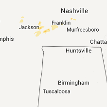
Hail Map for Wednesday, April 15, 2015

Number of Impacted Households on 4/15/2015
0
Impacted by 1" or Larger Hail
0
Impacted by 1.75" or Larger Hail
0
Impacted by 2.5" or Larger Hail
Square Miles of Populated Area Impacted on 4/15/2015
0
Impacted by 1" or Larger Hail
0
Impacted by 1.75" or Larger Hail
0
Impacted by 2.5" or Larger Hail


Cities Most Affected by Hail Storms of 4/15/2015
| Hail Size | Demographics of Zip Codes Affected | ||||||
|---|---|---|---|---|---|---|---|
| City | Count | Average | Largest | Pop Density | House Value | Income | Age |
| Purvis, MS | 2 | 1.88 | 2.00 | 67 | $82k | $37.5k | 35.5 |
| Kenner, LA | 1 | 2.75 | 2.75 | 2636 | $82k | $26.9k | 35.5 |
| Reserve, LA | 1 | 2.00 | 2.00 | 395 | $71k | $34.5k | 37.5 |
| Kentwood, LA | 1 | 1.75 | 1.75 | 44 | $75k | $27.9k | 38.1 |
| New Orleans, LA | 1 | 1.75 | 1.75 | 9020 | $75k | $21.3k | 34.2 |
| Reagan, TN | 1 | 1.75 | 1.75 | 37 | $68k | $30.3k | 39.9 |
| Garyville, LA | 1 | 1.75 | 1.75 | 109 | $53k | $26.8k | 36.5 |
| Braxton, MS | 1 | 1.75 | 1.75 | 23 | $67k | $34.3k | 39.6 |
| Silver Creek, MS | 1 | 1.75 | 1.75 | 21 | $52k | $25.4k | 40.4 |
| La Place, LA | 1 | 1.75 | 1.75 | 687 | $88k | $44.3k | 34.8 |
| Metairie, LA | 1 | 1.75 | 1.75 | 6345 | $152k | $42.5k | 40.3 |
Hail and Wind Damage Spotted on 4/15/2015
Filter by Report Type:Hail ReportsWind Reports
States Impacted
South Carolina, Louisiana, Colorado, Florida, Nebraska, Mississippi, Texas, Tennessee, KansasSouth Carolina
| Local Time | Report Details |
|---|---|
| 2:11 PM EDT | Tree down across steep bottom rd. likely from outflow ahead of thunderstor in hampton county SC, 44.1 miles N of Savannah, GA |
| 3:04 PM EDT | Tree down across road at the corner of gillison branch rd and cypress branch rd. time estimated from rada in jasper county SC, 36.7 miles N of Savannah, GA |
| 3:33 PM EDT | Tree down along interstate 95 near point south. tree took power lines down with it. time estimated from rada in jasper county SC, 39.8 miles NNE of Savannah, GA |
| 3:38 PM EDT | Tree down across pocotaligo rd. time estimated from radar in hampton county SC, 42.9 miles NNE of Savannah, GA |
| 3:43 PM EDT | Oak tree down across road half a mile north of appleton rd on concord church rd. one or two smaller hardwood trees also down in the area. time estimated from radar in allendale county SC, 46.8 miles SE of Augusta, GA |
Louisiana
| Local Time | Report Details |
|---|---|
| 3:27 PM CDT | Quarter sized hail reported near Paulina, LA, 39 miles W of New Orleans, LA |
| 3:46 PM CDT | Golf Ball sized hail reported near Garyville, LA, 33.7 miles WNW of New Orleans, LA, several reports of quarter to golf ball sized hail on social media |
| 3:50 PM CDT | Hen Egg sized hail reported near Reserve, LA, 30.2 miles WNW of New Orleans, LA |
| 3:50 PM CDT | Golf Ball sized hail reported near La Place, LA, 24.8 miles WNW of New Orleans, LA, golf ball sized hail reported to broadcast tv met...estimated time by radar |
| 4:00 PM CDT | Quarter sized hail reported near La Place, LA, 24.8 miles WNW of New Orleans, LA |
| 4:00 PM CDT | Ceiling/roof damage as well as a car moved due to strong thunderstorm winds at st. rose elementary schoo in st. charles county LA, 14.6 miles W of New Orleans, LA |
| 4:30 PM CDT | Storm damage reported in jefferson county LA, 10.5 miles W of New Orleans, LA |
| 4:30 PM CDT | Baseball sized hail reported near Kenner, LA, 10.5 miles W of New Orleans, LA, photo of baseball size hail sent to tv station through social media in kenner. event time based on radar. |
| 4:42 PM CDT | Golf Ball sized hail reported near Metairie, LA, 6.9 miles WNW of New Orleans, LA, golf ball sized hail in kenner and metairie report by jpso |
| 4:50 PM CDT | Powerlines and trees down blocking road in jefferson county LA, 10.5 miles W of New Orleans, LA |
| 5:03 PM CDT | Golf Ball sized hail reported near New Orleans, LA, 1.1 miles N of New Orleans, LA, ham operator reported golf ball sized hail near i-610/i-10 split |
| 5:32 PM CDT | Quarter sized hail reported near Kentwood, LA, 72.2 miles NNW of New Orleans, LA, quarter sized hail reported by kentwood pd |
| 5:40 PM CDT | Golf Ball sized hail reported near Kentwood, LA, 72.2 miles NNW of New Orleans, LA, golf ball size hail reported by fire department in kentwood. |
Colorado
| Local Time | Report Details |
|---|---|
| 3:33 PM MDT | Power outage also reporte in logan county CO, 51.3 miles N of Yuma, CO |
| 3:55 PM MDT | Quarter sized hail reported near Peetz, CO, 61.5 miles NNW of Yuma, CO, pea to quarter size hail |
| 4:25 PM MDT | Storm damage reported in kit carson county CO, 60.8 miles SSE of Yuma, CO |
Florida
| Local Time | Report Details |
|---|---|
| 4:55 PM CDT | County 911 reports trees down from winds estimated at 60mph. intense hail also reported but no information on size at this tim in santa rosa county FL, 52 miles E of Mobile, AL |
Nebraska
| Local Time | Report Details |
|---|---|
| 4:24 PM MDT | Quarter sized hail reported near Sidney, NE, 63.4 miles SE of Scottsbluff, NE, hail was at least quarter sized. |
| 4:35 PM MDT | Storm damage reported in cheyenne county NE, 62.5 miles SE of Scottsbluff, NE |
| 5:25 PM MDT | Quarter sized hail reported near Kimball, NE, 43.6 miles S of Scottsbluff, NE, via facebook. |
| 5:35 PM MDT | Quarter sized hail reported near Lisco, NE, 60.3 miles ESE of Scottsbluff, NE |
Mississippi
| Local Time | Report Details |
|---|---|
| 5:24 PM CDT | Hen Egg sized hail reported near Purvis, MS, 89.4 miles NNE of New Orleans, LA, golfball to hen egg size hail on purvis-columbia road. report and picture relayed via social media. |
| 5:32 PM CDT | Quarter sized hail reported near Purvis, MS, 87.5 miles WNW of Mobile, AL, report of quarter size hail on hwy 589 and purvis oloh road. |
| 5:55 PM CDT | Large blown down reported pike county so in pike county MS, 76.4 miles NNW of New Orleans, LA |
| 6:00 PM CDT | A barn damaged and trees down due to thunderstorm winds in osyk in pike county MS, 76.4 miles NNW of New Orleans, LA |
| 6:07 PM CDT | Quarter sized hail reported near Magnolia, MS, 79.7 miles NNW of New Orleans, LA, reported pike county so |
| 6:17 PM CDT | Quarter sized hail reported near Mccomb, MS, 75.8 miles S of Jackson, MS, quarter sized hail along highway 98 |
| 6:50 PM CDT | Ping Pong Ball sized hail reported near Jayess, MS, 64 miles S of Jackson, MS, report of ping pong size hail northeast of jayess. report and picture relayed via social media. |
| 6:52 PM CDT | Report of powerlines down on pistol ridge road at deavers road. nickel size hail was also reporte in lamar county MS, 83.1 miles WNW of Mobile, AL |
| 6:53 PM CDT | Powerlines downed and a barn roof blown off along deavers rd in lamar county MS, 82.8 miles WNW of Mobile, AL |
| 6:57 PM CDT | Report of powerlines down in the rock hill are in lamar county MS, 81.7 miles WNW of Mobile, AL |
| 6:59 PM CDT | Golf Ball sized hail reported near Purvis, MS, 79.4 miles WNW of Mobile, AL, report of golfball size hail in rock hill. relayed via social media. |
| 6:59 PM CDT | Multiple trees downed along pumping station rd and rockhill rd in forrest county MS, 79.4 miles WNW of Mobile, AL |
| 7:22 PM CDT | Quarter sized hail reported near Monticello, MS, 51.8 miles S of Jackson, MS, report of dime to quarter size hail in monticello. |
| 7:25 PM CDT | Golf Ball sized hail reported near Silver Creek, MS, 51.3 miles SSE of Jackson, MS, report of golfball size hail. report relayed from lawrence county ema. |
| 7:25 PM CDT | Report of tree down on st. stephens road near silver cree in lawrence county MS, 49.3 miles SSE of Jackson, MS |
| 7:25 PM CDT | Quarter sized hail reported near Hattiesburg, MS, 76.9 miles WNW of Mobile, AL, report of quarter size hail in mclaurin. |
| 7:30 PM CDT | Quarter sized hail reported near Newhebron, MS, 34.7 miles S of Jackson, MS, report of quarter size hail in rockport area. |
| 7:35 PM CDT | Report of numerous trees down from from springhill church road to west white sand roa in jefferson davis county MS, 44.1 miles SSE of Jackson, MS |
| 8:00 PM CDT | Quarter sized hail reported near Pearl, MS, 4.6 miles ESE of Jackson, MS, numerous reports dime to quarter size hail in pearl |
| 8:09 PM CDT | Golf Ball sized hail reported near Braxton, MS, 24.1 miles SE of Jackson, MS, report of golfball size hail in cato. |
| 8:10 PM CDT | Quarter sized hail reported near Flowood, MS, 4.4 miles ENE of Jackson, MS, nickel to quarter size hail falling outside the nws jackson office. |
Texas
| Local Time | Report Details |
|---|---|
| 6:59 PM CDT | Storm damage reported in potter county TX, 6.5 miles E of Amarillo, TX |
| 7:20 PM CDT | Quarter sized hail reported near Booker, TX, 63.6 miles W of Woodward, OK |
| 7:23 PM CDT | Ping Pong Ball sized hail reported near Booker, TX, 62.5 miles W of Woodward, OK |
| 7:24 PM CDT | Quarter sized hail reported near Booker, TX, 63.6 miles W of Woodward, OK, nickel to quarter size hail |
| 7:56 PM CDT | Storm damage reported in potter county TX, 23.2 miles N of Amarillo, TX |
Tennessee
| Local Time | Report Details |
|---|---|
| 7:28 PM CDT | Three trees down with up to 4000 people without power south of antioc in davidson county TN, 11.3 miles SSE of Nashville, TN |
| 9:29 PM CDT | Quarter sized hail reported near Huron, TN, 37.4 miles S of Mc Kenzie, TN, quarter sized hail in huron. |
| 9:44 PM CDT | Quarter sized hail reported near Huron, TN, 37.4 miles S of Mc Kenzie, TN, quarter sized hail in huron. |
| 9:44 PM CDT | Quarter sized hail reported near Lexington, TN, 34.1 miles SSE of Mc Kenzie, TN, quarter sized hail in lexington. |
| 10:53 PM CDT | Golf Ball sized hail reported near Reagan, TN, 43.3 miles SSE of Mc Kenzie, TN |
| 1:42 AM CDT | Quarter sized hail reported near Hollow Rock, TN, 15.7 miles ESE of Mc Kenzie, TN, resident reported 2-3 minutes of at least quarter-sized hail |
Kansas
| Local Time | Report Details |
|---|---|
| 6:29 PM MDT | Quarter sized hail reported near Goodland, KS, 46.4 miles WSW of Colby, KS, average stone size was 1/2 inch. |
| 7:35 PM MDT | Quarter sized hail reported near Goodland, KS, 31.9 miles W of Colby, KS |
| 7:35 PM MDT | Half Dollar sized hail reported near Goodland, KS, 31 miles W of Colby, KS |
| 7:43 PM MDT | Storm damage reported in sherman county KS, 27.8 miles W of Colby, KS |
| 9:25 PM CDT | Quarter sized hail reported near Brewster, KS, 18.1 miles W of Colby, KS, mostly nickel sized hail. |
| 9:39 PM CDT | Quarter sized hail reported near Brewster, KS, 17.7 miles W of Colby, KS |
Connect with Interactive Hail Maps