

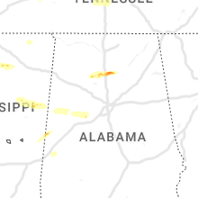
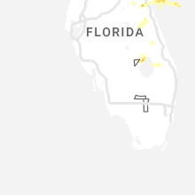
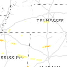
Hail Map for Thursday, April 27, 2023

Number of Impacted Households on 4/27/2023
0
Impacted by 1" or Larger Hail
0
Impacted by 1.75" or Larger Hail
0
Impacted by 2.5" or Larger Hail
Square Miles of Populated Area Impacted on 4/27/2023
0
Impacted by 1" or Larger Hail
0
Impacted by 1.75" or Larger Hail
0
Impacted by 2.5" or Larger Hail


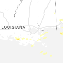
Cities Most Affected by Hail Storms of 4/27/2023
| Hail Size | Demographics of Zip Codes Affected | ||||||
|---|---|---|---|---|---|---|---|
| City | Count | Average | Largest | Pop Density | House Value | Income | Age |
| Lynn Haven, FL | 1 | 1.75 | 1.75 | 2187 | $113k | $47.4k | 40.6 |
| Elkton, FL | 1 | 1.75 | 1.75 | 56 | $105k | $40.2k | 49.0 |
| Panama City, FL | 1 | 1.75 | 1.75 | 124 | $93k | $37.3k | 40.8 |
| Cullman, AL | 1 | 1.75 | 1.75 | 308 | $89k | $30.5k | 39.2 |
| Columbus, MS | 1 | 1.75 | 1.75 | 223 | $102k | $40.9k | 35.3 |
| Hastings, FL | 1 | 1.75 | 1.75 | 45 | $66k | $32.0k | 38.7 |
| Starkville, MS | 1 | 1.75 | 1.75 | 135 | $93k | $25.2k | 25.8 |
Hail and Wind Damage Spotted on 4/27/2023
Filter by Report Type:Hail ReportsWind Reports
States Impacted
Texas, Wyoming, Alabama, Florida, Georgia, Nebraska, Mississippi, Arkansas, Colorado, Tennessee, KansasTexas
| Local Time | Report Details |
|---|---|
| 9:10 AM CDT | Quarter sized hail reported near Hebbronville, TX, 52.7 miles ESE of Laredo, TX, member of the public shared a picture of a hail stone that is estimated to be about quarter-sized in the hebbronville area around 9:10 am cdt. |
| 9:35 AM CDT | Ping Pong Ball sized hail reported near Woodsboro, TX, 31.1 miles N of Corpus Christi, TX, hail was mostly quarter size but some were as large as ping pong balls. |
Wyoming
| Local Time | Report Details |
|---|---|
| 10:35 AM MDT | Awos station kpoy powell airport. wind gusts were associated with vicinity thunderstorms along a strong cold fron in park county WY, 64.7 miles SSW of Billings, MT |
| 12:00 PM MDT | Asos station kwrl worland airport. wind gust was associated with a line of thunderstorms along a strong cold fron in washakie county WY, 68.8 miles NNE of Riverton, WY |
| 2:06 PM MDT | Asos station kcpr casper airport. wind gust occurred with a line of storms along a strong cold fron in natrona county WY, 8 miles WNW of Casper, WY |
Alabama
| Local Time | Report Details |
|---|---|
| 11:47 AM CDT | Quarter sized hail reported near Foley, AL, 29.3 miles SE of Mobile, AL, retired nws employee reports quarter size hail in foley. time using radar. |
| 1:51 AM CDT | Quarter sized hail reported near Cullman, AL, 46.9 miles N of Birmingham, AL, quarter hail near eva rd / cr157. |
| 1:51 AM CDT | Golf Ball sized hail reported near Cullman, AL, 45.5 miles N of Birmingham, AL, hail to golf ball in size east of cullman near us hwy 278. |
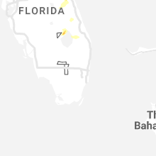
Florida
| Local Time | Report Details |
|---|---|
| 12:02 PM CDT | Quarter sized hail reported near Pensacola, FL, 49.9 miles W of Miramar Beach, FL, pensacola faa tower called to report quarter hail at kpns. |
| 12:06 PM CDT | Quarter sized hail reported near , , 48.3 miles W of Miramar Beach, FL, viewer report of quarter size hail at the intersection of langley and scenic hwy in pensacola... fl. |
| 12:11 PM CDT | Half Dollar sized hail reported near Pensacola, FL, 49.8 miles W of Miramar Beach, FL, multiple reports and videos on social media of half dollar size hail falling in ne pensacola. |
| 12:30 PM CDT | Half Dollar sized hail reported near Panama City Beach, FL, 29.9 miles ESE of Miramar Beach, FL, public reported estimated quarter to half-dollar size hail at the interstection of hwy 79 and 98. |
| 12:35 PM CDT | Report from mping: 1-inch tree limbs broken; shingles blown of in bay county FL, 23.9 miles ESE of Miramar Beach, FL |
| 12:59 PM CDT | Mesonet site recorded wind gust of 58mp in escambia county FL, 48.4 miles W of Miramar Beach, FL |
| 1:02 PM CDT | Ping Pong Ball sized hail reported near Panama City, FL, 41.9 miles E of Miramar Beach, FL, report from mping: ping pong ball (1.50 in.). |
| 1:04 PM CDT | Golf Ball sized hail reported near Lynn Haven, FL, 43.5 miles ESE of Miramar Beach, FL |
| 1:05 PM CDT | Mesonet pensacola beach blvd recorded a wind gust of 59mp in santa rosa county FL, 48.9 miles W of Miramar Beach, FL |
| 1:08 PM CDT | Golf Ball sized hail reported near Panama City, FL, 42.2 miles E of Miramar Beach, FL, there were many reports of hail around this size... including at the eoc. trees and power lines down as well at many locations across the county. |
| 2:29 PM CDT | Tree down on highway 71 south near williams memoria in calhoun county FL, 51.6 miles W of Tallahassee, FL |
| 2:42 PM CDT | Ambient station gusted to 59 mp in bay county FL, 26.6 miles ESE of Miramar Beach, FL |
| 3:50 PM EDT | 2 trees down. 1 medium sized and 1 larger tree uprooted. time radar estimate in duval county FL, 11.6 miles SSW of Jacksonville, FL |
| 3:55 PM EDT | Downed trees along with damaged roof and interior at gas station near 295 and hwy 17. time of event estimated via rada in clay county FL, 10.1 miles SSW of Jacksonville, FL |
| 4:00 PM EDT | Reported tree fell onto house. time estimated from rada in clay county FL, 10.8 miles SSW of Jacksonville, FL |
| 4:00 PM EDT | Quarter sized hail reported near Jacksonville, FL, 9.6 miles SSW of Jacksonville, FL, report of pea to quarter sized hail falling at us 17 and i-295. |
| 3:00 PM CDT | 58 mph gust as station pacf in gmz750 county FL, 44.7 miles ESE of Miramar Beach, FL |
| 3:04 PM CDT | Awos station kpam tyndall af in bay county FL, 51.8 miles ESE of Miramar Beach, FL |
| 3:05 PM CDT | 76 mph wind gusts from bay county sheriff office weatherste in bay county FL, 44 miles ESE of Miramar Beach, FL |
| 4:15 PM EDT | Downed trees... roof damage to supermarket... and 1/4 inch hail reported. time of event estimated via rada in duval county FL, 9.9 miles S of Jacksonville, FL |
| 4:15 PM EDT | Social media. photos of trees down along claire ln and san jose jose blvd in jacksonville... fl. time radar estimate in duval county FL, 10.5 miles S of Jacksonville, FL |
| 4:20 PM EDT | Quarter sized hail reported near Jacksonville, FL, 9.3 miles SSE of Jacksonville, FL, storm report submitted. time estimated from radar. |
| 4:20 PM EDT | Storm report submitted. damage to wooden fence. time estimated from rada in duval county FL, 9.3 miles SSE of Jacksonville, FL |
| 4:24 PM EDT | Awos station knip jacksonville na in duval county FL, 7.7 miles S of Jacksonville, FL |
| 4:00 PM CDT | Several trees down in calhoun count in calhoun county FL, 51.8 miles WSW of Tallahassee, FL |
| 5:10 PM EDT | Golf Ball sized hail reported near Hastings, FL, 43 miles SSE of Jacksonville, FL |
| 5:30 PM EDT | Golf Ball sized hail reported near Elkton, FL, 41.2 miles SSE of Jacksonville, FL, social media submitted video of hail on ground. |
| 5:45 PM EDT | 911 dispatch reports numerous trees down across the entire county due to severe storms moving throug in wakulla county FL, 18.9 miles SSW of Tallahassee, FL |
| 6:00 PM EDT | Fallen trees and limbs resulted in a power outag in wakulla county FL, 13.9 miles S of Tallahassee, FL |
| 6:07 PM EDT | Spotter reports 60 to 70 mph wind gusts. power outage in gadsden county FL, 15 miles WNW of Tallahassee, FL |
| 6:15 PM EDT | Tree down on home in the 2900 block of stokley lan in leon county FL, 5.7 miles NNW of Tallahassee, FL |
| 6:18 PM EDT | Report of downed trees in havann in gadsden county FL, 14.6 miles NNW of Tallahassee, FL |
| 6:20 PM EDT | Trees down on trimble roa in leon county FL, 4.1 miles WNW of Tallahassee, FL |
| 6:20 PM EDT | Trees down on trimble roa in leon county FL, 4.1 miles WNW of Tallahassee, FL |
| 6:25 PM EDT | Trees down meridian and orchard pon in leon county FL, 9.7 miles N of Tallahassee, FL |
| 6:30 PM EDT | Tree down over roadwa in leon county FL, 9.7 miles NNE of Tallahassee, FL |
| 6:30 PM EDT | Tree down across roadway bannerman and tequest in leon county FL, 10.5 miles N of Tallahassee, FL |
| 6:30 PM EDT | Quarter sized hail reported near Cocoa, FL, 35.4 miles ESE of Orlando, FL, spotter reports quarter sized hail in cocoa near adamson rd |
| 6:37 PM EDT | Tree down along us-1 in madison county FL, 31.4 miles ESE of Tallahassee, FL |
| 7:10 PM EDT | Usaf tower ksc-0311 measures wind gust of 52kt/60mph from nw in brevard county FL, 45 miles E of Orlando, FL |
| 7:50 PM EDT | Trees down along ne 118 s in dixie county FL, 88.3 miles SE of Tallahassee, FL |
| 7:50 PM EDT | Numerous trees down along 122 s in dixie county FL, 88.3 miles SE of Tallahassee, FL |
| 7:51 PM EDT | Numerous trees down along se 471 s in dixie county FL, 91.9 miles SE of Tallahassee, FL |
| 7:55 PM EDT | Trees down along se hwy 34 in dixie county FL, 95.1 miles SW of Jacksonville, FL |
| 7:57 PM EDT | Numerous trees down along ne hwy 35 in dixie county FL, 90.6 miles SE of Tallahassee, FL |
| 8:51 PM EDT | Report from mping: 1-inch tree limbs broken; shingles blown of in alachua county FL, 66.6 miles SW of Jacksonville, FL |
| 9:05 PM EDT | Mesonet station fw1789 clearwater beac in pinellas county FL, 37.4 miles NNW of Bradenton, FL |
| 9:14 PM EDT | Asos station kbkv brooksvill in hernando county FL, 65.4 miles W of Orlando, FL |
| 9:15 PM EDT | Mesonet station fw8592 seminol in pinellas county FL, 34.8 miles NNW of Bradenton, FL |
| 9:18 PM EDT | Asos station kpie st pete-clearwater int'' in gmz830 county FL, 29.9 miles NNW of Bradenton, FL |
| 10:30 PM EDT | Emergency manager reports trees down/uprooted... trees on roofs... and structural damage to homes near tavares and oakland par in lake county FL, 28.5 miles NW of Orlando, FL |
| 11:15 PM EDT | Strong winds flipped 3 small planes at merritt island airport (kcoi). report from titusville-cocoa airport authorit in brevard county FL, 44 miles ESE of Orlando, FL |
| 11:37 PM EDT | The asos at melbourne international airport (kmlb) measured a wind gust of 50kts/58mph from the west-northwes in brevard county FL, 54.1 miles SE of Orlando, FL |
Georgia
| Local Time | Report Details |
|---|---|
| 3:45 PM EDT | Received pictures of damage to the metal roof of an outbuilding as well as 2 trees snapped at the top. time estimated from rada in long county GA, 48.2 miles WSW of Savannah, GA |
| 5:15 PM EDT | Corrects previous tstm wnd dmg report from 4 sse thalmann. conveyed report from 911 call center that hwy 99 is shutdown from hwy 32 to hwy 82...due to trees across road in glynn county GA, 61.9 miles N of Jacksonville, FL |
| 6:35 PM EDT | Conveyed report from 911 call center that hwy 99 is shutdown from hwy 32 to hwy 82...due to trees across roadway. gdot in rout in glynn county GA, 61.9 miles N of Jacksonville, FL |
| 7:30 PM EDT | Report from mping: trees uprooted or snapped in brooks county GA, 38.9 miles ENE of Tallahassee, FL |
| 7:30 PM EDT | Report from mping: trees uprooted or snappe in brooks county GA, 39.4 miles ENE of Tallahassee, FL |
| 7:45 PM EDT | Report from mping: 3-inch tree limbs broken; power poles broke in brooks county GA, 48.7 miles ENE of Tallahassee, FL |
| 7:45 PM EDT | Several trees down along madison hw in brooks county GA, 49.3 miles ENE of Tallahassee, FL |
| 7:56 PM EDT | Tree down along rocky ford r in lowndes county GA, 57.3 miles ENE of Tallahassee, FL |
| 7:56 PM EDT | Ambient weather station gusted to 58 mp in lowndes county GA, 57 miles ENE of Tallahassee, FL |
| 7:57 PM EDT | Tree down across adams roa in lowndes county GA, 54.2 miles ENE of Tallahassee, FL |
| 8:12 PM EDT | Trees down in the clyattville are in lowndes county GA, 59.8 miles ENE of Tallahassee, FL |
| 8:14 PM EDT | Tree down near highpoint and blairston in lowndes county GA, 55 miles SSW of Douglas, GA |
Nebraska
| Local Time | Report Details |
|---|---|
| 4:33 PM CDT | Quarter sized hail reported near Tryon, NE, 19.4 miles NNW of North Platte, NE, delayed report. time estimated by radar. |
| 4:46 PM MDT | Delayed report. thunderstorm outflo in chase county NE, 62.3 miles SW of North Platte, NE |
Mississippi
| Local Time | Report Details |
|---|---|
| 4:58 PM CDT | Golf Ball sized hail reported near Starkville, MS, 7 miles NNW of Starkville, MS, golf ball hail occurred along sellers road. |
| 5:43 PM CDT | Quarter sized hail reported near West Point, MS, 13.7 miles ENE of Starkville, MS, hail at old waverly golf course... a few stones up to quarter size. |
| 6:10 PM CDT | Golf Ball sized hail reported near Columbus, MS, 20.8 miles ENE of Starkville, MS, along officers lake rd. |
| 6:13 PM CDT | Trees downed n beasly rd in pheb in clay county MS, 11.7 miles NW of Starkville, MS |
| 6:53 PM CDT | Trees downed east tibbee and old tibbee r in clay county MS, 11.4 miles ENE of Starkville, MS |
| 7:11 PM CDT | Trees down: plymouth buff access rd... old west point rd... taylor thurston rd... and steager r in lowndes county MS, 18.7 miles E of Starkville, MS |
| 7:18 PM CDT | Trees downed on hospital dr... military rd and 7th avenue in lowndes county MS, 22.8 miles E of Starkville, MS |
Arkansas
| Local Time | Report Details |
|---|---|
| 5:17 PM CDT | Quarter sized hail reported near England, AR, 22.5 miles SE of Little Rock, AR |
| 5:28 PM CDT | Quarter sized hail reported near England, AR, 22.5 miles SE of Little Rock, AR |
| 6:39 PM CDT | Half Dollar sized hail reported near Stuttgart, AR, 49.6 miles ESE of Little Rock, AR |
| 6:42 PM CDT | Quarter sized hail reported near Stuttgart, AR, 43.3 miles ESE of Little Rock, AR |
| 7:04 PM CDT | Trees and powerlines dow in monroe county AR, 58.9 miles E of Little Rock, AR |
Colorado
| Local Time | Report Details |
|---|---|
| 4:30 PM MDT | Storm damage reported in yuma county CO, 9 miles SSE of Yuma, CO |
| 4:55 PM MDT | Public report of estimated winds 50-60 mph. time and location estimate in yuma county CO, 34.1 miles SE of Yuma, CO |
| 4:59 PM MDT | Report from mping: 1-inch tree limbs broken; shingles blown of in yuma county CO, 36.9 miles SE of Yuma, CO |
| 5:09 PM MDT | Sustained at 44 mp in yuma county CO, 36.4 miles SE of Yuma, CO |
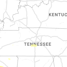
Tennessee
| Local Time | Report Details |
|---|---|
| 6:15 PM CDT | Quarter sized hail reported near Collierville, TN, 20 miles ESE of Memphis, TN |
| 6:32 PM CDT | Quarter sized hail reported near Eads, TN, 21.5 miles E of Memphis, TN |
| 3:13 AM CDT | Quarter sized hail reported near Columbia, TN, 40.5 miles SSW of Nashville, TN, tspotter report of quarter size hail. severe thunderstorm warning in effect at time of report. |
Kansas
| Local Time | Report Details |
|---|---|
| 5:40 PM MDT | Storm damage reported in sherman county KS, 35.1 miles W of Colby, KS |
| 5:43 PM MDT | Off duty nws employee reports 60 mph winds lasting 10-15 minutes and blowing dust resulting in reductions to visibility less than a mil in sherman county KS, 29.1 miles WNW of Colby, KS |
| 5:50 PM MDT | Storm damage reported in sherman county KS, 34.6 miles W of Colby, KS |
| 5:58 PM MDT | Storm damage reported in sherman county KS, 35.1 miles W of Colby, KS |
| 7:31 PM CDT | Storm damage reported in logan county KS, 34.8 miles SW of Colby, KS |
| 7:49 PM CDT | Storm damage reported in logan county KS, 33.4 miles SW of Colby, KS |
| 8:35 PM CDT | Sustained at 47 mp in logan county KS, 23.2 miles SSE of Colby, KS |
Connect with Interactive Hail Maps