

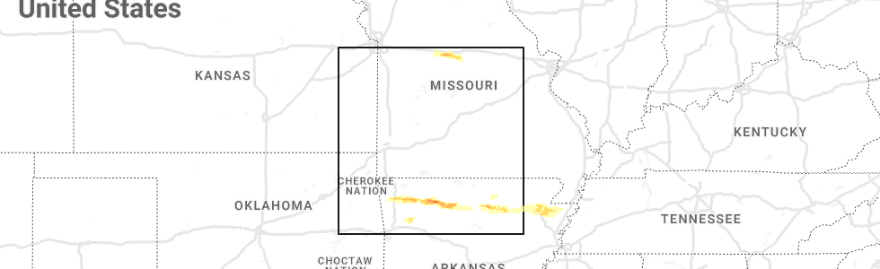
Hail Map for Tuesday, April 5, 2022
Number of Impacted Households on 4/5/2022
0
Impacted by 1" or Larger Hail
0
Impacted by 1.75" or Larger Hail
0
Impacted by 2.5" or Larger Hail
Square Miles of Populated Area Impacted on 4/5/2022
0
Impacted by 1" or Larger Hail
0
Impacted by 1.75" or Larger Hail
0
Impacted by 2.5" or Larger Hail


Cities Most Affected by Hail Storms of 4/5/2022
| Hail Size | Demographics of Zip Codes Affected | ||||||
|---|---|---|---|---|---|---|---|
| City | Count | Average | Largest | Pop Density | House Value | Income | Age |
| Guyton, GA | 2 | 1.75 | 1.75 | 105 | $110k | $46.8k | 35.1 |
| Ellabell, GA | 1 | 2.75 | 2.75 | 82 | $88k | $34.8k | 36.9 |
| Rincon, GA | 1 | 2.00 | 2.00 | 294 | $112k | $51.5k | 34.3 |
| Jasper, AR | 1 | 1.75 | 1.75 | 14 | $54k | $22.5k | 47.8 |
| Leslie, AR | 1 | 1.75 | 1.75 | 9 | $38k | $19.7k | 50.2 |
Hail and Wind Damage Spotted on 4/5/2022
Filter by Report Type:Hail ReportsWind Reports
States Impacted
Mississippi, Alabama, Georgia, Florida, South Carolina, Colorado, Texas, Missouri, North Carolina, ArkansasMississippi
| Local Time | Report Details |
|---|---|
| 7:06 AM CDT | Trees downed on both 13 s and 13 in jefferson davis county MS, 45.1 miles SSE of Jackson, MS |
| 7:18 AM CDT | Corrects time of previous tstm wnd dmg report from 1 wnw newton. line wind damage... several trees downe in newton county MS, 58.6 miles E of Jackson, MS |
| 7:20 AM CDT | Power line down at 591 county road 1 in jasper county MS, 53.2 miles ESE of Jackson, MS |
| 7:26 AM CDT | Tree down near the intersection of vincent rd and lebanon church r in newton county MS, 66.6 miles E of Jackson, MS |
| 7:30 AM CDT | Large tree downe in jones county MS, 74.6 miles SE of Jackson, MS |
| 7:35 AM CDT | Tree down across hwy 9 in franklin county MS, 70.3 miles SW of Jackson, MS |
| 7:48 AM CDT | Tree down on mosby r in lauderdale county MS, 75 miles S of Starkville, MS |
| 7:50 AM CDT | A few trees down between enterprise and stonewal in clarke county MS, 80.8 miles E of Jackson, MS |
| 7:53 AM CDT | Large tree down on palmer rd... near the intersection of palmer rd and hwy 11 in ellisville. report... with picture... relayed via twitte in jones county MS, 74.2 miles SE of Jackson, MS |
| 7:56 AM CDT | Several trees down along hwy 15... about half a mile south of george boutwell r in jones county MS, 82 miles SE of Jackson, MS |
| 7:57 AM CDT | Tree down... blocking s. pine ave in heidelber in jasper county MS, 75.3 miles ESE of Jackson, MS |
| 8:02 AM CDT | Trees down along cr 250... possible tornad in clarke county MS, 79.5 miles ESE of Jackson, MS |
| 8:07 AM CDT | Trees down on cr 277... trees down on homes... possible tornad in clarke county MS, 82.4 miles ESE of Jackson, MS |
| 8:18 AM CDT | Numerous trees snapped and uprooted. a few structures with roof damag in wayne county MS, 82.4 miles NNW of Mobile, AL |
| 8:22 AM CDT | Several trees down on hwy 19... including one on a home. possible tornad in lauderdale county MS, 70.6 miles WNW of Camden, AL |
| 8:36 AM CDT | Numerous trees down in the denham are in wayne county MS, 72.8 miles NNW of Mobile, AL |
| 9:47 AM CDT | Line wind damage... several trees downe in newton county MS, 58.6 miles E of Jackson, MS |
Alabama
| Local Time | Report Details |
|---|---|
| 7:27 AM CDT | Quarter sized hail reported near Wetumpka, AL, 43.1 miles WSW of Auburn, AL |
| 7:51 AM CDT | Quarter sized hail reported near Hope Hull, AL, 53 miles ENE of Camden, AL |
| 8:15 AM CDT | Quarter sized hail reported near Troy, AL, 63.4 miles SSW of Auburn, AL |
| 8:42 AM CDT | Wilcox county emergency management agency relayed a report of trees down on cr 9 near pine hill. time estimated from rada in wilcox county AL, 17.1 miles W of Camden, AL |
| 8:45 AM CDT | Roof damage to several chicken house in washington county AL, 70 miles WSW of Camden, AL |
| 9:30 AM CDT | Numerous trees down in the grove hill are in clarke county AL, 34.3 miles SW of Camden, AL |
| 9:47 AM CDT | Wilcox county emergency management agency reports trees down at camden bypass and dees & packer roa in wilcox county AL, 10.9 miles SW of Camden, AL |
| 10:04 AM CDT | Broadcast media relayed a report of trees down and blocking parts of highway 21 near the peterman and tunnel springs area. time estimated from rada in monroe county AL, 25.8 miles S of Camden, AL |
| 10:30 AM CDT | Trees down blocking wilkinson r in butler county AL, 31.1 miles ESE of Camden, AL |
| 10:45 AM CDT | Trees blocking road at highway 31 and waverly l in butler county AL, 41 miles SE of Camden, AL |
| 10:50 AM CDT | Trees down on harrogate springs r in elmore county AL, 41.7 miles W of Auburn, AL |
| 10:51 AM CDT | Trees down blocking road at old stage rd and highway 18 in butler county AL, 39.5 miles E of Camden, AL |
| 10:54 AM CDT | Crenshaw county ema reports structural damage to a church near shady grove rd and lapine hwy. time estimated from rada in crenshaw county AL, 64 miles E of Camden, AL |
| 10:55 AM CDT | Possible tornado. trees down across firetower r in elmore county AL, 38.1 miles W of Auburn, AL |
| 10:57 AM CDT | Trees blocking road at ft. deposit rd and highway 3 in butler county AL, 45.4 miles E of Camden, AL |
| 11:06 AM CDT | Shingles off of home and damage to a storage building. time estimated by rada in crenshaw county AL, 58.3 miles ESE of Camden, AL |
| 11:07 AM CDT | Crenshaw county ema county reports several trees down throughout the count in crenshaw county AL, 59.3 miles ESE of Camden, AL |
| 11:14 AM CDT | Trees down on hwy 229. possible tornad in elmore county AL, 27.3 miles W of Auburn, AL |
| 11:15 AM CDT | Structural damage to a church near the intersection of shady grove rd and lapine hwy. in addition... damage reported to nearby chicken houses at the intersection of sha in crenshaw county AL, 64 miles E of Camden, AL |
| 11:15 AM CDT | Possible tornado. trees and houses damaged on wildlife r in tallapoosa county AL, 20.2 miles WNW of Auburn, AL |
| 11:16 AM CDT | Possible tornado. trailer damage on hwy 23 in montgomery county AL, 50.3 miles SW of Auburn, AL |
| 11:20 AM CDT | Debris down across road at mm 90. possible tornad in montgomery county AL, 50.2 miles SW of Auburn, AL |
| 11:52 AM CDT | Barn destroyed and 20 or more trees uprooted and snapped. about a quarter mile of damage on bullock cr14. possible tornad in bullock county AL, 43.8 miles SSW of Auburn, AL |
| 11:55 AM CDT | Trees down on baggett st. time estimated from rada in escambia county AL, 54.4 miles SSE of Camden, AL |
| 12:14 PM CDT | Tree down along highway 51 north in coffee county AL, 79 miles SSW of Auburn, AL |
| 12:55 PM CDT | A few downed trees were reporte in coffee county AL, 71.2 miles NNE of Miramar Beach, FL |
| 1:33 PM CDT | Trees were blown down in the tumbleton area in henry county AL, 83.5 miles S of Auburn, AL |
| 1:50 PM CDT | Fence and tree damage was reported in the malvern area in geneva county AL, 72.7 miles NE of Miramar Beach, FL |
| 1:52 PM CDT | Large trees were blown down in the rehobeth area in houston county AL, 75.5 miles NE of Miramar Beach, FL |
| 1:52 PM CDT | Large trees were blown down in the rehobeth area in houston county AL, 75.5 miles NE of Miramar Beach, FL |
| 1:56 PM CDT | Large trees were blown down in the cowarts area in houston county AL, 80.5 miles NW of Tallahassee, FL |
| 1:56 PM CDT | Tree down near jester street and cherry street intersection in houston county AL, 81 miles NW of Tallahassee, FL |
| 2:07 PM CDT | Large trees were blown down in the ashford area in houston county AL, 76.5 miles NW of Tallahassee, FL |
| 2:08 PM CDT | Tree down on dusty lane in houston county AL, 75.7 miles NW of Tallahassee, FL |
| 2:10 PM CDT | Tree down near 1800 east cook road in houston county AL, 72.1 miles NW of Tallahassee, FL |
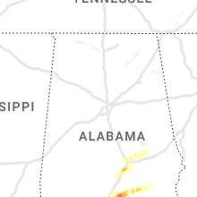
Georgia
| Local Time | Report Details |
|---|---|
| 10:14 AM EDT | Half Dollar sized hail reported near Barnesville, GA, 52.9 miles SSE of Atlanta, GA, half dollar sized hail reported at the marathon gas station. |
| 2:08 PM EDT | Tornado possibl in stewart county GA, 53.7 miles SE of Auburn, AL |
| 3:08 PM EDT | Trained spotter reported trees and powerlines down south of blakely on ga highway 39 in early county. estimated time at 3:08pm. possible tornad in early county GA, 69.6 miles NNW of Tallahassee, FL |
| 3:15 PM EDT | Trained spotter reported trees and powerlines down around 16480 damascus-hilton road in early county. estimated time at 3:15pm. possible tornad in early county GA, 66.2 miles NNW of Tallahassee, FL |
| 3:19 PM EDT | Possible tornado. roof torn off a lean-to house. a barn was flattened. about 50 yards north of the miller county lin in early county GA, 66.5 miles NNW of Tallahassee, FL |
| 3:23 PM EDT | A tree was blown down on womble road in miller county GA, 63.2 miles NNW of Tallahassee, FL |
| 3:35 PM EDT | 40 trees reported down across a large swath of baker count in baker county GA, 57.7 miles NNW of Tallahassee, FL |
| 3:35 PM EDT | Screven county 911 center reported 2 trees down at pine grove inn road and burton's ferry road. this was due to a possible tornad in screven county GA, 50.2 miles SSE of Augusta, GA |
| 3:40 PM EDT | Wires were blown down in the colquitt area in miller county GA, 57 miles NNW of Tallahassee, FL |
| 3:59 PM EDT | Uga weather network station at camilla reported a 59.6 mph gust in mitchell county GA, 58.6 miles N of Tallahassee, FL |
| 4:06 PM EDT | Multiple trees down across the county roughly in a line from us hwy 19 near the tyson chicken plan to north of sale cit in mitchell county GA, 54 miles N of Tallahassee, FL |
| 4:10 PM EDT | A transformer was blown at 2400 mlk jr dr in dougherty county GA, 78.7 miles W of Douglas, GA |
| 4:10 PM EDT | Numerous trees and powerlines down along highway 44 in baldwin county GA, 76.8 miles ESE of Atlanta, GA |
| 4:12 PM EDT | Mobile home roof damage and trees down near ga-112 and greenough road. possible tornado. time estimated by rada in mitchell county GA, 61.6 miles N of Tallahassee, FL |
| 4:18 PM EDT | A structure sustained light damage as metal siding was torn of in mitchell county GA, 61.2 miles NNE of Tallahassee, FL |
| 4:20 PM EDT | Tree down across highway 93 near sale city in mitchell county GA, 59.3 miles NNE of Tallahassee, FL |
| 4:22 PM EDT | Tree fell on an occupied vehicle on sharpe street at scott street. power lines down. time estimated by rada in decatur county GA, 37 miles NNW of Tallahassee, FL |
| 4:24 PM EDT | Tree blocking roadway on bridgeboro anderson city road 2 miles west of evergreen road. time estimated by rada in worth county GA, 63.1 miles W of Douglas, GA |
| 4:25 PM EDT | Tree down at bridgeboro/anderson city road and hwy 133 in worth county GA, 64.8 miles W of Douglas, GA |
| 4:25 PM EDT | Tree down at bridgeboro/anderson city road and mobley roa in worth county GA, 63.6 miles W of Douglas, GA |
| 4:27 PM EDT | Tree down at bridgeboro/anderson city road and evergreen roa in worth county GA, 61.4 miles W of Douglas, GA |
| 4:44 PM EDT | Tree down at paulks chapel road and bethel church road in worth county GA, 51.5 miles WSW of Douglas, GA |
| 4:44 PM EDT | Power line across the highway at hwy 256 and bethel church roa in worth county GA, 50.4 miles WSW of Douglas, GA |
| 4:46 PM EDT | Power line across the highway at hwy. 256 at bethel church r in worth county GA, 50.4 miles WSW of Douglas, GA |
| 4:48 PM EDT | Powerlines were reported down at ridge ave s and 13th street and mullis rd and alabama av in tift county GA, 39.2 miles W of Douglas, GA |
| 4:48 PM EDT | Powerlines were reported down at ridge ave s and 13th street and mullis rd and alabama av in tift county GA, 39.2 miles W of Douglas, GA |
| 4:51 PM EDT | Tree down at pulks chapel road and behel church road in worth county GA, 51.2 miles W of Douglas, GA |
| 4:51 PM EDT | The evans county 911 center reported a tree down on south grady street. time estimated based on rada in evans county GA, 48.4 miles W of Savannah, GA |
| 5:22 PM EDT | 1 metal outdoor structure damaged with trees and powerlines down near the intersection of campground rd and hwy 80 in jefferson county GA, 28.6 miles SW of Augusta, GA |
| 5:25 PM EDT | Five trees down along hwy 341 between akin road and wire road. some trees fell on powerlines. time estimated by rada in wayne county GA, 56.1 miles SW of Savannah, GA |
| 5:25 PM EDT | Baseball sized hail reported near Ellabell, GA, 24.2 miles WNW of Savannah, GA, damage reported to vehicles. |
| 5:33 PM EDT | Effingham warning point reported tree down on courthouse road near the lonesome oak neighborhoo in effingham county GA, 20.5 miles NW of Savannah, GA |
| 5:35 PM EDT | Golf Ball sized hail reported near Guyton, GA, 22.7 miles NW of Savannah, GA |
| 5:38 PM EDT | Couple trees and power lines down on register road in cook county GA, 36.6 miles SW of Douglas, GA |
| 5:40 PM EDT | Multiple trees reported down by 911 call center throughout metro august in richmond county GA, 1.6 miles WSW of Augusta, GA |
| 5:42 PM EDT | Tree down on power lines. lines down 400 block of leitner mill rd. time estimated by rada in columbia county GA, 18.4 miles WSW of Augusta, GA |
| 5:45 PM EDT | Tattnall county 911 center reported a tree blown down near the intersection of lynntown road and live oak street. time was estimated from radar dat in tattnall county GA, 61.2 miles W of Savannah, GA |
| 5:45 PM EDT | Hen Egg sized hail reported near Rincon, GA, 18.1 miles NNW of Savannah, GA, 2 inch hail reported near the ymca in rincon ga. |
| 5:46 PM EDT | Golf Ball sized hail reported near Guyton, GA, 22.7 miles NW of Savannah, GA |
| 5:58 PM EDT | Bulloch county 911 center reported numerous trees blown down in statesboro. several trees fell on structures. a metal roof was blown off a building on highway 30 in bulloch county GA, 47.7 miles WNW of Savannah, GA |
| 6:12 PM EDT | Power lines down on 11th street in lakeland. time estimated by rada in lanier county GA, 34.6 miles SSW of Douglas, GA |
| 7:37 PM EDT | Warning point reported tree down on blounts crossing between cypress street and palmetto stree in mcintosh county GA, 51.2 miles SSW of Savannah, GA |
Florida
| Local Time | Report Details |
|---|---|
| 1:20 PM CDT | Trees were reported down on the north side of the county in walton county FL, 36.6 miles NNE of Miramar Beach, FL |
| 1:44 PM CDT | Measured by kce in okaloosa county FL, 29.5 miles NNW of Miramar Beach, FL |
| 1:50 PM CDT | Several trees down on roads. one house had a section of old tin roof blown awa in holmes county FL, 56.6 miles NE of Miramar Beach, FL |
| 2:15 PM CDT | The roof of a pole barn was destroyed along smokey road in jackson county FL, 63.3 miles NE of Miramar Beach, FL |
| 2:20 PM CDT | Several trees and power lines were blown down across washington county in washington county FL, 42.3 miles ENE of Miramar Beach, FL |
| 2:38 PM CDT | Trees fell on power lines across from williams monument on highway 90 west in jackson county FL, 65.7 miles WNW of Tallahassee, FL |
| 5:22 PM EDT | Trees down at deer lake west and hunters ridge trail and at deer lake west and folkstone road. time estimated by rada in leon county FL, 10.3 miles NNE of Tallahassee, FL |
| 5:32 PM EDT | Trees down at deer lake west and hunters ridge trail and at deer lake west and folkstone road. time estimated by rada in leon county FL, 10.3 miles NNE of Tallahassee, FL |
| 6:02 PM EDT | Tree down blocking westbound lane on us 90 and south salt r in jefferson county FL, 31.4 miles E of Tallahassee, FL |
South Carolina
| Local Time | Report Details |
|---|---|
| 2:45 PM EDT | 911 call center reported large tree blocked roadway and brought powerlines down on golf course rd near hwy 9 in greenwood county SC, 46.5 miles N of Augusta, GA |
| 4:25 PM EDT | County official relayed report of a tree blown down near the intersection of oak forest drive and chinquapin roa in greenwood county SC, 49.8 miles SSE of Greenville, SC |
| 4:32 PM EDT | 911 center reports a tree blown down on powerlines near hwy 25 south and lamb roa in greenwood county SC, 36.8 miles N of Augusta, GA |
| 5:08 PM EDT | Reported wind damage to solar farm along hwy 210 sw of bowman. time estimated by radar. rotation reported during even in orangeburg county SC, 40.4 miles WNW of Charleston, SC |
| 5:49 PM EDT | Tree down in the vicinity of the intersection of indian branch road and wesley chapel roa in darlington county SC, 74.2 miles N of Charleston, SC |
| 6:23 PM EDT | Social media report from the public of trees down and a possible tornado on dixon rd. near the lexington-calhoun county line. time estimated by rada in calhoun county SC, 59.4 miles ENE of Augusta, GA |
| 6:30 PM EDT | South carolina highway patrol reported a tree down near the intersection of southern charm road and azalea patch roa in colleton county SC, 48.7 miles WSW of Charleston, SC |
| 6:37 PM EDT | South carolina highway patrol reported a tree down near the intersection of ruffin road and jones swamp road. time estimated from radar dat in colleton county SC, 43.6 miles WSW of Charleston, SC |
| 6:47 PM EDT | Schp reported trees in roadway bazzle road and sc641. time estimated by rada in bamberg county SC, 60 miles ESE of Augusta, GA |
| 6:54 PM EDT | Colleton county emergency management reported tree down at lowcountry highway and cane branch roa in colleton county SC, 53.6 miles WSW of Charleston, SC |
| 7:01 PM EDT | Colleton county emergency management reported road blocked due to tree down at lowcountry highway and buckhead roa in colleton county SC, 46.3 miles W of Charleston, SC |
| 7:02 PM EDT | Colleton county emergency management reported tree and power lines down at lowcountry highway and phoenix circl in colleton county SC, 46.4 miles W of Charleston, SC |
| 7:09 PM EDT | Beaufort county warning point reported wires down at the 3700 block of okatie highwa in beaufort county SC, 12.5 miles NNE of Savannah, GA |
| 7:10 PM EDT | Beaufort warning point reported tree and powerlines down at okatie highway and evan wa in beaufort county SC, 12.7 miles NNE of Savannah, GA |
| 7:10 PM EDT | Dorchester warning point reported tree down at 500 block of cross creek roa in dorchester county SC, 36.4 miles W of Charleston, SC |
| 7:12 PM EDT | Beaufort county warning point reported tree down on powerlines at 64 butler farm roa in beaufort county SC, 38.9 miles NNE of Savannah, GA |
| 7:15 PM EDT | Beaufort county warning point reported tree down at roseida road and stroman lan in beaufort county SC, 32.3 miles NE of Savannah, GA |
| 7:15 PM EDT | Dorchester warning point reported tree down at 500 block of mount zion roa in dorchester county SC, 32.9 miles W of Charleston, SC |
| 7:15 PM EDT | Dorchester warning point reported tree down at 100 block of gum branch roa in dorchester county SC, 29.5 miles W of Charleston, SC |
| 7:15 PM EDT | Storm damage reported in colleton county SC, 41.1 miles WSW of Charleston, SC |
| 7:16 PM EDT | Dorchester warning point reported tree down at enoch lane at wagers driv in dorchester county SC, 30.1 miles W of Charleston, SC |
| 7:16 PM EDT | Beaufort county warning point reported powerlines down at pleasant farm drive and saluda wa in beaufort county SC, 29.4 miles NE of Savannah, GA |
| 7:18 PM EDT | Dorchester warning point reported tree down at 800 block of st paul roa in dorchester county SC, 27.1 miles W of Charleston, SC |
| 7:18 PM EDT | Dorchester warning point reported tree down at 1800 block of highway 15 sout in dorchester county SC, 34 miles W of Charleston, SC |
| 7:19 PM EDT | Beaufort county warning point reported tree down at darby drive and sycamore street...and tree and wires down at 1800 block of morris stree in beaufort county SC, 34.6 miles NE of Savannah, GA |
| 7:22 PM EDT | Dorchester warning point reported tree down at second bend road near addison roa in dorchester county SC, 23.7 miles W of Charleston, SC |
| 7:23 PM EDT | Em reported tree down on a house and car on dingle pond road. time estimated based on rada in clarendon county SC, 31.5 miles NW of Charleston, SC |
| 7:25 PM EDT | South carolina highway patrol reported a tree down on interstate 95 near mile marker 73n in dorchester county SC, 36 miles W of Charleston, SC |
| 7:25 PM EDT | Large pecan tree uprooted. 8 inch tree branches broken... damage to houses at 267 e. main street. tops of trees broken. possible tornad in dorchester county SC, 25.4 miles W of Charleston, SC |
| 7:39 PM EDT | A large tree was blocking state route 165 near the long island road intersection. tim was estimated from radar dat in charleston county SC, 36.5 miles SSW of Charleston, SC |
| 7:45 PM EDT | Large tree blown down blocking hwy 165 at long island road. state maintenance has been notifie in charleston county SC, 35.4 miles SSW of Charleston, SC |
| 7:45 PM EDT | One foot diameter limb down along chisholm rd on johns islan in charleston county SC, 31.5 miles SSW of Charleston, SC |
| 7:48 PM EDT | Social media report of trees down on brownswood roa in charleston county SC, 31.7 miles S of Charleston, SC |
| 7:55 PM EDT | Horry fire dept reports part of porch/shed roof blown off and fell on nearby vehicle on gunters island r in horry county SC, 67 miles NE of Charleston, SC |
| 7:55 PM EDT | Tree down on pee dee rd near clay hill rd and juniper bay rd near dog bluff. time estimated via rada in horry county SC, 65.4 miles NE of Charleston, SC |
| 8:00 PM EDT | Awendaw-mcclellanville fire department reported trees down on the 1200 block of hamlin roa in charleston county SC, 26.9 miles SSE of Charleston, SC |
| 8:00 PM EDT | Storm damage reported in amz330 county SC, 30 miles SSE of Charleston, SC |
| 8:03 PM EDT | Awendaw-mcclellanville fire department reported tree down at halfway creek roa in berkeley county SC, 20.6 miles SE of Charleston, SC |
| 8:05 PM EDT | Storm damage reported in amz330 county SC, 31.9 miles SSE of Charleston, SC |
| 8:07 PM EDT | Storm damage reported in amz350 county SC, 31.5 miles SSE of Charleston, SC |
| 8:10 PM EDT | Sc highway patrol reports tree down at bradley bay rd and dewey cox rd. time estimated via rada in williamsburg county SC, 46.1 miles NNE of Charleston, SC |
| 8:11 PM EDT | Awendaw-mcclellanville fire department reported tree down at halfway creek road and steed creek roa in berkeley county SC, 20.9 miles ESE of Charleston, SC |
| 8:39 PM EDT | Sc highway patrol reports tree on roadway at highway 9 and snow cour in marion county SC, 61.4 miles NE of Charleston, SC |
| 8:49 PM EDT | Measured at 50 foot height in amz256 county SC, 48.3 miles E of Charleston, SC |
| 9:00 PM EDT | Sc highway patrol reports tree down in roadway at knollwood dr and edgewood dr. time estimated via rada in horry county SC, 65.3 miles ENE of Charleston, SC |
| 9:10 PM EDT | Buoy 41004 reported a 54 knot wind gus in amz370 county SC, 71.6 miles SE of Charleston, SC |
| 9:25 PM EDT | Weather station along the coast in cherry grove... sc measured a wind gust of 59mp in horry county SC, 46.8 miles SW of Wilmington, NC |
Colorado
| Local Time | Report Details |
|---|---|
| 2:10 PM MDT | Report from mping: 1-inch tree limbs broken; shingles blown of in adams county CO, 19.5 miles NNE of Denver, CO |
Texas
| Local Time | Report Details |
|---|---|
| 3:20 PM CDT | Corrects previous tstm wnd gst report from 9 s el indio. 62mph wind gust and nickel sized hai in maverick county TX, 76.3 miles NW of Laredo, TX |
| 4:54 PM CDT | Correction to location. small to medium size branches broken in la salle county TX, 48.4 miles N of Laredo, TX |
| 4:54 PM CDT | Small to medium size branches broken in refugio county TX, 53.5 miles NE of Corpus Christi, TX |
| 6:38 PM CDT | Raws station gwrt2 in george west reported a wind gust of 60 mph. time estimated by rada in live oak county TX, 58.9 miles NW of Corpus Christi, TX |
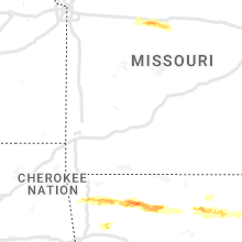
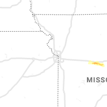
Missouri
| Local Time | Report Details |
|---|---|
| 7:32 PM CDT | Estimated wind gust of 70-80 mph from ham radio operato in cooper county MO, 29.4 miles W of Columbia, MO |
| 7:35 PM CDT | Quarter sized hail reported near Lewistown, MO, 23.2 miles S of Kahoka, MO, spotter reported at least quarter size hail in lewistown. |
| 7:35 PM CDT | Power lines blown over on highway 135. barn missing part of a roo in cooper county MO, 31.2 miles W of Columbia, MO |
| 8:05 PM CDT | Quarter sized hail reported near La Grange, MO, 28.1 miles SSE of Kahoka, MO, media passed report from spotter of quarter-sized hail. |
| 9:04 PM CDT | Asos station kjef jefferson cit in callaway county MO, 26.3 miles SSE of Columbia, MO |
North Carolina
| Local Time | Report Details |
|---|---|
| 10:18 PM EDT | Measured at 50 foot height in new hanover county NC, 19 miles S of Wilmington, NC |
Arkansas
| Local Time | Report Details |
|---|---|
| 11:40 PM CDT | Quarter sized hail reported near Fayetteville, AR, 50.1 miles NNE of Fort Smith, AR |
| 12:30 AM CDT | Quarter sized hail reported near Compton, AR, 70.5 miles NE of Fort Smith, AR |
| 12:38 AM CDT | Quarter sized hail reported near Kingston, AR, 69.6 miles NE of Fort Smith, AR, report from mping: quarter (1.00 in.). |
| 12:40 AM CDT | Quarter sized hail reported near Ponca, AR, 73.6 miles NE of Fort Smith, AR |
| 12:50 AM CDT | Quarter sized hail reported near Jasper, AR, 81.6 miles ENE of Fort Smith, AR, quarter size hail covering the ground at jasper. |
| 12:50 AM CDT | Golf Ball sized hail reported near Jasper, AR, 81.6 miles ENE of Fort Smith, AR, quarter to golf ball size hail covering the ground at jasper. |
| 1:05 AM CDT | Half Dollar sized hail reported near Jasper, AR, 83.2 miles S of Springfield, MO |
| 1:50 AM CDT | Golf Ball sized hail reported near Leslie, AR, 76.4 miles N of Little Rock, AR |
| 4:10 AM CDT | Quarter sized hail reported near Jonesboro, AR, 58.7 miles NW of Memphis, TN |
| 4:30 AM CDT | Quarter sized hail reported near Lake City, AR, 51.4 miles NNW of Memphis, TN |
Connect with Interactive Hail Maps