

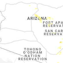
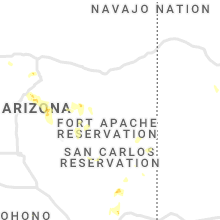
Hail Map for Saturday, August 1, 2020

Number of Impacted Households on 8/1/2020
0
Impacted by 1" or Larger Hail
0
Impacted by 1.75" or Larger Hail
0
Impacted by 2.5" or Larger Hail
Square Miles of Populated Area Impacted on 8/1/2020
0
Impacted by 1" or Larger Hail
0
Impacted by 1.75" or Larger Hail
0
Impacted by 2.5" or Larger Hail


Cities Most Affected by Hail Storms of 8/1/2020
| Hail Size | Demographics of Zip Codes Affected | ||||||
|---|---|---|---|---|---|---|---|
| City | Count | Average | Largest | Pop Density | House Value | Income | Age |
| Red Feather Lakes, CO | 1 | 1.75 | 1.75 | 2 | $141k | $35.4k | 58.0 |
Hail and Wind Damage Spotted on 8/1/2020
Filter by Report Type:Hail ReportsWind Reports
States Impacted
North Carolina, Kansas, Colorado, Ohio, New Mexico, Wyoming, Texas, Iowa, West Virginia, Arizona, Virginia, Oklahoma, Maryland, PennsylvaniaNorth Carolina
| Local Time | Report Details |
|---|---|
| 2:55 PM EDT | Beaufort county sheriffs department relayed report of powerlines and power poles down in aurora near the intersection of hwy 33 and 306. also damage to a restaurant roo in beaufort county NC, 98.7 miles NE of Wilmington, NC |
| 4:11 PM EDT | Wxflow sensor on the alligator river bridge observed a 55 knot marine thunderstorm wind gus in amz131 county NC, 59 miles S of Virginia Beach, VA |
| 4:33 PM EDT | Corrects previous tstm wnd dmg report from 1 w pine level. two power lines down at u.s. highway 70a and catherine s in johnston county NC, 28.7 miles SE of Raleigh, NC |
| 4:34 PM EDT | Large tree down at nc highway 231 and richardson r in johnston county NC, 20.7 miles E of Raleigh, NC |
| 4:44 PM EDT | One tree down at nc highway 96n and covered bridge r in johnston county NC, 20.5 miles ESE of Raleigh, NC |
| 5:20 PM EDT | Two power lines down at u.s. highway 70a and catherine s in johnston county NC, 28.7 miles SE of Raleigh, NC |
Kansas
| Local Time | Report Details |
|---|---|
| 3:25 PM CDT | Quarter sized hail reported near Grainfield, KS, 41.6 miles SE of Colby, KS |
| 3:30 PM CDT | Half Dollar sized hail reported near Grainfield, KS, 41.6 miles SE of Colby, KS |
| 4:04 PM CDT | Wind driven rain with hail resulting in significantly reduced visibility. time estimated from rada in logan county KS, 21.2 miles SSE of Colby, KS |
| 4:35 PM CDT | Power poles were blown down along highway 23 near county road 16 in lane county KS, 42.7 miles NNE of Garden City, KS |
| 4:40 PM CDT | *** 1 inj *** a building was heavily damaged 1.5 miles west of dighton. powerpoles were also down at this location. a vehicle had its windows blown out at this location in lane county KS, 40.9 miles NNE of Garden City, KS |
Colorado
| Local Time | Report Details |
|---|---|
| 2:31 PM MDT | Asos station kdro durango la plata cnty airpor in la plata county CO, 37.8 miles NE of Farmington, NM |
| 6:41 PM MDT | Quarter sized hail reported near Red Feather Lakes, CO, 35.3 miles S of Laramie, WY, delayed report. |
| 6:44 PM MDT | Ping Pong Ball sized hail reported near Red Feather Lakes, CO, 37.8 miles S of Laramie, WY, delayed report. |
| 6:58 PM MDT | Quarter sized hail reported near Livermore, CO, 39.5 miles SSE of Laramie, WY |
| 6:58 PM MDT | Golf Ball sized hail reported near Red Feather Lakes, CO, 35.7 miles S of Laramie, WY, hail was 1.5 to 1.75 inches in diameter. delayed report. |
Ohio
| Local Time | Report Details |
|---|---|
| 4:38 PM EDT | Tree down along state route 139 in jackson in jackson county OH, 66 miles SSE of Columbus, OH |
| 4:40 PM EDT | Tree down at fairgreens road and keenan road. time estimated from radar in jackson county OH, 66.3 miles SSE of Columbus, OH |
| 4:56 PM EDT | Reports of several trees down along keystone road outside the town of vinton in gallia county OH, 60.2 miles NW of Charleston, WV |
New Mexico
| Local Time | Report Details |
|---|---|
| 2:57 PM MDT | Kcqc aso in torrance county NM, 56.4 miles E of Albuquerque, NM |
| 6:25 PM MDT | Mp 12 obs site. wind gust from thunderstorm moving down from the nort in hidalgo county NM, 47.5 miles SW of Silver City, NM |
| 7:55 PM MDT | Wsmr mesonet site rita. thunderstorm moved down from the nort in otero county NM, 92.4 miles W of Roswell, NM |
Wyoming
| Local Time | Report Details |
|---|---|
| 3:10 PM MDT | Half Dollar sized hail reported near Kaycee, WY, 47.7 miles NNW of Casper, WY |
| 5:12 PM MDT | Quarter sized hail reported near Laramie, WY, 2 miles NE of Laramie, WY |
Texas
| Local Time | Report Details |
|---|---|
| 4:13 PM CDT | Measured by the west texas mesonet in garza county TX, 58 miles SE of Lubbock, TX |
| 6:10 PM CDT | Storm damage reported in howard county TX, 72.2 miles ENE of Odessa, TX |
Iowa
| Local Time | Report Details |
|---|---|
| 5:45 PM CDT | Trees down near the intersection of eastern and hammond in red oa in montgomery county IA, 41.9 miles ESE of Omaha, NE |
West Virginia
| Local Time | Report Details |
|---|---|
| 6:48 PM EDT | Tree and power lines down along ely fork road near sumerco in lincoln county WV, 16.8 miles WSW of Charleston, WV |
| 6:49 PM EDT | Trees took down powerline in lincoln county WV, 15.4 miles SW of Charleston, WV |
| 7:02 PM EDT | Tree down along brounland road in alum creek area in kanawha county WV, 9.5 miles SW of Charleston, WV |
| 7:12 PM EDT | Approx 650 customers without power due to powerlines taken down from stor in kanawha county WV, 2.4 miles NNW of Charleston, WV |
| 7:20 PM EDT | Trees down on egypt ridg in roane county WV, 40.4 miles NNE of Charleston, WV |
| 7:25 PM EDT | Tree down along route 5 west on annamoriah hill in calhoun county WV, 46.3 miles NNE of Charleston, WV |
| 7:50 PM EDT | Tree down on house on powerline rd in beckley. also a report of a tree down on the post office in hele in raleigh county WV, 46.6 miles SSE of Charleston, WV |
| 8:06 PM EDT | A few trees were reported down in the great cacapon are in morgan county WV, 84.1 miles SSW of State College, PA |
| 8:20 PM EDT | Numerous trees down in the 3000 block of hancock road in morgan county WV, 80.4 miles SSW of State College, PA |
| 8:24 PM EDT | Tree down near the intersection of 1st church street and pratt street in morgan county WV, 83.3 miles SSW of State College, PA |
| 8:36 PM EDT | Numerous trees down near the intersection of mable lane and south washington street in morgan county WV, 83.3 miles SSW of State College, PA |
| 8:47 PM EDT | Trees down in reynoldsville in harrison county WV, 40.3 miles NW of Elkins, WV |
| 9:02 PM EDT | Tree down on lumberport road in spelter in harrison county WV, 38.9 miles NW of Elkins, WV |
| 9:07 PM EDT | Tree down on lumberport road in harrison county WV, 41 miles NW of Elkins, WV |
| 9:11 PM EDT | Tree blocking rt 19 in shinnston and tree blown down on landing way in shinnston in harrison county WV, 40.4 miles NW of Elkins, WV |
| 9:14 PM EDT | Three fire depts responded to trees down in enterprise in harrison county WV, 41.4 miles NW of Elkins, WV |
Arizona
| Local Time | Report Details |
|---|---|
| 4:35 PM MST | Quarter sized hail reported near Peridot, AZ, 70 miles SSW of Show Low, AZ, quarter size hail reported. unknown duration of hail event. |
| 4:35 PM MST | Corrects previous tstm wnd dmg report from 23 wnw bylas. down electrical power lines in the town of peridot... az. impacting multiple neighborhood in graham county AZ, 70.2 miles SSW of Show Low, AZ |
| 5:20 PM MST | Quarter sized hail reported near Camp Verde, AZ, 48 miles SSW of Flagstaff, AZ, on silver road. |
| 7:09 PM MST | Down electrical power lines in the town of peridot... az. impacting multiple neighborhood in graham county AZ, 70.2 miles SSW of Show Low, AZ |
Virginia
| Local Time | Report Details |
|---|---|
| 8:20 PM EDT | Several trees reported down along david bruce ave. in charlotte courthous in charlotte county VA, 63 miles WSW of Richmond, VA |
Oklahoma
| Local Time | Report Details |
|---|---|
| 7:25 PM CDT | Time and location are approximat in caddo county OK, 57.5 miles WSW of Oklahoma City, OK |
| 7:50 PM CDT | Tree downed and limbs on roadway. time estimated by rada in woodward county OK, 11.1 miles WSW of Woodward, OK |
| 7:55 PM CDT | Awos station kwwr woodwar in woodward county OK, 6.8 miles W of Woodward, OK |
Maryland
| Local Time | Report Details |
|---|---|
| 8:57 PM EDT | Multiple trees and wires down in the big pool are in washington county MD, 78.3 miles WNW of Baltimore, MD |
| 9:11 PM EDT | Trees and wires down near lanes run road and catholic church roa in washington county MD, 77.1 miles S of State College, PA |
Pennsylvania
| Local Time | Report Details |
|---|---|
| 11:07 PM EDT | Quarter sized hail reported near Waynesboro, PA, 62.5 miles NW of Baltimore, MD, quarter size hail reported at 8120 tomstown road waynesboro pa 17268. |
| 11:08 PM EDT | Tree down on road reported at furnace rd and tomstown r in franklin county PA, 62.1 miles NW of Baltimore, MD |
| 11:13 PM EDT | Quarter sized hail reported near Waynesboro, PA, 61.7 miles NW of Baltimore, MD |
Connect with Interactive Hail Maps