

Hail Map for Tuesday, August 18, 2015

Number of Impacted Households on 8/18/2015
0
Impacted by 1" or Larger Hail
0
Impacted by 1.75" or Larger Hail
0
Impacted by 2.5" or Larger Hail
Square Miles of Populated Area Impacted on 8/18/2015
0
Impacted by 1" or Larger Hail
0
Impacted by 1.75" or Larger Hail
0
Impacted by 2.5" or Larger Hail


Cities Most Affected by Hail Storms of 8/18/2015
| Hail Size | Demographics of Zip Codes Affected | ||||||
|---|---|---|---|---|---|---|---|
| City | Count | Average | Largest | Pop Density | House Value | Income | Age |
| Des Moines, NM | 3 | 2.00 | 2.50 | 0 | $39k | $26.4k | 48.0 |
| Amistad, NM | 2 | 2.25 | 2.75 | 0 | $54k | $41.9k | 47.2 |
| Folsom, NM | 1 | 1.75 | 1.75 | 0 | $53k | $13.8k | 47.5 |
| Lefors, TX | 1 | 1.75 | 1.75 | 0 | $25k | $29.0k | 45.0 |
Hail and Wind Damage Spotted on 8/18/2015
Filter by Report Type:Hail ReportsWind Reports
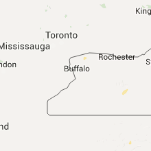
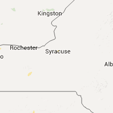
States Impacted
New York, Missouri, Iowa, Illinois, Georgia, Massachusetts, Florida, Alabama, Kansas, New Mexico, Oklahoma, Wisconsin, TexasNew York
| Local Time | Report Details |
|---|---|
| 3:00 PM EDT | Three trees down on elderberry lane - one down on wires blocking the road in oswego county NY, 15.2 miles N of Syracuse, NY |
| 3:03 PM EDT | Tree down blocking rte 3 in oswego county NY, 15.2 miles N of Syracuse, NY |
| 3:05 PM EDT | Tree down near gildner road in oswego county NY, 14.5 miles N of Syracuse, NY |
| 3:05 PM EDT | Several trees and power lines down in oswego county NY, 15.2 miles N of Syracuse, NY |
| 3:05 PM EDT | Power pole snapped in half on weber road in oswego county NY, 13.1 miles N of Syracuse, NY |
| 3:05 PM EDT | Power pole snapped off at base on kellar road in oswego county NY, 13.1 miles N of Syracuse, NY |
| 4:00 PM EDT | Three trees down on elderberry lane - one down on wires blocking the road in oswego county NY, 15.2 miles N of Syracuse, NY |
| 4:14 PM EDT | Several trees and wires down... multiple roads closed in cayuga county NY, 23.2 miles WNW of Syracuse, NY |
| 4:14 PM EDT | Multiple trees and wires down in cayuga county NY, 23.9 miles WNW of Syracuse, NY |
| 4:15 PM EDT | Trees on rec vehicles...other rec vehicles blown over at crosslake park in cayuga county NY, 18.5 miles WNW of Syracuse, NY |
| 4:38 PM EDT | Trees down in oswego county NY, 22 miles NNW of Syracuse, NY |
| 4:45 PM EDT | Estimated 12 trees down near berg/county line rds...one on home in wayne county NY, 63.2 miles WNW of Syracuse, NY |
| 5:02 PM EDT | Large tree down in oswego county NY, 31.7 miles NNW of Syracuse, NY |
| 5:10 PM EDT | Spotter reported multiple trees down on suny oswego campu in oswego county NY, 34 miles NW of Syracuse, NY |
| 6:15 PM EDT | Trees down in villag in lewis county NY, 38.5 miles SSE of Ogdensburg, NY |
| 8:00 PM EDT | Storm damage reported in st. lawrence county NY, 26.6 miles E of Ogdensburg, NY |
| 8:00 PM EDT | Trees down and roof damage to structure in st. lawrence county NY, 25.2 miles E of Ogdensburg, NY |
| 8:13 PM EDT | Trees and poles down in st. lawrence county NY, 29.1 miles E of Ogdensburg, NY |
| 8:30 PM EDT | Tree down on county route 49 in st. lawrence county NY, 36.3 miles ENE of Ogdensburg, NY |
Missouri
| Local Time | Report Details |
|---|---|
| 2:30 PM CDT | Large tree limb fell on a car causing extensive damag in franklin county MO, 51.7 miles W of Saint Louis, MO |
| 2:36 PM CDT | Soptter repoted 50 - 60 mph wind gust in franklin county MO, 52.7 miles W of Saint Louis, MO |
| 2:44 PM CDT | Small limbs down west of washington... mo in franklin county MO, 46.4 miles W of Saint Louis, MO |
| 2:44 PM CDT | Small winds down west of washington... mo in franklin county MO, 46.4 miles W of Saint Louis, MO |
| 3:05 PM CDT | Sporadic tree limbs down across town. largest branches about 6 inches in diameter down near highway n and in st. charles county MO, 37.8 miles WNW of Saint Louis, MO |
| 3:15 PM CDT | Large tree blown ove in st. charles county MO, 29.5 miles WNW of Saint Louis, MO |
| 4:10 PM CDT | Power poles and power lines down in the lafayette square are in st. louis city county MO, 2.3 miles WNW of Saint Louis, MO |
| 7:38 PM CDT | Multiple trees down in grain valley near valley speedwa in jackson county MO, 22.6 miles ESE of Kansas City, MO |
| 10:09 PM CDT | Shop destroyed along with damage to a house... truck and boa in lawrence county MO, 24 miles SW of Springfield, MO |
| 10:30 PM CDT | Large tree dow in christian county MO, 12.2 miles SSW of Springfield, MO |
| 10:50 PM CDT | Measured 45 gusting to 58 mp in christian county MO, 19.9 miles S of Springfield, MO |
| 10:55 PM CDT | A large tree that was damaged by thunderstorm wind gust monday evening...fell onto a house behind caseys in sparta when additional thunderstorms moved through this even in christian county MO, 18.6 miles SE of Springfield, MO |
| 11:00 PM CDT | Large tree reported down one block east of the square in the city of ozar in christian county MO, 13.8 miles SSE of Springfield, MO |
| 11:01 PM CDT | 1/2 mile west of nicholas road on highway 14... numerous 3 to 4 inch tree limbs dow in christian county MO, 12.1 miles SSW of Springfield, MO |
| 11:14 PM CDT | 6 to 8 inch diameter tree snapped along verna lane between gregg and nicholas roa in christian county MO, 11.7 miles S of Springfield, MO |
| 11:21 PM CDT | Trained spotter measured 72 mph gust at ground level. some downed trees also reporte in callaway county MO, 21.9 miles ESE of Columbia, MO |
Iowa
| Local Time | Report Details |
|---|---|
| 3:18 PM CDT | Several trees down in tow in jones county IA, 27.5 miles E of Cedar Rapids, IA |
| 3:50 PM CDT | 10 to 12 inch diameter tree branches dow in des moines county IA, 37.2 miles NE of Kahoka, MO |
Illinois
| Local Time | Report Details |
|---|---|
| 4:56 PM CDT | Quarter sized hail reported near Farmington, IL, 22.2 miles W of Peoria, IL |
| 5:13 PM CDT | Trained spotter reported tree damage near eden and route 8...relayed by emergency manager in peoria county IL, 14.1 miles WNW of Peoria, IL |
| 5:24 PM CDT | Estimated 50-60 mph wind gusts bending trees over on i-74 near exit 82...no damage noted at this time...swop report in peoria county IL, 10.1 miles WNW of Peoria, IL |
| 5:40 PM CDT | A mesonet station near mccluggage bridge and us-24/150 measured a 59 mph gus in tazewell county IL, 1.8 miles SSE of Peoria, IL |
| 5:53 PM CDT | 45 by 50 foot pole barn under construction was blown over in tazewell county IL, 20.1 miles SSE of Peoria, IL |
| 5:55 PM CDT | Power line blown down on oak street in hopedal in tazewell county IL, 20.7 miles SSE of Peoria, IL |
| 6:12 PM CDT | 4 to 6 inch diameter tree branches blown down in congerville in woodford county IL, 20.5 miles ESE of Peoria, IL |
| 7:00 PM CDT | About 7 trees damaged in the sandrock subdivision. trees and large limbs down...one vehicle was damaged by a downed tre in st. clair county IL, 18.8 miles SE of Saint Louis, MO |
| 7:32 PM CDT | At gardner fire departmen in grundy county IL, 59.4 miles SW of Chicago, IL |
| 7:45 PM CDT | 5-inch tree limbs were blown down in coles county IL, 15.1 miles ENE of Mattoon, IL |
Georgia
| Local Time | Report Details |
|---|---|
| 6:02 PM EDT | Quarter sized hail reported near Dacula, GA, 34.6 miles NE of Atlanta, GA |
| 9:05 PM EDT | Warning point reported large tree down at the intersection of lakeview road and bernard smith roa in bulloch county GA, 52.6 miles NW of Savannah, GA |
| 9:05 PM EDT | Public reported 10-15 large pine trees down on middle ground road near mallard pond roa in bulloch county GA, 53.5 miles NW of Savannah, GA |
| 9:15 PM EDT | Public reported two trees down at the 500 block of south well lan in bulloch county GA, 42.4 miles WNW of Savannah, GA |
| 9:23 PM EDT | Spotter reported two trees down and shingles torn off roof on burkhalter road near five chop roa in bulloch county GA, 42.1 miles NW of Savannah, GA |
Massachusetts
| Local Time | Report Details |
|---|---|
| 6:18 PM EDT | Quarter sized hail reported near Boylston, MA, 41.8 miles NNW of Providence, RI, amateur radio |
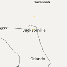
Florida
| Local Time | Report Details |
|---|---|
| 6:20 PM EDT | Quarter sized hail reported near Jacksonville, FL, 11.2 miles NNW of Jacksonville, FL, quarter size hail at the nws office. |
| 6:50 PM EDT | Tree down across ferry road in palatk in putnam county FL, 47.1 miles S of Jacksonville, FL |
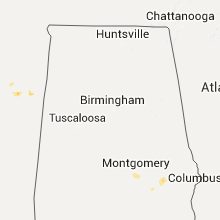
Alabama
| Local Time | Report Details |
|---|---|
| 5:30 PM CDT | Tree limbs downing power lines across various parts of town. winds estimated 40-50 mp in montgomery county AL, 49.9 miles WSW of Auburn, AL |
Kansas
| Local Time | Report Details |
|---|---|
| 5:33 PM CDT | Quarter sized hail reported near Lawrence, KS, 46.1 miles WSW of Kansas City, MO, small tree limbs down as well |
| 5:46 PM CDT | Quarter sized hail reported near Lawrence, KS, 46.6 miles WSW of Kansas City, MO |
| 7:13 PM CDT | Storm damage reported in labette county KS, 24.6 miles S of Chanute, KS |
| 7:15 PM CDT | Trees and power poles down. estimated 65 mph win in montgomery county KS, 28.9 miles S of Chanute, KS |
| 7:25 PM CDT | Two foot diameter trees down with some structures damage in montgomery county KS, 28.7 miles S of Chanute, KS |
| 7:41 PM CDT | Large tree over gove roa in labette county KS, 32 miles S of Chanute, KS |
| 7:43 PM CDT | Winds estimated at 60+ mp in labette county KS, 26.9 miles SSE of Chanute, KS |
| 7:43 PM CDT | Wind speed estimated by emergency manager in cherokee county KS, 45.4 miles SE of Chanute, KS |
| 7:49 PM CDT | Quarter sized hail reported near Cherryvale, KS, 28.9 miles S of Chanute, KS |
| 8:02 PM CDT | Power lines dow in labette county KS, 40 miles SSE of Chanute, KS |
| 8:22 PM CDT | Estimated wind gust at koam-tv studios in cherokee county KS, 54.4 miles SE of Chanute, KS |
New Mexico
| Local Time | Report Details |
|---|---|
| 5:09 PM MDT | Golf Ball sized hail reported near Des Moines, NM, 99.9 miles ENE of Taos, NM, dents to vehicle from golfball sized hail. |
| 5:10 PM MDT | Golf Ball sized hail reported near Folsom, NM, 92.7 miles ENE of Taos, NM |
| 5:15 PM MDT | Golf Ball sized hail reported near Des Moines, NM, 91 miles ENE of Taos, NM |
| 5:15 PM MDT | Tennis Ball sized hail reported near Des Moines, NM, 91 miles ENE of Taos, NM |
| 5:58 PM MDT | Storm damage reported in union county NM, 87.8 miles N of Tucumcari, NM |
| 7:24 PM MDT | Baseball sized hail reported near Amistad, NM, 60.3 miles NNE of Tucumcari, NM |
| 7:35 PM MDT | Golf Ball sized hail reported near Amistad, NM, 48.3 miles NNE of Tucumcari, NM |
| 7:55 PM MDT | Quarter sized hail reported near Amistad, NM, 55.1 miles NE of Tucumcari, NM |
| 8:30 PM MDT | Quarter sized hail reported near Nara Visa, NM, 46.1 miles NE of Tucumcari, NM |
Oklahoma
| Local Time | Report Details |
|---|---|
| 6:20 PM CDT | Quarter sized hail reported near Ponca City, OK, 66.3 miles SSE of Wichita, KS |
| 7:30 PM CDT | Storm damage reported in caddo county OK, 54.1 miles W of Oklahoma City, OK |
| 7:35 PM CDT | Storm damage reported in caddo county OK, 54.1 miles W of Oklahoma City, OK |
| 12:14 AM CDT | Quarter sized hail reported near Shattuck, OK, 39.5 miles WSW of Woodward, OK, hail up to quarter size was falling near the oklahoma state line. |
Wisconsin
| Local Time | Report Details |
|---|---|
| 9:15 PM CDT | Metal roofing and debri near intersection of hwy 120 and hwy 12. doors ripped off aurora healthcare building. trees dow in walworth county WI, 58.9 miles SE of Madison, WI |
| 9:44 PM CDT | Trees down greater than 12 inches in diameter in walworth county WI, 59 miles ESE of Madison, WI |
Texas
| Local Time | Report Details |
|---|---|
| 10:50 PM CDT | Quarter sized hail reported near Perryton, TX, 78.1 miles W of Woodward, OK, quarter size hail fell until 1055 pm. |
| 10:52 PM CDT | Quarter sized hail reported near Canadian, TX, 65.5 miles WSW of Woodward, OK |
| 11:59 PM CDT | Golf Ball sized hail reported near Lefors, TX, 60.6 miles ENE of Amarillo, TX |
| 2:04 AM CDT | Storm damage reported in randall county TX, 16.4 miles SSW of Amarillo, TX |
| 2:05 AM CDT | Power poles down just east of canyon.. trees blown down just north of canyon. an rv trailer was flipped over just north of canyon as wel in randall county TX, 16.1 miles SSW of Amarillo, TX |
| 2:10 AM CDT | An empty tractor trailer was blown up on top of a 10 foot stack of equipment and was resting on its side. power is out and there is quite a bit of fence damage. also. in randall county TX, 12.5 miles SSW of Amarillo, TX |
| 2:12 AM CDT | Storm damage reported in randall county TX, 20.5 miles SW of Amarillo, TX |
| 2:15 AM CDT | Storm damage reported in randall county TX, 20.5 miles SW of Amarillo, TX |
| 2:16 AM CDT | Storm damage reported in randall county TX, 10 miles SSE of Amarillo, TX |
| 2:35 AM CDT | Measured by the west texas mesonet in swisher county TX, 46.3 miles S of Amarillo, TX |
Connect with Interactive Hail Maps