

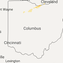
Hail Map for Monday, August 21, 2017

Number of Impacted Households on 8/21/2017
0
Impacted by 1" or Larger Hail
0
Impacted by 1.75" or Larger Hail
0
Impacted by 2.5" or Larger Hail
Square Miles of Populated Area Impacted on 8/21/2017
0
Impacted by 1" or Larger Hail
0
Impacted by 1.75" or Larger Hail
0
Impacted by 2.5" or Larger Hail


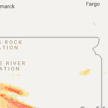


Cities Most Affected by Hail Storms of 8/21/2017
| Hail Size | Demographics of Zip Codes Affected | ||||||
|---|---|---|---|---|---|---|---|
| City | Count | Average | Largest | Pop Density | House Value | Income | Age |
| Olivet, SD | 1 | 2.00 | 2.00 | 2 | $27k | $30.5k | 38.0 |
| Fort Pierre, SD | 1 | 1.75 | 1.75 | 2 | $85k | $41.6k | 41.8 |
| Menno, SD | 1 | 1.75 | 1.75 | 5 | $31k | $29.3k | 53.7 |
| Stickney, SD | 1 | 1.75 | 1.75 | 3 | $28k | $28.9k | 47.9 |
| Watertown, SD | 1 | 1.75 | 1.75 | 78 | $86k | $36.2k | 37.5 |
Hail and Wind Damage Spotted on 8/21/2017
Filter by Report Type:Hail ReportsWind Reports
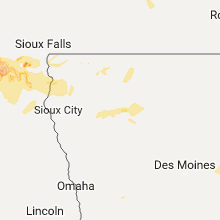
States Impacted
South Dakota, Missouri, Iowa, Pennsylvania, Illinois, Ohio, Maryland, Virginia, New York, Nebraska, Texas, KansasSouth Dakota
| Local Time | Report Details |
|---|---|
| 7:38 AM CDT | Golf Ball sized hail reported near Watertown, SD, 71.3 miles W of Montevideo, MN, mostly pea hail but some reached the size of a golfball. |
| 8:58 AM CDT | Golf Ball sized hail reported near Fort Pierre, SD, 1.6 miles WSW of Pierre, SD |
| 9:01 AM CDT | 60-70 mph winds. radar estimated tim in jones county SD, 22 miles SSW of Pierre, SD |
| 9:20 AM CDT | Ping Pong Ball sized hail reported near Fort Pierre, SD, 19.4 miles SE of Pierre, SD |
| 9:30 AM CDT | Quarter sized hail reported near Fort Pierre, SD, 15 miles SE of Pierre, SD, pea to quarter size hail. |
| 9:41 AM CDT | Storm damage reported in lyman county SD, 30.4 miles S of Pierre, SD |
| 10:20 AM CDT | Many good sized limbs downe in lyman county SD, 51.6 miles SE of Pierre, SD |
| 10:20 AM CDT | Quarter sized hail reported near Kennebec, SD, 51.6 miles SE of Pierre, SD |
| 10:45 AM CDT | Quarter sized hail reported near Reliance, SD, 61.1 miles SE of Pierre, SD |
| 11:00 AM CDT | Ping Pong Ball sized hail reported near Chamberlain, SD, 71.4 miles SE of Pierre, SD |
| 12:05 PM CDT | Golf Ball sized hail reported near Stickney, SD, 72 miles N of Oneill, NE |
| 12:10 PM CDT | Storm damage reported in douglas county SD, 68.3 miles N of Oneill, NE |
| 12:53 PM CDT | Quarter sized hail reported near Parker, SD, 22.9 miles WSW of Sioux Falls, SD |
| 12:55 PM CDT | Hen Egg sized hail reported near Olivet, SD, 51.7 miles WSW of Sioux Falls, SD |
| 1:06 PM CDT | Golf Ball sized hail reported near Menno, SD, 46.3 miles WSW of Sioux Falls, SD |
| 1:36 PM CDT | Quarter sized hail reported near Yankton, SD, 56.4 miles SW of Sioux Falls, SD, along with very heavy rain. |
Missouri
| Local Time | Report Details |
|---|---|
| 9:31 AM CDT | A couple of branches fell over crossing drive. they were about 6-8 inches in diamete in jackson county MO, 17.1 miles SE of Kansas City, MO |
| 3:35 PM CDT | Downed tree limbs less than 2 inches in diamete in clay county MO, 10.9 miles N of Kansas City, MO |
| 4:21 PM CDT | Quarter sized hail reported near Riverside, MO, 5.5 miles NNW of Kansas City, MO |
| 6:15 PM CDT | Large tree down... power lines down and roof torn off a bar in pettis county MO, 43 miles W of Columbia, MO |
| 6:40 PM CDT | Storm damage reported in cooper county MO, 28.4 miles WSW of Columbia, MO |
Iowa
| Local Time | Report Details |
|---|---|
| 11:48 AM CDT | Quarter sized hail reported near Rock Rapids, IA, 29.3 miles ESE of Sioux Falls, SD |
| 2:45 PM CDT | Tree damage on the northwest side of tow in plymouth county IA, 50.3 miles WNW of Storm Lake, IA |
| 7:05 PM CDT | Relayed em report of estimated 60-65 mph winds at brooklyn exit on i-8 in poweshiek county IA, 43.9 miles WSW of Cedar Rapids, IA |
Pennsylvania
| Local Time | Report Details |
|---|---|
| 1:00 PM EDT | Two trees down on cumberland avenue and south 4th stree in clearfield county PA, 33.8 miles WNW of State College, PA |
Illinois
| Local Time | Report Details |
|---|---|
| 12:17 PM CDT | Storm damage reported in coles county IL, 5.1 miles E of Mattoon, IL |
| 12:17 PM CDT | Asos wind gust at 1217 in coles county IL, 0.3 miles ESE of Mattoon, IL |
| 12:24 PM CDT | Asos thunderstorm wind gust at 122 in coles county IL, 0.3 miles ESE of Mattoon, IL |
| 12:46 PM CDT | Reported by coles eo in coles county IL, 10.9 miles ESE of Mattoon, IL |
| 12:46 PM CDT | Reported by coles eo in coles county IL, 10.9 miles ESE of Mattoon, IL |
Ohio
| Local Time | Report Details |
|---|---|
| 3:39 PM EDT | Quarter sized hail reported near Green Springs, OH, 72.6 miles WSW of Cleveland, OH |
| 4:26 PM EDT | Quarter sized hail reported near Huron, OH, 45.7 miles W of Cleveland, OH, half inch to quarter size hail. |
Maryland
| Local Time | Report Details |
|---|---|
| 4:17 PM EDT | Quarter sized hail reported near Dundalk, MD, 7.6 miles E of Baltimore, MD |
| 4:56 PM EDT | Many trees down between charles street and budds creek road in charles county MD, 59.7 miles SSW of Baltimore, MD |
| 5:04 PM EDT | A couple trees were dow in st. marys county MD, 64.1 miles SSW of Baltimore, MD |
| 7:59 PM EDT | Multiple trees and poles down from smithsburg to cascade md...some trees on homes in washington county MD, 57.9 miles WNW of Baltimore, MD |
| 7:59 PM EDT | Medium to large tree branches down in washington county MD, 58.4 miles WNW of Baltimore, MD |
| 7:59 PM EDT | Barn/pole barn collapsed in storm in washington county MD, 57.8 miles WNW of Baltimore, MD |
| 8:49 PM EDT | Tree down at fish hatchery road and bethel road in frederick county MD, 47.2 miles WNW of Baltimore, MD |
Virginia
| Local Time | Report Details |
|---|---|
| 5:02 PM EDT | Trees down on marsh road and harpers run road in fauquier county VA, 70.2 miles N of Richmond, VA |
| 5:06 PM EDT | Trees down at marsh road and razor hill road in fauquier county VA, 69.5 miles N of Richmond, VA |
| 5:52 PM EDT | Thunderstorm outflow winds along with water loading brought down two trees within the community of forest... virgini in bedford county VA, 37 miles E of Roanoke, VA |
| 6:17 PM EDT | Multiple tress down and trees on wires by route 3 in culpeper county VA, 63.2 miles N of Richmond, VA |
| 6:35 PM EDT | Trees down at raccoon ford road and rebel ridge lane near the rive in orange county VA, 61.3 miles NNW of Richmond, VA |
| 7:45 PM EDT | Storm damage reported in anz536 county VA, 65.2 miles NNE of Richmond, VA |
New York
| Local Time | Report Details |
|---|---|
| 5:10 PM EDT | A few trees down between spencer and cando in tioga county NY, 59.1 miles SSW of Syracuse, NY |
Nebraska
| Local Time | Report Details |
|---|---|
| 5:07 PM CDT | Quarter sized hail reported near Verdigre, NE, 34.5 miles ENE of Oneill, NE |
Texas
| Local Time | Report Details |
|---|---|
| 5:15 PM CDT | Storm damage reported in lubbock county TX, 5.7 miles NNE of Lubbock, TX |
| 5:19 PM CDT | Sustained 49 mph. measured by west texas mesone in hale county TX, 40.5 miles NNE of Lubbock, TX |
| 7:30 PM CDT | Measured by west texas mesone in motley county TX, 24.8 miles WSW of Childress, TX |
Kansas
| Local Time | Report Details |
|---|---|
| 8:40 PM CDT | Storm damage reported in jefferson county KS, 48.4 miles W of Kansas City, MO |
| 8:40 PM CDT | 2 inh tree limb dow in jefferson county KS, 50 miles W of Kansas City, MO |
| 8:45 PM CDT | Measured near central and zo in sedgwick county KS, 2.4 miles W of Wichita, KS |
| 9:04 PM CDT | Social media report of branches down (est. 1-2 inches in diameter) at 42nd and adams in topeka. radar estimated tim in shawnee county KS, 49.7 miles ESE of Manhattan, KS |
| 9:21 PM CDT | 6 inch limb dow in lyon county KS, 56.3 miles SSE of Manhattan, KS |
| 9:21 PM CDT | Reports of several limbs down in the neighborhood around 2 inche in lyon county KS, 57.7 miles SSE of Manhattan, KS |
| 9:21 PM CDT | Relayed via photos on social media. 10 inch tree branch split from the main trunk. radar estimated tim in lyon county KS, 57.5 miles SSE of Manhattan, KS |
| 9:39 PM CDT | Em relayed reports of strong winds of 60 mph at peterson and kasold av in douglas county KS, 37.6 miles WSW of Kansas City, MO |
| 10:00 PM CDT | Storm damage reported in johnson county KS, 22.5 miles WSW of Kansas City, MO |
Connect with Interactive Hail Maps