

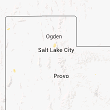
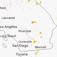
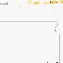
Hail Map for Saturday, August 24, 2013

Number of Impacted Households on 8/24/2013
0
Impacted by 1" or Larger Hail
0
Impacted by 1.75" or Larger Hail
0
Impacted by 2.5" or Larger Hail
Square Miles of Populated Area Impacted on 8/24/2013
0
Impacted by 1" or Larger Hail
0
Impacted by 1.75" or Larger Hail
0
Impacted by 2.5" or Larger Hail


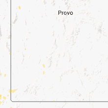


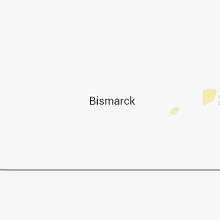

Cities Most Affected by Hail Storms of 8/24/2013
| Hail Size | Demographics of Zip Codes Affected | ||||||
|---|---|---|---|---|---|---|---|
| City | Count | Average | Largest | Pop Density | House Value | Income | Age |
| Roseau, MN | 1 | 2.00 | 2.00 | 12 | $81k | $41.1k | 41.1 |
Hail and Wind Damage Spotted on 8/24/2013
Filter by Report Type:Hail ReportsWind Reports
Nevada
| Local Time | Report Details |
|---|---|
| 12:30 PM PDT | Quarter sized hail reported near Jean, NV, 37 miles SW of Las Vegas, NV, report via facebook |
Utah
| Local Time | Report Details |
|---|---|
| 3:10 PM MDT | West salt flats sensor dpg26 in tooele county UT, 95.5 miles NE of Ely, NV |
| 4:25 PM MDT | Diddle knoll sensor dpg27 in tooele county UT, 67 miles W of Salt Lake City, UT |
| 4:57 PM MDT | Quarter sized hail reported near Salt Lake City, UT, 3.5 miles S of Salt Lake City, UT |
| 5:21 PM MDT | Quarter sized hail reported near Layton, UT, 22.4 miles N of Salt Lake City, UT, many reports of nickel to quarter sized hail |
| 5:21 PM MDT | Trees down on fairfield road in davis county UT, 22.4 miles N of Salt Lake City, UT |
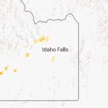
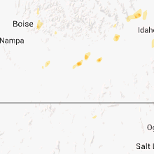
Idaho
| Local Time | Report Details |
|---|---|
| 3:20 PM MDT | Quarter sized hail reported near Jerome, ID, 17 miles N of Twin Falls, ID, relayed through media. |
| 3:44 PM MDT | Quarter sized hail reported near Glenns Ferry, ID, 50.2 miles WNW of Twin Falls, ID, strong winds. report relayed by media. |
| 3:51 PM MDT | Quarter sized hail reported near Shoshone, ID, 26.7 miles N of Twin Falls, ID |
| 3:51 PM MDT | Quarter sized hail reported near Blackfoot, ID, 26 miles SW of Idaho Falls, ID, up to 1 inch hail reported |
| 5:43 PM MDT | Trail gulch raws at 5700 fee in twin falls county ID, 18.6 miles SSE of Twin Falls, ID |
California
| Local Time | Report Details |
|---|---|
| 2:30 PM PDT | Delayed report...storm continued until 330 pm. multiple trees and power lines blown down in riverside county CA, 56.9 miles ESE of Yucca Valley, CA |
| 3:40 PM PDT | Delayed report...gusty winds for more than an hour in holtvill in imperial county CA, 44.2 miles WNW of Yuma, AZ |
Minnesota
| Local Time | Report Details |
|---|---|
| 7:15 PM CDT | Quarter sized hail reported near Warroad, MN, 20.6 miles E of Roseau, MN |
| 7:37 PM CDT | Report of multiple 20-30 ft trees down. time estimated from rada in roseau county MN, 3.1 miles E of Roseau, MN |
| 7:40 PM CDT | Hen Egg sized hail reported near Roseau, MN, 9.4 miles ESE of Roseau, MN, public facebook report relayed via media partner. |
| 3:55 AM CDT | Grain bin under construction was blown over. large hail to near golfball size also reported via kvly facebook pag in clay county MN, 7.9 miles N of Fargo, ND |
North Dakota
| Local Time | Report Details |
|---|---|
| 3:40 AM CDT | Hail and wind caused some crop damage. hail size unknow in barnes county ND, 54.3 miles W of Fargo, ND |
| 3:53 AM CDT | Storm damage reported in cass county ND, 1.8 miles W of Fargo, ND |
Connect with Interactive Hail Maps