

Hail Map for Friday, August 27, 2021

Number of Impacted Households on 8/27/2021
0
Impacted by 1" or Larger Hail
0
Impacted by 1.75" or Larger Hail
0
Impacted by 2.5" or Larger Hail
Square Miles of Populated Area Impacted on 8/27/2021
0
Impacted by 1" or Larger Hail
0
Impacted by 1.75" or Larger Hail
0
Impacted by 2.5" or Larger Hail
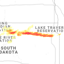


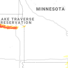


Cities Most Affected by Hail Storms of 8/27/2021
| Hail Size | Demographics of Zip Codes Affected | ||||||
|---|---|---|---|---|---|---|---|
| City | Count | Average | Largest | Pop Density | House Value | Income | Age |
| Valley, NE | 2 | 2.25 | 2.50 | 69 | $92k | $42.2k | 44.4 |
| Ipswich, SD | 1 | 2.50 | 2.50 | 3 | $47k | $32.0k | 45.6 |
| Selby, SD | 1 | 2.50 | 2.50 | 1 | $33k | $31.5k | 51.7 |
| Webster, SD | 1 | 1.75 | 1.75 | 7 | $41k | $33.4k | 47.3 |
| Warner, SD | 1 | 1.75 | 1.75 | 4 | $67k | $47.4k | 38.0 |
Hail and Wind Damage Spotted on 8/27/2021
Filter by Report Type:Hail ReportsWind Reports
States Impacted
Wisconsin, Pennsylvania, Michigan, New Jersey, Florida, Virginia, Maryland, Kentucky, New York, Indiana, Massachusetts, Nebraska, Iowa, Ohio, Montana, Alabama, North Dakota, Arizona, South Dakota, DelawareWisconsin
| Local Time | Report Details |
|---|---|
| 9:35 AM CDT | Tree snapped off at bas in dane county WI, 13.6 miles WNW of Madison, WI |
| 10:40 AM CDT | Combination of lightning strikes and wind gusts to 40 to 50 mph with resultant tree damage resulted in several power outages in the fox lake are in dodge county WI, 41.9 miles NE of Madison, WI |
| 6:39 PM CDT | 51 knots measured at the wisconsin rapids airport. law enforcement reported a couple of trees down on the north side of tow in wood county WI, 81.1 miles ENE of La Crosse, WI |
| 9:50 PM CDT | Report of a downed tre in grant county WI, 57.6 miles S of La Crosse, WI |
| 10:01 PM CDT | 1 downed powerlin in grant county WI, 61.9 miles SSE of La Crosse, WI |
| 11:40 PM CDT | Several reports of trees and powerlines down along highway 56 around libert in vernon county WI, 34.7 miles SE of La Crosse, WI |
Pennsylvania
| Local Time | Report Details |
|---|---|
| 12:33 PM EDT | Downed tree limbs and wires near country place drive. time estimated from radar and outage report in monroe county PA, 20.2 miles SE of Scranton, PA |
| 1:36 PM EDT | Downed wires near maple drive. time estimated from rada in monroe county PA, 19 miles SSE of Scranton, PA |
| 1:59 PM EDT | Downed wires near state route 115. time estimated from rada in monroe county PA, 27.7 miles SSE of Scranton, PA |
| 2:04 PM EDT | Multiple trees down on osborne road. time estimated from rada in chester county PA, 68.1 miles NE of Baltimore, MD |
| 2:05 PM EDT | Several trees reported down around caln township. time estimated from rada in chester county PA, 67.2 miles NE of Baltimore, MD |
| 2:10 PM EDT | Several large branches down blocking traffic. time estimated from rada in chester county PA, 67.2 miles NE of Baltimore, MD |
| 2:13 PM EDT | Multiple trees down on hurley road. time estimated from rada in chester county PA, 66.1 miles NE of Baltimore, MD |
| 2:18 PM EDT | Several trees down in the area of pratts dam road. time estimated from rada in chester county PA, 64.6 miles NE of Baltimore, MD |
| 2:20 PM EDT | Tree and pole down in the 900 block of horseshoe pike. time estimated from rada in chester county PA, 68.4 miles NE of Baltimore, MD |
| 2:26 PM EDT | Downed tree in wires on molasses valley road. time estimated from rada in monroe county PA, 37.1 miles SSE of Scranton, PA |
| 2:30 PM EDT | Multiple trees down at route 30 bypass and moore road. time estimate in chester county PA, 64.9 miles NE of Baltimore, MD |
| 2:30 PM EDT | Trees down along route 84 between 30 bypass and 30 business just north of coatesville. time estimated from rada in chester county PA, 63.7 miles NE of Baltimore, MD |
| 2:34 PM EDT | Downed tree limbs and wires near blackberry lane. time estimated from rada in monroe county PA, 38.2 miles SSE of Scranton, PA |
| 2:42 PM EDT | Downed tree on rainbow road near west lincoln highway. time estimated from rada in chester county PA, 62.5 miles NE of Baltimore, MD |
| 5:15 PM EDT | Several trees down in the area. several outbuildings at a farm collapse in dauphin county PA, 68.8 miles ESE of State College, PA |
| 5:15 PM EDT | Part of a roof blown off of a bar in dauphin county PA, 69.3 miles ESE of State College, PA |
| 5:36 PM EDT | Tree on wire in lancaster county PA, 49.8 miles NNE of Baltimore, MD |
| 5:40 PM EDT | Trees on wire in lancaster county PA, 58.7 miles NNE of Baltimore, MD |
| 5:40 PM EDT | Tree on wire in lancaster county PA, 54.5 miles NNE of Baltimore, MD |
| 5:58 PM EDT | Strong thunderstorm winds knocked down tree onto roadwa in bradford county PA, 57.5 miles WNW of Scranton, PA |
| 6:31 PM EDT | Downed tree limbs and wires west of reider road. time estimated from rada in berks county PA, 75.3 miles SSW of Scranton, PA |
| 6:31 PM EDT | Downed trees and wires near steely road and church road. time estimated from rada in berks county PA, 76.9 miles SSW of Scranton, PA |
| 6:36 PM EDT | Downed trees and wires near station road. time estimated from rada in berks county PA, 73.1 miles SSW of Scranton, PA |
| 6:56 PM EDT | Downed trees and wires near plum road. time estimated from rada in berks county PA, 70 miles SSW of Scranton, PA |
| 7:00 PM EDT | Multiple reports of trees down between penn twp and centerport. time estimated from rada in berks county PA, 68.2 miles SSW of Scranton, PA |
| 7:09 PM EDT | A few reports of downed trees and wires in centre twp. time estimated from rada in berks county PA, 68.1 miles SSW of Scranton, PA |
Michigan
| Local Time | Report Details |
|---|---|
| 1:30 PM EDT | Numerous trees and wires down. time estimated by rada in wayne county MI, 58.5 miles SE of Flint, MI |
| 7:50 PM EDT | Numerous trees and limbs down in baldwin area...via lake county dispatch. time estimated from radar and consumers energy outage ma in lake county MI, 60.5 miles S of Traverse City, MI |
| 7:53 PM EDT | Tree down on wires near u.s. forest service ranger station in baldwin. pea-sized hail also observed. relayed via wfo ap in lake county MI, 60.5 miles S of Traverse City, MI |
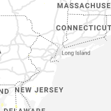
New Jersey
| Local Time | Report Details |
|---|---|
| 2:39 PM EDT | Downed trees and wires near mount hermon road. time estimated from rada in warren county NJ, 49.9 miles SE of Scranton, PA |
| 2:50 PM EDT | Small area of limbs down just west of great meadows along us 46. time estimated from rada in warren county NJ, 50.3 miles WNW of Brooklyn, NY |
| 2:55 PM EDT | Downed trees and wires near mountain lake road. time estimated from rada in warren county NJ, 51.8 miles SE of Scranton, PA |
| 2:58 PM EDT | Downed trees and wires near hudson lane. time estimated from rada in warren county NJ, 50.1 miles WNW of Brooklyn, NY |
| 2:59 PM EDT | An mping report of downed tree limb in warren county NJ, 50.1 miles WNW of Brooklyn, NY |
| 3:00 PM EDT | Downed wires near pinewald keswick road. time estimated from rada in ocean county NJ, 54.8 miles SSW of Brooklyn, NY |
| 3:02 PM EDT | Spotter reported several downed tree limbs and being blown over while attempting to close barn doors. time estimated from rada in warren county NJ, 50.6 miles SE of Scranton, PA |
| 3:10 PM EDT | Trees down on powerlines. time estimated from rada in ocean county NJ, 42.4 miles SSW of Brooklyn, NY |
| 3:21 PM EDT | Downed wires near germania station road. time estimated from rada in ocean county NJ, 51.6 miles SSW of Brooklyn, NY |
| 3:27 PM EDT | Downed pole and wires on u.s. highway 9 near 8th street. time estimated from rada in ocean county NJ, 42.6 miles SSW of Brooklyn, NY |
| 3:37 PM EDT | Downed wires near monroe avenue. time estimated from rada in ocean county NJ, 55.8 miles SSW of Brooklyn, NY |
| 4:55 PM EDT | Strong winds snapped an old tree trunk. time estimated from rada in gloucester county NJ, 87.5 miles SW of Brooklyn, NY |
| 5:05 PM EDT | Corrects previous tstm wnd dmg report from monroe twp. strong winds snapped an old tree trunk. time estimated from rada in gloucester county NJ, 87.5 miles SW of Brooklyn, NY |
| 5:10 PM EDT | Corrects previous tstm wnd dmg report from monroe twp. corrects previous tstm wnd dmg report from monroe twp. strong winds snapped an old tree trunk. time estimated fro in gloucester county NJ, 87.5 miles SW of Brooklyn, NY |
Florida
| Local Time | Report Details |
|---|---|
| 2:48 PM EDT | Mesonet station fw1789 clearwater beac in pinellas county FL, 37.4 miles NNW of Bradenton, FL |
| 6:00 PM EDT | Report of trees down with power outages near foley rd and hwy1 in taylor county FL, 50.1 miles ESE of Tallahassee, FL |
| 6:42 PM EDT | Half of a large live oak tree fell across mossy creek l in leon county FL, 4.5 miles SE of Tallahassee, FL |
| 6:48 PM EDT | Duke energy reported a power outage due to fallen trees on equipmen in leon county FL, 18.4 miles ENE of Tallahassee, FL |
| 7:00 PM EDT | Multiple trees and power lines reported down across leon count in leon county FL, 2.8 miles N of Tallahassee, FL |
| 7:08 PM EDT | Report of a tree on a home near otter cree in leon county FL, 11.9 miles N of Tallahassee, FL |
| 7:25 PM EDT | Bald point mesonet reported a gust of 47 mp in gmz730 county FL, 33.9 miles S of Tallahassee, FL |
| 1:23 AM EDT | A southeast wind gust of 56 kts... or 64 mph... was recorded by the key west international airport asos at 123 am edt. this site also recorded a 1-minute sustained wind in lower keys in monr county FL, 2.8 miles ENE of Key West, FL |
| 1:41 AM EDT | A southeast wind gust of 52 kts... or 60 mph... was recorded by the weatherflow mesonet site at smith shoal light at 141 am ed in gmz033 county FL, 13.5 miles NW of Key West, FL |
Virginia
| Local Time | Report Details |
|---|---|
| 3:12 PM EDT | Tree down on route 7380 near black-eyed susan lan in fairfax county VA, 43.5 miles WSW of Baltimore, MD |
| 3:26 PM EDT | Tree down on the northbound ramp of george washington parkway to i-49 in fairfax county VA, 38.2 miles SW of Baltimore, MD |
| 4:15 PM EDT | Tree down on a power line at the intersection of virginia ridge road and hardy roa in bedford county VA, 7 miles ESE of Roanoke, VA |
| 4:20 PM EDT | Trees down near the intersection of edwardsville road and hardy roa in franklin county VA, 8.8 miles ESE of Roanoke, VA |
| 4:20 PM EDT | Corrects previous tstm wnd dmg report from 4 ssw stewartsville. trees down near the intersection of whispering heights drive and coopers cove roa in franklin county VA, 7.5 miles ESE of Roanoke, VA |
| 4:20 PM EDT | Corrects previous tstm wnd dmg report from 4 ssw stewartsville. trees down near the intersection of whispering heights drive and coopers cove roa in franklin county VA, 7.5 miles ESE of Roanoke, VA |
| 4:58 PM EDT | Tree and power pole down on gilmore driv in fairfax county VA, 50.9 miles SW of Baltimore, MD |
| 4:58 PM EDT | Tree and power pole down on gilmore driv in fairfax county VA, 51.5 miles SW of Baltimore, MD |
| 5:26 PM EDT | Tree down on route 4301 near cardiff stree in fairfax county VA, 54 miles SW of Baltimore, MD |
Maryland
| Local Time | Report Details |
|---|---|
| 3:16 PM EDT | Storm damage reported in montgomery county MD, 35.2 miles WSW of Baltimore, MD |
| 3:17 PM EDT | Tree down on gainsborough road near democracy boulevar in montgomery county MD, 35.4 miles WSW of Baltimore, MD |
| 3:21 PM EDT | Multiple trees down in the willerburn acres neighborhoo in montgomery county MD, 33.9 miles WSW of Baltimore, MD |
| 3:21 PM EDT | Tree down on innerloop ramp to westbound clara barton parkwa in montgomery county MD, 37.8 miles SW of Baltimore, MD |
| 3:26 PM EDT | Powerline wires down on the 6000 block of tilden lane in montgomery county MD, 32.4 miles WSW of Baltimore, MD |
| 3:35 PM EDT | Tree down on the 2000 block of clark place in montgomery county MD, 30.1 miles SW of Baltimore, MD |
| 3:35 PM EDT | Tree and wires down on jefferson pike near wye creek driv in frederick county MD, 46.2 miles W of Baltimore, MD |
| 3:40 PM EDT | Powerline wires down on georgia avenue between columbia blvd and corwin drive in montgomery county MD, 30.2 miles SW of Baltimore, MD |
| 3:45 PM EDT | Tree down and powerlines down on the 100 block of eastmoor drive in montgomery county MD, 28 miles SW of Baltimore, MD |
| 3:54 PM EDT | Tree down and powerline wires down on the 1000 block of mimosa lane in montgomery county MD, 25.1 miles SW of Baltimore, MD |
| 3:54 PM EDT | Multiple trees down on elm street in takoma par in montgomery county MD, 30.5 miles SW of Baltimore, MD |
| 4:17 PM EDT | Tree down on us-15 in frederick county MD, 46.9 miles NW of Baltimore, MD |
| 4:40 PM EDT | Trees and wires down in millersvill in anne arundel county MD, 16.1 miles S of Baltimore, MD |
| 4:45 PM EDT | Trees and wires down in herald harbo in anne arundel county MD, 16.7 miles S of Baltimore, MD |
| 5:03 PM EDT | Tree down in belvedere par in anne arundel county MD, 17 miles SSE of Baltimore, MD |
| 5:25 PM EDT | Tree down on westbound us-50 and us-301 in anne arundel county MD, 21.5 miles SSE of Baltimore, MD |
| 5:50 PM EDT | Tree down on falls road near monkton roa in baltimore county MD, 20 miles N of Baltimore, MD |
| 6:11 PM EDT | Tree down on fallston road near fox meadow cour in harford county MD, 20.8 miles NNE of Baltimore, MD |
| 6:17 PM EDT | Powerline wires down on the 12000 block of stoney batter road in baltimore county MD, 14.8 miles NE of Baltimore, MD |
| 7:23 PM EDT | Tree feel into a residence on cloverfields dr. no injurie in queen anne's county MD, 25.7 miles SE of Baltimore, MD |
| 7:31 PM EDT | Downed tree limbs and wires near grace street. time estimated from rada in talbot county MD, 40.7 miles SSE of Baltimore, MD |
| 7:33 PM EDT | Downed wires near perry cabin lane. time estimated from rada in talbot county MD, 40.4 miles SSE of Baltimore, MD |
Kentucky
| Local Time | Report Details |
|---|---|
| 4:43 PM EDT | Tree knocked down in grant county KY, 41.9 miles S of Cincinnati, OH |
| 5:23 PM EDT | Tree down across roadwa in pendleton county KY, 23 miles SSE of Cincinnati, OH |
New York
| Local Time | Report Details |
|---|---|
| 4:50 PM EDT | Multiple downed trees that are blocking several roads on the willowbrook campus of the college of staten islan in richmond county NY, 10.5 miles SW of Brooklyn, NY |
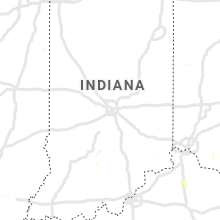
Indiana
| Local Time | Report Details |
|---|---|
| 5:02 PM EDT | Structural damage to outbuilding. roof of barn blown off. time estimated using radar dat in ripley county IN, 39.8 miles WSW of Cincinnati, OH |
| 5:33 PM EDT | Tree down. time estimated by rada in switzerland county IN, 25.4 miles SW of Cincinnati, OH |
| 7:20 PM EDT | Several trees down in rush county and rushville. most of rushville is without power. time is estimated from rada in rush county IN, 38.8 miles ESE of Indianapolis, IN |
| 7:20 PM EDT | Several trees down in rush county and rushville. time is estimated from rada in rush county IN, 42.5 miles ESE of Indianapolis, IN |
| 7:20 PM EDT | North of us 52 and east 5th street in rushville a tree was blown down into a house. most of rushville is without power. time is estimated from rada in rush county IN, 39.4 miles ESE of Indianapolis, IN |
Massachusetts
| Local Time | Report Details |
|---|---|
| 5:10 PM EDT | 6 inch branch down on elm street in hampden county MA, 67 miles WNW of Providence, RI |
| 5:10 PM EDT | 6 inch branch down on elm street in hampden county MA, 67 miles WNW of Providence, RI |
| 5:15 PM EDT | Tree down on wires on granby roa in hampden county MA, 64.5 miles WNW of Providence, RI |
| 5:20 PM EDT | Large tree and wires down blocking piper road... wires also down on vincent drive...morgan road and smyrna stree in hampden county MA, 67 miles WNW of Providence, RI |
| 5:20 PM EDT | Large tree and wires down blocking piper road... wires also down on vincent drive...morgan road and smyrna stree in hampden county MA, 67 miles WNW of Providence, RI |
| 5:20 PM EDT | Large tree and wires down blocking piper road... wires also down on vincent drive...morgan road and smyrna stree in hampden county MA, 67 miles WNW of Providence, RI |
| 5:23 PM EDT | Large limb down on house on king stree in hampden county MA, 72.8 miles WNW of Providence, RI |
Nebraska
| Local Time | Report Details |
|---|---|
| 4:31 PM CDT | Metal shed/garage blown down report via twitte in gosper county NE, 59.2 miles SE of North Platte, NE |
| 5:50 PM CDT | Half Dollar sized hail reported near Bruning, NE, 57.5 miles SE of Grand Island, NE |
| 6:07 PM CDT | Quarter sized hail reported near Elkhorn, NE, 15.7 miles W of Omaha, NE, nws employee sent in picture of hail the size of quarters. |
| 6:22 PM CDT | Half Dollar sized hail reported near Yutan, NE, 24 miles W of Omaha, NE, corrects previous hail report from yutan. report from twitter. |
| 6:28 PM CDT | Half Dollar sized hail reported near Omaha, NE, 13.1 miles W of Omaha, NE, located at 17th and maple. |
| 6:36 PM CDT | Tennis Ball sized hail reported near Valley, NE, 21.7 miles W of Omaha, NE, report passed along by broadcast media. time estimated based on radar data. |
| 6:37 PM CDT | Hen Egg sized hail reported near Valley, NE, 21.1 miles W of Omaha, NE, caller reported 2 hailstone. |
| 6:40 PM CDT | Peak wind gust of 60 mph was measured at nws omah in douglas county NE, 22.7 miles W of Omaha, NE |
| 6:43 PM CDT | Ping Pong Ball sized hail reported near Valley, NE, 22.7 miles W of Omaha, NE, hail the size of ping pong balls was observed at nws omaha. |
| 6:45 PM CDT | Quarter sized hail reported near Nelson, NE, 48.2 miles SSE of Grand Island, NE |
| 7:07 PM CDT | 60 mph measured from mesonet site up34 in washington county NE, 21.5 miles NW of Omaha, NE |
| 7:11 PM CDT | Report from mping: 3-inch tree limbs broken; power poles broke in washington county NE, 22.9 miles WNW of Omaha, NE |
| 2:26 AM CDT | Heat burst observed by kvtn asos. thundershowers in the vicinit in cherry county NE, 0.3 miles S of Valentine, NE |
| 3:39 AM CDT | Storm damage reported in cherry county NE, 0.3 miles S of Valentine, NE |
| 3:45 AM CDT | Storm damage reported in cherry county NE, 1.1 miles ENE of Valentine, NE |
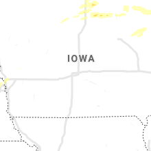
Iowa
| Local Time | Report Details |
|---|---|
| 4:52 PM CDT | Delayed report: some tree damage reported around the clear lake area. power outages also reported. time estimated via rada in cerro gordo county IA, 11.4 miles WSW of Mason City, IA |
| 4:54 PM CDT | Small tree limbs down... 1-3 inches in diameter. knocked down a powerline as well. from social media pictur in cerro gordo county IA, 20.7 miles SW of Mason City, IA |
| 5:08 PM CDT | Em reports a few tree limbs down around town... some damage to power lines. time estimated via rada in cerro gordo county IA, 0.6 miles SW of Mason City, IA |
| 5:12 PM CDT | Trees down. not all trees were completely healthy... some were. time estimated via rada in cerro gordo county IA, 15.3 miles SSW of Mason City, IA |
| 5:16 PM CDT | Em reports tree damage south of swaledale area. time estimated via rada in cerro gordo county IA, 13.4 miles SSW of Mason City, IA |
| 6:36 PM CDT | Damage to corn and telephone pole in chickasaw county IA, 37.3 miles ESE of Mason City, IA |
| 6:55 PM CDT | Lots of power outages across the southern part of the county from winds causing downed power lines to lightning strikes. communities impacted include spillville... fort in winneshiek county IA, 54.9 miles SW of La Crosse, WI |
| 7:42 PM CDT | Power lines dow in allamakee county IA, 53 miles SSW of La Crosse, WI |
| 8:07 PM CDT | Report of powerlines dow in clayton county IA, 53.1 miles S of La Crosse, WI |
| 3:15 AM CDT | Report of numerous tree branches and some larger trees dow in story county IA, 30.5 miles N of Des Moines, IA |
Ohio
| Local Time | Report Details |
|---|---|
| 5:53 PM EDT | Trees down. time estimated by rada in hamilton county OH, 8.9 miles E of Cincinnati, OH |
| 5:55 PM EDT | Power poles down. time estimated by radar along outflow boundar in clermont county OH, 16.2 miles ESE of Cincinnati, OH |
| 5:57 PM EDT | Power poles down. time estimated by radar- likely along outflow boundar in clermont county OH, 25 miles ESE of Cincinnati, OH |
| 6:00 PM EDT | Power poles down. time estimated by radar along outflow boundar in clermont county OH, 17.5 miles E of Cincinnati, OH |
| 6:23 PM EDT | Local broadcast meteorologist reported trees down and power lines dow in warren county OH, 17.8 miles NE of Cincinnati, OH |
| 6:23 PM EDT | Trees down and power poles down in hamilton county OH, 16.6 miles NE of Cincinnati, OH |
Montana
| Local Time | Report Details |
|---|---|
| 4:40 PM MDT | Quarter sized hail reported near Glasgow, MT, 32.9 miles NNE of Glasgow, MT |
Alabama
| Local Time | Report Details |
|---|---|
| 6:01 PM CDT | Trees and powerlines dow in lee county AL, 21.8 miles ESE of Auburn, AL |
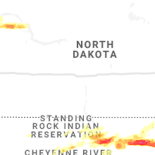
North Dakota
| Local Time | Report Details |
|---|---|
| 6:36 PM CDT | Quarter sized hail reported near Watford City, ND, 27.6 miles SE of Williston, ND, a lot of small hail with the largest stone 1 inch. hail damaged a pickup truck. report relayed via social media. |
| 6:40 PM CDT | Ping Pong Ball sized hail reported near Alamo, ND, 34.1 miles NNE of Williston, ND, report relayed via emergency management. |
| 7:38 PM CDT | Radar estimated tim in mountrail county ND, 51.1 miles ESE of Williston, ND |
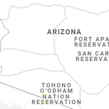
Arizona
| Local Time | Report Details |
|---|---|
| 4:36 PM MST | Asos station ksad safford regional airpor in graham county AZ, 79 miles W of Silver City, NM |
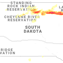
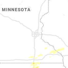
South Dakota
| Local Time | Report Details |
|---|---|
| 5:42 PM MDT | Storm damage reported in butte county SD, 71.1 miles N of Rapid City, SD |
| 5:42 PM MDT | Quarter sized hail reported near Newell, SD, 71.1 miles N of Rapid City, SD |
| 6:30 PM MDT | Storm damage reported in perkins county SD, 78.8 miles NNE of Rapid City, SD |
| 1:56 AM CDT | Quarter sized hail reported near Selby, SD, 74.2 miles W of Aberdeen, SD |
| 2:32 AM CDT | Tennis Ball sized hail reported near Selby, SD, 72.7 miles W of Aberdeen, SD, numerous hailstones up to tennis ball sized and decreased to golf ball sized before ending. ground was white with hail. |
| 4:08 AM CDT | Tennis Ball sized hail reported near Ipswich, SD, 17.9 miles WSW of Aberdeen, SD, measured tennis ball sized hail. several windows broken on house. hail is covering the ground. |
| 4:30 AM CDT | Ping Pong Ball sized hail reported near Mansfield, SD, 11 miles SW of Aberdeen, SD |
| 4:34 AM CDT | Golf Ball sized hail reported near Warner, SD, 8.9 miles S of Aberdeen, SD, hailing for the last 10 minutes. |
| 6:03 AM CDT | Golf Ball sized hail reported near Webster, SD, 47.8 miles ESE of Aberdeen, SD, golf ball sized hail is ongoing. |
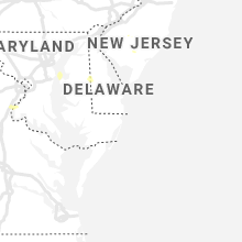
Delaware
| Local Time | Report Details |
|---|---|
| 9:04 PM EDT | Downed tree on wires near hayfield road. time estimated from rada in kent county DE, 53.8 miles NW of Ocean City, MD |
Connect with Interactive Hail Maps