

Hail Map for Sunday, August 28, 2016

Number of Impacted Households on 8/28/2016
0
Impacted by 1" or Larger Hail
0
Impacted by 1.75" or Larger Hail
0
Impacted by 2.5" or Larger Hail
Square Miles of Populated Area Impacted on 8/28/2016
0
Impacted by 1" or Larger Hail
0
Impacted by 1.75" or Larger Hail
0
Impacted by 2.5" or Larger Hail


Cities Most Affected by Hail Storms of 8/28/2016
| Hail Size | Demographics of Zip Codes Affected | ||||||
|---|---|---|---|---|---|---|---|
| City | Count | Average | Largest | Pop Density | House Value | Income | Age |
| Logansport, IN | 2 | 1.75 | 1.75 | 156 | $68k | $36.2k | 37.7 |
Hail and Wind Damage Spotted on 8/28/2016
Filter by Report Type:Hail ReportsWind Reports
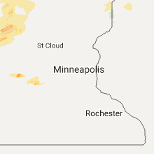
States Impacted
Minnesota, Indiana, Kentucky, New York, Georgia, Pennsylvania, Ohio, Tennessee, Nebraska, Vermont, Texas, Alabama, Kansas, Missouri, Iowa, South Dakota, New Hampshire, West VirginiaMinnesota
| Local Time | Report Details |
|---|---|
| 7:10 AM CDT | Quarter sized hail reported near Litchfield, MN, 54.8 miles E of Montevideo, MN, quarter sized hail covering the road at intersection of 150th and 570th st. |
| 8:05 AM CDT | 3-4" diameter branches down and penny sized hail at cr 7 and vale av in mcleod county MN, 58.5 miles WSW of Minneapolis, MN |
| 6:25 PM CDT | Quarter sized hail reported near Lake Bronson, MN, 37.3 miles WSW of Roseau, MN |
| 9:37 PM CDT | Quarter sized hail reported near Fertile, MN, 50.8 miles NNE of Fargo, ND |
| 9:53 PM CDT | Quarter sized hail reported near Fertile, MN, 50.8 miles NNE of Fargo, ND, also 60 mph wind |
| 10:20 PM CDT | Quarter sized hail reported near Littlefork, MN, 13.9 miles SSW of International Falls, MN, . |
Indiana
| Local Time | Report Details |
|---|---|
| 2:20 PM EDT | Isolated area of damage to multiple large trees. some tree tops snapped... one tree uprooted. along 24961 cr 20/mishawaka rd. previously submitted with incorrect locati in elkhart county IN, 58.6 miles NW of Fort Wayne, IN |
| 2:55 PM EDT | Isolated area of wind damage to multiple large trees. some tree tops snapped... one tree uprooted. no word on the health or size of trees. reported on cr 2 in st. joseph county IN, 70 miles NW of Fort Wayne, IN |
| 4:15 PM EDT | Quarter sized hail reported near Monticello, IN, 81.4 miles NNW of Indianapolis, IN, quarter sized hail on 700 n just west of 800 e. |
| 5:13 PM EDT | Golf Ball sized hail reported near Logansport, IN, 69.8 miles N of Indianapolis, IN, emergency manager relayed report from a spotter on us-24. |
| 5:15 PM EDT | Multiple trees and fences down. multiple trees snapped off. large sign on hwy 24 down across westbound lane in cass county IN, 67.6 miles N of Indianapolis, IN |
| 5:20 PM EDT | Several reports of wind damage around logansport... and reports of golf ball sized hail. estimated 60-70 mph wind in cass county IN, 68.7 miles N of Indianapolis, IN |
| 5:20 PM EDT | Limbs/trees downed near the high school. mentioned hail also occurred-about nickle sized from nearby picture in cass county IN, 68.2 miles WSW of Fort Wayne, IN |
| 5:20 PM EDT | Golf Ball sized hail reported near Logansport, IN, 68.7 miles N of Indianapolis, IN, . |
| 5:52 PM EDT | Reports of trees down in onward. estimated 6-12" diameter for tree in cass county IN, 63.5 miles WSW of Fort Wayne, IN |
| 6:05 PM EDT | 10 inch tree down at a residence near the intersection of main st. and elm stree in miami county IN, 59.8 miles WSW of Fort Wayne, IN |
| 6:29 PM EDT | Several trees downed and one is on a vacant house (no injuries). scattered power outage in miami county IN, 55.1 miles WSW of Fort Wayne, IN |
| 6:45 PM EDT | 2 inch limbs down plus dime size hai in grant county IN, 48 miles SW of Fort Wayne, IN |
| 6:50 PM EDT | Sr 18 and 600 in grant county IN, 50.3 miles SW of Fort Wayne, IN |
| 7:03 PM EDT | Quarter sized hail reported near Marion, IN, 46.9 miles SW of Fort Wayne, IN, near meridian rd and sr 15. |
| 7:05 PM EDT | Quarter sized hail reported near Gas City, IN, 46.8 miles SSW of Fort Wayne, IN, . |
| 7:08 PM EDT | Trees downed on power line in grant county IN, 49.6 miles SW of Fort Wayne, IN |
| 7:20 PM EDT | Power lines downed on 500 in grant county IN, 51.2 miles SSW of Fort Wayne, IN |
| 7:26 PM EDT | Tree down along s 600 e near cr 975 in grant county IN, 51.3 miles SSW of Fort Wayne, IN |
| 8:00 PM EDT | Quarter sized hail reported near Anderson, IN, 33.1 miles NE of Indianapolis, IN, near 38th and satterfield |
| 8:35 PM EDT | Trees down. roof off small bar in orange county IN, 61.1 miles NW of Louisville, KY |
| 9:00 PM CDT | Possible microburst near the new lake campground. lots of tree damage and damage to camper in gibson county IN, 27.1 miles NNE of Evansville, IN |
| 11:05 PM EDT | Tree reported down on a house in monroe city. no injuries reported in knox county IN, 45.2 miles NNE of Evansville, IN |
| 11:10 PM EDT | Tree down across hickory corner rd between st rd 241 and monroe school road in knox county IN, 45.2 miles NNE of Evansville, IN |
| 11:10 PM EDT | Tree down on meier circle. no damage to property. time estimate in knox county IN, 48.6 miles N of Evansville, IN |
Kentucky
| Local Time | Report Details |
|---|---|
| 3:00 PM EDT | Tree down in masterson statio in fayette county KY, 42.2 miles NW of Irvine, KY |
| 3:30 PM EDT | Trees dow in franklin county KY, 53.5 miles ENE of Louisville, KY |
| 4:45 PM EDT | Tree dow in madison county KY, 19.2 miles WSW of Irvine, KY |
| 5:37 PM EDT | Large pine tree downed and shingles blown off roo in pulaski county KY, 57 miles SW of Irvine, KY |
| 6:15 PM EDT | A tree fell down over a pickup and onto a house. wind speed estimated in excess of 50 mph. 0.75" hail also fell at this locatio in trimble county KY, 52.9 miles NNE of Louisville, KY |
New York
| Local Time | Report Details |
|---|---|
| 3:19 PM EDT | Shed blown onto grauer roa in niagara county NY, 17.8 miles NNW of Buffalo, NY |
| 3:32 PM EDT | Powerlines down at 2781 lockport roa in niagara county NY, 16.2 miles N of Buffalo, NY |
| 3:38 PM EDT | Powerlines down at 5150 shawnee roa in niagara county NY, 19.1 miles N of Buffalo, NY |
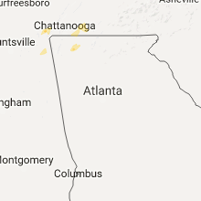
Georgia
| Local Time | Report Details |
|---|---|
| 3:32 PM EDT | Several trees reported down on roads in the rocky face and tunnel hill areas...including mill creek road...beaverdale road...tate road...mcarthur road...and lafayette r in whitfield county GA, 25.7 miles SE of Chattanooga, TN |
| 3:36 PM EDT | One large hardwood tree down at a residence on pat clebourne lane in tunnel hil in whitfield county GA, 21.8 miles SE of Chattanooga, TN |
Pennsylvania
| Local Time | Report Details |
|---|---|
| 3:40 PM EDT | Trees down near karthu in clearfield county PA, 25.7 miles NNW of State College, PA |
| 4:00 PM EDT | Trees down in east-central clearfield county between chester hill and morrisdal in clearfield county PA, 22.1 miles WNW of State College, PA |
| 7:00 PM EDT | Tree down on lawsonham road in armstrong county PA, 46.2 miles NE of Pittsburgh, PA |
| 7:05 PM EDT | Trees down on carnegie mellon university campus. time estimated from rada in allegheny county PA, 0.9 miles E of Pittsburgh, PA |
| 7:10 PM EDT | Quarter sized hail reported near Pittsburgh, PA, 2.6 miles ESE of Pittsburgh, PA |
| 7:20 PM EDT | Couple of trees and wires down in westmoreland county PA, 19.4 miles ENE of Pittsburgh, PA |
| 7:25 PM EDT | Numerous trees and wires down in westmoreland county PA, 18 miles ENE of Pittsburgh, PA |
| 7:25 PM EDT | Tree down on dutchman run road and roadway flooded. time estimate in westmoreland county PA, 16.5 miles ENE of Pittsburgh, PA |
| 7:32 PM EDT | Several trees down in westmoreland county PA, 21.4 miles NE of Pittsburgh, PA |
| 7:37 PM EDT | Tree down at bethesda dr/schaffer dr intersection in westmoreland county PA, 20.3 miles ENE of Pittsburgh, PA |
| 7:37 PM EDT | Trees down in westmoreland county PA, 22.2 miles NE of Pittsburgh, PA |
| 7:56 PM EDT | Trees and power pole down in washington county PA, 15.2 miles S of Pittsburgh, PA |
| 8:38 PM EDT | Several trees down in the derry and ligonier area in westmoreland county PA, 38.2 miles ESE of Pittsburgh, PA |
| 8:39 PM EDT | Tree down on tippecanoe road in fayette county PA, 31.2 miles SSE of Pittsburgh, PA |
| 8:54 PM EDT | Tree and wires down on rowes run road in fayette county PA, 31.8 miles SSE of Pittsburgh, PA |
Ohio
| Local Time | Report Details |
|---|---|
| 4:23 PM EDT | Numerous reports of trees and limbs down across the eastern half of the county. time was radar estimat in erie county OH, 43.4 miles WSW of Cleveland, OH |
| 4:30 PM EDT | Storm damage reported in erie county OH, 45.2 miles W of Cleveland, OH |
| 4:36 PM EDT | 6-14 inch branches down in volunteer bay. public report from twitter. time estimated from rada in erie county OH, 38.6 miles W of Cleveland, OH |
| 4:38 PM EDT | Freshly snapped trees south side of i80. time estimated from rada in erie county OH, 36.1 miles WSW of Cleveland, OH |
| 4:55 PM EDT | Numerous trees and power lines dow in lorain county OH, 31.2 miles WSW of Cleveland, OH |
| 5:38 PM EDT | Numerous trees down near lake tomahawk in columbiana county OH, 38.7 miles NW of Pittsburgh, PA |
| 5:40 PM EDT | Numerous trees uprooted fenn and abbyville. reported by medina county em in medina county OH, 25.3 miles SSW of Cleveland, OH |
| 5:44 PM EDT | Multiple trees downe in medina county OH, 26.2 miles SSW of Cleveland, OH |
| 5:55 PM EDT | Several trees down. time estimated from rada in adams county OH, 47.4 miles ESE of Cincinnati, OH |
| 6:01 PM EDT | Multiple trees down around the town of rogers in columbiana county OH, 40.7 miles NW of Pittsburgh, PA |
| 6:06 PM EDT | Trees down. time estimated by radar in holmes county OH, 64.5 miles S of Cleveland, OH |
| 6:10 PM EDT | Four 4' diameter trees down on us 224 at van wert decatur rd. took 4 poles & phone lines down blocking us224. several large limbs down als in van wert county OH, 28.7 miles ESE of Fort Wayne, IN |
| 6:25 PM EDT | Trees dow in holmes county OH, 68 miles S of Cleveland, OH |
| 7:20 PM EDT | Tree fell on power lines. flagpole bent/broke near the ground. numerous 1-2 inch branches down throughout cit in franklin county OH, 6.6 miles SSE of Columbus, OH |
| 7:30 PM EDT | 2 ft diameter tree uprooted. another 2 ft diameter tree snapped and fell on house. widespread cornfield damag in ross county OH, 49.1 miles SSE of Columbus, OH |
| 8:35 PM EDT | 1 tree down. time estimated from rada in greene county OH, 51.6 miles NNE of Cincinnati, OH |
| 8:35 PM EDT | Several trees down between bellefontaine and west liberty. time estimated from rada in logan county OH, 46.7 miles WNW of Columbus, OH |
| 10:59 PM EDT | Freshly snapped trees south side of i80. time estimated from rada in erie county OH, 36.1 miles WSW of Cleveland, OH |
Tennessee
| Local Time | Report Details |
|---|---|
| 4:24 PM EDT | Tree down across hwy 92 in grainger county TN, 26.6 miles NE of Knoxville, TN |
| 4:25 PM EDT | Couple trees down on a hous in hamilton county TN, 6.4 miles ENE of Chattanooga, TN |
| 4:39 PM EDT | Couple trees down along highway 6 in bradley county TN, 32.4 miles ENE of Chattanooga, TN |
| 4:43 PM EDT | Trees down from thunderstorm wind in bradley county TN, 25.9 miles ENE of Chattanooga, TN |
| 4:50 PM EDT | Trees down across union count in union county TN, 26.9 miles NNE of Knoxville, TN |
| 5:20 PM EDT | Couple of trees down along the knox/union county lin in knox county TN, 13.9 miles N of Knoxville, TN |
| 5:25 PM EDT | A few trees and power lines dow in knox county TN, 13.1 miles N of Knoxville, TN |
| 5:35 PM EDT | Trees and power lines dow in campbell county TN, 29.4 miles NW of Knoxville, TN |
Nebraska
| Local Time | Report Details |
|---|---|
| 3:40 PM CDT | Storm damage reported in otoe county NE, 40.3 miles S of Omaha, NE |
| 3:43 PM CDT | Storm damage reported in otoe county NE, 45.7 miles S of Omaha, NE |
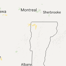
Vermont
| Local Time | Report Details |
|---|---|
| 5:02 PM EDT | Tree branches down in grand isle county VT, 12.8 miles NNW of Burlington, VT |
| 5:08 PM EDT | Trees down on bog road in lamoille county VT, 32 miles NE of Burlington, VT |
| 5:45 PM EDT | Trees down in johnson in lamoille county VT, 28.7 miles ENE of Burlington, VT |
| 6:24 PM EDT | Tree branches through a roof in grand isle county VT, 28.8 miles N of Burlington, VT |
| 6:50 PM EDT | Trees down on lower newton road in franklin county VT, 24 miles NNE of Burlington, VT |
| 6:54 PM EDT | Tree down on rte 5 near sawmill lane. time estimated from rada in caledonia county VT, 59.5 miles E of Burlington, VT |
| 6:54 PM EDT | Tree down on rte 5. time estimated from rada in caledonia county VT, 61.5 miles E of Burlington, VT |
| 7:42 PM EDT | Trees on high voltage wires and down across both lanes of us hwy in essex county VT, 75.8 miles E of Burlington, VT |
Texas
| Local Time | Report Details |
|---|---|
| 4:05 PM CDT | Storm damage reported in gray county TX, 59.5 miles NNW of Childress, TX |
Alabama
| Local Time | Report Details |
|---|---|
| 4:20 PM CDT | Tree reported down on county road 18 in dutton. relayed via the sheriffs office after the fire department removed the tre in jackson county AL, 45.9 miles SW of Chattanooga, TN |
| 4:30 PM CDT | A tree was downed on county road 75 near highway 273. winds estimated around 40mp in cherokee county AL, 54.3 miles SSW of Chattanooga, TN |
| 6:30 PM CDT | Several trees down...including some on houses and vehicles...between al hwy 36 and al hwy 67 in the fowler cove area. some power poles leaning. damage to storage she in morgan county AL, 60.6 miles ESE of Florence, AL |
| 7:30 PM CDT | Several barns damaged...which caused damage to the basement windows of a nearby house. time from resident repor in cullman county AL, 40.4 miles N of Birmingham, AL |
Kansas
| Local Time | Report Details |
|---|---|
| 5:01 PM CDT | Quarter sized hail reported near Emporia, KS, 61 miles NW of Chanute, KS, a few quarter size stones fell...asos at the airport had gusted up to 50mph at 452pm also. |
| 5:24 PM CDT | Trained spotter reports a burst of wind broke 3 to 4 inch limbs from a tree in her yar in kingman county KS, 40.8 miles W of Wichita, KS |
Missouri
| Local Time | Report Details |
|---|---|
| 5:11 PM CDT | Storm damage reported in atchison county MO, 63.8 miles SSE of Omaha, NE |
| 7:20 PM CDT | Tree snapped in half fell onto power line. numerous large tree branches down across the northern part of the cit in grundy county MO, 84.8 miles NE of Kansas City, MO |
Iowa
| Local Time | Report Details |
|---|---|
| 6:06 PM CDT | 6 to 8 inch tree limb down on a powerline at sw 1st and davis ave. time estimated from rada in polk county IA, 2.1 miles S of Des Moines, IA |
South Dakota
| Local Time | Report Details |
|---|---|
| 6:45 PM CDT | Quarter sized hail reported near Ipswich, SD, 23.5 miles WSW of Aberdeen, SD, . |
| 7:20 PM CDT | Quarter sized hail reported near Ipswich, SD, 28.1 miles WSW of Aberdeen, SD, . |
| 7:25 PM CDT | Quarter sized hail reported near Ipswich, SD, 31.8 miles WSW of Aberdeen, SD, . |
| 7:45 PM CDT | Quarter sized hail reported near Ipswich, SD, 25.8 miles WSW of Aberdeen, SD, . |
New Hampshire
| Local Time | Report Details |
|---|---|
| 7:50 PM EDT | Trees on wires... trees blocking roads route 135 and 142. in whtefiel in coos county NH, 79.6 miles E of Burlington, VT |
West Virginia
| Local Time | Report Details |
|---|---|
| 8:10 PM EDT | Numerous trees down blocking fork ridge road towards route 250 in marshall county WV, 50.2 miles SW of Pittsburgh, PA |
| 8:15 PM EDT | 2 trees down on route 891 in marshall county WV, 48 miles SW of Pittsburgh, PA |
Connect with Interactive Hail Maps