

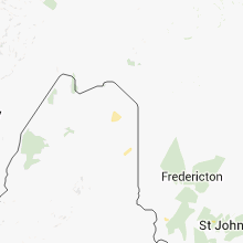
Hail Map for Sunday, August 4, 2013

Number of Impacted Households on 8/4/2013
0
Impacted by 1" or Larger Hail
0
Impacted by 1.75" or Larger Hail
0
Impacted by 2.5" or Larger Hail
Square Miles of Populated Area Impacted on 8/4/2013
0
Impacted by 1" or Larger Hail
0
Impacted by 1.75" or Larger Hail
0
Impacted by 2.5" or Larger Hail


Cities Most Affected by Hail Storms of 8/4/2013
| Hail Size | Demographics of Zip Codes Affected | ||||||
|---|---|---|---|---|---|---|---|
| City | Count | Average | Largest | Pop Density | House Value | Income | Age |
| Cheyenne, WY | 3 | 1.75 | 1.75 | 286 | $91k | $33.7k | 33.4 |
| Mapleton, ME | 1 | 1.75 | 1.75 | 15 | $67k | $35.7k | 44.0 |
Hail and Wind Damage Spotted on 8/4/2013
Filter by Report Type:Hail ReportsWind Reports
States Impacted
Connecticut, Maine, Wyoming, Colorado, Massachusetts, Washington, Arkansas, Montana, Georgia, Florida, Minnesota, South DakotaConnecticut
| Local Time | Report Details |
|---|---|
| 4:00 PM EDT | 3 inch diameter branches dow in tolland county CT, 54.8 miles W of Providence, RI |
| 4:11 PM EDT | A tree and wires down on grant hill roa in tolland county CT, 49.5 miles W of Providence, RI |
Maine
| Local Time | Report Details |
|---|---|
| 4:20 PM EDT | Quarter sized hail reported near Caribou, ME, 6.5 miles WNW of Caribou, ME, hail ranged from 1/2 to 1 inch in diameter. reported via facebook. |
| 5:00 PM EDT | Golf Ball sized hail reported near Mapleton, ME, 14.3 miles SSW of Caribou, ME, report via facebook of golf ball sized hail that quickly turned to penny sized. |
| 6:28 PM EDT | Quarter sized hail reported near Kennebunkport, ME, 22.2 miles SW of Portland, ME |
Wyoming
| Local Time | Report Details |
|---|---|
| 3:12 PM MDT | Quarter sized hail reported near Cheyenne, WY, 43.1 miles ESE of Laramie, WY, one inch diameter was observed at the cheyenne airport. |
| 3:15 PM MDT | Ping Pong Ball sized hail reported near Cheyenne, WY, 45.2 miles ESE of Laramie, WY |
| 3:17 PM MDT | Golf Ball sized hail reported near Cheyenne, WY, 43.1 miles ESE of Laramie, WY, in town south of i-80 |
| 3:18 PM MDT | Golf Ball sized hail reported near Cheyenne, WY, 43.1 miles ESE of Laramie, WY, in southeast part of town |
| 3:26 PM MDT | Quarter sized hail reported near Cheyenne, WY, 47.7 miles ESE of Laramie, WY |
| 3:26 PM MDT | Quarter sized hail reported near Cheyenne, WY, 47.8 miles ESE of Laramie, WY |
| 3:26 PM MDT | Golf Ball sized hail reported near Cheyenne, WY, 45.9 miles ESE of Laramie, WY |
| 9:50 PM MDT | Quarter sized hail reported near Gillette, WY, 19.3 miles WSW of Gillette, WY |
Colorado
| Local Time | Report Details |
|---|---|
| 3:55 PM MDT | Quarter sized hail reported near Colorado Springs, CO, 48.4 miles N of Pueblo, CO |
| 4:15 PM MDT | Quarter sized hail reported near Colorado Springs, CO, 46.3 miles N of Pueblo, CO |
Massachusetts
| Local Time | Report Details |
|---|---|
| 6:12 PM EDT | Tree down on a car on elm street. a window broken on main street...presumably from combination of wind and hai in hampden county MA, 67 miles WNW of Providence, RI |
| 6:12 PM EDT | Half Dollar sized hail reported near West Springfield, MA, 67 miles WNW of Providence, RI, quarter to half dollar size hail in main street area...accumulated up to 2 inches in spots. car with numerous hail dents on fairview ave. multiple reports of nickel siz |
| 6:12 PM EDT | Quarter sized hail reported near West Springfield, MA, 67 miles WNW of Providence, RI, quarter size hail in main street area...accumulated up to 2 inches in spots. multiple reports of nickel size hail in riverdale road area. |
| 6:22 PM EDT | Quarter sized hail reported near Springfield, MA, 61.6 miles WNW of Providence, RI, dime and quarter size hail...covering parts of the driveway. |
| 6:27 PM EDT | Quarter sized hail reported near Longmeadow, MA, 61.7 miles WNW of Providence, RI, quarter size hail. |
Washington
| Local Time | Report Details |
|---|---|
| 3:30 PM PDT | 1 tree down across jackknife road. time estimated based on radar and diameter of the tree unknow in ferry county WA, 64.3 miles ENE of Omak, WA |
| 3:30 PM PDT | 1 tree down across jackknife road. time estimated based on radar. tree was a spruce and estimated to be one foot in diameter and 60 to 70 feet tal in ferry county WA, 64.3 miles ENE of Omak, WA |
Arkansas
| Local Time | Report Details |
|---|---|
| 5:55 PM CDT | Large tree limb blocking the road north of natural dam near mountian fork cree in crawford county AR, 19.1 miles N of Fort Smith, AR |
Montana
| Local Time | Report Details |
|---|---|
| 4:55 PM MDT | Quarter sized hail reported near Antelope, MT, 52.6 miles NW of Williston, ND, hailstones quarter-size and smaller. accompanied by heavy rain. |
Georgia
| Local Time | Report Details |
|---|---|
| 7:00 PM EDT | 2 trees reported blown down by thunderstor in decatur county GA, 37 miles NNW of Tallahassee, FL |
Florida
| Local Time | Report Details |
|---|---|
| 6:40 PM CDT | Trees blown down at baker creek rd near jenny l in jackson county FL, 64.8 miles WNW of Tallahassee, FL |
| 7:00 PM CDT | Trees blown dow in jackson county FL, 56.6 miles WNW of Tallahassee, FL |
Minnesota
| Local Time | Report Details |
|---|---|
| 12:30 AM CDT | Quarter sized hail reported near Tracy, MN, 56.8 miles S of Montevideo, MN |
| 2:00 AM CDT | Many branches and a tree blown down. delayed report. time estimate in martin county MN, 73.2 miles NNE of Storm Lake, IA |
South Dakota
| Local Time | Report Details |
|---|---|
| 12:45 AM MDT | Storm damage reported in pennington county SD, 9.1 miles SSW of Rapid City, SD |
| 2:00 AM MDT | Storm damage reported in pennington county SD, 35.1 miles ESE of Rapid City, SD |
Connect with Interactive Hail Maps