

Hail Map for Monday, August 4, 2014

Number of Impacted Households on 8/4/2014
0
Impacted by 1" or Larger Hail
0
Impacted by 1.75" or Larger Hail
0
Impacted by 2.5" or Larger Hail
Square Miles of Populated Area Impacted on 8/4/2014
0
Impacted by 1" or Larger Hail
0
Impacted by 1.75" or Larger Hail
0
Impacted by 2.5" or Larger Hail


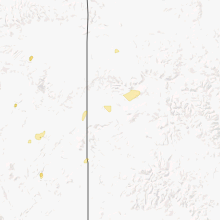


Cities Most Affected by Hail Storms of 8/4/2014
| Hail Size | Demographics of Zip Codes Affected | ||||||
|---|---|---|---|---|---|---|---|
| City | Count | Average | Largest | Pop Density | House Value | Income | Age |
Hail and Wind Damage Spotted on 8/4/2014
Filter by Report Type:Hail ReportsWind Reports
Mississippi
| Local Time | Report Details |
|---|---|
| 3:05 PM CDT | Report of a tree blown down on mountain creek road...causing damage on a playgroun in rankin county MS, 15.1 miles S of Jackson, MS |
| 3:17 PM CDT | A few trees were down along hwy 16 in leake county MS, 44.6 miles NE of Jackson, MS |
| 3:55 PM CDT | A tree and a power line down along billy fields rd in hinds county MS, 18.8 miles W of Jackson, MS |
Michigan
| Local Time | Report Details |
|---|---|
| 5:18 PM EDT | Quarter sized hail reported near Saint Clair Shores, MI, 54.1 miles SE of Flint, MI |
| 5:25 PM EDT | Quarter sized hail reported near Grosse Pointe, MI, 56.8 miles SE of Flint, MI |
Illinois
| Local Time | Report Details |
|---|---|
| 5:36 PM CDT | Quarter sized hail reported near La Fayette, IL, 35.4 miles NW of Peoria, IL |
| 7:13 PM CDT | Tree limbs and power lines down. report via twitter. time estimate in tazewell county IL, 5 miles S of Peoria, IL |
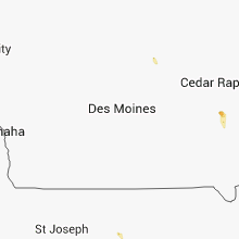
Iowa
| Local Time | Report Details |
|---|---|
| 6:53 PM CDT | Quarter sized hail reported near Coralville, IA, 20.1 miles S of Cedar Rapids, IA, reported via twitter. |
Connect with Interactive Hail Maps