

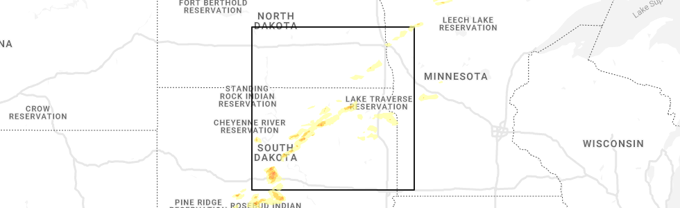
Hail Map for Friday, August 5, 2022
Number of Impacted Households on 8/5/2022
0
Impacted by 1" or Larger Hail
0
Impacted by 1.75" or Larger Hail
0
Impacted by 2.5" or Larger Hail
Square Miles of Populated Area Impacted on 8/5/2022
0
Impacted by 1" or Larger Hail
0
Impacted by 1.75" or Larger Hail
0
Impacted by 2.5" or Larger Hail


Cities Most Affected by Hail Storms of 8/5/2022
| Hail Size | Demographics of Zip Codes Affected | ||||||
|---|---|---|---|---|---|---|---|
| City | Count | Average | Largest | Pop Density | House Value | Income | Age |
| Faulkton, SD | 2 | 2.13 | 2.50 | 1 | $43k | $29.4k | 44.1 |
| Langford, SD | 1 | 2.00 | 2.00 | 2 | $27k | $30.4k | 49.2 |
Hail and Wind Damage Spotted on 8/5/2022
Filter by Report Type:Hail ReportsWind Reports
States Impacted
West Virginia, New Hampshire, Massachusetts, Virginia, Florida, Texas, Tennessee, Maryland, District of Columbia, Delaware, Pennsylvania, Kentucky, North Carolina, Missouri, New York, Georgia, New Jersey, South Dakota, Minnesota, North Dakota, NebraskaWest Virginia
| Local Time | Report Details |
|---|---|
| 1:57 PM EDT | Tree down near ruddle park off of hwy 22 in pendleton county WV, 32.5 miles ESE of Elkins, WV |
| 7:24 PM EDT | Buchanan county 911 center advised there is a tree down at state line ridge road at the state line. time was estimated by rada in buchanan county VA, 52.3 miles NNE of Bristol, TN |
| 7:47 PM EDT | Mcdowell county 911 reported a tree down on coal heritage road near town of kimball. time estimated by rada in mcdowell county WV, 63.9 miles S of Charleston, WV |
| 7:50 PM EDT | Mcdowell county 911 advised there are several trees down in the town of paynesville. time estimated by rada in mcdowell county WV, 59.4 miles NNE of Bristol, TN |
New Hampshire
| Local Time | Report Details |
|---|---|
| 1:59 PM EDT | Corrects previous tstm wnd dmg report from 1 nnw hollis. multiple reports on social media and broadcast media on storm damage in hollis. trees down across town. time es in hillsborough county NH, 63.9 miles N of Providence, RI |
| 1:59 PM EDT | Corrects previous tstm wnd dmg report from 1 nnw hollis. multiple reports on social media and broadcast media on storm damage in hollis. trees down across town. time es in hillsborough county NH, 63.9 miles N of Providence, RI |
| 2:04 PM EDT | Trees and branches down on north end of nashua near the penichuck. time estimated by rada in hillsborough county NH, 66.8 miles N of Providence, RI |
| 2:14 PM EDT | Trees down in greeley park. branches down on concord street north of downtown. time estimated by rada in hillsborough county NH, 66.1 miles N of Providence, RI |
| 2:40 PM EDT | Tree fell on an accessory building near the golf course. home weather station clocked wind gust at 58mph. time estimated by rada in rockingham county NH, 65.1 miles N of Providence, RI |
| 2:45 PM EDT | Corrects previous tstm wnd dmg report from 4 sse hudson. large branches down across a stretch of dracut road in southern hudson. numerous reports of downed branches and in hillsborough county NH, 61.2 miles N of Providence, RI |
| 4:45 PM EDT | Large branches down across a stretch of dracut road in southern hudson. numerous reports of downed branches and a few trees across town. time estimated by rada in hillsborough county NH, 61.2 miles N of Providence, RI |
Massachusetts
| Local Time | Report Details |
|---|---|
| 2:53 PM EDT | Tree down on high tension wires on billings street... lowell. relayed by amateur radi in middlesex county MA, 57.9 miles N of Providence, RI |
| 2:55 PM EDT | Large branch... estimated 1 foot in diameter down across hildreth street. relayed my amateur radi in middlesex county MA, 58.6 miles N of Providence, RI |
| 2:55 PM EDT | Large tree down blocking portion of merrimack ave per p.d. relayed my amateur radi in middlesex county MA, 58.2 miles N of Providence, RI |
| 3:33 PM EDT | Large branch down on massachusetts ave near kelly corner. relayed by amateur radi in middlesex county MA, 45.3 miles N of Providence, RI |
| 3:35 PM EDT | Tree down at 100 block of main street and 700 block of main street. relayed by amateur radi in middlesex county MA, 43.3 miles N of Providence, RI |
| 3:48 PM EDT | Large limb down at middle road and depot road. relayed by amateur radi in middlesex county MA, 46.3 miles N of Providence, RI |
| 4:09 PM EDT | Tree down blocking the southbound lane of canton ave by dollar lane. relayed by amateur radi in norfolk county MA, 32 miles NNE of Providence, RI |
| 4:15 PM EDT | Tree down on ivring street. relayed by amateur radi in middlesex county MA, 39.3 miles NNE of Providence, RI |
| 4:15 PM EDT | Tree and wires down. relayed by amateur radi in norfolk county MA, 34.1 miles NNE of Providence, RI |
| 4:15 PM EDT | Tree down blocking right lane of the road. relayed by amateur radi in middlesex county MA, 36.1 miles NNE of Providence, RI |
| 4:15 PM EDT | Tree on roadway. relayed by amateur radi in middlesex county MA, 37.5 miles N of Providence, RI |
| 4:15 PM EDT | Tree down on car... no injuries. relayed by amateur radi in middlesex county MA, 34.6 miles N of Providence, RI |
| 4:15 PM EDT | Multiple tree branches down in the roadway. relayed by amateur radi in middlesex county MA, 35.4 miles NNE of Providence, RI |
| 4:17 PM EDT | Tree limb and wires down in front yard of home on willow street. relayed by amateur radi in norfolk county MA, 28.4 miles NNE of Providence, RI |
| 4:28 PM EDT | Multiple tree branches down at adams street at hillsdale. relayed by amateur radi in suffolk county MA, 37.5 miles NNE of Providence, RI |
| 4:37 PM EDT | Large branch blocking half the roadway. relayed by amateur radi in plymouth county MA, 42.1 miles NE of Providence, RI |
| 4:45 PM EDT | Many large trees and limbs down between rt. 9 and rt. 30. parkerville and deerfoot roads closed. relayed by amateur radi in worcester county MA, 33.5 miles N of Providence, RI |
Virginia
| Local Time | Report Details |
|---|---|
| 3:10 PM EDT | Thunderstorm winds blew down several trees along south main street between route 58 and the dan river. a few of them were close to the danville community colleg in city of danville county VA, 56.6 miles SSE of Roanoke, VA |
| 3:15 PM EDT | Trees down on nocks landing r in accomack county VA, 37.3 miles SW of Ocean City, MD |
| 4:05 PM EDT | Trees down near 288 east of manaki in goochland county VA, 6.7 miles N of Richmond, VA |
| 4:07 PM EDT | Tree down near the 100 block of old church r in prince william county VA, 64.2 miles SW of Baltimore, MD |
| 4:10 PM EDT | Trees down east of highway 1 in accomack county VA, 49.5 miles SW of Ocean City, MD |
| 4:10 PM EDT | Thunderstorm winds blew down multiple trees in ridgewa in henry county VA, 47.8 miles S of Roanoke, VA |
| 4:25 PM EDT | Thunderstorm winds blew down multiple trees between bassett and stanleytow in henry county VA, 36 miles S of Roanoke, VA |
| 4:45 PM EDT | Quarter sized hail reported near Midlothian, VA, 6.5 miles S of Richmond, VA, report from mping: quarter (1.00 in.). |
| 4:49 PM EDT | Tree down at the intersection of rober e. lee dr. and seays r in spotsylvania county VA, 48.7 miles N of Richmond, VA |
| 4:55 PM EDT | Large oak tree down on semmes ave blocking the roa in city of richmond county VA, 8.9 miles E of Richmond, VA |
| 5:00 PM EDT | Thunderstorm winds blew down one tree on to the 1000 block of barker roa in henry county VA, 45.1 miles SSE of Roanoke, VA |
| 5:05 PM EDT | Trees down in jonesville. time estimated by rada in lee county VA, 50.4 miles W of Bristol, TN |
| 5:15 PM EDT | Quarter sized hail reported near Onancock, VA, 56 miles SW of Ocean City, MD |
| 5:20 PM EDT | Trees down in dryden. time estimated from rada in lee county VA, 42 miles WNW of Bristol, TN |
| 5:20 PM EDT | Trees and power lines down on holly s in accomack county VA, 56.4 miles SW of Ocean City, MD |
| 5:30 PM EDT | Trees down in duffield. time estimated from rada in scott county VA, 33.3 miles WNW of Bristol, TN |
| 5:30 PM EDT | Trees down in jasper community. time estimated from rada in lee county VA, 35.4 miles WNW of Bristol, TN |
| 5:30 PM EDT | Tree down at wagner road and campground road. another tree down a short distance away on wagner roa in washington county VA, 2.6 miles NE of Bristol, TN |
| 5:40 PM EDT | Tree down blocking both lanes of the roa in washington county VA, 4 miles NE of Bristol, TN |
| 5:41 PM EDT | Tree down on leavells rd. naer smith station r in spotsylvania county VA, 49.1 miles N of Richmond, VA |
| 5:50 PM EDT | Several trees down in fort blackmore. time estimated from rada in scott county VA, 23.9 miles WNW of Bristol, TN |
| 6:00 PM EDT | Trees down in dungannon. time estimated from rada in scott county VA, 21.5 miles NW of Bristol, TN |
| 6:19 PM EDT | Dickenson county 911 advised there is a tree down on poker flats road in nora. time was estimated by rada in dickenson county VA, 28.4 miles NNW of Bristol, TN |
| 6:24 PM EDT | Dickenson county 911 center reported a tree down on dante mountain road in the community of nora. time is estimated by rada in dickenson county VA, 33.7 miles NNW of Bristol, TN |
| 6:25 PM EDT | Thunderstorm winds blew down multiple trees in dalevill in botetourt county VA, 10.3 miles N of Roanoke, VA |
| 6:30 PM EDT | Thunderstorm winds blew down multiple trees in troutvill in botetourt county VA, 10.1 miles NNE of Roanoke, VA |
| 6:36 PM EDT | Buchanan county 911 center advised there is a tree down on patterson road and route 638. time was estimated by rada in buchanan county VA, 47.8 miles NNE of Bristol, TN |
| 6:43 PM EDT | Thunderstorm winds blew down multiple trees in blue ridg in botetourt county VA, 10 miles NE of Roanoke, VA |
| 6:46 PM EDT | Thunderstorm winds blew down multiple trees in buchana in botetourt county VA, 22.3 miles NE of Roanoke, VA |
| 7:00 PM EDT | Virginia state police dispatch advised one of their troopers reported a tree down 1000 block of cydney circle at keen mountain camp road. time estimated by rada in buchanan county VA, 44 miles NNE of Bristol, TN |
| 7:12 PM EDT | Tree reported down on slate creek road blocking two lanes. time estimated from rada in buchanan county VA, 53.1 miles NNE of Bristol, TN |
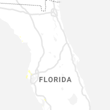
Florida
| Local Time | Report Details |
|---|---|
| 3:22 PM EDT | Duke energy reported power outages off of ne 45th terrace due to trees and limbs blown down onto powerlines. the time of damage was based on rada in marion county FL, 68.8 miles NW of Orlando, FL |
| 3:45 PM EDT | Duke energy utility company reported power outages north of reddick near nw 160th street and nw 43 court due to trees and limbs blown down onto utility equipment. the t in marion county FL, 73.2 miles SSW of Jacksonville, FL |
| 5:20 PM EDT | Quarter sized hail reported near Punta Gorda, FL, 48.3 miles SE of Bradenton, FL, public pictures of nickel to quarter size hail in charlotte harbor reported by broadcast media. |
Texas
| Local Time | Report Details |
|---|---|
| 2:55 PM CDT | *** 1 inj *** corrects previous downburst report from longview. reports of damage on east side of longview including tree falling on vehicle with one injury reported on in gregg county TX, 59.1 miles W of Shreveport, LA |
| 4:30 PM CDT | Widespread wind damage reported across the city of mount pleasant. trees and powerlines were reported down on happy street and near the intersection of hwy 67 and fm 14 in titus county TX, 84.5 miles SW of Nashville, AR |
Tennessee
| Local Time | Report Details |
|---|---|
| 4:20 PM EDT | Several trees and powerlines down in and near chuckey. also some roof damage. time estimated from rada in greene county TN, 37.1 miles SW of Bristol, TN |
| 4:45 PM EDT | Tree down on lovell roa in knox county TN, 13.1 miles WSW of Knoxville, TN |
| 4:46 PM EDT | Tree down and hanging on power line in knox county TN, 8.5 miles WNW of Knoxville, TN |
| 4:50 PM EDT | Tree down at panther creek road and hwy 33. time estimated from rada in hancock county TN, 52.3 miles W of Bristol, TN |
| 4:55 PM EDT | Corrects previous tstm wnd dmg report from 1 n bulls gap. tree down on shepherd driv in hawkins county TN, 51.7 miles ENE of Knoxville, TN |
| 4:56 PM EDT | Trees down in loudon and other parts of loudon county. time estimated from rada in loudon county TN, 29 miles WSW of Knoxville, TN |
| 5:00 PM EDT | Corrects previous tstm wnd dmg report from 4 e sneedville. tree down on chestnut ridge road about 5 miles east of hwy 66. time estimate in hancock county TN, 50.7 miles W of Bristol, TN |
| 5:20 PM EDT | A few trees down in madisonville. time estimated from rada in monroe county TN, 39.1 miles SW of Knoxville, TN |
| 5:20 PM EDT | Tree down and powerlines and covering the whole road. time estimated from rada in blount county TN, 14.4 miles SW of Knoxville, TN |
| 5:25 PM EDT | Several trees down in church hill area. time estimated from rada in hawkins county TN, 27.5 miles W of Bristol, TN |
| 5:38 PM EDT | Tree down in the road us highway 411 and cedar lawn blvd. time estimated from rada in blount county TN, 18.1 miles SSW of Knoxville, TN |
| 6:02 PM EDT | Tree down on old walland highway and wesley woods road. time estimated from rada in blount county TN, 19.2 miles SSE of Knoxville, TN |
Maryland
| Local Time | Report Details |
|---|---|
| 4:22 PM EDT | Quarter sized hail reported near Salisbury, MD, 27 miles WNW of Ocean City, MD |
| 4:44 PM EDT | Tree down onto power lines near the intersection of bowie rd and port tobacco r in charles county MD, 62.9 miles SSW of Baltimore, MD |
| 5:40 PM EDT | Multiple trees down along hailem school road near easton... md. time estimated via rada in talbot county MD, 43.2 miles SE of Baltimore, MD |
| 5:42 PM EDT | Trees down along church lane and three bridge branch road. also reports of hail nearby... though no estimate of hail size was given. time estimated via rada in talbot county MD, 43.4 miles SE of Baltimore, MD |
| 5:45 PM EDT | Tree down at the intersection of md-295 and md-17 in anne arundel county MD, 13.2 miles SW of Baltimore, MD |
| 5:49 PM EDT | Multiple trees down near the intersection of md-295 and md-10 in anne arundel county MD, 10.5 miles SW of Baltimore, MD |
| 6:05 PM EDT | Tree down at the intersection of and ridge rd. md-295 in anne arundel county MD, 7.9 miles SW of Baltimore, MD |
| 6:12 PM EDT | Storm damage reported in anz533 county MD, 51.5 miles SSE of Baltimore, MD |
| 7:07 PM EDT | Tree down in the 5400 block of school house r in charles county MD, 58.5 miles SSW of Baltimore, MD |
| 7:09 PM EDT | Tree down in the 1600 block of stone d in calvert county MD, 44.9 miles S of Baltimore, MD |
District of Columbia
| Local Time | Report Details |
|---|---|
| 4:26 PM EDT | Tree down in the 3900 block of clay pl n in district of columb county DC, 33.1 miles SSW of Baltimore, MD |
| 4:49 PM EDT | Tree down near the instersection of buchanan st se and 10th st n in district of columb county DC, 31.1 miles SW of Baltimore, MD |
| 4:49 PM EDT | Tree down in the 2100 block of lafayette ave n in district of columb county DC, 32.4 miles SW of Baltimore, MD |
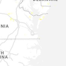
Delaware
| Local Time | Report Details |
|---|---|
| 4:30 PM EDT | 911 call center reports tree limbs down on east grove street in delmar. time estimated via rada in sussex county DE, 27.7 miles WNW of Ocean City, MD |
Pennsylvania
| Local Time | Report Details |
|---|---|
| 4:40 PM EDT | A single tree was downed across west greene rd outside of waterford. time estimated via rada in erie county PA, 80.7 miles SW of Buffalo, NY |
| 5:35 PM EDT | A single tree was downed across old route 86 at lewis road in washington township. time estimated via rada in erie county PA, 89.1 miles ENE of Cleveland, OH |
Kentucky
| Local Time | Report Details |
|---|---|
| 4:52 PM EDT | A tree was downed onto ky-38 approximately 0.5 mile toward harlan from the harlan county detention center. the event time is radar estimate in harlan county KY, 59.5 miles WNW of Bristol, TN |
North Carolina
| Local Time | Report Details |
|---|---|
| 5:02 PM EDT | Thunderstorm winds blew down one tree across the 600 block of riverside driv in rockingham county NC, 52.8 miles S of Roanoke, VA |
| 5:53 PM EDT | Thunderstorm winds blew down one tree near the intersection of bald hill loop and martin farm roa in rockingham county NC, 62.9 miles S of Roanoke, VA |
| 6:10 PM EDT | Thunderstorm winds blew down one tree near the intersection of bethany road and honeysuckle roa in rockingham county NC, 63.6 miles S of Roanoke, VA |
Missouri
| Local Time | Report Details |
|---|---|
| 4:55 PM CDT | Severe thunderstorm wind gusts downed a tree at 1160 south virginia st. in central springfiel in greene county MO, 1.5 miles SSE of Springfield, MO |
| 4:55 PM CDT | Severe thunderstorm wind gusts downed a tree across the intersection of pythian and fremont street in greene county MO, 1.4 miles ENE of Springfield, MO |
New York
| Local Time | Report Details |
|---|---|
| 6:00 PM EDT | Tree down on park ave. via county dispatch feed. radar estimated tim in broome county NY, 46.8 miles NNW of Scranton, PA |
Georgia
| Local Time | Report Details |
|---|---|
| 6:10 PM EDT | Ping Pong Ball sized hail reported near Marietta, GA, 18.1 miles NNW of Atlanta, GA, quarter to as large as ping-pong sized hail was reported on east piedmont rd near sandy plains rd. |
| 6:20 PM EDT | A tree was downed onto an suv on i-575 at the exit to bells ferry road. no injuries reporte in cobb county GA, 22.9 miles NNW of Atlanta, GA |
New Jersey
| Local Time | Report Details |
|---|---|
| 6:36 PM EDT | Trained spotter reports a large tree down. picture provided via social media. time estimated via rada in monmouth county NJ, 40.5 miles SSW of Brooklyn, NY |
| 7:09 PM EDT | Reports of trees down on wires on lakewood-farmingdale road. time estimated via rada in monmouth county NJ, 40.2 miles SSW of Brooklyn, NY |
South Dakota
| Local Time | Report Details |
|---|---|
| 5:40 PM CDT | Radar estimated tim in hughes county SD, 21.5 miles ENE of Pierre, SD |
| 4:46 PM MDT | Storm damage reported in jackson county SD, 69.1 miles NW of Valentine, NE |
| 6:00 PM CDT | Storm damage reported in lyman county SD, 24.1 miles S of Pierre, SD |
| 6:10 PM CDT | Ping Pong Ball sized hail reported near Harrold, SD, 31.9 miles ENE of Pierre, SD |
| 6:20 PM CDT | A semi jack knifed on southbound us 83 from strong winds. radar estimated tim in lyman county SD, 26.9 miles S of Pierre, SD |
| 6:30 PM CDT | Many limbs downed... 3-4 inches of rain... small hai in lyman county SD, 31.1 miles S of Pierre, SD |
| 6:40 PM CDT | Golf Ball sized hail reported near Faulkton, SD, 50.3 miles SW of Aberdeen, SD, 70-80 mph winds. |
| 6:47 PM CDT | Tennis Ball sized hail reported near Faulkton, SD, 52.4 miles SW of Aberdeen, SD, relayed via social media with photo. approximate time and location. |
| 6:59 PM CDT | Mesonet station rfps2 vivian 13 in lyman county SD, 17.4 miles S of Pierre, SD |
| 7:00 PM CDT | Very heavy rainfall also with these storms... with water filling up the ditches in town. power is out in town. radar estimated tim in lyman county SD, 30.4 miles S of Pierre, SD |
| 7:05 PM CDT | Quarter sized hail reported near Mansfield, SD, 14.2 miles SSW of Aberdeen, SD |
| 7:15 PM CDT | Quarter sized hail reported near Mansfield, SD, 15.5 miles SSW of Aberdeen, SD, relayed via social media. |
| 7:18 PM CDT | Ping Pong Ball sized hail reported near Warner, SD, 10.3 miles S of Aberdeen, SD, relayed via social media with photos. |
| 7:33 PM CDT | Half Dollar sized hail reported near Groton, SD, 18.8 miles E of Aberdeen, SD |
| 7:42 PM CDT | Ping Pong Ball sized hail reported near Pierpont, SD, 32.1 miles E of Aberdeen, SD, report from facebook. |
| 7:48 PM CDT | Half Dollar sized hail reported near Ipswich, SD, 13.3 miles W of Aberdeen, SD, relayed via social media with photo. radar estimated time. |
| 7:48 PM CDT | Hen Egg sized hail reported near Langford, SD, 33.4 miles ENE of Aberdeen, SD, relayed via social media with photo. radar estimated time. |
| 7:51 PM CDT | Storm damage reported in brown county SD, 9.3 miles NW of Aberdeen, SD |
| 7:54 PM CDT | Corrects previous non-tstm wnd dmg report from 2 se aberdeen. large tree branch dow in brown county SD, 1.5 miles ESE of Aberdeen, SD |
| 7:57 PM CDT | Kabr aso in brown county SD, 3.3 miles E of Aberdeen, SD |
| 8:10 PM CDT | Some trees blown down. time estimated based on radar. report relayed via social medi in brown county SD, 14.5 miles E of Aberdeen, SD |
| 8:28 PM CDT | Storm damage reported in todd county SD, 43.2 miles NW of Valentine, NE |
| 8:40 PM CDT | Quarter sized hail reported near Faulkton, SD, 36.9 miles SW of Aberdeen, SD |
| 9:53 PM CDT | Time estimated from radar in todd county SD, 43.2 miles NW of Valentine, NE |
| 9:54 PM CDT | Mesonet station 174 clark (sddot in clark county SD, 59.7 miles SE of Aberdeen, SD |
| 10:40 PM CDT | Repair shop and storage shed sustained some damag in codington county SD, 71.3 miles W of Montevideo, MN |
| 10:48 PM CDT | Asos station katy watertown muni a in codington county SD, 70.4 miles W of Montevideo, MN |
| 10:57 PM CDT | Storm damage reported in todd county SD, 15.8 miles N of Valentine, NE |
| 11:12 PM CDT | Storm damage reported in todd county SD, 15.8 miles N of Valentine, NE |
| 12:24 AM CDT | Storm damage reported in roberts county SD, 59.4 miles WNW of Montevideo, MN |
| 12:56 AM CDT | Mesonet station 292 7ne milbank (sddot in grant county SD, 44.6 miles WNW of Montevideo, MN |
| 3:36 AM CDT | Mesonet station 306 3s conde (sddot in spink county SD, 30.6 miles SE of Aberdeen, SD |
Minnesota
| Local Time | Report Details |
|---|---|
| 7:15 PM CDT | Quarter sized hail reported near Moorhead, MN, 2 miles ESE of Fargo, ND, hail near hwy 10 at east edge of moorhead. |
| 7:15 PM CDT | Quarter sized hail reported near Moorhead, MN, 3.6 miles ESE of Fargo, ND |
| 7:35 PM CDT | Wind gusts to 60 mph along with half inch hail. winds gusted until 738 pm cdt in clay county MN, 17.8 miles E of Fargo, ND |
| 7:40 PM CDT | Quarter sized hail reported near Felton, MN, 16.6 miles NE of Fargo, ND, nickel to quarter size hail on and on for 2 to 3 minutes... until 743 pm cdt. |
| 7:55 PM CDT | Quarter sized hail reported near Hawley, MN, 18.1 miles ENE of Fargo, ND, brief burst of hail. |
| 8:15 PM CDT | Quarter sized hail reported near Waubun, MN, 45.8 miles ENE of Fargo, ND, a few quarter sized hail and very strong winds. |
| 8:18 PM CDT | Quarter sized hail reported near Redlake, MN, 28.9 miles NNW of Bemidji, MN, quarter size hail covering the ground. very heavy rain. |
| 8:25 PM CDT | A number of 4 to 6 inch branches broken down. wind gusted for about 5 minute in mahnomen county MN, 49.7 miles WSW of Bemidji, MN |
| 9:03 PM CDT | Quarter sized hail reported near Puposky, MN, 23.5 miles NNW of Bemidji, MN, hail across highway 89 just south of the casino. |
North Dakota
| Local Time | Report Details |
|---|---|
| 9:15 PM CDT | Peak wind measured at the gwinner airport /kgwr in sargent county ND, 61.6 miles SW of Fargo, ND |
| 9:55 PM CDT | Half Dollar sized hail reported near Milnor, ND, 43.3 miles SW of Fargo, ND, sheets of hail in periods of very heavy rain. |
Nebraska
| Local Time | Report Details |
|---|---|
| 11:35 PM CDT | Quarter sized hail reported near Crookston, NE, 10.8 miles WNW of Valentine, NE |
Connect with Interactive Hail Maps