

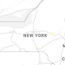
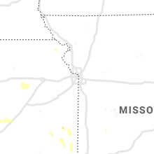
Hail Map for Tuesday, August 6, 2019

Number of Impacted Households on 8/6/2019
0
Impacted by 1" or Larger Hail
0
Impacted by 1.75" or Larger Hail
0
Impacted by 2.5" or Larger Hail
Square Miles of Populated Area Impacted on 8/6/2019
0
Impacted by 1" or Larger Hail
0
Impacted by 1.75" or Larger Hail
0
Impacted by 2.5" or Larger Hail
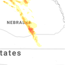


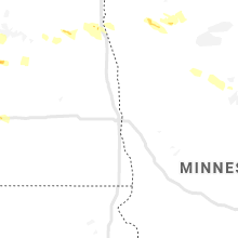


Cities Most Affected by Hail Storms of 8/6/2019
| Hail Size | Demographics of Zip Codes Affected | ||||||
|---|---|---|---|---|---|---|---|
| City | Count | Average | Largest | Pop Density | House Value | Income | Age |
| Lower Brule, SD | 2 | 2.75 | 2.75 | 1 | $44k | $20.4k | 22.7 |
| Blunt, SD | 2 | 2.25 | 2.75 | 1 | $37k | $32.5k | 46.0 |
| Chamberlain, SD | 2 | 1.88 | 2.00 | 10 | $74k | $33.9k | 42.0 |
| Harrold, SD | 1 | 3.00 | 3.00 | 1 | $33k | $24.4k | 42.7 |
| Java, SD | 1 | 2.75 | 2.75 | 1 | $11k | $28.5k | 49.3 |
| Gregory, SD | 1 | 2.75 | 2.75 | 4 | $39k | $24.8k | 49.2 |
| Beulah, ND | 1 | 2.00 | 2.00 | 10 | $66k | $43.3k | 45.6 |
| Atkinson, NE | 1 | 2.00 | 2.00 | 2 | $52k | $30.6k | 47.1 |
| Platte, SD | 1 | 2.00 | 2.00 | 3 | $60k | $30.6k | 45.1 |
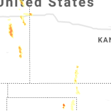
| Halstead, KS | 1 | 1.75 | 1.75 | 36 | $74k | $42.8k | 40.3 |
| Strasburg, ND | 1 | 1.75 | 1.75 | 1 | $37k | $26.4k | 53.2 |
| Hague, ND | 1 | 1.75 | 1.75 | 1 | $16k | $24.6k | 44.5 |
| Galatia, IL | 1 | 1.75 | 1.75 | 31 | $46k | $29.6k | 42.5 |
| Onida, SD | 1 | 1.75 | 1.75 | 1 | $56k | $35.2k | 43.7 |
| Chaffee, MO | 1 | 1.75 | 1.75 | 57 | $56k | $29.2k | 38.9 |
| Hartford, KY | 1 | 1.75 | 1.75 | 50 | $58k | $27.1k | 39.9 |
| Sterling, ND | 1 | 1.75 | 1.75 | 2 | $63k | $38.8k | 48.5 |
| Mc Leansboro, IL | 1 | 1.75 | 1.75 | 27 | $48k | $28.6k | 42.5 |
| Gettysburg, SD | 1 | 1.75 | 1.75 | 3 | $45k | $31.2k | 49.2 |
Hail and Wind Damage Spotted on 8/6/2019
Filter by Report Type:Hail ReportsWind Reports
States Impacted
Iowa, Ohio, Pennsylvania, New York, New Jersey, Arkansas, Missouri, Florida, North Dakota, Kansas, Illinois, Indiana, South Dakota, Maryland, Kentucky, West Virginia, Utah, District of Columbia, Tennessee, NebraskaIowa
| Local Time | Report Details |
|---|---|
| 7:26 AM CDT | Estimated from a personal weather station... lines up with other tree damage reports nearb in worth county IA, 12.2 miles NW of Mason City, IA |
Ohio
| Local Time | Report Details |
|---|---|
| 11:23 AM EDT | Tree down on hous in sandusky county OH, 87.2 miles W of Cleveland, OH |
| 12:12 PM EDT | Tree down across route in erie county OH, 51.4 miles W of Cleveland, OH |
| 12:45 PM EDT | Numerous trees dow in seneca county OH, 85.4 miles NNW of Columbus, OH |
| 1:45 PM EDT | Multiple trees down throughout pepper pik in cuyahoga county OH, 12.1 miles E of Cleveland, OH |
| 1:48 PM EDT | Large limbs and some trees dow in cuyahoga county OH, 11.1 miles E of Cleveland, OH |
| 2:13 PM EDT | Tree down on power line... snapped utility pol in huron county OH, 50.7 miles WSW of Cleveland, OH |
| 2:24 PM EDT | Tree fell on county sheriff vehicl in huron county OH, 51.7 miles WSW of Cleveland, OH |
| 2:24 PM EDT | Tree and limbs dow in huron county OH, 51.4 miles WSW of Cleveland, OH |
| 2:31 PM EDT | Tree dow in huron county OH, 51.4 miles WSW of Cleveland, OH |
| 2:45 PM EDT | Power lines knocked down onto utility pole... causing brief fir in erie county OH, 54.1 miles W of Cleveland, OH |
| 2:45 PM EDT | Corrects previous tstm wnd dmg report from 1 sw sandusky. utility pole struck by lighting... causing fire... not by storm damage. ----- power lines knocked down onto ut in erie county OH, 54.1 miles W of Cleveland, OH |
| 2:50 PM EDT | Trees and wires down throughout the cit in trumbull county OH, 48.8 miles ESE of Cleveland, OH |
| 2:51 PM EDT | Multiple trees dow in huron county OH, 51.2 miles WSW of Cleveland, OH |
| 2:51 PM EDT | Multiple trees and large limbs down... tents blown over in and around courthouse squar in trumbull county OH, 48.8 miles ESE of Cleveland, OH |
| 2:57 PM EDT | Six big limbs down. time estimated from rada in greene county OH, 47.1 miles NE of Cincinnati, OH |
| 3:00 PM EDT | Tree down on roa in lorain county OH, 39.7 miles SW of Cleveland, OH |
| 3:06 PM EDT | One half of a tree down. time estimated from rada in clinton county OH, 38 miles NE of Cincinnati, OH |
| 3:09 PM EDT | Tree down over power line. time estimated from rada in clinton county OH, 38.9 miles NE of Cincinnati, OH |
| 3:10 PM EDT | Tree down. time estimated from rada in clinton county OH, 39.7 miles NE of Cincinnati, OH |
| 3:55 PM EDT | Tree down. time estimated from rada in madison county OH, 21.9 miles SW of Columbus, OH |
| 4:14 PM EDT | Tree down on 303 and coit road... blocking the roa in portage county OH, 28.5 miles SE of Cleveland, OH |
| 4:23 PM EDT | Tree branch down on power pole... causing fir in portage county OH, 33.3 miles SE of Cleveland, OH |
| 5:40 PM EDT | Tree damage observed by law enforcement and the publi in huron county OH, 48.1 miles WSW of Cleveland, OH |
| 6:14 PM EDT | Report of a tree down in walnut creek townshi in holmes county OH, 68.1 miles S of Cleveland, OH |
| 6:22 PM EDT | Tree down on a house involving power line in holmes county OH, 66.9 miles S of Cleveland, OH |
| 8:51 PM EDT | Wind damage to shed and deck... along with missing shingles from roof. several downed tree in tuscarawas county OH, 79.3 miles W of Pittsburgh, PA |
Pennsylvania
| Local Time | Report Details |
|---|---|
| 12:49 PM EDT | Downed tree into wires near where stenton ave passes under the pennsylvania turnpike. time estimated from rada in montgomery county PA, 77.3 miles WSW of Brooklyn, NY |
| 2:57 PM EDT | A downed tree closed route 191 between monomonock rd and playhouse ln. large limbs were reported down elsewhere in mountainhome including one that fell onto and damaged in monroe county PA, 25.8 miles SE of Scranton, PA |
| 3:10 PM EDT | Multiple trees dow in erie county PA, 76.9 miles ENE of Cleveland, OH |
| 4:30 PM EDT | Large tree branch down blocking roa in erie county PA, 74.8 miles SW of Buffalo, NY |
| 6:53 PM EDT | Trees and wires down in duncansville and altoona in blair county PA, 39.1 miles SW of State College, PA |
| 7:46 PM EDT | Tree onto wires and on fire on foul rift road. time estimated from rada in warren county NJ, 50.7 miles SE of Scranton, PA |
New York
| Local Time | Report Details |
|---|---|
| 1:20 PM EDT | Trees blown down on latta roa in monroe county NY, 68.5 miles ENE of Buffalo, NY |
| 1:21 PM EDT | Large trees blown down on east ave in rochester. one fell on a structur in monroe county NY, 67.8 miles ENE of Buffalo, NY |
| 3:15 PM EDT | Tree down on rte 30 in schoharie county NY, 20.5 miles WSW of Schenectady, NY |
| 5:00 PM EDT | Downed tre in herkimer county NY, 55.9 miles ENE of Syracuse, NY |
| 5:50 PM EDT | Tree on wires in montgomery county NY, 39.9 miles WNW of Schenectady, NY |
| 5:58 PM EDT | Trees and wires dow in montgomery county NY, 32.8 miles WNW of Schenectady, NY |
| 6:21 PM EDT | Tree on wires in fulton county NY, 25.8 miles WNW of Schenectady, NY |
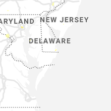
New Jersey
| Local Time | Report Details |
|---|---|
| 2:08 PM EDT | Downed tree on nj-50 in both directions south of gibson creek rd. all lanes were closed. time estimated from rada in atlantic county NJ, 72.2 miles NNE of Ocean City, MD |
| 7:40 PM EDT | Tree down into the roadway near 312 water street. time estimated from rada in warren county NJ, 50.2 miles SE of Scranton, PA |
| 7:42 PM EDT | Several trees reported down in belvidere. time estimated from rada in warren county NJ, 50.8 miles SE of Scranton, PA |
| 7:50 PM EDT | Trees down onto wires and on fire. time estimated from rada in warren county NJ, 52 miles SE of Scranton, PA |
| 8:10 PM EDT | Tree down across the roadway at brass castle road and fox chase road. time estimated from rada in warren county NJ, 54.3 miles SE of Scranton, PA |
Arkansas
| Local Time | Report Details |
|---|---|
| 2:29 PM CDT | Semi truck blown over on interstate 555 near the commerce drive exi in craighead county AR, 55.2 miles NW of Memphis, TN |
| 7:55 PM CDT | Storm damage reported in clay county AR, 87.3 miles SW of Cape Girardeau, MO |
| 8:00 PM CDT | Trees and powerlines down in the community of cornin in clay county AR, 84.5 miles SW of Cape Girardeau, MO |
| 8:45 PM CDT | Large tree limbs down in paragoul in greene county AR, 67.9 miles NNW of Memphis, TN |
| 9:29 PM CDT | Semi truck blown over on interstate 555 near the commerce drive exit. corrected tim in craighead county AR, 55.2 miles NW of Memphis, TN |
| 9:35 PM CDT | Large tree down across county road 73 in craighead county AR, 61.9 miles NW of Memphis, TN |
Missouri
| Local Time | Report Details |
|---|---|
| 2:39 PM CDT | Large trees snapped. time estimated from radar. twitter repor in franklin county MO, 31.7 miles WSW of Saint Louis, MO |
| 2:40 PM CDT | Quarter sized hail reported near Pacific, MO, 31 miles WSW of Saint Louis, MO, via picture on facebook. |
| 2:46 PM CDT | Half Dollar sized hail reported near Villa Ridge, MO, 35.3 miles WSW of Saint Louis, MO, mping report. |
| 3:06 PM CDT | County dispatch reports two trees down across the roa in jefferson county MO, 35.4 miles SW of Saint Louis, MO |
| 3:23 PM CDT | Half Dollar sized hail reported near Potosi, MO, 42.1 miles NE of Salem, MO, quarter size hail increasing in size to near half dollar size during conversation. |
| 4:11 PM CDT | Quarter sized hail reported near Caledonia, MO, 42.8 miles ENE of Salem, MO |
| 4:53 PM CDT | 45-50 mph winds and 4 inch tree limb down. pea size hai in cape girardeau county MO, 12.5 miles WSW of Cape Girardeau, MO |
| 5:00 PM CDT | Golf Ball sized hail reported near Chaffee, MO, 12.9 miles WSW of Cape Girardeau, MO, reported near along hwy 25 near delta. |
Florida
| Local Time | Report Details |
|---|---|
| 3:39 PM EDT | Tree snapped at the hampton court apartments in mangonia park. reported via the snapchat ma in palm beach county FL, 39.8 miles SSE of Port Saint Lucie, FL |
North Dakota
| Local Time | Report Details |
|---|---|
| 1:40 PM MDT | Ping Pong Ball sized hail reported near Golden Valley, ND, 71.3 miles SSW of Minot, ND, lots of pea to quarter size hail... largest stone was the size of a walnut. |
| 1:40 PM MDT | Quarter sized hail reported near Hazen, ND, 51.9 miles NW of Bismarck, ND |
| 3:17 PM CDT | Estimated 60 to 70 mph winds. egg sized hail. portions of trees stripped of leaves. lots of crop damag in oliver county ND, 52.2 miles WNW of Bismarck, ND |
| 3:17 PM CDT | Hen Egg sized hail reported near Beulah, ND, 52.2 miles WNW of Bismarck, ND, 60 to 70 mph winds. portions of trees stripped of leaves. lots of crop damage. |
| 3:23 PM CDT | Quarter sized hail reported near Beulah, ND, 51.8 miles WNW of Bismarck, ND |
| 3:35 PM CDT | Quarter sized hail reported near Mandan, ND, 10.1 miles SW of Bismarck, ND, crop damage also reported. |
| 3:40 PM CDT | Quarter sized hail reported near Mandan, ND, 17.1 miles S of Bismarck, ND |
| 3:47 PM CDT | Ping Pong Ball sized hail reported near Center, ND, 30.3 miles NW of Bismarck, ND |
| 3:56 PM CDT | Quarter sized hail reported near Bismarck, ND, 4.9 miles ESE of Bismarck, ND, lasted until 4 pm cdt. |
| 4:04 PM CDT | Ping Pong Ball sized hail reported near Bismarck, ND, 5.3 miles ESE of Bismarck, ND |
| 4:05 PM CDT | Strong winds reported at mcdowell dam east of bismarc in burleigh county ND, 6.7 miles E of Bismarck, ND |
| 4:12 PM CDT | 4 west of harmon lak in morton county ND, 17.4 miles WNW of Bismarck, ND |
| 4:17 PM CDT | Quarter sized hail reported near Mandan, ND, 8.5 miles WNW of Bismarck, ND |
| 4:20 PM CDT | Quarter sized hail reported near Mandan, ND, 13.4 miles W of Bismarck, ND, heavy rain. |
| 4:25 PM CDT | Ping Pong Ball sized hail reported near Mandan, ND, 11.6 miles WNW of Bismarck, ND, far west mandan. |
| 4:30 PM CDT | Golf Ball sized hail reported near Sterling, ND, 23.2 miles E of Bismarck, ND, quarter size to golf ball size hail reported in sterling. large trees and power lines down. |
| 4:39 PM CDT | Measured wind gust at sterling nd dot sensor sit in burleigh county ND, 25.7 miles E of Bismarck, ND |
| 4:41 PM CDT | Quarter sized hai in burleigh county ND, 2.6 miles SSE of Bismarck, ND |
| 4:41 PM CDT | Quarter sized hail reported near Bismarck, ND, 2.6 miles SSE of Bismarck, ND, 72 mph wind gust. |
| 5:34 PM CDT | Spotter estimated wind gusts up to 60 mph. trees with 6 inch diameter trunks were being bent close to the ground... but not breaking. accompanied by hail up to one-half in stutsman county ND, 66.3 miles E of Bismarck, ND |
| 5:45 PM CDT | Golf Ball sized hail reported near Strasburg, ND, 54.6 miles SSE of Bismarck, ND, public report relayed by social media. time estimated by radar. |
| 5:45 PM CDT | Picture shows large tree snapped. time estimated by radar. relayed by medi in stutsman county ND, 70.3 miles E of Bismarck, ND |
| 5:46 PM CDT | Golf Ball sized hail reported near Hague, ND, 58.6 miles SSE of Bismarck, ND, still hailing at time of report. no estimate on wind speed... just that it was very bad. |
| 5:53 PM CDT | Picture shows a large tree snapped. tree then fell on pickup. time estimated by radar. relayed by medi in stutsman county ND, 78.8 miles E of Bismarck, ND |
| 5:57 PM CDT | Measured wind gust at the north dakota agricultural weather network observation sit in stutsman county ND, 83.1 miles S of Devils Lake, ND |
| 6:49 PM CDT | Quarter sized hail reported near Fessenden, ND, 48.1 miles SW of Devils Lake, ND, lots of penny size hail with largest hail size up to a quarter. |
| 6:53 PM CDT | Quarter sized hail reported near Fessenden, ND, 44.4 miles SW of Devils Lake, ND |
| 7:16 PM CDT | Half Dollar sized hail reported near New Rockford, ND, 32.6 miles SSW of Devils Lake, ND, quarter to half dollar sized hail |
Kansas
| Local Time | Report Details |
|---|---|
| 3:15 PM CDT | Golf Ball sized hail reported near Halstead, KS, 23.6 miles NNW of Wichita, KS, delayed report received via facebook...hail the size of quarters to golf balls damaged car windows in halstead. |
| 3:19 PM CDT | Quarter sized hail reported near Halstead, KS, 23.6 miles NNW of Wichita, KS, quarter size hail and winds up to around 50mph in town halstead |
| 3:20 PM CDT | Delayed report received via facebook...tree branches down and penny size hail in harvey county KS, 23.6 miles NNW of Wichita, KS |
| 3:29 PM CDT | Power lines down... tree damage... and damage to railroad crossing gates in halstead due to severe wind in harvey county KS, 23.6 miles NNW of Wichita, KS |
| 3:30 PM CDT | Quarter sized hail reported near Halstead, KS, 23.6 miles NNW of Wichita, KS, photo received via twitter of quarter size hail and a large portion of a tree down in halstead. |
| 4:30 PM CDT | Pea size hail accompanied the win in sedgwick county KS, 16.9 miles WSW of Wichita, KS |
| 4:32 PM CDT | Delayed report. power pole snapped at base and damage to a barn roof. the damage occurred in the area of 71st and 247th street north of viola. report via twitte in sedgwick county KS, 18.4 miles WSW of Wichita, KS |
| 4:52 PM CDT | Tree down on k-42 at mile marker 71. time estimated based on rada in sumner county KS, 24.1 miles SW of Wichita, KS |
| 5:20 PM CDT | Numerous powerlines and telephone poles down across the western part of the count in bourbon county KS, 29.6 miles ENE of Chanute, KS |
| 5:30 PM MDT | Quarter sized hail reported near Kanorado, KS, 50.1 miles W of Colby, KS, time approximated from radar. hail ranged in size from pea to quarters. via facebook. |
| 6:35 PM CDT | Quarter sized hail reported near Minneola, KS, 59.7 miles SE of Garden City, KS |
| 6:36 PM CDT | Delayed report. tree branches down on the east side of chanute near 9th and ashby. time estimated based on rada in neosho county KS, 1.1 miles SE of Chanute, KS |
| 6:40 PM CDT | Social media report of large tree branches down in wei in cherokee county KS, 45.4 miles SE of Chanute, KS |
| 6:44 PM CDT | Social media report of large tree and branches down in scammo in cherokee county KS, 44.4 miles SE of Chanute, KS |
| 6:48 PM CDT | Delayed report. billboard sign blown over along hwy 39 east of chanute. time estimated based on rada in neosho county KS, 2.3 miles E of Chanute, KS |
| 7:00 PM CDT | Numerous large tree limbs down in tow in cherokee county KS, 48.8 miles SE of Chanute, KS |
Illinois
| Local Time | Report Details |
|---|---|
| 3:24 PM CDT | Golf Ball sized hail reported near Mc Leansboro, IL, 55 miles WNW of Evansville, IN, reported at il 242 and piopolis rd... about 6.5 miles north of mcleansboro. |
| 3:37 PM CDT | Power pole knocked down about 4.5 miles west southwest of fairfield in boylesto in wayne county IL, 54.5 miles WNW of Evansville, IN |
| 4:10 PM CDT | Golf Ball sized hail reported near Galatia, IL, 58.9 miles W of Evansville, IN |
| 4:20 PM CDT | Quarter sized hail reported near Eldorado, IL, 52.4 miles WSW of Evansville, IN, intermittent quarter size hail near eldorado reservoir. |
| 4:25 PM CDT | Quarter sized hail reported near Salem, IL, 66.6 miles SSW of Mattoon, IL, several reports of one inch hail around town. via facebook post with picture. |
| 4:25 PM CDT | Delayed report. trees limbs down around white county. time estimate in white county IL, 34 miles WNW of Evansville, IN |
| 5:54 PM CDT | Couple tree limbs down. one large enough to require backhoe to mov in hardin county IL, 48.2 miles SW of Evansville, IN |
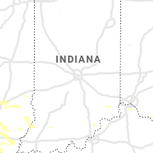
Indiana
| Local Time | Report Details |
|---|---|
| 4:31 PM EDT | Quarter sized hail reported near New Washington, IN, 41.4 miles NNE of Louisville, KY |
South Dakota
| Local Time | Report Details |
|---|---|
| 3:00 PM MDT | Brief hail between nickel and quarter siz in corson county SD, 79 miles SSW of Bismarck, ND |
| 3:25 PM MDT | Quarter sized hail reported near Mc Laughlin, SD, 80.1 miles S of Bismarck, ND, most hailstones between nickel and quarter size. |
| 3:45 PM MDT | Quarter sized hail reported near Mc Laughlin, SD, 81.9 miles S of Bismarck, ND, ground became white with hail. |
| 4:00 PM MDT | Quarter sized hail reported near Trail City, SD, 81.6 miles NNW of Pierre, SD, depth of hail was 5 inches. corn crop was stripped. |
| 4:04 PM MDT | Storm damage reported in dewey county SD, 79.3 miles NNW of Pierre, SD |
| 4:24 PM MDT | Quarter sized hail reported near Trail City, SD, 77.9 miles N of Pierre, SD, 40 mph wind estimate. corn crop was stripped. |
| 6:23 PM CDT | 1.75 inch hail also reporte in potter county SD, 47.2 miles N of Pierre, SD |
| 6:35 PM CDT | 3 inch diameter branch down. a few quarter size hail... but mostly dime to nickel siz in campbell county SD, 74.2 miles WNW of Aberdeen, SD |
| 6:39 PM CDT | Golf Ball sized hail reported near Gettysburg, SD, 38.1 miles NNE of Pierre, SD, all windows on north side of house broken out. |
| 6:43 PM CDT | Garden crops damaged and some flattene in campbell county SD, 71.1 miles WNW of Aberdeen, SD |
| 6:43 PM CDT | Golf Ball sized hail reported near Onida, SD, 32 miles NNE of Pierre, SD, 18 inch diameter tree down on power lines. |
| 7:18 PM CDT | Quarter sized hail reported near Selby, SD, 73.2 miles W of Aberdeen, SD, over 60 mph estimated as well. |
| 7:20 PM CDT | Also measured 2.4 inch hail 20 minutes after it fel in hughes county SD, 19.4 miles ENE of Pierre, SD |
| 7:21 PM CDT | Baseball sized hail reported near Blunt, SD, 21.5 miles ENE of Pierre, SD, golf ball to baseball sized hail fell from 1 mile west to 1 mile east of blunt. several reports of windows and siding broken. tree limbs down. winds estimated 60 to 65 |
| 7:28 PM CDT | Quarter sized hail reported near Java, SD, 67.7 miles W of Aberdeen, SD, mostly dime to nickel size hail with some quarter size. |
| 7:30 PM CDT | Baseball sized hail reported near Java, SD, 67.7 miles W of Aberdeen, SD, mostly golf ball size hail. vehicle windows shattered. |
| 7:33 PM CDT | Storm damage reported in walworth county SD, 67.7 miles W of Aberdeen, SD |
| 7:40 PM CDT | Quarter sized hail reported near Bowdle, SD, 62.8 miles W of Aberdeen, SD, time estimated from radar. |
| 7:48 PM CDT | Tea Cup sized hail reported near Harrold, SD, 29.1 miles ESE of Pierre, SD, many hail stones exceeding 3 inches in size. |
| 7:50 PM CDT | Half Dollar sized hail reported near Hoven, SD, 62.4 miles WSW of Aberdeen, SD, mostly quarter size hail... some half dollar size. some garden crop damage. |
| 8:05 PM CDT | Baseball sized hail reported near Lower Brule, SD, 35.9 miles ESE of Pierre, SD, mostly golf ball size hail with a few baseball size. |
| 8:10 PM CDT | Quarter sized hail reported near Onaka, SD, 55.5 miles WSW of Aberdeen, SD |
| 8:20 PM CDT | Golf Ball sized hail reported near Blunt, SD, 21.5 miles ENE of Pierre, SD |
| 8:28 PM CDT | Half Dollar sized hail reported near Harrold, SD, 25 miles ENE of Pierre, SD, quarter to half dollar size. no apparent damage noticeable. |
| 8:45 PM CDT | Dot rwi in lyman county SD, 53.2 miles SE of Pierre, SD |
| 8:57 PM CDT | Quarter sized hail reported near Chamberlain, SD, 66.5 miles SE of Pierre, SD, hail stones have been increasing in size over the past 5 minutes. |
| 8:57 PM CDT | Quarter sized hail reported near Chamberlain, SD, 66.4 miles SE of Pierre, SD |
| 9:00 PM CDT | Quarter sized hail reported near Chamberlain, SD, 66.5 miles SE of Pierre, SD, hail stones have been increasing in size over the past 5 minutes. |
| 9:05 PM CDT | Quarter sized hail reported near Harrold, SD, 30.3 miles ESE of Pierre, SD |
| 9:15 PM CDT | Hen Egg sized hail reported near Chamberlain, SD, 66.5 miles SE of Pierre, SD |
| 9:15 PM CDT | Hen Egg sized hail reported near Platte, SD, 60.1 miles NNW of Oneill, NE |
| 9:15 PM CDT | Baseball sized hail reported near Lower Brule, SD, 43.4 miles ESE of Pierre, SD, tennis ball to baseball size hail. window damage to vehicles and homes. |
| 9:15 PM CDT | Storm damage reported in lyman county SD, 43.4 miles ESE of Pierre, SD |
| 9:28 PM CDT | Quarter sized hail reported near Platte, SD, 77.9 miles NNW of Oneill, NE |
| 9:54 PM CDT | Golf Ball sized hail reported near Chamberlain, SD, 67.2 miles SE of Pierre, SD, nickel up to golf ball sized hail fell. |
| 10:10 PM CDT | Baseball sized hail reported near Gregory, SD, 70 miles NE of Valentine, NE, hail destroyed windshield and headlights. no injuries. report relayed via spotter who came across the disabled vehicle and occupants. |
| 10:30 PM CDT | At least six large pine... spruce... and cedar trees down in yar in gregory county SD, 59.6 miles NNW of Oneill, NE |
| 10:30 PM CDT | Building debris scattered across the highwa in gregory county SD, 59.8 miles NNW of Oneill, NE |
Maryland
| Local Time | Report Details |
|---|---|
| 5:50 PM EDT | Quarter sized hail reported near Baltimore, MD, 1.2 miles ENE of Baltimore, MD, quarter sized hail |
| 6:25 PM EDT | Numerous reports of tree damage across the southern and eastern portions of baltimore city in baltimore city county MD, 1.1 miles E of Baltimore, MD |
| 6:25 PM EDT | Storm damage reported in baltimore city county MD, 0.7 miles S of Baltimore, MD |
| 6:42 PM EDT | Storm damage reported in anz538 county MD, 2.1 miles SE of Baltimore, MD |
| 6:49 PM EDT | Personal weather station near patterson park in baltimore city county MD, 1.6 miles E of Baltimore, MD |
| 7:09 PM EDT | Trees down on glen road in travilah in montgomery county MD, 37.4 miles WSW of Baltimore, MD |
| 7:12 PM EDT | Trees down on glen road in travilah. corrected event tim in montgomery county MD, 37.4 miles WSW of Baltimore, MD |
| 7:16 PM EDT | Tree down blocking all lanes of md-190 river road just east of md-191 bradley boulevar in montgomery county MD, 36.6 miles WSW of Baltimore, MD |
| 7:20 PM EDT | Wires down at the intersection of clewerwall drive and river road in montgomery county MD, 36.2 miles WSW of Baltimore, MD |
| 7:25 PM EDT | Tree down blocking seven locks road just north of bradley boulevard in montgomery county MD, 35.3 miles WSW of Baltimore, MD |
| 7:48 PM EDT | Numerous trees reported down throughout bethesda in montgomery county MD, 34.4 miles SW of Baltimore, MD |
| 7:50 PM EDT | A couple trees and several large limbs down along i-495 capital beltway outer loop near i-270 western spur (on the shoulder in montgomery county MD, 35.3 miles SW of Baltimore, MD |
| 8:02 PM EDT | Numerous trees reported down throughout chevy chase in montgomery county MD, 32.3 miles SW of Baltimore, MD |
| 8:06 PM EDT | Numerous trees reported down throughout chevy chase. corrected event tim in montgomery county MD, 32.3 miles SW of Baltimore, MD |
| 8:30 PM EDT | Wires down on 54th plac in prince georges county MD, 29.4 miles SW of Baltimore, MD |
Kentucky
| Local Time | Report Details |
|---|---|
| 4:52 PM CDT | Tree limb down along 3rd st. in uniontow in union county KY, 25 miles SW of Evansville, IN |
| 4:57 PM CDT | Trees in robards just west of 41s on highway 41 in henderson county KY, 19.8 miles S of Evansville, IN |
| 5:18 PM CDT | Tree limb down... blocked state route 14 in union county KY, 31.8 miles SSW of Evansville, IN |
| 5:20 PM CDT | Tree limb down blocked poplar ridge r in union county KY, 36.2 miles SSW of Evansville, IN |
| 5:21 PM CDT | Golf Ball sized hail reported near Hartford, KY, 49.5 miles SE of Evansville, IN, time estimate by radar. |
| 5:22 PM CDT | Trees down near state route 1245 in beaver da in ohio county KY, 54.7 miles SE of Evansville, IN |
| 5:52 PM CDT | Large limbs down... some of which damaged vehicles. (media relayed report in crittenden county KY, 52.9 miles SW of Evansville, IN |
| 5:58 PM CDT | Several tree limbs down in nebo. time estimate in hopkins county KY, 40.7 miles S of Evansville, IN |
| 6:02 PM CDT | Tree down along state route 166 in crittenden county KY, 53.1 miles SW of Evansville, IN |
| 6:11 PM CDT | Large tree limbs down around madisonville. time estimate in hopkins county KY, 44 miles S of Evansville, IN |
| 6:21 PM CDT | Large tree limbs down around nortonville. time estimate in hopkins county KY, 54.6 miles S of Evansville, IN |
| 7:03 PM CDT | Trees down on trailer at yoakum circle off highway 10 in christian county KY, 59 miles NW of Nashville, TN |
| 7:40 PM CDT | Tree down along watermelon roa in logan county KY, 39.9 miles NNW of Nashville, TN |
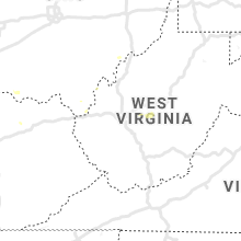
West Virginia
| Local Time | Report Details |
|---|---|
| 7:25 PM EDT | Tree down on warm springs road near intersection with shenandoah junction roa in jefferson county WV, 66.6 miles W of Baltimore, MD |
Utah
| Local Time | Report Details |
|---|---|
| 5:53 PM MDT | Asos station kcny canyonlands field airpor in grand county UT, 67.2 miles WSW of Grand Junction, CO |
District of Columbia
| Local Time | Report Details |
|---|---|
| 7:58 PM EDT | Tree down in 3200 block of aberfoyle place n in district of columb county DC, 32.3 miles SW of Baltimore, MD |
| 8:32 PM EDT | Tree down on 16th street nw near intersection with floral street nw. corrected event tim in district of columb county DC, 31.5 miles SW of Baltimore, MD |
| 9:02 PM EDT | Tree down on 16th street nw near intersection with floral street n in district of columb county DC, 31.5 miles SW of Baltimore, MD |
Tennessee
| Local Time | Report Details |
|---|---|
| 7:55 PM CDT | Storm damage reported in robertson county TN, 23 miles N of Nashville, TN |
| 8:05 PM CDT | Storm damage reported in robertson county TN, 17.4 miles N of Nashville, TN |
| 8:21 PM CDT | Trees down in davidson county TN, 9.3 miles NE of Nashville, TN |
| 8:26 PM CDT | Tree down across graylynn drive in davidson county TN, 5.5 miles E of Nashville, TN |
| 8:30 PM CDT | Tree on car in davidson county TN, 6.1 miles E of Nashville, TN |
| 8:37 PM CDT | Tree down in sylvan park in davidson county TN, 2.3 miles W of Nashville, TN |
| 8:50 PM CDT | Trees down at nolensville rd and pettus rd in williamson county TN, 13.7 miles S of Nashville, TN |
| 9:10 PM CDT | Powerlines and several large tree limbs down on millsfield highway near cloverdale. time estimate in obion county TN, 47.4 miles W of Mc Kenzie, TN |
| 9:47 PM CDT | Storm damage reported in bedford county TN, 56.2 miles SSE of Nashville, TN |
Nebraska
| Local Time | Report Details |
|---|---|
| 11:03 PM CDT | Hen Egg sized hail reported near Atkinson, NE, 30.6 miles NW of Oneill, NE, report via social media with picture. |
| 11:40 PM CDT | Report of tree and powerlines down along highway near emmet in holt county NE, 8.4 miles W of Oneill, NE |
| 12:02 AM CDT | Storm damage reported in holt county NE, 0.2 miles NNW of Oneill, NE |
| 1:21 AM CDT | Storm damage reported in wheeler county NE, 43.8 miles S of Oneill, NE |
| 1:31 AM CDT | Storm damage reported in valley county NE, 57.5 miles NNW of Grand Island, NE |
| 2:30 AM CDT | Also had pea sized hai in hall county NE, 15.1 miles WNW of Grand Island, NE |
| 2:42 AM CDT | Storm damage reported in hall county NE, 9.9 miles WSW of Grand Island, NE |
| 2:49 AM CDT | Storm damage reported in hall county NE, 3.5 miles NNE of Grand Island, NE |
| 2:54 AM CDT | Storm damage reported in hall county NE, 10.7 miles S of Grand Island, NE |
Connect with Interactive Hail Maps