

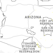
Hail Map for Tuesday, August 8, 2023

Number of Impacted Households on 8/8/2023
0
Impacted by 1" or Larger Hail
0
Impacted by 1.75" or Larger Hail
0
Impacted by 2.5" or Larger Hail
Square Miles of Populated Area Impacted on 8/8/2023
0
Impacted by 1" or Larger Hail
0
Impacted by 1.75" or Larger Hail
0
Impacted by 2.5" or Larger Hail


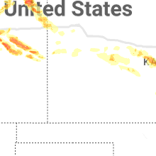


Cities Most Affected by Hail Storms of 8/8/2023
| Hail Size | Demographics of Zip Codes Affected | ||||||
|---|---|---|---|---|---|---|---|
| City | Count | Average | Largest | Pop Density | House Value | Income | Age |
| Yuma, CO | 9 | 2.69 | 4.00 | 7 | $84k | $32.3k | 37.1 |
| Otis, CO | 4 | 2.50 | 3.00 | 2 | $61k | $35.5k | 43.9 |
| Idalia, CO | 2 | 5.00 | 5.00 | 1 | $119k | $36.3k | 34.9 |
| Gordon, NE | 4 | 1.94 | 2.50 | 2 | $46k | $28.0k | 45.1 |
| Sterling, CO | 2 | 2.88 | 4.00 | 31 | $91k | $32.2k | 37.3 |
| Hugo, CO | 2 | 2.13 | 2.50 | 0 | $71k | $31.3k | 46.8 |
| Hawley, MN | 1 | 2.00 | 2.00 | 14 | $82k | $42.4k | 38.7 |
| Elizabeth, CO | 1 | 1.75 | 1.75 | 66 | $220k | $67.6k | 43.1 |
Hail and Wind Damage Spotted on 8/8/2023
Filter by Report Type:Hail ReportsWind Reports
States Impacted
Arizona, South Carolina, Georgia, Massachusetts, Alabama, Minnesota, Wyoming, Nebraska, Colorado, South Dakota, Texas, Oklahoma, KansasArizona
| Local Time | Report Details |
|---|---|
| 6:05 AM MST | 2 uprooted trees with trunks of 6 to 8 inch diameter. winds estimated at 50-60 mp in maricopa county AZ, 18.1 miles ESE of Phoenix, AZ |
| 4:00 PM MST | Power poles knocked down at n anway rd and n tucker r in pima county AZ, 22.6 miles WNW of Tucson, AZ |
South Carolina
| Local Time | Report Details |
|---|---|
| 9:26 AM EDT | Recorded by kmyr awos in horry county SC, 68.2 miles SW of Wilmington, NC |
| 8:03 PM EDT | Tree reported down on cooks landing road. time estimated from rada in jasper county SC, 9 miles NNE of Savannah, GA |
| 8:03 PM EDT | Tree reported down on bellinger hill and zig zag road. time estimated from rada in jasper county SC, 6.3 miles NE of Savannah, GA |
| 8:19 PM EDT | One tree reported down on ebenezer road. time estimated from rada in effingham county GA, 21.3 miles NNW of Savannah, GA |
| 8:24 PM EDT | Jasper county dispatch reported a tree down near the intersection of moorer avenue and burke stree in jasper county SC, 13.1 miles N of Savannah, GA |
| 8:26 PM EDT | Jasper county dispatch reported a tree down near the intersection of deerfield road and old charleston highwa in jasper county SC, 17.9 miles N of Savannah, GA |
| 8:28 PM EDT | Jasper county dispatch reported a tree down near the intersection of deerfield road and deer lan in jasper county SC, 16.5 miles N of Savannah, GA |
| 8:31 PM EDT | Tree down on paynesville and deerfield road. time estimated from rada in jasper county SC, 13.7 miles N of Savannah, GA |
| 8:35 PM EDT | A 911 call center reported a tree down along innovation dr. time was estimated via radar dat in beaufort county SC, 15.9 miles NE of Savannah, GA |
| 8:39 PM EDT | Tree down reported on great swamp road. time estimated from rada in jasper county SC, 28.6 miles N of Savannah, GA |
| 8:41 PM EDT | Jasper county dispatch reported a tree down in the 1500 block of grays highway near the ridgeland airport due to thunderstorm outflo in jasper county SC, 29.5 miles NNE of Savannah, GA |
| 8:41 PM EDT | A 911 call center reported a tree down along waterford dr. time was estimated via radar dat in beaufort county SC, 19.2 miles NE of Savannah, GA |
| 9:03 PM EDT | A 911 call center reported a tree down along new riverside rd. time was estimated via radar dat in beaufort county SC, 13 miles NE of Savannah, GA |
| 10:03 PM EDT | Emergency manager reported a tree down along 3500 bonnie doon rd. time was estimated via radar dat in colleton county SC, 43.3 miles SW of Charleston, SC |
Georgia
| Local Time | Report Details |
|---|---|
| 10:07 AM EDT | Tree dow in fayette county GA, 27.5 miles SSW of Atlanta, GA |
| 4:19 PM EDT | A tree was reported down across thompson r in upson county GA, 53 miles S of Atlanta, GA |
| 4:20 PM EDT | Tree blocking both lanes of thompson r in upson county GA, 53 miles S of Atlanta, GA |
| 4:25 PM EDT | 2 trees down on winding way road. time estimated by rada in quitman county GA, 55.9 miles SSE of Auburn, AL |
| 4:40 PM EDT | A tree fell onto power lines on school ave at 2nd s in dooly county GA, 73.8 miles NW of Douglas, GA |
| 4:45 PM EDT | Multiple trees were reported down across webster county including a number of roads that were impassable... all north of hwy 28 in webster county GA, 65.4 miles ESE of Auburn, AL |
| 4:45 PM EDT | A tree fell onto a power line on murray farm rd and caused a fire in a wooded are in marion county GA, 57.1 miles ESE of Auburn, AL |
| 4:45 PM EDT | Numerous trees down across the count in randolph county GA, 70.5 miles SE of Auburn, AL |
| 5:00 PM EDT | Numerous trees down countywid in terrell county GA, 83.6 miles SE of Auburn, AL |
| 5:00 PM EDT | Trees and powerlines reported down throughout ellaville including: 57th block of n. stevens st. 465th block of n broad st. 39th block of bridges s in schley county GA, 73 miles ESE of Auburn, AL |
| 5:20 PM EDT | A couple trees down around leesburg. stop light blown from overhanging wire and impacted car. other stop light is still hanging from partially-downed wir in lee county GA, 79.4 miles WNW of Douglas, GA |
| 5:27 PM EDT | Quarter sized hail reported near Byron, GA, 84.1 miles SSE of Atlanta, GA |
| 5:30 PM EDT | Quarter sized hail reported near Centerville, GA, 87.7 miles SSE of Atlanta, GA, 1.00 hail reported near the intersection of gunn rd and us hwy 41. |
| 5:35 PM EDT | Trees were blown down at old dawson road/winifred roa in dougherty county GA, 81.3 miles N of Tallahassee, FL |
| 5:35 PM EDT | Trees knocked down destroying a wooden fenc in houston county GA, 87.1 miles NNW of Douglas, GA |
| 5:39 PM EDT | Numerous trees down countywid in worth county GA, 62.8 miles WNW of Douglas, GA |
| 5:40 PM EDT | Trees were blown down at nottingham way/whispering pines roa in dougherty county GA, 80 miles W of Douglas, GA |
| 5:45 PM EDT | Trees were blown down at the 1400 block of 11th avenu in dougherty county GA, 78.8 miles W of Douglas, GA |
| 5:50 PM EDT | Trees were blown down at oglethorpe boulevard/liberty expresswa in dougherty county GA, 74.5 miles W of Douglas, GA |
| 5:50 PM EDT | Numerous trees down countywid in dougherty county GA, 78.7 miles W of Douglas, GA |
| 5:50 PM EDT | Numerous trees down countywid in worth county GA, 58.5 miles W of Douglas, GA |
| 5:52 PM EDT | Trees and powerlines down on east crawford in colquit in miller county GA, 57 miles NNW of Tallahassee, FL |
| 5:52 PM EDT | Tree down on 91 south in baker county. time estimated by rada in baker county GA, 53.6 miles NNW of Tallahassee, FL |
| 5:59 PM EDT | Handheld anemometer measured 70 mph gus in tift county GA, 39.6 miles W of Douglas, GA |
| 6:00 PM EDT | Numerous trees down countywid in tift county GA, 39.2 miles W of Douglas, GA |
| 6:08 PM EDT | Trees down on mount olive church road. one tree fell on a school bus. no injurie in tift county GA, 35.5 miles W of Douglas, GA |
| 6:11 PM EDT | Trained spotter measured 60 mph gust on roof top anemomete in colquitt county GA, 57.2 miles WSW of Douglas, GA |
| 6:12 PM EDT | Trees were blown down along walker ave on the west side of fitzgeral in ben hill county GA, 29 miles WNW of Douglas, GA |
| 6:15 PM EDT | A pecan tree and power lines were blown down on west roanoke driv in ben hill county GA, 28 miles WNW of Douglas, GA |
| 6:20 PM EDT | Numerous trees down countywid in ben hill county GA, 27.8 miles WNW of Douglas, GA |
| 6:22 PM EDT | Large tree branches around 5 inches in diameter and one small tree were blown dow in colquitt county GA, 53.3 miles WSW of Douglas, GA |
| 6:25 PM EDT | Several trees down across the count in irwin county GA, 24.5 miles WNW of Douglas, GA |
| 6:26 PM EDT | A tree was reported down on a powerline along hwy 11 in telfair county GA, 22 miles NNW of Douglas, GA |
| 6:29 PM EDT | One tree down reported on hwy 292 and jack anderson r in tattnall county GA, 62 miles W of Savannah, GA |
| 6:32 PM EDT | One tree reported down on oak road and church road. time estimated from rada in tattnall county GA, 60.2 miles W of Savannah, GA |
| 6:33 PM EDT | Tree down in coolidge. time estimated by rada in thomas county GA, 46.3 miles NNE of Tallahassee, FL |
| 6:35 PM EDT | Trees were reported down all across coffee county. time was estimated by radar. more specific locations will be provided late in coffee county GA, 11.1 miles WNW of Douglas, GA |
| 6:40 PM EDT | Power pole down in pav in thomas county GA, 48.2 miles NE of Tallahassee, FL |
| 6:42 PM EDT | Tree down on mccranie road in spark in cook county GA, 41 miles WSW of Douglas, GA |
| 6:44 PM EDT | One tree reported down on hwy 144 and 178. time estimated from rada in tattnall county GA, 55.2 miles ENE of Douglas, GA |
| 6:45 PM EDT | Numerous trees down on the west side of berrien county. storms still moving across eastern half of the count in berrien county GA, 31.2 miles SW of Douglas, GA |
| 6:45 PM EDT | A tree was blown down onto a power line near coppage road and skipper bridge roa in lowndes county GA, 44.1 miles SW of Douglas, GA |
| 6:50 PM EDT | A tree was blown down onto a power line at 5100 fiveash roa in lowndes county GA, 47.5 miles SW of Douglas, GA |
| 6:50 PM EDT | Multiple reports of structural damage on the nw side of mt. vernon along mckinnon stree in montgomery county GA, 49.4 miles NNE of Douglas, GA |
| 7:02 PM EDT | Tree limbs and trees down near pearson. radar estimated tim in atkinson county GA, 8.7 miles S of Douglas, GA |
| 7:05 PM EDT | Numerous trees and power lines were blown down across the count in brooks county GA, 49.2 miles ENE of Tallahassee, FL |
| 7:13 PM EDT | A 911 call center reported two trees and a power line down along hwy 280... located near the cross streets of harvey rd as well as groveland nevils rd. time was estimed in bryan county GA, 38.9 miles W of Savannah, GA |
| 7:13 PM EDT | A 911 call center reported a tree down across the roadway near the 4900 block of hwy 280 w. time was estimated via radar dat in bryan county GA, 36.5 miles W of Savannah, GA |
| 7:13 PM EDT | Multiple trees down in cobbtown... g in tattnall county GA, 63 miles WNW of Savannah, GA |
| 7:13 PM EDT | Multiple trees reported down in collins... ga. time estimated from rada in tattnall county GA, 60.2 miles W of Savannah, GA |
| 7:13 PM EDT | Multiple trees reported down in reidsville... ga. time estimated from rada in tattnall county GA, 58.9 miles NE of Douglas, GA |
| 7:15 PM EDT | Asos station kamg alm in bacon county GA, 20.7 miles E of Douglas, GA |
| 7:16 PM EDT | A 911 call center reported a power line down across the railroad track near the 3300 block of hwy 280 w. time was estimated via radar dat in bryan county GA, 36.5 miles W of Savannah, GA |
| 7:22 PM EDT | Multiple trees reported down in bellville... ga. time estimated from rada in evans county GA, 51.8 miles W of Savannah, GA |
| 7:25 PM EDT | Metter airport gusted to 56 kts (64 mph). time updated from rada in candler county GA, 61.3 miles WNW of Savannah, GA |
| 7:28 PM EDT | 911 call center reported power line down at the intersection of porterfield and indian trail rd. time was estimated via radar dat in bryan county GA, 22.9 miles W of Savannah, GA |
| 7:29 PM EDT | Metter fire department chief reported multiple trees down across the town of mette in candler county GA, 60.9 miles WNW of Savannah, GA |
| 7:32 PM EDT | Multiple trees down reported in register... ga. time estimated from rada in bulloch county GA, 50.3 miles WNW of Savannah, GA |
| 7:33 PM EDT | A metal street sign was blown over at the intersection of peterson ave and ward street. time was estimated by rada in coffee county GA, 0.3 miles N of Douglas, GA |
| 7:35 PM EDT | Multiple trees reported down across claxton... ga. time estimated from rada in evans county GA, 47.8 miles W of Savannah, GA |
| 7:38 PM EDT | One tree reported down in hinesville... ga. time estimated from rada in liberty county GA, 35.1 miles WSW of Savannah, GA |
| 7:40 PM EDT | One tree uprooted on chevis road. time estimated from rada in chatham county GA, 11.7 miles WSW of Savannah, GA |
| 7:41 PM EDT | Multiple trees down reported in daisy... g in evans county GA, 44.2 miles W of Savannah, GA |
| 7:41 PM EDT | Tree reported down on abercorn street at gateway blvd. time estimated from rada in chatham county GA, 12.4 miles WSW of Savannah, GA |
| 7:42 PM EDT | Tree reported down on 600 block of railroad avenue in daisy... ga. time estimated from rada in evans county GA, 43.6 miles W of Savannah, GA |
| 7:44 PM EDT | Tree reported down on salt creek road. time estimated from rada in chatham county GA, 7 miles WSW of Savannah, GA |
| 7:45 PM EDT | Trees and powerlines down along high bluff road. report received via social media. time was estimated by rada in brantley county GA, 45.3 miles ESE of Douglas, GA |
| 7:46 PM EDT | Multiple trees down reported in brooklet... ga. time estimated from rada in bulloch county GA, 39.2 miles WNW of Savannah, GA |
| 7:46 PM EDT | Multiple trees reported down in arcola... ga. time estimated from rada in bulloch county GA, 34.8 miles WNW of Savannah, GA |
| 7:46 PM EDT | Multiple trees reported down in stilson... ga. time estimated from rada in bulloch county GA, 32.4 miles WNW of Savannah, GA |
| 7:46 PM EDT | Tree down on old louisville road. time estimated from rada in chatham county GA, 6.5 miles WNW of Savannah, GA |
| 7:46 PM EDT | Tree reported down on augusta road at crossgate road. time estimated from rada in chatham county GA, 7.1 miles NW of Savannah, GA |
| 7:50 PM EDT | Tree reported down on grove point road. time estimated from rada in chatham county GA, 6.9 miles SSW of Savannah, GA |
| 7:50 PM EDT | Tree reported down on grove point road. time estimated from rada in chatham county GA, 6.9 miles SSW of Savannah, GA |
| 7:55 PM EDT | Tree reported down on harlan dr. time estimated from rada in chatham county GA, 4.2 miles S of Savannah, GA |
| 7:57 PM EDT | Tree reported down on northgate rd. time estimated from rada in chatham county GA, 3.1 miles SSE of Savannah, GA |
| 7:58 PM EDT | Tree reported down on ferguson avenue at marvalingrove dr. time estimated from rada in chatham county GA, 7 miles S of Savannah, GA |
| 7:58 PM EDT | One tree reported down in midway... ga. time estimated from rada in liberty county GA, 27.3 miles SW of Savannah, GA |
| 8:05 PM EDT | *** 1 fatal *** chatham county police department and chatham county emergency management agency reported one fatality due to a tree falling on a vehicle in the 5600 blo in chatham county GA, 5 miles SSE of Savannah, GA |
| 8:09 PM EDT | One tree reported down on belle bluff road. time estimated from rada in mcintosh county GA, 39.2 miles SSW of Savannah, GA |
| 8:14 PM EDT | Tybee south weather flow (xtye) gusted to 62 mp in chatham county GA, 15.5 miles ESE of Savannah, GA |
| 8:15 PM EDT | Savannah entrance light weather flow (xsel) gusted to 65 mp in amz352 county GA, 17.2 miles ESE of Savannah, GA |
Massachusetts
| Local Time | Report Details |
|---|---|
| 10:25 AM EDT | Large tree and wires down on ashland stree in middlesex county MA, 26 miles N of Providence, RI |
| 11:20 AM EDT | Trees and wires down on north street around eldorado dr. relayed by amateur radi in plymouth county MA, 31.5 miles ESE of Providence, RI |
| 11:20 AM EDT | Trees and wires down on hereford hill rd. relayed by amateur radi in plymouth county MA, 30.7 miles ESE of Providence, RI |
| 11:20 AM EDT | Trees and wires down on hereford hill rd. relayed by amateur radi in plymouth county MA, 30.7 miles ESE of Providence, RI |
| 12:05 PM EDT | Several reports of trees and wires down and trees blocking the road on west barnstable road in osterville and on commerce road at main stree in barnstable county MA, 58.1 miles E of Providence, RI |
| 12:15 PM EDT | Tree down along rt 6 near exit 68. relayed by amateur radi in barnstable county MA, 56.2 miles E of Providence, RI |
| 12:51 PM EDT | Numerous trees down in the tinkham lane area as well as on acushnet road and stoney hill roa in plymouth county MA, 33.1 miles ESE of Providence, RI |
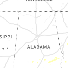
Alabama
| Local Time | Report Details |
|---|---|
| 1:49 PM CDT | Large tree limb down near the intersection of taylor road and east drive (near auburn university at montgomery). tree limb measured 8 inches in diamete in montgomery county AL, 43.4 miles WSW of Auburn, AL |
| 1:55 PM CDT | Several trees down across southern portions of montgomery county... a in montgomery county AL, 53.9 miles SW of Auburn, AL |
| 2:00 PM CDT | Trees and power lines down on ramer grady roa in montgomery county AL, 58.3 miles SW of Auburn, AL |
| 2:21 PM CDT | Multiple trees down along county road 7714 in northern pike county... a in pike county AL, 58 miles SSW of Auburn, AL |
| 2:35 PM CDT | Multiple trees down on highway 223 and on highway 2 in bullock county AL, 40.1 miles SSW of Auburn, AL |
| 2:55 PM CDT | Reports of multiple trees down between hurtsboro... al and pittsview... a in russell county AL, 30.5 miles SSE of Auburn, AL |
| 3:15 PM CDT | Coffee county dispatch reported downed powerlines on cr-12 in coffee county AL, 77 miles SSW of Auburn, AL |
| 3:19 PM CDT | Tree down on cr 69. time estimated by rada in dale county AL, 72.9 miles S of Auburn, AL |
| 3:21 PM CDT | Trees down on bluff creek road and patterson roa in russell county AL, 39.4 miles SE of Auburn, AL |
| 3:22 PM CDT | A tree was blown down onto county road 49 in coffee county AL, 59.4 miles NNE of Miramar Beach, FL |
| 3:29 PM CDT | Trees and powerlines down on west washington street and east washington stree in henry county AL, 72.8 miles S of Auburn, AL |
Minnesota
| Local Time | Report Details |
|---|---|
| 2:55 PM CDT | Quarter sized hail reported near Kabetogama, MN, 13.5 miles SE of International Falls, MN, mostly dime size hail with a few hailstones around quarter size. time approximate. storm started around two thirty pm and was ending around time of phone call around th |
| 3:10 PM CDT | Quarter sized hail reported near Kabetogama, MN, 20.9 miles SE of International Falls, MN, pea to quarter size hail. time estimated from radar. |
| 5:08 PM CDT | Hen Egg sized hail reported near Hawley, MN, 21.9 miles E of Fargo, ND, picture relayed by broadcast media. time estimated from radar. |
| 5:58 PM CDT | Spotter reports that a tree 12 to 14 inches in diameter was blown over. this tree then fell on a couple of power poles and broke them. time of wind damage estimated fro in st. louis county MN, 46.4 miles SE of International Falls, MN |
Wyoming
| Local Time | Report Details |
|---|---|
| 2:55 PM MDT | Quarter sized hail reported near Sheridan, WY, 83.2 miles WNW of Gillette, WY |
Nebraska
| Local Time | Report Details |
|---|---|
| 3:59 PM MDT | Quarter sized hail reported near Alliance, NE, 48.5 miles ENE of Scottsbluff, NE |
| 5:50 PM MDT | 50 to 60 mph wind gusts... blew several potted plants off of porc in garden county NE, 75.3 miles ESE of Scottsbluff, NE |
| 6:26 PM MDT | Tennis Ball sized hail reported near Gordon, NE, 83.9 miles W of Valentine, NE, golf ball to just smaller than baseball size hail. |
| 6:27 PM MDT | Golf Ball sized hail reported near Gordon, NE, 83.9 miles W of Valentine, NE, golfball sized hail. |
| 6:28 PM MDT | Golf Ball sized hail reported near Gordon, NE, 83.9 miles W of Valentine, NE, public reports golf ball sized hail. |
| 6:45 PM MDT | Golf Ball sized hail reported near Gordon, NE, 80.7 miles W of Valentine, NE, public reports 15 min period of golf ball sized hail with leaf damage on many trees in area. |
| 11:06 PM CDT | Storm damage reported in buffalo county NE, 49.7 miles WSW of Grand Island, NE |
| 11:10 PM CDT | Storm damage reported in buffalo county NE, 49.7 miles WSW of Grand Island, NE |
| 12:08 AM CDT | Personal weather statio in adams county NE, 21.1 miles S of Grand Island, NE |
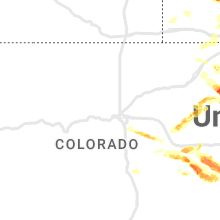
Colorado
| Local Time | Report Details |
|---|---|
| 4:08 PM MDT | Golf Ball sized hail reported near Otis, CO, 17.2 miles NW of Yuma, CO |
| 5:00 PM MDT | Pub state patro in washington county CO, 6.8 miles W of Yuma, CO |
| 5:00 PM MDT | Golf Ball sized hail reported near Yuma, CO, 4 miles NE of Yuma, CO, delayed report via social media. |
| 5:00 PM MDT | Baseball sized hail reported near Yuma, CO, 11.6 miles S of Yuma, CO, delayed report via social media with picture. time estimated. |
| 5:02 PM MDT | Tea Cup sized hail reported near Otis, CO, 5.7 miles W of Yuma, CO, de175. |
| 5:05 PM MDT | Hen Egg sized hail reported near Otis, CO, 6.2 miles W of Yuma, CO, report from mping: hen egg+ (2.25 in.). |
| 5:07 PM MDT | Tea Cup sized hail reported near Otis, CO, 5.7 miles W of Yuma, CO, report from mping: tea cup (3.00 in.). |
| 5:08 PM MDT | Grapefruit sized hail reported near Yuma, CO, 3 miles W of Yuma, CO |
| 5:15 PM MDT | Baseball sized hail reported near Yuma, CO, 11.6 miles S of Yuma, CO, corrects previous hail report from 7 n abarr. delayed report via social media with picture. time estimated. |
| 5:16 PM MDT | Quarter sized hail reported near Yuma, CO, 4.3 miles SE of Yuma, CO, report from mping: quarter (1.00 in.). |
| 5:17 PM MDT | Golf Ball sized hail reported near Sterling, CO, 47.1 miles NNW of Yuma, CO, corrects previous hail report from 4 n sterling. l06. |
| 5:17 PM MDT | Grapefruit sized hail reported near Sterling, CO, 47.1 miles NNW of Yuma, CO, l06. |
| 5:18 PM MDT | Golf Ball sized hail reported near Yuma, CO, 3.6 miles ESE of Yuma, CO, hail was ongoing at the location. |
| 5:34 PM MDT | Tea Cup sized hail reported near Yuma, CO, 8.1 miles SE of Yuma, CO, delayed report via social media with photo of hailstones. time estimated. |
| 5:45 PM MDT | Golf Ball sized hail reported near Yuma, CO, 5.3 miles SSW of Yuma, CO, up to golf ball hail observed. power was out at the residence. |
| 5:48 PM MDT | Golf Ball sized hail reported near Hugo, CO, 76.5 miles NE of Pueblo, CO |
| 5:59 PM MDT | Half Dollar sized hail reported near Yuma, CO, 6.1 miles S of Yuma, CO, report from mping: half dollar (1.25 in.). |
| 6:17 PM MDT | Ping Pong Ball sized hail reported near Yuma, CO, 11.6 miles S of Yuma, CO, report from mping: ping pong ball (1.50 in.). |
| 6:19 PM MDT | Storm damage reported in yuma county CO, 18.6 miles S of Yuma, CO |
| 6:20 PM MDT | Tennis Ball sized hail reported near Yuma, CO, 12.3 miles S of Yuma, CO, report from mping: tennis ball (2.50 in.). |
| 6:30 PM MDT | Grapefruit sized hail reported near Yuma, CO, 13.2 miles S of Yuma, CO, storm chaser reported 3.5 inch to 4 inch hail near the intersection of highway 59 and county road 25 at approximately 6:30 pm mdt. |
| 7:09 PM MDT | Quarter sized hail reported near Idalia, CO, 36.9 miles SE of Yuma, CO, report from mping: quarter (1.00 in.). |
| 7:13 PM MDT | Half Dollar sized hail reported near Idalia, CO, 36.9 miles SE of Yuma, CO, report from mping: half dollar (1.25 in.). |
| 7:16 PM MDT | Ping Pong Ball sized hail reported near Idalia, CO, 36.9 miles SE of Yuma, CO, report from mping: ping pong ball (1.50 in.). |
| 7:22 PM MDT | Softball sized hail reported near Idalia, CO, 35 miles SSE of Yuma, CO, hail measured at 5.25 inches fell on hwy 36. time and location estimated. |
| 7:22 PM MDT | Softball sized hail reported near Idalia, CO, 34.8 miles SSE of Yuma, CO, corrects previous hail report from 8 wsw idalia. hail measured at 5.25 inches fell on hwy 36. time estimated. new lsr created with exact location stone was picked up. |
| 9:20 PM MDT | Quarter sized hail reported near Burlington, CO, 56.7 miles W of Colby, KS, hail observed at mm 447 on i-70. |
| 10:25 PM MDT | Tennis Ball sized hail reported near Hugo, CO, 78.1 miles SSW of Yuma, CO, estimated tennis ball sized hail breaking windows of home. |
| 11:13 PM MDT | Quarter sized hail reported near Parker, CO, 18.5 miles SE of Denver, CO |
| 11:40 PM MDT | Half Dollar sized hail reported near Elizabeth, CO, 28.9 miles SE of Denver, CO, report from mping: half dollar (1.25 in.). |
| 11:57 PM MDT | Golf Ball sized hail reported near Elizabeth, CO, 31.8 miles SE of Denver, CO, report via x. |
South Dakota
| Local Time | Report Details |
|---|---|
| 4:36 PM MDT | Quarter sized hail reported near Hermosa, SD, 22.9 miles S of Rapid City, SD, mostly smaller. time is when the largest hail was falling. |
Texas
| Local Time | Report Details |
|---|---|
| 8:20 PM CDT | Peak wind gust of 68 mph measured by mesonet at 8:20 pm... followed by a 58 mph gust at 8:21 pm... then dropped below severe level in randall county TX, 20.5 miles SW of Amarillo, TX |
| 10:20 PM CDT | Measured by the west texas mesonet in hall county TX, 37.4 miles WNW of Childress, TX |
| 10:21 PM CDT | Peak gust measured by the west texas mesonet. the site measured several gusts in excess of 58 mph between 1019 pm and 1034 p in hall county TX, 37.4 miles WNW of Childress, TX |
| 10:34 PM CDT | Storm damage reported in gray county TX, 59.5 miles NNW of Childress, TX |
| 10:40 PM CDT | Measured by the west texas mesone in hall county TX, 27.6 miles NW of Childress, TX |
| 10:49 PM CDT | Peak wind gust measured by the west texas mesonet. a few additonal severe wind gusts occurred between 1040 pm and 1051 p in hall county TX, 27.6 miles NW of Childress, TX |
Oklahoma
| Local Time | Report Details |
|---|---|
| 12:25 AM CDT | Elk city (elkc) mesone in beckham county OK, 76.1 miles S of Woodward, OK |
| 12:40 AM CDT | Hobart (hoba) mesone in kiowa county OK, 76.6 miles ENE of Childress, TX |
| 12:45 AM CDT | Hobart (hoba) mesone in kiowa county OK, 76.6 miles ENE of Childress, TX |
Kansas
| Local Time | Report Details |
|---|---|
| 2:21 AM CDT | Quarter sized hail reported near Hoisington, KS, 38.4 miles SE of Hays, KS |
| 2:29 AM CDT | Personal weather station... via wunderground... station kksalexa in rush county KS, 28.9 miles SSW of Hays, KS |
| 3:10 AM CDT | Personal weather statio in barton county KS, 33.3 miles SSE of Hays, KS |
Connect with Interactive Hail Maps