

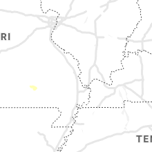
Hail Map for Monday, August 9, 2021

Number of Impacted Households on 8/9/2021
0
Impacted by 1" or Larger Hail
0
Impacted by 1.75" or Larger Hail
0
Impacted by 2.5" or Larger Hail
Square Miles of Populated Area Impacted on 8/9/2021
0
Impacted by 1" or Larger Hail
0
Impacted by 1.75" or Larger Hail
0
Impacted by 2.5" or Larger Hail

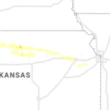


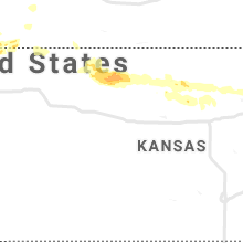


Cities Most Affected by Hail Storms of 8/9/2021
| Hail Size | Demographics of Zip Codes Affected | ||||||
|---|---|---|---|---|---|---|---|
| City | Count | Average | Largest | Pop Density | House Value | Income | Age |
| Bowdon, ND | 2 | 2.75 | 3.00 | 1 | $18k | $25.6k | 54.4 |
| New Rockford, ND | 2 | 1.75 | 1.75 | 6 | $37k | $29.1k | 49.9 |
| Fessenden, ND | 1 | 2.75 | 2.75 | 2 | $31k | $34.4k | 52.8 |
| Sykeston, ND | 1 | 1.75 | 1.75 | 1 | $19k | $26.1k | 50.0 |
| Binford, ND | 1 | 1.75 | 1.75 | 2 | $18k | $27.3k | 56.0 |
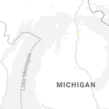
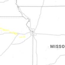
Hail and Wind Damage Spotted on 8/9/2021
Filter by Report Type:Hail ReportsWind Reports
States Impacted
Michigan, Delaware, Kentucky, West Virginia, Illinois, Tennessee, Maryland, District of Columbia, North Dakota, Nebraska, New Mexico, Kansas, MinnesotaMichigan
| Local Time | Report Details |
|---|---|
| 1:00 PM EDT | Tree and utility line damage reported by gladwin co. e in gladwin county MI, 75 miles SE of Traverse City, MI |
| 1:52 PM EDT | Report of a tree dow in oakland county MI, 35.3 miles S of Flint, MI |
| 3:18 PM EDT | Multiple reports of trees down and power line damag in macomb county MI, 48.6 miles SE of Flint, MI |
| 3:18 PM EDT | Multiple reports of trees down and power line damag in macomb county MI, 49.8 miles SE of Flint, MI |
| 3:20 PM EDT | Multiple reports of trees down and power line damag in macomb county MI, 52.7 miles ESE of Flint, MI |
| 3:52 PM EDT | Trees down and reported power outag in st. clair county MI, 54.5 miles E of Flint, MI |
Delaware
| Local Time | Report Details |
|---|---|
| 2:40 PM EDT | Trees and large branches blown down. time estimated from rada in kent county DE, 48.4 miles NNW of Ocean City, MD |
Kentucky
| Local Time | Report Details |
|---|---|
| 2:17 PM CDT | Large branches down. slight siding damage to a traile in barren county KY, 60 miles SSW of Louisville, KY |
| 2:17 PM CDT | Corrects previous tstm wnd dmg report from cave city. large branches down. slight siding damage to a trailer. one tree dow in barren county KY, 62.1 miles SSW of Louisville, KY |
| 2:28 PM CDT | Barn significantly damage in hart county KY, 55.8 miles S of Louisville, KY |
West Virginia
| Local Time | Report Details |
|---|---|
| 5:27 PM EDT | Tree down at 5019 ohio st so. charleston in kanawha county WV, 6.6 miles W of Charleston, WV |
| 5:27 PM EDT | Tree down at washington st w & dumbar ave in kanawha county WV, 5.7 miles WNW of Charleston, WV |
Illinois
| Local Time | Report Details |
|---|---|
| 4:40 PM CDT | Damage to porches along evergreen circle in mchenry. time estimated by rada in mchenry county IL, 46.4 miles NW of Chicago, IL |
| 5:26 PM CDT | Kane county sheriffs office reports damage to a structure along plank road near eagle road. possible tornado. time estimated by rada in kane county IL, 50.1 miles WNW of Chicago, IL |
| 8:55 PM CDT | Power poles down near baker park golf course and another down near new st and high st. time of the event was estimated using rada in henry county IL, 42.7 miles NNW of Peoria, IL |
Tennessee
| Local Time | Report Details |
|---|---|
| 6:05 PM EDT | Numerous trees were blown down around sunbrigh in morgan county TN, 46.1 miles WNW of Knoxville, TN |
Maryland
| Local Time | Report Details |
|---|---|
| 6:24 PM EDT | Powerline wires down on the 1900 block of augusta drive in montgomery county MD, 29.7 miles SW of Baltimore, MD |
| 6:33 PM EDT | Tree down near the intersection of i-495 after md-450 and annapolis road in prince georges county MD, 25.6 miles SW of Baltimore, MD |
District of Columbia
| Local Time | Report Details |
|---|---|
| 6:35 PM EDT | Tree down on the 3000 block of walnut street ne in district of columb county DC, 31.2 miles SW of Baltimore, MD |
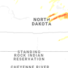
North Dakota
| Local Time | Report Details |
|---|---|
| 5:40 PM CDT | Baseball sized hail reported near Fessenden, ND, 48.4 miles SW of Devils Lake, ND, mostly ping pong balls and golf balls with a few baseballs mixed in. time estimated from radar. |
| 5:53 PM CDT | Tennis Ball sized hail reported near Bowdon, ND, 60.4 miles SW of Devils Lake, ND, relayed via broadcast media. time estimated via radar. |
| 5:55 PM CDT | Quarter sized hail reported near Esmond, ND, 37.1 miles WSW of Devils Lake, ND, dime to quarter sized hail across northern hesper township. hailed off an on for about 5 minutes. |
| 5:56 PM CDT | Golf Ball sized hail reported near Sykeston, ND, 53.8 miles SW of Devils Lake, ND, ongoing at time of call. |
| 5:57 PM CDT | Tea Cup sized hail reported near Bowdon, ND, 55.7 miles SW of Devils Lake, ND, relayed via broadcast media. time estimated via radar. |
| 6:02 PM CDT | Half Dollar sized hail reported near Anamoose, ND, 51.1 miles ESE of Minot, ND |
| 6:21 PM CDT | Ping Pong Ball sized hail reported near New Rockford, ND, 36.4 miles SSW of Devils Lake, ND |
| 6:25 PM CDT | Quarter sized hail reported near Cando, ND, 35.5 miles NW of Devils Lake, ND, dime to quarter sized hail reported across southeastern zion township. nearly covered the ground. |
| 6:25 PM CDT | Half Dollar sized hail reported near Carrington, ND, 39.9 miles SSW of Devils Lake, ND |
| 7:00 PM CDT | Golf Ball sized hail reported near New Rockford, ND, 36.9 miles S of Devils Lake, ND, relayed via social media. time estimated from radar. |
| 7:01 PM CDT | Golf Ball sized hail reported near New Rockford, ND, 34.7 miles S of Devils Lake, ND |
| 7:27 PM CDT | Half Dollar sized hail reported near Starkweather, ND, 21.3 miles N of Devils Lake, ND, quarter to half dollar sized hail for a few minutes. |
| 7:30 PM CDT | Half Dollar sized hail reported near Tolna, ND, 27.8 miles SSE of Devils Lake, ND, very heavy rains anda few quarter to half dollar sized hail. |
| 7:35 PM CDT | Quarter sized hail reported near Carrington, ND, 45.6 miles S of Devils Lake, ND |
| 8:00 PM CDT | Half Dollar sized hail reported near Pekin, ND, 34.8 miles SE of Devils Lake, ND, hail from south of tolna through east of pekin... ranging from nickle to half dollar sized. |
| 8:08 PM CDT | Half Dollar sized hail reported near Mchenry, ND, 37.9 miles SSE of Devils Lake, ND, ongoing at time of report and had been ongoing for approximately 10 minutes. |
| 8:10 PM CDT | Ping Pong Ball sized hail reported near Mchenry, ND, 36.1 miles SSE of Devils Lake, ND, very heavy rain and a few large hail. |
| 8:18 PM CDT | Quarter sized hail reported near Langdon, ND, 45.2 miles NNE of Devils Lake, ND, a few dime to quarter sized hail. |
| 8:26 PM CDT | Golf Ball sized hail reported near Binford, ND, 39.2 miles SE of Devils Lake, ND, golf ball or larger sized hail. photos and reports posted via social media. |
| 8:27 PM CDT | A few large tree limb broken down near red willow lak in griggs county ND, 39.2 miles SSE of Devils Lake, ND |
| 9:03 PM CDT | Quarter sized hail reported near Walhalla, ND, 69.4 miles NE of Devils Lake, ND |
| 9:31 PM CDT | Peak wind measured at an ndawn station at 10 meter in grand forks county ND, 54.5 miles ESE of Devils Lake, ND |
| 10:37 PM CDT | Peak wind measured at the grand forks international airport /kgfk in grand forks county ND, 75.7 miles NNW of Fargo, ND |
| 10:38 PM CDT | 60mph wind gust reported by und clifford hall anemomete in grand forks county ND, 73.4 miles N of Fargo, ND |
| 10:42 PM CDT | Numerous large branches and limbs down along belmont... south of 27t in grand forks county ND, 72 miles N of Fargo, ND |
| 10:48 PM CDT | Peak wind measured at an nddot rwis statio in grand forks county ND, 77.1 miles NNW of Fargo, ND |
| 6:50 AM CDT | Half Dollar sized hail reported near Binford, ND, 44.9 miles SSE of Devils Lake, ND, corrects previous hail report from binford. 1.25" hail. estimated size from picture on facebook. |
Nebraska
| Local Time | Report Details |
|---|---|
| 5:48 PM CDT | Quarter sized hail reported near Gothenburg, NE, 33.3 miles ESE of North Platte, NE, nickel to quarter size hail. |
| 6:24 PM MDT | Site knebenke7 reported 62 mph wind gus in dundy county NE, 58.6 miles NNW of Colby, KS |
| 7:11 PM MDT | Delayed report from kiml asos in chase county NE, 62.6 miles SW of North Platte, NE |
| 8:33 PM CDT | Davis weatherlink statio in dawson county NE, 44.9 miles ESE of North Platte, NE |
| 10:44 PM CDT | Heat burst underway in custer county NE, 60.2 miles WNW of Grand Island, NE |
New Mexico
| Local Time | Report Details |
|---|---|
| 6:15 PM MDT | Hobbs mesonet reported a 67 mph wind gus in lea county NM, 81.5 miles NW of Odessa, TX |
Kansas
| Local Time | Report Details |
|---|---|
| 7:30 PM CDT | Quarter sized hail reported near Saint Francis, KS, 44.3 miles SE of Yuma, CO, hail lasted around 15 minutes. |
| 12:44 AM CDT | Weather station kksbogue1 measured a 65 mph wind gust at 11:44 pm mdt (12:44 am cdt)... and a 59 mph gust at 11:49 pm mdt (12:49 am cdt). wind direction was from the w in graham county KS, 42.2 miles NNW of Hays, KS |
| 1:29 AM CDT | Measured 52kt wind gust at stockton airpor in rooks county KS, 35.2 miles N of Hays, KS |
| 1:35 AM CDT | Mesonet station wl-stockton0.52ss in rooks county KS, 39.4 miles N of Hays, KS |
| 3:05 AM CDT | Weatherlink weather statio in mitchell county KS, 73.7 miles ENE of Hays, KS |
| 5:34 AM CDT | Quarter sized hail reported near Saint George, KS, 7.7 miles E of Manhattan, KS |
Minnesota
| Local Time | Report Details |
|---|---|
| 10:44 PM CDT | Peak wind measured at a personal weather statio in polk county MN, 75.7 miles N of Fargo, ND |
Connect with Interactive Hail Maps