

Hail Map for Wednesday, December 23, 2015

Number of Impacted Households on 12/23/2015
0
Impacted by 1" or Larger Hail
0
Impacted by 1.75" or Larger Hail
0
Impacted by 2.5" or Larger Hail
Square Miles of Populated Area Impacted on 12/23/2015
0
Impacted by 1" or Larger Hail
0
Impacted by 1.75" or Larger Hail
0
Impacted by 2.5" or Larger Hail


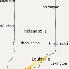


Cities Most Affected by Hail Storms of 12/23/2015
| Hail Size | Demographics of Zip Codes Affected | ||||||
|---|---|---|---|---|---|---|---|
| City | Count | Average | Largest | Pop Density | House Value | Income | Age |
| Jonesboro, AR | 4 | 2.19 | 2.75 | 260 | $99k | $41.6k | 33.1 |
| Bay, AR | 1 | 2.50 | 2.50 | 40 | $51k | $31.7k | 36.7 |
| Mobile, AL | 1 | 2.00 | 2.00 | 1673 | $56k | $25.7k | 33.2 |
| Cotton Plant, AR | 1 | 2.00 | 2.00 | 4 | $21k | $14.4k | 45.8 |
| Rhodelia, KY | 1 | 1.75 | 1.75 | 25 | $0k | $0.0k | 36.5 |
| Wynne, AR | 1 | 1.75 | 1.75 | 52 | $69k | $30.9k | 38.8 |
| Wingo, KY | 1 | 1.75 | 1.75 | 44 | $59k | $37.2k | 39.7 |
| Lake City, AR | 1 | 1.75 | 1.75 | 26 | $48k | $31.9k | 38.1 |
| Providence, KY | 1 | 1.75 | 1.75 | 73 | $34k | $28.3k | 41.8 |
| Des Arc, AR | 1 | 1.75 | 1.75 | 10 | $56k | $25.8k | 44.4 |
Hail and Wind Damage Spotted on 12/23/2015
Filter by Report Type:Hail ReportsWind Reports
States Impacted
Oklahoma, Alabama, Arkansas, Illinois, Missouri, Indiana, South Carolina, Mississippi, Kentucky, Ohio, Tennessee, Michigan, West Virginia, GeorgiaOklahoma
| Local Time | Report Details |
|---|---|
| 6:00 AM CST | Quarter sized hail reported near Idabel, OK, 62.2 miles W of Nashville, AR |
| 6:43 AM CST | Trees down on houses and on vehicles on sylvie road. power lines down as wel in mccurtain county OK, 51.6 miles W of Nashville, AR |
| 6:47 AM CST | Several trees and power lines down in broken bo in mccurtain county OK, 51.5 miles W of Nashville, AR |
Alabama
| Local Time | Report Details |
|---|---|
| 6:30 AM CST | Trees across the road at fort lake rd and gaston loop rd. time estimated from rada in mobile county AL, 21.6 miles WSW of Mobile, AL |
| 6:48 AM CST | Trees and power lines down on old pascagoula rd. near carrol plantation rd. time estimated via rada in mobile county AL, 10.5 miles SW of Mobile, AL |
| 7:00 AM CST | Hen Egg sized hail reported near Mobile, AL, 4.8 miles SW of Mobile, AL, 2 inch hail reported via broadcast media. size estimated from viewer photo. |
| 7:30 AM CST | Media reports trees across roadway at fort lake road and gaston loop road in mobile county AL, 21.6 miles WSW of Mobile, AL |
| 7:00 PM CST | Small trees down along county road 54 between cr 14 and 21. time estimated from rada in lauderdale county AL, 24.5 miles WNW of Florence, AL |
| 12:10 AM CST | Tree down in elba. time estimated from rada in coffee county AL, 78.1 miles SSW of Auburn, AL |
| 12:10 AM CST | Tree down. time estimated from rada in coffee county AL, 69.3 miles NNE of Miramar Beach, FL |
| 12:10 AM CST | Tree down across the road. time estimated from rada in coffee county AL, 70.3 miles NNE of Miramar Beach, FL |
Arkansas
| Local Time | Report Details |
|---|---|
| 7:16 AM CST | Multiple reports of trees and power lines down around the count in yell county AR, 62.7 miles ESE of Fort Smith, AR |
| 7:30 AM CST | Multiple reports of trees and power lines down around the count in yell county AR, 62.7 miles ESE of Fort Smith, AR |
| 7:40 AM CST | *** 1 fatal *** local coordinator reported fallen tree on house in atkins. there were also reoprts of trees and power lines down in the southeast part of pope count in pope county AR, 51.1 miles NW of Little Rock, AR |
| 7:55 AM CST | Local coordinator reported fallen tree on house in atkins. there were also reoprts of trees and power lines down in the southeast part of pope count in pope county AR, 51.1 miles NW of Little Rock, AR |
| 8:01 AM CST | Trees uprooted and damage to awning in yar in searcy county AR, 76.6 miles NNW of Little Rock, AR |
| 8:18 AM CST | Observer reported both powerlines and large pine trees dow in van buren county AR, 46.3 miles N of Little Rock, AR |
| 8:20 AM CST | Large tree was reported blocking highway 5 sout in baxter county AR, 90.5 miles SE of Springfield, MO |
| 8:20 AM CST | Damage to a house was reported in bee branc in van buren county AR, 48.9 miles N of Little Rock, AR |
| 8:26 AM CST | A tree was reported on a house in fairfield ba in van buren county AR, 59.4 miles N of Little Rock, AR |
| 8:30 AM CST | Numerous trees and powerlines down in town. trees blocking roadway in pope county AR, 59.4 miles NW of Little Rock, AR |
| 8:40 AM CST | Law enforcement reports that a roof was displaced from a bar in fulton county AR, 89.8 miles SSW of Salem, MO |
| 8:40 AM CST | Law enforcement reports that a roof was displaced from a bar in fulton county AR, 89.8 miles SSW of Salem, MO |
| 8:40 AM CST | Two homes were reported with trees on them as well as a barn blow down and roof damage to others. highway 87 was blocked with trees north of mountain vie in stone county AR, 77.9 miles N of Little Rock, AR |
| 8:41 AM CST | Emergency management reports wind damage to a mobile hom in independence county AR, 81.5 miles NNE of Little Rock, AR |
| 8:50 AM CST | Law enforecment reports power lines and power line poles dow in fulton county AR, 88.8 miles S of Salem, MO |
| 9:07 AM CST | Law enforcement reported several homes destroyed and a lot of structural damage in the highland are in sharp county AR, 92.9 miles S of Salem, MO |
| 9:30 AM CST | Tree down on muddy lan in lawrence county AR, 96.4 miles NW of Memphis, TN |
| 9:30 AM CST | Trees down in ravende in lawrence county AR, 97.6 miles S of Salem, MO |
| 9:50 AM CST | Tree down in maynar in randolph county AR, 91 miles SSE of Salem, MO |
| 11:40 AM CST | Reports of power lines down along highway 236 around clay hil in lonoke county AR, 23.7 miles ENE of Little Rock, AR |
| 11:43 AM CST | Report of a tree down on evening street in judsonia in white county AR, 51.3 miles NE of Little Rock, AR |
| 1:00 PM CST | Quarter sized hail reported near Jonesboro, AR, 64.2 miles NNW of Memphis, TN, quarter sized hail reported 11 miles sw of paragould |
| 1:10 PM CST | Golf Ball sized hail reported near Des Arc, AR, 46.3 miles ENE of Little Rock, AR, report of golf ball sized hail in des arc. |
| 1:13 PM CST | Quarter sized hail reported near Jonesboro, AR, 58.7 miles NW of Memphis, TN, local law enforement reports quarter sized hail south of jonesboro |
| 1:15 PM CST | Golf Ball sized hail reported near Jonesboro, AR, 53.4 miles NW of Memphis, TN |
| 1:15 PM CST | Tennis Ball sized hail reported near Jonesboro, AR, 53.4 miles NW of Memphis, TN |
| 1:15 PM CST | Power lines down in craighead county AR, 53.4 miles NW of Memphis, TN |
| 1:20 PM CST | Ping Pong Ball sized hail reported near England, AR, 21.3 miles SE of Little Rock, AR |
| 1:21 PM CST | Golf Ball sized hail reported near Jonesboro, AR, 53.9 miles NNW of Memphis, TN |
| 1:27 PM CST | Tennis Ball sized hail reported near Bay, AR, 49.9 miles NW of Memphis, TN |
| 1:27 PM CST | Baseball sized hail reported near Jonesboro, AR, 58.4 miles NW of Memphis, TN |
| 1:37 PM CST | Half Dollar sized hail reported near Carlisle, AR, 29.9 miles E of Little Rock, AR |
| 1:58 PM CST | Storm damage reported in mississippi county AR, 51.3 miles N of Memphis, TN |
| 2:02 PM CST | Golf Ball sized hail reported near Wynne, AR, 55.8 miles W of Memphis, TN |
| 2:05 PM CST | Hen Egg sized hail reported near Cotton Plant, AR, 60.9 miles ENE of Little Rock, AR |
| 2:43 PM CST | Golf Ball sized hail reported near Lake City, AR, 51.4 miles NNW of Memphis, TN |
Illinois
| Local Time | Report Details |
|---|---|
| 8:25 AM CST | Several trees down east of waterloo. time estimated from rada in monroe county IL, 20.6 miles S of Saint Louis, MO |
| 8:36 AM CST | Damage to a fence. time estimate from radar in st. clair county IL, 20.8 miles SE of Saint Louis, MO |
| 9:40 AM CST | Several small tree blown ove in shelby county IL, 26.5 miles W of Mattoon, IL |
| 9:44 AM CST | One half mile east of fairbury on us 24. power pole down due to wind in livingston county IL, 56.7 miles E of Peoria, IL |
| 9:50 AM CST | Shed blow dow in shelby county IL, 24.2 miles WSW of Mattoon, IL |
| 9:57 AM CST | House shingles blown off tow sheds blown dow in macon county IL, 34.7 miles NW of Mattoon, IL |
| 9:58 AM CST | Roof partially torn off a churc in macon county IL, 34.7 miles NW of Mattoon, IL |
| 10:04 AM CST | Grain bin thrown into a fiel in de witt county IL, 50.9 miles NNW of Mattoon, IL |
| 10:15 AM CST | Semi blown over on cadwell road between sullivan and cadwell. reported by emergency manager via nws cha in moultrie county IL, 15.8 miles NW of Mattoon, IL |
| 10:35 AM CST | Six power-line poles down in champaign county IL, 60 miles N of Mattoon, IL |
| 11:05 AM CST | Storm damage reported in randolph county IL, 43 miles SE of Saint Louis, MO |
| 11:25 AM CST | Tree down along hwy 4 and along dallas road near murphysbor in jackson county IL, 40.6 miles N of Cape Girardeau, MO |
| 11:29 AM CST | Reported near unity point schoo in jackson county IL, 29.9 miles NE of Cape Girardeau, MO |
| 11:30 AM CST | Late report. time estimated. structure damage to home reported via multi medi in jefferson county IL, 71 miles NNE of Cape Girardeau, MO |
| 11:30 AM CST | Late report. time estimated. structure damage to hom in franklin county IL, 51.8 miles NNE of Cape Girardeau, MO |
| 11:39 AM CST | Winds estimated. large tree down in the community. metal framed barn collapse in franklin county IL, 60.7 miles NNE of Cape Girardeau, MO |
| 11:42 AM CST | Power line down along herrin roa in williamson county IL, 44.4 miles NE of Cape Girardeau, MO |
| 11:45 AM CST | Power pole snapped at ground level on new street. portion of hwy 154 closed due to downed tree in perry county IL, 54.4 miles N of Cape Girardeau, MO |
| 11:50 AM CST | Tree down blocking portion of south bound interstate 57. trees down along moak school road... colman road and roberts roa in williamson county IL, 44.4 miles NE of Cape Girardeau, MO |
| 12:03 PM CST | Winds estimated 50 to 60 mph. reported by off duty nws employe in johnson county IL, 37.9 miles ENE of Cape Girardeau, MO |
| 12:06 PM CST | Storm damage reported in wayne county IL, 63.1 miles WNW of Evansville, IN |
| 12:10 PM CST | Barn doors blown in on south side... partial roof blown off of barn and east wall bowed out 18 inches. barn size 40 foot by 80 foot - on butternut roa in clay county IL, 56.4 miles SSW of Mattoon, IL |
| 12:15 PM CST | Nearly 2 dozen trees snapped in the communit in white county IL, 34 miles WNW of Evansville, IN |
| 12:25 PM CST | 6 to 8 inch pine trees snapped. machine shed roof lost along county road 122 in white county IL, 28.3 miles W of Evansville, IN |
| 12:57 PM CST | Winds estimated 55 to 65 mp in wabash county IL, 32.6 miles NNW of Evansville, IN |
| 1:06 PM CST | 2 ameren power poles snapped off at the groun in lawrence county IL, 52.1 miles N of Evansville, IN |
| 2:33 PM CST | Quarter sized hail reported near Villa Ridge, IL, 21.9 miles ESE of Cape Girardeau, MO |
| 3:15 PM CST | Quarter sized hail reported near Quincy, IL, 38.1 miles SSE of Kahoka, MO, about 2 to 3 min of hail. largest hailstone was slightly larger than a quarter. |
| 3:17 PM CST | Half Dollar sized hail reported near Quincy, IL, 38.1 miles SSE of Kahoka, MO |
| 3:22 PM CST | Ping Pong Ball sized hail reported near Quincy, IL, 38.1 miles SSE of Kahoka, MO, report relayed through amateur radio |
| 3:52 PM CST | Quarter sized hail reported near Golden, IL, 42.7 miles ESE of Kahoka, MO, hail ranging from peas to quarters reported in golden. visibility less than 100 ft in heavy rain. |
| 4:24 PM CST | Location corrected. time approximated. emergency manager reported power poles and lines down in the adair are in mcdonough county IL, 50.1 miles WSW of Peoria, IL |
| 4:24 PM CST | Time and location approximated. emergency manager reported power poles and lines down in the adair are in mcdonough county IL, 51.5 miles WSW of Peoria, IL |
Missouri
| Local Time | Report Details |
|---|---|
| 8:40 AM CST | Power lines down... shed blown over... trees dow in howell county MO, 80.3 miles SSW of Salem, MO |
| 8:50 AM CST | Delayed storm report - a large tree was blown down on to an outdoor patio structure and outbuildings. a couple outbuildings were heavily damaged. a brick wall was compl in howell county MO, 66.9 miles SSW of Salem, MO |
| 9:10 AM CST | Trees and one power pole blown over in thaye in oregon county MO, 77 miles S of Salem, MO |
| 9:16 AM CST | Severe thunderstorm wind gusts downed a large tree in the community of alto in oregon county MO, 65.7 miles S of Salem, MO |
| 9:16 AM CST | Severe thunderstorm wind gusts downed a large tree along highway 19 just north of greer sprin in oregon county MO, 60 miles S of Salem, MO |
| 9:45 AM CST | Late report. numerous trees down in a defined path near big springs along hwy in carter county MO, 57.3 miles SSE of Salem, MO |
| 9:55 AM CST | Late report. downed power lines and debris across roadwa in carter county MO, 61.7 miles SE of Salem, MO |
| 9:55 AM CST | Power lines down along portions of hwy 21. the hwy is closing at this tim in carter county MO, 65.2 miles SE of Salem, MO |
| 9:55 AM CST | Power lines down along portions of hwy 21. the hwy is closing at this tim in carter county MO, 65.2 miles SE of Salem, MO |
| 10:00 AM CST | Portions of community without power in wayne county MO, 56.9 miles SE of Salem, MO |
| 10:10 AM CST | Downed and uprooted trees along hwy 34. pea size hail and heavy rain. road partially closed in wayne county MO, 51.3 miles WSW of Cape Girardeau, MO |
| 10:12 AM CST | Reported by e in ripley county MO, 77.7 miles SW of Cape Girardeau, MO |
| 10:17 AM CST | Portions of community without power in wayne county MO, 56.9 miles SE of Salem, MO |
| 10:40 AM CST | Power outages reported throughout the county. tree down along hwy 51 just north of hwy cc. carport roof blown off 10 miles north on hwy m. barn collapsed along hwy 306 in bollinger county MO, 24 miles W of Cape Girardeau, MO |
| 10:45 AM CST | Tree down on hous in stoddard county MO, 42.6 miles SW of Cape Girardeau, MO |
| 11:20 AM CST | Late report. several tree limbs dow in cape girardeau county MO, 0.6 miles NNW of Cape Girardeau, MO |
| 12:29 PM CST | Power line down blocking roa in mississippi county MO, 37.2 miles SSE of Cape Girardeau, MO |
| 1:58 PM CST | Quarter sized hail reported near Kennett, MO, 75.2 miles N of Memphis, TN |
| 2:04 PM CST | Quarter sized hail reported near Sikeston, MO, 29.2 miles S of Cape Girardeau, MO, quarter size hail reported via multi media. |
| 2:15 PM CST | Storm damage reported in pemiscot county MO, 63.4 miles WNW of Mc Kenzie, TN |
| 2:49 PM CST | Quarter sized hail reported near Monroe City, MO, 51.1 miles S of Kahoka, MO |
| 3:00 PM CST | Quarter sized hail reported near Monroe City, MO, 55.3 miles S of Kahoka, MO |
| 3:07 PM CST | Quarter sized hail reported near Palmyra, MO, 44.1 miles SSE of Kahoka, MO, marion county 911 reports quarter size hail near palmyra |
Indiana
| Local Time | Report Details |
|---|---|
| 12:50 PM CST | Two semi tractor trailers overturned along interstate 6 in gibson county IN, 26.4 miles N of Evansville, IN |
| 2:26 PM EST | Storm damage reported in knox county IN, 57.1 miles NNE of Evansville, IN |
| 2:35 PM EST | Semi blown over on near us41 north of decker in knox county IN, 41.7 miles N of Evansville, IN |
| 2:39 PM EST | Tree down across power line between 9th and 10th on vigo street in knox county IN, 57.1 miles NNE of Evansville, IN |
| 1:44 PM CST | Wind gust estimated in warrick county IN, 9.2 miles ESE of Evansville, IN |
| 2:49 PM EST | Storm damage reported in marion county IN, 0.9 miles N of Indianapolis, IN |
| 2:49 PM EST | Storm damage reported in daviess county IN, 46.9 miles NNE of Evansville, IN |
| 1:55 PM CST | Power lines down along south side of city. power outages also reported on west side of city as well as a billboard blown ove in vanderburgh county IN, 1.3 miles E of Evansville, IN |
| 3:03 PM EST | Wind gust from jasper middle school in dubois county IN, 44.3 miles NE of Evansville, IN |
| 3:04 PM EST | Trees down near sr59 and 100w in greene county IN, 66.2 miles SW of Indianapolis, IN |
| 3:05 PM EST | Semi trailer blown off us231 at i-70. one injure in putnam county IN, 37.7 miles WSW of Indianapolis, IN |
| 3:05 PM EST | Box trailer overturned... trees and tree limbs down... some power outages in putnam county IN, 41.2 miles WSW of Indianapolis, IN |
| 2:08 PM CST | Several trees dow in spencer county IN, 19.5 miles ESE of Evansville, IN |
| 2:08 PM CST | Several trees dow in spencer county IN, 32.3 miles ENE of Evansville, IN |
| 3:10 PM EST | Storm damage reported in dubois county IN, 41.1 miles ENE of Evansville, IN |
| 3:10 PM EST | Power lines on a ca in dubois county IN, 42.2 miles ENE of Evansville, IN |
| 3:22 PM EST | Power lines dow in dubois county IN, 43.9 miles ENE of Evansville, IN |
| 3:25 PM EST | Barn door blew in near us40 and zero road in hendricks county IN, 20.8 miles WSW of Indianapolis, IN |
| 3:25 PM EST | Measured on the west side of danville in hendricks county IN, 19.7 miles W of Indianapolis, IN |
| 3:27 PM EST | Two barns damaged... extent unknow in orange county IN, 50.3 miles NW of Louisville, KY |
| 3:30 PM EST | Power lines down near highway 37 near orleans. trees down elsewhere in the count in orange county IN, 61 miles NW of Louisville, KY |
| 3:35 PM EST | Minor roof damage and an aluminum car port lifted off its bas in orange county IN, 47.5 miles NW of Louisville, KY |
| 3:45 PM EST | Many trees down in the county... especially on highway 56 near the salem airpor in washington county IN, 47.8 miles NNW of Louisville, KY |
| 3:47 PM EST | Several large tree limbs down near olive branch road and sr135 in johnson county IN, 10.4 miles SSE of Indianapolis, IN |
| 3:50 PM EST | Tree damage to relatively large trees and roof off of a garage on acadamy roa in shelby county IN, 18.7 miles SE of Indianapolis, IN |
| 3:55 PM EST | Storm damage reported in jackson county IN, 57.4 miles SSE of Indianapolis, IN |
| 4:00 PM EST | Several large tree limbs down... winds measured at 58mph in hamilton county IN, 12.1 miles N of Indianapolis, IN |
| 4:10 PM EST | Trees and a flagpole down in madison county IN, 39 miles NNE of Indianapolis, IN |
| 4:12 PM EST | Semi blown over in hancock county IN, 19.9 miles NE of Indianapolis, IN |
| 4:12 PM EST | Buildings damaged in rush county IN, 40.5 miles ESE of Indianapolis, IN |
| 4:15 PM EST | Power lines down. no power for 30 minute in rush county IN, 38.8 miles ESE of Indianapolis, IN |
| 4:20 PM EST | Trees down with gusts estimated at 60mph in madison county IN, 33.1 miles NE of Indianapolis, IN |
| 4:20 PM EST | Houses damaged... trees down and power outages in rushville in rush county IN, 38.8 miles ESE of Indianapolis, IN |
| 4:21 PM EST | Semi blown over on i74 near mm101 in marion county IN, 5.6 miles WSW of Indianapolis, IN |
| 4:25 PM EST | Trees down on house near 161st and seminole road in hamilton county IN, 21.2 miles NNE of Indianapolis, IN |
| 4:26 PM EST | Pole barn destroyed in rush county IN, 37.7 miles E of Indianapolis, IN |
| 4:29 PM EST | Power poles down in madison county IN, 38 miles NE of Indianapolis, IN |
| 4:30 PM EST | Storm damage reported in henry county IN, 45.9 miles E of Indianapolis, IN |
| 4:35 PM EST | Large tree down across sanes rd. near w. johnson school rd. time estimated by rada in fayette county IN, 49.9 miles NW of Cincinnati, OH |
| 4:35 PM EST | One healthy tree uproote in wayne county IN, 54.4 miles E of Indianapolis, IN |
| 4:45 PM EST | Two 2 1/2 foot diameter pine trees down in wayne county IN, 50.7 miles E of Indianapolis, IN |
| 4:51 PM EST | 2 trees down. one on state route 229 and one on weatherman road in franklin county IN, 31.9 miles WNW of Cincinnati, OH |
| 4:51 PM EST | Trees down state route 229 as well as weatherman road in franklin county IN, 32.9 miles WNW of Cincinnati, OH |
| 4:54 PM EST | Multiple trees and power lines down in randolph county IN, 63.2 miles S of Fort Wayne, IN |
| 4:55 PM EST | Lost power temporaril in dearborn county IN, 22.2 miles WNW of Cincinnati, OH |
| 5:00 PM EST | Storm damage reported in henry county IN, 44.4 miles E of Indianapolis, IN |
| 5:01 PM EST | One tree knocked down onto hous in wayne county IN, 50.7 miles E of Indianapolis, IN |
| 5:35 PM EST | One healthy tree uprooted in wayne county IN, 53.3 miles E of Indianapolis, IN |
| 6:36 PM EST | Quarter sized hail reported near Corydon, IN, 27.2 miles NW of Louisville, KY |
| 6:38 PM EST | 3-4 large trees down in harrison county IN, 22.9 miles NW of Louisville, KY |
| 6:59 PM EST | Power poles dow in clark county IN, 20.2 miles N of Louisville, KY |
| 7:00 PM EST | Quarter sized hail reported near Clarksville, IN, 21 miles N of Louisville, KY, delayed report. |
| 7:42 PM EST | Tree down at riverside dr. and whitelock s in huntington county IN, 24.5 miles WSW of Fort Wayne, IN |
South Carolina
| Local Time | Report Details |
|---|---|
| 2:00 PM EST | Trees down on power lines. time estimated by rada in lexington county SC, 42.3 miles NE of Augusta, GA |
| 2:03 PM EST | Power lines down across road in lexington county SC, 55.5 miles NE of Augusta, GA |
| 2:05 PM EST | Trees down on murray lindler road. time estimated by rada in lexington county SC, 58.6 miles NE of Augusta, GA |
| 4:40 PM EST | Trees down on power lines. time estimated by rada in lexington county SC, 42.3 miles NE of Augusta, GA |
Mississippi
| Local Time | Report Details |
|---|---|
| 2:56 PM CST | Trees were down in the northern part of the county. possible tornad in bolivar county MS, 86 miles SSW of Memphis, TN |
| 3:00 PM CST | At least 15 homes severely damaged or destroyed just south of clarksdale. time is radar estimate in coahoma county MS, 72.7 miles SSW of Memphis, TN |
| 4:00 PM CST | Power line down in tow in sunflower county MS, 96.3 miles SSW of Memphis, TN |
Kentucky
| Local Time | Report Details |
|---|---|
| 3:03 PM CST | Golf Ball sized hail reported near Providence, KY, 41.1 miles SSW of Evansville, IN, golf ball size hail reported. |
| 3:24 PM CST | Quarter sized hail reported near Mayfield, KY, 42.5 miles N of Mc Kenzie, TN, quarter size hail reported. |
| 3:26 PM CST | Power outages reported throughout the downtown are in mccracken county KY, 52.4 miles ESE of Cape Girardeau, MO |
| 3:26 PM CST | Reported by off duty nws employe in marshall county KY, 62.6 miles N of Mc Kenzie, TN |
| 3:30 PM CST | Late report. tree down along arant road and one down along j.b. copeland roa in marshall county KY, 50.9 miles N of Mc Kenzie, TN |
| 3:31 PM CST | Golf Ball sized hail reported near Wingo, KY, 37.1 miles NNW of Mc Kenzie, TN, brief period of very large hail reported. |
| 3:32 PM CST | Wind gust estimated. storm also producing pea to marble size hai in livingston county KY, 62.5 miles NNE of Mc Kenzie, TN |
| 3:34 PM CST | Wind gust estimated. storm producing pea size hail. event occurred along hwy 68 west near mile marker 4. small tree limbs dow in marshall county KY, 50.2 miles N of Mc Kenzie, TN |
| 3:38 PM CST | Quarter sized hail reported near Symsonia, KY, 55 miles N of Mc Kenzie, TN, quarter size hail reported. |
| 4:18 PM CST | Quarter sized hail reported near Slaughters, KY, 33.8 miles S of Evansville, IN, quarter size hail reported. |
| 4:22 PM CST | Powerlines dow in calloway county KY, 36.2 miles NNE of Mc Kenzie, TN |
| 4:27 PM CST | Broken glass door in calloway county KY, 34.7 miles NNE of Mc Kenzie, TN |
| 4:30 PM CST | 65 x 30 feet wooden barn blew into road and knocked down power lines. barn destroye in calloway county KY, 41.5 miles NNE of Mc Kenzie, TN |
| 4:57 PM CST | 2 trees down in lynn grove in calloway county KY, 31.8 miles N of Mc Kenzie, TN |
| 5:05 PM CST | A tree fell on a house in trigg county KY, 64 miles NE of Mc Kenzie, TN |
| 5:08 PM CST | Quarter sized hail reported near Hawesville, KY, 49.9 miles ESE of Evansville, IN |
| 6:20 PM EST | Golf Ball sized hail reported near Rhodelia, KY, 37.3 miles W of Louisville, KY |
| 5:23 PM CST | Power outages in southern part of the crofton. also...pea size hail in christian county KY, 64.1 miles S of Evansville, IN |
| 5:30 PM CST | Several trees down in muhlenberg county KY, 58.2 miles SSE of Evansville, IN |
| 5:35 PM CST | Tree down on power line on river road in muhlenberg county KY, 52.4 miles SSE of Evansville, IN |
| 5:42 PM CST | One large tree down in christian county KY, 67.6 miles NNW of Nashville, TN |
| 5:44 PM CST | Power outages in the city and northern part of the county in christian county KY, 61.5 miles NW of Nashville, TN |
| 6:00 PM CST | Storm damage reported in breckinridge county KY, 47.4 miles WSW of Louisville, KY |
| 7:00 PM EST | Tree down on a buildin in jefferson county KY, 17.4 miles N of Louisville, KY |
| 7:04 PM EST | Trees dow in jefferson county KY, 17.3 miles NNW of Louisville, KY |
| 7:22 PM EST | Tree down on a buildin in jefferson county KY, 17.4 miles N of Louisville, KY |
| 7:49 PM EST | Tree blown dow in owen county KY, 44.6 miles SSW of Cincinnati, OH |
| 7:52 PM EST | Kentucky mesonet station measured wind gus in owen county KY, 40.4 miles SSW of Cincinnati, OH |
| 8:00 PM EST | Storm damage reported in grant county KY, 23.2 miles SSW of Cincinnati, OH |
| 8:11 PM EST | Two trailers blown over in pendleton county KY, 27.6 miles SSE of Cincinnati, OH |
| 8:11 PM EST | Report of another flipped mobile home at fardo road in pendleton county KY, 21.3 miles SSE of Cincinnati, OH |
| 8:11 PM EST | Roof blown off house in pendleton county KY, 28.9 miles SSE of Cincinnati, OH |
| 8:16 PM EST | Barn blown over near lanes end rd. with numerous trees down throughout county. time estimated by rada in campbell county KY, 20.6 miles SE of Cincinnati, OH |
| 8:19 PM EST | Several trees down across county... including along snag creek rd. time estimated by rada in bracken county KY, 28.9 miles SE of Cincinnati, OH |
| 8:30 PM EST | Two trailers blown over in pendleton county KY, 27.6 miles SSE of Cincinnati, OH |
| 8:30 PM EST | Two trailers blown over in pendleton county KY, 27.6 miles SSE of Cincinnati, OH |
| 8:35 PM EST | Several small trees dow in scott county KY, 49.5 miles S of Cincinnati, OH |
| 8:50 PM EST | Storm damage reported in franklin county KY, 46.5 miles ENE of Louisville, KY |
| 7:50 PM CST | Storm damage reported in simpson county KY, 36.9 miles NNE of Nashville, TN |
| 10:07 PM EST | Roof damage... camper blown over... trees and power lines down. barns damaged. near hwy 55 and old columbia road... and mclean road near green county lin in taylor county KY, 52.2 miles SSE of Louisville, KY |
Ohio
| Local Time | Report Details |
|---|---|
| 4:51 PM EST | 2 trees down. one on state route 229 and one on weatherman road in xxx county XX, 66.9 miles SE of Columbus, OH |
| 4:54 PM EST | Storm damage reported in butler county OH, 30.9 miles NNW of Cincinnati, OH |
| 5:00 PM EST | Large tree fell on hous in preble county OH, 37.6 miles NNW of Cincinnati, OH |
| 5:00 PM EST | One large tree knocked dow in preble county OH, 44.9 miles N of Cincinnati, OH |
| 5:05 PM EST | Half a barn blown down at maple and victoria. top 4 feet of a 2 foot tree broke in preble county OH, 56.2 miles N of Cincinnati, OH |
| 5:05 PM EST | Part of a roof blown off in el dorado. time estimated by rada in preble county OH, 55.5 miles N of Cincinnati, OH |
| 5:05 PM EST | Building roof blown off. numerous large trees down on roadways and lines dow in darke county OH, 61.6 miles N of Cincinnati, OH |
| 5:07 PM EST | Multiple trees down across preble county...including near intersection of 725 and upper somers rd. time estimated by rada in preble county OH, 36.6 miles N of Cincinnati, OH |
| 5:19 PM EST | Storm damage reported in butler county OH, 30.9 miles NNW of Cincinnati, OH |
| 5:23 PM EST | Miami county emergengy manager reported multiple buildings damaged at 1845 north rangeline road. he will conduct a damage survey tomorrow mornin in miami county OH, 66.2 miles N of Cincinnati, OH |
| 5:23 PM EST | Barn destroyed by win in miami county OH, 62.7 miles N of Cincinnati, OH |
| 5:40 PM EST | One large tree knocked dow in preble county OH, 44.9 miles N of Cincinnati, OH |
| 5:42 PM EST | Power pole with lines down across the roadway in van wert county OH, 37.6 miles ESE of Fort Wayne, IN |
| 5:45 PM EST | Numerous trees down in warren county OH, 24.7 miles NNE of Cincinnati, OH |
| 5:55 PM EST | Tree fell on car traveling on roa in champaign county OH, 46.1 miles WNW of Columbus, OH |
| 5:58 PM EST | Large tree down near intersection of township rd. 30 and county road 18. time estimated by rada in logan county OH, 48.8 miles WNW of Columbus, OH |
| 6:07 PM EST | Lucas county sheriff reports power lines down near the intersection of sylvania avenue and kilburn roa in lucas county OH, 80.2 miles ENE of Fort Wayne, IN |
| 6:10 PM EST | Hancock county sheriff reports a barn collapsed due to winds on township road 118 in nw hancock count in hancock county OH, 65.9 miles E of Fort Wayne, IN |
| 10:24 PM EST | A few tree limbs down in tuscarawas county OH, 77.3 miles ENE of Columbus, OH |
Tennessee
| Local Time | Report Details |
|---|---|
| 4:00 PM CST | Quarter sized hail reported near Dyersburg, TN, 46.4 miles W of Mc Kenzie, TN, quarter sized hail and gusty winds on east side of dyersburg. |
| 4:18 PM CST | Ping Pong Ball sized hail reported near Mason, TN, 33.9 miles ENE of Memphis, TN, ping pong size hail in mason tn |
| 6:20 PM CST | Likely tornado damage to homes near hwy 412 e and hurricane creek rd in perry county TN, 55.4 miles SE of Mc Kenzie, TN |
| 6:25 PM CST | *** 2 fatal *** 2 deaths in house between linden and hohenwald in perry county TN, 53.1 miles N of Florence, AL |
| 6:26 PM CST | Reports of power lines down and trees down and roof damage in mt pleasan in maury county TN, 48.5 miles SSW of Nashville, TN |
| 6:26 PM CST | Trees across the road on cane creek rd in pleasantvill in hickman county TN, 55.9 miles SE of Mc Kenzie, TN |
| 6:34 PM CST | Trees down. report received via twitte in hickman county TN, 55.7 miles SW of Nashville, TN |
| 6:45 PM CST | Two reports of trees down one at least 2 feet in diameter and 60 customers without power near hwy 49 west and hwy 46 nort in dickson county TN, 42.1 miles W of Nashville, TN |
| 7:16 PM CST | Wayne county post office destroyed in lutts. multiple homes damaged and powerlines down. multiple injuries reported. report was relayed by lawrence co ema. likely torna in wayne county TN, 26 miles NNW of Florence, AL |
| 7:30 PM CST | Damage to home on napier rd. fire and rescue responding. possible tornad in lawrence county TN, 40.6 miles NNE of Florence, AL |
| 7:35 PM CST | Mobile home heavy damaged on 175 rice roa in lawrence county TN, 47.4 miles NNE of Florence, AL |
| 7:38 PM CST | Home received damage on hwy 20 from likely tornad in lawrence county TN, 48.9 miles NNE of Florence, AL |
| 7:41 PM CST | Hwy 64 blocked at ovilla at lawrence wayne county line. guard rails pulled u in lawrence county TN, 36.3 miles N of Florence, AL |
| 7:42 PM CST | Numerous trees down 2 feet in diameter on hwy 241 about 2 miles north of sr 240. possible tor damage in lawrence county TN, 39.8 miles NNE of Florence, AL |
| 7:46 PM CST | Two houses destroyed near summertown. possible tor damage in lawrence county TN, 38.4 miles NNE of Florence, AL |
| 7:52 PM CST | Damage concentrated along a line from sr 241 towards a point 3 miles west of summertown. twenty plus structures damaged or destroye in lawrence county TN, 45.6 miles NNE of Florence, AL |
| 9:28 PM CST | Sign blown down at arbys in murfreesboro... at old fort parkway and i-2 in rutherford county TN, 30.9 miles SE of Nashville, TN |
| 9:54 PM CST | A tree was blown down on belotes ferry rd near flippen r in wilson county TN, 27.2 miles ENE of Nashville, TN |
| 10:12 PM CST | Trees down in the alexandria area including a tree on a house on lower helton r in de kalb county TN, 42.3 miles E of Nashville, TN |
| 10:20 PM CST | Garage destroyed... porches removed... and roof damage on maynard hollow ln. possible tornad in smith county TN, 50.9 miles E of Nashville, TN |
| 10:25 PM CST | Trees blocking the road... along highway 85... near jackson/overton county lin in jackson county TN, 72 miles ENE of Nashville, TN |
| 10:54 PM CST | Trees down on powerlines on willow grove highwa in overton county TN, 84 miles WNW of Knoxville, TN |
Michigan
| Local Time | Report Details |
|---|---|
| 6:05 PM EST | Multiple roofs off in mobile home park along us 22 in lenawee county MI, 81.4 miles S of Flint, MI |
| 6:08 PM EST | Barn destroyed with debris scattered up to 50 yards away in lenawee county MI, 75.5 miles S of Flint, MI |
| 6:44 PM EST | Multiple buildings and vehicles damaged in industrial area along lilley between warren and jo in wayne county MI, 47.7 miles SSE of Flint, MI |
| 2:30 AM EST | Numerous trees and power lines down throughout newaygo county. at least 5000 without powe in newaygo county MI, 42 miles N of Grand Rapids, MI |
West Virginia
| Local Time | Report Details |
|---|---|
| 11:30 PM EST | Damage in the vicinity of south 6th street in parkersburg west virginia. damage to several trailers including roof damage and damage to underpinnings. several large tre in wood county WV, 63 miles N of Charleston, WV |
Georgia
| Local Time | Report Details |
|---|---|
| 5:46 AM EST | Ham radio reports multiple trees down in the are in paulding county GA, 34.5 miles WNW of Atlanta, GA |
Connect with Interactive Hail Maps