

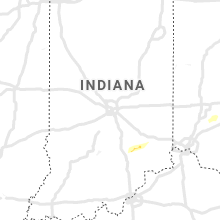
Hail Map for Sunday, December 5, 2021

Number of Impacted Households on 12/5/2021
0
Impacted by 1" or Larger Hail
0
Impacted by 1.75" or Larger Hail
0
Impacted by 2.5" or Larger Hail
Square Miles of Populated Area Impacted on 12/5/2021
0
Impacted by 1" or Larger Hail
0
Impacted by 1.75" or Larger Hail
0
Impacted by 2.5" or Larger Hail


Cities Most Affected by Hail Storms of 12/5/2021
| Hail Size | Demographics of Zip Codes Affected | ||||||
|---|---|---|---|---|---|---|---|
| City | Count | Average | Largest | Pop Density | House Value | Income | Age |
| Broken Arrow, OK | 1 | 1.75 | 1.75 | 1123 | $103k | $55.7k | 38.2 |
| Blue Eye, MO | 1 | 1.75 | 1.75 | 78 | $124k | $32.5k | 55.1 |
| Vinita, OK | 1 | 1.75 | 1.75 | 27 | $57k | $30.5k | 42.7 |
Hail and Wind Damage Spotted on 12/5/2021
Filter by Report Type:Hail ReportsWind Reports
Tennessee
| Local Time | Report Details |
|---|---|
| 4:04 PM CST | Quarter sized hail reported near Toone, TN, 59.1 miles SSW of Mc Kenzie, TN, fast moving storm with small hail that quickly turned to inch sized hail. |
| 3:51 AM CST | Tree down blocking one lane on west goldston springs r in henry county TN, 22.4 miles NNE of Mc Kenzie, TN |
| 4:05 AM CST | Trees down in the 6000 block of highway 140 eas in henry county TN, 25.6 miles NE of Mc Kenzie, TN |
| 4:18 AM CST | Concentrated area of downed trees near cross creeks wildlife refuge headquarter in stewart county TN, 47.6 miles ENE of Mc Kenzie, TN |
| 4:38 AM CST | Tree down on house w/limb through window in the 1200 block of upper creek roa in dickson county TN, 37.6 miles W of Nashville, TN |
Arkansas
| Local Time | Report Details |
|---|---|
| 6:45 PM CST | Quarter sized hail reported near Monette, AR, 53.6 miles NNW of Memphis, TN, quarter sized hail north of monette near childress. |
| 6:45 PM CST | Quarter sized hail reported near Lake City, AR, 57.6 miles NNW of Memphis, TN, quarter sized hail north of monette near childress. |
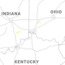
Kentucky
| Local Time | Report Details |
|---|---|
| 7:35 PM CST | Ping Pong Ball sized hail reported near Paducah, KY, 50.3 miles ESE of Cape Girardeau, MO, most hail was dimed size largest was 1.5 inches. |
| 3:30 AM CST | Report from mping: trees uprooted or snapped; roof blown of in graves county KY, 32 miles N of Mc Kenzie, TN |
| 3:41 AM CST | Tree downed onto a house on crossland roa in calloway county KY, 31 miles NNE of Mc Kenzie, TN |
| 3:50 AM CST | Significant tree and powerline damage reported along and near highway 280 two to three miles east of murray. possible tornad in calloway county KY, 37 miles NNE of Mc Kenzie, TN |
| 6:30 AM EST | Powerlines are down around scott county... ky. due to this... the scott county schools have been closed for toda in scott county KY, 52.4 miles NW of Irvine, KY |
Oklahoma
| Local Time | Report Details |
|---|---|
| 8:19 PM CST | Storm damage reported in tulsa county OK, 0.2 miles E of Tulsa, OK |
| 8:25 PM CST | Quarter sized hail reported near Tulsa, OK, 4.3 miles ESE of Tulsa, OK, quarter size hail near us 412 and 49th w ave. |
| 8:40 PM CST | Quarter sized hail reported near Tulsa, OK, 6.7 miles ENE of Tulsa, OK |
| 9:05 PM CST | Golf Ball sized hail reported near Vinita, OK, 52.4 miles ENE of Tulsa, OK, time estimated from radar. |
| 9:10 PM CST | Quarter sized hail reported near Bixby, OK, 15.8 miles SSE of Tulsa, OK |
| 9:11 PM CST | Golf Ball sized hail reported near Broken Arrow, OK, 14.2 miles SE of Tulsa, OK, dime to quarter size hail. |
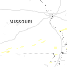
Missouri
| Local Time | Report Details |
|---|---|
| 9:48 PM CST | Quarter sized hail reported near Vanzant, MO, 57 miles ESE of Springfield, MO |
| 9:57 PM CST | Golf Ball sized hail reported near Blue Eye, MO, 48.6 miles S of Springfield, MO |
| 10:03 PM CST | Quarter sized hail reported near Branson, MO, 42 miles S of Springfield, MO |
| 10:10 PM CST | Half Dollar sized hail reported near Blue Eye, MO, 48.6 miles S of Springfield, MO |
| 10:14 PM CST | Half Dollar sized hail reported near Branson, MO, 42 miles S of Springfield, MO |
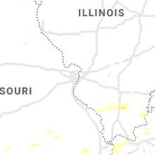
Illinois
| Local Time | Report Details |
|---|---|
| 10:25 PM CST | Roof damage to building ... says roof blown off bathroom at a stadium/par in jackson county IL, 42.8 miles NNE of Cape Girardeau, MO |
| 10:25 PM CST | Mesonet station up809 3.6 se grand tower (upr in jackson county IL, 21 miles NNE of Cape Girardeau, MO |
| 10:27 PM CST | Trees and powerlines down in west frankfort... some of downed trees caused structural damage to homes and blocked roads. time estimate in franklin county IL, 52.9 miles NE of Cape Girardeau, MO |
| 10:43 PM CST | Storm damage reported in union county IL, 18.2 miles NE of Cape Girardeau, MO |
| 10:45 PM CST | Trees and powerlines dow in jackson county IL, 34.1 miles NNE of Cape Girardeau, MO |
Connect with Interactive Hail Maps