

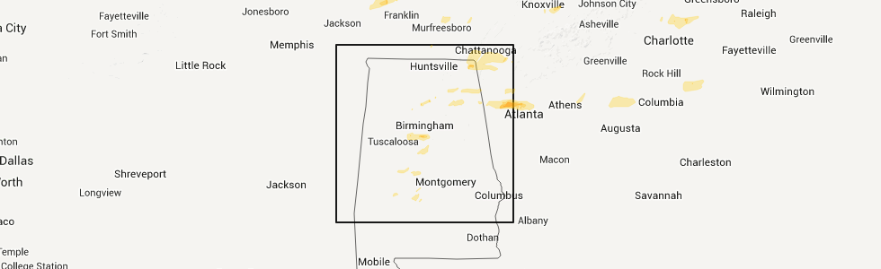
Hail Map for Monday, February 28, 2011
Number of Impacted Households on 2/28/2011
0
Impacted by 1" or Larger Hail
0
Impacted by 1.75" or Larger Hail
0
Impacted by 2.5" or Larger Hail
Square Miles of Populated Area Impacted on 2/28/2011
0
Impacted by 1" or Larger Hail
0
Impacted by 1.75" or Larger Hail
0
Impacted by 2.5" or Larger Hail


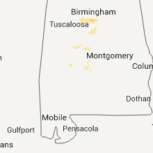

Cities Most Affected by Hail Storms of 2/28/2011
| Hail Size | Demographics of Zip Codes Affected | ||||||
|---|---|---|---|---|---|---|---|
| City | Count | Average | Largest | Pop Density | House Value | Income | Age |
| Birmingham, AL | 1 | 1.75 | 1.75 | 1155 | $37k | $7.6k | 37.3 |
| Morris, AL | 1 | 1.75 | 1.75 | 208 | $118k | $44.3k | 42.0 |
| Cullman, AL | 1 | 1.75 | 1.75 | 160 | $92k | $35.7k | 39.3 |
Hail and Wind Damage Spotted on 2/28/2011
Filter by Report Type:Hail ReportsWind Reports
States Impacted
Kentucky, Ohio, Tennessee, Pennsylvania, West Virginia, Indiana, Missouri, Illinois, Alabama, Maryland, North Carolina, Georgia, South CarolinaKentucky
| Local Time | Report Details |
|---|---|
| 12:00 PM UTC | Power outages were reported in calaboos in wolfe county KY, 25 miles ENE of Irvine, KY |
| 12:00 PM UTC | Estil county em relayed report of numerous trees blown down around the county between about 7 and 10 a.m. 4 to 5 thousand people were without power during the morning h in estill county KY, 0.3 miles E of Irvine, KY |
| 12:00 PM UTC | Trees were blown down on winchester road just north of the town of palmer on the estill clark county lin in estill county KY, 9.2 miles NW of Irvine, KY |
| 12:14 PM UTC | Powell county em relayed numerous reports of large trees down and several out buildings damaged or had roofs blown off around the hardwick creek are in powell county KY, 5.8 miles NNE of Irvine, KY |
| 12:20 PM UTC | Reports of trees down in county in carter county KY, 70.8 miles NE of Irvine, KY |
| 12:22 PM UTC | Power outages around the county. numerous reports of trees down throughout the count in estill county KY, 0.3 miles E of Irvine, KY |
| 12:22 PM UTC | Trees down in boyd county KY, 54.5 miles W of Charleston, WV |
| 12:25 PM UTC | Roof off part of a home on beech street. included photo on wsaz web sit in boyd county KY, 54.9 miles W of Charleston, WV |
| 12:25 PM UTC | Tree of greater than 12 inch diameter blown down onto power lines blocking highway 715 just south of roger in wolfe county KY, 18.5 miles E of Irvine, KY |
| 12:30 PM UTC | Trees were blown down on hwy 1010 in tolive in wolfe county KY, 29.2 miles ENE of Irvine, KY |
| 12:30 PM UTC | Quarter sized hail reported near Campton, KY, 23.4 miles E of Irvine, KY |
| 12:33 PM UTC | Several houses along landsaw road with tin roofing damaged. also several trees knocked over from thunderstorm winds along the mountain parkway in wolfe county KY, 28.9 miles E of Irvine, KY |
| 12:35 PM UTC | Kentucky mesonet measured a peak wind gust of 59 mp in cumberland county KY, 84.2 miles S of Louisville, KY |
| 12:35 PM UTC | Power outages were reported in calaboos in wolfe county KY, 25 miles ENE of Irvine, KY |
| 12:35 PM UTC | Large trees down on ky 1010 and along the mountain parkway from thunderstorm wind in wolfe county KY, 31.6 miles E of Irvine, KY |
| 12:37 PM UTC | Overhang porch and pieces of siding torn off a mobile hom in wolfe county KY, 33.2 miles E of Irvine, KY |
| 12:38 PM UTC | A spotter reported that his lawn furniture was being blown around by thunderstorm wind gusts 3 miles south of canel city. pea size hail was also falling when the report in morgan county KY, 39.8 miles ENE of Irvine, KY |
| 12:40 PM UTC | Tree branches the size of a persons arm were being blown down in the community of pulaski south of euban in pulaski county KY, 49.8 miles SW of Irvine, KY |
| 12:45 PM UTC | The lee county superintendent reported that all of the shools county wide were without power due to thunderstorm wind gust in lee county KY, 16.7 miles ESE of Irvine, KY |
| 12:45 PM UTC | The pulaski county emergency manager received numerous reports of downed trees and structural damage from around the county. reports were received of shingles being blo in pulaski county KY, 55.2 miles SW of Irvine, KY |
| 12:49 PM UTC | Several large trees down or snapped along the mountain parkway near mile marker 6 in magoffin county KY, 44.3 miles E of Irvine, KY |
| 12:54 PM UTC | One double wide trailer was blown over and had roof blown off. one single wide trailer had most of its roof blown off. one large apple tree was uprooted. the damage hap in magoffin county KY, 45.9 miles E of Irvine, KY |
| 1:00 PM UTC | One trailer blow over within the city limits of salyersvill in magoffin county KY, 50.2 miles E of Irvine, KY |
| 1:00 PM UTC | One tree was blown down on ky highway 30. the time is based on radar estimat in breathitt county KY, 44.7 miles E of Irvine, KY |
| 1:15 PM UTC | Numerous reports of trees down around the county including talbert and jackso in breathitt county KY, 34 miles ESE of Irvine, KY |
| 1:15 PM UTC | The pulaski county emergency manager received numerous reports of downed trees and structural damage from around the county. reports were received of shingles being blo in pulaski county KY, 55.2 miles SW of Irvine, KY |
| 1:30 PM UTC | Wind damage occurred to a house and a building on sweet hollow golf course. a mobile home was damaged when a tree fell on i in laurel county KY, 50.9 miles S of Irvine, KY |
| 1:35 PM UTC | Trees down and one barn blown down on buffalo branch road in corbin in knox county. one rv was also reported blown over in this locatio in knox county KY, 52.7 miles S of Irvine, KY |
| 1:35 PM UTC | Trees down and the roof of a barn was blown off on buffalo branch road in corbin in knox county. one rv was also reported blown over in this locatio in knox county KY, 52.7 miles S of Irvine, KY |
| 1:53 PM UTC | Quarter sized hail reported near Pikeville, KY, 63.3 miles NNW of Bristol, TN, quarter sized hail was reported in pikeville. |
| 2:00 PM UTC | Quarter sized hail reported near Strunk, KY, 53.1 miles NNW of Knoxville, TN |
| 2:20 PM UTC | Hwy 160 closed temporarily due to a tree across the roa in letcher county KY, 55.8 miles NW of Bristol, TN |
| 2:32 PM UTC | Numerous reports of trees down throughout the count in leslie county KY, 49.9 miles SE of Irvine, KY |
| 2:35 PM UTC | One 8 foot by 12 foot shed was moved about 40 feet by wind. a few shingles and some siding was torn off one structure. also an unsupported concrete block wall was knock in bell county KY, 46.2 miles NNE of Knoxville, TN |
| 6:30 PM UTC | Numerous reports of trees down around the county including talbert and jackso in breathitt county KY, 34 miles ESE of Irvine, KY |
| 10:15 AM UTC | Several trees downed near fall of rough. two downed trees blocked rolling stone acres lane and kiper-whitworth roa in breckinridge county KY, 52.5 miles WSW of Louisville, KY |
Ohio
| Local Time | Report Details |
|---|---|
| 12:00 PM UTC | A small barn... several trees and minor roof damage to 2 homes south of state route 50 on county road 12 in vinton county OH, 65.4 miles SSE of Columbus, OH |
| 12:03 PM UTC | Tree downe in scioto county OH, 74.9 miles WNW of Charleston, WV |
| 12:08 PM UTC | Tree downe in scioto county OH, 70.6 miles WNW of Charleston, WV |
| 12:15 PM UTC | Several trees down including a tree down over power lines in jackson county OH, 66 miles SSE of Columbus, OH |
| 12:15 PM UTC | Tree down on dazell rd on rt 821 in washington county OH, 74.5 miles N of Charleston, WV |
| 12:15 PM UTC | Tree down on dazell road on rt 821 town of vincent in washington county OH, 70.4 miles N of Charleston, WV |
| 12:15 PM UTC | Tree down on house in vincent in washington county OH, 70.4 miles N of Charleston, WV |
| 12:15 PM UTC | Tree down on rt 821 at dazell road in town of whipple in washington county OH, 83.4 miles N of Charleston, WV |
| 12:20 PM UTC | Multiple trees down. some power outage in athens county OH, 65 miles SE of Columbus, OH |
| 12:25 PM UTC | Tree down in town of dart in washington county OH, 80.2 miles NNE of Charleston, WV |
| 12:30 PM UTC | Power lines down near guysville. trees down throughout county in athens county OH, 68.5 miles NNW of Charleston, WV |
Tennessee
| Local Time | Report Details |
|---|---|
| 12:15 PM UTC | Sheriff dispatch relayed rpt of downed power lines from school bus drive in stewart county TN, 44.9 miles ENE of Mc Kenzie, TN |
| 12:20 PM UTC | Benton s.o. reported several locations in central benton county with trees blown dow in benton county TN, 26.3 miles E of Mc Kenzie, TN |
| 12:45 PM UTC | Quarter sized hail reported near Cumberland Furnace, TN, 32.7 miles WNW of Nashville, TN, quarter size hail reported in cumberland furnace. |
| 3:15 PM UTC | 1 tree down near junction of hwy 27 and hwy 2 in morgan county TN, 35.9 miles W of Knoxville, TN |
| 4:30 PM UTC | Spotter reports at 3728 fredonia road...trees and powerlines down. debris in fence. no structural damage observe in coffee county TN, 56.6 miles NW of Chattanooga, TN |
| 4:45 PM UTC | Roof blown off barn at the intersection of carlyle avenue and cedar creek roa in hamblen county TN, 45.1 miles ENE of Knoxville, TN |
| 5:48 PM UTC | Few trees dow in anderson county TN, 14.7 miles NW of Knoxville, TN |
| 6:10 PM UTC | Two trees and power lines down in the pittman center are in sevier county TN, 32.8 miles ESE of Knoxville, TN |
| 6:45 PM UTC | Trees and powerlines down in elora near borderline r in lincoln county TN, 59.6 miles W of Chattanooga, TN |
| 7:00 PM UTC | Few trees dow in marion county TN, 18.2 miles W of Chattanooga, TN |
| 7:25 PM UTC | Few trees down near intersection of hooker and wilson road in hamilton county TN, 3.2 miles ENE of Chattanooga, TN |
| 7:30 PM UTC | Few trees down on a hous in hamilton county TN, 4.5 miles NNE of Chattanooga, TN |
| 7:30 PM UTC | Numerous reports of trees and power lines down across across roadways and house in hamilton county TN, 4.5 miles NNE of Chattanooga, TN |
| 7:30 PM UTC | Numerous trees and power lines down and 8 homes with damage ranging from minor to major between signal mountain and redban in hamilton county TN, 6 miles NNW of Chattanooga, TN |
| 7:40 PM UTC | Two trees dow in rhea county TN, 35 miles NNE of Chattanooga, TN |
| 7:40 PM UTC | Few trees and a flag pole dow in bradley county TN, 29.4 miles ENE of Chattanooga, TN |
| 7:45 PM UTC | Quarter sized hail reported near Cleveland, TN, 26.5 miles ENE of Chattanooga, TN |
| 8:00 PM UTC | *** 1 fatal *** 1 fatality reported 10 miles south of benton in the old fort area on ladd springs rd. tree fell on a mobile home and killed a 75 year old ma in polk county TN, 37.4 miles E of Chattanooga, TN |
| 8:05 PM UTC | Numerous trees down in relianc in polk county TN, 43 miles ENE of Chattanooga, TN |
| 8:05 PM UTC | Numerous trees and power lines down in ocoe in polk county TN, 35.7 miles E of Chattanooga, TN |
| 8:05 PM UTC | Numerous trees and power lines dow in polk county TN, 35.3 miles E of Chattanooga, TN |
Pennsylvania
| Local Time | Report Details |
|---|---|
| 12:30 PM UTC | Several trees down in chartiers township in washington county PA, 17.2 miles SW of Pittsburgh, PA |
| 12:30 PM UTC | Trees down on onramp to highway 19 in north strabane township in washington county PA, 16.5 miles SSW of Pittsburgh, PA |
| 1:00 PM UTC | Trees down on pleasant valley road in fayette county PA, 36 miles SE of Pittsburgh, PA |
| 1:00 PM UTC | Trees down on cole road in fayette county PA, 46 miles SSE of Pittsburgh, PA |
| 1:10 PM UTC | Trees down in washington county PA, 25.8 miles S of Pittsburgh, PA |
| 1:13 PM UTC | 1 medium tree down on race track road. in north strabane townshi in washington county PA, 17 miles SSW of Pittsburgh, PA |
| 2:15 PM UTC | 15 to 20 trees dow in bedford county PA, 66.6 miles SSW of State College, PA |
West Virginia
| Local Time | Report Details |
|---|---|
| 12:30 PM UTC | Tree down. roof on barn damage in wood county WV, 56.2 miles N of Charleston, WV |
| 12:30 PM UTC | Barn roof damage in wood county WV, 57.7 miles N of Charleston, WV |
| 12:58 PM UTC | Storm damage reported in cabell county WV, 27.5 miles W of Charleston, WV |
| 12:58 PM UTC | Storm damage reported in cabell county WV, 27.7 miles WNW of Charleston, WV |
| 12:58 PM UTC | Trees dow in cabell county WV, 27.5 miles W of Charleston, WV |
| 12:58 PM UTC | Trees down in cabell county WV, 27.7 miles WNW of Charleston, WV |
| 1:05 PM UTC | Several trees down along rt. 1 in lincoln county WV, 33.4 miles WSW of Charleston, WV |
| 1:15 PM UTC | Aluminum building blown over in harrison county WV, 40.4 miles NW of Elkins, WV |
| 1:30 PM UTC | Numerous trees down in clarksburg in harrison county WV, 35.8 miles NW of Elkins, WV |
| 1:30 PM UTC | Roof partly blown off in kanawha county WV, 4.8 miles SW of Charleston, WV |
| 1:35 PM UTC | Trees and powerlines down on oliver street in charleston in kanawha county WV, 0.5 miles E of Charleston, WV |
| 1:37 PM UTC | Storm damage reported in kanawha county WV, 3 miles NE of Charleston, WV |
| 2:00 PM UTC | Iflows braxton co communication tower blown ove in braxton county WV, 48.4 miles ENE of Charleston, WV |
| 2:05 PM UTC | Roof blown off fire station radio tower. multiple trees dow in braxton county WV, 49.6 miles WSW of Elkins, WV |
| 2:05 PM UTC | Trees down in fayette county WV, 26.9 miles SE of Charleston, WV |
| 2:05 PM UTC | Quarter sized hail reported near Williamson, WV, 56.4 miles SW of Charleston, WV |
| 2:07 PM UTC | Trees down in park in fayette county WV, 32.9 miles ESE of Charleston, WV |
| 2:15 PM UTC | Numerous trees down in nicholas county WV, 47.5 miles E of Charleston, WV |
| 2:15 PM UTC | Numerous trees down in nicholas county WV, 44.1 miles ESE of Charleston, WV |
| 2:20 PM UTC | Numerous trees down in nicholas county WV, 52.4 miles E of Charleston, WV |
| 2:30 PM UTC | Trees down on rt.2 in greenbrier county WV, 54.9 miles ESE of Charleston, WV |
| 2:30 PM UTC | Multiple trees down in webster springs and throughout county. numerous power outage in webster county WV, 43.3 miles SW of Elkins, WV |
| 2:30 PM UTC | Quarter sized hail reported near Gilbert, WV, 52.6 miles SSW of Charleston, WV, quarter size hail covering ground |
| 2:50 PM UTC | Trees down along rt 219 near hillsboro in pocahontas county WV, 58.2 miles SSW of Elkins, WV |
| 3:10 PM UTC | Trees down on black diamond rd in mcdowell county WV, 65 miles NE of Bristol, TN |
| 3:10 PM UTC | Tree down coretta coalwood mountain in mcdowell county WV, 59.1 miles NNE of Bristol, TN |
| 3:14 PM UTC | Storm damage reported in pendleton county WV, 24.8 miles SSE of Elkins, WV |
| 3:43 PM UTC | Storm damage reported in pendleton county WV, 24.8 miles SSE of Elkins, WV |
Indiana
| Local Time | Report Details |
|---|---|
| 12:53 PM UTC | Part of roof torn off house. swing set blown across yar in hamilton county IN, 15.8 miles NE of Indianapolis, IN |
Missouri
| Local Time | Report Details |
|---|---|
| 1:17 PM UTC | On christopher dr... large older tree down partially blocking road... and a car port blown over and collapsed. this damage viewed enroute to work this mornin in st. louis county MO, 14.5 miles SSW of Saint Louis, MO |
| 2:16 PM UTC | Numerous 4 to 5 inch diamter limbs down... est 2 foot diameter tree branch dow in st. louis county MO, 10.4 miles NNW of Saint Louis, MO |
| 2:25 PM UTC | Smaller trees uprooted... shingles torn off house in pike county MO, 60.1 miles ENE of Columbia, MO |
| 11:06 PM UTC | Large pine tree 35 to 40 foot tall uprooted. also one storage shed overturne in st. louis county MO, 16.2 miles SSW of Saint Louis, MO |
Illinois
| Local Time | Report Details |
|---|---|
| 1:41 PM UTC | Est. 70mph winds... half inch tree limbs down in st. clair county IL, 9.3 miles ESE of Saint Louis, MO |
| 1:45 PM UTC | Parts of a barn roof and siding...a flattened shed...and a vehicle 20 plus yards off the roadway off of county road 21 near kuhn station roa in madison county IL, 20.2 miles ENE of Saint Louis, MO |
| 1:46 PM UTC | East of i-55....on stauton rd one half mile south of goshen...old barn flattened...large debris field in madison county IL, 17.2 miles NE of Saint Louis, MO |
| 4:33 PM UTC | Most homes damaged near intersection of 40 and 143... holes in siding... trees blown dow in madison county IL, 29.1 miles ENE of Saint Louis, MO |
Alabama
| Local Time | Report Details |
|---|---|
| 5:43 PM UTC | Roof peeled off bar in limestone county AL, 45.4 miles E of Florence, AL |
| 5:46 PM UTC | Three large trees cause damage to awning at colbert county high schoo in colbert county AL, 11.7 miles SE of Florence, AL |
| 5:46 PM UTC | Roof damage to mobile home near us 72 on sledge rd. other structural damage reported along with several power lines dow in limestone county AL, 30.4 miles E of Florence, AL |
| 6:02 PM UTC | Roof damage...and trees downed on poplar creek rd west of athens in limestone county AL, 31.7 miles E of Florence, AL |
| 6:08 PM UTC | Power outages near the intersection of snake rd and parker r in limestone county AL, 31.7 miles E of Florence, AL |
| 6:37 PM UTC | Reported power lines down on robert strong dr and baltimore hill rd in moores mill community. time estimated by rada in madison county AL, 64.6 miles E of Florence, AL |
| 6:42 PM UTC | Damage to barns and multiple trees down around hazel green in north madison count in madison county AL, 65.7 miles E of Florence, AL |
| 6:45 PM UTC | Several roof shingles were torn off by thunderstorm wind in madison county AL, 66.8 miles WSW of Chattanooga, TN |
| 6:50 PM UTC | Damage to building on hwy 7 in madison county AL, 53.8 miles E of Florence, AL |
| 7:21 PM UTC | Two trees were knocked down on college street in scottsboro. time estimated by rada in jackson county AL, 48.5 miles WSW of Chattanooga, TN |
| 7:33 PM UTC | Reported several trees down across ara in marshall county AL, 58 miles NNE of Birmingham, AL |
| 7:43 PM UTC | Several power lines down across sunset dr and lurleen b wallace d in marshall county AL, 64.6 miles NNE of Birmingham, AL |
| 7:47 PM UTC | Several trees down across guntersville state par in marshall county AL, 65.2 miles NNE of Birmingham, AL |
| 7:59 PM UTC | Several trees down across cr 81 in dekalb county AL, 22.7 miles SW of Chattanooga, TN |
| 8:05 PM UTC | Trees down at duck springs elementar in etowah county AL, 63.3 miles NE of Birmingham, AL |
| 8:11 PM UTC | Quarter sized hail reported near Fort Payne, AL, 47.7 miles SSW of Chattanooga, TN, quarter size hail reported on fruit farm rd east of fort payne. |
| 8:11 PM UTC | Quarter sized hail reported near Gadsden, AL, 59.2 miles NE of Birmingham, AL, quarter size hail reported in plesant hill area. |
| 8:11 PM UTC | Quarter sized hail reported near Fort Payne, AL, 51.2 miles SW of Chattanooga, TN, quarter size hail reported in pleasant hill area. |
| 8:13 PM UTC | Trees were blown dow in etowah county AL, 59.9 miles NE of Birmingham, AL |
| 8:21 PM UTC | Trees were blown dow in etowah county AL, 59.9 miles NE of Birmingham, AL |
| 8:25 PM UTC | Trees down at duck springs elementar in etowah county AL, 63.3 miles NE of Birmingham, AL |
| 8:25 PM UTC | Trees down and tin blown off roo in etowah county AL, 68.6 miles SSW of Chattanooga, TN |
| 8:26 PM UTC | Large old oak tree was blown down onto a hom in shelby county AL, 28.4 miles S of Birmingham, AL |
| 8:30 PM UTC | Trees down in etowah county AL, 58.5 miles NE of Birmingham, AL |
| 8:30 PM UTC | Trees downm and minor roof damage to a garage roo in etowah county AL, 58.5 miles NE of Birmingham, AL |
| 8:30 PM UTC | Roof off barn on blackwell roa in etowah county AL, 68.6 miles SSW of Chattanooga, TN |
| 8:35 PM UTC | Barn collapse off county road 167 and possible home damage in the same area. no injurie in cherokee county AL, 65.2 miles SSW of Chattanooga, TN |
| 8:35 PM UTC | Barn collapse off county road 167 and possible home damage in the same area. trees were also blown down in the area. no injurie in cherokee county AL, 65.2 miles SSW of Chattanooga, TN |
| 8:35 PM UTC | Barn collapse off county road 7 with possible injurie in cherokee county AL, 65.2 miles SSW of Chattanooga, TN |
| 8:39 PM UTC | Golf Ball sized hail reported near Cullman, AL, 49.4 miles N of Birmingham, AL, golf ball size hail reported near antioch. |
| 8:40 PM UTC | Trees were blown down in centre.a few trees landed on homes. one auto accident occurred as a vehicle was blown around in the high wind. no injurie in cherokee county AL, 65.1 miles SSW of Chattanooga, TN |
| 8:40 PM UTC | Trees were blown down in centr in cherokee county AL, 65.1 miles SSW of Chattanooga, TN |
| 8:40 PM UTC | Trees were blown down in centre. one auto accident occurred as a vehicle was blown around in the high wind. no injurie in cherokee county AL, 65.1 miles SSW of Chattanooga, TN |
| 8:41 PM UTC | Golf Ball sized hail reported near Morris, AL, 15.8 miles N of Birmingham, AL, hail up to the size of golf balls |
| 8:45 PM UTC | Trees down. walkers chapel road and laceys chapel rao in jefferson county AL, 6.9 miles N of Birmingham, AL |
| 8:55 PM UTC | Metal flagpole snapped in hal in cherokee county AL, 62.7 miles S of Chattanooga, TN |
| 9:00 PM UTC | Quarter sized hail reported near Birmingham, AL, 0.9 miles NE of Birmingham, AL, in avondale area. |
| 9:01 PM UTC | Golf Ball sized hail reported near Birmingham, AL, 0.9 miles NE of Birmingham, AL, hail as large as golf balls on red mountain. |
| 9:05 PM UTC | Ping Pong Ball sized hail reported near Chelsea, AL, 15.9 miles SE of Birmingham, AL, hail as large as ping pong balls in brook highland. |
| 9:26 PM UTC | Large old oak tree was blown down onto a hom in shelby county AL, 28.4 miles S of Birmingham, AL |
| 9:36 PM UTC | Tree down at highway 25 at low road and myrtlewood driv in shelby county AL, 25.7 miles ESE of Birmingham, AL |
| 9:36 PM UTC | At least 5 trees were either snapped off or uprooted near vincent. some tree damage also occurred near vincent elementary school and one tree was blown down at highway in shelby county AL, 26.2 miles ESE of Birmingham, AL |
| 9:45 PM UTC | Trees were blown down in fort mcclella in calhoun county AL, 60.5 miles ENE of Birmingham, AL |
| 9:50 PM UTC | Power line down between alabama highway 21 and bullocks ferry road in talladega county AL, 35.9 miles ESE of Birmingham, AL |
| 9:50 PM UTC | Multiple power lines down around tow in calhoun county AL, 58.6 miles E of Birmingham, AL |
| 9:50 PM UTC | Trees and power lines were blown down around tow in calhoun county AL, 58.6 miles E of Birmingham, AL |
| 9:50 PM UTC | Power pole down on george douthit drive in calhoun county AL, 63.8 miles ENE of Birmingham, AL |
| 9:50 PM UTC | Power pole down on george douthit drive. trees were also blown down in the are in calhoun county AL, 63.8 miles ENE of Birmingham, AL |
| 9:50 PM UTC | Trees and power lines down near cedar springs roa in calhoun county AL, 60 miles ENE of Birmingham, AL |
| 10:22 PM UTC | Trees were blown dow in clay county AL, 47.6 miles SE of Birmingham, AL |
| 10:22 PM UTC | Trees were blown down in the shinbone are in clay county AL, 56.8 miles NNW of Auburn, AL |
| 10:30 PM UTC | Trees dow in clay county AL, 50.8 miles NNW of Auburn, AL |
| 11:15 PM UTC | Mobile homes damaged at county road 104 and county road 107 north of central alabama electric bridg in autauga county AL, 56.5 miles W of Auburn, AL |
| 11:18 PM UTC | Trees down on jackson road and also on mercer roa in elmore county AL, 49.1 miles W of Auburn, AL |
| 11:18 PM UTC | Trees down and mobile home overturned at harris and chad roads. no injuries in elmore county AL, 51.3 miles W of Auburn, AL |
| 11:20 PM UTC | Possible tornado. highway 31 and county road 107 north of prattville. trees and powerlines down. trees on home in autauga county AL, 57.4 miles W of Auburn, AL |
| 11:29 PM UTC | Several trees were blown down along cr160 north of lafayette. at least 6 homes suffered roof damage and several autos were damaged by fallen trees. possible tornad in chambers county AL, 28 miles N of Auburn, AL |
| 11:45 PM UTC | 18-wheeler overturned on interstate 65 near pintlala exi in lowndes county AL, 51.5 miles ENE of Camden, AL |
| 11:50 PM UTC | Trees and powerlines down at county road 37 and deer trail road. a few vehicles overt in lowndes county AL, 48.7 miles ENE of Camden, AL |
| 11:50 PM UTC | Trees and powerlines down at county road 37 and deer trail roa in lowndes county AL, 48.7 miles ENE of Camden, AL |
| 12:28 AM UTC | Several trees and power lines reported down in the davisville community on us highway 29 in macon county AL, 22.1 miles SSW of Auburn, AL |
| 12:54 AM UTC | Three trees reported down at the intersection of dusty road and sandfort road...with one large tree blocking the roadwa in russell county AL, 22.9 miles SE of Auburn, AL |
| 1:36 AM UTC | Trees down and blocking roadway...via ema in barbour county AL, 60.9 miles S of Auburn, AL |
Maryland
| Local Time | Report Details |
|---|---|
| 5:51 PM UTC | Tree on power lines blocking rt 4 n of prince frederick in calvert county MD, 51.1 miles S of Baltimore, MD |
North Carolina
| Local Time | Report Details |
|---|---|
| 7:00 PM UTC | Possible microburst downed trees 10 to 12 inches in diamter at the grandfather mountain community c in watauga county NC, 38.8 miles SE of Bristol, TN |
| 8:00 PM UTC | Quarter sized hail reported near Dobson, NC, 75 miles SSW of Roanoke, VA, quarter size hail covered the ground on trade lane. |
| 8:40 PM UTC | 2 trees reported down off hwy 28 just south of almon in swain county NC, 49 miles SSE of Knoxville, TN |
| 8:48 PM UTC | Trees and power lines down in swain county NC, 45.2 miles SE of Knoxville, TN |
| 8:52 PM UTC | Trees and power lines down in southern alark in swain county NC, 50 miles SSE of Knoxville, TN |
| 9:12 PM UTC | 1.5 to 2 mile wide swath of wind damage in glenwood. trees down on houses and car in mcdowell county NC, 64.2 miles NNE of Greenville, SC |
| 9:14 PM UTC | Media reports several trees blown down on bethel rd...some on home in burke county NC, 58.6 miles NW of Charlotte, NC |
| 9:35 PM UTC | Broadcast media reported several homes damaged by falling trees on the west side of lookout shoals lak in catawba county NC, 41 miles NNW of Charlotte, NC |
| 9:38 PM UTC | 2 trees down on st peters church rd along with pea size hail in catawba county NC, 43.5 miles NNW of Charlotte, NC |
| 9:55 PM UTC | Power line down on jane sower r in iredell county NC, 39.2 miles N of Charlotte, NC |
| 9:55 PM UTC | Trees uprooted and dog house and swingset blown across road in iredell county NC, 39.5 miles N of Charlotte, NC |
| 9:56 PM UTC | Broadcast media reported a sunroom torn off and part of the roof damaged at a home on pilch rd near amity hill rd. trees were blown down in this area as wel in iredell county NC, 33.6 miles N of Charlotte, NC |
| 4:58 PM EST | Quarter sized hail reported near Statesville, NC, 40.7 miles N of Charlotte, NC |
| 10:00 PM UTC | Trees down on house on island ford rd in iredell county NC, 41.8 miles NNW of Charlotte, NC |
| 10:13 PM UTC | Trees down on the south side of town in iredell county NC, 39.2 miles N of Charlotte, NC |
| 10:18 PM UTC | Quarter sized hail reported near Salisbury, NC, 37.9 miles NNE of Charlotte, NC, spotter reported up to 1 inch hail nw of salisbury. |
| 10:18 PM UTC | Davindson co 911 reported tree down on rd in churchland at boones cave rd and s hwy 150 in davidson county NC, 45.7 miles NNE of Charlotte, NC |
| 10:20 PM UTC | Orange co 911 reported tree down in orange grove at bradshaw quarry rd in orange county NC, 33.6 miles WNW of Raleigh, NC |
| 10:25 PM UTC | Large roof blocking statesville blvd near hurley school rd in rowan county NC, 36.9 miles NNE of Charlotte, NC |
| 10:25 PM UTC | Power lines down at satesville blvd and enon chruch rd in rowan county NC, 36.9 miles NNE of Charlotte, NC |
| 10:26 PM UTC | Davidson co 911 reported power line down at hwy 8 and owen rd in davidson county NC, 49.3 miles NE of Charlotte, NC |
| 10:30 PM UTC | Quarter sized hail reported near Lexington, NC, 52 miles NE of Charlotte, NC |
| 10:38 PM UTC | Trees and power lines down in randolph county NC, 65.5 miles NE of Charlotte, NC |
| 10:40 PM UTC | Trees and power lines down in randolph county NC, 67.6 miles NE of Charlotte, NC |
| 10:41 PM UTC | Trees and power lines down in davidson county NC, 50.1 miles NE of Charlotte, NC |
| 10:47 PM UTC | Trees and power lines down in randolph county NC, 56.2 miles ENE of Charlotte, NC |
| 10:47 PM UTC | Davindson co 911 reported tree down on rd in churchland at boones cave rd and s hwy 150 in davidson county NC, 45.7 miles NNE of Charlotte, NC |
| 10:48 PM UTC | Randolph co 911 reported tree down on power line in asheboro at zoo parkway and 220 s in randolph county NC, 63.3 miles ENE of Charlotte, NC |
| 11:20 PM UTC | Trees down in union county NC, 17 miles ESE of Charlotte, NC |
| 12:20 AM UTC | Moore co 911 received report from spotter of trees down off hwy 211 near taylortown in moore county NC, 61.7 miles SW of Raleigh, NC |
Georgia
| Local Time | Report Details |
|---|---|
| 7:30 PM UTC | Walker county 911 relayed reports of downed power lines causing a power outage in rossvill in walker county GA, 4.7 miles SSE of Chattanooga, TN |
| 7:30 PM UTC | Dade county 911 relayed reports of widespread downed trees in and around trento in dade county GA, 16.7 miles SW of Chattanooga, TN |
| 7:30 PM UTC | Dade county emergency management reports widespread tree damage in north dade county. includes damage to 2 houses along highway 299 and in the pinecrest subdivision fro in dade county GA, 7.8 miles SW of Chattanooga, TN |
| 7:30 PM UTC | Quarter sized hail reported near Rossville, GA, 4.7 miles SSE of Chattanooga, TN, walker county 911 relayed reports of quarter sized hail around rossville. |
| 7:42 PM UTC | Catoosa county 911 relayed reports of 3-4 trees dow in catoosa county GA, 15.2 miles SE of Chattanooga, TN |
| 8:00 PM UTC | Whitfield county 911 relayed report of 2 downed trees on houses in cohutt in whitfield county GA, 21.2 miles ESE of Chattanooga, TN |
| 8:00 PM UTC | Whitfield county emergency management reports several trees down on highway 71 just south of the georgia-tennessee borde in whitfield county GA, 22 miles ESE of Chattanooga, TN |
| 8:10 PM UTC | Murray county 911 relayed reports of 3 downed trees on highway 411 in northern murray count in murray county GA, 32.6 miles E of Chattanooga, TN |
| 8:10 PM UTC | Walker county emergency management relayed reports of over a dozen trees downed between chickamauga and rock spring in walker count in walker county GA, 14.5 miles S of Chattanooga, TN |
| 8:10 PM UTC | Quarter sized hail reported near Chickamauga, GA, 14.6 miles SSE of Chattanooga, TN, emergency management in walker county reported quarter-sized hail between chickamagua and rock spring. |
| 8:30 PM UTC | Fannin county 911 relayed reports of over 20 downed trees and 5 downed powerlines in the count in fannin county GA, 57.6 miles ESE of Chattanooga, TN |
| 8:44 PM UTC | Union county 911 relayed reports of over 20 trees down and 5 power lines down across the count in union county GA, 74.5 miles S of Knoxville, TN |
| 8:44 PM UTC | Towns county 911 relayed reports of over 9 trees downed in the county. traffic lights were also reported ou in towns county GA, 66.4 miles W of Greenville, SC |
| 8:45 PM UTC | The union county 911 center reports 3 power lines dow in union county GA, 74.5 miles S of Knoxville, TN |
| 9:00 PM UTC | Bartow county ema relayed a report of many trees down in adairsvill in bartow county GA, 51.4 miles SSE of Chattanooga, TN |
| 9:15 PM UTC | Polk county 911 relayed a reports of a downed tree on highway 100 in cedartow in polk county GA, 52.6 miles WNW of Atlanta, GA |
| 9:15 PM UTC | Several trees down from sky valley southward in rabun county GA, 40.1 miles W of Greenville, SC |
| 9:15 PM UTC | Public reported a flagpole snapped by strong winds west of cave spring near the georgia-alabama borde in floyd county GA, 64.2 miles WNW of Atlanta, GA |
| 9:15 PM UTC | Half Dollar sized hail reported near Roswell, GA, 18.8 miles N of Atlanta, GA, spotter reported 1.25 inch diameter hail in roswell. |
| 9:35 PM UTC | Bartow county ema relayed a report of many trees down in the cartersville are in bartow county GA, 37.4 miles NW of Atlanta, GA |
| 9:39 PM UTC | Cherokee county emergency management reported several downed pine tree in cherokee county GA, 39.7 miles N of Atlanta, GA |
| 9:44 PM UTC | Public reported measuring a gust of 62 mph and a wind of 28 mph with an anemometer on the pickens-dawson county lin in dawson county GA, 48.9 miles N of Atlanta, GA |
| 9:48 PM UTC | Cherokee county emergency management reports power outages in most of woodstoc in cherokee county GA, 25.3 miles NNW of Atlanta, GA |
| 4:50 PM EST | Half Dollar sized hail reported near Acworth, GA, 28.1 miles NNW of Atlanta, GA, public reported quarter to half dollar sized hail. |
| 9:53 PM UTC | Amateur radio relayed reports of structure damage. the back wall of a building was blown down on cherokee driv in cherokee county GA, 40.8 miles N of Atlanta, GA |
| 9:54 PM UTC | Cherokee county emergency management relayed reports on 6 downed trees and power lines in woodstoc in cherokee county GA, 25.3 miles NNW of Atlanta, GA |
| 9:55 PM UTC | Half Dollar sized hail reported near Canton, GA, 34.4 miles N of Atlanta, GA, cherokee county emergency management relayed a report of half dollar sized hail. |
| 9:57 PM UTC | Cherokee county emergency management relayed reports downed trees and powerlines south of canto in cherokee county GA, 33 miles N of Atlanta, GA |
| 4:57 PM EST | Quarter sized hail reported near Kennesaw, GA, 22.9 miles NW of Atlanta, GA, trained spotter reported quarter sized hail in kennesaw near i-575 and bells ferry. |
| 10:15 PM UTC | Half Dollar sized hail reported near Roswell, GA, 18.8 miles N of Atlanta, GA, spotter reported 1.25 inch diameter hail in roswell. |
| 10:25 PM UTC | Banks county emergency management reported multiple downed trees. a storage shed and store signs were blown onto us 44 in banks county GA, 61.8 miles SW of Greenville, SC |
| 10:25 PM UTC | Banks county emergency management relayed reports that downtown maysville had power ou in jackson county GA, 58.9 miles NE of Atlanta, GA |
| 10:37 PM UTC | Public reported a couple of trees down in winde in barrow county GA, 42 miles ENE of Atlanta, GA |
| 10:45 PM UTC | The 911 center of gwinnett county reported a tree down on a house in lawrenceville on guardian wa in gwinnett county GA, 27.3 miles ENE of Atlanta, GA |
| 10:52 PM UTC | Madison county 911 relayed reports of widespread tree damage in the county. more than a dozen trees were downe in madison county GA, 60.4 miles SW of Greenville, SC |
| 10:52 PM UTC | Quarter sized hail reported near Smyrna, GA, 8.1 miles NW of Atlanta, GA, public reported quarter sized hail. |
| 11:00 PM UTC | Tree down in hart county GA, 41.9 miles SW of Greenville, SC |
| 11:08 PM UTC | Tree down in goldmine area in hart county GA, 45.2 miles SW of Greenville, SC |
| 11:12 PM UTC | Tree down along highway 172 in hart county GA, 44 miles SSW of Greenville, SC |
| 11:16 PM UTC | Trees down from dewy rose to rockbranch in elbert county GA, 46.3 miles SSW of Greenville, SC |
| 11:20 PM UTC | Metal roof blown off building in elbert county GA, 47.5 miles SSW of Greenville, SC |
| 11:25 PM UTC | Bartow county ema relayed a report of many trees down in adairsvill in bartow county GA, 51.4 miles SSE of Chattanooga, TN |
South Carolina
| Local Time | Report Details |
|---|---|
| 10:01 PM UTC | Two trees blown down and some shingles off a roof near the highway 414 and highway 25 intersection in greenville county SC, 17 miles NNE of Greenville, SC |
| 10:15 PM UTC | Tree on roadway in greenville county SC, 15.1 miles NNE of Greenville, SC |
| 10:19 PM UTC | Tree in roadway in greenville county SC, 17 miles NNE of Greenville, SC |
| 10:20 PM UTC | Roof shingles blown off residence...2 sheds blown into fenc in pickens county SC, 2.4 miles ESE of Greenville, SC |
| 10:30 PM UTC | Trees down in greenville county SC, 13.2 miles NE of Greenville, SC |
| 10:30 PM UTC | Side of a shed blown off...roof of another shed peeled back...and 7 pine trees uprooted off of miller roa in greenville county SC, 17.7 miles E of Greenville, SC |
| 10:35 PM UTC | Tree on road at casey creek rd and cherokee circle in spartanburg county SC, 45.8 miles ENE of Greenville, SC |
| 10:36 PM UTC | Several spotters reported trees and power lines blown down in areas from holly grove rd and foster lake rd just north of blacksburg...east to the antioch communit in cherokee county SC, 37.7 miles W of Charlotte, NC |
| 10:43 PM UTC | Tree on road at south green river rd and hwy 29 in cherokee county SC, 51.7 miles ENE of Greenville, SC |
| 10:50 PM UTC | Spotter reports finding several large limbs down in their yard from the stor in laurens county SC, 31.8 miles ESE of Greenville, SC |
| 11:18 PM UTC | Several large tree limbs blown down in the inman are in spartanburg county SC, 32.7 miles ENE of Greenville, SC |
| 11:30 PM UTC | Spotter reports a tree fell on a house in ware shoals. no injuries. red cross assistin in greenwood county SC, 36.7 miles SE of Greenville, SC |
| 11:35 PM UTC | Trees down all across the county in abbeville county SC, 46.6 miles SSE of Greenville, SC |
| 12:00 AM UTC | Trees down...a few possibly on cars in greenwood county SC, 46.9 miles N of Augusta, GA |
| 12:10 AM UTC | Trees down at riverside rd and porter ranch rd in lancaster county SC, 28.4 miles S of Charlotte, NC |
| 12:18 AM UTC | Trees down in fairfield county SC, 48.2 miles S of Charlotte, NC |
| 12:18 AM UTC | A roof ripped off an out building and numerous trees down along trinity church rd in newberry county SC, 55.3 miles NNE of Augusta, GA |
| 12:24 AM UTC | Trees down in saluda county SC, 43 miles N of Augusta, GA |
| 12:24 AM UTC | Numerous trees down from very intense microburst 2 miles north of silverstree in newberry county SC, 55.3 miles NNE of Augusta, GA |
| 12:24 AM UTC | Trees down in saluda county SC, 41.9 miles N of Augusta, GA |
| 12:30 AM UTC | Trees down in fairfield county SC, 59.8 miles SSW of Charlotte, NC |
| 12:42 AM UTC | Trees down in saluda county SC, 39.7 miles NNE of Augusta, GA |
| 12:42 AM UTC | Trees down in saluda county SC, 33.3 miles NNE of Augusta, GA |
| 12:48 AM UTC | Trees down in edgefield county SC, 26 miles NNE of Augusta, GA |
| 12:50 AM UTC | Trees down throughout county in kershaw county SC, 54.9 miles SSE of Charlotte, NC |
| 1:12 AM UTC | Car accident with a large pine tree down across ousleydale road. no injuries. several other trees down and some homes damaged. possible tornad in darlington county SC, 69.9 miles SE of Charlotte, NC |
| 1:12 AM UTC | Tree down at intersection of ousleydale and tory james roads. time estimated based on radar in darlington county SC, 69.9 miles SE of Charlotte, NC |
| 1:12 AM UTC | Tree down along kellybelle road. time estimated based on radar in darlington county SC, 72.6 miles SSE of Charlotte, NC |
| 1:15 AM UTC | Pieces of sheet metal blew off a building and damaged a vehicl in lexington county SC, 62.4 miles NE of Augusta, GA |
| 1:17 AM UTC | Trees down at centerville and n center road. time estimated based on radar in darlington county SC, 75.8 miles SE of Charlotte, NC |
| 1:21 AM UTC | Multiple wires down on us-52. time estimated based on radar in darlington county SC, 74.7 miles SE of Charlotte, NC |
| 1:31 AM UTC | 1 large pine tree uprooted along highway 95 just north of the sc welcome center. time estimated by rada in dillon county SC, 81.5 miles WNW of Wilmington, NC |
Connect with Interactive Hail Maps