

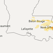
Hail Map for Tuesday, February 7, 2017

Number of Impacted Households on 2/7/2017
0
Impacted by 1" or Larger Hail
0
Impacted by 1.75" or Larger Hail
0
Impacted by 2.5" or Larger Hail
Square Miles of Populated Area Impacted on 2/7/2017
0
Impacted by 1" or Larger Hail
0
Impacted by 1.75" or Larger Hail
0
Impacted by 2.5" or Larger Hail


Cities Most Affected by Hail Storms of 2/7/2017
| Hail Size | Demographics of Zip Codes Affected | ||||||
|---|---|---|---|---|---|---|---|
| City | Count | Average | Largest | Pop Density | House Value | Income | Age |
| Picayune, MS | 2 | 1.88 | 2.00 | 206 | $73k | $28.2k | 38.4 |
| Lake, MS | 1 | 2.00 | 2.00 | 26 | $50k | $25.1k | 36.8 |
| Cadiz, KY | 1 | 1.75 | 1.75 | 45 | $75k | $32.5k | 44.5 |
| Pontotoc, MS | 1 | 1.75 | 1.75 | 75 | $68k | $30.9k | 36.0 |
| Carthage, MS | 1 | 1.75 | 1.75 | 39 | $55k | $27.7k | 35.1 |
| Dauphin Island, AL | 1 | 1.75 | 1.75 | 221 | $139k | $44.4k | 53.0 |
| Lawrence, MS | 1 | 1.75 | 1.75 | 19 | $50k | $33.0k | 40.4 |
Hail and Wind Damage Spotted on 2/7/2017
Filter by Report Type:Hail ReportsWind Reports
Tennessee
| Local Time | Report Details |
|---|---|
| 9:20 AM CST | Emergency manager reported damage to house with carport blown down and damage to windows from debris. multiple trees reported dow in houston county TN, 44.9 miles W of Nashville, TN |
| 9:54 AM CST | One tree reported dow in davidson county TN, 13 miles WSW of Nashville, TN |
| 10:08 AM CST | Tree down in franklin in williamson county TN, 16.8 miles SSW of Nashville, TN |
| 10:10 AM CST | One tree reported dow in davidson county TN, 4.3 miles SE of Nashville, TN |
| 10:16 AM CST | Tree blown down on old glenrose avenue between i-24 and briley parkway in davidson county TN, 4.6 miles SE of Nashville, TN |
Louisiana
| Local Time | Report Details |
|---|---|
| 10:45 AM CST | Ping Pong Ball sized hail reported near Kenner, LA, 10.5 miles W of New Orleans, LA |
Mississippi
| Local Time | Report Details |
|---|---|
| 11:50 AM CST | Quarter sized hail reported near Clinton, MS, 10.1 miles WNW of Jackson, MS |
| 12:07 PM CST | Quarter sized hail reported near Jackson, MS, 2.3 miles NW of Jackson, MS |
| 12:09 PM CST | Quarter sized hail reported near Taylorsville, MS, 54.6 miles SE of Jackson, MS |
| 12:19 PM CST | Quarter sized hail reported near Jackson, MS, 4.3 miles N of Jackson, MS |
| 12:20 PM CST | Quarter sized hail reported near Jackson, MS, 5.2 miles NNE of Jackson, MS, lots of hail on interstate 55 with stones up to quarter size |
| 1:27 PM CST | Half Dollar sized hail reported near Brandon, MS, 12.6 miles NE of Jackson, MS |
| 1:35 PM CST | Half Dollar sized hail reported near Brandon, MS, 15.4 miles ENE of Jackson, MS |
| 1:45 PM CST | Quarter sized hail reported near Brandon, MS, 19.7 miles NE of Jackson, MS, quarter size hail reported near goshen springs. |
| 2:08 PM CST | Golf Ball sized hail reported near Picayune, MS, 46.3 miles NNE of New Orleans, LA, golf ball size near picayune. |
| 2:11 PM CST | Hen Egg sized hail reported near Picayune, MS, 45.7 miles NNE of New Orleans, LA |
| 2:22 PM CST | Half Dollar sized hail reported near Canton, MS, 23.2 miles NNE of Jackson, MS |
| 3:10 PM CST | Quarter sized hail reported near Lena, MS, 33.2 miles NE of Jackson, MS |
| 3:37 PM CST | Golf Ball sized hail reported near Carthage, MS, 56.1 miles SW of Starkville, MS |
| 3:45 PM CST | Ping Pong Ball sized hail reported near Carthage, MS, 54.2 miles SW of Starkville, MS, public reported ping pong ball sized hail 2 miles north of renfroe. |
| 3:56 PM CST | Quarter sized hail reported near Forest, MS, 42.5 miles ENE of Jackson, MS |
| 4:05 PM CST | Ping Pong Ball sized hail reported near Forest, MS, 41.9 miles ENE of Jackson, MS, ping pong sized hail reported by the public a mile east of hillsboro. |
| 4:15 PM CST | Quarter sized hail reported near Carthage, MS, 51.2 miles SSW of Starkville, MS, quarter sized hail reported by the emergency manager four mile northeast of edinburg. |
| 4:26 PM CST | Hen Egg sized hail reported near Lake, MS, 49.8 miles E of Jackson, MS |
| 4:54 PM CST | Golf Ball sized hail reported near Lawrence, MS, 55.8 miles E of Jackson, MS, golf ball hail reported by public via social media. |
| 5:55 PM CST | Quarter sized hail reported near Pachuta, MS, 78.3 miles ESE of Jackson, MS, quarter sized hail reported in pachuta by the emergency manager. |
| 5:55 PM CST | Quarter sized hail reported near Pontotoc, MS, 51.2 miles N of Starkville, MS, along highway 342 in the black zion community. |
| 5:57 PM CST | Golf Ball sized hail reported near Pontotoc, MS, 50.8 miles N of Starkville, MS, hail occurred in the black zion community. report relayed via broadcast media. |
| 6:15 PM CST | Quarter sized hail reported near Shubuta, MS, 85.2 miles W of Camden, AL, quarter sized hail reported by the emergency manager 2 miles west southwest of de soto along county highway 280. |
Alabama
| Local Time | Report Details |
|---|---|
| 1:50 PM CST | Tree down on county road 39 in baldwin county AL, 16.1 miles NE of Mobile, AL |
| 2:50 PM CST | Quarter sized hail reported near Elberta, AL, 33.1 miles SE of Mobile, AL, quarter size hail reported in elberta |
| 2:53 PM CST | *** 1 inj *** extensive wind damage in the area around williamson avenue and marvyn parkway... just south of i-85 in opelika. warehouse building had a large section of in lee county AL, 6 miles E of Auburn, AL |
| 3:24 PM CST | Tree down on house in crestview... fl. timing estimated by rada in mobile county AL, 7.4 miles SW of Mobile, AL |
| 3:26 PM CST | Damage to houses and a campground. also damage to fencing at a baseball field along with tree damag in covington county AL, 64.8 miles N of Miramar Beach, FL |
| 3:55 PM CST | Kjka asos measured 59 mph wind gust in baldwin county AL, 35.2 miles SE of Mobile, AL |
| 4:00 PM CST | Golf Ball sized hail reported near Dauphin Island, AL, 29.6 miles S of Mobile, AL, quarter to golf ball size hail reported on dauphin island. power line also down on the north side of dauphin island bridge near cedar point. |
| 4:15 PM CST | Power lines down in multiple parts of hartfor in geneva county AL, 63.6 miles NE of Miramar Beach, FL |
| 4:15 PM CST | Several houses and businesses damaged. appeared to be caused by straight line wind in geneva county AL, 67.9 miles NE of Miramar Beach, FL |
| 4:30 PM CST | Local media relayed report of damage to home in houston county AL, 75.5 miles NE of Miramar Beach, FL |
Georgia
| Local Time | Report Details |
|---|---|
| 4:00 PM EST | 911 call center reported a tree down on a power line along desert rose roa in bacon county GA, 31.3 miles E of Douglas, GA |
| 4:23 PM EST | Multiple trees and limbs down on structures near us 27 and old moon r in muscogee county GA, 31.8 miles E of Auburn, AL |
| 4:40 PM EST | Multiple trees and power lines down in town of cataula on us 27. some power lines and trees down on vehicles with people insid in harris county GA, 35.8 miles E of Auburn, AL |
| 5:00 PM EST | Tree down on house and car near black creek trai in taylor county GA, 65.6 miles E of Auburn, AL |
| 5:24 PM EST | A couple trees down north of oglethorpe near hwy 12 in macon county GA, 85 miles ESE of Auburn, AL |
| 5:45 PM EST | Roof blown off of house on harrell moye rd in seminole county GA, 58.3 miles NW of Tallahassee, FL |
| 5:45 PM EST | Trees and power lines down across seminole county...large branch fell on car on hagen-still rd in seminole county GA, 51.6 miles NW of Tallahassee, FL |
| 6:25 PM EST | Trees down near hwy 241 near ga-fl border in decatur county GA, 23.8 miles NW of Tallahassee, FL |
| 6:45 PM EST | Trees and power lines down along pine circle sw and 1st st in cairo in grady county GA, 30.6 miles N of Tallahassee, FL |
| 7:00 PM EST | Reports of trees down along hwy 37 in colquitt county GA, 56.6 miles NNE of Tallahassee, FL |
| 7:00 PM EST | Trees down n of 311 on river rd in mitchell county GA, 52.1 miles N of Tallahassee, FL |
| 7:00 PM EST | Reports of trees down along hwy 111 in grady county GA, 42.7 miles N of Tallahassee, FL |
| 7:06 PM EST | Many trees and power lines down across thomas county in thomas county GA, 32.9 miles NNE of Tallahassee, FL |
| 7:17 PM EST | Many trees...power lines and poles down across the county in colquitt county GA, 53.3 miles NNE of Tallahassee, FL |
| 8:06 PM EST | Tree down on chester stree in lowndes county GA, 51.9 miles SSW of Douglas, GA |
| 8:06 PM EST | Tree reported down on shilo rd in lowndes county GA, 51 miles SW of Douglas, GA |
| 10:00 PM EST | Section of a mobile home roof was ripped off on red hill road in jesup. time estimated by rada in wayne county GA, 55.3 miles ENE of Douglas, GA |
Florida
| Local Time | Report Details |
|---|---|
| 3:20 PM CST | Tree on home. several trees reported down in road. fence damage reporte in santa rosa county FL, 34 miles W of Miramar Beach, FL |
| 3:24 PM CST | Tree down on house in crestview... fl. timing estimated by rada in okaloosa county FL, 29.3 miles NNW of Miramar Beach, FL |
| 3:35 PM CST | *** 1 inj *** several buildings damaged in and around destin. multiple reports of significant roof damage or loss of the roof. ems vehicle was damaged on okaloosa islan in okaloosa county FL, 8.7 miles WNW of Miramar Beach, FL |
| 3:35 PM CST | Kegi asos measured wind gusts of 63 mp in okaloosa county FL, 20.6 miles NNW of Miramar Beach, FL |
| 3:35 PM CST | Kvps asos recorded wind gust of 58mph in okaloosa county FL, 13.8 miles NW of Miramar Beach, FL |
| 3:35 PM CST | Trained spotter estimated wind gust of 60 mp in gmz634 county FL, 13.8 miles W of Miramar Beach, FL |
| 3:35 PM CST | Weatherflow station in fort walton beach recorded a wind gust of 87 mp in gmz635 county FL, 12 miles W of Miramar Beach, FL |
| 3:35 PM CST | Weatherflow station in okaloosa island fishing pier recorded a wind gust of 87 mp in gmz655 county FL, 13.7 miles W of Miramar Beach, FL |
| 3:36 PM CST | Multiple down trees and power lines. some lines fell onto vehicle in okaloosa county FL, 10.4 miles NW of Miramar Beach, FL |
| 3:36 PM CST | Structural damage to both edge elementary school and an okaloosa county school district buildin in okaloosa county FL, 13.5 miles NW of Miramar Beach, FL |
| 3:39 PM CST | Weatherflow site east of destin reported a wind gust of 64 mp in okaloosa county FL, 3.1 miles WNW of Miramar Beach, FL |
| 3:47 PM CST | Dispatch reports mulitiple trees and power lines down across much of walton county in walton county FL, 27.8 miles NNE of Miramar Beach, FL |
| 3:57 PM CST | Trees reported down in freeport in walton county FL, 15.7 miles ENE of Miramar Beach, FL |
| 3:57 PM CST | Call center reports many trees and powerlines down across holmes county in holmes county FL, 40.9 miles NE of Miramar Beach, FL |
| 4:12 PM CST | Trees down blocking south bound lane hwy 79 in ebro in washington county FL, 29.6 miles E of Miramar Beach, FL |
| 4:33 PM CST | Trees down along sr-73 and us231 in jackson county FL, 67.7 miles ENE of Miramar Beach, FL |
| 4:42 PM CST | A portion of a radio station tower collapse in jackson county FL, 61.5 miles WNW of Tallahassee, FL |
| 5:00 PM CST | Report of tree down on house in calhoun county FL, 45.9 miles W of Tallahassee, FL |
| 5:00 PM CST | Call center reports trees and power lines down over much of county in calhoun county FL, 55.7 miles W of Tallahassee, FL |
| 6:08 PM EST | Trees down blocking sycamore road in gadsden county FL, 32.8 miles WNW of Tallahassee, FL |
| 6:26 PM EST | Trees reported down on prison rd and on hwy 379a in liberty county FL, 41.8 miles W of Tallahassee, FL |
| 6:30 PM EST | Power lines down along point milligan road in gadsden county FL, 19.1 miles NW of Tallahassee, FL |
| 5:30 PM CST | Picture of healthy pine down on a truck... causing damage to truck bed on twitte in bay county FL, 56.5 miles E of Miramar Beach, FL |
| 7:00 PM EST | A large tree snappe in wakulla county FL, 9.9 miles SSW of Tallahassee, FL |
| 7:00 PM EST | Tree reported down in intersection in leon county FL, 9.6 miles E of Tallahassee, FL |
| 7:00 PM EST | Tree and powerline reported down in leon county FL, 1.3 miles WSW of Tallahassee, FL |
| 7:00 PM EST | Power lines down on bob miller rd in wakulla county FL, 9.7 miles S of Tallahassee, FL |
| 8:16 PM EST | Report of tree down in taylor county FL, 45.1 miles ESE of Tallahassee, FL |
| 8:43 PM EST | Roof blown off of house on hwy 27 in lafayette county FL, 82.9 miles ESE of Tallahassee, FL |
| 9:18 PM EST | 2 homes with trees on them and several power lines down. time est. from radar in columbia county FL, 62.4 miles W of Jacksonville, FL |
| 9:18 PM EST | 12x24 awning ripped from ground in alachua county FL, 68.6 miles WSW of Jacksonville, FL |
| 9:20 PM EST | Pea size hail. small tree limbs down. time est. from rada in columbia county FL, 59.2 miles W of Jacksonville, FL |
| 9:38 PM EST | Multiple trees and power lines were blown down. damage to powerlines and some structure in union county FL, 46.2 miles WSW of Jacksonville, FL |
| 9:45 PM EST | Lawtey elementary school is closed today due to storm damage from yesterday. time of damage was based on rada in bradford county FL, 31.5 miles SW of Jacksonville, FL |
| 9:46 PM EST | Wind damage to the front and roof of a home. time estimated from radar in alachua county FL, 56.8 miles SW of Jacksonville, FL |
| 10:08 PM EST | *** 5 inj *** multiple homes with trees on them. injuries reported in clay county FL, 34 miles SSW of Jacksonville, FL |
| 10:15 PM EST | Public report of tops of trees down with hail on black creek. time estimated by rada in clay county FL, 21.7 miles SSW of Jacksonville, FL |
| 10:20 PM EST | Multiple trees down on sr24 in alachua county FL, 48.4 miles SW of Jacksonville, FL |
| 10:20 PM EST | Tree partially blocking doctors lake drive in orange par in clay county FL, 13.5 miles SSW of Jacksonville, FL |
| 10:20 PM EST | Large tree blocking town center boulevard near the woodlands subdivision on fleming islan in clay county FL, 17.7 miles SSW of Jacksonville, FL |
| 10:20 PM EST | Tree partially blocking doctors lake drive in orange par in clay county FL, 12.8 miles SSW of Jacksonville, FL |
| 10:20 PM EST | A large pine tree was blown down and took down power llines along cornell roa in clay county FL, 21.8 miles SW of Jacksonville, FL |
| 10:20 PM EST | A large pine tree was blown down and took down power llines along cornell roa in clay county FL, 21.8 miles SW of Jacksonville, FL |
| 10:25 PM EST | Trees were blown down... a privacy fence was blown down and patio furniture was blown as debris near the intersection of kingsley and doctors lake drive in orange par in clay county FL, 11.6 miles SSW of Jacksonville, FL |
| 10:25 PM EST | Public reported tops of trees blown down and hail of unknown siz in clay county FL, 21.1 miles SSW of Jacksonville, FL |
| 10:25 PM EST | Nws employee on way into work estimated wind gusts of 60-70 mph along u.s. highway 17 between pace island and doctors lake bridg in clay county FL, 13.4 miles SSW of Jacksonville, FL |
| 10:25 PM EST | A tree was blown down and partially blocked a section of doctors lake drive in orange park. the time of damage was based on rada in clay county FL, 12.4 miles SSW of Jacksonville, FL |
| 10:27 PM EST | Tree limbs were blown down along u.s. highway 17 between stowe avenue and milwaukee avenu in clay county FL, 12.1 miles SSW of Jacksonville, FL |
| 10:30 PM EST | Storm damage reported in clay county FL, 25.6 miles SSW of Jacksonville, FL |
| 10:42 PM EST | Several power lines down in bradford county FL, 36.1 miles SW of Jacksonville, FL |
| 10:50 PM EST | Some structural damage occurred to a home along hefferon driv in st. johns county FL, 33.7 miles SSE of Jacksonville, FL |
| 10:50 PM EST | St. johns county fire/rescue reports roof damage to two residences in the heritage park subdivision. time of damage based on radar dat in st. johns county FL, 26.7 miles SSE of Jacksonville, FL |
| 11:15 PM EST | Power lines reported down on pine grove drive in palm coast. time estimated by rada in flagler county FL, 62 miles SSE of Jacksonville, FL |
| 11:20 PM EST | Tree partially blocking doctors lake drive in orange par in clay county FL, 13.5 miles SSW of Jacksonville, FL |
Kentucky
| Local Time | Report Details |
|---|---|
| 7:20 PM CST | Quarter sized hail reported near Cadiz, KY, 64 miles NE of Mc Kenzie, TN, quarter sized hail in downtown cadiz via kentucky state police |
| 7:25 PM CST | Quarter sized hail reported near Cadiz, KY, 60.2 miles NNE of Mc Kenzie, TN, near lakeshore drive area by lake barkley |
| 7:30 PM CST | Golf Ball sized hail reported near Cadiz, KY, 62.1 miles NE of Mc Kenzie, TN, golf ball sized hail estimated on robert mitchell road west of cadiz. |
| 7:30 PM CST | Report of trees down across ky hwy 274 near 5 mile marker between cadiz and rockcastl in trigg county KY, 62.9 miles NNE of Mc Kenzie, TN |
| 7:30 PM CST | Quarter sized hail reported near Cadiz, KY, 66.2 miles NE of Mc Kenzie, TN, quarter sized hail reported on hwy 139 near trigg county recreation complex |
| 7:40 PM CST | Quarter sized hail reported near Cadiz, KY, 58.9 miles NE of Mc Kenzie, TN |
Connect with Interactive Hail Maps