

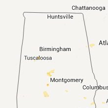
Hail Map for Sunday, July 10, 2011

Number of Impacted Households on 7/10/2011
0
Impacted by 1" or Larger Hail
0
Impacted by 1.75" or Larger Hail
0
Impacted by 2.5" or Larger Hail
Square Miles of Populated Area Impacted on 7/10/2011
0
Impacted by 1" or Larger Hail
0
Impacted by 1.75" or Larger Hail
0
Impacted by 2.5" or Larger Hail


Cities Most Affected by Hail Storms of 7/10/2011
| Hail Size | Demographics of Zip Codes Affected | ||||||
|---|---|---|---|---|---|---|---|
| City | Count | Average | Largest | Pop Density | House Value | Income | Age |
| Glen Ullin, ND | 4 | 2.69 | 5.00 | 1 | $34k | $28.6k | 51.0 |
| Merna, NE | 1 | 2.50 | 2.50 | 3 | $39k | $31.3k | 42.8 |
| Fort Yates, ND | 1 | 2.00 | 2.00 | 1 | $69k | $24.8k | 25.4 |
| Gladstone, ND | 1 | 2.00 | 2.00 | 1 | $51k | $36.5k | 48.9 |
| Broken Bow, NE | 1 | 2.00 | 2.00 | 12 | $57k | $31.8k | 42.8 |
| Eureka, SD | 1 | 1.75 | 1.75 | 1 | $20k | $22.4k | 58.4 |
| Selfridge, ND | 1 | 1.75 | 1.75 | 0 | $35k | $22.4k | 30.7 |
| Arnold, NE | 1 | 1.75 | 1.75 | 2 | $39k | $27.5k | 48.8 |
Hail and Wind Damage Spotted on 7/10/2011
Filter by Report Type:Hail ReportsWind Reports
States Impacted
South Dakota, North Dakota, Alabama, Colorado, Nevada, Georgia, Kansas, Arizona, Minnesota, Nebraska, Mississippi, Utah, Idaho, Wisconsin, Iowa, Illinois, MichiganSouth Dakota
| Local Time | Report Details |
|---|---|
| 2:17 PM UTC | Medium to large branches down. hail of unknown size but no hail damage note in miner county SD, 44.9 miles WNW of Sioux Falls, SD |
| 8:35 PM UTC | Quarter sized hail reported near Pollock, SD, 66.8 miles SSE of Bismarck, ND |
| 8:45 PM UTC | Wind gust at the sand lake raws station. time estimated by rada in mcpherson county SD, 52.6 miles WNW of Aberdeen, SD |
| 8:45 PM UTC | Quarter sized hail reported near Pollock, SD, 66 miles SSE of Bismarck, ND, 60 mph winds also |
| 9:15 PM UTC | Golf Ball sized hail reported near Eureka, SD, 58 miles WNW of Aberdeen, SD, 60 mph winds also...garden is ruined |
| 9:55 PM UTC | Trees down in brown county SD, 33.3 miles NNE of Aberdeen, SD |
| 10:00 PM UTC | Storm damage reported in brown county SD, 3.5 miles N of Aberdeen, SD |
| 10:00 PM UTC | Quarter size hail also reported in brown county SD, 30.2 miles NNE of Aberdeen, SD |
| 10:20 PM UTC | Trees down in the town of britto in marshall county SD, 42.4 miles ENE of Aberdeen, SD |
| 10:30 PM UTC | Top half cut off a 12 ft. tree. 1 inch of rain in 15 mi in brown county SD, 26.7 miles ENE of Aberdeen, SD |
| 10:50 PM UTC | Raws observation in marshall county SD, 54.8 miles ENE of Aberdeen, SD |
| 11:10 PM UTC | At least one boat lift flipped in day county SD, 58.7 miles E of Aberdeen, SD |
| 11:30 PM UTC | Quarter sized hail reported near Webster, SD, 54.1 miles E of Aberdeen, SD, estimated 50 mph winds and very heavy rain also |
| 12:27 AM UTC | Storm damage reported in grant county SD, 48.3 miles WNW of Montevideo, MN |
| 1:00 AM UTC | 6 inch to 8 inch diameter branches down in town of clear lake in deuel county SD, 48.9 miles WSW of Montevideo, MN |
| 5:33 AM UTC | Tree limbs down in yankton county SD, 54.8 miles SSW of Sioux Falls, SD |
| 6:20 AM UTC | Branches down in union county SD, 65.1 miles S of Sioux Falls, SD |
| 6:28 AM UTC | Power out in yankton county SD, 54.8 miles SSW of Sioux Falls, SD |
| 6:35 AM UTC | 4 to 6 inch branches snapped for tree in yankton county SD, 54.8 miles SSW of Sioux Falls, SD |
North Dakota
| Local Time | Report Details |
|---|---|
| 4:15 PM UTC | Hen Egg sized hail reported near Gladstone, ND, 85 miles W of Bismarck, ND, hail estimated at 2 inches based upon photo provided by media. |
| 4:30 PM UTC | Softball sized hail reported near Glen Ullin, ND, 50.8 miles W of Bismarck, ND, mostly pea size hail and heavy rain. no damage to report. |
| 4:30 PM UTC | Hen Egg sized hail reported near Glen Ullin, ND, 47.2 miles W of Bismarck, ND |
| 4:30 PM UTC | Hen Egg sized hail reported near Glen Ullin, ND, 50.8 miles W of Bismarck, ND, mostly pea size hail with a few larger stones. no damage to report. correction to earlier report. |
| 4:50 PM UTC | Golf Ball sized hail reported near Glen Ullin, ND, 47.2 miles W of Bismarck, ND |
| 5:02 PM UTC | Quarter sized hail reported near Almont, ND, 43.3 miles W of Bismarck, ND, nickel to quarter size hail. |
| 5:25 PM UTC | Strong winds lasted 15 minutes. also pea sized hai in morton county ND, 9 miles SW of Bismarck, ND |
| 6:43 PM UTC | Quarter sized hail reported near Mandan, ND, 12 miles SSW of Bismarck, ND, lasted 10 minutes |
| 6:45 PM UTC | 2 foot in diamater oak trees were uprooted near huff. initial estimates of winds in excess of 75 mp in morton county ND, 14.2 miles SSE of Bismarck, ND |
| 6:50 PM UTC | Half Dollar sized hail reported near Bismarck, ND, 3.9 miles SSE of Bismarck, ND, lasted until 205 pm. peak wind speeds around 40 mph. this is falconer estates subdivision. several homes had roof and gutter damage. leaves...small branches...and fruit |
| 6:50 PM UTC | Golf Ball sized hail reported near Selfridge, ND, 51 miles SSW of Bismarck, ND |
| 6:52 PM UTC | Nws employee estimated 75 mph wind gusts and penny sized hai in burleigh county ND, 6.5 miles SE of Bismarck, ND |
| 6:53 PM UTC | Quarter sized hail reported near Bismarck, ND, 6.4 miles SE of Bismarck, ND, nickel to qaurter size hail. |
| 7:14 PM UTC | Double power lines are snapped about 2 miles south of moffit road on 262nd st s in burleigh county ND, 23.5 miles ESE of Bismarck, ND |
| 7:15 PM UTC | Relayed by media. measured with home anemomete in emmons county ND, 32.7 miles SE of Bismarck, ND |
| 7:20 PM UTC | Double poled wood transmission lines snapped in half. heavy ranch sign with three foot concrete anchors ripped out of the ground. camper flipped off of the highway and in emmons county ND, 26.5 miles ESE of Bismarck, ND |
| 7:24 PM UTC | Minor damage to farmstead. shingles blown off of trailer home and small building blown over. winds estimated at 70 mp in emmons county ND, 31.1 miles ESE of Bismarck, ND |
| 7:28 PM UTC | Extensive tree branch damage in hazelton. three inch to six inch in diameter branches blown off of trees. gas station on the west side of town had damage to the roof ov in emmons county ND, 32.7 miles SE of Bismarck, ND |
| 7:33 PM UTC | Also had 1 inch hail and heavy rai in sioux county ND, 49.9 miles S of Bismarck, ND |
| 7:33 PM UTC | Storm damage reported in emmons county ND, 38.6 miles ESE of Bismarck, ND |
| 7:35 PM UTC | Empty grain bins damaged. winds estimated at 85 mp in logan county ND, 52.1 miles ESE of Bismarck, ND |
| 7:40 PM UTC | Hen Egg sized hail reported near Fort Yates, ND, 52.7 miles S of Bismarck, ND, heavy rain. |
| 7:57 PM UTC | Storm damage reported in logan county ND, 62.5 miles ESE of Bismarck, ND |
| 8:40 PM UTC | Arb observer reported 70 to 80 miles per hour winds with grain bin blown down. 2.90 inches precipitation in 40 minutes and 3/4 inch hai in dickey county ND, 56.9 miles NNW of Aberdeen, SD |
| 9:02 PM UTC | Winds estimated at 50 to 60 mph...pea size hai in lamoure county ND, 65 miles NNW of Aberdeen, SD |
| 9:09 PM UTC | Shingles blown off roof. winds estimated at least 60 mp in mcintosh county ND, 46.8 miles NW of Aberdeen, SD |
| 9:30 PM UTC | Grain bins blown ove in lamoure county ND, 64.3 miles NNW of Aberdeen, SD |
| 9:31 PM UTC | Numerous tree branches down. winds estimated up to 80 mp in dickey county ND, 49.9 miles N of Aberdeen, SD |
| 9:35 PM UTC | Roof damage to building and sheet metal missin in dickey county ND, 37.4 miles N of Aberdeen, SD |
| 9:42 PM UTC | Numerous trees and branches down in and around ludde in dickey county ND, 41.8 miles NNE of Aberdeen, SD |
| 10:00 PM UTC | Some houses missing shingles off roof. large trees down in tow in sargent county ND, 60.8 miles NE of Aberdeen, SD |
| 10:06 PM UTC | Law enforcement estimates 60 mph wind gust in sargent county ND, 56.5 miles NE of Aberdeen, SD |
| 10:10 PM UTC | Roof blown off machine shop. time approximat in sargent county ND, 52.5 miles NE of Aberdeen, SD |
| 10:15 PM UTC | Roof on grain bin collapsed in sargent county ND, 54 miles NE of Aberdeen, SD |
| 10:17 PM UTC | Trained spotter estimates 70 mph wind gust that has knocked over large tree branches in sargent county ND, 59.8 miles SW of Fargo, ND |
| 10:30 PM UTC | Barn and four grain bins blown off their foundations. pole barn lost its roof. several trees uprooted and branches up to a foot in diameter snapped. estimated wind gust in sargent county ND, 59.3 miles NE of Aberdeen, SD |
| 10:38 PM UTC | Report of trees down in cayuga in sargent county ND, 61.9 miles SSW of Fargo, ND |
| 10:40 PM UTC | Storm damage reported in richland county ND, 58.4 miles SSW of Fargo, ND |
| 11:20 PM UTC | Grain bin damage in richland county ND, 59.8 miles S of Fargo, ND |
| 11:32 PM UTC | Trees down at farmstead...including tree leaning on house. surrounding shelterbelts do not seem to have as much damag in richland county ND, 48.3 miles SSW of Fargo, ND |
Alabama
| Local Time | Report Details |
|---|---|
| 8:05 PM UTC | One tree down on powerline in northeast dale county. pea size hail also reporte in dale county AL, 70.8 miles S of Auburn, AL |
| 9:25 PM UTC | Tin roof partially removed from outbuilding along cr 88. several trees down along cr 45 and cr 76. winds estimated around 50 mp in dallas county AL, 33.6 miles N of Camden, AL |
| 9:25 PM UTC | Tin roof partially removed from outbuilding along cr 88. winds estimated around 50 mp in dallas county AL, 33.6 miles N of Camden, AL |
Colorado
| Local Time | Report Details |
|---|---|
| 8:21 PM UTC | Storm damage reported in boulder county CO, 15.9 miles NW of Denver, CO |
| 8:30 PM UTC | Storm damage reported in boulder county CO, 16.2 miles NNW of Denver, CO |
| 9:52 PM UTC | Storm damage reported in elbert county CO, 36 miles SE of Denver, CO |
| 1:31 AM UTC | 6 inch live tree branch blow down and several power poles leaned over by wind gus in yuma county CO, 26.3 miles E of Yuma, CO |
Nevada
| Local Time | Report Details |
|---|---|
| 8:28 PM UTC | Storm damage reported in clark county NV, 4.3 miles NW of Las Vegas, NV |
| 8:30 PM UTC | An entire line of power poles was snapped off...at least a block long...and power was out along cheyenne avenue from valley drive to allen drive. time is estimate in clark county NV, 6.8 miles N of Las Vegas, NV |
| 8:30 PM UTC | A 60 foot tall tree was uprooted by thunderstorm wind in clark county NV, 2.2 miles W of Las Vegas, NV |
| 8:30 PM UTC | 2 large signs...a wendys and a walrgrees sign...were blown out and onto the ground at the intersection of rancho and washington. the time is estimate in clark county NV, 2.3 miles WNW of Las Vegas, NV |
| 8:30 PM UTC | Thunderstorm winds blew a tree onto a house on vegas drive near simmons street. the tree landed in the living room of the hous in clark county NV, 2.6 miles WNW of Las Vegas, NV |
| 8:30 PM UTC | Thunderstorm winds blew a tree onto a house on vegas driv in clark county NV, 3.1 miles WNW of Las Vegas, NV |
| 8:30 PM UTC | Large tree snapped at the base in the rancho circle area. the event time was estimate in clark county NV, 1.7 miles W of Las Vegas, NV |
| 8:40 PM UTC | 2 large signs...a wendys and a walrgrees sign...were blown out and onto the ground at the intersection of rancho and washington. the time is estimate in clark county NV, 6.8 miles N of Las Vegas, NV |
| 8:40 PM UTC | An entire line of power poles was snapped off...at least a block long...and power was out. time is estimate in clark county NV, 6.8 miles N of Las Vegas, NV |
| 8:42 PM UTC | *** 1 inj *** las vegas fire public information officer and media reported that the 80 percent of the roof was blown off two buildings at an apartment complex and the m in clark county NV, 2.6 miles WNW of Las Vegas, NV |
| 8:42 PM UTC | *** 1 inj *** las vegas fire public information officer relayed a report of wires down in the area of the north las vegas airport. in addition...roofing materials were in clark county NV, 2.6 miles WNW of Las Vegas, NV |
| 8:45 PM UTC | *** 1 inj *** las vegas fire public information officer relayed a report of wires down in the area of the north las vegas airport. in addition...roofing materials were in clark county NV, 3.9 miles WNW of Las Vegas, NV |
| 11:40 PM UTC | The park service reported that 20 vehicles parked at the las vegas boat harbor had hail of an unknown size and debris such as rocks and mud hit them and break out their in clark county NV, 22.4 miles ESE of Las Vegas, NV |
Georgia
| Local Time | Report Details |
|---|---|
| 8:30 PM UTC | The emergency manager reported several trees were blown down in the northwest section of the county. the time of the event was based on radar imager in camden county GA, 52.7 miles N of Jacksonville, FL |
| 10:08 PM UTC | One tree down blocking west jones ave. time estimated by rada in bulloch county GA, 47.8 miles WNW of Savannah, GA |
Kansas
| Local Time | Report Details |
|---|---|
| 10:45 PM UTC | Four 4-inch limbs were down. the wind was estimated at least 70 mp in rush county KS, 27.8 miles SSW of Hays, KS |
| 11:10 PM UTC | The caller also reported dime-sized hail and 0.55 of rai in rush county KS, 24.2 miles S of Hays, KS |
| 11:20 PM UTC | Large trees were shaking violentl in kearny county KS, 23.8 miles WNW of Garden City, KS |
| 11:25 PM UTC | The caller reported several gusts measured at 6 in pawnee county KS, 48.8 miles SSE of Hays, KS |
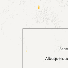
| 12:25 AM UTC | Ping Pong Ball sized hail reported near Oberlin, KS, 35 miles NE of Colby, KS |
| 1:00 AM UTC | Also had dime-sized hai in decatur county KS, 44.2 miles NNE of Colby, KS |
Arizona
| Local Time | Report Details |
|---|---|
| 11:00 PM UTC | Numerous large trees down. roof blown off a hous in la paz county AZ, 43 miles SSE of Lake Havasu City, AZ |
| 11:33 PM UTC | Phoenix sky harbor airport asos measured a 66 mph wind gust in maricopa county AZ, 6.3 miles N of Phoenix, AZ |
| 12:50 AM UTC | Thunderstorm winds downed a power line in lake mead city near smith road and rainbow roa in mohave county AZ, 62.7 miles ESE of Las Vegas, NV |
| 2:30 AM UTC | 17 power poles blown down or snapped along state route 95 between milepost markers 112 and 11 in la paz county AZ, 54.5 miles S of Lake Havasu City, AZ |
Minnesota
| Local Time | Report Details |
|---|---|
| 11:35 PM UTC | Delayed report from july 10th. from the rwis weather station near gracevill in big stone county MN, 55.4 miles NW of Montevideo, MN |
| 11:45 PM UTC | Storm damage reported in traverse county MN, 62.1 miles NNW of Montevideo, MN |
| 11:48 PM UTC | Grain bins blown over in traverse county MN, 64.4 miles SSE of Fargo, ND |
| 12:25 AM UTC | 4 inch diameter branches down in tow in stevens county MN, 45.1 miles NNW of Montevideo, MN |
| 12:30 AM UTC | Large trees downe in douglas county MN, 62.3 miles N of Montevideo, MN |
| 12:40 AM UTC | Over a dozen large trees downed within town. estimated wind speeds 60 to 80 mp in douglas county MN, 60.5 miles NNE of Montevideo, MN |
| 12:47 AM UTC | Mndot i-94 and mn hwy 29 mile post 46 in douglas county MN, 65.5 miles NNE of Montevideo, MN |
| 12:50 AM UTC | Scattered large up to 30 diameter tree in pope county MN, 46.3 miles N of Montevideo, MN |
| 12:52 AM UTC | Large trees and powerlines down in douglas county MN, 70.6 miles N of Montevideo, MN |
| 12:53 AM UTC | Axn airport in douglas county MN, 65.5 miles NNE of Montevideo, MN |
| 12:58 AM UTC | Mehurin us-hwy 212 mile post 1 in lac qui parle county MN, 34.5 miles W of Montevideo, MN |
| 12:59 AM UTC | Measured at glenwood municipal airpor in pope county MN, 51 miles NNE of Montevideo, MN |
| 12:59 AM UTC | Eight inch diameter tree dow in pope county MN, 51 miles NNE of Montevideo, MN |
| 1:10 AM UTC | Approximately two hundred trees in sauk centre were either uprooted or snapped with this line of storms. tree damage was noted from interstate 94 in the south to the sa in stearns county MN, 65.8 miles NE of Montevideo, MN |
| 1:10 AM UTC | Estimated time...enhanced unidirectional damage large grain equipment trailers flippe in stearns county MN, 65.8 miles NE of Montevideo, MN |
| 1:10 AM UTC | Estimated time numerous trees down from 5 miles west right through to sauk centr in stearns county MN, 65.8 miles NE of Montevideo, MN |
| 1:10 AM UTC | Estimated time power lines down and power out in tow in stearns county MN, 65.8 miles NE of Montevideo, MN |
| 1:14 AM UTC | Airport awos in lac qui parle county MN, 23.5 miles W of Montevideo, MN |
| 1:15 AM UTC | Quarter sized hail reported near Dawson, MN, 15.3 miles W of Montevideo, MN |
| 1:25 AM UTC | Storm damage reported in lincoln county MN, 41 miles SW of Montevideo, MN |
| 1:45 AM UTC | Mndot hwy 23 and mile post 94 in yellow medicine county MN, 18.7 miles SSE of Montevideo, MN |
| 1:45 AM UTC | Entire row of full grown 16 inch diameter trees down along with with 2 to 8 inch branche in stearns county MN, 70.7 miles NE of Montevideo, MN |
| 1:45 AM UTC | Power lines dow in stearns county MN, 70.7 miles NE of Montevideo, MN |
| 1:55 AM UTC | Trees down large branches in stearns county MN, 75.1 miles NW of Minneapolis, MN |
| 1:59 AM UTC | Eight inch diameter tree dow in pope county MN, 51 miles NNE of Montevideo, MN |
| 2:00 AM UTC | Est 70 mph winds...one foot diameter trees dow in aitkin county MN, 78.6 miles WSW of Duluth, MN |
| 2:04 AM UTC | A few large trees dow in meeker county MN, 60.4 miles WNW of Minneapolis, MN |
| 2:15 AM UTC | Power out in renville county MN, 27.3 miles ESE of Montevideo, MN |
| 2:22 AM UTC | Stc airport asos in stearns county MN, 59.2 miles NW of Minneapolis, MN |
| 2:24 AM UTC | Ovl airport awos estimated tim in renville county MN, 37.2 miles ESE of Montevideo, MN |
| 2:30 AM UTC | Damage over a 3/4 mile path in renville county MN, 51.3 miles SE of Montevideo, MN |
| 2:50 AM UTC | 30 foot pine tree snapped off sunday evening in anoka county MN, 20.6 miles NNW of Minneapolis, MN |
| 3:00 AM UTC | Large tree dow in hennepin county MN, 17.7 miles NW of Minneapolis, MN |
| 3:04 AM UTC | Numerous large branches downed along with several road signs blown dow in sibley county MN, 60.6 miles ESE of Montevideo, MN |
| 3:05 AM UTC | Storm damage reported in mcleod county MN, 60.8 miles WSW of Minneapolis, MN |
| 3:15 AM UTC | Moderate to severe damage of corn crop in pipestone county MN, 47 miles NE of Sioux Falls, SD |
| 3:15 AM UTC | Quarter sized hail reported near Woodstock, MN, 47 miles NE of Sioux Falls, SD |
| 3:30 AM UTC | Two inch diameter tree branches dow in watonwan county MN, 86 miles SE of Montevideo, MN |
| 3:42 AM UTC | Numerous powerlines down throughout the county. a large tree downed 1sw henderso in sibley county MN, 45.2 miles SW of Minneapolis, MN |
| 3:45 AM UTC | Ten inch diameter tree dow in anoka county MN, 17.1 miles NNW of Minneapolis, MN |
| 3:45 AM UTC | One foot diameter tree branch felle in hennepin county MN, 7.7 miles SW of Minneapolis, MN |
| 3:45 AM UTC | 10 inch tree dow in anoka county MN, 21.4 miles NNW of Minneapolis, MN |
| 3:50 AM UTC | Power out 38th to 44th central av in anoka county MN, 5 miles N of Minneapolis, MN |
| 3:54 AM UTC | Power out in place in washington county MN, 24.8 miles NNE of Minneapolis, MN |
| 4:00 AM UTC | Two inch diameter trees dow in washington county MN, 24.8 miles NNE of Minneapolis, MN |
| 4:00 AM UTC | Nine inch diameter trees down. powerlines down. occurred on 2nd stree in le sueur county MN, 47.9 miles SW of Minneapolis, MN |
| 4:00 AM UTC | Trees and power lines down. some building damag in le sueur county MN, 47.9 miles SW of Minneapolis, MN |
| 4:08 AM UTC | Several twelve inch diameter trees downed. occurred in different parts of tow in le sueur county MN, 47.9 miles SW of Minneapolis, MN |
| 4:20 AM UTC | Storm damage reported in waseca county MN, 63.2 miles S of Minneapolis, MN |
| 4:58 AM UTC | Wind gusts measured 80 to 100 mp in dodge county MN, 60 miles SSE of Minneapolis, MN |
| 5:00 AM UTC | Powerline down in goodhue county MN, 42.8 miles SE of Minneapolis, MN |
| 5:09 AM UTC | Measured with anemomete in goodhue county MN, 61.8 miles SSE of Minneapolis, MN |
| 5:22 AM UTC | Power outages in area in wabasha county MN, 60.6 miles SE of Minneapolis, MN |
| 5:40 AM UTC | Trees down along highway 61 north of town in wabasha county MN, 52.7 miles NW of La Crosse, WI |
| 8:15 AM UTC | Trees down in jackson county MN, 61.7 miles N of Storm Lake, IA |
Nebraska
| Local Time | Report Details |
|---|---|
| 12:26 AM UTC | Quarter sized hail reported near Tryon, NE, 39.3 miles NNW of North Platte, NE |
| 12:52 AM UTC | 6 inch diameter tree branches were snapped off his elm tre in logan county NE, 28.8 miles NE of North Platte, NE |
| 1:15 AM UTC | Storm damage reported in custer county NE, 36 miles NE of North Platte, NE |
| 1:15 AM UTC | Golf Ball sized hail reported near Arnold, NE, 36 miles NE of North Platte, NE, also estimated 60 mile per hour wind gusts with small branch damage. |
| 1:20 AM UTC | 7 to 8 inch diameter green tree limbs broken of in red willow county NE, 59.8 miles NNE of Colby, KS |
| 1:28 AM UTC | Local law enforcement reported 2 to 3 large cottonwood trees were blown down in and just west of edison. a 20 to 30 foot long tree limb that is 8 to 10 inches in diamet in furnas county NE, 78.5 miles SE of North Platte, NE |
| 1:28 AM UTC | Ping Pong Ball sized hail reported near Arnold, NE, 43.9 miles NE of North Platte, NE |
| 1:39 AM UTC | Storm damage reported in dundy county NE, 52.2 miles NNW of Colby, KS |
| 1:45 AM UTC | Storm damage reported in dundy county NE, 52.2 miles NNW of Colby, KS |
| 1:45 AM UTC | A few shingles blown off roof of hous in hitchcock county NE, 58.2 miles N of Colby, KS |
| 1:48 AM UTC | Storm damage reported in furnas county NE, 78.1 miles SE of North Platte, NE |
| 1:50 AM UTC | Ping Pong Ball sized hail reported near Merna, NE, 51.1 miles ENE of North Platte, NE |
| 1:57 AM UTC | Storm damage reported in frontier county NE, 59.4 miles SSE of North Platte, NE |
| 2:05 AM UTC | Delayed report from evening of july 10th. southwest public power substation at hayes center recorded a wind gust to 71 mph on automated davis weather statio in hayes county NE, 45.3 miles SSW of North Platte, NE |
| 2:05 AM UTC | Quarter sized hail reported near Oxford, NE, 83.5 miles SW of Grand Island, NE |
| 2:05 AM UTC | Hen Egg sized hail reported near Broken Bow, NE, 61.2 miles ENE of North Platte, NE |
| 2:05 AM UTC | Tennis Ball sized hail reported near Merna, NE, 56 miles ENE of North Platte, NE, said there was tree damage with spiked hailstones the size of tennis balls. |
| 2:16 AM UTC | Storm damage reported in hayes county NE, 51.4 miles SSW of North Platte, NE |
| 9:16 PM CDT | Half Dollar sized hail reported near Broken Bow, NE, 61.4 miles ENE of North Platte, NE |
| 2:26 AM UTC | Power lines down in holdreg in phelps county NE, 64.1 miles WSW of Grand Island, NE |
| 2:28 AM UTC | Storm damage reported in dawson county NE, 42.4 miles SE of North Platte, NE |
| 2:29 AM UTC | 60 mile per hour winds northwest of holdrege and nickel size hai in phelps county NE, 64.3 miles WSW of Grand Island, NE |
| 2:30 AM UTC | Storm damage reported in lincoln county NE, 28.7 miles SSE of North Platte, NE |
| 2:30 AM UTC | Ping Pong Ball sized hail reported near Holdrege, NE, 62.9 miles SW of Grand Island, NE |
| 2:33 AM UTC | Quarter sized hail reported near Maxwell, NE, 28.7 miles SSE of North Platte, NE |
| 2:37 AM UTC | Storm damage reported in hayes county NE, 52 miles SSW of North Platte, NE |
| 2:37 AM UTC | Trailer house was blown over on the west edge of holdrege. mulitple power outages across holdredge and tree limbs with a diameter up to 2 to 6 inches blown dow in furnas county NE, 69.9 miles SE of North Platte, NE |
| 2:37 AM UTC | Trailer house was blown over on the west edge of holdrege. mulitple power outages across holdredge and tree limbs with a diameter up to 2 to 6 inches blown dow in phelps county NE, 64.1 miles WSW of Grand Island, NE |
| 2:42 AM UTC | 60 mile per hour wind in axtell with dime size hai in kearney county NE, 51.6 miles SW of Grand Island, NE |
| 2:42 AM UTC | Storm damage reported in lincoln county NE, 32.5 miles SE of North Platte, NE |
| 2:45 AM UTC | Quarter sized hail reported near Lexington, NE, 58.9 miles ESE of North Platte, NE |
| 2:48 AM UTC | Storm damage reported in buffalo county NE, 41.8 miles WSW of Grand Island, NE |
| 2:55 AM UTC | Storm damage reported in buffalo county NE, 41.8 miles WSW of Grand Island, NE |
| 3:10 AM UTC | Farmer reported some green snap damage to his corn crop and basketball hoop blown over as thunderstorms passed over his location. report delayed from evening of july 10 in custer county NE, 45.2 miles ENE of North Platte, NE |
| 3:10 AM UTC | Farmer reported some green snap damage to his corn crop and basketball hoop blown over as thunderstorms passed over his location. report delayed from evening of july 10 in custer county NE, 31.5 miles E of North Platte, NE |
| 3:20 AM UTC | Storm damage reported in hall county NE, 5.2 miles W of Grand Island, NE |
| 3:30 AM UTC | A utility pole was knocked down near 8th and 3rd streets and a large tree was blown over at 31st and e street. power was knocked out in ravenn in buffalo county NE, 41.8 miles WSW of Grand Island, NE |
| 3:39 AM UTC | 60 mile per hour winds for the past 10 minute on the corner of wildwood and highway 28 in hall county NE, 1.6 miles WSW of Grand Island, NE |
| 3:43 AM UTC | Storm damage reported in hall county NE, 3.3 miles NNE of Grand Island, NE |
| 3:43 AM UTC | Estimated 65 mile per hour winds with penny size hail. some tree branches and power lines down as wel in hall county NE, 1.6 miles WSW of Grand Island, NE |
| 3:50 AM UTC | Roof blown off of a shed and knocked a wall down as wel in greeley county NE, 42.1 miles NNW of Grand Island, NE |
| 4:00 AM UTC | Storm damage reported in valley county NE, 45 miles NNW of Grand Island, NE |
| 4:02 AM UTC | Quarter sized hail reported near , , 18.2 miles ESE of Grand Island, NE, quarter size hail lasted 2 minutes with 40 mile per hour winds. |
| 4:03 AM UTC | Numerous reports of trees down in palmer in merrick county NE, 22 miles NNE of Grand Island, NE |
| 4:16 AM UTC | Elba is without powe in howard county NE, 27.3 miles NNW of Grand Island, NE |
| 4:20 AM UTC | Estimated 50 to 60 mile per hour winds just south of fullerton in nance county NE, 35.7 miles NNE of Grand Island, NE |
| 4:22 AM UTC | Difficult to keep car on the road in boone county NE, 54.4 miles NNE of Grand Island, NE |
| 4:36 AM UTC | Numerous trees down...some vehicle damage...damage reports were from 1136 to 1146 p in platte county NE, 61.9 miles NE of Grand Island, NE |
| 4:56 AM UTC | Storm damage reported in madison county NE, 69.6 miles ESE of Oneill, NE |
| 5:01 AM UTC | Storm damage reported in butler county NE, 63 miles W of Omaha, NE |
| 5:05 AM UTC | Sustained for 1.5 minutes. widespread power outages throughout the county. estimated 3000 to 4000 people without powe in stanton county NE, 78 miles ESE of Oneill, NE |
| 5:05 AM UTC | Numerous tree limbs downed...some eight inches in diameter...power ou in pierce county NE, 54.1 miles E of Oneill, NE |
| 5:13 AM UTC | Storm damage reported in madison county NE, 69.6 miles ESE of Oneill, NE |
| 5:13 AM UTC | Quarter sized hail reported near David City, NE, 61.9 miles W of Omaha, NE |
| 5:15 AM UTC | Storm damage reported in holt county NE, 2.1 miles W of Oneill, NE |
| 5:20 AM UTC | Law enforcement reported wind caused structual and tree damage on the west side of oneill to include downed trees 8 inches in diameter and blown out window in holt county NE, 0.2 miles NNW of Oneill, NE |
| 5:24 AM UTC | Storm damage reported in wayne county NE, 84.7 miles E of Oneill, NE |
| 5:32 AM UTC | Storm damage reported in thurston county NE, 70.6 miles NW of Omaha, NE |
| 5:55 AM UTC | Power outages in newcastle in dixon county NE, 62.2 miles S of Sioux Falls, SD |
| 6:09 AM UTC | Measured thunderstorm gust by home wind equipment on roof. scattered tree damage with some power outages...mainly on north side of tow in douglas county NE, 3.6 miles W of Omaha, NE |
Mississippi
| Local Time | Report Details |
|---|---|
| 12:30 AM UTC | Power lines down along flowood drive just east of airport roa in rankin county MS, 4.4 miles ENE of Jackson, MS |
Utah
| Local Time | Report Details |
|---|---|
| 1:20 AM UTC | Sr-30 sensor in box elder county UT, 72.1 miles N of Salt Lake City, UT |
Idaho
| Local Time | Report Details |
|---|---|
| 2:20 AM UTC | Several small branches were blown out of trees. no size give in bear lake county ID, 91.6 miles NNE of Salt Lake City, UT |
Wisconsin
| Local Time | Report Details |
|---|---|
| 5:23 AM UTC | Measured with anemomete in dunn county WI, 64.8 miles ESE of Minneapolis, MN |
| 5:28 AM UTC | Eight inch diameter tree toppled onto powerline in dunn county WI, 66.5 miles E of Minneapolis, MN |
| 5:30 AM UTC | Three inch diameter tree fell over roa in dunn county WI, 65.7 miles E of Minneapolis, MN |
| 5:31 AM UTC | Pick-up truck with trailer hauling several canoes rolled over. occurred on highway 17 in dunn county WI, 63.1 miles E of Minneapolis, MN |
| 6:00 AM UTC | Eight inch diameter tree toppled over road. occurred on 770th ave...bewteen hwy 40 and 808th s in dunn county WI, 66.7 miles E of Minneapolis, MN |
| 7:24 AM UTC | 18 inch diameter trees blown dow in monroe county WI, 21.6 miles ENE of La Crosse, WI |
| 7:40 AM UTC | Tree blown down in monroe county WI, 39.5 miles ENE of La Crosse, WI |
| 8:04 AM UTC | Some trees down in wisconsin rapids...power outages in marshfield in wood county WI, 81.1 miles ENE of La Crosse, WI |
| 8:05 AM UTC | Trees down in germantown township and around necedah in juneau county WI, 61.7 miles E of La Crosse, WI |
| 8:06 AM UTC | Trees down in portage county WI, 83 miles W of Green Bay, WI |
| 8:25 AM UTC | Trees down in jackson township in adams county WI, 49 miles NNW of Madison, WI |
| 8:40 AM UTC | Tree down on johnson road in waupaca county WI, 58.7 miles WSW of Green Bay, WI |
| 9:05 AM UTC | Storm damage reported in green lake county WI, 59.8 miles SW of Green Bay, WI |
| 10:57 AM UTC | There was some corn flattened along county road in grant county WI, 69.6 miles WSW of Madison, WI |
| 10:59 AM UTC | Grain dryer and other farm equipment damaged. also corn flattened along county road h in same general locatio in grant county WI, 69.2 miles WSW of Madison, WI |
| 11:00 AM UTC | Trees and powerlines down around kiele in grant county WI, 69 miles NE of Cedar Rapids, IA |
| 11:05 AM UTC | Car wash building has roof torn off and a brick wall on its side knocked dow in grant county WI, 68.3 miles WSW of Madison, WI |
| 11:25 AM UTC | Reports of trees and powerlines down in various locations in lafayette count in lafayette county WI, 46.1 miles SW of Madison, WI |
| 11:56 AM UTC | Dialed voice. sustained 40 knots gust to 54 knots. still 38 knots gusting to 51 knots at 706 a in green county WI, 32.9 miles SSW of Madison, WI |
| 11:58 AM UTC | Storm damage reported in green county WI, 33.3 miles S of Madison, WI |
Iowa
| Local Time | Report Details |
|---|---|
| 6:35 AM UTC | Branches and trees dow in plymouth county IA, 50.3 miles WNW of Storm Lake, IA |
| 6:55 AM UTC | Storm damage reported in cherokee county IA, 19.1 miles WNW of Storm Lake, IA |
| 7:00 AM UTC | Damage to a garage and branches down in o'brien county IA, 26.9 miles NW of Storm Lake, IA |
| 7:10 AM UTC | Tree down partially blocking highway in cass county IA, 49.3 miles ENE of Omaha, NE |
| 7:30 AM UTC | Several large tree branches in area down. heavy patio table with umbrella toppled and blown many feet. damage to lawn furniture...garbage containers...yard decor...all in cass county IA, 49.3 miles ENE of Omaha, NE |
| 7:46 AM UTC | 2 to 4 inch diameter limbs down in yal in guthrie county IA, 40.7 miles WNW of Des Moines, IA |
| 8:05 AM UTC | Storm damage reported in webster county IA, 53.9 miles ESE of Storm Lake, IA |
| 8:20 AM UTC | Delayed report. time estimated. 10 x 34 ft section of a newly constructed house roof blown off and trusses snapped in half. several 18 to 24 ft diameter trees snapped o in polk county IA, 18.6 miles NNW of Des Moines, IA |
| 8:20 AM UTC | Corrugated steel roof from a house ripped off and thrown approximately 120 yards. a section of the roof impaled the side of a neighboring house...with part of the metal in polk county IA, 18.9 miles NNW of Des Moines, IA |
| 8:22 AM UTC | 4 inch limbs down...heavy rain...wind increasing in polk county IA, 6 miles NW of Des Moines, IA |
| 8:25 AM UTC | Spotter estimated 60 mph gus in polk county IA, 10.4 miles N of Des Moines, IA |
| 8:25 AM UTC | Trees down and crop damage in story county IA, 19.2 miles NNW of Des Moines, IA |
| 8:25 AM UTC | Several large tree branches down along merle hay road. largest was four to five inches in diameter. time estimated from rada in polk county IA, 8.8 miles NNW of Des Moines, IA |
| 8:25 AM UTC | Trees down in story county IA, 21 miles N of Des Moines, IA |
| 8:25 AM UTC | Trees down in polk county IA, 15.5 miles NNW of Des Moines, IA |
| 8:30 AM UTC | Who tv radar blown into a farm field and destroye in polk county IA, 15.9 miles N of Des Moines, IA |
| 8:30 AM UTC | Numerous 10 to 12 inch in diameter trees snapped...largest trees downed were 3 ft in diameter. trees laying in different directions. power lines down across the area. a in polk county IA, 17.8 miles NNW of Des Moines, IA |
| 8:30 AM UTC | Numerous 10 to 12 inch in diameter trees snapped. power lines down across the area. amateur radio repeater tower dow in polk county IA, 17.8 miles NNW of Des Moines, IA |
| 8:31 AM UTC | Storm damage reported in polk county IA, 11.1 miles N of Des Moines, IA |
| 8:31 AM UTC | Some shingles ripped off the roof of a hous in polk county IA, 11.1 miles N of Des Moines, IA |
| 8:35 AM UTC | Power lines down along hwy 69 near the polk county line. time estimated from rada in story county IA, 20 miles N of Des Moines, IA |
| 8:43 AM UTC | 59 mph wind gust measured at amw aso in story county IA, 29.7 miles N of Des Moines, IA |
| 8:45 AM UTC | Roof ripped off of a mobile home. time estimated from rada in story county IA, 23.5 miles NNE of Des Moines, IA |
| 8:50 AM UTC | Shed destroyed. time estimated from rada in story county IA, 26.6 miles NE of Des Moines, IA |
| 8:57 AM UTC | Storm damage reported in jasper county IA, 29.2 miles NE of Des Moines, IA |
| 9:00 AM UTC | Delayed report. time estimated from radar. roof blown off buildin in marion county IA, 37.7 miles ESE of Des Moines, IA |
| 9:04 AM UTC | Power poles snapped in half near highway 30...330 junctio in marshall county IA, 46.7 miles NE of Des Moines, IA |
| 9:05 AM UTC | 1 to 2 miles of topped trees along the haverhill blacktop just south of marshalltow in marshall county IA, 47.9 miles NE of Des Moines, IA |
| 9:09 AM UTC | Extensive damage reported in marshalltown...trees over roads...trees on homes...gas leaks...possible structural damag in marshall county IA, 47.9 miles NE of Des Moines, IA |
| 9:12 AM UTC | Trees down...transformers down...power outages...high winds reported...no estimate of spee in poweshiek county IA, 47.5 miles ENE of Des Moines, IA |
| 9:13 AM UTC | Semi blown over on highway 30...near le grand in marshall county IA, 51.6 miles NE of Des Moines, IA |
| 9:20 AM UTC | Measured on personal weather station. damage noted includes fences down...trees snapped...and siding ripped from house in marshall county IA, 45.5 miles NE of Des Moines, IA |
| 9:22 AM UTC | 70 to 100 mph winds estimated between montour and toledo. road signs blown down...power outage in tama county IA, 52.8 miles W of Cedar Rapids, IA |
| 9:23 AM UTC | Numerous large trees down with a couple on the house. outbuilding damage at the residence as well. a funnel cloud was reported near time damage occurre in marshall county IA, 49 miles NE of Des Moines, IA |
| 9:25 AM UTC | Trees and powerlines down all over the place. time estimated from radar. reported by kww in tama county IA, 46.7 miles W of Cedar Rapids, IA |
| 9:25 AM UTC | Barn and brick silo flattened. many trees down...some up to 3 ft in diameter. time estimated from rada in tama county IA, 46.8 miles W of Cedar Rapids, IA |
| 9:25 AM UTC | A 180 ft radio tower snapped and many trees dow in tama county IA, 48.8 miles W of Cedar Rapids, IA |
| 9:30 AM UTC | Many power lines and trees down in the area including one tree 3.5 feet in diameter. grain bin flattened and at least part of a roof in the yard. windows blown out and in tama county IA, 52.4 miles W of Cedar Rapids, IA |
| 9:30 AM UTC | Many trees and fences down. bins down at the coop and roof torn off of the legion hall. possible natural gas leak note in tama county IA, 52.4 miles W of Cedar Rapids, IA |
| 9:35 AM UTC | Numerous trees down throughout town. grain elevators destroyed...roofs damaged by falling trees...and spotters chimney destroyed by the wind. time estimated from rada in tama county IA, 38 miles W of Cedar Rapids, IA |
| 9:35 AM UTC | Significant damage to the clutier fire department building. significant damage thoughout the county with more details to follow as they come in. time estimated from rad in tama county IA, 38 miles W of Cedar Rapids, IA |
| 9:35 AM UTC | Numerous trees down. no electricity in neighborhood. time estimated from radar. report relayed by kwwl t in tama county IA, 55.3 miles WNW of Cedar Rapids, IA |
| 9:40 AM UTC | Numerous trees down...windows broke out and rescue crews called out. time estimated from radar. report relayed by kwwl t in tama county IA, 35.3 miles WNW of Cedar Rapids, IA |
| 9:41 AM UTC | Trees limbs down and power out. swing set wrapped around a tre in tama county IA, 35.3 miles WNW of Cedar Rapids, IA |
| 9:49 AM UTC | Storm damage reported in benton county IA, 24.5 miles W of Cedar Rapids, IA |
| 9:50 AM UTC | Storm damage reported in benton county IA, 31.2 miles W of Cedar Rapids, IA |
| 9:50 AM UTC | Large trees down in town with power outages reported on north sid in benton county IA, 31.2 miles W of Cedar Rapids, IA |
| 9:58 AM UTC | Reported by benton eo in benton county IA, 22.3 miles NW of Cedar Rapids, IA |
| 10:00 AM UTC | 70+ mph winds being seen at this tim in benton county IA, 22.3 miles NW of Cedar Rapids, IA |
| 10:01 AM UTC | Semi blown off highway 150 just north of tow in benton county IA, 23.5 miles NW of Cedar Rapids, IA |
| 10:03 AM UTC | Numerous 12 to 14 inch trees down in town...crop damage is also being seen. time estimated from rada in benton county IA, 27.1 miles W of Cedar Rapids, IA |
| 10:05 AM UTC | Storm damage reported in linn county IA, 1.9 miles SSE of Cedar Rapids, IA |
| 10:05 AM UTC | 2x4 flew through exterior wall of home...knocking tv over inside home...time estimated from rada in benton county IA, 22.3 miles NW of Cedar Rapids, IA |
| 10:09 AM UTC | Estimated 55 to 60 mp in linn county IA, 6.1 miles NNE of Cedar Rapids, IA |
| 10:11 AM UTC | Storm damage reported in linn county IA, 1.9 miles SSE of Cedar Rapids, IA |
| 10:12 AM UTC | Since 5 am have had sustained 60 mph winds...reported by county eo in benton county IA, 22.3 miles NW of Cedar Rapids, IA |
| 10:12 AM UTC | Time estimated from radar...relayed by emergency manage in linn county IA, 8.7 miles NW of Cedar Rapids, IA |
| 10:12 AM UTC | Storm damage reported in linn county IA, 3.3 miles E of Cedar Rapids, IA |
| 10:14 AM UTC | Interstate signs blown over near sunset st exit on i-380...many 4 inch diameter trees snapped off...time estimated from rada in benton county IA, 19.9 miles NNW of Cedar Rapids, IA |
| 10:15 AM UTC | Time estimated from rada in benton county IA, 13.6 miles NW of Cedar Rapids, IA |
| 10:16 AM UTC | 8 small utility size trailers blown over on i-380...lots of flattened crop damage in the area seen as well...time estimated from rada in benton county IA, 19.9 miles NNW of Cedar Rapids, IA |
| 10:20 AM UTC | Lazy acres campground...camper flipped over...time estimated from rada in linn county IA, 15.7 miles NNW of Cedar Rapids, IA |
| 10:21 AM UTC | Metal building completely destroyed with numerous roofs blown over in tow in benton county IA, 12.8 miles NW of Cedar Rapids, IA |
| 10:23 AM UTC | Time estimated from rada in linn county IA, 8.9 miles NNW of Cedar Rapids, IA |
| 10:24 AM UTC | 60+ mph winds...relayed by emergency manage in linn county IA, 15.7 miles NNW of Cedar Rapids, IA |
| 10:24 AM UTC | Time estimated from radar...relayed by emergency manage in linn county IA, 8.7 miles NW of Cedar Rapids, IA |
| 10:24 AM UTC | Semi overturned at center point i-380 truck sto in linn county IA, 15.7 miles NNW of Cedar Rapids, IA |
| 10:25 AM UTC | Numerous power outages reported in town as well as in alburnet in linn county IA, 8.9 miles NNW of Cedar Rapids, IA |
| 10:27 AM UTC | Trees blown down in clayton county IA, 63.4 miles NNE of Cedar Rapids, IA |
| 10:28 AM UTC | County ema reports trees down countywide. occurred between about 520 am and 610 a in jones county IA, 22.3 miles ENE of Cedar Rapids, IA |
| 10:30 AM UTC | 3 foot diameter tree blown down. delayed report relayed by des moines nws offic in linn county IA, 8.7 miles NW of Cedar Rapids, IA |
| 10:30 AM UTC | Numerous trees blown over with some cars damage in linn county IA, 22.3 miles NNW of Cedar Rapids, IA |
| 10:35 AM UTC | Storm damage reported in jones county IA, 31.3 miles NE of Cedar Rapids, IA |
| 10:37 AM UTC | Windows broken in some homes...with some power outages being reported as wel in delaware county IA, 37.1 miles NNE of Cedar Rapids, IA |
| 10:50 AM UTC | Asbury area. 24 inch diameter tree split in half. also 1.3 inches of rain with stor in dubuque county IA, 60 miles NE of Cedar Rapids, IA |
| 10:54 AM UTC | Storm damage reported in jones county IA, 29.7 miles ENE of Cedar Rapids, IA |
| 10:54 AM UTC | Top half of a 12 inch diameter pine tree snapped of in jones county IA, 29.7 miles ENE of Cedar Rapids, IA |
| 10:55 AM UTC | Storm damage reported in dubuque county IA, 57 miles ENE of Cedar Rapids, IA |
| 11:00 AM UTC | Storm damage reported in clinton county IA, 62 miles E of Cedar Rapids, IA |
| 11:00 AM UTC | Two large trees blown dow in clinton county IA, 62 miles E of Cedar Rapids, IA |
| 11:02 AM UTC | 12 inch diameter trees down on property on top of an outbuildin in dubuque county IA, 60 miles NE of Cedar Rapids, IA |
| 11:07 AM UTC | Storm damage reported in dubuque county IA, 57 miles ENE of Cedar Rapids, IA |
| 11:10 AM UTC | Also widespread crop damag in dubuque county IA, 59.6 miles NE of Cedar Rapids, IA |
| 11:10 AM UTC | Storm damage reported in dubuque county IA, 57 miles ENE of Cedar Rapids, IA |
| 11:15 AM UTC | Damage to shingles on hom in scott county IA, 59.4 miles ESE of Cedar Rapids, IA |
| 11:15 AM UTC | Large number of 12 to 16 inch trees down in town...delayed repor in linn county IA, 15.7 miles NNW of Cedar Rapids, IA |
| 11:15 AM UTC | 3 trees blown over lewis access road blocking road to bridge across cedar rive in linn county IA, 13.8 miles NNW of Cedar Rapids, IA |
| 11:25 AM UTC | Power lines down in town. time estimate in clinton county IA, 75 miles E of Cedar Rapids, IA |
| 11:30 AM UTC | 1 inch diameter limbs down in andre in jackson county IA, 57 miles ENE of Cedar Rapids, IA |
| 11:30 AM UTC | Tree branches down blocking streets in maquoketa. time estimated. power outag in jackson county IA, 52.1 miles E of Cedar Rapids, IA |
Illinois
| Local Time | Report Details |
|---|---|
| 11:20 AM UTC | Several large trees blown down along with metal flag pol in jo daviess county IL, 53.7 miles SW of Madison, WI |
| 11:25 AM UTC | Storm damage reported in carroll county IL, 71.4 miles SSW of Madison, WI |
| 11:27 AM UTC | Storm damage reported in jo daviess county IL, 66.4 miles SSW of Madison, WI |
| 11:27 AM UTC | Storm windows blown in. metal yard furniture blown around yard. relayed public report by wre in jo daviess county IL, 59.1 miles SSW of Madison, WI |
| 11:30 AM UTC | Delayed report. e60 mph. numerous 12 inch diameter trees down. trees were snapped off clean approximately 30 feet hig in mchenry county IL, 59.6 miles SE of Madison, WI |
| 11:35 AM UTC | Storm damage reported in jo daviess county IL, 50.5 miles SSW of Madison, WI |
| 11:35 AM UTC | Large tree blown dow in jo daviess county IL, 50.5 miles SSW of Madison, WI |
| 11:45 AM UTC | Corn flattened near harmon and rock island r in lee county IL, 77.8 miles N of Peoria, IL |
| 11:47 AM UTC | Sustained wind at 40 to 45 mph. power outages reporte in winnebago county IL, 53.3 miles SSE of Madison, WI |
| 11:50 AM UTC | Time estimated in whiteside county IL, 74.8 miles N of Peoria, IL |
| 11:53 AM UTC | Estimated 50 to 60 mph winds...relayed by rock falls esd in whiteside county IL, 74.6 miles N of Peoria, IL |
| 11:53 AM UTC | Storm damage reported in whiteside county IL, 76.6 miles N of Peoria, IL |
Michigan
| Local Time | Report Details |
|---|---|
| 11:34 AM UTC | Measured wind gust at the white river lighthouse. report courtesy of woodt in muskegon county MI, 47 miles NW of Grand Rapids, MI |
| 11:34 AM UTC | Powerl lines down at fillmore and 144th st. trees in road at kisler and morton and 48th and stoney lak in oceana county MI, 61.4 miles NW of Grand Rapids, MI |
| 11:34 AM UTC | Spotter reports several 3 inch healthy tree limbs dow in oceana county MI, 61.4 miles NW of Grand Rapids, MI |
| 11:36 AM UTC | Measured wind gust at the white river lighthouse. report courtesy of woodt in muskegon county MI, 47 miles NW of Grand Rapids, MI |
Connect with Interactive Hail Maps