

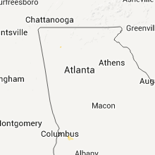
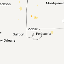
Hail Map for Monday, July 11, 2011

Number of Impacted Households on 7/11/2011
0
Impacted by 1" or Larger Hail
0
Impacted by 1.75" or Larger Hail
0
Impacted by 2.5" or Larger Hail
Square Miles of Populated Area Impacted on 7/11/2011
0
Impacted by 1" or Larger Hail
0
Impacted by 1.75" or Larger Hail
0
Impacted by 2.5" or Larger Hail


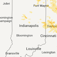


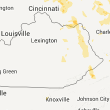


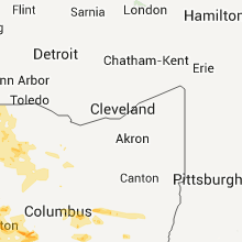


Cities Most Affected by Hail Storms of 7/11/2011
| Hail Size | Demographics of Zip Codes Affected | ||||||
|---|---|---|---|---|---|---|---|
| City | Count | Average | Largest | Pop Density | House Value | Income | Age |
| Gordon, NE | 3 | 2.00 | 2.50 | 2 | $46k | $28.0k | 45.1 |
| Brush, CO | 1 | 1.75 | 1.75 | 22 | $91k | $33.7k | 39.3 |
| Frankfort, IN | 1 | 1.75 | 1.75 | 96 | $83k | $38.3k | 36.5 |
| Springfield, OH | 1 | 1.75 | 1.75 | 1911 | $91k | $40.1k | 41.6 |
| Estelline, TX | 1 | 1.75 | 1.75 | 0 | $20k | $21.9k | 40.5 |
| Lusk, WY | 1 | 1.75 | 1.75 | 0 | $63k | $30.4k | 44.7 |
| South Solon, OH | 1 | 1.75 | 1.75 | 16 | $88k | $39.1k | 39.3 |
| Lakeside, NE | 1 | 1.75 | 1.75 | 0 | $33k | $30.8k | 39.9 |
| Covington, OH | 1 | 1.75 | 1.75 | 122 | $100k | $43.8k | 40.1 |
Hail and Wind Damage Spotted on 7/11/2011
Filter by Report Type:Hail ReportsWind Reports
States Impacted
Illinois, Michigan, Wisconsin, Indiana, Ohio, Pennsylvania, Nebraska, West Virginia, Wyoming, Texas, Maine, Mississippi, Kentucky, Maryland, Virginia, Colorado, Idaho, North Carolina, Arizona, Georgia, TennesseeIllinois
| Local Time | Report Details |
|---|---|
| 12:00 PM UTC | Estimated wind gust outside wrex studi in winnebago county IL, 55.9 miles S of Madison, WI |
| 12:00 PM UTC | Semi overturned. winds sustained for several minute in winnebago county IL, 54.1 miles SSE of Madison, WI |
| 12:09 PM UTC | 12 inch diameter trees dow in lee county IL, 80.6 miles N of Peoria, IL |
| 12:10 PM UTC | 2 large trees blown down - 3 telephone poles severely leaning - corn in the area flattened. half way between creston and in ogle county IL, 69 miles W of Chicago, IL |
| 12:10 PM UTC | Corn fields laying flat and branches 6 inches in diameter down along with power line in ogle county IL, 80 miles S of Madison, WI |
| 12:10 PM UTC | Power lines down blocking eastbound lanes of interstate 90 at county line road on boone and mchenry county lin in boone county IL, 61 miles WNW of Chicago, IL |
| 12:15 PM UTC | 70 to 80 mph winds transformers damaged causing power outage and semi blown on sid in winnebago county IL, 57.9 miles SSE of Madison, WI |
| 12:15 PM UTC | Estimated 70 to 80 mph winds on east side of rockfor in winnebago county IL, 57.9 miles SSE of Madison, WI |
| 12:15 PM UTC | Trees uprooted. semi trailer tipped over and corn flattened. time estimate in fulton county IL, 41.3 miles SW of Peoria, IL |
| 12:15 PM UTC | Rount 251 blocked by downed power lines near spurr r in lee county IL, 71.9 miles NNE of Peoria, IL |
| 12:15 PM UTC | Rt 251 blocked by down power lines near spurr r in lee county IL, 71.9 miles NNE of Peoria, IL |
| 12:17 PM UTC | Multiple reports of trees down in candlewick lake. relayed by wre in boone county IL, 56.4 miles SSE of Madison, WI |
| 12:17 PM UTC | Over 30 large trees down. relayed by wre in boone county IL, 56.4 miles SSE of Madison, WI |
| 12:20 PM UTC | Trees snapped off at the base at annie glidden rd south of rt 38. corn also flattened north and south of de kal in de kalb county IL, 57.7 miles W of Chicago, IL |
| 12:20 PM UTC | Roof blown off of house. garage also destroye in boone county IL, 56.4 miles SSE of Madison, WI |
| 12:28 PM UTC | Sustained wind at 40 to 45 mph. power outages reporte in winnebago county IL, 53.3 miles SSE of Madison, WI |
| 12:28 PM UTC | Trees snappin in de kalb county IL, 57.7 miles W of Chicago, IL |
| 12:30 PM UTC | Intermittant power failure in cook county IL, 28.8 miles WNW of Chicago, IL |
| 12:30 PM UTC | Storm damage reported in dekalb county IL, 55.4 miles W of Chicago, IL |
| 12:30 PM UTC | Delayed report. e60 mph. numerous 12 inch diameter trees down. trees were snapped off clean approximately 30 feet hig in mchenry county IL, 59.6 miles SE of Madison, WI |
| 12:30 PM UTC | Numerous trees and power lines down. one tree fell on a hous in mchenry county IL, 59.6 miles SE of Madison, WI |
| 12:30 PM UTC | Roof blown off of house. garage also destroye in boone county IL, 56.4 miles SSE of Madison, WI |
| 12:30 PM UTC | Large tree down that took down some power lines. state st closed from 9th to divisio in winnebago county IL, 57.9 miles SSE of Madison, WI |
| 12:35 PM UTC | Measured at aurora airpor in kane county IL, 43.4 miles W of Chicago, IL |
| 12:35 PM UTC | Measured with anemometer. tree blown down beith road 1 mile east of rt. 4 in kane county IL, 43.2 miles W of Chicago, IL |
| 12:35 PM UTC | In the meadowbrook neighborhood there are numerous houses with the siding ripped off. multiple trees are uprooted or snapped at the base. one house on waterford lane ha in mchenry county IL, 41.2 miles WNW of Chicago, IL |
| 12:40 PM UTC | Greater than 70 mph winds for 2 to 3 minutes. power outages. 1 ft diameter trees and large branches dow in mchenry county IL, 43.1 miles NW of Chicago, IL |
| 12:40 PM UTC | 70 to 80 mph winds transformers damaged causing power outage and semi blown on sid in winnebago county IL, 57.9 miles SSE of Madison, WI |
| 12:43 PM UTC | Measured at aurora airpor in kane county IL, 43.4 miles W of Chicago, IL |
| 12:47 PM UTC | Transformer damaged with power outage in dupage county IL, 25.8 miles W of Chicago, IL |
| 12:48 PM UTC | 4 to 5 inch diameter tree blown over. estimated winds of 55 mp in kendall county IL, 45.5 miles WSW of Chicago, IL |
| 12:50 PM UTC | Intermittant power failure in cook county IL, 28.8 miles WNW of Chicago, IL |
| 12:50 PM UTC | Sustained 40 to 50 mph wind in dupage county IL, 29.1 miles W of Chicago, IL |
| 12:50 PM UTC | Measured at aurora airpor in kane county IL, 43.4 miles W of Chicago, IL |
| 12:50 PM UTC | 60 to 70 mph gusts and heavy rai in dupage county IL, 29.1 miles W of Chicago, IL |
| 12:50 PM UTC | At the race track 4 to 6 inch branches down. numerous trees and wires down. winds estimated to 70 mp in cook county IL, 22.9 miles NW of Chicago, IL |
| 12:50 PM UTC | Near hintz rd and windsor there are fences blown down and an 8 in diameter tree snappe in cook county IL, 22.9 miles NW of Chicago, IL |
| 12:50 PM UTC | Numerous tree limbs up to 8 inches in diameter dow in lake county IL, 46.5 miles NW of Chicago, IL |
| 12:50 PM UTC | Trees down with power outage in mchenry county IL, 50.9 miles NW of Chicago, IL |
| 12:50 PM UTC | Corn fields laying flat and branches 6 inches in diameter down along with power line in ogle county IL, 80 miles S of Madison, WI |
| 12:51 PM UTC | Window blown out of a house. numerous tree branches dow in cook county IL, 22.9 miles NW of Chicago, IL |
| 12:51 PM UTC | 3 to 4 inch diameter tree limbs snappe in kane county IL, 35.5 miles WNW of Chicago, IL |
| 12:52 PM UTC | Storm damage reported in lake county IL, 32.4 miles NNW of Chicago, IL |
| 12:52 PM UTC | Storm damage reported in kane county IL, 34.8 miles WSW of Chicago, IL |
| 12:54 PM UTC | Storm damage reported in kendall county IL, 38.2 miles WSW of Chicago, IL |
| 12:54 PM UTC | Lots of limbs up to 4 inches in diameter down. some large trees snapped blocking road in lake county IL, 32.7 miles NW of Chicago, IL |
| 12:54 PM UTC | Power lines down blocking eastbound lanes of interstate 90 at county line road on boone and mchenry county lin in boone county IL, 61 miles WNW of Chicago, IL |
| 12:55 PM UTC | Trees blown ove in dupage county IL, 28.1 miles WSW of Chicago, IL |
| 12:55 PM UTC | Large trees down in parts of naperville. relayed by fox chicag in dupage county IL, 28.1 miles WSW of Chicago, IL |
| 12:55 PM UTC | Traffic light down at naperville r in dupage county IL, 28.1 miles WSW of Chicago, IL |
| 12:55 PM UTC | Large tree limbs dow in kane county IL, 37 miles WNW of Chicago, IL |
| 12:56 PM UTC | 12 inch tree fell on a house near the intersection of windser and palitine rd. an 18 inch tree was also uprooted nearby. time estimated based on rada in cook county IL, 26.1 miles NW of Chicago, IL |
| 12:58 PM UTC | Storm damage reported in dupage county IL, 26.7 miles W of Chicago, IL |
| 12:59 PM UTC | Storm damage reported in kane county IL, 34.8 miles WSW of Chicago, IL |
| 12:59 PM UTC | Trees blown ove in dupage county IL, 28.1 miles WSW of Chicago, IL |
| 1:00 PM UTC | Delayed report. shed walls blown in and several large branches dow in will county IL, 32.9 miles SW of Chicago, IL |
| 1:00 PM UTC | 24 inch diameter tree down at the intersection of oakton and wesley. other trees down as wel in cook county IL, 11.8 miles NNW of Chicago, IL |
| 1:00 PM UTC | Large trees down in parts of naperville. relayed by fox chicag in dupage county IL, 28.1 miles WSW of Chicago, IL |
| 1:00 PM UTC | Traffic light down at naperville r in dupage county IL, 28.1 miles WSW of Chicago, IL |
| 1:00 PM UTC | 1 foot diameter branch downed with numerous smaller branches down. harvard st between east and clarenc in cook county IL, 8.1 miles W of Chicago, IL |
| 1:00 PM UTC | Telephone lines down along with large trees in prairie view. a roof is also reported to be blown of in lake county IL, 30.1 miles NW of Chicago, IL |
| 1:01 PM UTC | 15 inch tree uproote in lake county IL, 37.7 miles NNW of Chicago, IL |
| 1:01 PM UTC | Storm damage reported in lake county IL, 32.4 miles NNW of Chicago, IL |
| 1:02 PM UTC | 18 to 24 inch tree branches dow in dupage county IL, 20.8 miles WSW of Chicago, IL |
| 1:04 PM UTC | Storm damage reported in cook county IL, 15.3 miles WNW of Chicago, IL |
| 1:05 PM UTC | Power lines down along with numerous tree branches. 63rd st is blocked from fair view to belmons in dupage county IL, 20.8 miles WSW of Chicago, IL |
| 1:05 PM UTC | Power outages in dupage county IL, 22.1 miles W of Chicago, IL |
| 1:05 PM UTC | Large tree branches dow in dupage county IL, 24.5 miles WSW of Chicago, IL |
| 1:06 PM UTC | 2 foot diameter trees snapped off and utility poles down at the intersection of checker and schaefer in long grov in lake county IL, 28.9 miles NW of Chicago, IL |
| 1:06 PM UTC | 5 to 6 diameter limbs down along 62nd st with a 20 inch diameter tree split vertically down the middl in cook county IL, 12.1 miles SW of Chicago, IL |
| 1:07 PM UTC | Utility poles snapped off and 6 to 8 foot long and 2 to 4 inches in diamete in lake county IL, 42.2 miles NNW of Chicago, IL |
| 1:07 PM UTC | At least six large trees blown down in loyola park section of rogers park near the lakefront. estimated 18 to 24 inch diameter trees. at least 65 mph wind gusts estimat in cook county IL, 8.9 miles NNW of Chicago, IL |
| 1:08 PM UTC | 2 to 4 inch diameter limbs down at the intersection of rt 83 and rt 4 in lake county IL, 32.7 miles NW of Chicago, IL |
| 1:09 PM UTC | At rt 59 and caton rd in will county IL, 34.5 miles WSW of Chicago, IL |
| 1:10 PM UTC | Storm damage reported in cook county IL, 11.8 miles W of Chicago, IL |
| 1:10 PM UTC | 15 foot long branches down about 4 to 6 inches in diameter near wadsworth rd and delaney r in lake county IL, 41.1 miles NNW of Chicago, IL |
| 1:11 PM UTC | Branches 6 to 8 inches in diameter down at the intersection of miller road and route 1 in lake county IL, 31.6 miles NW of Chicago, IL |
| 1:12 PM UTC | Storm damage reported in cook county IL, 12.3 miles SW of Chicago, IL |
| 1:12 PM UTC | Large tree approximately 18 inches in diameter down at the intersection of goethe st and lasalle s in cook county IL, 0.3 miles SSE of Chicago, IL |
| 1:12 PM UTC | 12 inch diameter tree limb down at the intersection of dayton and willo in cook county IL, 3.2 miles N of Chicago, IL |
| 1:12 PM UTC | Large trees down near airport. relayed by fox chicag in cook county IL, 9.4 miles SW of Chicago, IL |
| 1:13 PM UTC | Large branches off trees. wind estimates of near 60 mp in lake county IL, 37.7 miles NNW of Chicago, IL |
| 1:13 PM UTC | 8 inch diameter tree snapped off at the intersection of route 60 and peterson r in lake county IL, 40.5 miles NW of Chicago, IL |
| 1:14 PM UTC | Storm damage reported in cook county IL, 9.4 miles SW of Chicago, IL |
| 1:14 PM UTC | *** 6 inj *** a festival tent at 109th street and 88th avenue near moraine valley community college was lifted and then dropped onto six workers causing minor injurie in cook county IL, 14.8 miles SW of Chicago, IL |
| 1:14 PM UTC | Tent down with multiple victims in cook county IL, 14.8 miles SW of Chicago, IL |
| 1:15 PM UTC | Storm damage reported in cook county IL, 11.8 miles SSW of Chicago, IL |
| 1:15 PM UTC | 12 inch diameter tree dow in cook county IL, 22.9 miles NW of Chicago, IL |
| 1:15 PM UTC | Power poles down on home in cook county IL, 12.2 miles SW of Chicago, IL |
| 1:15 PM UTC | Trees and power lines dow in cook county IL, 12.2 miles SW of Chicago, IL |
| 1:15 PM UTC | Large branches off trees. wind estimates of near 60 mp in lake county IL, 37.7 miles NNW of Chicago, IL |
| 1:15 PM UTC | Semi overturned on 65th and menard. fences blown down along with 10 inch diameter branches. sheet metal and shingles torn off roof in cook county IL, 9.4 miles SW of Chicago, IL |
| 1:15 PM UTC | Multiple tree limbs 3 to 4 inches in diameter dow in lake county IL, 32.7 miles NW of Chicago, IL |
| 1:15 PM UTC | Up to 8 inch tree branches dow in cook county IL, 26.1 miles NW of Chicago, IL |
| 1:16 PM UTC | 4 inch diameter trees dow in dupage county IL, 18.4 miles WSW of Chicago, IL |
| 1:17 PM UTC | 12 to 15 inch diameter tree dow in dupage county IL, 20.2 miles WSW of Chicago, IL |
| 1:17 PM UTC | Delayed report. time approximate. 6 inch diameter limb down with several smaller limbs down throughout the neighborhood. near 169th st and maryland d in cook county IL, 23.3 miles SSW of Chicago, IL |
| 1:18 PM UTC | Storm damage reported in cook county IL, 22.9 miles NW of Chicago, IL |
| 1:19 PM UTC | Trees and power lines dow in cook county IL, 12.2 miles SW of Chicago, IL |
| 1:19 PM UTC | Storm damage reported in cook county IL, 11.9 miles SSW of Chicago, IL |
| 1:20 PM UTC | Power outages to traffic signal in cook county IL, 29.1 miles NW of Chicago, IL |
| 1:21 PM UTC | At the intersection of 88th and utica...there is a 12 inch diameter tree down that snapped off at the bas in cook county IL, 11.9 miles SSW of Chicago, IL |
| 1:22 PM UTC | Semi truck blown over on i94 at rt 17 in lake county IL, 32.3 miles NNW of Chicago, IL |
| 1:27 PM UTC | Some tree damag in cook county IL, 10.9 miles WSW of Chicago, IL |
| 1:28 PM UTC | 6 inch tree limb downe in cook county IL, 0.3 miles SSE of Chicago, IL |
| 1:30 PM UTC | Large tree limbs down in the street in cook county IL, 11.8 miles NNW of Chicago, IL |
| 1:35 PM UTC | 3 inch tree limbs down at intersection of w leland ave and north winchester av in cook county IL, 0.3 miles SSE of Chicago, IL |
| 1:40 PM UTC | Up to 8 inch tree branches dow in cook county IL, 26.1 miles NW of Chicago, IL |
| 1:50 PM UTC | Semi overturned on 65th and menard. fences blown down along with 10 inch diameter branches. sheet metal and shingles torn off roof in cook county IL, 9.4 miles SW of Chicago, IL |
| 1:55 PM UTC | 24 inch diameter tree down at the intersection of oakton and wesley. other trees down as wel in cook county IL, 11.8 miles NNW of Chicago, IL |
| 2:00 PM UTC | Telephone lines down along with large trees in prairie view. a roof is also reported to be blown of in lake county IL, 30.1 miles NW of Chicago, IL |
| 2:01 PM UTC | 15 inch tree uproote in lake county IL, 37.7 miles NNW of Chicago, IL |
| 2:05 PM UTC | Power lines down along with numerous tree branches. 63rd st is blocked from fair view to belmons in dupage county IL, 20.8 miles WSW of Chicago, IL |
| 2:05 PM UTC | Power outages in dupage county IL, 22.1 miles W of Chicago, IL |
| 2:05 PM UTC | Large tree branches dow in dupage county IL, 24.5 miles WSW of Chicago, IL |
| 2:06 PM UTC | 2 foot diameter trees snapped off and utility poles down at the intersection of checker and schaefer in long grov in lake county IL, 28.9 miles NW of Chicago, IL |
| 2:12 PM UTC | Large tree approximately 18 inches in diameter down at the intersection of goethe st and lasalle s in cook county IL, 0.3 miles SSE of Chicago, IL |
| 2:12 PM UTC | 12 inch diameter tree limb down at the intersection of dayton and willo in cook county IL, 3.2 miles N of Chicago, IL |
| 2:14 PM UTC | Numerous trees and power lines down. one tree fell on a hous in mchenry county IL, 59.6 miles SE of Madison, WI |
| 2:17 PM UTC | 12 to 15 inch diameter tree dow in dupage county IL, 20.2 miles WSW of Chicago, IL |
| 2:30 PM UTC | 12 inch diameter tree dow in cook county IL, 22.9 miles NW of Chicago, IL |
| 2:45 PM UTC | Power outages to traffic signal in cook county IL, 29.1 miles NW of Chicago, IL |
| 2:50 PM UTC | At the intersection of 88th and utica...there is a 12 inch diameter tree down that snapped off at the bas in cook county IL, 11.9 miles SSW of Chicago, IL |
Michigan
| Local Time | Report Details |
|---|---|
| 12:00 PM UTC | Tree down on 48th st near osceola county line in lake county MI, 60.5 miles S of Traverse City, MI |
| 12:00 PM UTC | Multiple reports of trees and power lines down in in newaygo county MI, 32.1 miles NNW of Grand Rapids, MI |
| 12:06 PM UTC | Large tree down across whitehall roa in muskegon county MI, 38.5 miles NW of Grand Rapids, MI |
| 12:06 PM UTC | 6 to 8 inch tree branches down at apple avenue and gordon s in muskegon county MI, 32.7 miles NW of Grand Rapids, MI |
| 12:06 PM UTC | 12 inch tree branch down on whitehall roa in muskegon county MI, 36 miles NW of Grand Rapids, MI |
| 12:10 PM UTC | Numerous trees down at apple ave and us 31 in muskegon county MI, 33.2 miles NW of Grand Rapids, MI |
| 12:25 PM UTC | Strong thunderstorm winds blew a large tree on a house and did significant damage to roof and second floor of the hom in kent county MI, 7.2 miles SW of Grand Rapids, MI |
| 12:27 PM UTC | Storm damage reported in kent county MI, 2.6 miles NW of Grand Rapids, MI |
| 12:50 PM UTC | Trees fell on trailer at 14000 block of sparta ave. time estimated by rada in kent county MI, 18 miles NNW of Grand Rapids, MI |
| 12:50 PM UTC | Northbound us-31 at white lake drive and southbound us-31 at colby street closed due to trees down over road in muskegon county MI, 44.9 miles NW of Grand Rapids, MI |
| 12:56 PM UTC | One foot diameter tree is down. the health is unknow in mecosta county MI, 39.3 miles NNE of Grand Rapids, MI |
| 12:59 PM UTC | Spotter reports several 3 inch healthy tree limbs dow in oceana county MI, 61.4 miles NW of Grand Rapids, MI |
| 1:00 PM UTC | Powerl lines down at fillmore and 144th st. trees in road at kisler and morton and 48th and stoney lak in oceana county MI, 61.4 miles NW of Grand Rapids, MI |
| 1:30 PM UTC | Multiple reports of trees and power lines down in in newaygo county MI, 32.1 miles NNW of Grand Rapids, MI |
| 1:30 PM UTC | Several trees and power lines dow in kent county MI, 0.5 miles WNW of Grand Rapids, MI |
| 1:37 PM UTC | Tree down on 48th st near osceola county line in lake county MI, 60.5 miles S of Traverse City, MI |
| 2:00 PM UTC | Power lines dow in ottawa county MI, 25.7 miles WSW of Grand Rapids, MI |
| 2:05 PM UTC | Time estimated from rada in berrien county MI, 61.5 miles ENE of Chicago, IL |
| 2:10 PM UTC | 53 knot wind gust at benton harbor airport in berrien county MI, 63.9 miles ENE of Chicago, IL |
| 2:14 PM UTC | Trees and power lines down in berrien county MI, 66.8 miles E of Chicago, IL |
| 2:16 PM UTC | Spotter reports 3 foot diameter healthy trees upr in allegan county MI, 31.6 miles SSW of Grand Rapids, MI |
| 2:16 PM UTC | Tree down in kent county MI, 18.6 miles NNW of Grand Rapids, MI |
| 2:18 PM UTC | Van buren county sheriffs department reports numerous areas of tree damage across the county. the city of hartford sustained tree damage as well as mattawan. widespread in van buren county MI, 58.1 miles SSW of Grand Rapids, MI |
| 2:20 PM UTC | Tree down on centerlake in barry county MI, 29.2 miles SE of Grand Rapids, MI |
| 2:20 PM UTC | Trees and branches down in millburg. time estimated from rada in berrien county MI, 67.7 miles SSW of Grand Rapids, MI |
| 2:25 PM UTC | 12 inch diameter tree down blocking 400 block of ridgeway in downtown st. joseph. time estimated from rada in berrien county MI, 61.3 miles ENE of Chicago, IL |
| 2:25 PM UTC | 3 ft diameter tree down blocking 800 block of wolcott. time estimated from rada in berrien county MI, 61.3 miles ENE of Chicago, IL |
| 2:26 PM UTC | Large 18-24 inch diameter tree down across fir road just north of the state line. time estimated from rada in cass county MI, 73 miles NW of Fort Wayne, IN |
| 2:26 PM UTC | Lines down at 32nd and barry in hudsonville and park townshi in ottawa county MI, 24.5 miles W of Grand Rapids, MI |
| 2:29 PM UTC | Also 4 to 5 trees in ottawa county MI, 25.8 miles WSW of Grand Rapids, MI |
| 2:29 PM UTC | Also 8 power poles down. one snapped in half. downtown holland without powe in ottawa county MI, 23.8 miles WSW of Grand Rapids, MI |
| 2:29 PM UTC | A six inch healthy limb came down. time is radar estimate in ottawa county MI, 25.2 miles WSW of Grand Rapids, MI |
| 2:29 PM UTC | A three inch healthy birch tree is down near 32nd and wildwood. time is estimated from rada in allegan county MI, 29.2 miles WSW of Grand Rapids, MI |
| 2:30 PM UTC | Measured at the holland nos sit in allegan county MI, 30.1 miles WSW of Grand Rapids, MI |
| 2:30 PM UTC | Numerous trees and power lines down. many trees down on house in ottawa county MI, 25.4 miles WSW of Grand Rapids, MI |
| 2:32 PM UTC | Approximately 20 to 25 pine trees were blown down on one property off 64th avenu in van buren county MI, 54.9 miles S of Grand Rapids, MI |
| 2:34 PM UTC | Roof taken off ballfield dugout. cinder blocks blown 30 fee in van buren county MI, 55.7 miles S of Grand Rapids, MI |
| 2:35 PM UTC | Estimated wind gust in downtown holland. pea size hail was also reporte in ottawa county MI, 25.7 miles WSW of Grand Rapids, MI |
| 2:38 PM UTC | Approximately 30 reports of power lines and trees dow in ottawa county MI, 25.7 miles WSW of Grand Rapids, MI |
| 2:38 PM UTC | Power lines and trees down as well as residence damage. time estimated by rada in ottawa county MI, 24.5 miles W of Grand Rapids, MI |
| 2:42 PM UTC | Vaccuums at car wash blown over. time estimated by rada in muskegon county MI, 32.3 miles NW of Grand Rapids, MI |
| 2:42 PM UTC | Vaccuums blown over at car was in muskegon county MI, 32.3 miles NW of Grand Rapids, MI |
| 2:47 PM UTC | Multiple trees down 2 miles north of us 12 on highway 40. time estimated from rada in cass county MI, 64.1 miles NW of Fort Wayne, IN |
| 2:50 PM UTC | Storm damage reported in kalamazoo county MI, 58.4 miles S of Grand Rapids, MI |
| 2:52 PM UTC | Trees and limbs down in the area. one 8 inch branch blocking riverside drive just west of blue school road in constantin in st. joseph county MI, 60.2 miles NNW of Fort Wayne, IN |
| 2:53 PM UTC | Lots of damage. estimated time from rada in kalamazoo county MI, 53.8 miles S of Grand Rapids, MI |
| 2:54 PM UTC | Also 0.41 inches of rai in ottawa county MI, 29.8 miles WSW of Grand Rapids, MI |
| 2:55 PM UTC | Multiple trees and power lines down throughout three rivers in st. joseph county MI, 65.7 miles NNW of Fort Wayne, IN |
| 2:57 PM UTC | Tree limbs down. 5-6 inch diameter healthy tree through roof of house. time estimated by rada in kent county MI, 6.2 miles SE of Grand Rapids, MI |
| 2:57 PM UTC | Dozens of trees down. no damage to residence in kent county MI, 7.5 miles SSE of Grand Rapids, MI |
| 2:57 PM UTC | *** 1 inj *** a woman suffered minor injuries when a tree fell on her home. report via woodtv. time estimated by rada in kent county MI, 7.5 miles SSE of Grand Rapids, MI |
| 2:57 PM UTC | Power lines in kent county MI, 7.5 miles SSE of Grand Rapids, MI |
| 2:57 PM UTC | Eastern avenue closed between pembroke st and diane st due to powerlines down across the roadway. time estimated by rada in kent county MI, 6.8 miles SSE of Grand Rapids, MI |
| 2:57 PM UTC | Tree down in kent county MI, 18.6 miles NNW of Grand Rapids, MI |
| 2:58 PM UTC | A one foot diameter tree top snapped off near cascade rd and spaulding ave. estimated wind speed was 60 mp in kent county MI, 6.9 miles ESE of Grand Rapids, MI |
| 3:00 PM UTC | Also 8 power poles down. one snapped in half. downtown holland without powe in ottawa county MI, 23.8 miles WSW of Grand Rapids, MI |
| 3:00 PM UTC | 2 trees down and part of a commercial building roof blown of in berrien county MI, 63 miles ENE of Chicago, IL |
| 3:00 PM UTC | Tree down on centerlake in barry county MI, 29.2 miles SE of Grand Rapids, MI |
| 3:01 PM UTC | Power lines down with trees in roadway...at nottawwa and anne st. time estimated from rada in st. joseph county MI, 62.4 miles NNW of Fort Wayne, IN |
| 3:02 PM UTC | Also 4 to 5 trees in ottawa county MI, 25.8 miles WSW of Grand Rapids, MI |
| 3:05 PM UTC | A one foot diameter tree came dow in kent county MI, 16.3 miles SE of Grand Rapids, MI |
| 3:07 PM UTC | Trees dow in kent county MI, 8.1 miles S of Grand Rapids, MI |
| 3:08 PM UTC | Multiple trees and lines down at custer and decker road. time estimated from rada in st. joseph county MI, 62.1 miles N of Fort Wayne, IN |
| 3:08 PM UTC | Power lines down...with transformer fires on the east side of sturgi in st. joseph county MI, 52.7 miles NNW of Fort Wayne, IN |
| 3:10 PM UTC | Flagpole bent over. also three pieces of fence blown ove in kent county MI, 8.4 miles SSE of Grand Rapids, MI |
| 3:12 PM UTC | 10 inch limbs down. most of the streets in paw paw are floode in van buren county MI, 52.7 miles SSW of Grand Rapids, MI |
| 3:12 PM UTC | 10 inch limbs down. most of the streets in paw paw are floode in berrien county MI, 62.2 miles SSW of Grand Rapids, MI |
| 3:15 PM UTC | Barn damaged and billboard blown down. event time correcte in branch county MI, 67.2 miles SSE of Grand Rapids, MI |
| 3:16 PM UTC | Pine trees on power in kent county MI, 7.1 miles SSE of Grand Rapids, MI |
| 3:18 PM UTC | Roof taken off ballfield dugout. cinder blocks blown 30 fee in van buren county MI, 55.7 miles S of Grand Rapids, MI |
| 3:19 PM UTC | One foot diameter healthy tree branch snapped off. no damage or injuries. time is radar estimate in calhoun county MI, 53.9 miles SSE of Grand Rapids, MI |
| 3:25 PM UTC | *** 1 fatal *** tree fell on house. one confirmed fatalit in kent county MI, 8.8 miles S of Grand Rapids, MI |
| 3:25 PM UTC | Several tree branches dow in kent county MI, 8.8 miles S of Grand Rapids, MI |
| 3:45 PM UTC | Trees down and some power outages across the count in hillsdale county MI, 63.2 miles NNE of Fort Wayne, IN |
| 4:00 PM UTC | Trees and wires/poles down in livingston county MI, 31.1 miles SW of Flint, MI |
| 4:08 PM UTC | Tree in kalamazoo county MI, 53.8 miles S of Grand Rapids, MI |
| 4:10 PM UTC | Barn damaged and billboard blown dow in branch county MI, 67.2 miles SSE of Grand Rapids, MI |
| 4:11 PM UTC | 2 ft diameter tree down across road. mostly rotten on insid in calhoun county MI, 58.2 miles SSE of Grand Rapids, MI |
| 4:14 PM UTC | Several roads covered by tree in van buren county MI, 58.1 miles SSW of Grand Rapids, MI |
| 4:25 PM UTC | Storm damage reported in washtenaw county MI, 50.5 miles S of Flint, MI |
| 4:25 PM UTC | Damage to roof of shed and small branches down. winds estimated to 60 mp in washtenaw county MI, 56.8 miles S of Flint, MI |
| 4:29 PM UTC | Two trees down in lenawee county MI, 70.3 miles S of Flint, MI |
| 4:32 PM UTC | Storm damage reported in washtenaw county MI, 60.3 miles S of Flint, MI |
| 4:33 PM UTC | Many trees and power lines down including a 35 inch diameter tre in wayne county MI, 49.5 miles SSE of Flint, MI |
| 4:37 PM UTC | Large tree limb down on roof of house in wayne county MI, 50.2 miles SSE of Flint, MI |
| 4:41 PM UTC | Branches down up to 8 inches in diameter in wayne county MI, 51.2 miles SSE of Flint, MI |
| 4:46 PM UTC | Limbs down up to one foot diameter in wayne county MI, 54.1 miles SSE of Flint, MI |
| 4:46 PM UTC | Large tree branch down on will carleton roa in monroe county MI, 65.4 miles SSE of Flint, MI |
| 4:48 PM UTC | Power o in wayne county MI, 50.3 miles SSE of Flint, MI |
| 4:49 PM UTC | Large tree and powerlines dow in macomb county MI, 49.9 miles SE of Flint, MI |
Wisconsin
| Local Time | Report Details |
|---|---|
| 12:09 PM UTC | Screen house torn apart bending 1 inch square steel tubes. wind measured at 30 mph. measured rainfall 0.48 inche in rock county WI, 36.3 miles SSE of Madison, WI |
| 12:20 PM UTC | Storm damage reported in rock county WI, 42.5 miles SSE of Madison, WI |
| 12:25 PM UTC | Power lines down. estimated wind gust of 55 mp in rock county WI, 20.7 miles SSE of Madison, WI |
| 12:25 PM UTC | Power lines down. estimated wind gust of 55 mp in rock county WI, 23.2 miles SSE of Madison, WI |
| 12:35 PM UTC | Power lines blocking all four lanes of hwy 51 near the airport. four inch diameter branches and eight inch diameter tree down. estimated wind gust of 55 mp in rock county WI, 35.8 miles SSE of Madison, WI |
| 12:50 PM UTC | About a dozen trees down across the western half of kenosha count in kenosha county WI, 52.1 miles NNW of Chicago, IL |
| 12:50 PM UTC | 1 ft diameter healthy tree branch found on garage roof...time estimated from radar in jefferson county WI, 29.9 miles ESE of Madison, WI |
| 1:02 PM UTC | Storm damage reported in walworth county WI, 36.8 miles ESE of Madison, WI |
| 1:02 PM UTC | 30 ft maple uprooted...about 3 foot diameter...time estimated from radar in jefferson county WI, 42.3 miles ESE of Madison, WI |
| 1:02 PM UTC | Multiple 6-12 ft long branches covering road...tree branch down on day care center corner of cty rd h and blue spring lake dr...time estimated from radar in jefferson county WI, 42.3 miles ESE of Madison, WI |
| 1:02 PM UTC | Multiple 6-12 ft long branches covering road...tree down on day care center corner of cty rd h and blue spring lake dr...time estimated from radar in jefferson county WI, 42.3 miles ESE of Madison, WI |
| 1:12 PM UTC | Storm damage reported in kenosha county WI, 49 miles N of Chicago, IL |
| 1:12 PM UTC | Numerous small branches down 2 inches or less in diamete in kenosha county WI, 49 miles N of Chicago, IL |
| 1:15 PM UTC | Many 4-5 five inch tree limbs down through the area in rock county WI, 24.3 miles SE of Madison, WI |
| 1:30 PM UTC | Numerous 12 to 18 inch diameter trees down across the northern half of the city in waukesha county WI, 58.1 miles E of Madison, WI |
Indiana
| Local Time | Report Details |
|---|---|
| 1:55 PM UTC | Storm damage reported in lmz046 county IN, 38.6 miles ESE of Chicago, IL |
| 1:55 PM UTC | Reports of trees and powerlines down in michigan city...time estimated from rada in laporte county IN, 39.7 miles ESE of Chicago, IL |
| 2:10 PM UTC | Storm damage reported in laporte county IN, 50.8 miles ESE of Chicago, IL |
| 2:20 PM UTC | 12 inch diameter oak tree snapped...us 20 near tamarack in st. joseph county IN, 59.3 miles ESE of Chicago, IL |
| 2:22 PM UTC | Storm damage reported in st. joseph county IN, 72.8 miles E of Chicago, IL |
| 2:23 PM UTC | Measured 68 mph wind gust at wndv radi in st. joseph county IN, 72.8 miles E of Chicago, IL |
| 2:24 PM UTC | Trees and power lines reported down across the county by dispatc in st. joseph county IN, 72.8 miles E of Chicago, IL |
| 2:25 PM UTC | Storm damage reported in st. joseph county IN, 71.2 miles NW of Fort Wayne, IN |
| 2:25 PM UTC | Numerous trees and power lines down...time estimated from rada in st. joseph county IN, 73.2 miles E of Chicago, IL |
| 2:33 PM UTC | Time estimated from rada in st. joseph county IN, 66.3 miles NW of Fort Wayne, IN |
| 2:33 PM UTC | A few trees and many limbs down citywide. time estimated from rada in st. joseph county IN, 68.3 miles NW of Fort Wayne, IN |
| 2:34 PM UTC | Estimated one foot diameter branch down in st. joseph county IN, 65.4 miles NW of Fort Wayne, IN |
| 2:34 PM UTC | 6 inch diameter branches down in st. joseph county IN, 67.1 miles NW of Fort Wayne, IN |
| 2:53 PM UTC | Tree down at county road 16 and us 20. tree is blocking us 2 in elkhart county IN, 52.5 miles NW of Fort Wayne, IN |
| 2:55 PM UTC | Estimated 60 to 65 mph wind gust in elkhart county IN, 43.8 miles NW of Fort Wayne, IN |
| 3:00 PM UTC | Many 8 inch plus diameter tree branches on the ground near menards at 601 windsor av in elkhart county IN, 63.9 miles NW of Fort Wayne, IN |
| 3:01 PM UTC | Multiple trees...up to 2 foot in diameter snapped at howe military academ in lagrange county IN, 47.5 miles NNW of Fort Wayne, IN |
| 3:01 PM UTC | Tree branches down between cr 15 and 19 south of the toll roa in elkhart county IN, 62.5 miles NW of Fort Wayne, IN |
| 3:06 PM UTC | Multiple telephone poles down. time estimated from rada in kosciusko county IN, 41 miles NW of Fort Wayne, IN |
| 3:25 PM UTC | 8 reports of trees and power lines down obstructing roads across the county. time estimated based on rada in noble county IN, 27.9 miles NW of Fort Wayne, IN |
| 3:30 PM UTC | Estimated 50 to 60 mph winds. 4 to 5 inch tree limbs dow in dekalb county IN, 20.4 miles N of Fort Wayne, IN |
| 3:30 PM UTC | Trees and power lines down all across steuben count in steuben county IN, 38.6 miles N of Fort Wayne, IN |
| 3:31 PM UTC | Semi trailer blown over on interstate 69 near mile marker 139. time estimated from rada in dekalb county IN, 31.4 miles N of Fort Wayne, IN |
| 3:33 PM UTC | 3 inch diameter tree down. corrected event tim in whitley county IN, 21.2 miles WNW of Fort Wayne, IN |
| 3:33 PM UTC | Semi trailer blown over on interstate 69 at mile marker 12 in de kalb county IN, 21.1 miles N of Fort Wayne, IN |
| 3:35 PM UTC | 5 inch diameter top half of tree down blocking the road...near sr 827 and 300 e. time estimated from rada in steuben county IN, 44.6 miles N of Fort Wayne, IN |
| 3:42 PM UTC | 3 inch diameter tree dow in whitley county IN, 21.2 miles WNW of Fort Wayne, IN |
| 3:51 PM UTC | Light structural damage and several limbs and branches down across waynedal in allen county IN, 5.7 miles SW of Fort Wayne, IN |
| 3:55 PM UTC | Tree down into power lines and on top of house at fruit and wesley street on the east side of huntington. power outages reported in that area. time estimated from radar in huntington county IN, 24.9 miles WSW of Fort Wayne, IN |
| 4:00 PM UTC | Tree and power lines reported down across fort wayn in allen county IN, 1.6 miles W of Fort Wayne, IN |
| 4:01 PM UTC | Tree down on a house. time estimated from rada in allen county IN, 2 miles NNE of Fort Wayne, IN |
| 11:55 PM UTC | Storm damage reported in howard county IN, 46.3 miles N of Indianapolis, IN |
| 12:17 AM UTC | Quarter sized hail reported near Winchester, IN, 64.6 miles S of Fort Wayne, IN |
| 12:34 AM UTC | Golf Ball sized hail reported near Frankfort, IN, 47.2 miles NNW of Indianapolis, IN, relayed by clinton county sheriffs office. |
| 12:40 AM UTC | Quarter sized hail reported near Lynn, IN, 65.8 miles NNW of Cincinnati, OH |
| 1:13 AM UTC | Trees reported down at 286th street and horton road...as well as 286th street and dunbar road. power lines were also reported down in the northwest portion of hamilton in hamilton county IN, 30.6 miles N of Indianapolis, IN |
| 1:24 AM UTC | Downed tree and telephone pole on 236th street...north of demin in hamilton county IN, 24.5 miles N of Indianapolis, IN |
| 1:26 AM UTC | Tree reported over the road near 225th street and hinkel roa in hamilton county IN, 23.2 miles N of Indianapolis, IN |
| 1:29 AM UTC | Downed trees and a telephone pole in cicer in hamilton county IN, 25.3 miles NNE of Indianapolis, IN |
| 1:32 AM UTC | 4 trees fell on a house. numerous other trees down on cook road from sr 227 to state line. time estimate in wayne county IN, 56.6 miles NNW of Cincinnati, OH |
| 1:35 AM UTC | Downed trees on 191st street and victory chapel roa in hamilton county IN, 23.8 miles NNE of Indianapolis, IN |
| 1:36 AM UTC | House with roof damage and a trailer pushed onto porch. corrected tim in wayne county IN, 54 miles NNW of Cincinnati, OH |
| 1:36 AM UTC | Roof blown off the press box and a dugout at mcbride stadiu in wayne county IN, 54.6 miles NNW of Cincinnati, OH |
| 2:33 AM UTC | House with roof damage and a trailer pushed onto porc in wayne county IN, 54 miles NNW of Cincinnati, OH |
Ohio
| Local Time | Report Details |
|---|---|
| 3:50 PM UTC | Several 3-5 inch diameter tree limbs down at sycamore springs golf cours in hancock county OH, 75.4 miles NNW of Columbus, OH |
| 4:00 PM UTC | Large limbs dow in wood county OH, 78.4 miles ENE of Fort Wayne, IN |
| 4:05 PM UTC | Trees down and power outage in hancock county OH, 68.4 miles E of Fort Wayne, IN |
| 4:05 PM UTC | Trees in hancock county OH, 68.4 miles E of Fort Wayne, IN |
| 4:06 PM UTC | 71 mph wind gust recorded at paulding ema office in paulding county OH, 27.5 miles E of Fort Wayne, IN |
| 4:10 PM UTC | Tree fell onto a house at river and madison streets. multiple trees reported down throughout antwerp. time estimated from rada in paulding county OH, 20.1 miles ENE of Fort Wayne, IN |
| 4:18 PM UTC | Estimated wind gusts 55-65 mph. time estimated from rada in henry county OH, 54.2 miles ENE of Fort Wayne, IN |
| 4:22 PM UTC | Estimated 65mph wind gust in hancock county OH, 76.3 miles E of Fort Wayne, IN |
| 4:43 PM UTC | Power pole and transformer blown down in fort jennings. time estimated from rada in putnam county OH, 43.3 miles ESE of Fort Wayne, IN |
| 4:47 PM UTC | A few branches and one tree down in columbus grove. time estimated from rada in putnam county OH, 55.4 miles E of Fort Wayne, IN |
| 4:47 PM UTC | Estimated 65 mph with large tree branches down. also flash flooding occurrin in lucas county OH, 81.4 miles ENE of Fort Wayne, IN |
| 4:48 PM UTC | Measured 63 mph wind gus in lucas county OH, 88.7 miles ENE of Fort Wayne, IN |
| 4:57 PM UTC | 54 kt gust measured at the lima allen county airpor in allen county OH, 61.4 miles ESE of Fort Wayne, IN |
| 5:00 PM UTC | Small tree branches dow in allen county OH, 56.7 miles ESE of Fort Wayne, IN |
| 5:04 PM UTC | 2 large trees down along crawford-wyandot county lin in crawford county OH, 57.9 miles N of Columbus, OH |
| 5:15 PM UTC | Several trees down across western part of county in hardin county OH, 68.3 miles NW of Columbus, OH |
| 5:16 PM UTC | 5 large branches down alomg with unusual floodin in sandusky county OH, 76.3 miles W of Cleveland, OH |
| 5:18 PM UTC | Estimated 50 mph wind gus in richland county OH, 60.5 miles NNE of Columbus, OH |
| 5:27 PM UTC | Structural damag in richland county OH, 60.5 miles NNE of Columbus, OH |
| 5:28 PM UTC | Large branches broke in richland county OH, 60.5 miles NNE of Columbus, OH |
| 5:30 PM UTC | Multiple trees down east of care in wyandot county OH, 70.2 miles NNW of Columbus, OH |
| 5:40 PM UTC | A couple of trees and some powerlines down near lakeview and harpe in logan county OH, 61.1 miles NW of Columbus, OH |
| 5:45 PM UTC | Large branches and small trees down along state route 51 in ashland county OH, 60.7 miles NE of Columbus, OH |
| 5:50 PM UTC | One tree dow in knox county OH, 43 miles NNE of Columbus, OH |
| 5:53 PM UTC | Trees dow in huron county OH, 62.1 miles WSW of Cleveland, OH |
| 5:58 PM UTC | 1 tree down in shelby county OH, 64.6 miles WNW of Columbus, OH |
| 6:00 PM UTC | Large 8 inch diameter tree dow in stark county OH, 50.8 miles SSE of Cleveland, OH |
| 6:00 PM UTC | A few trees and powerlines down between marysville and plain city in union county OH, 27.3 miles NW of Columbus, OH |
| 6:09 PM UTC | Tree and power lines down near township rd 206 in tiverton townshi in coshocton county OH, 54.8 miles ENE of Columbus, OH |
| 6:20 PM UTC | Storm damage reported in licking county OH, 21.1 miles NE of Columbus, OH |
| 6:35 PM UTC | One tree dow in knox county OH, 51.8 miles NE of Columbus, OH |
| 6:35 PM UTC | A few trees and powerlines down in licking county OH, 21.4 miles E of Columbus, OH |
| 6:47 PM UTC | Estimated 59 mph wind gust in doylestow in wayne county OH, 36.9 miles S of Cleveland, OH |
| 6:48 PM UTC | Large branches broke in perry county OH, 38.2 miles E of Columbus, OH |
| 6:48 PM UTC | Trees dow in perry county OH, 38.2 miles E of Columbus, OH |
| 6:50 PM UTC | Measured 60 mph wind gust in stark county OH, 55 miles S of Cleveland, OH |
| 6:59 PM UTC | Storm damage reported in stark county OH, 50.8 miles SSE of Cleveland, OH |
| 7:00 PM UTC | Large branches broke in perry county OH, 46.6 miles ESE of Columbus, OH |
| 7:00 PM UTC | Golf Ball sized hail reported near Springfield, OH, 42.4 miles W of Columbus, OH, 2615 high st. near hospital. |
| 7:06 PM UTC | Trees down in tuscarawas county OH, 64.8 miles SSE of Cleveland, OH |
| 7:09 PM UTC | Quarter sized hail reported near East Fultonham, OH, 47.5 miles E of Columbus, OH |
| 7:10 PM UTC | Multiple 6-8 inch diameter tree limbs down as well as power lines dow in stark county OH, 50.8 miles SSE of Cleveland, OH |
| 7:10 PM UTC | Numerous trees down and power poles snapped off 4 ft above groun in clark county OH, 41.1 miles W of Columbus, OH |
| 7:15 PM UTC | One large tree down on irish ridge road in muskingum county OH, 58.5 miles E of Columbus, OH |
| 7:18 PM UTC | Trees and power lines down countywide in carroll county OH, 58.3 miles W of Pittsburgh, PA |
| 7:21 PM UTC | Large branches broke in morgan county OH, 68.2 miles ESE of Columbus, OH |
| 7:22 PM UTC | Several 6-8 inch limbs in stark county OH, 50.7 miles SE of Cleveland, OH |
| 7:30 PM UTC | Golf Ball sized hail reported near South Solon, OH, 35.7 miles WSW of Columbus, OH |
| 7:36 PM UTC | Trees and power lines down in columbiana county OH, 54.3 miles WNW of Pittsburgh, PA |
| 7:44 PM UTC | Large branches broke in athens county OH, 66.7 miles SE of Columbus, OH |
| 7:45 PM UTC | Large tree down in noble county OH, 83.6 miles WSW of Pittsburgh, PA |
| 7:45 PM UTC | Couple of trees down in noble county OH, 78 miles ESE of Columbus, OH |
| 7:45 PM UTC | Numerous trees down around the town of waterford in washington county OH, 77.9 miles ESE of Columbus, OH |
| 7:48 PM UTC | Half Dollar sized hail reported near Jeffersonville, OH, 37.2 miles WSW of Columbus, OH |
| 7:51 PM UTC | Multiple trees down in belmont county OH, 53.9 miles WSW of Pittsburgh, PA |
| 7:51 PM UTC | Multiple trees down in belmont county OH, 60.1 miles WSW of Pittsburgh, PA |
| 7:54 PM UTC | Quarter sized hail reported near Lowell, OH, 83.7 miles ESE of Columbus, OH |
| 7:55 PM UTC | Trees and power lines down countywide in belmont county OH, 53.7 miles WSW of Pittsburgh, PA |
| 7:55 PM UTC | Trees and power lines down countywide in jefferson county OH, 33.7 miles W of Pittsburgh, PA |
| 8:01 PM UTC | Quarter sized hail reported near Washington Court House, OH, 36.9 miles SW of Columbus, OH |
| 8:08 PM UTC | Quarter sized hail reported near Marietta, OH, 74 miles N of Charleston, WV |
| 8:25 PM UTC | Large tree down in monroe county OH, 75.7 miles SW of Pittsburgh, PA |
| 8:28 PM UTC | Trees down in jefferson county OH, 33.3 miles WSW of Pittsburgh, PA |
| 8:30 PM UTC | Trees and power lines down across the county...primarily north of moundsville in noble county OH, 83.5 miles ESE of Columbus, OH |
| 8:30 PM UTC | Half Dollar sized hail reported near Sabina, OH, 49.5 miles SW of Columbus, OH |
| 8:55 PM UTC | Quarter sized hail reported near Hillsboro, OH, 49.1 miles E of Cincinnati, OH |
| 9:00 PM UTC | Ping Pong Ball sized hail reported near Hillsboro, OH, 46.4 miles E of Cincinnati, OH |
| 9:07 PM UTC | Quarter sized hail reported near Hillsboro, OH, 48.6 miles E of Cincinnati, OH |
| 9:15 PM UTC | Trees down in rosemont and numerous other locations in the count in scioto county OH, 78.2 miles WNW of Charleston, WV |
| 10:09 PM UTC | Tree down on rte 23 in scioto county OH, 80.5 miles WNW of Charleston, WV |
| 11:50 PM UTC | Ping Pong Ball sized hail reported near Covington, OH, 71.5 miles W of Columbus, OH, corrected covington oh report from 1.75 to 1.50. |
| 11:50 PM UTC | Golf Ball sized hail reported near Covington, OH, 70.4 miles N of Cincinnati, OH |
| 11:55 PM UTC | Quarter sized hail reported near Piqua, OH, 67.4 miles WNW of Columbus, OH |
| 11:55 PM UTC | Quarter sized hail reported near Troy, OH, 65.8 miles W of Columbus, OH |
| 12:00 AM UTC | 3 inch diameter limbs dow in miami county OH, 70.4 miles N of Cincinnati, OH |
| 12:23 AM UTC | Trees down. route 127 north of eaton had several power poles across the roadway. trees were also blown down in the lewisburg are in preble county OH, 54.2 miles NNW of Cincinnati, OH |
| 12:36 AM UTC | Quarter sized hail reported near Vandalia, OH, 58.6 miles NNE of Cincinnati, OH |
| 12:36 AM UTC | Trees down in muskingum county OH, 61.5 miles E of Columbus, OH |
| 12:41 AM UTC | Recorded at wright-patterson air force bas in greene county OH, 55.5 miles NNE of Cincinnati, OH |
| 12:41 AM UTC | Trees down on weavers fort jefferson road. time is estimate in darke county OH, 64.3 miles N of Cincinnati, OH |
| 8:42 PM EDT | Quarter sized hail reported near Huber Heights, OH, 56.5 miles NNE of Cincinnati, OH, reported from huber heights. |
| 12:43 AM UTC | Quarter sized hail reported near Huber Heights, OH, 56.1 miles NNE of Cincinnati, OH |
| 12:45 AM UTC | Multiple tree bra in greene county OH, 54.4 miles NNE of Cincinnati, OH |
| 12:48 AM UTC | A 12-inch diameter tree branch was downe in montgomery county OH, 55.7 miles N of Cincinnati, OH |
| 12:57 AM UTC | Storm damage reported in montgomery county OH, 55.9 miles NNE of Cincinnati, OH |
| 12:57 AM UTC | Power lines and wires were blown down on otterbein ithaca road. time is estimate in darke county OH, 58.8 miles N of Cincinnati, OH |
| 12:59 AM UTC | Large branches broke in montgomery county OH, 51.2 miles NNE of Cincinnati, OH |
| 1:00 AM UTC | Large tree uproote in montgomery county OH, 49.6 miles NNE of Cincinnati, OH |
| 1:04 AM UTC | Numerous large tree limbs downed in the road. report is from the culver road and watervliet road area of dayto in montgomery county OH, 46.8 miles NNE of Cincinnati, OH |
| 1:09 AM UTC | Quarter sized hail reported near , , 63.5 miles NNW of Cincinnati, OH |
| 1:18 AM UTC | Tree down bocking road wesley chapel roa in fayette county OH, 32.9 miles WSW of Columbus, OH |
| 1:23 AM UTC | Two roofs off of two apartment buildings blown into neighboring yard. wood oak apartments on woodman drive. numerous trees and power poles down throughout eastern kette in montgomery county OH, 45.1 miles NNE of Cincinnati, OH |
| 1:23 AM UTC | Trees down. route 127 north of eaton had several power poles across the roadway. trees were also blown down in the lewisburg are in preble county OH, 54.2 miles NNW of Cincinnati, OH |
| 1:23 AM UTC | Large branches dow in montgomery county OH, 47.1 miles NNE of Cincinnati, OH |
| 1:27 AM UTC | Healthy tree branch 12 inch diameter snapped at base in montgomery county OH, 55.7 miles N of Cincinnati, OH |
| 1:27 AM UTC | Tree down at 3036 st rte 4 in fayette county OH, 36.4 miles SW of Columbus, OH |
| 1:29 AM UTC | One large tree 30 feet in clinton county OH, 43.6 miles NE of Cincinnati, OH |
| 1:30 AM UTC | Several tree limbs down in montgomery county OH, 45.1 miles NNE of Cincinnati, OH |
| 1:32 AM UTC | Trees dow in fayette county OH, 32.2 miles SW of Columbus, OH |
| 1:36 AM UTC | Horse shelter destroye in clinton county OH, 37.6 miles ENE of Cincinnati, OH |
| 1:38 AM UTC | 4 to 6 inch diameter tree limbs down in montgomery county OH, 39.3 miles NNE of Cincinnati, OH |
| 1:40 AM UTC | Multiple trees dow in montgomery county OH, 45.1 miles NNE of Cincinnati, OH |
| 1:40 AM UTC | Tree limbs down in greene county OH, 46.6 miles NNE of Cincinnati, OH |
| 1:41 AM UTC | Storm damage reported in montgomery county OH, 45.1 miles NNE of Cincinnati, OH |
| 1:48 AM UTC | Half inch hail occurred as wel in greene county OH, 49.1 miles NNE of Cincinnati, OH |
| 1:49 AM UTC | Large branches broke in ross county OH, 45.9 miles SSW of Columbus, OH |
| 1:50 AM UTC | Several power poles and large limbs dow in montgomery county OH, 45.1 miles NNE of Cincinnati, OH |
| 1:55 AM UTC | One tree snapped off with a trunk diameter of about four feet. numerous large limbs blocking fordyce roa in ross county OH, 48.8 miles SSW of Columbus, OH |
| 1:56 AM UTC | Storm damage reported in greene county OH, 48.8 miles NE of Cincinnati, OH |
| 1:59 AM UTC | Storm damage reported in preble county OH, 44.9 miles N of Cincinnati, OH |
| 2:15 AM UTC | Healthy 10 in trees broken at alpha bellbrook rd and tara trail in greene county OH, 47.9 miles NNE of Cincinnati, OH |
| 2:18 AM UTC | One large tree downe in warren county OH, 32.9 miles NE of Cincinnati, OH |
| 2:22 AM UTC | Multiple trees and power lines dow in clinton county OH, 39.7 miles NE of Cincinnati, OH |
| 2:25 AM UTC | Svrl trees down in clinton county OH, 40 miles NE of Cincinnati, OH |
| 2:26 AM UTC | Siding was torn off of a garage. a trailer and a flag pole was damage in clinton county OH, 43.2 miles ENE of Cincinnati, OH |
| 2:27 AM UTC | Large branches broke in warren county OH, 21.2 miles NE of Cincinnati, OH |
| 2:30 AM UTC | Numerous trees damaged along with power poles and power lines downed on green tree roa in warren county OH, 26.6 miles NNE of Cincinnati, OH |
| 2:49 AM UTC | A few trees damaged about 20 to 30 feet above the ground in the yar in butler county OH, 28.7 miles NNE of Cincinnati, OH |
Pennsylvania
| Local Time | Report Details |
|---|---|
| 7:54 PM UTC | Estimated 45-50 mph winds knocked down several small branches and limb in crawford county PA, 70.6 miles ENE of Cleveland, OH |
| 8:30 PM UTC | Trees and power lines down countywide in washington county PA, 22.8 miles SW of Pittsburgh, PA |
| 8:40 PM UTC | Trees and power lines down at waterdam and robinhood in washington county PA, 11.8 miles SSW of Pittsburgh, PA |
| 8:48 PM UTC | Trees and power lines down in allegheny county PA, 0.9 miles E of Pittsburgh, PA |
| 8:50 PM UTC | Lots of trees down in greene county PA, 43.2 miles SSW of Pittsburgh, PA |
| 9:12 PM UTC | Trees and power lines down in allegheny county PA, 0.9 miles E of Pittsburgh, PA |
| 9:20 PM UTC | Trees down in westmoreland county PA, 19.9 miles E of Pittsburgh, PA |
| 9:24 PM UTC | Trees down in westmoreland county PA, 21.9 miles ENE of Pittsburgh, PA |
| 9:25 PM UTC | Trees and power lines down in uniontown and german township in fayette county PA, 39.9 miles SSE of Pittsburgh, PA |
| 9:47 PM UTC | Large branches broken in westmoreland county PA, 33.8 miles ESE of Pittsburgh, PA |
| 10:25 PM UTC | Tree down in somerset county PA, 63.7 miles SE of Pittsburgh, PA |
| 10:30 PM UTC | Trees on power lines in cambria county PA, 55.9 miles E of Pittsburgh, PA |
| 11:10 PM UTC | Tree down in everett in bedford county PA, 60.4 miles SSW of State College, PA |
Nebraska
| Local Time | Report Details |
|---|---|
| 8:08 PM UTC | Obsvr stated 60 plus mp in scotts bluff county NE, 16.5 miles SW of Scottsbluff, NE |
| 9:36 PM UTC | Said small branches were broken off tree in sheridan county NE, 83.1 miles NE of Scottsbluff, NE |
| 9:36 PM UTC | Quarter sized hail reported near Hay Springs, NE, 83.1 miles NE of Scottsbluff, NE |
| 9:44 PM UTC | Quarter sized hail reported near Crawford, NE, 68.7 miles N of Scottsbluff, NE, heavy rain and some wind. |
| 10:20 PM UTC | Quarter sized hail reported near Rushville, NE, 84.8 miles NE of Scottsbluff, NE |
| 10:25 PM UTC | Quarter sized hail reported near Rushville, NE, 85.6 miles NE of Scottsbluff, NE, hail lasted from 515 pm cdt to 545 pm cdt. rainfall was estimated to be 2 to 3 inches. most of the hail was 1/2 inch and covered the ground with maximum size of 1 inch. |
| 10:38 PM UTC | Golf Ball sized hail reported near Gordon, NE, 90 miles NE of Scottsbluff, NE |
| 11:17 PM UTC | Golf Ball sized hail reported near Gordon, NE, 87.7 miles W of Valentine, NE |
| 11:25 PM UTC | Up to 4 inch branches were torn off tree in sheridan county NE, 89.4 miles NE of Scottsbluff, NE |
| 11:30 PM UTC | Tennis Ball sized hail reported near Gordon, NE, 81.1 miles W of Valentine, NE |
| 12:33 AM UTC | Quarter sized hail reported near Ellsworth, NE, 84.7 miles ENE of Scottsbluff, NE |
| 12:33 AM UTC | Storm damage reported in sheridan county NE, 84.7 miles ENE of Scottsbluff, NE |
| 12:38 AM UTC | Quarter sized hail reported near Ellsworth, NE, 84.2 miles ENE of Scottsbluff, NE, hail covered the ground. |
| 12:47 AM UTC | Forty foot tall cedar tree uproote in sheridan county NE, 86.7 miles WSW of Valentine, NE |
| 12:47 AM UTC | Golf Ball sized hail reported near Lakeside, NE, 86.7 miles WSW of Valentine, NE |
| 1:35 AM UTC | Quarter sized hail reported near Merriman, NE, 64.6 miles SW of Valentine, NE |
| 4:45 AM UTC | Metal porch roof curled up. split 9 ft tall willow tree in hal in lincoln county NE, 14.4 miles SW of North Platte, NE |
| 9:31 AM UTC | Power pole broken off. trees uproote in stanton county NE, 81.9 miles ESE of Oneill, NE |
West Virginia
| Local Time | Report Details |
|---|---|
| 8:08 PM UTC | Large branches broke in wood county WV, 67.8 miles N of Charleston, WV |
| 8:20 PM UTC | Trees dow in tyler county WV, 73.4 miles NW of Elkins, WV |
| 8:24 PM UTC | Trees uprooted. roof taken off hous in pleasants county WV, 76.2 miles NNE of Charleston, WV |
| 8:27 PM UTC | Trees down. siding blown off hous in tyler county WV, 68.4 miles NW of Elkins, WV |
| 8:30 PM UTC | Large branches down in ohio county WV, 46.3 miles SW of Pittsburgh, PA |
| 8:45 PM UTC | Trees and power lines down in new martinsville and pine grove in wetzel county WV, 63.2 miles NW of Elkins, WV |
| 9:06 PM UTC | Structural damage. event occurred between 436 pm 07/11/2011 and 506 pm 07/11/2011 in pleasants county WV, 75.3 miles NNE of Charleston, WV |
| 9:17 PM UTC | Numerous trees down on wires and roof damage in marion county WV, 41.5 miles NNW of Elkins, WV |
| 9:25 PM UTC | Large tree down in monongalia county WV, 49.1 miles N of Elkins, WV |
| 10:26 PM UTC | Tree down across maryland avenue in westernport... maryland in mineral county WV, 57.8 miles NE of Elkins, WV |
| 10:40 PM UTC | Several 4 to 6 inch diameter tree limbs down in the charmco area in greenbrier county WV, 54.6 miles ESE of Charleston, WV |
| 10:41 PM UTC | 4 inch tree snapped. other small tree uproote in jefferson county WV, 74 miles W of Baltimore, MD |
| 10:41 PM UTC | Trees down on homes and vehicles. county rt 1 was closed near hinton rd from fallen tree in jefferson county WV, 74 miles W of Baltimore, MD |
| 10:43 PM UTC | Quarter sized hail reported near Kearneysville, WV, 74 miles W of Baltimore, MD, 4 inch tree snapped. other small tree uprooted. |
| 10:45 PM UTC | Multiple trees down along leetown road. powerlines down onto a hous in jefferson county WV, 73.5 miles W of Baltimore, MD |
| 10:48 PM UTC | Several trees down. one on a vehicl in jefferson county WV, 73.5 miles W of Baltimore, MD |
| 10:48 PM UTC | 4 inch tree snapped. other small tree uproote in jefferson county WV, 74 miles W of Baltimore, MD |
| 10:48 PM UTC | Quarter sized hail reported near Kearneysville, WV, 74 miles W of Baltimore, MD, 4 inch tree snapped. other small tree uprooted. |
| 10:59 PM UTC | Tree down onto south branch river roa in hampshire county WV, 62.1 miles ENE of Elkins, WV |
| 5:45 AM UTC | Tree down on highway 60 approximately halfway between the town of charmco and hines in greenbrier county WV, 55.4 miles ESE of Charleston, WV |
| 5:45 AM UTC | Tree down on locust street in the town of rainelle in greenbrier county WV, 54.1 miles ESE of Charleston, WV |
Wyoming
| Local Time | Report Details |
|---|---|
| 8:10 PM UTC | Storm damage reported in campbell county WY, 17.8 miles ENE of Gillette, WY |
| 8:45 PM UTC | Storm damage reported in crook county WY, 29 miles ENE of Gillette, WY |
| 9:21 PM UTC | Very heavy rain with dime sized hail. winds of 50 to 60 mp in niobrara county WY, 88.2 miles SSE of Gillette, WY |
| 10:00 PM UTC | Quarter sized hail reported near Van Tassell, WY, 85.5 miles SW of Rapid City, SD, observer reported that in a one mile swath near the junction of hwy 85 an |
| 10:00 PM UTC | Golf Ball sized hail reported near Lusk, WY, 88.5 miles SW of Rapid City, SD, very heavy rain with winds of 50 to 60 mph. |
| 10:45 PM UTC | Quarter sized hail reported near Van Tassell, WY, 85.5 miles SW of Rapid City, SD, observer reported that in a one mile swath near the junction of hwy 85 an |
| 12:05 AM UTC | Quarter sized hail reported near Ranchester, WY, 85.7 miles WNW of Gillette, WY, also estimated 65-70 mph winds breaking off 3 and 4 inch limbs from cottonwood trees. |
| 12:10 AM UTC | Storm damage reported in sheridan county WY, 79 miles WNW of Gillette, WY |
| 12:15 AM UTC | Storm damage reported in sheridan county WY, 66.9 miles WNW of Gillette, WY |
| 12:25 AM UTC | Storm damage reported in sheridan county WY, 71.2 miles WNW of Gillette, WY |
| 12:50 AM UTC | Storm damage reported in sheridan county WY, 47.3 miles WNW of Gillette, WY |
Texas
| Local Time | Report Details |
|---|---|
| 8:52 PM UTC | Measured 60 mph wind gust by gdp aso in culberson county TX, 95.3 miles E of El Paso, TX |
| 10:45 PM UTC | A few tree limbs down...with the largest being 4 to 5 inches in diameter...public also estimated 50 to 60 mph wind gusts...time estimated via rada in wilbarger county TX, 51.3 miles WNW of Wichita Falls, TX |
| 1:00 AM UTC | Quarter sized hail reported near Canyon, TX, 24.7 miles SW of Amarillo, TX |
| 1:35 AM UTC | Quarter sized hail reported near Canyon, TX, 22.6 miles SW of Amarillo, TX |
| 1:38 AM UTC | Storm damage reported in childress county TX, 3.4 miles WNW of Childress, TX |
| 1:47 AM UTC | Storm damage reported in childress county TX, 3.4 miles WNW of Childress, TX |
| 2:23 AM UTC | Storm damage reported in childress county TX, 3.4 miles WNW of Childress, TX |
| 2:40 AM UTC | Storm damage reported in hall county TX, 28.1 miles NW of Childress, TX |
| 3:30 AM UTC | Numerous trees blown down...roofs blown off of homes...out buildings blown away in hall county TX, 15.5 miles WNW of Childress, TX |
| 3:35 AM UTC | Golf Ball sized hail reported near Estelline, TX, 15.5 miles WNW of Childress, TX, pea to golfball size hail accompanied by damaging winds. |
| 9:15 AM UTC | Quarter sized hail reported near Tulia, TX, 46.1 miles S of Amarillo, TX |
| 9:20 AM UTC | Power poles blown down. power restored in tulia around 10 a in swisher county TX, 46 miles S of Amarillo, TX |
Maine
| Local Time | Report Details |
|---|---|
| 8:55 PM UTC | Quarter sized hail reported near Presque Isle, ME, 12.4 miles S of Caribou, ME, at lowes building supply. |
| 9:02 PM UTC | Quarter sized hail reported near Presque Isle, ME, 11.2 miles S of Caribou, ME, time is estimated. |
| 9:02 PM UTC | Quarter sized hail reported near Mapleton, ME, 10.6 miles SSW of Caribou, ME |
| 9:05 PM UTC | Quarter sized hail reported near Presque Isle, ME, 12.4 miles S of Caribou, ME |
| 9:05 PM UTC | Quarter sized hail reported near Mapleton, ME, 10.6 miles SSW of Caribou, ME, time is estimated. |
| 10:30 PM UTC | Quarter sized hail reported near Wade, ME, 9.8 miles WSW of Caribou, ME |
| 11:05 PM UTC | Quarter sized hail reported near Wade, ME, 9.8 miles WSW of Caribou, ME, time of the report is estimated. |
| 11:10 PM UTC | Quarter sized hail reported near Washburn, ME, 9.3 miles WSW of Caribou, ME |
| 11:30 PM UTC | Large tree down.time is estimate in aroostook county ME, 9 miles W of Caribou, ME |
| 11:30 PM UTC | Spruce tree took down a power line on the albair roa in aroostook county ME, 4.2 miles N of Caribou, ME |
Mississippi
| Local Time | Report Details |
|---|---|
| 9:10 PM UTC | Trees were downed along corith rd at crabapple and at oglesby r in forrest county MS, 84.1 miles WNW of Mobile, AL |
| 9:30 PM UTC | Two trees were downed along george street in peta in forrest county MS, 84.5 miles SE of Jackson, MS |
| 10:45 PM UTC | Trees downed...tree blocking st johns r in rankin county MS, 19.6 miles SE of Jackson, MS |
| 11:10 PM UTC | Two trees were downed near hazlehurst in copiah county MS, 31.5 miles SSW of Jackson, MS |
| 11:10 PM UTC | Tree blocking the road along greenfield cir in rankin county MS, 10.2 miles ESE of Jackson, MS |
Kentucky
| Local Time | Report Details |
|---|---|
| 10:20 PM UTC | Trees down in greenup county KY, 76 miles WNW of Charleston, WV |
| 11:17 PM UTC | Tree was blown down along route 3 in elliott county KY, 55 miles ENE of Irvine, KY |
| 11:38 PM UTC | Large limbs down along highway 201 near sitka in johnson county KY, 63.5 miles ENE of Irvine, KY |
| 11:40 PM UTC | A couple of large limbs were reported to have been blown dow in johnson county KY, 66.5 miles E of Irvine, KY |
| 11:42 PM UTC | Trees were blown over and knocked down a power lin in johnson county KY, 57.2 miles ENE of Irvine, KY |
| 11:52 PM UTC | Tree was blown down along route 4 in magoffin county KY, 53.2 miles E of Irvine, KY |
| 11:55 PM UTC | Portion of roof was blown off of a mobile hom in magoffin county KY, 50.8 miles E of Irvine, KY |
| 11:57 PM UTC | Tree was blown down along the mountain parkwa in magoffin county KY, 49.6 miles E of Irvine, KY |
| 12:05 AM UTC | Several trees down along highway 404 in floyd county KY, 62.5 miles E of Irvine, KY |
| 12:05 AM UTC | Large limbs were reported to have been blown dow in floyd county KY, 63.4 miles E of Irvine, KY |
| 12:10 AM UTC | A few trees down along highway 1428 in floyd county KY, 68.1 miles E of Irvine, KY |
| 12:13 AM UTC | Wind gust measured by bsak2 big sandy raws located at the big sandy regional airpor in martin county KY, 68.1 miles SW of Charleston, WV |
| 3:43 AM UTC | Trees down over railroad tracks in quincy are in lewis county KY, 78.4 miles NE of Irvine, KY |
| 4:05 AM UTC | One tree down along james roa in fleming county KY, 50.1 miles NNE of Irvine, KY |
| 4:07 AM UTC | One tree down at poplar plain in fleming county KY, 48.3 miles NNE of Irvine, KY |
| 4:12 AM UTC | Trees were reported to have been blown dow in rowan county KY, 48.9 miles NE of Irvine, KY |
| 4:15 AM UTC | One tree down along helena roa in fleming county KY, 53.2 miles NNE of Irvine, KY |
| 4:20 AM UTC | Trees were reported to have been blown dow in rowan county KY, 39.6 miles NE of Irvine, KY |
Maryland
| Local Time | Report Details |
|---|---|
| 10:53 PM UTC | Tree down on foxville deerfield roa in frederick county MD, 53.1 miles WNW of Baltimore, MD |
| 11:05 PM UTC | Tree down on brandenburg hollow roa in frederick county MD, 54.1 miles WNW of Baltimore, MD |
| 11:14 PM UTC | Two trees down on angleberger roa in frederick county MD, 45.9 miles WNW of Baltimore, MD |
| 11:15 PM UTC | Tree down on lenhart roa in frederick county MD, 44.2 miles WNW of Baltimore, MD |
| 11:15 PM UTC | Tree down on old frederick roa in frederick county MD, 45.2 miles WNW of Baltimore, MD |
| 11:20 PM UTC | Tree down on utica mills circl in frederick county MD, 44.9 miles WNW of Baltimore, MD |
| 11:33 PM UTC | Trees down along baptist road. power poles snapped. barn collapse in carroll county MD, 42.3 miles NW of Baltimore, MD |
| 11:35 PM UTC | Trees down on mckinstry mill roa in frederick county MD, 33.4 miles WNW of Baltimore, MD |
| 11:35 PM UTC | Several large trees down onto rt 97 near intersection of rt 97 and humpert schoolhouse road and north into adams county in p in carroll county MD, 37.6 miles NW of Baltimore, MD |
| 11:40 PM UTC | Tree down on barnes roa in frederick county MD, 30.8 miles WNW of Baltimore, MD |
| 11:50 PM UTC | Multiple trees down in the poolesville are in montgomery county MD, 44.6 miles WSW of Baltimore, MD |
| 11:59 PM UTC | Multiple trees down in the germantown are in montgomery county MD, 36.4 miles WSW of Baltimore, MD |
| 12:17 AM UTC | Tree down at prestwick drive and highlan in howard county MD, 20 miles WSW of Baltimore, MD |
| 12:25 AM UTC | Tree down on powerlines on belgaro roa in howard county MD, 17.9 miles WSW of Baltimore, MD |
| 12:26 AM UTC | Tree down onto powerlines on graeloch roa in howard county MD, 17.5 miles SW of Baltimore, MD |
| 12:55 AM UTC | Scattered trees down across the count in baltimore county MD, 8.4 miles NNE of Baltimore, MD |
| 1:00 AM UTC | Trees down in vicinity of pomfret road and brierwood roa in charles county MD, 53.8 miles SSW of Baltimore, MD |
| 1:09 AM UTC | Trees down in harford county MD, 24.7 miles ENE of Baltimore, MD |
| 1:14 AM UTC | Trees down in harford county MD, 32.6 miles NE of Baltimore, MD |
| 1:54 AM UTC | Tree down on st. leonard rd and parkers creek rd in calvert county MD, 56.9 miles S of Baltimore, MD |
| 1:54 AM UTC | Tree down on crane rd and hance rd in calvert county MD, 56.6 miles S of Baltimore, MD |
Virginia
| Local Time | Report Details |
|---|---|
| 11:25 PM UTC | Several trees down in purcellvill in loudoun county VA, 60 miles W of Baltimore, MD |
| 12:05 AM UTC | Trees onto powerlines along parkgate drive between aden road and fleetwood roa in prince william county VA, 65.9 miles SW of Baltimore, MD |
| 12:08 AM UTC | Tree down on powerlines at cannonball gate road and bear wallow roa in fauquier county VA, 77.3 miles WSW of Baltimore, MD |
| 12:34 AM UTC | Trees onto powerlines along lee highway between sudley road and john marshall highwa in prince william county VA, 61.4 miles WSW of Baltimore, MD |
| 12:40 AM UTC | At least 7 large trees about 1 foot in diameter or more down near fairfax county parkway and west ox roa in fairfax county VA, 47.8 miles WSW of Baltimore, MD |
| 12:46 AM UTC | Tree fell onto vehicle on noel street at keeler street. in fairfax county VA, 46.9 miles SW of Baltimore, MD |
| 12:57 AM UTC | Tree onto powerlines near initersection of wilderness park drive and sickles lan in spotsylvania county VA, 55.1 miles N of Richmond, VA |
| 1:00 AM UTC | Two large trees uprooted and cracked in half in spotsylvania county VA, 55.6 miles N of Richmond, VA |
| 1:03 AM UTC | Tree across brock road in spotsylvania county VA, 53.6 miles N of Richmond, VA |
| 1:03 AM UTC | Tree onto the road of jackson trail eas in spotsylvania county VA, 52.9 miles N of Richmond, VA |
| 1:05 AM UTC | 3 trees down onto river road between musket ridge lane and 9 mile run driv in spotsylvania county VA, 55.6 miles N of Richmond, VA |
| 1:05 AM UTC | Tree down onto river road near davmar lan in spotsylvania county VA, 55.6 miles N of Richmond, VA |
| 1:07 AM UTC | Tree onto river road near plank roa in spotsylvania county VA, 55.6 miles N of Richmond, VA |
| 1:15 AM UTC | Tree onto a house on franklin stree in city of fredericks county VA, 55.8 miles N of Richmond, VA |
| 1:15 AM UTC | Tree down at intersection of royston street and stafford avenu in city of fredericks county VA, 55.7 miles N of Richmond, VA |
| 1:18 AM UTC | Trees onto powerlines along lee highway between sudley road and john marshall highwa in prince william county VA, 61.4 miles WSW of Baltimore, MD |
| 1:19 AM UTC | Tree down on wards road at the altavista exit in campbell county VA, 35.8 miles ESE of Roanoke, VA |
| 1:36 AM UTC | Tree down near 2528 spring roa in pittsylvania county VA, 41.2 miles ESE of Roanoke, VA |
| 1:46 AM UTC | Numerous trees down on route 72 in and around coeburn. reported by dispatc in wise county VA, 28.3 miles NNW of Bristol, TN |
| 2:00 AM UTC | One tree down just off of route 71 near the scott county border. reported by dispatc in scott county VA, 17.1 miles NNW of Bristol, TN |
| 2:05 AM UTC | A few trees and powerlines down. reported by dispatc in scott county VA, 21.5 miles NW of Bristol, TN |
| 2:18 AM UTC | A few trees and powerlines down. reported by dispatc in scott county VA, 15.5 miles NW of Bristol, TN |
| 2:21 AM UTC | A few trees down at the intersection of cove road and memphis lane. reported by spotte in city of bristol county VA, 3.1 miles ENE of Bristol, TN |
| 2:21 AM UTC | A few trees and powerlines down. reported by dispatc in scott county VA, 14.4 miles WNW of Bristol, TN |
| 2:40 AM UTC | A few trees down at the intersection of cove road and memphis lane. reported by spotter. corrected for the time of the even in city of bristol county VA, 3.1 miles ENE of Bristol, TN |
Colorado
| Local Time | Report Details |
|---|---|
| 12:32 AM UTC | Golf Ball sized hail reported near Brush, CO, 51.3 miles WNW of Yuma, CO |
Idaho
| Local Time | Report Details |
|---|---|
| 1:15 AM UTC | Kettle butte arl sit in bonneville county ID, 15 miles WNW of Idaho Falls, ID |
North Carolina
| Local Time | Report Details |
|---|---|
| 1:18 AM UTC | 20-25 trees with damage to the tops of the trees...large limbs blown out etc. minor damage to one home with shingles missing and a basement window blown ou in surry county NC, 76.2 miles SSW of Roanoke, VA |
Arizona
| Local Time | Report Details |
|---|---|
| 2:26 AM UTC | Storm damage reported in cochise county AZ, 1.9 miles ENE of Douglas, AZ |
| 2:30 AM UTC | Several power poles and power lines dow in cochise county AZ, 0.8 miles ESE of Douglas, AZ |
Georgia
| Local Time | Report Details |
|---|---|
| 3:50 AM UTC | One power line down in the western part of the count in gordon county GA, 42.6 miles SSE of Chattanooga, TN |
Tennessee
| Local Time | Report Details |
|---|---|
| 10:15 AM UTC | Numerous trees down across count in blount county TN, 24.7 miles SSW of Knoxville, TN |
Connect with Interactive Hail Maps