

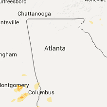
Hail Map for Monday, July 11, 2016

Number of Impacted Households on 7/11/2016
0
Impacted by 1" or Larger Hail
0
Impacted by 1.75" or Larger Hail
0
Impacted by 2.5" or Larger Hail
Square Miles of Populated Area Impacted on 7/11/2016
0
Impacted by 1" or Larger Hail
0
Impacted by 1.75" or Larger Hail
0
Impacted by 2.5" or Larger Hail


Cities Most Affected by Hail Storms of 7/11/2016
| Hail Size | Demographics of Zip Codes Affected | ||||||
|---|---|---|---|---|---|---|---|
| City | Count | Average | Largest | Pop Density | House Value | Income | Age |
| Mora, MN | 2 | 2.13 | 2.50 | 51 | $95k | $37.6k | 42.5 |
Hail and Wind Damage Spotted on 7/11/2016
Filter by Report Type:Hail ReportsWind Reports
States Impacted
Oklahoma, South Carolina, Minnesota, Alabama, North Carolina, Georgia, Louisiana, South Dakota, Mississippi, Wisconsin, Nebraska, Michigan, North Dakota, Iowa, Kansas, MissouriOklahoma
| Local Time | Report Details |
|---|---|
| 9:15 AM CDT | Storm damage reported in woods county OK, 46.7 miles ENE of Woodward, OK |
South Carolina
| Local Time | Report Details |
|---|---|
| 1:28 PM EDT | Trees down reported on turnage roa in chesterfield county SC, 62.9 miles SE of Charlotte, NC |
| 2:42 PM EDT | Trees and power poles down on lake cunningham road. another tree down on north mcelhaney road. another tree down along highway 101 and more trees down near highway 14 t in greenville county SC, 21.4 miles ENE of Greenville, SC |
| 3:25 PM EDT | Storm damage reported in greenville county SC, 24.8 miles E of Greenville, SC |
| 3:25 PM EDT | Several large limbs down along scuffletown road in an area south of five fork in greenville county SC, 22.9 miles E of Greenville, SC |
| 3:58 PM EDT | Trees down between cross anchor and enore in spartanburg county SC, 41.4 miles ESE of Greenville, SC |
| 4:05 PM EDT | Spotter heard over scanner that trees were down from the storm on baton rouge roa in chester county SC, 44.6 miles SW of Charlotte, NC |
| 7:02 PM EDT | Trees and power lines down on lamar hw in darlington county SC, 72.7 miles N of Charleston, SC |
| 7:08 PM EDT | Trees down at darlington ave and south dargan s in darlington county SC, 72.7 miles N of Charleston, SC |
| 7:16 PM EDT | Trees down on n main stree in darlington county SC, 77.8 miles N of Charleston, SC |
| 7:35 PM EDT | Tree in roadway at sandy elm c in dillon county SC, 83.8 miles NNE of Charleston, SC |
| 7:45 PM EDT | Tree down on mccellan ct and jade c in marion county SC, 82.1 miles NNE of Charleston, SC |
| 7:45 PM EDT | Tree down at the intersection of jade ct and carter r in dillon county SC, 83.1 miles NNE of Charleston, SC |
| 7:51 PM EDT | Tree in roadway at the intersection of hwy 917 and burke r in dillon county SC, 79.9 miles W of Wilmington, NC |
| 7:51 PM EDT | Trees dow in pickens county SC, 7.1 miles WNW of Greenville, SC |
Minnesota
| Local Time | Report Details |
|---|---|
| 1:15 PM CDT | Quarter sized hail reported near Sartell, MN, 67.5 miles NW of Minneapolis, MN, hail up to the size of quarters reported 5 miles south of rice. . |
| 2:30 PM CDT | Golf Ball sized hail reported near Mora, MN, 62.2 miles N of Minneapolis, MN, half dollar to golf ball sized hail reported via facebook. . |
| 2:30 PM CDT | Tennis Ball sized hail reported near Mora, MN, 62.2 miles N of Minneapolis, MN, photo of hail shows 2.5 inch diameter stone. reported via twitter. . |
| 3:02 PM CDT | Quarter sized hail reported near Deerwood, MN, 83.3 miles SE of Bemidji, MN, video of quarter sized hail falling. time estimated by radar. |
| 3:17 PM CDT | Trees downed in sandstone which brought power lines down. time estimated by rada in pine county MN, 58.2 miles SW of Duluth, MN |
| 8:39 PM CDT | Quarter sized hail reported near Maple Lake, MN, 39.9 miles WNW of Minneapolis, MN, . |
| 8:50 PM CDT | Quarter sized hail reported near Monticello, MN, 34.3 miles NW of Minneapolis, MN, reported at intersection of hwys 94 and 25. . |
| 9:00 PM CDT | Quarter sized hail reported near Monticello, MN, 34.7 miles NW of Minneapolis, MN, reported on east side of town. . |
| 11:10 PM CDT | 4" diameter tree limb dow in anoka county MN, 28.8 miles N of Minneapolis, MN |
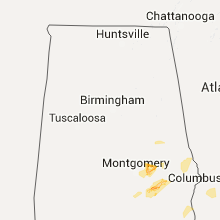
Alabama
| Local Time | Report Details |
|---|---|
| 1:21 PM CDT | Couple of reports of trees down from the cowarts area in houston county AL, 80.5 miles NW of Tallahassee, FL |
| 1:25 PM CDT | A few trees were blown down along county road 97. corrected day to july 11 in henry county AL, 68.5 miles SSE of Auburn, AL |
| 2:08 PM CDT | Trees down across hwy 82 near a church in simsville. winds est at 65mph by rada in bullock county AL, 40 miles SW of Auburn, AL |
| 3:29 PM CDT | Tree down on powerlines in camp hill area near jack wilson road and cr 50. winds est at 45mph per radar in tallapoosa county AL, 16.4 miles NNW of Auburn, AL |
North Carolina
| Local Time | Report Details |
|---|---|
| 2:30 PM EDT | Tree down on peele chapel roa in scotland county NC, 76 miles ESE of Charlotte, NC |
| 2:37 PM EDT | Couple trees down in vicinity of marston road and gum swamp lake roa in scotland county NC, 76.6 miles ESE of Charlotte, NC |
| 3:10 PM EDT | Multiple trees down in the town in maxto in robeson county NC, 82.4 miles SSW of Raleigh, NC |
| 3:50 PM EDT | Tree down on a house at 110 florence ct. severe damage to the house. no injurie in robeson county NC, 66.8 miles WNW of Wilmington, NC |
| 3:56 PM EDT | Multiple trees down in the town of fairmon in robeson county NC, 69.5 miles WNW of Wilmington, NC |
| 4:22 PM EDT | Tree down millie christeen r in columbus county NC, 42.8 miles WNW of Wilmington, NC |
| 4:30 PM EDT | Tree down in evergree in columbus county NC, 55.9 miles WNW of Wilmington, NC |
| 4:40 PM EDT | A few trees dow in burke county NC, 52.9 miles NW of Charlotte, NC |
| 4:47 PM EDT | Quarter sized hail reported near Conover, NC, 43.3 miles NNW of Charlotte, NC, reported on swinging ridge road. |
| 5:10 PM EDT | Power lines down in rosebor in sampson county NC, 58.1 miles S of Raleigh, NC |
| 5:10 PM EDT | Tree down on powerline in salembur in sampson county NC, 53.4 miles S of Raleigh, NC |
| 5:35 PM EDT | Trees down in clinto in sampson county NC, 56.9 miles NNW of Wilmington, NC |
| 5:45 PM EDT | Tree down on the roa in mecklenburg county NC, 6.1 miles ENE of Charlotte, NC |
| 5:50 PM EDT | Quarter sized hail reported near Charlotte, NC, 10.4 miles ENE of Charlotte, NC, report from sam dee road of quarter sized hail. |
| 5:50 PM EDT | Several reports via social media of trees down on the east side of charlott in mecklenburg county NC, 5.8 miles ENE of Charlotte, NC |
| 6:20 PM EDT | Power lines down in northern part of stanly count in stanly county NC, 38 miles ENE of Charlotte, NC |
| 6:40 PM EDT | A couple of trees down south of gold hil in rowan county NC, 33.9 miles NE of Charlotte, NC |
| 7:21 PM EDT | Tree down on hwy 8 near south main street in dento in davidson county NC, 46.3 miles ENE of Charlotte, NC |
Georgia
| Local Time | Report Details |
|---|---|
| 3:05 PM EDT | A tree and a power line were blown down on liberty stree in early county GA, 74.8 miles NNW of Tallahassee, FL |
| 3:06 PM EDT | Tree down on tarver road in early county GA, 76.6 miles NNW of Tallahassee, FL |
| 5:12 PM EDT | 911 call center received report of numerous trees down county-wide in harris county GA, 40.7 miles ENE of Auburn, AL |
| 5:30 PM EDT | 911 call center received reports of multiple trees down. one on hwy 109 and cedar rock rd near woodbury...one on wallace rd near pine mountain...one on east perry st ne in meriwether county GA, 54.1 miles SSW of Atlanta, GA |
| 6:00 PM EDT | Nws employee reported 60 mph wind gusts and some siding taken off of the house from the gusts in fayette county GA, 20.8 miles S of Atlanta, GA |
| 6:00 PM EDT | Nws employee received report of 2 powerlines down on morgan mill rd and 1 large tree and power outage on malone rd in fayette county GA, 26 miles SSW of Atlanta, GA |
| 6:00 PM EDT | Emergency manager received report of blown transformer/wires down on cecil hunter rd near moreland...wall of a building under construction collapse on barnes st in seno in coweta county GA, 38.4 miles SW of Atlanta, GA |
| 6:15 PM EDT | Two trees down near intersection of redwine rd and robinson rd. one tree down in wood creek subdivisio in fayette county GA, 28.4 miles SSW of Atlanta, GA |
| 6:15 PM EDT | Quarter sized hail reported near Woodstock, GA, 25.3 miles NNW of Atlanta, GA, trained spotter reports 1 inch hail near the intersection of hwy 92 and ragsdale rd |
| 6:30 PM EDT | 911 call center received report of one tree down in forest park...one tree down on terrace parkway in morrow...one tree down on mcdonough road near fayetteville/fayette in clayton county GA, 8.9 miles S of Atlanta, GA |
| 6:30 PM EDT | Emergency manager reports a tree down on briarwood trail in cumming...francis circle near milton...westbrook road near chestatee... crooked o trail northeast of chestat in forsyth county GA, 34.9 miles NNE of Atlanta, GA |
| 6:35 PM EDT | Two trees down and some limbs off walt stephens road near the henry county lin in henry county GA, 16.4 miles SSE of Atlanta, GA |
| 6:53 PM EDT | Nws employee received report of 2 powerlines down on morgan mill rd and 1 large tree and power outage on malone rd in fayette county GA, 26 miles SSW of Atlanta, GA |
| 7:00 PM EDT | 911 call center received report of one tree down at hwy 278 and 142e near covington and another tree down at oak hill rd and hwy 212 near west forest in newton county GA, 32.3 miles ESE of Atlanta, GA |
| 7:00 PM EDT | Multiple trees down across walton county...one tree in social circle at alcova dr and laurel ln...trees down on hickory grove church rd near nicholasville...trees down in walton county GA, 39.1 miles E of Atlanta, GA |
| 7:00 PM EDT | 911 call center received report of one tree down on evans mill rd near snapfinger...one tree down on rock springs rd near snapfinger...one tree down on rowland rd near in dekalb county GA, 11.7 miles ESE of Atlanta, GA |
| 7:15 PM EDT | Emergency manager reports power lines down and brush fire on yellow creek rd and one large tree blocking union hill rd in cherokee county GA, 40.8 miles N of Atlanta, GA |
| 8:08 PM EDT | Numerous tress and powerlines down across the area in camden county GA, 29.1 miles N of Jacksonville, FL |
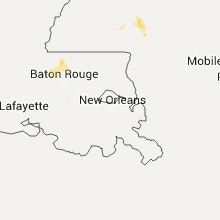
Louisiana
| Local Time | Report Details |
|---|---|
| 3:00 PM CDT | Tree limbs down in burnside in ascension county LA, 54.7 miles WNW of New Orleans, LA |
South Dakota
| Local Time | Report Details |
|---|---|
| 5:28 PM CDT | Storm damage reported in walworth county SD, 81.6 miles N of Pierre, SD |
| 5:35 PM CDT | Storm damage reported in campbell county SD, 78.3 miles SSE of Bismarck, ND |
| 8:59 PM CDT | Storm damage reported in marshall county SD, 55.5 miles ENE of Aberdeen, SD |
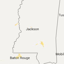
Mississippi
| Local Time | Report Details |
|---|---|
| 6:30 PM CDT | A few trees were down in oak ridg in warren county MS, 33.4 miles WNW of Jackson, MS |
| 6:30 PM CDT | Several trees were down in prentis in jefferson davis county MS, 51.5 miles SSE of Jackson, MS |
| 7:20 PM CDT | Barn destroyed and large tree limbs down at intersection of speed-mcleod and highway 84...reported by em in covington county MS, 58.1 miles SE of Jackson, MS |
| 7:20 PM CDT | Barn destroyed and large tree limbs down at intersection of speed-mcleod and highway 84...reported by em in covington county MS, 58.1 miles SE of Jackson, MS |
| 7:30 PM CDT | Several roads with trees snapped or uprooted including mitchell... troy wade... pickering-rogers... and leaf river church roads...reported by covington county em in covington county MS, 58.2 miles SE of Jackson, MS |
| 7:30 PM CDT | Barn destroyed and large tree limbs down at intersection of speed-mcleod and highway 84...reported by em in covington county MS, 58.1 miles SE of Jackson, MS |
Wisconsin
| Local Time | Report Details |
|---|---|
| 6:44 PM CDT | Several trees down. the largest is 14-18 inches in diameter. time estimated from rada in sawyer county WI, 65.2 miles SSE of Duluth, MN |
| 6:52 PM CDT | The media passed on a report of a tree limb about 6 to 8 inches in diameter dow in bayfield county WI, 58 miles E of Duluth, MN |
| 2:30 AM CDT | Several large trees down and numerous smaller tree limbs broken of in oneida county WI, 16 miles WSW of Rhinelander, WI |
Nebraska
| Local Time | Report Details |
|---|---|
| 7:00 PM CDT | Quarter sized hail reported near Pender, NE, 70.9 miles NW of Omaha, NE |
| 7:10 PM CDT | Storm damage reported in cuming county NE, 68.7 miles NW of Omaha, NE |
| 7:25 PM CDT | Power lines blown dow in cuming county NE, 56.5 miles NW of Omaha, NE |
| 7:30 PM CDT | Trees and power lines blown dow in cuming county NE, 61.1 miles NNW of Omaha, NE |
| 7:33 PM CDT | Also nickel size hai in cuming county NE, 61.1 miles NNW of Omaha, NE |
| 7:43 PM CDT | Storm damage reported in burt county NE, 54.3 miles NNW of Omaha, NE |
| 8:32 PM CDT | Quarter sized hail reported near Superior, NE, 64 miles SSE of Grand Island, NE |
| 8:47 PM CDT | Storm damage reported in burt county NE, 36.6 miles NNW of Omaha, NE |
Michigan
| Local Time | Report Details |
|---|---|
| 7:48 PM CDT | Gogebic county sheriffs office reports large trees in excess of 12" diameter downed across lake rd. near upper powers rd. gogebic county road commission is clearing the in gogebic county MI, 76.8 miles NNW of Rhinelander, WI |
| 11:45 PM CDT | Gogebic county emergency manager reports half a barn was destroyed in bessemer township on elder street. delayed repor in gogebic county MI, 63.1 miles NNW of Rhinelander, WI |
| 11:45 PM CDT | Gogebic county law enforcement reports multiple trees down on a garage with structural damage on spruce street in bessemer township. delayed repor in gogebic county MI, 62.7 miles NNW of Rhinelander, WI |
| 12:00 AM CDT | Gogebic county law enforcement reports multiple trees down in wakefiel in gogebic county MI, 63.4 miles NNW of Rhinelander, WI |
| 12:00 AM CDT | Mesonet station wakefield /mc026 in gogebic county MI, 63.6 miles NNW of Rhinelander, WI |
North Dakota
| Local Time | Report Details |
|---|---|
| 7:55 PM CDT | Peak wind measured at the langdon airport /kd55 in cavalier county ND, 49 miles NNE of Devils Lake, ND |
| 8:55 PM CDT | Peak wind measured at the langdon airport /kd55 in cavalier county ND, 49 miles NNE of Devils Lake, ND |
| 9:15 PM CDT | A few large 3 to 4 inch diameter tree branches broken down...along with some pea sized hai in pembina county ND, 72.7 miles NE of Devils Lake, ND |
Iowa
| Local Time | Report Details |
|---|---|
| 8:25 PM CDT | Storm damage reported in harrison county IA, 39.7 miles N of Omaha, NE |
| 8:32 PM CDT | Storm damage reported in monona county IA, 44.6 miles SW of Storm Lake, IA |
| 8:33 PM CDT | Quarter sized hail reported near Storm Lake, IA, 0.8 miles SE of Storm Lake, IA, social media report. |
| 8:39 PM CDT | Storm damage reported in buena vista county IA, 1.2 miles ESE of Storm Lake, IA |
| 8:50 PM CDT | Several trees and tree limbs down. time estimate in crawford county IA, 49 miles NNE of Omaha, NE |
| 9:11 PM CDT | Numerous tree limbs dow in crawford county IA, 38.3 miles S of Storm Lake, IA |
| 9:20 PM CDT | Storm damage reported in sac county IA, 25.2 miles SSE of Storm Lake, IA |
| 9:23 PM CDT | Half Dollar sized hail reported near Pomeroy, IA, 28.5 miles E of Storm Lake, IA, . |
| 10:03 PM CDT | Public reported large tree limbs downed near intersection of 190th street and baxter avenue west of barnu in webster county IA, 40.8 miles ESE of Storm Lake, IA |
| 10:48 PM CDT | Small tree limbs dow in boone county IA, 35.2 miles NNW of Des Moines, IA |
| 11:00 PM CDT | A few trees and power lines down across ames. a report of a tree on a car on the west side. event time estimated from radar and generally occurred between 1055 pm and 1 in story county IA, 29.7 miles N of Des Moines, IA |
| 11:30 PM CDT | Cattle truck blown ove in mills county IA, 25.2 miles SE of Omaha, NE |
| 12:00 AM CDT | Numerous trees down and uprooted. a large grain bin was pushed several feet onto the railroad tracks. large trash dumpsters tipped ove in bremer county IA, 39.6 miles ESE of Mason City, IA |
Kansas
| Local Time | Report Details |
|---|---|
| 10:50 PM CDT | Ping Pong Ball sized hail reported near Gorham, KS, 17.1 miles E of Hays, KS |
| 11:33 PM CDT | Quarter sized hail reported near Beloit, KS, 78.5 miles WNW of Manhattan, KS, pea to quarter size hail on us-24 from mile marker 226 to 230. |
| 1:15 AM CDT | Quarter sized hail reported near Beloit, KS, 77.6 miles ENE of Hays, KS, hail on-going. has increased from dimes to nickels to quarters. |
| 3:09 AM CDT | Storm damage reported in saline county KS, 64.1 miles WSW of Manhattan, KS |
| 4:13 AM CDT | Out building destroyed and tree down...size unknow in shawnee county KS, 48 miles E of Manhattan, KS |
| 4:18 AM CDT | Tree down...unknown size...at 17th and mission roa in shawnee county KS, 45.7 miles ESE of Manhattan, KS |
| 4:50 AM CDT | Several shingles were blown off of roof at abberdeen apartment in douglas county KS, 41.1 miles WSW of Kansas City, MO |
| 5:10 AM CDT | Tree down near 286th and pratt in atchiso in atchison county KS, 43.5 miles NW of Kansas City, MO |
| 5:36 AM CDT | Several small tree limbs down near 151st street and 69 highwa in johnson county KS, 9.7 miles SSW of Kansas City, MO |
Missouri
| Local Time | Report Details |
|---|---|
| 2:45 AM CDT | Numerous trees down in st. joseph in buchanan county MO, 48.2 miles NNW of Kansas City, MO |
| 3:45 AM CDT | Large tree down across roadway on liberty drive near fairview in clay county MO, 13.4 miles NE of Kansas City, MO |
| 4:39 AM CDT | Tree on a house on south home av in jackson county MO, 6.1 miles E of Kansas City, MO |
| 4:42 AM CDT | Tree down at 39th and chelsea ave in jackson county MO, 4.1 miles SE of Kansas City, MO |
| 5:25 AM CDT | Several trees down in southern parkvill in platte county MO, 8.5 miles NW of Kansas City, MO |
| 6:20 AM CDT | Trees down at 6th and clark as well as 1st and virginia in bates county MO, 50.1 miles SSE of Kansas City, MO |
Connect with Interactive Hail Maps