

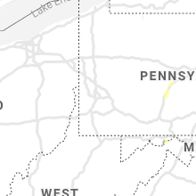
Hail Map for Sunday, July 11, 2021

Number of Impacted Households on 7/11/2021
0
Impacted by 1" or Larger Hail
0
Impacted by 1.75" or Larger Hail
0
Impacted by 2.5" or Larger Hail
Square Miles of Populated Area Impacted on 7/11/2021
0
Impacted by 1" or Larger Hail
0
Impacted by 1.75" or Larger Hail
0
Impacted by 2.5" or Larger Hail


Cities Most Affected by Hail Storms of 7/11/2021
| Hail Size | Demographics of Zip Codes Affected | ||||||
|---|---|---|---|---|---|---|---|
| City | Count | Average | Largest | Pop Density | House Value | Income | Age |
| Alamogordo, NM | 2 | 1.75 | 1.75 | 86 | $78k | $31.6k | 39.2 |
| Picacho, NM | 1 | 2.00 | 2.00 | 0 | $85k | $34.2k | 27.7 |
| Cloudcroft, NM | 1 | 1.75 | 1.75 | 6 | $109k | $38.3k | 53.8 |
| Roswell, NM | 1 | 1.75 | 1.75 | 21 | $0k | $0.0k | 31.0 |
| Cimarron, NM | 1 | 1.70 | 1.70 | 1 | $80k | $30.0k | 46.9 |
Hail and Wind Damage Spotted on 7/11/2021
Filter by Report Type:Hail ReportsWind Reports
States Impacted
North Carolina, New Mexico, Texas, Kentucky, Pennsylvania, Montana, Florida, Alabama, South Carolina, Arizona, Maryland, Nevada, West Virginia, TennesseeNorth Carolina
| Local Time | Report Details |
|---|---|
| 1:33 PM EDT | *** 3 inj *** corrects previous storm report. a tree fell onto a trailer at 1034 moms farm trail in yadkinville... nc. 3 minor injuries reported by the emergency manage in yadkin county NC, 62.2 miles NNE of Charlotte, NC |
New Mexico
| Local Time | Report Details |
|---|---|
| 12:01 PM MDT | Half Dollar sized hail reported near Tatum, NM, 70.2 miles E of Roswell, NM, tatum police report hail slightly larger than quarters. |
| 2:18 PM MDT | Golf Ball sized hail reported near Roswell, NM, 1.8 miles SSW of Roswell, NM |
| 2:43 PM MDT | Quarter sized hail reported near Roswell, NM, 3.8 miles S of Roswell, NM, brasher and main |
| 2:47 PM MDT | Quarter sized hail reported near Roswell, NM, 1.8 miles SSW of Roswell, NM |
| 2:56 PM MDT | Storm damage reported in chaves county NM, 22.6 miles SSE of Roswell, NM |
| 3:22 PM MDT | Quarter sized hail reported near Milnesand, NM, 75.8 miles ENE of Roswell, NM |
| 3:32 PM MDT | Hen Egg sized hail reported near Picacho, NM, 35.8 miles W of Roswell, NM, from an online picture with a ruler from bar guitar ranch |
| 3:42 PM MDT | Quarter sized hail reported near Cuba, NM, 66.7 miles NNW of Albuquerque, NM |
| 3:50 PM MDT | Quarter sized hail reported near Cuba, NM, 66.7 miles NNW of Albuquerque, NM |
| 4:55 PM MDT | Golf Ball sized hail reported near Cloudcroft, NM, 77.8 miles WSW of Roswell, NM |
| 5:00 PM MDT | Quarter sized hail reported near Carrizozo, NM, 83.7 miles WNW of Roswell, NM, valley of fires park |
| 5:16 PM MDT | Quarter sized hail reported near Santa Fe, NM, 55.1 miles SSW of Taos, NM, agua fria and st francis |
| 5:17 PM MDT | Quarter sized hail reported near Santa Fe, NM, 55.1 miles SSW of Taos, NM |
| 5:35 PM MDT | Quarter sized hail reported near Alamogordo, NM, 80.2 miles NNE of El Paso, TX, hard rain and strong winds also. |
| 5:39 PM MDT | Golf Ball sized hail reported near Alamogordo, NM, 79.5 miles NNE of El Paso, TX, hail covering ground. |
| 5:41 PM MDT | Golf Ball sized hail reported near Alamogordo, NM, 76.3 miles NNE of El Paso, TX, location estimated. |
| 5:54 PM MDT | Quarter sized hail reported near Carrizozo, NM, 80.1 miles WNW of Roswell, NM |
| 6:00 PM MDT | Wsm47 from wsmr sams networ in otero county NM, 91.8 miles NNE of El Paso, TX |
| 6:00 PM MDT | Mesonet station wsm22 wsmr salt cree in sierra county NM, 94.1 miles N of El Paso, TX |
| 6:15 PM MDT | Mesonet station wsm31 wsmr rad 2m towe in dona ana county NM, 71.7 miles N of El Paso, TX |
| 6:50 PM MDT | Mesonet station wsm50 lc-35 nort in otero county NM, 47.7 miles N of El Paso, TX |
| 6:50 PM MDT | Mesonet station wsm05 san agustin pass 1.6 e organ (wsmr in dona ana county NM, 46.5 miles N of El Paso, TX |
| 7:15 PM MDT | Mesonet station ew1486 twin peaks wind speeds on ridge to in dona ana county NM, 47 miles NNW of El Paso, TX |
| 7:15 PM MDT | Marble sized hail along with torrential rain. 1.65 inches measured in 10-15 minute in dona ana county NM, 41.9 miles N of El Paso, TX |
| 7:20 PM MDT | Mesonet station fw6984 las cruce in dona ana county NM, 43.6 miles NNW of El Paso, TX |
| 7:24 PM MDT | Quarter sized hail reported near Roy, NM, 68.8 miles NNW of Tucumcari, NM |
| 7:26 PM MDT | Mesonet station lomn5 dripping springs raw in dona ana county NM, 39.1 miles N of El Paso, TX |
| 7:26 PM MDT | Mesonet station fw6984 las cruce in dona ana county NM, 43.6 miles NNW of El Paso, TX |
| 7:30 PM MDT | Large trees blown across new mexico state campu in dona ana county NM, 39.1 miles NNW of El Paso, TX |
| 7:30 PM MDT | Report from mping: trees uprooted or snapped; roof blown off time estimate in dona ana county NM, 41.4 miles NNW of El Paso, TX |
| 10:15 PM MDT | Corrects previous tstm wnd gst report from 5 ene road forks. mesonet station nm008 lordsburg playa i10 mp7 (nmdot). multi-vehicle accident involving cmvs on i-10 from h in hidalgo county NM, 52.4 miles SW of Silver City, NM |
| 10:20 PM MDT | Mesonet station acdm chiricahua desert museu in hidalgo county NM, 47.9 miles NE of Douglas, AZ |
| 10:23 PM MDT | Ping Pong Ball sized hail reported near Cimarron, NM, 34.9 miles E of Taos, NM, hail lasted 15 minutes |
Texas
| Local Time | Report Details |
|---|---|
| 2:25 PM CDT | Storm damage reported in cochran county TX, 45.7 miles WSW of Lubbock, TX |
| 8:04 PM CDT | Quarter sized hail reported near Gardendale, TX, 11.8 miles N of Odessa, TX, pea to quarter size hail. |
| 8:10 PM MDT | Downed tree covering road. time estimate in el paso county TX, 9.1 miles NW of El Paso, TX |
| 8:35 PM MDT | Half Dollar sized hail reported near El Paso, TX, 6.1 miles NNW of El Paso, TX, several reports of hail across west el paso of up to 1.25 inches. sources are trained spotters... nws employees... and public. |
Kentucky
| Local Time | Report Details |
|---|---|
| 2:34 PM CDT | Tree down at mansfield road and oil well road. time estimated by rada in barren county KY, 68.7 miles NE of Nashville, TN |
Pennsylvania
| Local Time | Report Details |
|---|---|
| 4:33 PM EDT | Trees down on wires in westmoreland county PA, 25.7 miles ESE of Pittsburgh, PA |
| 5:14 PM EDT | Trees down in the 400 block of pleasant valley blv in blair county PA, 33.6 miles SW of State College, PA |
| 5:15 PM EDT | Several reports of trees and wires down across the east end of altoon in blair county PA, 32.8 miles SW of State College, PA |
| 5:32 PM EDT | Trees and wires dow in blair county PA, 28 miles WSW of State College, PA |
| 5:43 PM EDT | Tree on wires in benezette townshi in elk county PA, 45.4 miles NW of State College, PA |
| 5:45 PM EDT | Numerous reports of trees and wires down across northern somerset county in the vicnity of jennerstown... boswell and jerom in somerset county PA, 54.9 miles ESE of Pittsburgh, PA |
| 6:13 PM EDT | Roof damage to a building in the 1800 block of union av in blair county PA, 34.9 miles SW of State College, PA |
| 6:20 PM EDT | Sporadic reports of trees down across northern bedford count in bedford county PA, 58.2 miles SW of State College, PA |
| 6:24 PM EDT | Wires down near the intersection of tamarack road and kettle creek road in leidy townshi in clinton county PA, 44.6 miles N of State College, PA |
| 6:27 PM EDT | Trees and wires dow in blair county PA, 21.4 miles WSW of State College, PA |
| 6:38 PM EDT | Trees and wires dow in blair county PA, 18 miles WSW of State College, PA |
| 6:52 PM EDT | Multiple reports of trees down in lincoln township near the lake raystown resor in huntingdon county PA, 37.4 miles SSW of State College, PA |
| 6:57 PM EDT | Tree down across road near the intersection of south nixon road and pine grove road in ferguson townshi in centre county PA, 4.7 miles SSW of State College, PA |
| 7:02 PM EDT | Tree down on wires in the 400 block of ridge avenu in centre county PA, 1.1 miles WNW of State College, PA |
| 7:15 PM EDT | Tree on wires in the 500 block of maple grove road... closing the roa in mifflin county PA, 14.4 miles SSE of State College, PA |
| 7:32 PM EDT | Trees down... some on vehicles. six campsites damaged. no injurie in centre county PA, 20.6 miles E of State College, PA |
| 7:35 PM EDT | Trees and wires dow in mifflin county PA, 20.6 miles ESE of State College, PA |
| 7:38 PM EDT | Several reports of trees and wires down between lock haven and avi in clinton county PA, 36.4 miles NE of State College, PA |
| 7:38 PM EDT | Trees down near the intersection of broad road and pine creek road east of cobur in centre county PA, 22.8 miles ENE of State College, PA |
| 7:59 PM EDT | Multiple reports of trees down in and around avi in clinton county PA, 39.3 miles NE of State College, PA |
| 8:19 PM EDT | Multiple reports of wires down along park road between shirley drive and bluebird lan in union county PA, 53.4 miles E of State College, PA |
| 8:37 PM EDT | Wires down along upper bailey road in miller townshi in perry county PA, 46.3 miles ESE of State College, PA |
| 8:49 PM EDT | Trees down... some on vehicle in perry county PA, 52.5 miles ESE of State College, PA |
| 9:03 PM EDT | Trees and wires dow in columbia county PA, 50.4 miles SW of Scranton, PA |
| 9:03 PM EDT | Trees and wires dow in columbia county PA, 52.4 miles SW of Scranton, PA |
| 9:04 PM EDT | Tree down blocking road. radar estimated tim in wyoming county PA, 22.4 miles NW of Scranton, PA |
| 9:25 PM EDT | Tree down blocking road. radar estimated tim in wyoming county PA, 11.1 miles WNW of Scranton, PA |
| 9:27 PM EDT | Trees down in eldred townshi in schuylkill county PA, 67.5 miles SW of Scranton, PA |
| 9:30 PM EDT | Some trees and wires down with power outages. radar estimated tim in luzerne county PA, 37.4 miles SW of Scranton, PA |
| 9:31 PM EDT | Storm damage reported in cumberland county PA, 63.4 miles SE of State College, PA |
| 9:31 PM EDT | Tree down on spanglers mill road between lisburn road and the mil in cumberland county PA, 64.3 miles SE of State College, PA |
| 10:20 PM EDT | Reports of trees down in the tamaqua are in schuylkill county PA, 45.1 miles SSW of Scranton, PA |
Montana
| Local Time | Report Details |
|---|---|
| 2:35 PM MDT | Quarter sized hail reported near , , 80.1 miles ENE of Whitefish, MT, 1 inch hail estimated just west of del bonita. |
| 3:23 PM MDT | Asos station kctb cut bank airport. sustained wind 41mph at time of gus in glacier county MT, 90.2 miles NNW of Great Falls, MT |
| 3:24 PM MDT | Power lines down in cut bank with a high number of power outages. also reported a tree was downe in glacier county MT, 91.5 miles NNW of Great Falls, MT |
| 3:29 PM MDT | Asos station kctb cut bank airpor in glacier county MT, 90.2 miles NNW of Great Falls, MT |
| 4:00 PM MDT | Measured at toole county airport... via ambient weathe in toole county MT, 76 miles NNW of Great Falls, MT |
| 4:30 PM MDT | Swing set blown away... many trees had significant number of limbs blown of in liberty county MT, 63.9 miles N of Great Falls, MT |
| 4:34 PM MDT | Storm damage reported in toole county MT, 74.4 miles W of Havre, MT |
| 4:58 PM MDT | Via ambient weather mesone in hill county MT, 46.1 miles WSW of Havre, MT |
| 4:59 PM MDT | Storm damage reported in liberty county MT, 52.7 miles WNW of Havre, MT |
| 5:00 PM MDT | Via ambient weather mesone in hill county MT, 41.5 miles WSW of Havre, MT |
| 5:05 PM MDT | Storm damage reported in hill county MT, 44.9 miles W of Havre, MT |
| 5:14 PM MDT | Via ambient weather mesone in chouteau county MT, 42.3 miles SW of Havre, MT |
| 5:20 PM MDT | Storm damage reported in chouteau county MT, 48.5 miles NE of Great Falls, MT |
| 5:24 PM MDT | Powerlines down on us 87 near veron in chouteau county MT, 38.3 miles SW of Havre, MT |
| 5:30 PM MDT | Semi blown of highway 87... near mile marker 78. power lines blown down in the area. unknown number of injuries. report via mt highway patrol. time of event is estimate in chouteau county MT, 33.9 miles SW of Havre, MT |
| 5:41 PM MDT | Measured at khv in hill county MT, 4.6 miles W of Havre, MT |
| 5:45 PM MDT | Storm damage reported in chouteau county MT, 53.2 miles ENE of Great Falls, MT |
| 6:00 PM MDT | Measured by site mtm0 in hill county MT, 7.3 miles SW of Havre, MT |
| 9:50 PM MDT | Time estimated from radar. mesonet station popm8 poplar raw in roosevelt county MT, 67 miles W of Williston, ND |
Florida
| Local Time | Report Details |
|---|---|
| 4:37 PM EDT | A structure attached to a manufactured home was blow over by a straight-line wind (downburst in manatee county FL, 6.8 miles NNE of Bradenton, FL |
Alabama
| Local Time | Report Details |
|---|---|
| 3:39 PM CDT | Large tree down on a power line near the corner of burwell road and carters gin road. time estimated from rada in madison county AL, 57.8 miles E of Florence, AL |
| 3:55 PM CDT | Tree down on a trailer off johnson road. time estimated from rada in madison county AL, 61.7 miles E of Florence, AL |
| 3:57 PM CDT | Tree down near mountain park circle and kirkland dr. time estimated from rada in madison county AL, 61.2 miles E of Florence, AL |
| 4:00 PM CDT | Tree down at the corner of stevens drive and stevens court. time estimated from rada in madison county AL, 63.5 miles E of Florence, AL |
| 4:03 PM CDT | 6 to 8 inch tree limbs down in the five points area of huntsvill in madison county AL, 62.4 miles E of Florence, AL |
| 4:20 PM CDT | Tree down on bluff city road north of somerville. time estimated from rada in morgan county AL, 54.5 miles ESE of Florence, AL |
| 5:02 PM CDT | Tree down on a house on 6th street. time estimated from rada in marshall county AL, 58.1 miles NNE of Birmingham, AL |
| 5:02 PM CDT | Tree down on a house on friendship road. time estimated from rada in marshall county AL, 62.1 miles NNE of Birmingham, AL |
| 5:02 PM CDT | Tree down across tower drive near lowery drive. time estimated from rada in marshall county AL, 60.6 miles NNE of Birmingham, AL |
| 5:30 PM CDT | A large pine tree was downed onto a residence. there were no injuries. time estimated from rada in jefferson county AL, 19.4 miles NNE of Birmingham, AL |
| 5:34 PM CDT | Tree down in the roadway near the intersection of blueberry ln. and baker mountain rd. time estimated from rada in marshall county AL, 63.2 miles SW of Chattanooga, TN |
| 5:54 PM CDT | Single tree down reports at various locations in leesburg. one tree fell onto a garage and pontoon boat. time estimated from rada in cherokee county AL, 65 miles SSW of Chattanooga, TN |
| 6:06 PM CDT | Tree down on county road 33 approximately halfway up crow mountain. time estimated from rada in jackson county AL, 44 miles WSW of Chattanooga, TN |
| 6:16 PM CDT | Tree down near the corner of bethsaida rd and strawn rd. time estimated from rada in marshall county AL, 61.1 miles NE of Birmingham, AL |
South Carolina
| Local Time | Report Details |
|---|---|
| 5:52 PM EDT | Broadcast media reported large tree branches down on powerlines on wells av in greenwood county SC, 49.5 miles NNW of Augusta, GA |
Arizona
| Local Time | Report Details |
|---|---|
| 3:48 PM MST | Quarter sized hail reported near Dewey, AZ, 59.2 miles SW of Flagstaff, AZ |
| 3:49 PM MST | Quarter sized hail reported near Prescott, AZ, 59.6 miles SW of Flagstaff, AZ |
| 3:52 PM MST | Half Dollar sized hail reported near Prescott, AZ, 60.5 miles SW of Flagstaff, AZ |
| 3:55 PM MST | Half Dollar sized hail reported near Prescott, AZ, 61.7 miles SW of Flagstaff, AZ, half dollar size hail measured by spotter y421. |
| 3:59 PM MST | Quarter sized hail reported near Prescott, AZ, 61.7 miles SW of Flagstaff, AZ |
| 4:04 PM MST | Half Dollar sized hail reported near Prescott, AZ, 60.8 miles SW of Flagstaff, AZ, trained spotter y532 reports hail up to 1.25 inches in diameter. |
| 4:14 PM MST | Asos station kprc prescott airpor in yavapai county AZ, 57.7 miles SW of Flagstaff, AZ |
| 4:16 PM MST | Quarter sized hail reported near Prescott Valley, AZ, 57.7 miles SW of Flagstaff, AZ, trained spotter reported hail estimated around a quarter in size. |
| 4:16 PM MST | Wind gusts from a passing severe thunderstorm estimated around 60 mp in yavapai county AZ, 57.7 miles SW of Flagstaff, AZ |
| 4:30 PM MST | Law enforcement dispatch reported damage to the roof of an apartment complex in prescot in yavapai county AZ, 64.5 miles SW of Flagstaff, AZ |
| 4:30 PM MST | Four power poles in prescott valley were snapped and reported to the prescott police dispatc in yavapai county AZ, 56.8 miles SW of Flagstaff, AZ |
Maryland
| Local Time | Report Details |
|---|---|
| 8:15 PM EDT | Numerous trees down along orleans road in allegany county MD, 85 miles SSW of State College, PA |
| 8:40 PM EDT | Tree down on us 522 at high street in washington county MD, 77.4 miles SSW of State College, PA |
| 8:40 PM EDT | Wires down on baptist roa in washington county MD, 77.3 miles SSW of State College, PA |
Nevada
| Local Time | Report Details |
|---|---|
| 5:15 PM PDT | High winds lasted for approximately 15 minute in nye county NV, 113.5 miles NW of Las Vegas, NV |
| 7:50 PM PDT | Storm damage reported in lincoln county NV, 62.9 miles W of Saint George, UT |
| 12:15 AM PDT | Awos station kbvu boulder city airport gusted to 66 mph. likely heat burst as weak convection moved through with an associated temp increase from 86 to 97 at observatio in clark county NV, 21.5 miles SE of Las Vegas, NV |
West Virginia
| Local Time | Report Details |
|---|---|
| 8:40 PM EDT | Tree down on us 522 at river road in morgan county WV, 78.1 miles SSW of State College, PA |
Tennessee
| Local Time | Report Details |
|---|---|
| 8:50 PM EDT | Power outages reported in oak ridge by local media associated with a thunderstorm. wind gust of 30 mph observed at koqt. time estimate in anderson county TN, 18.9 miles WNW of Knoxville, TN |
Connect with Interactive Hail Maps