

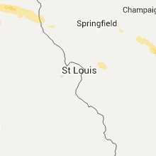
Hail Map for Monday, July 13, 2015

Number of Impacted Households on 7/13/2015
0
Impacted by 1" or Larger Hail
0
Impacted by 1.75" or Larger Hail
0
Impacted by 2.5" or Larger Hail
Square Miles of Populated Area Impacted on 7/13/2015
0
Impacted by 1" or Larger Hail
0
Impacted by 1.75" or Larger Hail
0
Impacted by 2.5" or Larger Hail


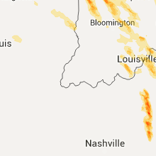


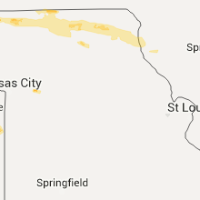


Cities Most Affected by Hail Storms of 7/13/2015
| Hail Size | Demographics of Zip Codes Affected | ||||||
|---|---|---|---|---|---|---|---|
| City | Count | Average | Largest | Pop Density | House Value | Income | Age |
| Marseilles, IL | 3 | 3.17 | 3.75 | 95 | $92k | $44.5k | 41.1 |
| Calamus, IA | 4 | 2.06 | 2.75 | 16 | $75k | $43.9k | 42.9 |
| Hutchinson, KS | 3 | 2.67 | 2.75 | 297 | $94k | $45.1k | 46.4 |
| East Chicago, IN | 3 | 2.08 | 2.75 | 1855 | $70k | $26.5k | 30.9 |
| Turon, KS | 3 | 1.75 | 1.75 | 3 | $31k | $28.1k | 44.3 |
| Cimarron, KS | 1 | 2.75 | 2.75 | 2 | $80k | $40.2k | 34.1 |
| Larned, KS | 1 | 2.75 | 2.75 | 16 | $52k | $34.2k | 42.2 |
| Osseo, WI | 1 | 2.50 | 2.50 | 27 | $78k | $40.1k | 40.6 |
| Chicago, IL | 1 | 2.50 | 2.50 | 1207 | $93k | $40.8k | 37.7 |
| Grand Mound, IA | 1 | 2.00 | 2.00 | 16 | $77k | $46.1k | 42.0 |
| Pickering, MO | 1 | 1.75 | 1.75 | 10 | $35k | $40.7k | 40.4 |
| Le Claire, IA | 1 | 1.75 | 1.75 | 194 | $105k | $50.3k | 41.9 |
| Taylor, WI | 1 | 1.75 | 1.75 | 19 | $56k | $34.5k | 37.2 |
| Herscher, IL | 1 | 1.75 | 1.75 | 28 | $114k | $50.0k | 38.6 |
| Greensburg, KY | 1 | 1.75 | 1.75 | 47 | $53k | $24.2k | 42.9 |
| Calumet City, IL | 1 | 1.75 | 1.75 | 5114 | $90k | $38.8k | 35.1 |
| Capron, IL | 1 | 1.75 | 1.75 | 53 | $112k | $51.9k | 36.6 |
| Gary, IN | 1 | 1.75 | 1.75 | 1691 | $41k | $18.8k | 34.7 |
| Carbondale, KS | 1 | 1.75 | 1.75 | 39 | $69k | $37.3k | 42.8 |
| Columbia, KY | 1 | 1.75 | 1.75 | 48 | $62k | $24.4k | 38.5 |
| Ottawa, IL | 1 | 1.75 | 1.75 | 161 | $92k | $39.2k | 41.7 |
| Naperville, IL | 1 | 1.75 | 1.75 | 3226 | $243k | $87.5k | 39.2 |
| Abbyville, KS | 1 | 1.75 | 1.75 | 4 | $34k | $41.0k | 50.7 |
| Wellington, MO | 1 | 1.75 | 1.75 | 16 | $68k | $39.4k | 42.3 |
Hail and Wind Damage Spotted on 7/13/2015
Filter by Report Type:Hail ReportsWind Reports
States Impacted
Minnesota, Michigan, Illinois, Indiana, Ohio, Georgia, North Carolina, Kentucky, Wisconsin, New York, Florida, Alabama, Missouri, West Virginia, South Carolina, Kansas, Virginia, Iowa, TennesseeMinnesota
| Local Time | Report Details |
|---|---|
| 7:05 AM CDT | Large trees split open on north side of tow in douglas county MN, 70.6 miles N of Montevideo, MN |
| 7:15 AM CDT | Large trees split open. occurred sporadically from 3 to 4 miles se of town along county road 8 in douglas county MN, 68 miles N of Montevideo, MN |
Michigan
| Local Time | Report Details |
|---|---|
| 8:32 AM EDT | Shingles off of the roof of a building and a large tree uproote in berrien county MI, 59.1 miles E of Chicago, IL |
| 8:35 AM EDT | 1 tree dow in van buren county MI, 58.1 miles SSW of Grand Rapids, MI |
| 8:40 AM EDT | Delayed report. 1.5 ft diameter tree downed on a house. health of tree unknown. time estimated by rada in berrien county MI, 66.8 miles E of Chicago, IL |
| 9:05 AM EDT | Wind gust estimated 45 mph in st. joseph county MI, 65.7 miles NNW of Fort Wayne, IN |
| 9:12 AM EDT | A tree was down near mottville blocking highway 12 in st. joseph county MI, 60.6 miles NW of Fort Wayne, IN |
| 9:13 AM EDT | Tree down in st. joseph county MI, 59.5 miles NNW of Fort Wayne, IN |
| 9:15 AM EDT | Small branches down - reports of trees down 2 in berrien county MI, 65.8 miles E of Chicago, IL |
| 9:16 AM EDT | At the fairgrounds. some tree branches and flags dow in st. joseph county MI, 62.2 miles NNW of Fort Wayne, IN |
| 9:18 AM EDT | Tree down on youngs prairie road. time estimated from rada in st. joseph county MI, 63.9 miles NNW of Fort Wayne, IN |
| 9:20 AM EDT | A tree down in st. joseph county MI, 53.1 miles NNW of Fort Wayne, IN |
| 9:20 AM EDT | Delayed report. trees and power line down. time estimated by rada in st. joseph county MI, 57.3 miles NNW of Fort Wayne, IN |
| 9:25 AM EDT | Large tree down m-86 and nottawa r in st. joseph county MI, 61.1 miles NNW of Fort Wayne, IN |
| 9:35 AM EDT | Large tree down m-86 and nottawa r in st. joseph county MI, 61.1 miles NNW of Fort Wayne, IN |
| 12:20 AM EDT | A few trees were reported down around warner and 92nd... as well as 92nd and 64th st. south of fremont. report relayed via ham radio operato in newaygo county MI, 32.2 miles NNW of Grand Rapids, MI |
| 12:20 AM EDT | Tree reported down on a car with people inside. relayed by ham radio operato in newaygo county MI, 42.4 miles N of Grand Rapids, MI |
| 12:38 AM EDT | Estimated wind gusts between 50 and 60 mph. some small tree debris was noted by the spotter at the time of the repor in allegan county MI, 28.9 miles SW of Grand Rapids, MI |
| 12:41 AM EDT | Spotter estimated 50 mph winds in the area and noted that fire dept reported power lines down in the area of columbia and 38th in ottawa county MI, 23.7 miles WSW of Grand Rapids, MI |
| 12:57 AM EDT | Tree limb down blocking east bound roadway reported by central dispatch and relayed by e in calhoun county MI, 60.8 miles SSE of Grand Rapids, MI |
| 12:59 AM EDT | Central dispatch reported that a tree was blocking ottawa beach rd in park twp in ottawa county MI, 28.1 miles WSW of Grand Rapids, MI |
| 1:00 AM EDT | Barn reported down with cattle kille in isabella county MI, 64.3 miles NNE of Grand Rapids, MI |
| 1:05 AM EDT | Mesonet station dorr /e7465/ in allegan county MI, 16.4 miles S of Grand Rapids, MI |
| 1:08 AM EDT | Central dispatch reported a tree down at 11 mile and round lake in mecosta county MI, 49.5 miles NNE of Grand Rapids, MI |
| 1:08 AM EDT | Online submission of roof damage to home along with several tree limbs that were downed in the are in kent county MI, 13.2 miles E of Grand Rapids, MI |
| 1:15 AM EDT | Tree down at 6th street and college av in ottawa county MI, 24.9 miles WSW of Grand Rapids, MI |
| 1:16 AM EDT | Wood-tv relayed a report of tree down near maplebrook rd in caledonia. they also received reports of shingles taken of a house... as well as a window blown ou in kent county MI, 8.1 miles S of Grand Rapids, MI |
| 1:22 AM EDT | Power line reported down at 56th and division. relayed by wood-tv in kent county MI, 7.4 miles S of Grand Rapids, MI |
| 1:46 AM EDT | Trees reported down at appletree and m-66 in ionia county MI, 30.1 miles E of Grand Rapids, MI |
| 1:56 AM EDT | Trees and power lines reported down at the 200 block of west riverside drive in ionia county MI, 30.5 miles E of Grand Rapids, MI |
| 2:16 AM EDT | Tree limb down on south warren rd in shiawassee county MI, 33.2 miles W of Flint, MI |
| 2:32 AM EDT | Tree limb down at lennon and vernon rd in venice twp in shiawassee county MI, 17.6 miles W of Flint, MI |
| 2:50 AM EDT | Measured at saginaw bay light 1 /sblm4/ in lhz422 county MI, 55.2 miles N of Flint, MI |
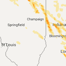
Illinois
| Local Time | Report Details |
|---|---|
| 8:50 AM CDT | Quarter sized hail reported near Kewanee, IL, 41.8 miles NNW of Peoria, IL, relayed by wqad and kwqc twitter feeds. |
| 9:15 AM CDT | Quarter sized hail reported near Wyoming, IL, 28.5 miles N of Peoria, IL |
| 9:20 AM CDT | Large tree limbs down and a shed damaged by wind in vermilion county IL, 77.8 miles NNE of Mattoon, IL |
| 9:45 AM CDT | Tree and power lines down 2650 n in vermilion county IL, 65.8 miles NE of Mattoon, IL |
| 9:49 AM CDT | Tree down across railroad tracks at 3rd street in vermilion county IL, 60.7 miles NE of Mattoon, IL |
| 10:20 AM CDT | Tree and power lines down on douglas s in vermilion county IL, 53.9 miles NE of Mattoon, IL |
| 5:40 PM CDT | Golf Ball sized hail reported near Ottawa, IL, 59.9 miles NE of Peoria, IL, north of route 6. |
| 5:49 PM CDT | Quarter sized hail reported near Marseilles, IL, 64.3 miles NE of Peoria, IL, penny to quarter size. near 2653 and 2350 road. social media. |
| 5:50 PM CDT | Tea Cup sized hail reported near Marseilles, IL, 64.3 miles NE of Peoria, IL, 500 sycamore st. hail 3.75 inches via social media picture. |
| 5:50 PM CDT | Tea Cup sized hail reported near Marseilles, IL, 64.3 miles NE of Peoria, IL, 500 sycamore st. hail 3.75 inches via social media picture. |
| 5:52 PM CDT | Baseball sized hail reported near Marseilles, IL, 64.3 miles NE of Peoria, IL |
| 6:03 PM CDT | Half Dollar sized hail reported near Geneseo, IL, 60 miles NNW of Peoria, IL |
| 6:03 PM CDT | Ping Pong Ball sized hail reported near Geneseo, IL, 60 miles NNW of Peoria, IL, quarter to ping pong ball sized hail |
| 6:14 PM CDT | Rotation in clouds sighte in adams county IL, 38.1 miles SSE of Kahoka, MO |
| 6:21 PM CDT | Large limbs downe in adams county IL, 38.1 miles SSE of Kahoka, MO |
| 6:22 PM CDT | 67 mph wind gust at uin in adams county IL, 37 miles SSE of Kahoka, MO |
| 6:22 PM CDT | Multiple reports of trees and power lines down in quinc in adams county IL, 38.1 miles SSE of Kahoka, MO |
| 6:22 PM CDT | Peak wind gust measured at the kuin asos in adams county IL, 43.1 miles SE of Kahoka, MO |
| 6:25 PM CDT | Storm damage reported in adams county IL, 43.1 miles SE of Kahoka, MO |
| 6:25 PM CDT | Trees uprooted in adams county IL, 48.6 miles SSE of Kahoka, MO |
| 6:26 PM CDT | The town is near quincy illinoi in adams county IL, 40 miles SE of Kahoka, MO |
| 6:30 PM CDT | 1-2 foot diameter trees blown down at the roots in adams county IL, 52.7 miles SSE of Kahoka, MO |
| 6:36 PM CDT | Wind blew antenna down in adams county IL, 49.3 miles SE of Kahoka, MO |
| 6:39 PM CDT | Trees down. siding ripped off hous in pike county IL, 61.4 miles SE of Kahoka, MO |
| 6:40 PM CDT | Sixty foot tall tree downe in adams county IL, 48.6 miles SSE of Kahoka, MO |
| 6:45 PM CDT | Large teee down on highway 10 in brown county IL, 61.8 miles SE of Kahoka, MO |
| 6:47 PM CDT | Tree and vehicle damage reporte in adams county IL, 52.7 miles SSE of Kahoka, MO |
| 6:50 PM CDT | Large tree uprooted in pike county IL, 71.8 miles SE of Kahoka, MO |
| 6:51 PM CDT | Numerous tree limbs downe in pike county IL, 61.4 miles SE of Kahoka, MO |
| 6:55 PM CDT | Storm damage reported in pike county IL, 73.9 miles SE of Kahoka, MO |
| 6:55 PM CDT | Several large tree limbs dow in brown county IL, 67.4 miles ESE of Kahoka, MO |
| 7:04 PM CDT | Power outages in chapin in morgan county IL, 76.8 miles SW of Peoria, IL |
| 7:10 PM CDT | Trees and powerlines blown down 3 miles southwest of wincheste in scott county IL, 69 miles NNW of Saint Louis, MO |
| 7:18 PM CDT | Estimated 60 plus mph wind gusts blew large tree limbs down...as well as shingles blown across the road on south westgate av in morgan county IL, 75.1 miles SSW of Peoria, IL |
| 7:18 PM CDT | Power poles blown down with estimated 60-70 mph wind gust on the south side of jacksonville in morgan county IL, 75.2 miles SSW of Peoria, IL |
| 7:18 PM CDT | Power poles blown down with estimated 60 to 70 mph winds on the south side of jacksonvill in morgan county IL, 75.2 miles SSW of Peoria, IL |
| 7:18 PM CDT | Estimated 60 plus mph wind gusts blew large tree limbs down...as well as shingles blown across the road on south westgate av in morgan county IL, 75.1 miles SSW of Peoria, IL |
| 7:20 PM CDT | Golf Ball sized hail reported near Herscher, IL, 62.5 miles SSW of Chicago, IL, half dollar to golfball size hail. |
| 7:20 PM CDT | Two to four inch diameter tree limbs blown down in murrayvill in morgan county IL, 65.7 miles N of Saint Louis, MO |
| 7:30 PM CDT | 6 foot diameter tree blown down in macoupin county IL, 60 miles N of Saint Louis, MO |
| 7:30 PM CDT | Tree split landing on house...large tree was blown down on garag in sangamon county IL, 70 miles NNE of Saint Louis, MO |
| 7:35 PM CDT | Power lines down blocking highway 111. some trees down across town as wel in macoupin county IL, 56.4 miles N of Saint Louis, MO |
| 7:39 PM CDT | Tennis Ball sized hail reported near Chicago, IL, 15.9 miles SSE of Chicago, IL, minor roof and tree damage. broken house windows. |
| 7:40 PM CDT | Half Dollar sized hail reported near Calumet City, IL, 19.4 miles SSE of Chicago, IL, sibley blvd and burton ave. |
| 7:42 PM CDT | Golf Ball sized hail reported near Calumet City, IL, 19.4 miles SSE of Chicago, IL, 154th and burnham. |
| 7:45 PM CDT | Minor tree limbs broken off in montgomery county IL, 63.4 miles NNE of Saint Louis, MO |
| 7:45 PM CDT | Several large tree branches blown down on the southern half of pawne in sangamon county IL, 64.8 miles W of Mattoon, IL |
| 7:45 PM CDT | 4-6 inch limbs blown down blocking traffic in macoupin county IL, 61 miles NNE of Saint Louis, MO |
| 7:51 PM CDT | Telephone pole snapped and large tree downe in macoupin county IL, 49.6 miles NNE of Saint Louis, MO |
| 7:55 PM CDT | Roof damage to an assisted living bulding nursing home one half mile west of carlinville and a roof blown off an apartment building in carlinville in macoupin county IL, 48.2 miles NNE of Saint Louis, MO |
| 7:56 PM CDT | Fences blown down. minor roof damag in macoupin county IL, 48.2 miles NNE of Saint Louis, MO |
| 8:13 PM CDT | Storm damage reported in montgomery county IL, 48.5 miles NE of Saint Louis, MO |
| 8:30 PM CDT | Large tree limbs blown down at 7 to 8 inch diameter in bond county IL, 46.8 miles ENE of Saint Louis, MO |
| 8:36 PM CDT | Quarter sized hail reported near Greenville, IL, 46.8 miles ENE of Saint Louis, MO, relayed from paducah by one of their spotters in greenville. |
| 8:36 PM CDT | Storm damage reported in bond county IL, 46.8 miles ENE of Saint Louis, MO |
| 8:49 PM CDT | Quarter sized hail reported near Woodridge, IL, 23.3 miles WSW of Chicago, IL, hobson and greene |
| 8:51 PM CDT | Quarter sized hail reported near Woodridge, IL, 23.3 miles WSW of Chicago, IL |
| 8:52 PM CDT | Ping Pong Ball sized hail reported near Naperville, IL, 28.1 miles WSW of Chicago, IL, green valley forest perserve |
| 8:55 PM CDT | Golf Ball sized hail reported near Naperville, IL, 28.1 miles WSW of Chicago, IL, brown ct and augustana dr. hail lasted 5 minutes. |
| 8:56 PM CDT | Quarter sized hail reported near Lisle, IL, 24.5 miles WSW of Chicago, IL, social media. |
| 9:05 PM CDT | Electric pole blown over onto a house on orchard drive. also...numerous large limbs blown down around tow in marion county IL, 58.4 miles E of Saint Louis, MO |
| 9:07 PM CDT | Power lines and limbs blown down around tow in marion county IL, 62.2 miles E of Saint Louis, MO |
| 9:11 PM CDT | Quarter sized hail reported near Poplar Grove, IL, 56.4 miles SSE of Madison, WI, 76 and 173 |
| 9:20 PM CDT | Golf Ball sized hail reported near Capron, IL, 55.5 miles SE of Madison, WI, thunderstorm wind damage snapped 15 inch tree. hunter road and leroy center road. |
| 9:20 PM CDT | Numerous large limbs blown down on the south side of tow in marion county IL, 66.4 miles SSW of Mattoon, IL |
| 9:31 PM CDT | 12 to 15 inch diameter branches down. power lines also down. hunter road and route 7 in boone county IL, 52.5 miles SSE of Madison, WI |
| 9:45 PM CDT | Ping Pong Ball sized hail reported near Marengo, IL, 58.6 miles WNW of Chicago, IL |
| 1:00 AM CDT | Tree and powerlines down in douglas county IL, 17.2 miles NNW of Mattoon, IL |
| 1:45 AM CDT | Trees and power lines down in case in clark county IL, 24.2 miles ESE of Mattoon, IL |
| 2:07 AM CDT | Sustained 40-45 mph in crawford county IL, 43.5 miles ESE of Mattoon, IL |
| 2:07 AM CDT | Quarter sized hail reported near West York, IL, 43.5 miles ESE of Mattoon, IL |
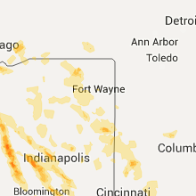
Indiana
| Local Time | Report Details |
|---|---|
| 9:55 AM EDT | Large tree limb down in noble county IN, 26.7 miles NNW of Fort Wayne, IN |
| 10:50 AM EDT | Concrete plant with roof blown off building. bay doors were open at the time. time esitmate in tippecanoe county IN, 61.5 miles NW of Indianapolis, IN |
| 10:50 AM EDT | Tree down - relayed by county em in cass county IN, 74.1 miles W of Fort Wayne, IN |
| 11:10 AM EDT | Tree down north of frankfort in clinton county IN, 41.4 miles NNW of Indianapolis, IN |
| 11:36 AM EDT | Hague and 202nd street in hamilton county IN, 21.2 miles NNE of Indianapolis, IN |
| 11:39 AM EDT | Storm damage reported in hendricks county IN, 13.7 miles WNW of Indianapolis, IN |
| 11:39 AM EDT | Storm damage reported in hendricks county IN, 18.5 miles WNW of Indianapolis, IN |
| 11:40 AM EDT | Tree limbs downed in hamilton county IN, 21.2 miles NNE of Indianapolis, IN |
| 11:40 AM EDT | *** 1 inj *** driver injured by a falling tree. reported by wth in boone county IN, 14.2 miles NNW of Indianapolis, IN |
| 11:42 AM EDT | Damage to pnc bank sign at intersection of ford and oak street in boone county IN, 14.2 miles NNW of Indianapolis, IN |
| 11:42 AM EDT | Storm damage reported in marion county IN, 8.6 miles WNW of Indianapolis, IN |
| 11:43 AM EDT | Large tree downed along county road 300s in boone county IN, 19.3 miles NNW of Indianapolis, IN |
| 11:44 AM EDT | A few trees down at 86th street and zionsville roa in marion county IN, 8.3 miles NW of Indianapolis, IN |
| 11:45 AM EDT | Trees and power lines down in randolph county IN, 62.8 miles S of Fort Wayne, IN |
| 11:50 AM EDT | Multiple trees down near rockville and country club roa in marion county IN, 0.9 miles N of Indianapolis, IN |
| 11:52 AM EDT | Multiple trees snapped or uprooted in randolph county IN, 58.3 miles ENE of Indianapolis, IN |
| 11:56 AM EDT | Several large trees downed at 10th street near interstate 46 in marion county IN, 8 miles W of Indianapolis, IN |
| 12:07 PM EDT | Trees down near minnesota and meridian streets. time estimated from rada in marion county IN, 0.9 miles N of Indianapolis, IN |
| 12:12 PM EDT | Tree down near us31 and smith valley road. time estimated from radar in johnson county IN, 10.4 miles SSE of Indianapolis, IN |
| 12:18 PM EDT | Storm damage reported in shelby county IN, 19.3 miles SE of Indianapolis, IN |
| 12:19 PM EDT | Storm damage reported in marion county IN, 11.3 miles SW of Indianapolis, IN |
| 12:20 PM EDT | Tree limbs down on garden drive in madison county IN, 27.1 miles NE of Indianapolis, IN |
| 12:30 PM EDT | Tree down across car at oak and sycamore streets. time esitmate in boone county IN, 14.2 miles NNW of Indianapolis, IN |
| 12:37 PM EDT | 10-12 inch limb down across w 8th street. time estimated from rada in fayette county IN, 51.3 miles NW of Cincinnati, OH |
| 1:05 PM EDT | Numerous trees down...one on garage. time estimated from rada in bartholomew county IN, 46.9 miles SSE of Indianapolis, IN |
| 1:09 PM EDT | Sign blown down near 38th and moller in marion county IN, 0.9 miles N of Indianapolis, IN |
| 1:10 PM EDT | Numerous trees down along us route 31 between columbus and seymour. us 31 impassible in a few spot in bartholomew county IN, 47.6 miles SSE of Indianapolis, IN |
| 1:30 PM EDT | Trees and power lines downed near steak and shake on us route 5 in jackson county IN, 57.4 miles SSE of Indianapolis, IN |
| 1:42 PM EDT | Trees down countywid in jefferson county IN, 55.4 miles N of Louisville, KY |
| 1:56 PM EDT | Tree across highway 62 near nab in clark county IN, 42 miles NNE of Louisville, KY |
| 2:07 PM EDT | Trees and power lines down 102 sr 62 in new washingto in clark county IN, 42 miles NNE of Louisville, KY |
| 2:09 PM EDT | Trees down in various locations in eastern clark count in clark county IN, 39.9 miles NNE of Louisville, KY |
| 2:20 PM EDT | Tree down in roadway charlestown pike and us 62 in clark county IN, 24.3 miles N of Louisville, KY |
| 2:25 PM EDT | Several large trees limbs down and large trees uprooted. one was across a power lin in clark county IN, 23.8 miles N of Louisville, KY |
| 4:01 PM EDT | Quarter sized hail reported near Corydon, IN, 28.5 miles NW of Louisville, KY |
| 7:45 PM CDT | Golf Ball sized hail reported near East Chicago, IN, 19.7 miles SSE of Chicago, IL, indianapolis blvd and michigan ave. |
| 7:50 PM CDT | Golf Ball sized hail reported near East Chicago, IN, 18.7 miles SSE of Chicago, IL |
| 7:55 PM CDT | Golf Ball sized hail reported near Gary, IN, 24.8 miles SE of Chicago, IL |
| 8:55 PM EDT | Quarter sized hail reported near Leesburg, IN, 39.9 miles WNW of Fort Wayne, IN |
| 8:00 PM CDT | Baseball sized hail reported near East Chicago, IN, 19.7 miles SSE of Chicago, IL, 3900 block of hohman ave. |
| 9:24 PM EDT | Trees down in putnam county IN, 32.5 miles W of Indianapolis, IN |
| 9:24 PM EDT | Tree limbs or trees down. reported via twitter in montgomery county IN, 44.1 miles WNW of Indianapolis, IN |
| 9:26 PM EDT | Report of a tree down near cromwell. no information on size/healt in noble county IN, 34.8 miles NW of Fort Wayne, IN |
| 9:30 PM EDT | Numerous trees and power poles down. time estimate in putnam county IN, 30 miles W of Indianapolis, IN |
| 9:31 PM EDT | Quarter sized hail reported near Danville, IN, 19.7 miles W of Indianapolis, IN, north side of town. accompanied with estimated 45 mph wind. |
| 9:42 PM EDT | Storm damage reported in hendricks county IN, 19.7 miles W of Indianapolis, IN |
| 9:45 PM EDT | Ping Pong Ball sized hail reported near Danville, IN, 17.9 miles W of Indianapolis, IN, estimated of 1 to 1.5-inch hail on cartersburg road |
| 9:47 PM EDT | Large tree down across cr-44 between cr 37 and cr 3 in elkhart county IN, 44.5 miles NW of Fort Wayne, IN |
| 9:55 PM EDT | Report of a tree down. no additional information on size/health of the tre in noble county IN, 36.8 miles NW of Fort Wayne, IN |
| 10:00 PM EDT | Small tree limbs down...less than 2 inches in diameter in hendricks county IN, 20.7 miles WSW of Indianapolis, IN |
| 10:00 PM EDT | Quarter sized hail reported near Monrovia, IN, 21.8 miles SW of Indianapolis, IN |
| 10:02 PM EDT | Power lines and numerous trees down. time estimated from radar and general recollection of time by spotte in morgan county IN, 27.9 miles SSW of Indianapolis, IN |
| 10:04 PM EDT | Quarter sized hail reported near Indianapolis, IN, 6.7 miles SW of Indianapolis, IN |
| 10:22 PM EDT | Storm damage reported in morgan county IN, 27.9 miles SSW of Indianapolis, IN |
| 10:35 PM EDT | Heard 3 trees fall in the woods off of lanam ridge road. estimated wind of 50 to 60 mp in brown county IN, 35.1 miles SSW of Indianapolis, IN |
| 10:53 PM EDT | Broadcast media reports text from friend reports tree down on his house and power outages in parts of town. time estimated from rada in bartholomew county IN, 40.5 miles SSE of Indianapolis, IN |
| 10:56 PM EDT | Storm damage reported in bartholomew county IN, 40.5 miles SSE of Indianapolis, IN |
| 11:00 PM EDT | Located at central avenue in bartholomew county IN, 40.5 miles SSE of Indianapolis, IN |
| 11:23 PM EDT | Quarter sized hail reported near Zionsville, IN, 14.2 miles NNW of Indianapolis, IN |
| 12:15 AM EDT | Two trees down on route 262 in ohio county IN, 26.8 miles WSW of Cincinnati, OH |
| 1:10 AM EDT | Multiple reports of tree limbs down around speedway. time estimated from rada in marion county IN, 5.6 miles WNW of Indianapolis, IN |
| 2:04 AM EDT | Numerous trees down shortly before and after this time...several on vehicles. significant tree damage reported at crawfordsville and lynhurst. damage also at gerrard an in marion county IN, 5.6 miles WNW of Indianapolis, IN |
| 2:20 AM EDT | Indiana dhs called reporting trees down...power lines down and damage to homes from around 10th and tibbs street to meridian street and thompson roa in marion county IN, 1.2 miles WSW of Indianapolis, IN |
| 2:20 AM EDT | Street flooding one foot deepat winston and 22nd street. utility lines down on 22nd and fisher blocking roa in marion county IN, 5.6 miles WNW of Indianapolis, IN |
| 2:20 AM EDT | A few tree branches down up to 1.5 inches thick and several feet thick in marion county IN, 1.7 miles ESE of Indianapolis, IN |
| 2:36 AM EDT | Widespread flooding along wiht multiple trees and powerlines dow in brown county IN, 39.4 miles S of Indianapolis, IN |
| 3:45 AM EDT | Multiple trees down in the count in jefferson county IN, 52.9 miles WSW of Cincinnati, OH |
| 5:48 AM EDT | Tree limbs fell on vehicle and fence in knox county IN, 45.2 miles NNE of Evansville, IN |
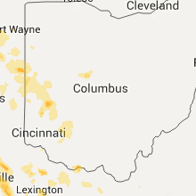
Ohio
| Local Time | Report Details |
|---|---|
| 12:21 PM EDT | Multiple trees down across the count in preble county OH, 54.2 miles NNW of Cincinnati, OH |
| 12:37 PM EDT | One large tree down caused significant damage to car. time estimated from rada in clark county OH, 44.1 miles W of Columbus, OH |
| 12:50 PM EDT | One large tree down. time estimated from rada in montgomery county OH, 47.4 miles NNE of Cincinnati, OH |
| 12:56 PM EDT | One limb down. time estimated from rada in greene county OH, 50.3 miles NE of Cincinnati, OH |
| 1:01 PM EDT | Large tree down on power lines at houge rd and eaton rd. time estimated from rada in butler county OH, 24.7 miles N of Cincinnati, OH |
| 1:06 PM EDT | Tree down due to thunderstorm wind on roxanna new burlington roa in greene county OH, 43.7 miles NE of Cincinnati, OH |
| 1:07 PM EDT | 4 to 6 inch diameter tree branches down due to win in montgomery county OH, 44.8 miles N of Cincinnati, OH |
| 1:07 PM EDT | One large limb down. time estimated from rada in warren county OH, 34.3 miles NNE of Cincinnati, OH |
| 1:09 PM EDT | Moderately sized tree split in half on ballard drive. time estimated from rada in warren county OH, 36.3 miles NNE of Cincinnati, OH |
| 1:17 PM EDT | Large limb down at wilmington court apartments. time estimated from rada in clinton county OH, 43.6 miles NE of Cincinnati, OH |
| 1:20 PM EDT | One large limb down at michigan ave and b stree in clinton county OH, 43.6 miles NE of Cincinnati, OH |
| 1:20 PM EDT | Trees down near quaker way and fife ave. time estimated from rada in clinton county OH, 43.7 miles ENE of Cincinnati, OH |
| 1:24 PM EDT | Multiple large limbs down across us-62. time estimated from rada in fayette county OH, 39.9 miles SW of Columbus, OH |
| 1:25 PM EDT | 14 inch diameter branch down. time estimated from rada in hamilton county OH, 8.6 miles N of Cincinnati, OH |
| 1:26 PM EDT | One large tree uprooted. time estimated from rada in hamilton county OH, 8.2 miles NNW of Cincinnati, OH |
| 1:29 PM EDT | Large tree down. time estimated from rada in hamilton county OH, 2.6 miles WNW of Cincinnati, OH |
| 1:29 PM EDT | Multiple large trees limbs down near grandview avenue and fleming street. time estimated from rada in hamilton county OH, 1.6 miles NE of Cincinnati, OH |
| 1:30 PM EDT | Tree and large limbs down in east walnut hills due to win in hamilton county OH, 2.1 miles NE of Cincinnati, OH |
| 1:30 PM EDT | Several large trees down across north avondale area. time estimated from rada in hamilton county OH, 3.1 miles NNE of Cincinnati, OH |
| 1:34 PM EDT | One tree down across keys crescent near madison rd. time estimated from rada in hamilton county OH, 2.5 miles NE of Cincinnati, OH |
| 1:34 PM EDT | Numerous reports of trees and wires down due to thunderstorm wind in hamilton county OH, 0.5 miles SSW of Cincinnati, OH |
| 1:36 PM EDT | 8-10 inch diameter tree uprooted near the 1100 block of seymour avenue. time estimated from rada in hamilton county OH, 5.9 miles NNE of Cincinnati, OH |
| 1:39 PM EDT | 3 inch diameter branches broken off and a 3 foot diameter portion of a tree was split by the wind. time estimated from rada in hamilton county OH, 4.4 miles N of Cincinnati, OH |
| 1:44 PM EDT | Tree fell onto garage in eastgate area. time estimated from rada in clermont county OH, 12.1 miles E of Cincinnati, OH |
| 1:45 PM EDT | Several trees down across east walnut hills area. time estimated from rada in hamilton county OH, 2.1 miles NE of Cincinnati, OH |
| 1:46 PM EDT | Numerous trees down on several houses. prouty lane and ivy hill roads along with state route 62. garage door blown in and wall blown outward from one residence...along in highland county OH, 47.7 miles E of Cincinnati, OH |
| 1:46 PM EDT | One tree limb down. time estimated from rada in ross county OH, 39.9 miles SSW of Columbus, OH |
| 1:48 PM EDT | Tree limb down on fence. time estimated from rada in clermont county OH, 17.5 miles E of Cincinnati, OH |
| 1:56 PM EDT | Small tree uprooted. time estimated from rada in clermont county OH, 16.2 miles SE of Cincinnati, OH |
| 2:04 PM EDT | One large tree down in front of mt logan elementary school. time estimated from rada in ross county OH, 43 miles S of Columbus, OH |
| 2:08 PM EDT | Large tree down caused minor house damag in adams county OH, 51.6 miles ESE of Cincinnati, OH |
| 2:10 PM EDT | Significant wind damage to hom in adams county OH, 51.6 miles ESE of Cincinnati, OH |
| 2:11 PM EDT | Large limb down. time estimated from rada in clermont county OH, 28.5 miles SE of Cincinnati, OH |
| 2:13 PM EDT | Tree down on house. time estimated from rada in brown county OH, 36.4 miles ESE of Cincinnati, OH |
| 2:32 PM EDT | Several trees and power poles dow in pike county OH, 58.8 miles S of Columbus, OH |
| 2:32 PM EDT | Tree down on mobile home on ruth ann drive. time estimated from rada in scioto county OH, 74 miles S of Columbus, OH |
| 2:32 PM EDT | Tree down on porch on millers run-fallen timber road. time estimated from rada in scioto county OH, 71.9 miles S of Columbus, OH |
| 2:33 PM EDT | Tree down on house caused roof to cave in. time estimated from rada in scioto county OH, 70.6 miles S of Columbus, OH |
| 2:37 PM EDT | Tree limb fell on top of car. time estimated from rada in brown county OH, 49.8 miles SE of Cincinnati, OH |
| 2:52 PM EDT | Sr 52 closed at buena vista due to tree down across road. more than 50 other trees reported down on roadways across scioto count in scioto county OH, 74.7 miles ESE of Cincinnati, OH |
| 2:58 PM EDT | Numerous trees down across madison township in scioto county...especially along white gravel...warren hill...richard...dewey...and kulp road in scioto county OH, 74.3 miles S of Columbus, OH |
| 3:15 PM EDT | Jackson county 911 reports numerous trees down across the county... in the oak hill area in jackson county OH, 63.6 miles NW of Charleston, WV |
| 3:15 PM EDT | Tree branches down in roads in oak hill in jackson county OH, 63.1 miles NW of Charleston, WV |
| 3:54 PM EDT | Trees down in athali in lawrence county OH, 38 miles WNW of Charleston, WV |
| 11:49 PM EDT | Quarter sized hail reported near Dayton, OH, 54.5 miles NNE of Cincinnati, OH |
| 11:58 PM EDT | One tree down. time estimated from rada in montgomery county OH, 47.2 miles NNE of Cincinnati, OH |
| 11:58 PM EDT | Large tree fell into home on peach orchard avenue. time estimated from rada in montgomery county OH, 45.3 miles NNE of Cincinnati, OH |
| 12:01 AM EDT | Large tree down. time estimated from rada in montgomery county OH, 46.8 miles NNE of Cincinnati, OH |
| 12:55 AM EDT | A couple trees down on antioch rd. time estimated from rada in clinton county OH, 46.4 miles ENE of Cincinnati, OH |
| 1:14 AM EDT | One tree down on blain hwy near route 77 in ross county OH, 49.9 miles S of Columbus, OH |
| 1:22 AM EDT | One tree down. time estimated from rada in hocking county OH, 40.5 miles SE of Columbus, OH |
Georgia
| Local Time | Report Details |
|---|---|
| 1:05 PM EDT | Tree down on power line at 72 west 1st street. time estimated by rada in liberty county GA, 24.3 miles SW of Savannah, GA |
| 3:50 PM EDT | The dooly county emergency manager reported a three-sided metal barn and several trees blown down east of drayto in dooly county GA, 74 miles WNW of Douglas, GA |
| 5:00 PM EDT | Pine tree fell on a power line on armena road...likely due to outflow winds from storm to the nort in lee county GA, 85.3 miles WNW of Douglas, GA |
| 8:01 PM EDT | Power outages and a few trees down in tow in treutlen county GA, 62.1 miles NNE of Douglas, GA |
| 8:41 PM EDT | Tattnall county dispatch reports 2 trees down on hw-292 near the intersection with hillview roa in tattnall county GA, 60.2 miles W of Savannah, GA |
| 8:50 PM EDT | Evans county 911 reports a tree down on jim sapp road near hw-12 in evans county GA, 51.5 miles W of Savannah, GA |
| 8:50 PM EDT | Evans county 911 reports a tree down on hw-301 near hw-16 in evans county GA, 47.1 miles WNW of Savannah, GA |
| 8:54 PM EDT | Evans county 911 reports a tree down on cedar creek road near hw-16 in evans county GA, 49.1 miles W of Savannah, GA |
| 8:56 PM EDT | The bulloch county 911 call center reported several trees down along kennedy pond road. 1 tree was down on a house and another tree was down on a ca in bulloch county GA, 46 miles WNW of Savannah, GA |
| 9:05 PM EDT | Evans county 911 reports 2 power lines down on perkins mill road near benjamin road as well as a tree down on perry road near benjamin roa in evans county GA, 48.9 miles W of Savannah, GA |
North Carolina
| Local Time | Report Details |
|---|---|
| 1:20 PM EDT | Report of 2 pine trees down on roadway near 3000 block of hwy 210 w. time estimated by rada in pender county NC, 14.6 miles NE of Wilmington, NC |
| 3:43 PM EDT | Half Dollar sized hail reported near Longwood, NC, 38.2 miles WSW of Wilmington, NC, report of half dollar size hail. |
| 4:00 PM EDT | Quarter sized hail reported near Tabor City, NC, 53.3 miles W of Wilmington, NC, report of quarter size hail on pireway rd. |
| 4:00 PM EDT | Quarter sized hail reported near Longwood, NC, 37.9 miles WSW of Wilmington, NC, report of quarter size hail on pireway rd. |
| 7:25 PM EDT | Multiple trees blown down in madison county NC, 57.2 miles SW of Bristol, TN |
| 7:25 PM EDT | Trees down on elk creek road via social medi in watauga county NC, 44.8 miles SE of Bristol, TN |
| 7:36 PM EDT | Multiple trees blown down se of marshall... n in madison county NC, 61.5 miles SSW of Bristol, TN |
| 7:50 PM EDT | Two trees dow in stokes county NC, 70.4 miles SSW of Roanoke, VA |
| 8:00 PM EDT | Trees down sw central d in caldwell county NC, 60.8 miles SE of Bristol, TN |
| 8:02 PM EDT | Two trees blown down by thunderstorm wind in stokes county NC, 69.8 miles S of Roanoke, VA |
| 8:02 PM EDT | Trees down off dreamfields lane sw of lenoir... n in caldwell county NC, 61 miles NW of Charlotte, NC |
| 8:06 PM EDT | Trees in roadwa in randolph county NC, 56.7 miles NE of Charlotte, NC |
| 8:10 PM EDT | Trees blown down dudley shoals d in caldwell county NC, 52 miles NW of Charlotte, NC |
| 8:12 PM EDT | Tree blown down on a house in mcdowell county NC, 60.6 miles NNE of Greenville, SC |
| 8:15 PM EDT | Numerous trees and power lines down across the northern half of the count in forsyth county NC, 76.2 miles S of Roanoke, VA |
| 8:16 PM EDT | Siding and gutters blown off the building of the eden rescue squa in rockingham county NC, 53.7 miles SSE of Roanoke, VA |
| 8:24 PM EDT | 911 call center reports a tree down on a house w/ intrusion. damage estimate unknow in rockingham county NC, 52.3 miles SSE of Roanoke, VA |
| 8:24 PM EDT | Large tree blown down in catawba county NC, 45.2 miles NW of Charlotte, NC |
| 8:25 PM EDT | Trees down on power lines highway 10 west in catawba county NC, 41.5 miles NW of Charlotte, NC |
| 8:25 PM EDT | Trees blown down by thunderstorm wind in stokes county NC, 61.3 miles SSW of Roanoke, VA |
| 8:26 PM EDT | Multiple trees down in mountain home and etowah... n in henderson county NC, 37.6 miles N of Greenville, SC |
| 8:30 PM EDT | Gso asos reports 69 mph wind gus in guilford county NC, 75.9 miles WNW of Raleigh, NC |
| 8:31 PM EDT | Several trees fell into powerpoles closing highway 14 within the city of eden... n in rockingham county NC, 53.6 miles SSE of Roanoke, VA |
| 8:36 PM EDT | Caswell county 911 center reported that a tree was down on burton-chapel road in the mebane are in caswell county NC, 51.7 miles NW of Raleigh, NC |
| 8:45 PM EDT | Quarter sized hail reported near Star, NC, 55.6 miles ENE of Charlotte, NC, quarter size hail 7 miles north of troy. |
| 8:46 PM EDT | Numerous downed trees and power lines in the union ridge and pleasant grove area in alamance county NC, 51 miles NW of Raleigh, NC |
| 8:50 PM EDT | Tree blown down on a she in burke county NC, 54.6 miles NW of Charlotte, NC |
| 8:53 PM EDT | Awning blown off a house. estimated 50-60 mph wind in cabarrus county NC, 22.2 miles NNE of Charlotte, NC |
| 9:06 PM EDT | Caswell county 911 center reported that a power line was down along u.s. 158 in the casville are in caswell county NC, 63.6 miles NW of Raleigh, NC |
| 9:36 PM EDT | Half Dollar sized hail reported near Asheboro, NC, 65.8 miles W of Raleigh, NC |
| 9:57 PM EDT | Trees down...including one through the roof of a residence...near king view rd. and burney r in randolph county NC, 62.5 miles ENE of Charlotte, NC |
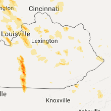
Kentucky
| Local Time | Report Details |
|---|---|
| 1:30 PM EDT | Tree and large limbs down in east walnut hills due to win in campbell county KY, 1.9 miles ESE of Cincinnati, OH |
| 1:39 PM EDT | Multiple trees and limbs down. time estimated from rada in campbell county KY, 3.5 miles ESE of Cincinnati, OH |
| 1:40 PM EDT | Tree down due to wind on upland avenue in fort wrigh in kenton county KY, 4.3 miles SSW of Cincinnati, OH |
| 1:41 PM EDT | Large tree uprooted at alanna drive and themla lane. time estimated from rada in campbell county KY, 5.4 miles SSE of Cincinnati, OH |
| 1:44 PM EDT | Large tree down near us-27 and martha lanyne collins blvd. time estimated from rada in campbell county KY, 6 miles SSE of Cincinnati, OH |
| 1:45 PM EDT | Numerous limbs and a few trees down across the cit in campbell county KY, 2.4 miles E of Cincinnati, OH |
| 1:50 PM EDT | Large tree uprooted along 43rd street. time estimated from rada in kenton county KY, 4.6 miles S of Cincinnati, OH |
| 1:55 PM EDT | Tree on power line and hom in estill county KY, 0.3 miles E of Irvine, KY |
| 1:55 PM EDT | Widespread trees down in irvine including the following locations - pea ridge road... noland creek rd... spout springs rd... winston rd... francis street... cressy roa in estill county KY, 0.3 miles E of Irvine, KY |
| 1:59 PM EDT | Several 4 to 5 inch diameter branches down and damage to metal barn roof. time estimated from rada in gallatin county KY, 30.1 miles SW of Cincinnati, OH |
| 2:02 PM EDT | Several large limbs down on house and power lines. time estimated from rada in carroll county KY, 46 miles SW of Cincinnati, OH |
| 2:03 PM EDT | Trees down along route 22 in owen county KY, 42.8 miles SW of Cincinnati, OH |
| 2:04 PM EDT | Trees down in northern grant count in grant county KY, 24.3 miles SSW of Cincinnati, OH |
| 2:08 PM EDT | Trees down along route route 127 north of owento in owen county KY, 40.6 miles SSW of Cincinnati, OH |
| 2:15 PM EDT | Trees down along route 22 west of dry ridg in grant county KY, 30.5 miles SSW of Cincinnati, OH |
| 2:16 PM EDT | Large trees down and portion of roof ripped off structure. time estimated from rada in pendleton county KY, 30.9 miles SSE of Cincinnati, OH |
| 2:16 PM EDT | Tree down near kathy lane and us-27. time estimated from rada in pendleton county KY, 32.4 miles SSE of Cincinnati, OH |
| 2:20 PM EDT | Storm damage reported in bracken county KY, 35.5 miles SE of Cincinnati, OH |
| 2:24 PM EDT | Pic of tree dow in harrison county KY, 50.7 miles SSE of Cincinnati, OH |
| 2:26 PM EDT | Tree limb down on highway 2 in jefferson county KY, 25.1 miles NNE of Louisville, KY |
| 2:30 PM EDT | Trees reported down in henry county KY, 42 miles NE of Louisville, KY |
| 2:30 PM EDT | Several trees down in maysville due to thunderstorm wind in mason county KY, 51.9 miles SE of Cincinnati, OH |
| 2:32 PM EDT | One large tree down. time estimated from rada in bracken county KY, 42.7 miles SE of Cincinnati, OH |
| 2:34 PM EDT | Trees dow in harrison county KY, 41 miles S of Cincinnati, OH |
| 2:36 PM EDT | Picture of trees and power lines down across north highway 2 in harrison county KY, 44.7 miles SSE of Cincinnati, OH |
| 2:38 PM EDT | New roof torn off barn and very large trees down. time estimated from rada in robertson county KY, 48.5 miles SSE of Cincinnati, OH |
| 2:39 PM EDT | Tree fell on caudill road off of hwy 70 in morgan county KY, 40.8 miles ENE of Irvine, KY |
| 2:41 PM EDT | Tree fell on hous in morgan county KY, 42.1 miles ENE of Irvine, KY |
| 2:41 PM EDT | Tree blocking long run roa in jefferson county KY, 24.8 miles NE of Louisville, KY |
| 2:42 PM EDT | Trees reported dow in scott county KY, 55.4 miles NW of Irvine, KY |
| 2:43 PM EDT | Trees down at brownsboro and moccasi in jefferson county KY, 16.1 miles N of Louisville, KY |
| 2:44 PM EDT | Picture of tree down near moorefield road in nicholas county KY, 42.8 miles N of Irvine, KY |
| 2:44 PM EDT | Trees down at 39th and broadwa in jefferson county KY, 16.1 miles N of Louisville, KY |
| 2:44 PM EDT | Trees down at 40th and broadwa in jefferson county KY, 16.1 miles N of Louisville, KY |
| 2:44 PM EDT | Trees down at 39th and broadwa in jefferson county KY, 16.1 miles N of Louisville, KY |
| 2:45 PM EDT | Wires down at jewish academ in jefferson county KY, 17.1 miles NNE of Louisville, KY |
| 2:45 PM EDT | Trees blown down across the count in grant county KY, 42 miles S of Cincinnati, OH |
| 2:47 PM EDT | Trees down at old henry and factory lan in jefferson county KY, 16.1 miles N of Louisville, KY |
| 2:48 PM EDT | Trees down on highway 227 and across the count in owen county KY, 50.2 miles SSW of Cincinnati, OH |
| 2:49 PM EDT | Trees down countywid in shelby county KY, 30.5 miles ENE of Louisville, KY |
| 2:52 PM EDT | Storm damage reported in franklin county KY, 48.9 miles ENE of Louisville, KY |
| 2:52 PM EDT | Trees dow in fleming county KY, 52.9 miles NNE of Irvine, KY |
| 2:54 PM EDT | Numerous trees down across the city and the entire county along with power line in nicholas county KY, 42.2 miles N of Irvine, KY |
| 2:54 PM EDT | Trees dow in shelby county KY, 24.8 miles ENE of Louisville, KY |
| 2:57 PM EDT | Picture of large tree down in scott county KY, 47.2 miles NW of Irvine, KY |
| 3:00 PM EDT | Downed tree limbs and power lines at garrad par in bourbon county KY, 38.9 miles NNW of Irvine, KY |
| 3:05 PM EDT | Numerous trees were blown down along cranston road west of morehea in rowan county KY, 43.3 miles NE of Irvine, KY |
| 3:06 PM EDT | Picture of tree dow in bullitt county KY, 10.1 miles ENE of Louisville, KY |
| 3:18 PM EDT | Trees are down. some traffic lights are without powe in woodford county KY, 47.8 miles WNW of Irvine, KY |
| 3:22 PM EDT | Tree down in road at s. ashland and central in fayette county KY, 36.2 miles NW of Irvine, KY |
| 3:24 PM EDT | Pic of tree down in the road at old richmond and s. clevelan in fayette county KY, 26.4 miles NW of Irvine, KY |
| 3:26 PM EDT | Mobile home overturned at the intersection of chase lane and ficklin r in montgomery county KY, 21.8 miles NNE of Irvine, KY |
| 3:26 PM EDT | Trees down county wide including the following roads- tabor road... science ridge... bunker hill... twin oaks... nest egg... cunningham lane... howards mill... camargo in montgomery county KY, 24.9 miles N of Irvine, KY |
| 3:27 PM EDT | Numerous trees down around the cit in fayette county KY, 35.4 miles NW of Irvine, KY |
| 3:28 PM EDT | Multiple trees across road at horton flat. has traffic backed u in elliott county KY, 62.1 miles ENE of Irvine, KY |
| 3:28 PM EDT | A shed was destroyed and trees fell at the same residence with one falling onto the hom in elliott county KY, 63 miles ENE of Irvine, KY |
| 3:30 PM EDT | Numerous trees were blown down county wid in rowan county KY, 44.7 miles NE of Irvine, KY |
| 3:32 PM EDT | Tree down in the monticello subdivision on cartier driv in fayette county KY, 33 miles WNW of Irvine, KY |
| 3:39 PM EDT | Tree fell on caudill road off of hwy 70 in morgan county KY, 40.8 miles ENE of Irvine, KY |
| 3:40 PM EDT | Trained spotter reports numerous trees down... power lines and telephone lines down... and a tree on a house with entrapment in the olive hill area in carter county KY, 60.3 miles NE of Irvine, KY |
| 3:41 PM EDT | Tree fell on hous in morgan county KY, 42.1 miles ENE of Irvine, KY |
| 3:48 PM EDT | Tree down on power line on whitlock rd in madison county KY, 25.9 miles WNW of Irvine, KY |
| 3:50 PM EDT | Trees down in the fallsburg are in lawrence county KY, 57.4 miles WSW of Charleston, WV |
| 3:50 PM EDT | Tree down on high st in madison county KY, 18.2 miles W of Irvine, KY |
| 3:53 PM EDT | Power lines down in the road on north 1st s in madison county KY, 17.6 miles WNW of Irvine, KY |
| 3:54 PM EDT | Tree down on mobile home at rane in pike county KY, 65.1 miles N of Bristol, TN |
| 4:00 PM EDT | Numerous trees and power poles down in and near louis in lawrence county KY, 54.8 miles WSW of Charleston, WV |
| 4:00 PM EDT | Tree on house in the louisa city limit in lawrence county KY, 54.8 miles WSW of Charleston, WV |
| 4:00 PM EDT | Trees reported dow in clark county KY, 23.8 miles NNW of Irvine, KY |
| 4:00 PM EDT | Trees and powerlines down throughout lawrence county. tree on structure off cherryville rd in southern lawrence count in lawrence county KY, 58.9 miles WSW of Charleston, WV |
| 4:01 PM EDT | Tree down on power lines and a hous in estill county KY, 0.3 miles E of Irvine, KY |
| 4:10 PM EDT | Tree on power line on oak st in madison county KY, 20 miles WSW of Irvine, KY |
| 4:10 PM EDT | Powerlines were blown dow in johnson county KY, 64.4 miles E of Irvine, KY |
| 4:15 PM EDT | Downed tree in magoffin county KY, 52.3 miles E of Irvine, KY |
| 4:15 PM EDT | Trees were reported to have been blown dow in breathitt county KY, 29.5 miles E of Irvine, KY |
| 4:16 PM EDT | A tree was blown down near the vancleve fire dep in breathitt county KY, 31.6 miles E of Irvine, KY |
| 4:18 PM EDT | Tree on house on sand branch rd near ky 828 in lawrence county KY, 64.4 miles WSW of Charleston, WV |
| 4:20 PM EDT | Trees down near home off highway 30w. trees were 15 to 25 feet tall and estimated at around 6 inches in diamete in breathitt county KY, 31.4 miles ESE of Irvine, KY |
| 4:20 PM EDT | Numerous trees down on hwy 30 eas in breathitt county KY, 37.2 miles ESE of Irvine, KY |
| 4:20 PM EDT | Downed tree in floyd county KY, 66.1 miles E of Irvine, KY |
| 4:20 PM EDT | Trees and power lines across hwy 321 near the highland hospita in floyd county KY, 66 miles E of Irvine, KY |
| 4:20 PM EDT | Trees were blown down on ky highway 4 in johnson county KY, 68.7 miles E of Irvine, KY |
| 4:23 PM EDT | Numerous trees and powerlines were blown dow in floyd county KY, 69.9 miles E of Irvine, KY |
| 4:23 PM EDT | Tree down on house in the picnic hill subdivisio in breathitt county KY, 34 miles ESE of Irvine, KY |
| 4:25 PM EDT | Numerous trees... large limbs and power lines dow in morgan county KY, 52.4 miles ENE of Irvine, KY |
| 4:25 PM EDT | Numerous trees... large limbs and power lines dow in breathitt county KY, 34.6 miles SE of Irvine, KY |
| 4:25 PM EDT | Large limbs down at the happy churc in breathitt county KY, 36.7 miles ESE of Irvine, KY |
| 4:30 PM EDT | Tree across roa in owsley county KY, 25.4 miles SSE of Irvine, KY |
| 4:45 PM EDT | Large tree limbs and a tree were blown dow in perry county KY, 52.6 miles ESE of Irvine, KY |
| 4:45 PM EDT | A tree was blown down on a hom in pike county KY, 60.2 miles SW of Charleston, WV |
| 4:45 PM EDT | Tree and large limbs blocking both lanes. power lines dow in perry county KY, 50.5 miles SE of Irvine, KY |
| 4:47 PM EDT | Tree dow in pike county KY, 59.7 miles NNW of Bristol, TN |
| 4:49 PM EDT | Trees were reported to have been blown dow in perry county KY, 51 miles SE of Irvine, KY |
| 4:50 PM EDT | Tree down across hwy 49 in laurel county KY, 36.1 miles SSW of Irvine, KY |
| 4:50 PM EDT | A tree was blown dow in rockcastle county KY, 21.2 miles SW of Irvine, KY |
| 4:51 PM EDT | Large limbs blown dow in pike county KY, 63.3 miles NNW of Bristol, TN |
| 4:52 PM EDT | Tree and numerous limbs dow in knott county KY, 60.3 miles ESE of Irvine, KY |
| 4:54 PM EDT | Tree down on mobile home at rane in pike county KY, 65.1 miles N of Bristol, TN |
| 4:54 PM EDT | Downed trees in perry county KY, 52.7 miles SE of Irvine, KY |
| 4:58 PM EDT | Tree dow in pike county KY, 66 miles NNW of Bristol, TN |
| 5:02 PM EDT | Trees and power lines down on us highway 42 in leslie county KY, 57.4 miles SE of Irvine, KY |
| 5:04 PM EDT | A tree was blown down onto ky highway in letcher county KY, 55.8 miles NW of Bristol, TN |
| 5:10 PM EDT | Trees down along ky highway 7 at the perry and letcher county line in letcher county KY, 59 miles NW of Bristol, TN |
| 5:15 PM EDT | Multiple large tree limbs down in excess of 3 inches in diameter in bell county KY, 58.5 miles SSE of Irvine, KY |
| 5:15 PM EDT | Large limbs blown dow in letcher county KY, 49 miles NNW of Bristol, TN |
| 5:15 PM EDT | Large tree limbs were blown dow in letcher county KY, 48.5 miles NW of Bristol, TN |
| 5:15 PM EDT | A tree was blown dow in pike county KY, 54.6 miles NNW of Bristol, TN |
| 5:23 PM EDT | A tree was uprooted and fell onto a hom in harlan county KY, 50.3 miles WNW of Bristol, TN |
| 5:28 PM EDT | Half Dollar sized hail reported near Raywick, KY, 33.4 miles SSE of Louisville, KY |
| 5:28 PM EDT | A tree was blown down onto a picnic tabl in harlan county KY, 65.4 miles NNE of Knoxville, TN |
| 5:37 PM EDT | Tree reported dow in larue county KY, 28.8 miles S of Louisville, KY |
| 5:49 PM EDT | Roof blown off a barn and trees dow in taylor county KY, 42.8 miles SSE of Louisville, KY |
| 5:51 PM EDT | Storm damage reported in taylor county KY, 39.3 miles SSE of Louisville, KY |
| 5:07 PM CDT | Trees reported dow in green county KY, 49.6 miles SSE of Louisville, KY |
| 5:08 PM CDT | Golf Ball sized hail reported near Greensburg, KY, 49.6 miles SSE of Louisville, KY |
| 5:09 PM CDT | Numerous trees down across the entire count in green county KY, 51.6 miles SSE of Louisville, KY |
| 5:09 PM CDT | Storm damage reported in green county KY, 49.6 miles SSE of Louisville, KY |
| 5:14 PM CDT | Storm damage reported in green county KY, 45.9 miles SSE of Louisville, KY |
| 6:20 PM EDT | Numerous trees dow in taylor county KY, 46.2 miles SSE of Louisville, KY |
| 5:34 PM CDT | Roof blown off a hous in adair county KY, 64.3 miles SSE of Louisville, KY |
| 6:35 PM EDT | Half Dollar sized hail reported near Campbellsville, KY, 49.9 miles SSE of Louisville, KY |
| 5:40 PM CDT | Golf Ball sized hail reported near Columbia, KY, 65.3 miles SSE of Louisville, KY |
| 6:17 PM CDT | Numerous trees dow in metcalfe county KY, 62.6 miles S of Louisville, KY |
| 6:31 PM CDT | Trees reported dow in cumberland county KY, 81.4 miles S of Louisville, KY |
| 6:33 PM CDT | Quarter sized hail reported near Burkesville, KY, 81.2 miles ENE of Nashville, TN |
| 6:42 PM CDT | Numerous trees down across the entire county along with power line in cumberland county KY, 84.8 miles SSE of Louisville, KY |
| 6:53 PM CDT | Quarter sized hail reported near Burkesville, KY, 82.7 miles ENE of Nashville, TN |
| 1:45 AM EDT | Numerous trees down and reported roof damag in trimble county KY, 46.8 miles NNE of Louisville, KY |
| 1:45 AM EDT | Trees reported dow in henry county KY, 42.6 miles NE of Louisville, KY |
| 3:04 AM EDT | Tree down in the 5300 block of zaring mill road. road crews are on scen in shelby county KY, 29.2 miles ENE of Louisville, KY |
| 4:15 AM EDT | Trees down on highway 754 west of bedfor in trimble county KY, 45.9 miles NNE of Louisville, KY |
| 4:47 AM EDT | Trees down on moser road near douglas hill in jefferson county KY, 19.4 miles NNE of Louisville, KY |
| 5:38 AM EDT | Tree dow in fayette county KY, 33.2 miles NW of Irvine, KY |
| 5:40 AM EDT | Measured at the mercer county mesone in mercer county KY, 48.5 miles W of Irvine, KY |
| 5:49 AM EDT | Several trees down in the eastern part of jefferson county including on stony brook drive and hurstbourn in jefferson county KY, 16.2 miles NNE of Louisville, KY |
| 6:08 AM EDT | Trees down at slate lick road and mt. vernon roa in madison county KY, 21.1 miles WSW of Irvine, KY |
| 6:24 AM EDT | Dispatch reports trees down county wide. time estimated from rada in rockcastle county KY, 30.9 miles SW of Irvine, KY |
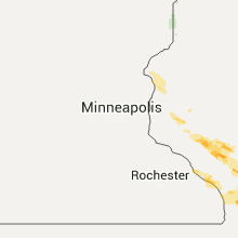
Wisconsin
| Local Time | Report Details |
|---|---|
| 12:30 PM CDT | A few small trees toppled. portion of town out of power from 1230 am to 0400 a in chippewa county WI, 80.7 miles N of La Crosse, WI |
| 12:41 PM CDT | Power lines dow in eau claire county WI, 65.4 miles N of La Crosse, WI |
| 12:46 PM CDT | Power lines dow in eau claire county WI, 68.9 miles N of La Crosse, WI |
| 1:37 PM CDT | Power lines dow in eau claire county WI, 60.2 miles N of La Crosse, WI |
| 1:50 PM CDT | Wires dow in eau claire county WI, 70.6 miles N of La Crosse, WI |
| 3:10 PM CDT | 2 foot diameter down on hous in polk county WI, 52.9 miles NE of Minneapolis, MN |
| 4:08 PM CDT | 10ft trailer blown off the road on highway 1 in la crosse county WI, 10.9 miles NE of La Crosse, WI |
| 4:20 PM CDT | Quarter sized hail reported near Bangor, WI, 16.6 miles NE of La Crosse, WI |
| 4:22 PM CDT | Ping Pong Ball sized hail reported near Bangor, WI, 16.6 miles NE of La Crosse, WI |
| 4:36 PM CDT | Quarter sized hail reported near Sparta, WI, 23.8 miles ENE of La Crosse, WI |
| 4:40 PM CDT | Half Dollar sized hail reported near Cashton, WI, 20.2 miles ESE of La Crosse, WI |
| 5:22 PM CDT | Half Dollar sized hail reported near Viroqua, WI, 29.2 miles SE of La Crosse, WI |
| 5:50 PM CDT | Quarter sized hail reported near Menomonie, WI, 66.1 miles E of Minneapolis, MN |
| 5:55 PM CDT | Tennis Ball sized hail reported near Osseo, WI, 50.5 miles N of La Crosse, WI, many golfball sized... but up to tennis ball size. sky lights are cracked in the home. |
| 6:00 PM CDT | Many trees reported down in the city in richland county WI, 53.9 miles WNW of Madison, WI |
| 6:00 PM CDT | Tree fell on a hous in richland county WI, 53.8 miles SE of La Crosse, WI |
| 6:07 PM CDT | Quarter sized hail reported near Antigo, WI, 41.9 miles SSE of Rhinelander, WI, near hwy 47 and hwy 45. |
| 6:11 PM CDT | Power outage in richland county WI, 53.4 miles WNW of Madison, WI |
| 6:15 PM CDT | 7 homes suffered mainly roof damage one home with major roof damage. numerous trees large branches and power lines dow in richland county WI, 41.8 miles W of Madison, WI |
| 6:15 PM CDT | 2 houses damaged by downed trees and large branches. numerous trees and power lines downe in richland county WI, 53.4 miles WNW of Madison, WI |
| 6:20 PM CDT | Half Dollar sized hail reported near Antigo, WI, 45.7 miles SSE of Rhinelander, WI, public report relayed via wsaw tv. tree branches also snapped off. |
| 6:28 PM CDT | Storm damage reported in sauk county WI, 41.7 miles WNW of Madison, WI |
| 6:30 PM CDT | Time of event estimated by looking at weather radar images. fallen tree on hwy 13 in iowa county WI, 47.3 miles W of Madison, WI |
| 6:30 PM CDT | Time of event estimated by looking at weather radar images. fallen tree on hwy 13 in iowa county WI, 41.5 miles W of Madison, WI |
| 6:30 PM CDT | Ping Pong Ball sized hail reported near Spring Green, WI, 35.1 miles W of Madison, WI, 1.5 inch diameter hail on hwy 23. some larger hail. gusty winds estimated at 50 mph. |
| 6:31 PM CDT | Tree down on hwy in iowa county WI, 40.4 miles W of Madison, WI |
| 6:38 PM CDT | Tree down on roa in columbia county WI, 30.5 miles NNW of Madison, WI |
| 6:47 PM CDT | Tree down on kent roa in columbia county WI, 24.6 miles NNW of Madison, WI |
| 6:49 PM CDT | Another tree down on kent roa in columbia county WI, 23.7 miles NNW of Madison, WI |
| 6:54 PM CDT | Ping Pong Ball sized hail reported near Poynette, WI, 21.9 miles N of Madison, WI, time estimated from radar. |
| 6:58 PM CDT | Ping Pong Ball sized hail reported near Poynette, WI, 24 miles N of Madison, WI |
| 7:01 PM CDT | Quarter sized hail reported near Osseo, WI, 44.1 miles N of La Crosse, WI, pea to quarters. no wind. |
| 7:02 PM CDT | Quarter sized hail reported near Whitehall, WI, 40.7 miles N of La Crosse, WI |
| 7:07 PM CDT | Golf Ball sized hail reported near Taylor, WI, 37.3 miles NNE of La Crosse, WI, branches down too. |
| 7:23 PM CDT | 3 foot diameter tree on roa in dane county WI, 18.1 miles NE of Madison, WI |
| 7:23 PM CDT | Couple trees down. delayed report from county dispatch in door county WI, 63.9 miles NE of Green Bay, WI |
| 7:41 PM CDT | 20 inch to 30 inch diameter trees down. shingle and siding damage at one residenc in dane county WI, 17.5 miles ESE of Madison, WI |
| 7:43 PM CDT | 20 inch to 30 inch diameter trees down. power lines down from trees landing on them. some trees fell on house in dane county WI, 19.4 miles ESE of Madison, WI |
| 7:45 PM CDT | Numerous trees dow in monroe county WI, 28.3 miles NE of La Crosse, WI |
| 7:54 PM CDT | 10 inch to 12 inch diameter tree branches blown dow in dane county WI, 16.3 miles ESE of Madison, WI |
| 8:03 PM CDT | One 38 inch diameter tree down. other trees toppled in the are in dane county WI, 18 miles ESE of Madison, WI |
| 8:14 PM CDT | 12 inch to 28 inch diameter tree branches down. wind damage to roof shingles and roof flashin in dane county WI, 16.1 miles ESE of Madison, WI |
| 8:30 PM CDT | A 6 inch diameter tree down. the top half of a 12 inch diameter tree down on a garage in waukesha county WI, 60.1 miles E of Madison, WI |
| 8:55 PM CDT | Minor damage to tree branche in walworth county WI, 44.1 miles ESE of Madison, WI |
New York
| Local Time | Report Details |
|---|---|
| 1:54 PM EDT | Trees down between churubusco and mooers. time estimated from rada in clinton county NY, 40.8 miles NW of Burlington, VT |
| 3:24 PM EDT | Trees down on house on stacy road in burke. time estimated from rada in franklin county NY, 55.5 miles WNW of Burlington, VT |
Florida
| Local Time | Report Details |
|---|---|
| 2:12 PM EDT | Trees reported down and power lines on fire in the southwest part of the county near dunnello in marion county FL, 74 miles WNW of Orlando, FL |
| 3:15 PM CDT | Report of a tree limb down on a power line along highway 73 just south of marianna in jackson county FL, 60.5 miles WNW of Tallahassee, FL |
| 4:10 PM CDT | Tree down along highway 83 in walton county FL, 29.8 miles NNE of Miramar Beach, FL |
Alabama
| Local Time | Report Details |
|---|---|
| 1:21 PM CDT | 59 mph wind gust measured at kozr in dale county AL, 73.4 miles NNE of Miramar Beach, FL |
Missouri
| Local Time | Report Details |
|---|---|
| 2:40 PM CDT | Half Dollar sized hail reported near Burlington Junction, MO, 72.2 miles SE of Omaha, NE, recieved from facebook |
| 2:50 PM CDT | Quarter sized hail reported near Burlington Junction, MO, 74.2 miles SE of Omaha, NE |
| 2:50 PM CDT | Golf Ball sized hail reported near Pickering, MO, 83 miles SE of Omaha, NE |
| 2:59 PM CDT | Powerline down in nodaway county MO, 80.3 miles SE of Omaha, NE |
| 3:23 PM CDT | Broken tree limb 1 inch in diamete in worth county MO, 86.5 miles SSW of Des Moines, IA |
| 3:50 PM CDT | Power was lost as the storm moved through. time estimated from radar. from faceboo in harrison county MO, 79.7 miles SSW of Des Moines, IA |
| 4:04 PM CDT | Quarter sized hail reported near Milan, MO, 77.6 miles W of Kahoka, MO, 2 miles west of milan quarter size hail. |
| 4:04 PM CDT | Multiple trees down along route in mercer county MO, 82.1 miles S of Des Moines, IA |
| 4:16 PM CDT | 6 inch tree limb down... along with numerous 2-3 inch limbs down in cit in mercer county MO, 82.1 miles S of Des Moines, IA |
| 4:33 PM CDT | Quarter sized hail reported near Milan, MO, 77.6 miles W of Kahoka, MO, 2 miles west of milan quarter size hail. |
| 4:40 PM CDT | Quarter sized hail reported near Milan, MO, 75.5 miles W of Kahoka, MO |
| 4:40 PM CDT | Broken tree limb 2 inches in diamete in sullivan county MO, 75.1 miles W of Kahoka, MO |
| 4:50 PM CDT | Tree limbs down 2 inches in diamete in sullivan county MO, 65.8 miles W of Kahoka, MO |
| 4:51 PM CDT | Uprooted tree in putnam county MO, 67.6 miles W of Kahoka, MO |
| 5:02 PM CDT | 8-10inch limbs down with numerous 3-4inch limbs dow in adair county MO, 57.5 miles WSW of Kahoka, MO |
| 5:02 PM CDT | 8 inch limbs down on stahl rd in adair county. quarter size hail... no power... lines dow in adair county MO, 57.1 miles W of Kahoka, MO |
| 5:04 PM CDT | Quarter sized hail reported near Milan, MO, 77.6 miles W of Kahoka, MO, 2 miles west of milan quarter size hail. |
| 5:09 PM CDT | Building down along route in schuyler county MO, 45.1 miles W of Kahoka, MO |
| 5:10 PM CDT | Storm damage reported in adair county MO, 46.1 miles WSW of Kahoka, MO |
| 5:10 PM CDT | Quarter sized hail reported near Kirksville, MO, 46.1 miles WSW of Kahoka, MO |
| 5:19 PM CDT | Spotter estimated 60 mph winds in kirksvill in adair county MO, 47.5 miles WSW of Kahoka, MO |
| 5:25 PM CDT | Twigs blown down in knox county MO, 28.8 miles WSW of Kahoka, MO |
| 5:39 PM CDT | 8-10 inch diameter tree snapped off in knox county MO, 16.4 miles SW of Kahoka, MO |
| 5:42 PM CDT | Along with pea sized hail in scotland county MO, 21 miles WSW of Kahoka, MO |
| 5:43 PM CDT | 12 to 16 inch trees down in scotland county MO, 20.3 miles WSW of Kahoka, MO |
| 5:43 PM CDT | Storm damage reported in knox county MO, 19.2 miles WSW of Kahoka, MO |
| 5:45 PM CDT | 6 inch diameter tree downed in knox county MO, 29.4 miles SW of Kahoka, MO |
| 5:50 PM CDT | Tree fell on a mobile hom in lewis county MO, 24 miles SSW of Kahoka, MO |
| 6:00 PM CDT | Canton police reported a mobile home pushed off its foundation. trees and power lines down across tow in lewis county MO, 22.7 miles SSE of Kahoka, MO |
| 6:00 PM CDT | Roof taken off church...numerous trees downed all around town in lewis county MO, 28.4 miles S of Kahoka, MO |
| 6:05 PM CDT | Power lost when storm went throug in jackson county MO, 25.2 miles ESE of Kansas City, MO |
| 6:15 PM CDT | Quarter sized hail reported near Wellington, MO, 35.7 miles E of Kansas City, MO |
| 6:15 PM CDT | Half Dollar sized hail reported near Wellington, MO, 32.5 miles E of Kansas City, MO, report and photo of hail on facebook. |
| 6:15 PM CDT | Golf Ball sized hail reported near Wellington, MO, 32.5 miles E of Kansas City, MO, golf ball size hail and larger reported. |
| 6:15 PM CDT | 48 inch diameter tree uprooted...numerous power lines downed in marion county MO, 34.8 miles SSE of Kahoka, MO |
| 6:43 PM CDT | Apple tree 4 inches in diameter blown ove in lafayette county MO, 42.7 miles E of Kansas City, MO |
West Virginia
| Local Time | Report Details |
|---|---|
| 3:45 PM EDT | Trees and power lines down in gallipolis ferry. time estimated from rada in mason county WV, 43.3 miles NW of Charleston, WV |
| 4:00 PM EDT | Trees down in ashton... time estimated from radar in mason county WV, 33.8 miles WNW of Charleston, WV |
| 4:00 PM EDT | Tree down on chesnut street in henderson... time estimated from radar in mason county WV, 42.8 miles NW of Charleston, WV |
| 4:12 PM EDT | Trees down in the midkiff area. time estimated from rada in lincoln county WV, 30.4 miles WSW of Charleston, WV |
| 4:24 PM EDT | Trees down in the big ugly are in lincoln county WV, 26.6 miles SW of Charleston, WV |
| 4:24 PM EDT | Trees down in the spurlockville area. time estimated from rada in lincoln county WV, 25.7 miles SW of Charleston, WV |
| 4:30 PM EDT | Tree down on main street in hurricane... time estimated from radar in putnam county WV, 21.6 miles WNW of Charleston, WV |
| 4:30 PM EDT | Tree down on teays valley road in teays valley... time estimated from radar in putnam county WV, 17.2 miles WNW of Charleston, WV |
| 4:36 PM EDT | Tree down in st. albans... time estimated from radar in kanawha county WV, 10 miles WNW of Charleston, WV |
| 4:36 PM EDT | Trees down on power lines in the town of poca. time estimated from rada in putnam county WV, 12.4 miles NW of Charleston, WV |
| 4:41 PM EDT | Trees down over the road in the rossmore are in logan county WV, 41.4 miles SSW of Charleston, WV |
| 4:45 PM EDT | Tree down in st. albans... time estimated from radar in kanawha county WV, 10 miles WNW of Charleston, WV |
| 4:50 PM EDT | Trees down in the cow creek are in logan county WV, 47.3 miles SSW of Charleston, WV |
| 5:01 PM EDT | Trees down over the road in the rossmore are in logan county WV, 41.4 miles SSW of Charleston, WV |
| 5:05 PM EDT | Multiple trees down in charleston... time estimated from radar in kanawha county WV, 0.5 miles E of Charleston, WV |
| 5:12 PM EDT | Tree down in pentacre... time estimated from radar in kanawha county WV, 12.6 miles E of Charleston, WV |
| 5:23 PM EDT | Trees down in kopperston area... time estimated from radar in wyoming county WV, 41.6 miles S of Charleston, WV |
| 5:35 PM EDT | Trees down along route 61 in montgomery. time estimate in fayette county WV, 21.3 miles SE of Charleston, WV |
| 5:35 PM EDT | Trees down throughout the roderfield area in mcdowell county WV, 64.2 miles S of Charleston, WV |
| 5:36 PM EDT | Trees down along appalachian highway... time estimated from radar in wyoming county WV, 50 miles S of Charleston, WV |
| 5:36 PM EDT | Trees down in the town of clay. time estimated from rada in clay county WV, 31.3 miles ENE of Charleston, WV |
| 5:40 PM EDT | 911 center reports several trees down throughout wyoming county in wyoming county WV, 53.5 miles S of Charleston, WV |
| 5:45 PM EDT | Trees down in north welch... time estimated from radar in mcdowell county WV, 63.5 miles S of Charleston, WV |
| 5:48 PM EDT | Trees down along oakhurst street in macarthur. time estimated from rada in raleigh county WV, 47 miles SSE of Charleston, WV |
| 5:48 PM EDT | Trees and power lines down near twilight mane and maple fork road. time estimated from rada in fayette county WV, 40.2 miles SE of Charleston, WV |
| 5:54 PM EDT | Trees down along gatewood road in and near gatewoo in fayette county WV, 35.1 miles SE of Charleston, WV |
| 5:54 PM EDT | Trees down along gatewood roa in fayette county WV, 38 miles SE of Charleston, WV |
| 5:54 PM EDT | Trees down along gatewood road in and near gatewoo in fayette county WV, 39.3 miles SE of Charleston, WV |
| 6:12 PM EDT | Social media reports large limb falling on a mobile vehicle near bluefield... wv. unknown damage estimat in summers county WV, 58.1 miles WNW of Roanoke, VA |
| 6:15 PM EDT | Tree down at the intersection of unity road and eads mill roa in mercer county WV, 61.9 miles W of Roanoke, VA |
| 6:17 PM EDT | One tree down on route 2 in mercer county WV, 60.2 miles W of Roanoke, VA |
| 6:55 PM EDT | Three trees blown down by thunderstorm wind in monroe county WV, 40.3 miles NW of Roanoke, VA |
| 8:29 PM EDT | Social media reports large limb falling on a mobile vehicle near bluefield... wv. unknown damage estimat in summers county WV, 58.1 miles WNW of Roanoke, VA |
| 9:10 PM EDT | Trees down on power lines in the town of poca. time estimated from rada in putnam county WV, 12.4 miles NW of Charleston, WV |
| 9:19 PM EDT | Trees down near twilight lane and maple fork road in mount hope. time estimated from rada in fayette county WV, 40.2 miles SE of Charleston, WV |
South Carolina
| Local Time | Report Details |
|---|---|
| 4:22 PM EDT | Report of tree down on vox hwy. time estimated by rada in florence county SC, 52.6 miles NE of Charleston, SC |
| 4:30 PM EDT | Building destroyed in the mount vernon area along highway 366. trees uprooted in the same locatio in horry county SC, 56.5 miles WSW of Wilmington, NC |
| 4:50 PM EDT | Quarter sized hail reported near Longs, SC, 49.3 miles WSW of Wilmington, NC, interesction of highway 9 and carolina highway 905 |
| 5:37 PM EDT | Large diameter tree limbs down on eastern school road. hail of unknown size... melting as it fel in sumter county SC, 51.7 miles NNW of Charleston, SC |
| 6:39 PM EDT | Santee electric coop reported multiple trees on powerlines near lake mario in clarendon county SC, 25 miles NNW of Charleston, SC |
| 7:23 PM EDT | Quarter sized hail reported near Spartanburg, SC, 38.8 miles ENE of Greenville, SC |
| 8:20 PM EDT | Quarter sized hail reported near Rock Hill, SC, 23.7 miles SSW of Charlotte, NC, up to 1 inch hail reported se of rock hill... sc. |
| 8:25 PM EDT | Quarter sized hail reported near Boiling Springs, SC, 38.1 miles ENE of Greenville, SC, 1 inch hail reported in boiling springs... sc. |
| 8:37 PM EDT | Multiple trees down on riverside road. time estimated by rada in lancaster county SC, 27.8 miles S of Charlotte, NC |
| 8:42 PM EDT | Sc highway patrol reported trees down on highway 5 at bon rea driv in lancaster county SC, 26.4 miles S of Charlotte, NC |
| 8:56 PM EDT | Sc highway patrol reports a tree down on i-26 between mile markers 203 and 20 in charleston county SC, 14.8 miles SSW of Charleston, SC |
| 9:02 PM EDT | Quarter sized hail reported near Roebuck, SC, 36.5 miles E of Greenville, SC, up to 1 inch hail in roebuck... sc. |
| 9:32 PM EDT | An off duty nws employee reported a large tree down near the intersection of interstate 526 and highway 1 in charleston county SC, 28 miles S of Charleston, SC |
| 9:58 PM EDT | Multiple trees down in cross keys... s in union county SC, 48.7 miles ESE of Greenville, SC |
| 10:01 PM EDT | Trees down on roadway hwy 121 and subertown road. time estimated by rada in newberry county SC, 61.4 miles ESE of Greenville, SC |
| 10:03 PM EDT | Sc highway patrol reported trees down on woodland drive at gillsbrook driv in lancaster county SC, 34.7 miles S of Charlotte, NC |
| 10:06 PM EDT | Trees down on roadway intersection of hwy 176 and hwy 34. time estimated by rada in newberry county SC, 52.8 miles NNE of Augusta, GA |
| 11:18 PM EDT | Tree down at barhamville and tremain road. time estimated by rada in richland county SC, 66.8 miles NE of Augusta, GA |
Kansas
| Local Time | Report Details |
|---|---|
| 4:16 PM CDT | 6 inch tree limb down... along with numerous 2-3 inch limbs down in cit in franklin county KS, 56.5 miles N of Chanute, KS |
| 5:59 PM CDT | Half Dollar sized hail reported near Gypsum, KS, 53 miles SW of Manhattan, KS |
| 6:16 PM CDT | Quarter sized hail reported near Windom, KS, 50.2 miles NW of Wichita, KS |
| 6:20 PM CDT | Storm damage reported in finney county KS, 20.9 miles NE of Garden City, KS |
| 6:36 PM CDT | Baseball sized hail reported near Hutchinson, KS, 48.9 miles NW of Wichita, KS |
| 6:45 PM CDT | Winds were estimated at 70 to 80 mp in finney county KS, 26.7 miles ENE of Garden City, KS |
| 6:45 PM CDT | Baseball sized hail reported near Cimarron, KS, 26.7 miles ENE of Garden City, KS, the hail was mostly quarter to golfball size. |
| 6:45 PM CDT | Storm damage reported in finney county KS, 29.6 miles E of Garden City, KS |
| 6:57 PM CDT | Tennis Ball sized hail reported near Hutchinson, KS, 47.9 miles NW of Wichita, KS |
| 7:02 PM CDT | Baseball sized hail reported near Hutchinson, KS, 45.3 miles NW of Wichita, KS |
| 7:02 PM CDT | Trees across road about 2 miles east of nickerso in reno county KS, 50.4 miles NW of Wichita, KS |
| 7:02 PM CDT | Baseball sized hail reported near Larned, KS, 55.6 miles SSE of Hays, KS |
| 7:17 PM CDT | Quarter sized hail reported near Carbondale, KS, 56.2 miles WSW of Kansas City, MO |
| 7:19 PM CDT | Golf Ball sized hail reported near Carbondale, KS, 56.2 miles WSW of Kansas City, MO |
| 7:25 PM CDT | Half Dollar sized hail reported near Jetmore, KS, 38.1 miles E of Garden City, KS |
| 7:25 PM CDT | Wind gusts were estimated at 60-70 mp in hodgeman county KS, 38.1 miles E of Garden City, KS |
| 7:30 PM CDT | Half Dollar sized hail reported near Overbrook, KS, 57.1 miles WSW of Kansas City, MO, time estimated based on radar |
| 7:37 PM CDT | Report is from kwch storm chase in hodgeman county KS, 45.3 miles E of Garden City, KS |
| 7:41 PM CDT | Quarter sized hail reported near Hutchinson, KS, 44.5 miles NW of Wichita, KS |
| 7:51 PM CDT | Golf Ball sized hail reported near Abbyville, KS, 52.9 miles WNW of Wichita, KS |
| 7:53 PM CDT | Quarter sized hail reported near Lawrence, KS, 46.6 miles WSW of Kansas City, MO |
| 8:00 PM CDT | 8 inch diameter tree limb snapped in franklin county KS, 49.8 miles SW of Kansas City, MO |
| 8:00 PM CDT | Quarter sized hail reported near Arlington, KS, 48.5 miles WNW of Wichita, KS |
| 8:11 PM CDT | Golf Ball sized hail reported near Turon, KS, 61.6 miles W of Wichita, KS |
| 8:27 PM CDT | Golf Ball sized hail reported near Turon, KS, 50.6 miles WNW of Wichita, KS |
| 8:42 PM CDT | 8-10 inch diameter tree limbs down in miami county KS, 46.1 miles SSW of Kansas City, MO |
| 8:42 PM CDT | Quarter sized hail reported near Osawatomie, KS, 48.6 miles SSW of Kansas City, MO, quarter size hail at 7 hwy and us 169 |
| 9:11 PM CDT | Golf Ball sized hail reported near Turon, KS, 50.6 miles WNW of Wichita, KS |
| 9:18 PM CDT | Quarter sized hail reported near Turon, KS, 55.1 miles WNW of Wichita, KS |
| 9:34 PM CDT | Quarter sized hail reported near Turon, KS, 55.1 miles WNW of Wichita, KS |
| 10:38 PM CDT | Storm damage reported in gray county KS, 17.1 miles E of Garden City, KS |
| 11:48 PM CDT | Storm damage reported in hodgeman county KS, 54.2 miles E of Garden City, KS |
Virginia
| Local Time | Report Details |
|---|---|
| 5:36 PM EDT | 911 center reports numerous trees down in clintwood area... time estimated from radar in dickenson county VA, 40.7 miles NNW of Bristol, TN |
| 5:36 PM EDT | Trees down near dickenson community hospital... time estimated from radar in dickenson county VA, 41 miles NNW of Bristol, TN |
| 5:40 PM EDT | Trees down countywid in lee county VA, 50.4 miles W of Bristol, TN |
| 5:40 PM EDT | Trees down in haysi... time estimated from radar in dickenson county VA, 42.8 miles N of Bristol, TN |
| 5:45 PM EDT | Small storage building flipped ove in city of norton county VA, 32.5 miles NW of Bristol, TN |
| 5:45 PM EDT | Tree dow in wise county VA, 33.3 miles NW of Bristol, TN |
| 5:52 PM EDT | Large tree uproote in wise county VA, 33.3 miles NW of Bristol, TN |
| 6:08 PM EDT | Multiple trees down around the county. start time was estimated based off off radar. 608 - 636pm in tazewell county VA, 53.3 miles NE of Bristol, TN |
| 6:10 PM EDT | Numerous trees dow in scott county VA, 23.9 miles WNW of Bristol, TN |
| 6:10 PM EDT | Trees down countywid in russell county VA, 22.6 miles NNE of Bristol, TN |
| 6:17 PM EDT | At least two trees blown down by thunderstorm winds in tow in smyth county VA, 32.4 miles NE of Bristol, TN |
| 6:29 PM EDT | A couple of trees blown down by thunderstorms winds in tow in smyth county VA, 33.3 miles ENE of Bristol, TN |
| 6:36 PM EDT | A couple of trees blown down by thunderstorms winds in tow in smyth county VA, 33.3 miles ENE of Bristol, TN |
| 6:40 PM EDT | Trees down near wolf creek in giles county VA, 49.1 miles W of Roanoke, VA |
| 6:56 PM EDT | Trees down near pembrok in giles county VA, 37.2 miles W of Roanoke, VA |
| 6:58 PM EDT | Trees down near egglesto in giles county VA, 41.3 miles W of Roanoke, VA |
| 7:05 PM EDT | One tree down on york ridge roa in grayson county VA, 43.5 miles E of Bristol, TN |
| 7:06 PM EDT | 911 call center reports tree down along mount zion road near the community of laury in carroll county VA, 62.7 miles SW of Roanoke, VA |
| 7:10 PM EDT | Quarter sized hail reported near Radford, VA, 36.4 miles WSW of Roanoke, VA |
| 7:13 PM EDT | 911 call center reports 1 tree down along panther creek road near the community of dougspou in carroll county VA, 48 miles SW of Roanoke, VA |
| 7:32 PM EDT | Trees blown down by thunderstorm winds near willi in floyd county VA, 44.3 miles SW of Roanoke, VA |
| 7:42 PM EDT | Trees down around floy in floyd county VA, 32 miles SW of Roanoke, VA |
| 7:47 PM EDT | Vdot reports a tree down along back creek road in roanoke county... v in roanoke county VA, 7.2 miles SSW of Roanoke, VA |
| 7:52 PM EDT | Several trees down in the city of roanoke...including 9th street and murray...jamison avenue...12th street....montrose street...tazewell street...and 6th avenue. time e in city of roanoke county VA, 1.2 miles WNW of Roanoke, VA |
| 7:55 PM EDT | Vdot reports a tree down along rt. 781 eastbound in franklin county... v in franklin county VA, 25.3 miles S of Roanoke, VA |
| 7:59 PM EDT | Vdot reports a tree down on halifax circle... county road 1068. the road was closed as a resul in roanoke county VA, 3.4 miles ESE of Roanoke, VA |
| 8:02 PM EDT | Several trees down around town...including thompson ridge road...franklin street....turners creek road....route 220 and n. main street...route 220 and highway 4 in franklin county VA, 24.6 miles S of Roanoke, VA |
| 8:07 PM EDT | Several trees uprooted in vinton. report from wdbj-t in roanoke county VA, 2.8 miles E of Roanoke, VA |
| 8:40 PM EDT | Power line blown down in union hal in franklin county VA, 22.7 miles SE of Roanoke, VA |
| 9:05 PM EDT | 911 call center reports two trees down along sunnymade road near rustburg... v in campbell county VA, 44.8 miles E of Roanoke, VA |
| 9:05 PM EDT | 911 call center reports one tree down along dry fork road in dry fork... v in pittsylvania county VA, 46.6 miles SE of Roanoke, VA |
| 9:06 PM EDT | Vdot reports a tree down on virginia highway 43...parkway drive. the road was close in botetourt county VA, 22.9 miles NE of Roanoke, VA |
| 9:15 PM EDT | A tree was blown down across highway 1 in buckingham county VA, 44.5 miles W of Richmond, VA |
| 9:18 PM EDT | 911 call center reports two trees down along sunnymade road near rustburg... v in campbell county VA, 44.8 miles E of Roanoke, VA |
| 9:20 PM EDT | 911 call center reports 2 trees down along route 501 south in gladys... v in campbell county VA, 48.5 miles E of Roanoke, VA |
| 9:25 PM EDT | 911 call center reports a tree down along oxford furnace road near concord... v in campbell county VA, 49.3 miles E of Roanoke, VA |
| 9:54 PM EDT | 911 call center reports tree down along highway 501 near the intersection of state shed r in halifax county VA, 57.2 miles ESE of Roanoke, VA |
| 10:16 PM EDT | 911 call center reports trees down along route 58 in halifax count in halifax county VA, 61.4 miles N of Raleigh, NC |
| 10:31 PM EDT | 911 call center reports a tree down along saxkey road in halifax county... v in charlotte county VA, 63.2 miles WSW of Richmond, VA |
| 10:35 PM EDT | 911 call center reports a tree down along u.s. 360 near keysville... v in charlotte county VA, 54.5 miles SW of Richmond, VA |
| 10:40 PM EDT | Couple trees down in the clarksville area in mecklenburg county VA, 57.7 miles N of Raleigh, NC |
Iowa
| Local Time | Report Details |
|---|---|
| 4:45 PM CDT | Quarter sized hail reported near Oxford Junction, IA, 37.3 miles E of Cedar Rapids, IA, relayed by the emergency manager |
| 4:48 PM CDT | Golf Ball sized hail reported near Calamus, IA, 47.2 miles ESE of Cedar Rapids, IA, via twitter |
| 4:50 PM CDT | Ping Pong Ball sized hail reported near Calamus, IA, 48.2 miles ESE of Cedar Rapids, IA |
| 4:50 PM CDT | Hen Egg sized hail reported near Calamus, IA, 48.2 miles ESE of Cedar Rapids, IA, golf ball to a little smaller than a tennis ball. |
| 4:52 PM CDT | Half Dollar sized hail reported near Lineville, IA, 65.7 miles S of Des Moines, IA, may be larger...at least half dollar sized |
| 4:53 PM CDT | Golf Ball sized hail reported near Calamus, IA, 48.2 miles ESE of Cedar Rapids, IA |
| 4:53 PM CDT | Baseball sized hail reported near Calamus, IA, 48.2 miles ESE of Cedar Rapids, IA |
| 4:59 PM CDT | Quarter sized hail reported near Grand Mound, IA, 52.3 miles ESE of Cedar Rapids, IA |
| 5:00 PM CDT | Hen Egg sized hail reported near Grand Mound, IA, 52.3 miles ESE of Cedar Rapids, IA |
| 5:28 PM CDT | Golf Ball sized hail reported near Le Claire, IA, 72.7 miles ESE of Cedar Rapids, IA, quarter to golf ball hail |
Tennessee
| Local Time | Report Details |
|---|---|
| 5:50 PM EDT | Quarter sized hail reported near Blountville, TN, 7.4 miles SW of Bristol, TN |
| 6:10 PM EDT | Trees down countywid in hancock county TN, 55.1 miles W of Bristol, TN |
| 6:25 PM EDT | Tree dow in hawkins county TN, 24.5 miles W of Bristol, TN |
| 6:30 PM EDT | Numerous trees dow in sullivan county TN, 1.9 miles SE of Bristol, TN |
| 6:30 PM EDT | Privacy fence blown ove in washington county TN, 25.2 miles WSW of Bristol, TN |
| 6:30 PM EDT | Tree dow in sullivan county TN, 7.4 miles SW of Bristol, TN |
| 6:30 PM EDT | Tree down in sullivan county TN, 9.5 miles SSW of Bristol, TN |
| 7:00 PM EDT | Numerous trees down countywid in greene county TN, 44.3 miles SW of Bristol, TN |
| 7:00 PM EDT | Numerous trees down countywide. several county highways blocked due to downed tree in washington county TN, 19.9 miles SSW of Bristol, TN |
| 7:10 PM EDT | Tree dow in unicoi county TN, 32.9 miles SSW of Bristol, TN |
| 7:26 PM CDT | Quarter sized hail reported near Celina, TN, 80.3 miles ENE of Nashville, TN, willow grove resort reported quarter sized hail |
| 7:46 PM CDT | At pea ridge quarter sized hail and larger reported along with several trees down and structural damage to out buildin in clay county TN, 79.1 miles ENE of Nashville, TN |
| 7:46 PM CDT | Quarter sized hail reported near Celina, TN, 79.1 miles ENE of Nashville, TN, at pea ridge quarter sized hail and larger reported along with several trees down and structural damage to out building. |
Connect with Interactive Hail Maps