

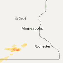
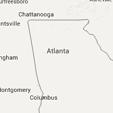
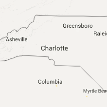
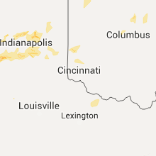
Hail Map for Wednesday, July 13, 2016

Number of Impacted Households on 7/13/2016
0
Impacted by 1" or Larger Hail
0
Impacted by 1.75" or Larger Hail
0
Impacted by 2.5" or Larger Hail
Square Miles of Populated Area Impacted on 7/13/2016
0
Impacted by 1" or Larger Hail
0
Impacted by 1.75" or Larger Hail
0
Impacted by 2.5" or Larger Hail


Cities Most Affected by Hail Storms of 7/13/2016
| Hail Size | Demographics of Zip Codes Affected | ||||||
|---|---|---|---|---|---|---|---|
| City | Count | Average | Largest | Pop Density | House Value | Income | Age |
| Enid, OK | 1 | 2.17 | 2.17 | 256 | $79k | $39.1k | 40.6 |
| Camdenton, MO | 1 | 1.75 | 1.75 | 121 | $105k | $32.0k | 45.1 |
| Panora, IA | 1 | 1.75 | 1.75 | 45 | $113k | $41.6k | 47.7 |
| Terre Haute, IN | 1 | 1.75 | 1.75 | 607 | $81k | $41.2k | 37.1 |
| Geuda Springs, KS | 1 | 1.75 | 1.75 | 5 | $41k | $39.4k | 42.5 |
Hail and Wind Damage Spotted on 7/13/2016
Filter by Report Type:Hail ReportsWind Reports
States Impacted
Iowa, Kansas, Minnesota, Wisconsin, Missouri, Florida, Oklahoma, Virginia, Illinois, Michigan, Indiana, South Carolina, North Carolina, New York, Ohio, Mississippi, Louisiana, Alabama, Texas, Tennessee, Kentucky, PennsylvaniaIowa
| Local Time | Report Details |
|---|---|
| 7:00 AM CDT | Quarter sized hail reported near Sibley, IA, 50.9 miles ESE of Sioux Falls, SD, . |
| 8:00 AM CDT | Quarter sized hail reported near Sioux Center, IA, 42.8 miles SE of Sioux Falls, SD, . |
| 8:15 AM CDT | Storm damage reported in o'brien county IA, 50.5 miles ESE of Sioux Falls, SD |
| 8:26 AM CDT | Quarter sized hail reported near Kingsley, IA, 35.7 miles W of Storm Lake, IA, . |
| 8:44 AM CDT | Ping Pong Ball sized hail reported near Holstein, IA, 25.3 miles WSW of Storm Lake, IA, . |
| 12:35 PM CDT | Trained spotter reports oak tree snapped off at base and other tree damage and branches down in the immediate area. delayed report. time estimated from rada in warren county IA, 27.6 miles S of Des Moines, IA |
| 1:28 PM CDT | Tree damage widespread across town... mostly branches and limbs broken off. numerous areas without power. relayed by mahaska county emergency management. time estimated in mahaska county IA, 54.7 miles ESE of Des Moines, IA |
| 1:29 PM CDT | Trees down. time estimate in mahaska county IA, 54.5 miles ESE of Des Moines, IA |
| 1:31 PM CDT | Semi blown over on glendale rd. time estimate in mahaska county IA, 54.2 miles ESE of Des Moines, IA |
| 1:50 PM CDT | 3 trees down in sigourney. report was delayed. time estiamted using rada in keokuk county IA, 51.7 miles SSW of Cedar Rapids, IA |
| 2:10 PM CDT | Power out in tow in keokuk county IA, 42.2 miles SSW of Cedar Rapids, IA |
| 2:35 PM CDT | Storm damage reported in washington county IA, 46.7 miles S of Cedar Rapids, IA |
| 2:40 PM CDT | Several branches down varying in size from 2 to 18.5 inches along peartree lane. time estimated using rada in muscatine county IA, 49.5 miles SE of Cedar Rapids, IA |
| 2:44 PM CDT | Severe limbs and trees down in town. some of the trees are down on home in louisa county IA, 50.6 miles SSE of Cedar Rapids, IA |
| 2:55 PM CDT | Several small trees snapped and branches blown dow in muscatine county IA, 48.8 miles SE of Cedar Rapids, IA |
| 3:08 PM CDT | 16.5 inch tree branch down near wildcat den state park. time estimated using rada in muscatine county IA, 53.9 miles SE of Cedar Rapids, IA |
| 3:08 PM CDT | 16.5 inch tree branch down near wildcat den state park. time estimated using rada in muscatine county IA, 53.1 miles SE of Cedar Rapids, IA |
| 3:50 PM CDT | Several tree branches are down...some up to 1 foot in diameter near the village of east davenport. tree limbs were blocking the roa in scott county IA, 67.6 miles ESE of Cedar Rapids, IA |
| 3:50 PM CDT | Several small trees snapped and branches blown dow in muscatine county IA, 48.8 miles SE of Cedar Rapids, IA |
| 5:57 PM CDT | Golf Ball sized hail reported near Panora, IA, 36.8 miles W of Des Moines, IA, . |
Kansas
| Local Time | Report Details |
|---|---|
| 7:04 AM CDT | Storm damage reported in lincoln county KS, 56.7 miles ENE of Hays, KS |
| 7:04 AM CDT | Storm damage reported in lincoln county KS, 57.4 miles E of Hays, KS |
| 7:05 AM CDT | Spotter estimates 70 to 75 mph wind in ellsworth county KS, 60.2 miles E of Hays, KS |
| 7:20 AM CDT | Storm damage reported in mitchell county KS, 77.6 miles ENE of Hays, KS |
| 7:26 AM CDT | Twitter report of 65 mph winds. time is estimated from rada in mcpherson county KS, 65.3 miles NNW of Wichita, KS |
| 7:33 AM CDT | Storm damage reported in ottawa county KS, 59.9 miles W of Manhattan, KS |
| 7:50 AM CDT | Storm damage reported in ottawa county KS, 59.9 miles W of Manhattan, KS |
| 7:56 AM CDT | Small limbs down in clay county KS, 41.3 miles W of Manhattan, KS |
| 8:06 AM CDT | Storm damage reported in clay county KS, 38.7 miles W of Manhattan, KS |
| 8:08 AM CDT | Home wind sensor measured 87 mph wind gust around 808 a in clay county KS, 28.1 miles WNW of Manhattan, KS |
| 8:13 AM CDT | Storm damage reported in clay county KS, 28.9 miles WNW of Manhattan, KS |
| 8:32 AM CDT | Multiple outbuildings overturned. a barn was destroyed. a tree fell through a home. numerous trees uprooted. reports were between university park and randolp in riley county KS, 20.3 miles NNW of Manhattan, KS |
| 8:39 AM CDT | The power is out and numerous tree limbs are dow in riley county KS, 16.6 miles WNW of Manhattan, KS |
| 8:40 AM CDT | Report relayed from a citizen in riley county KS, 20.3 miles NNW of Manhattan, KS |
| 8:52 AM CDT | Four inch tree branches down. time estimated from rada in pottawatomie county KS, 13.6 miles E of Manhattan, KS |
| 8:58 AM CDT | Storm damage reported in wabaunsee county KS, 10.4 miles ESE of Manhattan, KS |
| 8:59 AM CDT | Storm damage reported in pottawatomie county KS, 13.6 miles E of Manhattan, KS |
| 9:02 AM CDT | Branches larger that 12 inches in diameter are snapped off of trees. power is also out across the town. barn door was ripped off just north of blain in pottawatomie county KS, 23.8 miles NNE of Manhattan, KS |
| 9:10 AM CDT | Storm damage reported in pottawatomie county KS, 20.7 miles E of Manhattan, KS |
| 9:20 AM CDT | Storm damage reported in nemaha county KS, 43.7 miles NE of Manhattan, KS |
| 9:22 AM CDT | Numerous trees 2 feet in diameter are uproote in pottawatomie county KS, 17.6 miles N of Manhattan, KS |
| 9:28 AM CDT | Tree limbs also coming down in jackson county KS, 44 miles ENE of Manhattan, KS |
| 9:41 AM CDT | Quarter sized hail reported near Berryton, KS, 54.8 miles ESE of Manhattan, KS |
| 10:02 AM CDT | 4 inch diameter limbs snapped at the intersection of 54th and washington rd in jefferson county KS, 36.4 miles W of Kansas City, MO |
| 10:28 AM CDT | Large tree down on seneca st in troy... various tree limbs dow in doniphan county KS, 54.6 miles NNW of Kansas City, MO |
| 10:28 AM CDT | Power lines down... and tree down on va curv in leavenworth county KS, 19.3 miles WNW of Kansas City, MO |
| 10:45 AM CDT | Trees down across count in wyandotte county KS, 16.4 miles WSW of Kansas City, MO |
| 7:24 PM CDT | Quarter sized hail reported near Geuda Springs, KS, 40.5 miles S of Wichita, KS, reported by kake news. some stones a little larger than quarters. |
| 7:24 PM CDT | Golf Ball sized hail reported near Geuda Springs, KS, 40.5 miles S of Wichita, KS, reported by kake news. |
| 8:09 PM CDT | Quarter sized hail reported near Arkansas City, KS, 44 miles SSE of Wichita, KS |
| 8:24 PM CDT | Ping Pong Ball sized hail reported near Geuda Springs, KS, 45.8 miles SSE of Wichita, KS |
| 8:26 PM CDT | Quarter sized hail reported near Arkansas City, KS, 44.7 miles SSE of Wichita, KS |
| 8:47 PM CDT | Ping Pong Ball sized hail reported near Geuda Springs, KS, 44.3 miles S of Wichita, KS |
| 9:48 PM MDT | Quarter sized hail reported near Goodland, KS, 35.9 miles W of Colby, KS, lasted a minute. mostly pea size hail with some nickel size and a few quarter size hail. |
Minnesota
| Local Time | Report Details |
|---|---|
| 7:57 AM CDT | Quarter sized hail reported near Mountain Lake, MN, 74.4 miles SSE of Montevideo, MN, . |
| 8:10 AM CDT | Quarter sized hail reported near Butterfield, MN, 82.4 miles SE of Montevideo, MN, . |
| 8:30 AM CDT | Multiple large trees down in down. power lines to in watonwan county MN, 86 miles SE of Montevideo, MN |
| 8:42 AM CDT | Ping Pong Ball sized hail reported near Lewisville, MN, 83.3 miles NW of Mason City, IA, . |
| 8:44 AM CDT | Quarter sized hail reported near Madelia, MN, 81.7 miles NW of Mason City, IA, crop damage reported west of here too. |
Wisconsin
| Local Time | Report Details |
|---|---|
| 10:30 AM CDT | Quarter sized hail reported near Ridgeland, WI, 72.2 miles E of Minneapolis, MN, . |
| 11:00 AM CDT | Quarter sized hail reported near Hammond, WI, 40.9 miles E of Minneapolis, MN, . |
| 3:25 PM CDT | Quarter sized hail reported near Plymouth, WI, 52 miles S of Green Bay, WI, report relayed via mping. |
| 8:20 PM CDT | Tree branches down. pea sized hail also reported. time estimate in waushara county WI, 75.7 miles WSW of Green Bay, WI |
Missouri
| Local Time | Report Details |
|---|---|
| 10:42 AM CDT | Numerous trees down across cit in buchanan county MO, 47.5 miles NNW of Kansas City, MO |
| 10:55 AM CDT | Wind gust 55-60 mph. east of smithville and west of hol in clay county MO, 25.9 miles NNE of Kansas City, MO |
| 11:10 AM CDT | Large tree down on car in sibley. 4916 n bogar in jackson county MO, 21.3 miles ENE of Kansas City, MO |
| 11:23 AM CDT | Large branches down in lafayette county MO, 27.6 miles E of Kansas City, MO |
| 11:23 AM CDT | Large tree down in jackson county MO, 24.9 miles ESE of Kansas City, MO |
| 11:42 AM CDT | Trees down in roadway across lexingto in lafayette county MO, 38.7 miles E of Kansas City, MO |
| 11:45 AM CDT | Several trees and power lines blown down and minor patio damage to home. this report was from social media. time was estimated by rada in st. clair county MO, 68.6 miles NNW of Springfield, MO |
| 12:10 PM CDT | Several large trees down in cit in carroll county MO, 60.8 miles ENE of Kansas City, MO |
| 12:30 PM CDT | Electric coop website reported up to 10...000 customers without power across the lake of the ozarks regio in camden county MO, 57.5 miles SSW of Columbia, MO |
| 12:35 PM CDT | Several trees snapped and outbuilding damag in cedar county MO, 56.2 miles NW of Springfield, MO |
| 12:55 PM CDT | Delayed report...roof damage to homes and outbuildings from wind and tree limbs. a couple trees fell on to homes. trees and power lines blocking roads. mid-sized transm in randolph county MO, 26.4 miles NNW of Columbia, MO |
| 1:00 PM CDT | Several large trees down in stover. time based on radar estimat in morgan county MO, 50 miles SW of Columbia, MO |
| 1:00 PM CDT | Many large trees 1 to 2 foot diameter down in town. large tree down on top of truc in polk county MO, 43.1 miles NNW of Springfield, MO |
| 1:04 PM CDT | Large tree down and various large limbs from other trees. heavy rai in randolph county MO, 32.6 miles N of Columbia, MO |
| 1:10 PM CDT | 64-feet wide and 250 feet long dock blown onto another dock. time estimate in hickory county MO, 44.9 miles N of Springfield, MO |
| 1:10 PM CDT | Trees down across most of the cit in moniteau county MO, 25.6 miles SSW of Columbia, MO |
| 1:15 PM CDT | A few trees down in tow in moniteau county MO, 14.8 miles SSW of Columbia, MO |
| 1:15 PM CDT | Multiple large tree branches down in the city in moniteau county MO, 25.6 miles SSW of Columbia, MO |
| 1:15 PM CDT | Multiple trees and powerlines down throughout the city in boone county MO, 0.3 miles SE of Columbia, MO |
| 1:15 PM CDT | Numerous trees and power lines dow in randolph county MO, 32.8 miles N of Columbia, MO |
| 1:20 PM CDT | Several trees were uprooted near urban in dallas county MO, 44 miles N of Springfield, MO |
| 1:25 PM CDT | Trampoline trown into a tree and destroyed. picture from social media. time was estimated by rada in dallas county MO, 46.5 miles NNE of Springfield, MO |
| 1:27 PM CDT | Three-inch diameter tree limb down. time estimate in camden county MO, 59.3 miles NNE of Springfield, MO |
| 1:30 PM CDT | Trees down accross mo hwy 15 and us 2 in monroe county MO, 40.6 miles NNE of Columbia, MO |
| 1:40 PM CDT | 8 to 12 inch tree uprooted at hwy 5 and hwy 54. power out from old hwy5 to new hwy 5. time estimated based on rada in camden county MO, 63.9 miles NNE of Springfield, MO |
| 1:40 PM CDT | Tree down into power line in callaway county MO, 21.9 miles ESE of Columbia, MO |
| 1:45 PM CDT | Quarter sized hail reported near Camdenton, MO, 63 miles NNE of Springfield, MO, dime to quarter size hail on bear paw road. |
| 1:45 PM CDT | Estimated 50-60 mp in callaway county MO, 21.9 miles ESE of Columbia, MO |
| 1:45 PM CDT | Roof and structural damage reporte in monroe county MO, 53.9 miles NNE of Columbia, MO |
| 1:46 PM CDT | Tree damage in the cit in monroe county MO, 53.2 miles S of Kahoka, MO |
| 1:47 PM CDT | Storm damage reported in monroe county MO, 53.9 miles S of Kahoka, MO |
| 1:50 PM CDT | Storm damage reported in cole county MO, 27.5 miles SSE of Columbia, MO |
| 1:50 PM CDT | Snapped power poles...trees and power lines down in ralls county MO, 48.6 miles NE of Columbia, MO |
| 1:51 PM CDT | Storm damage reported in callaway county MO, 32.7 miles E of Columbia, MO |
| 2:00 PM CDT | Numerous large trees and power lines were blown down around ulman and across miller county. video was on social medi in miller county MO, 55.6 miles S of Columbia, MO |
| 2:00 PM CDT | Trees and power lines down in ralls county MO, 57.8 miles NE of Columbia, MO |
| 2:05 PM CDT | Trees and power lines down in ralls county MO, 60.4 miles SSE of Kahoka, MO |
| 2:05 PM CDT | 63 mph wind gus in pulaski county MO, 49.8 miles WNW of Salem, MO |
| 2:10 PM CDT | Estimated 55-60 mph in pike county MO, 69.6 miles ENE of Columbia, MO |
| 2:10 PM CDT | Trees and limbs down...concentrated in south part of the city in marion county MO, 52.2 miles SSE of Kahoka, MO |
| 2:11 PM CDT | Storm damage reported in montgomery county MO, 44.4 miles E of Columbia, MO |
| 2:15 PM CDT | Several trees were blown down around st. robert in pulaski county MO, 37.7 miles WNW of Salem, MO |
| 2:15 PM CDT | Numerous large limbs blown down in the waynesville area. there was damage to a fence and minor damage to a home. picture was on social medi in pulaski county MO, 38.8 miles WNW of Salem, MO |
| 2:17 PM CDT | Trees down on route 89 in osage county MO, 48.4 miles NNW of Salem, MO |
| 2:20 PM CDT | Transmitter down in montgomery county MO, 53.1 miles E of Columbia, MO |
| 2:20 PM CDT | Asos reported wind gust of 61 mp in maries county MO, 36.3 miles NNW of Salem, MO |
| 2:24 PM CDT | 4 inch diameter tree limbs down in gasconade county MO, 49.2 miles N of Salem, MO |
| 2:25 PM CDT | Winds estimated up to 70 mph. heavy rain 1.50 to 1.74 inches in 30 minute in phelps county MO, 24.3 miles NW of Salem, MO |
| 2:30 PM CDT | Large tree and limbs down greater than 2 inches. 0.75 inch hail als in pulaski county MO, 36.7 miles WNW of Salem, MO |
| 2:30 PM CDT | Numerous large tree and power lines blown down across the county. a few trees were blown onto cars. one tree was blown on to a house causing structural damag in phelps county MO, 25.1 miles NNW of Salem, MO |
| 2:35 PM CDT | Numerous trees and several power lines blown down. picture from social media. time was estimated by rada in phelps county MO, 19.5 miles NW of Salem, MO |
| 2:37 PM CDT | Storm damage reported in lincoln county MO, 47.7 miles WNW of Saint Louis, MO |
| 2:40 PM CDT | Trees and power lines down in crawford county MO, 30.1 miles NNE of Salem, MO |
| 2:40 PM CDT | Trees down in lincoln county MO, 49 miles WNW of Saint Louis, MO |
| 2:45 PM CDT | Trees down in warren county MO, 45.4 miles WNW of Saint Louis, MO |
| 2:45 PM CDT | Trees and power lines down in crawford county MO, 38.7 miles NNE of Salem, MO |
| 2:45 PM CDT | Trees and power lines down in crawford county MO, 24.9 miles NNE of Salem, MO |
| 2:49 PM CDT | Trees and powerlines down in crawford county MO, 30.1 miles NNE of Salem, MO |
| 2:50 PM CDT | Storm damage reported in lincoln county MO, 44.8 miles WNW of Saint Louis, MO |
| 2:50 PM CDT | 8limbs down in lincoln county MO, 48.6 miles WNW of Saint Louis, MO |
| 2:50 PM CDT | 8limbs down in lincoln county MO, 48.6 miles WNW of Saint Louis, MO |
| 2:50 PM CDT | Downed power lines and large tree limbs down across the count in phelps county MO, 25.1 miles NNW of Salem, MO |
| 2:54 PM CDT | Storm damage reported in franklin county MO, 46.4 miles WSW of Saint Louis, MO |
| 2:55 PM CDT | Quarter sized hail reported near O Fallon, MO, 29.5 miles WNW of Saint Louis, MO, quarter-sized hail and limbs down at highway k and i-70 in ofallon missouri. |
| 2:55 PM CDT | Trees and power lines down in crawford county MO, 20.3 miles NE of Salem, MO |
| 2:55 PM CDT | Trees and power lines down in franklin county MO, 45.6 miles WSW of Saint Louis, MO |
| 3:00 PM CDT | Trees and power lines down in franklin county MO, 46.4 miles WSW of Saint Louis, MO |
| 3:05 PM CDT | Shingle damage to roo in franklin county MO, 45.6 miles WSW of Saint Louis, MO |
| 3:07 PM CDT | Storm damage reported in st. charles county MO, 29.7 miles WNW of Saint Louis, MO |
| 3:07 PM CDT | Storm damage reported in st. charles county MO, 29.2 miles WNW of Saint Louis, MO |
| 3:10 PM CDT | Large trees down in st. charles county MO, 24.5 miles WNW of Saint Louis, MO |
| 3:10 PM CDT | Large trees down in washington county MO, 41.1 miles ENE of Salem, MO |
| 3:10 PM CDT | Large tree limb broke in st. charles county MO, 25.8 miles WNW of Saint Louis, MO |
| 3:10 PM CDT | Several trees and limbs down in franklin county MO, 31.5 miles WSW of Saint Louis, MO |
| 3:10 PM CDT | Trees and limbs down in franklin county MO, 34.6 miles WSW of Saint Louis, MO |
| 3:13 PM CDT | 60 mph estimate with numerous limbs dow in franklin county MO, 34.6 miles WSW of Saint Louis, MO |
| 3:15 PM CDT | Widespread trees and powerlines down in iron county MO, 23 miles ENE of Salem, MO |
| 3:15 PM CDT | Large tree limbs down in franklin county MO, 40.6 miles WSW of Saint Louis, MO |
| 3:15 PM CDT | Trash cans blown into street. trampoline blown across street. decorative shutter blown of in st. charles county MO, 25.2 miles WNW of Saint Louis, MO |
| 3:15 PM CDT | Trees and limbs down in st. charles county MO, 20.6 miles WNW of Saint Louis, MO |
| 3:20 PM CDT | Trees...tree limbs...and power lines down in st. louis county MO, 19.1 miles W of Saint Louis, MO |
| 3:20 PM CDT | Trees and limbs down in st. louis county MO, 21.3 miles W of Saint Louis, MO |
| 3:25 PM CDT | Powerlines down in st. louis county MO, 19.1 miles W of Saint Louis, MO |
| 3:25 PM CDT | 6 tree limbs down in jefferson county MO, 38.9 miles SSW of Saint Louis, MO |
| 3:27 PM CDT | Multiple trees and powerlines down in franklin county MO, 45.6 miles WSW of Saint Louis, MO |
| 3:27 PM CDT | Trees and power lines down in st. francois county MO, 52.4 miles SSW of Saint Louis, MO |
| 3:28 PM CDT | Winds between 50 and 60 mph at 5th street and i-70 in st. charles. numerous small limbs dow in st. charles county MO, 20.6 miles WNW of Saint Louis, MO |
| 3:30 PM CDT | Widespread trees and power lines down in iron county MO, 43.2 miles E of Salem, MO |
| 3:30 PM CDT | Large trees down...one fell on a home in st. louis county MO, 12.4 miles WSW of Saint Louis, MO |
| 3:30 PM CDT | Trees and power lines down in st. francois county MO, 55.1 miles SSW of Saint Louis, MO |
| 3:31 PM CDT | Storm damage reported in jefferson county MO, 33.2 miles SW of Saint Louis, MO |
| 3:32 PM CDT | Roof damage to pasta house company in jefferson county MO, 16.5 miles SW of Saint Louis, MO |
| 3:32 PM CDT | Trees and limbs down in jefferson county MO, 21.3 miles WSW of Saint Louis, MO |
| 3:32 PM CDT | Trees...tree limbs...and power lines down in st. louis county MO, 8.6 miles WSW of Saint Louis, MO |
| 3:33 PM CDT | Storm damage reported in st. louis county MO, 13.4 miles WSW of Saint Louis, MO |
| 3:34 PM CDT | Multiple trees down in washington county MO, 49.5 miles ENE of Salem, MO |
| 3:35 PM CDT | Tree down and water over road in st. charles county MO, 33.5 miles WNW of Saint Louis, MO |
| 3:35 PM CDT | Small branches down in st. louis county MO, 14.3 miles SW of Saint Louis, MO |
| 3:35 PM CDT | Trees down in st. louis county MO, 7.5 miles WSW of Saint Louis, MO |
| 3:35 PM CDT | Trees and limbs down in st. louis county MO, 15.9 miles NW of Saint Louis, MO |
| 3:38 PM CDT | 30 to 40 trees knocked down at jefferson barricks cemetery in st. louis county MO, 7.7 miles SSW of Saint Louis, MO |
| 3:39 PM CDT | Trees and branches down up to 10. power lines down in st. louis county MO, 8 miles SSW of Saint Louis, MO |
| 3:39 PM CDT | Vehicle windows blown out... portions of a bus stop shelter blown away. large tree and power line dow in st. louis county MO, 7.7 miles SSW of Saint Louis, MO |
| 3:40 PM CDT | 6 inch branches down in st. louis city county MO, 2.3 miles WNW of Saint Louis, MO |
| 3:40 PM CDT | Trees and limbs down in st. louis county MO, 7.2 miles NNW of Saint Louis, MO |
| 3:40 PM CDT | Large tree limbs down across town. several power lines down. several roadways blocke in st. francois county MO, 58.7 miles NW of Cape Girardeau, MO |
| 3:41 PM CDT | Numerous trees and powerlines down throughout the county in st. francois county MO, 58.7 miles NW of Cape Girardeau, MO |
| 3:42 PM CDT | Trees and power lines down in ste. genevieve county MO, 42.6 miles S of Saint Louis, MO |
| 3:42 PM CDT | Trees and power lines down in st. francois county MO, 58.7 miles NW of Cape Girardeau, MO |
| 3:43 PM CDT | Trees down in forest park near zo in st. louis city county MO, 2.3 miles WNW of Saint Louis, MO |
| 3:45 PM CDT | Large tree limbs and power lines down in jefferson county MO, 25.7 miles SSW of Saint Louis, MO |
| 3:45 PM CDT | 10 limbs down near lindell and kingshighway in st. louis city county MO, 2.3 miles WNW of Saint Louis, MO |
| 3:45 PM CDT | Trees and power lines down in ste. genevieve county MO, 51.6 miles S of Saint Louis, MO |
| 3:45 PM CDT | Several trees partially or fully uproote in st. louis county MO, 12.7 miles SW of Saint Louis, MO |
| 3:45 PM CDT | Numerous trees...tree limbs and power lines throughout the south part of the city in st. louis city county MO, 4 miles SSW of Saint Louis, MO |
| 3:45 PM CDT | Power pole snapped and trees down in soulard in st. louis city county MO, 5.2 miles SSW of Saint Louis, MO |
| 3:50 PM CDT | Trees and power lines down in ste. genevieve county MO, 46.1 miles S of Saint Louis, MO |
| 3:53 PM CDT | *** 1 inj *** folding table hit victim in head. no serious injuries. traffic cones and canopy tents blown over as wel in st. louis county MO, 16.4 miles WNW of Saint Louis, MO |
| 4:00 PM CDT | Three reports of trees on structures in jefferson county MO, 38.9 miles SSW of Saint Louis, MO |
| 4:00 PM CDT | Two reports of trees on structure near valle mines in st. francois county MO, 47.3 miles SSW of Saint Louis, MO |
| 4:02 PM CDT | Vehicle windows blown out... portion of bus stop shelter blown away... large tree limbs down at jefferson barrack in st. louis county MO, 13.3 miles SSW of Saint Louis, MO |
| 4:10 PM CDT | 5 tree limbs down in st. louis county MO, 14.5 miles SSW of Saint Louis, MO |
| 4:10 PM CDT | One tree over the road on cr832 and one tree down on cr210 in perry county MO, 38.7 miles NNW of Cape Girardeau, MO |
| 4:11 PM CDT | Large tree limbs down throughout tower grove park in st. louis city county MO, 2.3 miles WNW of Saint Louis, MO |
| 4:15 PM CDT | 4 tree limbs down in st. louis county MO, 7.1 miles W of Saint Louis, MO |
| 4:15 PM CDT | Large tree covering road in st. francois county MO, 56.6 miles SSW of Saint Louis, MO |
| 4:20 PM CDT | 1 ft diameter tree down in st. louis county MO, 8 miles SSW of Saint Louis, MO |
| 4:25 PM CDT | Tree limbs down at clayton and warson in st. louis county MO, 9.8 miles W of Saint Louis, MO |
| 4:30 PM CDT | Tree on power line in caledonia in washington county MO, 43.1 miles ENE of Salem, MO |
| 7:45 PM CDT | Ping Pong Ball sized hail reported near Richland, MO, 49.8 miles WNW of Salem, MO, picture from social media. time was estimated by radar. |
| 8:10 PM CDT | Golf Ball sized hail reported near Camdenton, MO, 63 miles NNE of Springfield, MO |
| 8:39 PM CDT | Quarter sized hail reported near Camdenton, MO, 63.6 miles NNE of Springfield, MO, quarter size hail reported just north of camdenton |
| 9:55 PM CDT | Reports of large trees and branches down. size unknown at this time. time estimated based on rada in camden county MO, 57.6 miles WNW of Salem, MO |
| 3:45 AM CDT | Outflow ahead of thunderstorms downed power lines in the gainseville are in ozark county MO, 63.6 miles SE of Springfield, MO |
Florida
| Local Time | Report Details |
|---|---|
| 1:10 PM CDT | 2 trees down on hwy 81 n in ponce de leo in holmes county FL, 35 miles NE of Miramar Beach, FL |
| 4:10 PM EDT | Mount dora police department reports numerous trees and powerlines down across the city of mount dora. time estimated by rada in lake county FL, 24.6 miles NW of Orlando, FL |
| 7:50 PM EDT | The emergency manager reported trees and powerlines down near county road 231 south of lake butler. the time given was based on rada in union county FL, 49.7 miles WSW of Jacksonville, FL |
Oklahoma
| Local Time | Report Details |
|---|---|
| 1:55 PM CDT | Storm damage reported in craig county OK, 62.3 miles SSE of Chanute, KS |
| 11:10 PM CDT | Storm damage reported in garfield county OK, 65.4 miles N of Oklahoma City, OK |
| 11:15 PM CDT | Enid woodring airport in garfield county OK, 63.6 miles NNW of Oklahoma City, OK |
| 11:15 PM CDT | Storm damage reported in garfield county OK, 65.4 miles N of Oklahoma City, OK |
| 11:42 PM CDT | Hen Egg sized hail reported near Enid, OK, 77.7 miles E of Woodward, OK |
| 11:45 PM CDT | Quarter sized hail reported near Garber, OK, 64 miles N of Oklahoma City, OK |
| 12:01 AM CDT | Quarter sized hail reported near Enid, OK, 68.7 miles NNW of Oklahoma City, OK |
| 12:05 AM CDT | Storm damage reported in payne county OK, 52.4 miles NNE of Oklahoma City, OK |
| 12:08 AM CDT | Storm damage reported in payne county OK, 52.4 miles NNE of Oklahoma City, OK |
| 12:10 AM CDT | Quarter sized hail reported near Enid, OK, 67.1 miles NNW of Oklahoma City, OK |
| 12:10 AM CDT | Storm damage reported in payne county OK, 54 miles NNE of Oklahoma City, OK |
| 12:11 AM CDT | Storm damage reported in payne county OK, 52.4 miles NNE of Oklahoma City, OK |
| 12:35 AM CDT | Power line downed and a semi turned over at highways 33 and 17 in payne county OK, 44 miles NE of Oklahoma City, OK |
| 1:46 AM CDT | Few trees snapped and limbs down near 71st and mingo in tulsa county OK, 4.3 miles ESE of Tulsa, OK |
| 1:50 AM CDT | Storm damage reported in okmulgee county OK, 21.6 miles S of Tulsa, OK |
| 1:50 AM CDT | Storm damage reported in tulsa county OK, 15.4 miles SSE of Tulsa, OK |
| 2:35 AM CDT | Storm damage reported in mcintosh county OK, 52.8 miles SSE of Tulsa, OK |
| 3:30 AM CDT | Storm damage reported in latimer county OK, 59.4 miles NE of Atoka, OK |
Virginia
| Local Time | Report Details |
|---|---|
| 3:18 PM EDT | One tree down over smith mt lake pkwy. time radar estimate in bedford county VA, 23 miles ESE of Roanoke, VA |
| 3:26 PM EDT | Tree fell across powerlin in pittsylvania county VA, 25.5 miles SE of Roanoke, VA |
| 4:06 PM EDT | One tree down along the 501 expy in city of lynchburg county VA, 40.8 miles E of Roanoke, VA |
| 4:12 PM EDT | One tree down on an attached garage. no major damage. time radar estimate in city of lynchburg county VA, 41.5 miles E of Roanoke, VA |
| 4:14 PM EDT | 3 trees down along sandy creek roa in pittsylvania county VA, 49 miles SSE of Roanoke, VA |
| 4:18 PM EDT | Metal roof blown off of a business on riverside dr. reported on by multiple sources. time radar estimate in city of danville county VA, 54.3 miles SSE of Roanoke, VA |
| 4:25 PM EDT | Canopy blown over at a gas station near averett university. reported by wdbj7. time radar estimate in city of danville county VA, 56 miles SSE of Roanoke, VA |
Illinois
| Local Time | Report Details |
|---|---|
| 2:25 PM CDT | Trees down in pike county IL, 56.3 miles SSE of Kahoka, MO |
| 2:25 PM CDT | Numerous trees down in the south and southeast sections of the city in adams county IL, 38.1 miles SSE of Kahoka, MO |
| 2:35 PM CDT | 8 diameter limbs down in adams county IL, 40 miles SE of Kahoka, MO |
| 2:48 PM CDT | Trees down on county road 100 and 96 in pike county IL, 64.9 miles NNW of Saint Louis, MO |
| 2:50 PM CDT | Power lines down and on fire in calhoun county IL, 58.8 miles NNW of Saint Louis, MO |
| 2:55 PM CDT | Storm damage reported in pike county IL, 64.4 miles NNW of Saint Louis, MO |
| 3:05 PM CDT | Trees down in calhoun county IL, 43.2 miles NNW of Saint Louis, MO |
| 3:06 PM CDT | Trees down on hwy 100 in pike county IL, 66.1 miles NNW of Saint Louis, MO |
| 3:09 PM CDT | Trees down across il route 10 in scott county IL, 75.4 miles NNW of Saint Louis, MO |
| 3:10 PM CDT | Tree on house. southeast side of quincy in adams county IL, 38.1 miles SSE of Kahoka, MO |
| 3:15 PM CDT | Trees down in calhoun county IL, 30.6 miles NW of Saint Louis, MO |
| 3:21 PM CDT | Trees down on route 100 in jersey county IL, 26.7 miles NNW of Saint Louis, MO |
| 3:25 PM CDT | Trees down in dow in jersey county IL, 25.8 miles NNW of Saint Louis, MO |
| 3:26 PM CDT | Trees coming down in aled in mercer county IL, 70.2 miles WNW of Peoria, IL |
| 3:26 PM CDT | Several 5 inch diameter trees dow in mcdonough county IL, 54.3 miles E of Kahoka, MO |
| 3:30 PM CDT | Furniture blown around and semi trailer blown over at the mercer county fair in aledo. winds of 60 mp in mercer county IL, 70.2 miles WNW of Peoria, IL |
| 3:33 PM CDT | Large power pole snapped half way up near 106th ave and us 67...report via facebook. time estimated from rada in rock island county IL, 69.2 miles SE of Cedar Rapids, IA |
| 3:34 PM CDT | Large branches down across the road 1 mile north of lake warre in warren county IL, 60.1 miles WNW of Peoria, IL |
| 3:35 PM CDT | Large branch blown down. time estimate in rock island county IL, 66.1 miles ESE of Cedar Rapids, IA |
| 3:40 PM CDT | Storm damage reported in rock island county IL, 70.7 miles ESE of Cedar Rapids, IA |
| 3:40 PM CDT | Trees and power lines down in monroe county IL, 11.7 miles S of Saint Louis, MO |
| 3:42 PM CDT | Trees and power lines down in monroe county IL, 20.6 miles S of Saint Louis, MO |
| 3:42 PM CDT | Trees and limbs down in st. clair county IL, 7.5 miles S of Saint Louis, MO |
| 3:45 PM CDT | Trees dow in henry county IL, 61.1 miles NW of Peoria, IL |
| 3:45 PM CDT | Trees toppled and damage to barn roof in monroe county IL, 20.6 miles S of Saint Louis, MO |
| 3:45 PM CDT | Tree snapped near base. report obtained from social medi in knox county IL, 52.2 miles NW of Peoria, IL |
| 3:45 PM CDT | Large oak tree uprooted...crossing summit ave north between main and william in cass county IL, 60.8 miles SSW of Peoria, IL |
| 3:45 PM CDT | Roof ripped off structure in st. clair county IL, 6.4 miles SSW of Saint Louis, MO |
| 3:45 PM CDT | Trees and limbs down in madison county IL, 19 miles N of Saint Louis, MO |
| 3:45 PM CDT | Trees and power lines down in st. clair county IL, 6.3 miles ESE of Saint Louis, MO |
| 3:45 PM CDT | Trees and power lines down in madison county IL, 6.8 miles NNE of Saint Louis, MO |
| 3:47 PM CDT | Storm damage reported in rock island county IL, 70.7 miles ESE of Cedar Rapids, IA |
| 3:48 PM CDT | Power lines down in macoupin county IL, 60 miles N of Saint Louis, MO |
| 3:50 PM CDT | Power lines down in macoupin county IL, 51.2 miles N of Saint Louis, MO |
| 3:50 PM CDT | Trees down at il 161 and north belt west in st. clair county IL, 12.7 miles ESE of Saint Louis, MO |
| 3:50 PM CDT | Damage to garage. siding and portion of upper wall blown off in st. clair county IL, 12.9 miles ESE of Saint Louis, MO |
| 3:50 PM CDT | Numerous tree branches were blown down around tow in henry county IL, 67.9 miles NW of Peoria, IL |
| 3:51 PM CDT | Trees down ... shingles ripped off roofs and damaging to sidin in st. clair county IL, 20.8 miles SE of Saint Louis, MO |
| 3:52 PM CDT | Trees and power lines down in st. clair county IL, 12.7 miles ESE of Saint Louis, MO |
| 3:52 PM CDT | Trees and power lines down in randolph county IL, 30.8 miles SSE of Saint Louis, MO |
| 3:53 PM CDT | 10 tree down in madison county IL, 11.8 miles NNE of Saint Louis, MO |
| 3:54 PM CDT | Trees and power lines down in madison county IL, 17.2 miles NE of Saint Louis, MO |
| 3:55 PM CDT | Bussiness sign damaged near convention center in madison county IL, 11.4 miles ENE of Saint Louis, MO |
| 3:55 PM CDT | Large trees down in macoupin county IL, 44.2 miles N of Saint Louis, MO |
| 3:55 PM CDT | Numerous power lines throughout the county in randolph county IL, 45.4 miles NNW of Cape Girardeau, MO |
| 3:55 PM CDT | A couple of branches down 3 to 4 inches in diameter in henry county IL, 67.9 miles NW of Peoria, IL |
| 3:57 PM CDT | Trees and limbs down in st. clair county IL, 20.8 miles SE of Saint Louis, MO |
| 3:58 PM CDT | Storm damage reported in madison county IL, 18.2 miles ENE of Saint Louis, MO |
| 3:58 PM CDT | Large limbs down in randolph county IL, 30.8 miles SSE of Saint Louis, MO |
| 4:00 PM CDT | Large branch blown dow in rock island county IL, 67.2 miles ESE of Cedar Rapids, IA |
| 4:00 PM CDT | Pole poles snapped in madison county IL, 24.9 miles ENE of Saint Louis, MO |
| 4:00 PM CDT | Trees dow in henry county IL, 60 miles NNW of Peoria, IL |
| 4:00 PM CDT | Trees and power lines down in macoupin county IL, 48.2 miles NNE of Saint Louis, MO |
| 4:00 PM CDT | 10 diameter tree down in st. clair county IL, 19.9 miles ESE of Saint Louis, MO |
| 4:00 PM CDT | Trees down in st. clair county IL, 21.2 miles E of Saint Louis, MO |
| 4:00 PM CDT | Trees and power lines down in randolph county IL, 36.5 miles SSE of Saint Louis, MO |
| 4:00 PM CDT | Storm damage reported in st. clair county IL, 19.7 miles ESE of Saint Louis, MO |
| 4:02 PM CDT | Few trees and limbs down in st. clair county IL, 22.6 miles ESE of Saint Louis, MO |
| 4:03 PM CDT | 6 limbs down in madison county IL, 14.7 miles ENE of Saint Louis, MO |
| 4:03 PM CDT | Trees dow in henry county IL, 40.6 miles NW of Peoria, IL |
| 4:04 PM CDT | Trees and limbs down in madison county IL, 28.5 miles NE of Saint Louis, MO |
| 4:05 PM CDT | Trees and power lines down in randolph county IL, 42 miles SE of Saint Louis, MO |
| 4:05 PM CDT | Several large tree limbs and branches down in jackson county IL, 33.9 miles NNE of Cape Girardeau, MO |
| 4:06 PM CDT | Trees dow in henry county IL, 40.6 miles NNW of Peoria, IL |
| 4:06 PM CDT | Trees and power lines down in randolph county IL, 45.4 miles NNW of Cape Girardeau, MO |
| 4:06 PM CDT | Trees and limbs down in madison county IL, 31.2 miles NE of Saint Louis, MO |
| 4:07 PM CDT | Trees and limbs down in clinton county IL, 28.1 miles E of Saint Louis, MO |
| 4:08 PM CDT | 8 inch diameter tree snapped at the base at 11 buckingham driv in sangamon county IL, 70.8 miles S of Peoria, IL |
| 4:10 PM CDT | Trees and power lines down in clinton county IL, 27.7 miles ESE of Saint Louis, MO |
| 4:10 PM CDT | Trees and power lines down in madison county IL, 29.1 miles ENE of Saint Louis, MO |
| 4:10 PM CDT | Trees and power lines down in st. clair county IL, 35.2 miles SE of Saint Louis, MO |
| 4:10 PM CDT | One stall garage destroyed. one 50 x 70 foot building thrown on top of another 50 x 70 foot buildin in peoria county IL, 20.2 miles W of Peoria, IL |
| 4:12 PM CDT | Large tree limbs down in madison county IL, 29.1 miles ENE of Saint Louis, MO |
| 4:12 PM CDT | Trees and power lines down in randolph county IL, 49.2 miles N of Cape Girardeau, MO |
| 4:13 PM CDT | Trees and power lines down in clinton county IL, 32.4 miles ESE of Saint Louis, MO |
| 4:13 PM CDT | Trees and power lines down in washington county IL, 38.7 miles SE of Saint Louis, MO |
| 4:14 PM CDT | Trees blocking road near venedy station...one half mile south of highway 160 17 in washington county IL, 35.2 miles ESE of Saint Louis, MO |
| 4:15 PM CDT | Measured on davis vantage in madison county IL, 18.2 miles ENE of Saint Louis, MO |
| 4:15 PM CDT | Storm damage reported in randolph county IL, 43 miles SE of Saint Louis, MO |
| 4:15 PM CDT | 3 tree limbs 8 inches in diameter and an additional 3 limbs 3 to 5 inches in diameter down along highway 16 in madison county IL, 28.5 miles E of Saint Louis, MO |
| 4:15 PM CDT | One large tree...one foot in diameter...and several 6-8 inch in diameter branches dow in madison county IL, 28.3 miles E of Saint Louis, MO |
| 4:15 PM CDT | Large tree limbs/branches down in peoria county IL, 25.2 miles NW of Peoria, IL |
| 4:16 PM CDT | Trees and power lines down in washington county IL, 37.7 miles ESE of Saint Louis, MO |
| 4:18 PM CDT | Trees and power lines down in clinton county IL, 36.8 miles E of Saint Louis, MO |
| 4:18 PM CDT | Trees and power lines down in clinton county IL, 35.3 miles E of Saint Louis, MO |
| 4:18 PM CDT | 2 trees down...3 foot diameter at route 78 and lawrence in peoria county IL, 3.5 miles NNW of Peoria, IL |
| 4:19 PM CDT | Trees and power lines down in washington county IL, 41.8 miles ESE of Saint Louis, MO |
| 4:20 PM CDT | Trees and power lines down in clinton county IL, 40 miles E of Saint Louis, MO |
| 4:20 PM CDT | Tree on a house and two car in perry county IL, 54.4 miles N of Cape Girardeau, MO |
| 4:20 PM CDT | Trees and power lines down in bond county IL, 38 miles ENE of Saint Louis, MO |
| 4:20 PM CDT | 8 - 10 tree limbs down in washington county IL, 48.4 miles ESE of Saint Louis, MO |
| 4:20 PM CDT | Trees and power lines dow in montgomery county IL, 59.7 miles NNE of Saint Louis, MO |
| 4:21 PM CDT | Numerous trees down around the city in madison county IL, 29.1 miles ENE of Saint Louis, MO |
| 4:21 PM CDT | One large tree...one foot in diameter...and several 6-8 inch in diameter branches dow in madison county IL, 28.3 miles E of Saint Louis, MO |
| 4:23 PM CDT | Numerous small tree limbs down in sangamon county IL, 63 miles S of Peoria, IL |
| 4:24 PM CDT | Shingles blown off roof and multiple trees dow in clinton county IL, 44.9 miles E of Saint Louis, MO |
| 4:24 PM CDT | Numerous trees... limbs and power lines down throughout montgomery count in montgomery county IL, 47.9 miles NE of Saint Louis, MO |
| 4:24 PM CDT | Damage to two gin bins and shed completely gone in montgomery county IL, 48.2 miles NE of Saint Louis, MO |
| 4:25 PM CDT | Several trees down in the city limits in perry county IL, 50.9 miles NNE of Cape Girardeau, MO |
| 4:25 PM CDT | Trees and power lines down in bond county IL, 46.8 miles ENE of Saint Louis, MO |
| 4:25 PM CDT | Trees and power lines down in clinton county IL, 44.9 miles E of Saint Louis, MO |
| 4:25 PM CDT | Trees and power lines down in washington county IL, 48.4 miles ESE of Saint Louis, MO |
| 4:28 PM CDT | Large tree limbs down. amateur radio antenna ben in bond county IL, 46.8 miles ENE of Saint Louis, MO |
| 4:28 PM CDT | Trees and power lines dow in montgomery county IL, 54.1 miles NE of Saint Louis, MO |
| 4:30 PM CDT | Trees and p0wer lines dow in montgomery county IL, 53.4 miles NE of Saint Louis, MO |
| 4:30 PM CDT | Route 154 and pintail road blocked by trees and power lines dow in perry county IL, 56.8 miles NNE of Cape Girardeau, MO |
| 4:30 PM CDT | Est 50 to 60 mph gusts with shingle damage and small limbs dow in washington county IL, 51.8 miles ESE of Saint Louis, MO |
| 4:30 PM CDT | Several trees dow in perry county IL, 60.3 miles NNE of Cape Girardeau, MO |
| 4:31 PM CDT | Trees and power lines down. four people trapped in a vehicle. hwy 154 2 miles east hwy 5 in perry county IL, 56.4 miles NNE of Cape Girardeau, MO |
| 4:35 PM CDT | State highway 154 is closed at the perry...franklin county line due to fallen trees and power lines. relayed through wsil channel in perry county IL, 59.1 miles NNE of Cape Girardeau, MO |
| 4:36 PM CDT | Trees toppled and damage to barn roof in monroe county IL, 20.6 miles S of Saint Louis, MO |
| 4:36 PM CDT | Trees and power lines down in washington county IL, 57.8 miles ESE of Saint Louis, MO |
| 4:38 PM CDT | Trees... power lines and power poles dow in marion county IL, 58.4 miles E of Saint Louis, MO |
| 4:40 PM CDT | 3 inch diameter limbs down in jacob i in jackson county IL, 32.2 miles N of Cape Girardeau, MO |
| 4:40 PM CDT | Trees down in clinton county IL, 44.9 miles E of Saint Louis, MO |
| 4:40 PM CDT | Numerous trees and power lines dow in marion county IL, 58.4 miles E of Saint Louis, MO |
| 4:40 PM CDT | 12 inch tree limbs down in christian county IL, 55.5 miles WNW of Mattoon, IL |
| 4:40 PM CDT | Power lines and numerous trees down. report of tree on house in bond county IL, 46.8 miles ENE of Saint Louis, MO |
| 4:42 PM CDT | Trees... power lines... and a couple of power poles dow in marion county IL, 62.2 miles E of Saint Louis, MO |
| 4:43 PM CDT | Trees and power lines down in bond county IL, 54.1 miles ENE of Saint Louis, MO |
| 4:43 PM CDT | Trees and power lines down in fayette county IL, 45.9 miles WSW of Mattoon, IL |
| 4:43 PM CDT | Trees and power lines down in fayette county IL, 52 miles SW of Mattoon, IL |
| 4:44 PM CDT | Storm damage reported in jefferson county IL, 65.9 miles NNE of Cape Girardeau, MO |
| 4:45 PM CDT | Trees down on us hwy 51. time estimated from radar in fayette county IL, 52 miles SW of Mattoon, IL |
| 4:45 PM CDT | 1.5 foot diameter tree snapped in tazewell county IL, 5 miles S of Peoria, IL |
| 4:45 PM CDT | Tree on a house reported from wsil channel in jackson county IL, 33.9 miles NNE of Cape Girardeau, MO |
| 4:45 PM CDT | Damage to trees and metal roof of mobile hom in bond county IL, 54.1 miles ENE of Saint Louis, MO |
| 4:45 PM CDT | 3 inch diamter limb dow in bureau county IL, 47.9 miles N of Peoria, IL |
| 4:45 PM CDT | Storm damage reported in peoria county IL, 3.5 miles NNW of Peoria, IL |
| 4:45 PM CDT | Storm damage reported in peoria county IL, 3.5 miles NNW of Peoria, IL |
| 4:47 PM CDT | Tree down across route 3 in franklin county IL, 66.5 miles NNE of Cape Girardeau, MO |
| 4:49 PM CDT | Several trees down throughout the community. large branches were also snappe in franklin county IL, 59.6 miles NE of Cape Girardeau, MO |
| 4:49 PM CDT | Roof torn off mobile home. relayed through wsil channel in franklin county IL, 66.3 miles NE of Cape Girardeau, MO |
| 4:49 PM CDT | Several large tree limbs dow in knox county IL, 38.4 miles NW of Peoria, IL |
| 4:50 PM CDT | Trees... power lines... and power poles dow in marion county IL, 66.4 miles SSW of Mattoon, IL |
| 4:50 PM CDT | Trees down blocking england roa in marion county IL, 67.6 miles E of Saint Louis, MO |
| 4:50 PM CDT | Trees and power lines down in fayette county IL, 45.3 miles SW of Mattoon, IL |
| 4:50 PM CDT | Large tree down and tree limb in jackson county IL, 33.9 miles NNE of Cape Girardeau, MO |
| 4:50 PM CDT | Large tree down along with numerous limb in franklin county IL, 60.7 miles NNE of Cape Girardeau, MO |
| 4:50 PM CDT | Power lines down in town at vine street in logan county IL, 49.8 miles SSE of Peoria, IL |
| 4:50 PM CDT | Numerous trees down on west side of town in logan county IL, 39.1 miles SSE of Peoria, IL |
| 4:53 PM CDT | Large tree blocking freeman spur blacktop in franklin county IL, 53.2 miles NE of Cape Girardeau, MO |
| 4:55 PM CDT | Trees and pwer lines dow in hamilton county IL, 53.3 miles W of Evansville, IN |
| 4:55 PM CDT | Trees and power lines dow in marion county IL, 59.9 miles SSW of Mattoon, IL |
| 4:56 PM CDT | Trees and powr lines down in fayette county IL, 40.7 miles SW of Mattoon, IL |
| 4:58 PM CDT | Trees and power lines down in fayette county IL, 49.9 miles SSW of Mattoon, IL |
| 4:58 PM CDT | Large tree limbs down and top of tree broken of in williamson county IL, 49.1 miles NE of Cape Girardeau, MO |
| 4:58 PM CDT | Tree uprooted on north summit ave. obtained from social medi in macon county IL, 39 miles NW of Mattoon, IL |
| 4:58 PM CDT | Large tree uprooted and landed on a house in tow in woodford county IL, 13.7 miles ENE of Peoria, IL |
| 5:00 PM CDT | Large tree branches down in town in de witt county IL, 39.8 miles SE of Peoria, IL |
| 5:02 PM CDT | Tree snapped at base and landed on garage. relayed through wsil channel in hamilton county IL, 62.4 miles WNW of Evansville, IN |
| 5:03 PM CDT | Large tree limbs dow in christian county IL, 51.2 miles WNW of Mattoon, IL |
| 5:09 PM CDT | Roof off of downtown building. numerous trees and tree limbs down. two homes damaged by falling branche in shelby county IL, 23.2 miles WSW of Mattoon, IL |
| 5:09 PM CDT | Trees blown down...some buildings damage in effingham county IL, 27.6 miles SSW of Mattoon, IL |
| 5:12 PM CDT | Several houses with roof damage near high schoo in clay county IL, 49.6 miles S of Mattoon, IL |
| 5:14 PM CDT | Storm damage reported in la salle county IL, 50.7 miles NNE of Peoria, IL |
| 5:15 PM CDT | Large tree limbs/branches down in mclean county IL, 33.6 miles ESE of Peoria, IL |
| 5:15 PM CDT | Multiple trees down in town in clay county IL, 56.3 miles S of Mattoon, IL |
| 5:15 PM CDT | Mobile home rolled and distroyed...person inside was taken to hospital. grain bin blown 200 feet in clay county IL, 46.3 miles S of Mattoon, IL |
| 5:16 PM CDT | Large tree down 1000 block of illinois av in la salle county IL, 64 miles NNE of Peoria, IL |
| 5:18 PM CDT | Tree fell on house and went through roof in shelby county IL, 12.3 miles WSW of Mattoon, IL |
| 5:19 PM CDT | Tree blown down in tow in effingham county IL, 29.1 miles S of Mattoon, IL |
| 5:25 PM CDT | Small limbs down in wayne county IL, 52.3 miles WNW of Evansville, IN |
| 5:28 PM CDT | Large tree branch down in mclean county IL, 35.6 miles ESE of Peoria, IL |
| 5:30 PM CDT | Tree limbs fell on truc in cumberland county IL, 11.8 miles SSW of Mattoon, IL |
| 5:30 PM CDT | Storm damage reported in coles county IL, 0.3 miles ESE of Mattoon, IL |
| 5:30 PM CDT | Across central and southern kankakee county. over 200 trees and powerlines dow in kankakee county IL, 54 miles SSW of Chicago, IL |
| 5:32 PM CDT | Storm damage reported in richland county IL, 54.1 miles SSE of Mattoon, IL |
| 5:32 PM CDT | Storm damage reported in richland county IL, 54.1 miles SSE of Mattoon, IL |
| 5:35 PM CDT | Large tree branches down in tow in coles county IL, 0.3 miles ESE of Mattoon, IL |
| 5:35 PM CDT | Storm damage reported in white county IL, 29.8 miles WNW of Evansville, IN |
| 5:38 PM CDT | Numerous trees down on power lines at 1000n/county road 220...trees across the road in coles county IL, 0.3 miles ESE of Mattoon, IL |
| 5:39 PM CDT | Metal roof peeled off grandstand at richland county fair ground in richland county IL, 54.1 miles SSE of Mattoon, IL |
| 5:40 PM CDT | Numerous large tree branches blown down in olney city par in richland county IL, 54.1 miles SSE of Mattoon, IL |
| 5:40 PM CDT | Shingles off of a hom in white county IL, 29.8 miles WNW of Evansville, IN |
| 5:45 PM CDT | Large oak tree uprooted...crossing summit ave north between main and william in cass county IL, 60.8 miles SSW of Peoria, IL |
| 5:45 PM CDT | Large tree down in town in mclean county IL, 51.6 miles E of Peoria, IL |
| 5:45 PM CDT | Several power lines and power poles down in champaign county IL, 35.6 miles N of Mattoon, IL |
| 5:50 PM CDT | Large tree snapped and fell to ground. no damage reporte in edgar county IL, 23.8 miles ENE of Mattoon, IL |
| 5:52 PM CDT | Also 4-5 inch tree limbs dow in la salle county IL, 49.9 miles NE of Peoria, IL |
| 5:55 PM CDT | Storm damage reported in champaign county IL, 44.2 miles NNE of Mattoon, IL |
| 5:55 PM CDT | Several trees and large limbs down in clark county IL, 41.9 miles ESE of Mattoon, IL |
| 5:55 PM CDT | Tv antenna tower blown down. roof shingles blown off building. small to medium sized tree limbs blown down in edgar county IL, 28.9 miles NE of Mattoon, IL |
| 5:56 PM CDT | Large tree limb down at philo and old church road in champaign county IL, 44.2 miles NNE of Mattoon, IL |
| 5:57 PM CDT | Couple large trees down in and near town. time estimated from rada in livingston county IL, 62 miles E of Peoria, IL |
| 6:00 PM CDT | Quarter sized hail reported near Ottawa, IL, 59.9 miles NE of Peoria, IL, intersection of boyce memeorial drive and ottawa avenue. |
| 6:00 PM CDT | 10 inch diameter tree down on carpor in livingston county IL, 68.2 miles E of Peoria, IL |
| 6:00 PM CDT | Storm damage reported in la salle county IL, 55.7 miles WSW of Chicago, IL |
| 6:00 PM CDT | A 50 foot tall poplar tree... 12 to 15 foot in diameter uprooted on heritage drive at heritage lake... one mile east of mackinaw. numerous trees snapped or uprooted els in tazewell county IL, 15.5 miles SE of Peoria, IL |
| 6:00 PM CDT | Measured by u.s. army corp of engineers senso in la salle county IL, 59 miles NE of Peoria, IL |
| 6:01 PM CDT | Storm damage reported in crawford county IL, 49.5 miles SE of Mattoon, IL |
| 6:05 PM CDT | Large tree downed. time estimated by rada in livingston county IL, 70.3 miles E of Peoria, IL |
| 6:15 PM CDT | Storm damage reported in kendall county IL, 51.7 miles WSW of Chicago, IL |
| 6:15 PM CDT | Power poles and power lines down on south henning road just south of us hwy 150 in tazewell county IL, 20.1 miles SE of Peoria, IL |
| 6:22 PM CDT | Large tree downed onto car and home. time estimated from rada in kankakee county IL, 61.3 miles SSW of Chicago, IL |
| 6:27 PM CDT | Near the library. also pea size hai in will county IL, 52.2 miles SW of Chicago, IL |
| 6:30 PM CDT | Across central and southern kankakee county. over 200 trees and powerlines dow in kankakee county IL, 54 miles SSW of Chicago, IL |
| 6:34 PM CDT | Stoplight damaged at illinois route 1 and 1 in kankakee county IL, 52.9 miles S of Chicago, IL |
| 6:36 PM CDT | Storm damage reported in kendall county IL, 43.7 miles WSW of Chicago, IL |
| 6:37 PM CDT | Trees up to 1.5 feet in diameter down. one tree blocking route in kankakee county IL, 50 miles S of Chicago, IL |
| 6:41 PM CDT | Mature trees were bendin in kendall county IL, 38.7 miles WSW of Chicago, IL |
| 6:41 PM CDT | Storm damage reported in kendall county IL, 42.8 miles SW of Chicago, IL |
| 6:45 PM CDT | Storm damage reported in kankakee county IL, 51.6 miles SSW of Chicago, IL |
| 6:58 PM CDT | Tree fell on ashbrook lane covering most of the stree in kendall county IL, 39.8 miles SW of Chicago, IL |
| 7:14 PM CDT | Large tree over one foot in diameter downe in cook county IL, 21.8 miles S of Chicago, IL |
Michigan
| Local Time | Report Details |
|---|---|
| 3:28 PM EDT | Quarter sized hail reported near Baraga, MI, 59.9 miles WNW of Marquette, MI, at baraga 7 nw coop location. |
| 7:25 PM EDT | 6 power poles taken out in a row with numerous large trees blown dow in monroe county MI, 69.6 miles S of Flint, MI |
| 7:25 PM EDT | Several reports of power lines and trees down monroe county...dundee to mayb in monroe county MI, 76.8 miles SSE of Flint, MI |
| 7:27 PM EDT | Numerous branches down... some large... along rural roads between columbiaville and deerfield township in lapeer county MI, 20.2 miles ENE of Flint, MI |
| 7:40 PM EDT | Numerous wires and trees in the twp. one tree fell through roof on house. barnes lake rd near kings landing camp groun in lapeer county MI, 22.7 miles ENE of Flint, MI |
| 7:55 PM EDT | 8 inch diameter tree branch down near the intersection of us-24/m-5 in monroe county MI, 76.5 miles S of Flint, MI |
| 8:10 PM EDT | Macomb county central dispatch reported a large tree down in the village of armad in macomb county MI, 42.6 miles ESE of Flint, MI |
| 8:10 PM EDT | Macomb county central dispatch reported trees and wires down from 32 mile road into portions of ray townshi in macomb county MI, 43.9 miles ESE of Flint, MI |
| 8:45 PM EDT | St clair county dispatch reported numerous trees blow down in burtchville townshi in st. clair county MI, 59.5 miles E of Flint, MI |
| 8:45 PM EDT | St clair county dispatch reported numerous trees down in fort gratiot townshi in st. clair county MI, 62.1 miles E of Flint, MI |
Indiana
| Local Time | Report Details |
|---|---|
| 3:35 PM EDT | Trees downed near us41 near the parke fountain county lin in parke county IN, 58.7 miles WNW of Indianapolis, IN |
| 3:54 PM EDT | One 12 to 18 inch tree limb down on several vehicles at public library at 7th street and poplar street. time estimate in vigo county IN, 53.2 miles E of Mattoon, IL |
| 4:01 PM EDT | Golf Ball sized hail reported near Terre Haute, IN, 53.2 miles E of Mattoon, IL, located at 12th street and wabash |
| 4:08 PM EDT | Half Dollar sized hail reported near Terre Haute, IN, 53.2 miles E of Mattoon, IL, just north of downtown |
| 4:25 PM EDT | Relay of personal weather station data on weather underground in boone county IN, 22.2 miles NW of Indianapolis, IN |
| 4:28 PM EDT | Utility lines down at 116 east main street...or us highway 136 east of maple street. relayed from hendricks county dispatch. time estimate in hendricks county IN, 15.7 miles WNW of Indianapolis, IN |
| 4:28 PM EDT | Utility lines down at 116 east main street...or us highway 136 east of maple street. relayed from hendricks county dispatch. time estimate in hendricks county IN, 15.7 miles WNW of Indianapolis, IN |
| 4:30 PM EDT | Small tree limbs down. no wind estimate availabl in vigo county IN, 53.2 miles E of Mattoon, IL |
| 4:30 PM EDT | Trees snapped and large limbs down...fences down...air conditioning units moved and twisted...patio set moved over a city bloc in boone county IN, 19.3 miles NNW of Indianapolis, IN |
| 4:30 PM EDT | Trees snapped and large limbs down...fences down...air conditioning units moved and twisted...patio set moved over a city bloc in boone county IN, 19.3 miles NNW of Indianapolis, IN |
| 5:10 PM EDT | Majority of a moderate size tree split was split off. time estimated from radar and estimate from spotte in madison county IN, 33.1 miles NE of Indianapolis, IN |
| 5:16 PM EDT | Utility lines down on county road 550 east south of us highway 136. relayed from hendricks county dispatc in hendricks county IN, 15.7 miles WNW of Indianapolis, IN |
| 5:40 PM EDT | Extensive roof damage at a business called big boys warehouse at 601 west fuson street in delaware county IN, 50.2 miles NE of Indianapolis, IN |
| 5:45 PM EDT | Medium sized tree limbs downed. approximately 4 to 6 inches in diameter. limbs appeared health in adams county IN, 19.1 miles SSE of Fort Wayne, IN |
| 5:45 PM EDT | Small roofing or room addition attached to outside of house collapsed. time estimate in delaware county IN, 50.2 miles NE of Indianapolis, IN |
| 5:55 PM EDT | Trees down in randolph county IN, 61.1 miles S of Fort Wayne, IN |
| 6:12 PM EDT | Straight line wind damage. multiple utility poles down across roadway in randolph county IN, 58.4 miles S of Fort Wayne, IN |
| 6:22 PM EDT | Several reports of downed tree limbs in decatur... a few rotten. some up to 8" in diameter. there was an uprooted evergreen. damage to limbs at belmont high schoo in adams county IN, 19 miles SSE of Fort Wayne, IN |
| 6:22 PM EDT | Minor roof damage to a hous in adams county IN, 21 miles SSE of Fort Wayne, IN |
| 6:22 PM EDT | 45 ft tall... 2 ft diameter tree downed. other small branches downe in adams county IN, 19.1 miles SSE of Fort Wayne, IN |
| 6:43 PM EDT | Storm damage reported in marion county IN, 8.1 miles WSW of Indianapolis, IN |
| 6:50 PM EDT | Large branches or part of main trunk split off of tree near banta and us highway 31. time based on radar and person relaying repor in marion county IN, 6 miles S of Indianapolis, IN |
| 5:50 PM CDT | Reports of trees and power lines down across the north and northeast part of the county. specific roads known were cr 600 e and cr 650 e. time was likely between 630 pm in la porte county IN, 55.5 miles ESE of Chicago, IL |
| 5:53 PM CDT | Large tree down on state route 68 near the intersection of robb roa in posey county IN, 20.1 miles NW of Evansville, IN |
| 6:54 PM EDT | Live tree down at east street and south thompson road. also in same area 4 to 5 inch diameter tree limbs down. time roughly estimated in marion county IN, 4.6 miles S of Indianapolis, IN |
| 5:55 PM CDT | A large tree down in town in posey county IN, 17.8 miles NW of Evansville, IN |
| 6:56 PM EDT | Quarter sized hail reported near Indianapolis, IN, 0.9 miles N of Indianapolis, IN |
| 6:56 PM EDT | Quarter sized hail reported near Indianapolis, IN, 4.6 miles S of Indianapolis, IN |
| 7:00 PM EDT | Large limbs downed on raymond between franklin and post roads. nickle size hai in marion county IN, 7.9 miles ESE of Indianapolis, IN |
| 6:02 PM CDT | A tree blocking in65 between cynthiana and owensville. also...large limbs down in owensvill in gibson county IN, 19.4 miles NNW of Evansville, IN |
| 7:18 PM EDT | Moderately large tree down. time approximate in madison county IN, 33.1 miles NE of Indianapolis, IN |
| 7:24 PM EDT | Wind pushing trees over...small ones almost to the ground in hancock county IN, 13.9 miles E of Indianapolis, IN |
| 7:25 PM EDT | Storm damage reported in knox county IN, 57.1 miles NNE of Evansville, IN |
| 7:25 PM EDT | Tree and utility lines down on a house in knox county IN, 54.7 miles N of Evansville, IN |
| 7:25 PM EDT | Tree and utility lines down on a house in knox county IN, 54.7 miles N of Evansville, IN |
| 7:25 PM EDT | Large tree blown down across road at state road 150 and bolton in vigo county IN, 53.2 miles E of Mattoon, IL |
| 7:30 PM EDT | Large tree limbs down... roof shingles blown off... knocked over a few air conditioning unit in boone county IN, 19.3 miles NNW of Indianapolis, IN |
| 7:31 PM EDT | Tree limbs 6 to 8 inches in diameter blown down. time estimated from rada in shelby county IN, 24.9 miles ESE of Indianapolis, IN |
| 6:34 PM CDT | On the southeast side of evansville near angel mounds in vanderburgh county IN, 1.3 miles E of Evansville, IN |
| 7:43 PM EDT | Twelve inch diameter tree blown down into road at gardendale and park lane in woodridge subdivisio in vigo county IN, 53.2 miles E of Mattoon, IL |
| 7:45 PM EDT | Top of a 40 foot tree was snapped off at east 21st street and county road 700 west. time estimated from radar and time given by spotte in hancock county IN, 11.9 miles E of Indianapolis, IN |
| 7:52 PM EDT | Construction trailer blown over and utility lines blown down near us highway 40 and state road 75. time estimated from rada in putnam county IN, 29 miles WSW of Indianapolis, IN |
| 6:59 PM CDT | Large tree downed on state route 55. time estimated by rada in newton county IN, 54.9 miles SSE of Chicago, IL |
| 8:03 PM EDT | Trailer rolled. power lines downed near intersection us40 and sr75 at putnam-hendricks county lin in putnam county IN, 30.8 miles WSW of Indianapolis, IN |
| 8:12 PM EDT | Large tree down at state road 164 and steinbottom roa in dubois county IN, 50.4 miles NE of Evansville, IN |
| 8:13 PM EDT | Tree knocked down. time estimated from rada in wayne county IN, 52.2 miles E of Indianapolis, IN |
| 9:51 PM EDT | Tree across sr 48. multiple power poles down along sr 48. time estimated from rada in ripley county IN, 32 miles W of Cincinnati, OH |
South Carolina
| Local Time | Report Details |
|---|---|
| 4:37 PM EDT | Quarter sized hail reported near North Charleston, SC, 21.9 miles S of Charleston, SC, social media report of quarter size hail at park circle |
| 4:40 PM EDT | Twitter report shows the back wall of a car repair shop garage blown out by strong winds in charleston county SC, 21.8 miles S of Charleston, SC |
North Carolina
| Local Time | Report Details |
|---|---|
| 4:49 PM EDT | Quarter sized hail reported near Waynesville, NC, 47.2 miles NNW of Greenville, SC, hail ranged from pea to quarter-sized across the locally known area of bethel...within woodrow...nc. this site received 1.1 inches of rain from the storm. |
New York
| Local Time | Report Details |
|---|---|
| 5:08 PM EDT | Corner of rt 13 and 3 in madison county NY, 20.8 miles ENE of Syracuse, NY |
| 5:10 PM EDT | Multiple large limbs down in area. 2 trees snapped off on sterling road... one 6 feet above ground the other near the to in oneida county NY, 23.6 miles ENE of Syracuse, NY |
| 5:18 PM EDT | Roof damage. trees and wires down via scanne in oneida county NY, 23.6 miles ENE of Syracuse, NY |
| 5:20 PM EDT | Considerable tree damage and uproots along rt. 31 and 13 toward sylvan beac in oneida county NY, 22.4 miles ENE of Syracuse, NY |
| 5:20 PM EDT | Large limbs down with a few uproots. diameters ranged from 6 inches to 2 fee in oneida county NY, 24.3 miles ENE of Syracuse, NY |
| 5:30 PM EDT | 3 trees downe in onondaga county NY, 15.3 miles WSW of Syracuse, NY |
| 5:35 PM EDT | Trees down across city. mix of large branches snapped and some uproots. main street closed due to trees and wires dow in oneida county NY, 24.6 miles ENE of Syracuse, NY |
| 5:37 PM EDT | Several downed trees/wires closed us 20 for a whil in onondaga county NY, 11.6 miles WSW of Syracuse, NY |
| 5:40 PM EDT | Several tress down in marcellu in onondaga county NY, 10.9 miles WSW of Syracuse, NY |
| 5:40 PM EDT | Multiple large limbs down across town some over a foot in diamete in madison county NY, 22.2 miles E of Syracuse, NY |
| 5:48 PM EDT | Tree across the road on palmer r in madison county NY, 19.7 miles E of Syracuse, NY |
| 5:53 PM EDT | Multiple trees and wires down. auto trapped under down wire in madison county NY, 21.7 miles E of Syracuse, NY |
| 6:09 PM EDT | Trees across buyea rd. wires dow in madison county NY, 25.2 miles E of Syracuse, NY |
| 6:15 PM EDT | Metal frame canvas shelter flipped... contents scattered. 2 trees down. 2.34 inches rai in madison county NY, 20.6 miles ESE of Syracuse, NY |
| 6:55 PM EDT | Trees and wires dow in warren county NY, 48.2 miles N of Schenectady, NY |
| 1:28 AM EDT | Storm damage reported in erie county NY, 8 miles ENE of Buffalo, NY |
| 1:48 AM EDT | Large tree and wires down on mountain rd in niagara county NY, 28 miles NE of Buffalo, NY |
| 1:51 AM EDT | Tree down on tesnow r in genesee county NY, 28.9 miles ENE of Buffalo, NY |
| 2:17 AM EDT | Tree down on lewiston r in genesee county NY, 35.8 miles ENE of Buffalo, NY |
| 2:23 AM EDT | Tree down on 100w main s in genesee county NY, 45.5 miles E of Buffalo, NY |
| 2:26 AM EDT | Tree down s. river s in genesee county NY, 36.3 miles ENE of Buffalo, NY |
Ohio
| Local Time | Report Details |
|---|---|
| 6:42 PM EDT | Tree down in roadway near the intersection of coldwater creek road and st. anthony road. time estimated from rada in mercer county OH, 47.3 miles SE of Fort Wayne, IN |
| 6:55 PM EDT | Estimated 55-60 mph winds. 5 large trees downed-no estimate on size/health. tree branches blown down-approximately 6 inches in diamete in defiance county OH, 44.6 miles ENE of Fort Wayne, IN |
| 7:10 PM EDT | Several trees and tree limbs downed in lima. roof damage also reported at warehouse. a 40'x40' section of the roof was blown onto cable stree in allen county OH, 55.6 miles ESE of Fort Wayne, IN |
| 7:10 PM EDT | Large tree downed across two yards-approximately 1 ft diamete in henry county OH, 55 miles ENE of Fort Wayne, IN |
| 7:19 PM EDT | Large tree down on house on richmond pike...and building damage from thunderstorm wind on cherry stree in preble county OH, 44.9 miles N of Cincinnati, OH |
| 7:19 PM EDT | Quarter sized hail reported near Eaton, OH, 45.7 miles N of Cincinnati, OH, quarter sized hail reported at preble county dispatch. time estimated from radar. |
| 7:25 PM EDT | Small branches 1-3" in diameter downed. also reported dime sized hail. in putnam county OH, 55.5 miles E of Fort Wayne, IN |
| 7:40 PM EDT | 8 to 12 inch diameter tree limb snapped from base of tre in delaware county OH, 23.7 miles NNW of Columbus, OH |
| 7:41 PM EDT | Large diameter split and fell on a car. time estimated from rada in montgomery county OH, 51.2 miles NNE of Cincinnati, OH |
| 7:55 PM EDT | Time estimated from rada in delaware county OH, 29.9 miles NNW of Columbus, OH |
| 8:04 PM EDT | Tree knocked down along lower valley pike. time estimated from rada in clark county OH, 52.1 miles W of Columbus, OH |
| 8:13 PM EDT | 3 foot diameter tree knocked down. time estimated from rada in delaware county OH, 26.4 miles NNW of Columbus, OH |
| 8:15 PM EDT | Barn down on county road 48 north of tiffin. also some trees down in northern seneca county between bettsville and old for in seneca county OH, 80.4 miles N of Columbus, OH |
| 8:25 PM EDT | Power pole knocked down. time estimated from rada in delaware county OH, 31 miles N of Columbus, OH |
| 8:40 PM EDT | Tree fell on a car on state route 4 in richland county OH, 56 miles NNE of Columbus, OH |
| 8:44 PM EDT | Tree knocked down over maple street. time estimated from rada in preble county OH, 44.9 miles N of Cincinnati, OH |
| 9:00 PM EDT | Spotter reported a 60 mph wind gus in huron county OH, 47.5 miles SW of Cleveland, OH |
| 9:00 PM EDT | *** 1 inj *** tree fell on a man on route 603 in butler township. trees down across richland count in richland county OH, 57.7 miles SW of Cleveland, OH |
| 9:05 PM EDT | Tree down near intersection of routes 20 and 303. power lines down east of tow in huron county OH, 40.6 miles WSW of Cleveland, OH |
| 9:15 PM EDT | Scattered trees down in ashland county in ashland county OH, 60.5 miles NE of Columbus, OH |
| 9:20 PM EDT | Trees down on edgewater road and another tree down and blocking route in lorain county OH, 33.3 miles W of Cleveland, OH |
| 10:00 PM EDT | Trees down across portions of northwest coshocton count in coshocton county OH, 66 miles ENE of Columbus, OH |
| 10:22 PM EDT | Roofs blown off of 2 buildings and damage within the building. several trees also knocked down or damaged. forty apartments worth of residents displaced. time estimated in hamilton county OH, 3.8 miles NW of Cincinnati, OH |
| 10:23 PM EDT | Roofs blown off of 2 buildings and damage within the building. several trees also knocked down or damaged. forty apartments worth of residents displaced. time estimated in hamilton county OH, 3.8 miles NW of Cincinnati, OH |
| 10:24 PM EDT | Tree knocked down across the road. time estimated from rada in hamilton county OH, 3 miles N of Cincinnati, OH |
| 10:24 PM EDT | Roof blown off of a church. time estimated from rada in hamilton county OH, 3.1 miles NNW of Cincinnati, OH |
| 10:24 PM EDT | Large diameter tree knocked down. time estimated from rada in hamilton county OH, 3 miles NE of Cincinnati, OH |
| 10:29 PM EDT | Numerous trees knocked down on roadwa in hamilton county OH, 4.6 miles NE of Cincinnati, OH |
| 10:33 PM EDT | Several reports of tree and other related wind damage from bainbridge 91 in geauga county OH, 19.8 miles ESE of Cleveland, OH |
| 10:45 PM EDT | Large diameter tree knocked down. time estimated from rada in hamilton county OH, 3 miles NE of Cincinnati, OH |
| 10:46 PM EDT | Roof blown off of a church. time estimated from rada in hamilton county OH, 3.1 miles NNW of Cincinnati, OH |
| 10:47 PM EDT | Tree knocked down across the road. time estimated from rada in hamilton county OH, 3 miles N of Cincinnati, OH |
| 11:00 PM EDT | Trees down all over trumbull county. started at about 9p in trumbull county OH, 41.8 miles E of Cleveland, OH |
| 11:05 PM EDT | Trees down in the southern part of the count in ashtabula county OH, 43.1 miles E of Cleveland, OH |
| 11:05 PM EDT | Several reports of trees and power lines down near goshen and through portions of miami townshi in clermont county OH, 20.4 miles ENE of Cincinnati, OH |
| 11:15 PM EDT | Several trees down in the canfield area. some trees are blocking secondary road in mahoning county OH, 57.5 miles NW of Pittsburgh, PA |
| 11:40 PM EDT | One tree down near roger in columbiana county OH, 42 miles NW of Pittsburgh, PA |
Mississippi
| Local Time | Report Details |
|---|---|
| 6:00 PM CDT | Trees downed on monroe rd at ms hwy 588 and along dusty r in jones county MS, 65.8 miles SE of Jackson, MS |
| 6:30 PM CDT | Multiple trees down in monticello and throughout the southern part of lawrence county...reported by lawrence county so in lawrence county MS, 51.8 miles S of Jackson, MS |
| 6:30 PM CDT | Tree down on a house near intersection of forest grove rd and frog ridge rd...reported by lawrence county so in lawrence county MS, 53.7 miles S of Jackson, MS |
Louisiana
| Local Time | Report Details |
|---|---|
| 6:30 PM CDT | Tree down on a house near intersection of forest grove rd and frog ridge rd...reported by lawrence county so in east carroll county LA, 31.7 miles ESE of Bastrop, LA |
Alabama
| Local Time | Report Details |
|---|---|
| 7:17 PM CDT | Several trees down in the russellville area in franklin county AL, 19.6 miles S of Florence, AL |
| 7:17 PM CDT | Quarter sized hail reported near Russellville, AL, 19.6 miles S of Florence, AL |
| 7:32 PM CDT | Quarter sized hail reported near Russellville, AL, 15.9 miles S of Florence, AL |
Texas
| Local Time | Report Details |
|---|---|
| 7:24 PM CDT | Law enforcement reported portion of roof blown off house and power lines dow in hall county TX, 39.5 miles W of Childress, TX |
| 7:30 PM CDT | Reported by west texas mesonet in hall county TX, 41.2 miles W of Childress, TX |
Tennessee
| Local Time | Report Details |
|---|---|
| 9:32 PM EDT | Two trees dow in mcminn county TN, 48.8 miles NE of Chattanooga, TN |
Kentucky
| Local Time | Report Details |
|---|---|
| 10:53 PM EDT | Trees down along mt. eden road in the area of hooper station and mcmakin-mcmulle in shelby county KY, 30.6 miles ENE of Louisville, KY |
| 11:40 PM EDT | Roof blown off building on ammerman pik in harrison county KY, 50.2 miles S of Cincinnati, OH |
| 11:45 PM EDT | Multiple trees down all over the county with many reports on the eastern side of the count in harrison county KY, 48.5 miles SSE of Cincinnati, OH |
| 11:48 PM EDT | Power line down on west pleasant stree in harrison county KY, 50.7 miles SSE of Cincinnati, OH |
| 12:03 AM EDT | Tree down on fort springs roa in fayette county KY, 42.4 miles WNW of Irvine, KY |
| 12:14 AM EDT | Power lines and tress down on elam par in fayette county KY, 37.1 miles NW of Irvine, KY |
| 12:25 AM EDT | Tree blown down on junction roa in fleming county KY, 52.7 miles N of Irvine, KY |
| 12:40 AM EDT | Large limb down on camargo levee road. highway department called out to clear i in montgomery county KY, 21.2 miles NNE of Irvine, KY |
Pennsylvania
| Local Time | Report Details |
|---|---|
| 12:00 AM EDT | A member of the public between meadville and cochranton measured a 60 mph wind gust from his anemometer...report relayed through broadcast medi in crawford county PA, 78.3 miles N of Pittsburgh, PA |
| 12:15 AM EDT | Trees down in the city of erie. one tree was on a house and one tree was on a ca in erie county PA, 80.9 miles SW of Buffalo, NY |
| 12:41 AM EDT | Tree dow in clarion county PA, 76.8 miles NNE of Pittsburgh, PA |
| 12:45 AM EDT | Several trees and wires dow in forest county PA, 82.2 miles NNE of Pittsburgh, PA |
Connect with Interactive Hail Maps