

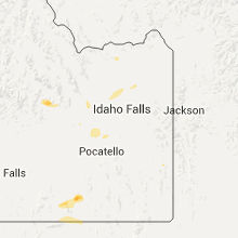
Hail Map for Wednesday, July 15, 2015

Number of Impacted Households on 7/15/2015
0
Impacted by 1" or Larger Hail
0
Impacted by 1.75" or Larger Hail
0
Impacted by 2.5" or Larger Hail
Square Miles of Populated Area Impacted on 7/15/2015
0
Impacted by 1" or Larger Hail
0
Impacted by 1.75" or Larger Hail
0
Impacted by 2.5" or Larger Hail


Cities Most Affected by Hail Storms of 7/15/2015
| Hail Size | Demographics of Zip Codes Affected | ||||||
|---|---|---|---|---|---|---|---|
| City | Count | Average | Largest | Pop Density | House Value | Income | Age |
| Cartwright, ND | 1 | 1.75 | 1.75 | 1 | $28k | $30.7k | 44.5 |
| Manhattan, KS | 1 | 1.75 | 1.75 | 192 | $89k | $27.9k | 24.4 |
| New Leipzig, ND | 1 | 1.75 | 1.75 | 1 | $20k | $29.6k | 55.5 |
Hail and Wind Damage Spotted on 7/15/2015
Filter by Report Type:Hail ReportsWind Reports
States Impacted
Kansas, New Jersey, Florida, Missouri, Arkansas, North Dakota, Minnesota, Alabama, Georgia, Wyoming, Colorado, Mississippi, Idaho, Nebraska, South DakotaKansas
| Local Time | Report Details |
|---|---|
| 7:49 AM CDT | Small tree limbs down. winds estimated between 50 and 60 mp in osage county KS, 58.4 miles WSW of Kansas City, MO |
| 9:08 AM CDT | Large tree down at 17th and claire in north olathe in johnson county KS, 19.1 miles SW of Kansas City, MO |
| 9:10 AM CDT | Multiple trees down within olathe in johnson county KS, 19.1 miles SW of Kansas City, MO |
| 9:13 AM CDT | 4 inch limb down 2 miles southwest of lenexa. estimated wind gusts 60-75 mp in johnson county KS, 15.3 miles SW of Kansas City, MO |
| 5:45 PM CDT | Quarter sized hail reported near Johnson, KS, 55.3 miles WSW of Garden City, KS |
| 5:45 PM CDT | Storm damage reported in stanton county KS, 55.3 miles WSW of Garden City, KS |
| 5:45 PM CDT | Power poles down. damage to houses from hail and street flooding was occurrin in stanton county KS, 55.3 miles WSW of Garden City, KS |
| 6:20 PM CDT | Golf Ball sized hail reported near Manhattan, KS, 10.4 miles ESE of Manhattan, KS |
| 6:33 PM CDT | Ping Pong Ball sized hail reported near Wamego, KS, 12.6 miles E of Manhattan, KS |
| 6:37 PM CDT | Storm damage reported in wabaunsee county KS, 15.7 miles ESE of Manhattan, KS |
| 6:50 PM CDT | Quarter sized hail reported near Manter, KS, 69.1 miles WSW of Garden City, KS |
| 6:58 PM CDT | Storm damage reported in russell county KS, 18.5 miles E of Hays, KS |
| 6:58 PM CDT | Quarter sized hail reported near Gorham, KS, 18.5 miles E of Hays, KS |
| 7:39 PM CDT | Quarter sized hail reported near Topeka, KS, 34.4 miles ESE of Manhattan, KS |
| 8:16 PM CDT | Pea size hail and heavy rain also reported in mitchell county KS, 77.6 miles ENE of Hays, KS |
| 8:16 PM CDT | Pea size hail and heavy rain also reported in mitchell county KS, 74.1 miles ENE of Hays, KS |
| 8:16 PM CDT | Pea size hail and heavy rainfall also reported in mitchell county KS, 73.5 miles ENE of Hays, KS |
| 8:22 PM CDT | Quarter sized hail reported near Beloit, KS, 73.5 miles ENE of Hays, KS |
| 8:27 PM CDT | Power lines/poles snapped and 8 inch diameter tree branches broke in mitchell county KS, 77.9 miles ENE of Hays, KS |
| 8:27 PM CDT | Storm damage reported in mitchell county KS, 76.7 miles ENE of Hays, KS |
| 8:27 PM CDT | Roof blown off auto parts store. tree snapped and fallen on two vehicle in mitchell county KS, 77.6 miles ENE of Hays, KS |
| 8:37 PM CDT | Estimated at 60 mp in haskell county KS, 23.5 miles SSE of Garden City, KS |
| 8:45 PM CDT | Storm damage reported in finney county KS, 19.3 miles SE of Garden City, KS |
| 8:53 PM CDT | Numerous trees down in jamestow in cloud county KS, 75.3 miles WNW of Manhattan, KS |
| 9:19 PM CDT | Storm damage reported in republic county KS, 71 miles NW of Manhattan, KS |
| 9:24 PM CDT | Storm damage reported in republic county KS, 72.2 miles NW of Manhattan, KS |
| 9:27 PM CDT | Pecan mobile mesonet in republic county KS, 64.4 miles NW of Manhattan, KS |
New Jersey
| Local Time | Report Details |
|---|---|
| 9:01 AM EDT | Storm damage reported in ocean county NJ, 80.8 miles S of Brooklyn, NY |
Florida
| Local Time | Report Details |
|---|---|
| 1:28 PM EDT | Storm damage reported in indian river county FL, 26.7 miles N of Port Saint Lucie, FL |
| 3:06 PM EDT | Palm beach county fire rescue reported powerlines down belvedere road and congress ave. this is very near the pbi airport which reported a 44 mph wind gus in palm beach county FL, 44.2 miles SSE of Port Saint Lucie, FL |
| 3:20 PM EDT | Tree down on top of a power line at river plantation road and coastal highway in wakulla county FL, 17.5 miles S of Tallahassee, FL |
| 8:10 PM EDT | Tree down at county rd 12 and meridian r in leon county FL, 15.9 miles N of Tallahassee, FL |
| 8:10 PM EDT | Tree down at county rd 12 and beadle r in leon county FL, 16 miles N of Tallahassee, FL |
| 8:11 PM EDT | Tree down at meridian rd and bannerman r in leon county FL, 10.3 miles N of Tallahassee, FL |
| 8:15 PM EDT | Tree down at shady grove way and applewood wa in leon county FL, 9.2 miles NNE of Tallahassee, FL |
Missouri
| Local Time | Report Details |
|---|---|
| 1:41 PM CDT | 6-8 inch diameter tree limb down in bolivar. picture passed on via faceboo in polk county MO, 28.4 miles NNW of Springfield, MO |
| 1:50 PM CDT | Quarter sized hail reported near Bolivar, MO, 24.4 miles N of Springfield, MO, quarter size hail reported by public |
| 2:20 PM CDT | Quarter sized hail reported near Pleasant Hope, MO, 17.4 miles N of Springfield, MO, report of quarter size hail near the city of pleasant hope. |
| 2:20 PM CDT | Report of winds up to 60 mph near the city of pleasant hop in polk county MO, 17.4 miles N of Springfield, MO |
| 2:40 PM CDT | Report of a tree that has fallen on a house in the city of fair grov in greene county MO, 14.1 miles NNE of Springfield, MO |
| 2:50 PM CDT | Report of a tree down approximately 10 inches in diameter near main and maple in the city of fair grov in greene county MO, 14.1 miles NNE of Springfield, MO |
| 9:17 PM CDT | Report of several trees down between pierce city and monet in barry county MO, 42.1 miles WSW of Springfield, MO |
Arkansas
| Local Time | Report Details |
|---|---|
| 2:50 PM CDT | Trees and power lines were blown down in beeb in white county AR, 31.1 miles NE of Little Rock, AR |
| 5:24 PM CDT | Trees down across hwy 5n between mountain home and midwa in baxter county AR, 76.6 miles SE of Springfield, MO |
| 5:26 PM CDT | Trees down on hwy 62e between mountain home and henderso in baxter county AR, 80.2 miles SE of Springfield, MO |
North Dakota
| Local Time | Report Details |
|---|---|
| 2:55 PM CDT | Report posted via social media. a few large 5 to 7 inch diameter tree branches were broken down. heavy rain and small hail accompanied the wind in cass county ND, 4.3 miles SSW of Fargo, ND |
| 5:25 PM CDT | Thunderstorm winds of 60 mph lasted about 5 minutes...to 530 p in morton county ND, 44.2 miles W of Bismarck, ND |
| 5:27 PM CDT | Quarter sized hail reported near Almont, ND, 37.3 miles W of Bismarck, ND, hail lasted around 3 minutes to 530 pm. |
| 6:05 PM CDT | Golf Ball sized hail reported near Cartwright, ND, 24.4 miles SW of Williston, ND, report from early wednesday evening in cartwright. report and photo forwarded to nws from broadcast media. |
| 5:10 PM MDT | Golf Ball sized hail reported near New Leipzig, ND, 66.2 miles WSW of Bismarck, ND, hail up to golfball size lasted until 628 pm |
| 5:30 PM MDT | Half Dollar sized hail reported near Hazen, ND, 55.9 miles NW of Bismarck, ND |
| 6:30 PM CDT | Quarter sized hail reported near Garrison, ND, 43.9 miles S of Minot, ND, pea to quarter sized hail observed from 630 pm cdt to 700 pm cdt |
| 6:30 PM CDT | Half Dollar sized hail reported near Alexander, ND, 21.2 miles S of Williston, ND, report received via social media. |
| 6:40 PM CDT | Quarter sized hail reported near Williston, ND, 14 miles SW of Williston, ND, very heavy rain accompanied the large hail. wind gusts were around 30 mph at time of report. |
| 5:40 PM MDT | Quarter sized hail reported near Hazen, ND, 55.9 miles NW of Bismarck, ND |
| 7:45 PM CDT | Ping Pong Ball sized hail reported near Cartwright, ND, 22.5 miles SSW of Williston, ND |
| 8:00 PM CDT | Quarter sized hail reported near Velva, ND, 25 miles SE of Minot, ND |
Minnesota
| Local Time | Report Details |
|---|---|
| 3:05 PM CDT | Quarter sized hail reported near Moorhead, MN, 5.4 miles SSE of Fargo, ND, pictures and report submitted via social media. dime to quarter sized hail...along with strong winds and very heavy rains. |
| 3:20 PM CDT | Report posted via social media. a few large 3 to 5 inch diameter tree branches were broken down. brief heavy rains and small hail accompanied the wind. time estimated b in clay county MN, 11 miles SE of Fargo, ND |
| 3:20 PM CDT | Quarter sized hail reported near Moorhead, MN, 5.4 miles ESE of Fargo, ND, pictures and report submitted via social media. dime to quarter sized hail...along with strong winds and very heavy rains. |
Alabama
| Local Time | Report Details |
|---|---|
| 3:10 PM CDT | New power outages reported in hueytown along with one tree down at dexter ct and holly st. winds est at 40mph from rada in jefferson county AL, 10.9 miles WSW of Birmingham, AL |
| 4:42 PM CDT | Trees down along highway 25 in bibb county AL, 34.2 miles SSW of Birmingham, AL |
| 5:08 PM CDT | Several trees reported down across western portions of chilton county in chilton county AL, 50.5 miles S of Birmingham, AL |
| 5:25 PM CDT | From ema and public reports-trees down south and east of billingsley... including along county rd 19... county rd 16 in autauga county AL, 57.1 miles NE of Camden, AL |
| 5:52 PM CDT | Multiple trees down in union springs in bullock county AL, 34.9 miles SSW of Auburn, AL |
| 6:30 PM CDT | Several trees down a couple miles south of the intersection of highway 69 and highway 25 in hale county AL, 50.3 miles NNW of Camden, AL |
| 6:34 PM CDT | A couple of trees down in aliceville one down on powerline in pickens county AL, 45.1 miles ESE of Starkville, MS |
| 8:05 PM CDT | Trees down in the city of demopolis along with power outage in marengo county AL, 48.5 miles NW of Camden, AL |
| 8:40 PM CDT | Tree down on county road 552 in coffee county AL, 68.5 miles NNE of Miramar Beach, FL |
| 8:55 PM CDT | Tree down on county road 655 in coffee county AL, 62.9 miles NNE of Miramar Beach, FL |
| 9:15 PM CDT | A tree was down on highway 85 near highway 27 intersectio in geneva county AL, 55.2 miles NNE of Miramar Beach, FL |
Georgia
| Local Time | Report Details |
|---|---|
| 4:30 PM EDT | Peak wind gust of 43 knot in chatham county GA, 11.7 miles ESE of Savannah, GA |
| 4:45 PM EDT | Tree down on lovers lane road in lee county GA, 77.6 miles WNW of Douglas, GA |
| 4:55 PM EDT | Tree down on trailer with people trapped inside. time estimated by rada in chatham county GA, 2.2 miles SW of Savannah, GA |
| 4:56 PM EDT | Tree down and powerlines down on solomon ave. time estimated based on rada in chatham county GA, 14.2 miles ESE of Savannah, GA |
| 4:56 PM EDT | Powerline down on a car. time estimated based on rada in chatham county GA, 12.5 miles ESE of Savannah, GA |
| 4:58 PM EDT | Tree down on jones ave. report relayed via twitte in chatham county GA, 15.2 miles ESE of Savannah, GA |
| 4:58 PM EDT | Tree down on 12th ave. report relayed via twitte in chatham county GA, 15.2 miles ESE of Savannah, GA |
| 5:00 PM EDT | Coffee county 911/dispatch reported a tree downed over a power line near the intersection of smith street and railroad street in broxton. time of damage based on radar in coffee county GA, 8.9 miles NNW of Douglas, GA |
| 5:09 PM EDT | Tree down on highway 18 in ben hill county GA, 26.2 miles NW of Douglas, GA |
| 5:13 PM EDT | Tree down on highway 90 salem church r in ben hill county GA, 37 miles NW of Douglas, GA |
| 5:13 PM EDT | Trees down at mud road and brooklet-denmark road. time estimated by rada in bulloch county GA, 39.3 miles WNW of Savannah, GA |
| 5:15 PM EDT | Tree down near the 3300 block of sylvester road in dougherty county GA, 71.5 miles W of Douglas, GA |
| 5:30 PM EDT | Report of either a tree or large branch down on a house in poulan in worth county GA, 55.5 miles W of Douglas, GA |
| 5:40 PM EDT | Trees were blown down in the eastern part of the county in irwin county GA, 18.9 miles WNW of Douglas, GA |
| 5:40 PM EDT | Power lines down on the south side of ocilla in irwin county GA, 24.5 miles WNW of Douglas, GA |
| 6:04 PM EDT | Tree down on john wells rd and hwy 196. time estimated by rada in long county GA, 41.6 miles WSW of Savannah, GA |
| 6:05 PM EDT | 911 call center received numerous reports of downed trees and power outages around downtown macon. some locations specifically experiencing the greatest wind damage inc in bibb county GA, 76.8 miles SE of Atlanta, GA |
| 6:05 PM EDT | Atkinson county 911/dispatch reports a tree downed over a road near the intersection of ice plant road and talmadge mckinnon road north of willacoochee. time of damage in atkinson county GA, 11.5 miles SW of Douglas, GA |
| 6:20 PM EDT | Tree on house on egret circle. time estimated by rada in bryan county GA, 17.5 miles SW of Savannah, GA |
| 6:38 PM EDT | Tree down on lake drive. time estimated by rada in liberty county GA, 23.8 miles SW of Savannah, GA |
| 6:38 PM EDT | Tree down on wye road. time estimated by rada in liberty county GA, 23.3 miles SW of Savannah, GA |
| 7:30 PM EDT | Several trees down in cair in grady county GA, 30.6 miles N of Tallahassee, FL |
| 7:30 PM EDT | Two trees down within the city of thomasville in thomas county GA, 32.9 miles NNE of Tallahassee, FL |
| 7:45 PM EDT | Tree down in grady count in grady county GA, 21.7 miles NNE of Tallahassee, FL |
| 7:45 PM EDT | Trees down in southern thomas county south of thomasville in thomas county GA, 24.9 miles NE of Tallahassee, FL |
| 9:10 PM EDT | Some trees down in miller county with power outages in miller county GA, 57.5 miles NNW of Tallahassee, FL |
Wyoming
| Local Time | Report Details |
|---|---|
| 2:32 PM MDT | Rock springs airport asos reported a 56 knot outflow wind gus in sweetwater county WY, 7.8 miles ESE of Rock Springs, WY |
| 4:43 PM MDT | Storm damage reported in carbon county WY, 87.1 miles SSW of Casper, WY |
| 5:35 PM MDT | Halleck ridge wydot site. sustained 51 mp in carbon county WY, 56.9 miles WNW of Laramie, WY |
| 6:32 PM MDT | Quarter sized hail reported near Newcastle, WY, 67.8 miles SW of Rapid City, SD, strong winds and heavy rain. wind speed unknown. |
| 6:53 PM MDT | Storm damage reported in converse county WY, 48.1 miles E of Casper, WY |
Colorado
| Local Time | Report Details |
|---|---|
| 3:08 PM MDT | Very strong winds. ripped screen door off of property. many branches up to 6 inch in diameter ripped from tree in baca county CO, 106.1 miles WSW of Garden City, KS |
| 3:30 PM MDT | Storm damage reported in baca county CO, 88.2 miles WSW of Garden City, KS |
| 3:30 PM MDT | Quarter sized hail reported near Two Buttes, CO, 88.2 miles WSW of Garden City, KS |
| 5:32 PM MDT | Storm damage reported in denver county CO, 19.3 miles ENE of Denver, CO |
| 5:33 PM MDT | Half Dollar sized hail reported near Walsh, CO, 80.9 miles WSW of Garden City, KS |
| 6:17 PM MDT | Wind gust at the rifle airport in garfield county CO, 56.1 miles NE of Grand Junction, CO |
Mississippi
| Local Time | Report Details |
|---|---|
| 5:15 PM CDT | Trees down on numerous roads including highway 8...girlscout road...hugh white state park road and marina road. one tree fell on a house and a power line is also dow in grenada county MS, 57.7 miles WNW of Starkville, MS |
| 6:28 PM CDT | A few trees down on highway 35 around holcomb in grenada county MS, 70.3 miles WNW of Starkville, MS |
| 7:25 PM CDT | A few trees were dow in carroll county MS, 63.4 miles W of Starkville, MS |
Idaho
| Local Time | Report Details |
|---|---|
| 4:50 PM MDT | Quarter sized hail reported near Saint Anthony, ID, 37.6 miles NNE of Idaho Falls, ID, channel 8 viewer submitted video via social media of hail between 0.25 and 0.50 inches. time estimated. |
| 5:30 PM MDT | Quarter sized hail reported near Blackfoot, ID, 26 miles SW of Idaho Falls, ID, channel 8 viewer submitted a photo of 1 inch hail in blackfoot. time estimated. |
Nebraska
| Local Time | Report Details |
|---|---|
| 7:58 PM CDT | Ping Pong Ball sized hail reported near Red Cloud, NE, 58.4 miles S of Grand Island, NE |
| 9:39 PM CDT | 67 mph wind gust reported by pecan mobile mesone in thayer county NE, 75.3 miles SSE of Grand Island, NE |
| 10:12 PM CDT | Storm damage reported in jefferson county NE, 73.1 miles NNW of Manhattan, KS |
| 2:50 AM CDT | Trees down at highway 75 and platteview road. relayed by local medi in sarpy county NE, 11.1 miles S of Omaha, NE |
South Dakota
| Local Time | Report Details |
|---|---|
| 7:00 PM MDT | Storm damage reported in custer county SD, 40.9 miles SW of Rapid City, SD |
| 7:47 PM MDT | Storm damage reported in fall river county SD, 43.1 miles S of Rapid City, SD |
Connect with Interactive Hail Maps