

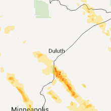
Hail Map for Tuesday, July 19, 2011

Number of Impacted Households on 7/19/2011
0
Impacted by 1" or Larger Hail
0
Impacted by 1.75" or Larger Hail
0
Impacted by 2.5" or Larger Hail
Square Miles of Populated Area Impacted on 7/19/2011
0
Impacted by 1" or Larger Hail
0
Impacted by 1.75" or Larger Hail
0
Impacted by 2.5" or Larger Hail


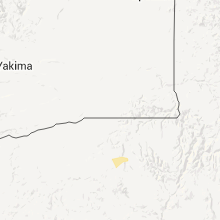


Cities Most Affected by Hail Storms of 7/19/2011
| Hail Size | Demographics of Zip Codes Affected | ||||||
|---|---|---|---|---|---|---|---|
| City | Count | Average | Largest | Pop Density | House Value | Income | Age |
| Birchwood, WI | 3 | 2.25 | 2.50 | 16 | $105k | $35.6k | 52.3 |
| Hughesville, PA | 2 | 1.75 | 1.75 | 89 | $88k | $34.4k | 43.3 |
| Springbrook, WI | 1 | 2.00 | 2.00 | 10 | $75k | $33.2k | 49.1 |
| Saint Thomas, ND | 1 | 1.75 | 1.75 | 2 | $48k | $36.0k | 46.5 |
| Radisson, WI | 1 | 1.75 | 1.75 | 9 | $48k | $25.8k | 46.2 |
| Newark, MD | 1 | 1.75 | 1.75 | 26 | $94k | $39.9k | 43.6 |
Hail and Wind Damage Spotted on 7/19/2011
Filter by Report Type:Hail ReportsWind Reports
States Impacted
Minnesota, Kentucky, Pennsylvania, Delaware, North Carolina, Maryland, Oregon, Virginia, Montana, Ohio, Wisconsin, New Jersey, Texas, West Virginia, Colorado, Wyoming, Utah, Nebraska, Indiana, South Dakota, North Dakota, MichiganMinnesota
| Local Time | Report Details |
|---|---|
| 7:00 AM CDT | Building under construction at fairgrounds demolishe in wadena county MN, 72.3 miles S of Bemidji, MN |
| 9:30 AM CDT | Branches and limbs up to 10 inches in diameter downed in oak par in benton county MN, 57.3 miles NNW of Minneapolis, MN |
| 9:41 AM CDT | A few large trees felle in mille lacs county MN, 56.6 miles NNW of Minneapolis, MN |
| 2:45 PM UTC | Several two foot diameter trees either uprooted or split in two.a few screen doors ripped off house in mille lacs county MN, 56.2 miles NNW of Minneapolis, MN |
| 10:05 AM CDT | Several trees down...power ou in mille lacs county MN, 57.1 miles NNW of Minneapolis, MN |
| 10:17 AM CDT | Several trees and powerlines dow in mille lacs county MN, 43.8 miles NNW of Minneapolis, MN |
| 10:18 AM CDT | Several large trees in mille lacs county MN, 43.8 miles NNW of Minneapolis, MN |
| 10:19 AM CDT | Measured at airport in mille lacs county MN, 43.8 miles NNW of Minneapolis, MN |
| 3:20 PM UTC | Three inch diameter branches severed. occurred near 19 jarvis st. time estimate in sherburne county MN, 35.6 miles NNW of Minneapolis, MN |
| 3:20 PM UTC | Twenty four inch diameter trees toppled. some snapped in tw in sherburne county MN, 35.6 miles NNW of Minneapolis, MN |
| 3:20 PM UTC | Twenty four inch diameter trees toppled. some snapped in two. occurred near 25019 jarvis st. in zimmerma in sherburne county MN, 35.6 miles NNW of Minneapolis, MN |
| 3:20 PM UTC | Twenty four inch diameter trees uprooted. occurred near 19 jarvis st. time estimated in sherburne county MN, 35.6 miles NNW of Minneapolis, MN |
| 3:20 PM UTC | Twenty four inch diameter trees uprooted. occurred near 205th st. and county road 1 in sherburne county MN, 35.6 miles NNW of Minneapolis, MN |
| 4:03 PM UTC | Measured at aprsnet sit in anoka county MN, 18.9 miles NNW of Minneapolis, MN |
| 4:05 PM UTC | Trees 12 to 18 inches in diameter toppled. damage occurred on west side of cit in anoka county MN, 17.1 miles NNW of Minneapolis, MN |
| 4:13 PM UTC | Twenty four inch diameter trees toppled. some snapped in two. occurred near hunter lak in sherburne county MN, 35.6 miles NNW of Minneapolis, MN |
| 4:33 PM UTC | Quarter sized hail reported near Roseville, MN, 5.1 miles NE of Minneapolis, MN |
| 11:34 AM CDT | Quarter sized hail reported near New Brighton, MN, 7 miles NNE of Minneapolis, MN |
| 11:35 AM CDT | Quarter sized hail reported near New Brighton, MN, 7 miles NNE of Minneapolis, MN, occurred near county road e2 and 35w. |
| 4:47 PM UTC | Quarter sized hail reported near Roseville, MN, 6.3 miles ENE of Minneapolis, MN, occurred near snelling and highway 46 at the rosedale mall. |
| 4:55 PM UTC | Half Dollar sized hail reported near Roseville, MN, 6.3 miles ENE of Minneapolis, MN |
| 5:06 PM UTC | Half Dollar sized hail reported near St Paul, MN, 8.3 miles ESE of Minneapolis, MN |
| 5:07 PM UTC | Quarter sized hail reported near St Paul, MN, 8.3 miles ESE of Minneapolis, MN |
| 5:20 PM UTC | Quarter sized hail reported near Mendota Heights, MN, 9.2 miles SE of Minneapolis, MN |
| 5:27 PM UTC | Quarter sized hail reported near Mendota Heights, MN, 9.2 miles SE of Minneapolis, MN |
| 7:10 PM UTC | Several trees snapped off over hightway 73 in carlton county MN, 38.4 miles WSW of Duluth, MN |
| 7:10 PM UTC | 9 inch trees snapped. large oak tree down on powerlin in carlton county MN, 32.7 miles WSW of Duluth, MN |
| 7:28 PM UTC | Numberous maple trees down in carlton county MN, 29.4 miles WSW of Duluth, MN |
| 7:28 PM UTC | Numberous maple trees down. top third of 8 inch pine snapped of in carlton county MN, 29.4 miles WSW of Duluth, MN |
| 8:00 PM UTC | Several 9 inch diameter trees dow in carlton county MN, 35.5 miles WSW of Duluth, MN |
| 8:27 PM UTC | 6 to 8 diameter tree limbs were blown dow in itasca county MN, 52 miles SSW of International Falls, MN |
Kentucky
| Local Time | Report Details |
|---|---|
| 3:18 PM UTC | Tree down on a hous in bourbon county KY, 38.5 miles NNW of Irvine, KY |
| 9:00 PM UTC | Quarter sized hail reported near Frankfort, KY, 50.9 miles ENE of Louisville, KY |
| 9:04 PM UTC | Storm damage reported in franklin county KY, 48.2 miles ENE of Louisville, KY |
| 9:25 PM UTC | Quarter sized hail reported near Frankfort, KY, 47.7 miles ENE of Louisville, KY |
| 9:30 PM UTC | Quarter sized hail reported near Frankfort, KY, 45.9 miles E of Louisville, KY, report of greater than 1 inch hail mixed with pea to three-quarter inch size hail... also estimates greater than 65 mph winds occurred shortly after the hail observatio |
| 9:31 PM UTC | Trees and powerlines down in franklin county KY, 47.7 miles ENE of Louisville, KY |
| 9:31 PM UTC | Trees and powerlines down in franklin county KY, 46.1 miles ENE of Louisville, KY |
| 10:01 PM UTC | Trees down on alton station and wildcat roads in anderson county KY, 45.2 miles E of Louisville, KY |
| 10:15 PM UTC | Minor roof damage and tree limbs down 2.5 miles southeast of high grov in nelson county KY, 14.8 miles ESE of Louisville, KY |
| 11:30 PM UTC | Tree down on courts hill rd. another tree down on ky-1159. time estimated from rada in bracken county KY, 32.5 miles SE of Cincinnati, OH |
| 12:40 AM UTC | Numerous trees down across northern half of county in bourbon county KY, 41 miles NNW of Irvine, KY |
| 3:45 AM UTC | Numerous trees and power lines down across western portions of downtown louisville...north of the shively area. one tree fell on a car and two trees fell on houses. a f in jefferson county KY, 16.1 miles N of Louisville, KY |
Pennsylvania
| Local Time | Report Details |
|---|---|
| 7:20 PM UTC | Several trees down in montour twp. report relayed via montour twp fire chei in columbia county PA, 52.9 miles WSW of Scranton, PA |
| 9:55 PM UTC | Golf Ball sized hail reported near Penn, PA, 53.5 miles W of Scranton, PA, quarter to golf ball sized hail on route 220 |
| 10:08 PM UTC | Golf Ball sized hail reported near Penn, PA, 53.5 miles W of Scranton, PA, quarter to golf ball sized hail on route 220 |
Delaware
| Local Time | Report Details |
|---|---|
| 7:25 PM UTC | Tree down near lewes in sussex county DE, 30.9 miles N of Ocean City, MD |
| 7:30 PM UTC | Tree down at intersection of canterberry rd and andrews lake rd in kent county DE, 55.3 miles NNW of Ocean City, MD |
| 7:45 PM UTC | Tree down in harrington in kent county DE, 48.2 miles NNW of Ocean City, MD |
| 8:00 PM UTC | Tree down near fenwick island in sussex county DE, 8.8 miles NNE of Ocean City, MD |
North Carolina
| Local Time | Report Details |
|---|---|
| 7:34 PM UTC | Tree down in stokes county NC, 60.9 miles SSW of Roanoke, VA |
| 7:40 PM UTC | Tree down in stokes county NC, 60.7 miles SSW of Roanoke, VA |
| 9:07 PM UTC | One tree was reported down on a power line along ellisboro road near the guilford rockingham county lin in guilford county NC, 69.8 miles S of Roanoke, VA |
| 9:19 PM UTC | One tree down near the intersection of old highway 29 and holland road in shelto in caswell county NC, 57 miles SSE of Roanoke, VA |
Maryland
| Local Time | Report Details |
|---|---|
| 8:33 PM UTC | Large branch across driveway in severna park area in anne arundel county MD, 15.8 miles SSE of Baltimore, MD |
| 8:43 PM UTC | Quarter sized hail reported near Berlin, MD, 7.4 miles W of Ocean City, MD |
| 8:48 PM UTC | Tree downed onto a residence in worcester county MD, 7.4 miles W of Ocean City, MD |
| 8:55 PM UTC | Golf Ball sized hail reported near Newark, MD, 12.6 miles WSW of Ocean City, MD |
| 10:02 PM UTC | Big tree snapped off 20 feet above ground. 30 to 40 trees uprooted. hay wagon blown over. large tree onto neighbors garag in washington county MD, 62.7 miles WNW of Baltimore, MD |
| 10:05 PM UTC | Multiple reports of trees down between state hwy 65 and rt 40...wnw of boonsbor in washington county MD, 60.3 miles WNW of Baltimore, MD |
| 10:10 PM UTC | Multiple reports of trees down between state hwy 65 and rt 40...wnw of boonsbor in washington county MD, 60.3 miles WNW of Baltimore, MD |
| 12:06 AM UTC | Tops of pine trees sheared off 10-15 feet above ground. diameter approx 10 inches. another tree 20 inches in diameter twisted. powerlines down around trees and residenc in st. marys county MD, 65.1 miles S of Baltimore, MD |
| 12:06 AM UTC | Numerous tree branches down. diameter of branches 2 inches and large in st. marys county MD, 65.1 miles S of Baltimore, MD |
| 12:10 AM UTC | Multiple large trees down in yard and neighbors yard. diameter 6 to 8 inches. top of one tree was snapped off 20 feet above groun in st. marys county MD, 63.6 miles S of Baltimore, MD |
| 12:10 AM UTC | Several trees down near intersection of clarkes landing road and md rt 23 in st. marys county MD, 67 miles S of Baltimore, MD |
| 12:10 AM UTC | Approx. 20-30 trees down around hollywood md area. several trees down on clarkes landing r in st. marys county MD, 66.4 miles S of Baltimore, MD |
| 12:35 AM UTC | Tree down across doctor jack road in cecil county MD, 36 miles NE of Baltimore, MD |
Oregon
| Local Time | Report Details |
|---|---|
| 9:00 PM UTC | Quarter sized hail reported near La Grande, OR, 54.6 miles SSE of Walla Walla, WA, campers at morgan lake reported quarter size hail that destroyed tents and then afterwards winds gusting to 70 mph blew them over. the hail completely covered the groun |
Virginia
| Local Time | Report Details |
|---|---|
| 9:23 PM UTC | Power and cable lines down on holland road just north of the nc borde in city of danville county VA, 57 miles SSE of Roanoke, VA |
| 1:40 AM UTC | Multiple trees reported down along newland road in newlan in richmond county VA, 57 miles NE of Richmond, VA |
| 2:05 AM UTC | Trees down on highway 17 bypass...just north of tappahannock in essex county VA, 51.8 miles NE of Richmond, VA |
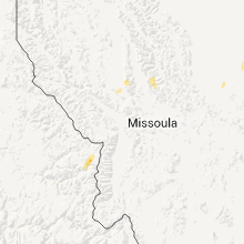
Montana
| Local Time | Report Details |
|---|---|
| 9:30 PM UTC | Quarter sized hail reported near Whitefish, MT, 0.3 miles E of Whitefish, MT |
| 9:35 PM UTC | Half Dollar sized hail reported near Carter, MT, 32.9 miles NNE of Great Falls, MT |
| 10:20 PM UTC | Public estimates wind gust of 65 mph or greate in chouteau county MT, 44.9 miles WSW of Havre, MT |
| 10:20 PM UTC | Quarter sized hail reported near Lolo, MT, 9.8 miles SW of Missoula, MT |
| 11:30 PM UTC | Quarter sized hail reported near Lolo, MT, 9.8 miles SW of Missoula, MT |
| 11:36 PM UTC | Quarter sized hail reported near St Ignatius, MT, 31.2 miles N of Missoula, MT |
Ohio
| Local Time | Report Details |
|---|---|
| 9:49 PM UTC | Tree down in 6000 block of green ridge rd. time estimated from rada in pike county OH, 60.2 miles S of Columbus, OH |
| 10:50 PM UTC | 5 trees blown down...another healthy tree broken off and thrown 15 feet into car and pole barn...which were both damage in clermont county OH, 27.3 miles ESE of Cincinnati, OH |
| 11:05 PM UTC | A couple of trees down and numerous power outages across far southern clermont count in clermont county OH, 29.4 miles SE of Cincinnati, OH |
Wisconsin
| Local Time | Report Details |
|---|---|
| 9:52 PM UTC | Small tree branches blowing across highway 35. dime size hai in douglas county WI, 28.3 miles S of Duluth, MN |
| 9:55 PM UTC | Tree uprooted at wayside res in douglas county WI, 28.3 miles S of Duluth, MN |
| 10:10 PM UTC | Measured wind speed 59 mph. torential rainfall obscuring visibility. trees down along highway 5 in washburn county WI, 54 miles SSE of Duluth, MN |
| 10:10 PM UTC | Six 12 inch diameter trees down blocking highway 3 in douglas county WI, 39.8 miles SSE of Duluth, MN |
| 10:15 PM UTC | Large tree down on smith bridge roa in douglas county WI, 42.5 miles SSE of Duluth, MN |
| 10:40 PM UTC | Power out in the town of haywar in sawyer county WI, 61.4 miles SSE of Duluth, MN |
| 10:40 PM UTC | Quarter sized hail reported near Stone Lake, WI, 68.7 miles SSE of Duluth, MN, estimated wind speed of 50 to 60 mph. |
| 10:40 PM UTC | Tennis Ball sized hail reported near Birchwood, WI, 78.2 miles SSE of Duluth, MN |
| 10:50 PM UTC | Golf Ball sized hail reported near Radisson, WI, 78.2 miles SSE of Duluth, MN |
| 10:57 PM UTC | Half Dollar sized hail reported near Stone Lake, WI, 73.3 miles SSE of Duluth, MN |
| 11:00 PM UTC | Hen Egg sized hail reported near Springbrook, WI, 65.7 miles SSE of Duluth, MN |
| 11:00 PM UTC | Many 16 inch diameter maples snapped off. large oak topped and large oak uproote in washburn county WI, 65.7 miles SSE of Duluth, MN |
| 11:10 PM UTC | Several brances down. 8 inch poplar branch snapped. at 800 pm...power was still out in winte in sawyer county WI, 78.3 miles W of Rhinelander, WI |
| 11:10 PM UTC | Golf Ball sized hail reported near Birchwood, WI, 82.2 miles SSE of Duluth, MN |
| 6:10 PM CDT | Tennis Ball sized hail reported near Birchwood, WI, 84.3 miles SSE of Duluth, MN |
| 11:15 PM UTC | A few trees and powerlines down along 600 block of peterso in rusk county WI, 82.9 miles W of Rhinelander, WI |
| 11:18 PM UTC | Trees and branches were blown in washburn county WI, 49.4 miles SSE of Duluth, MN |
| 11:28 PM UTC | A few power lines and trees down along highway 8 in tow in rusk county WI, 77.8 miles W of Rhinelander, WI |
| 12:22 AM UTC | 40 foot tree down. power lost across tow in polk county WI, 61.2 miles NE of Minneapolis, MN |
| 12:22 AM UTC | Power lost across tow in polk county WI, 61.2 miles NE of Minneapolis, MN |
| 12:25 AM UTC | Storm damage reported in taylor county WI, 77.1 miles WSW of Rhinelander, WI |
| 12:30 AM UTC | Tree down along polley road west of hwy 7 in taylor county WI, 76 miles WSW of Rhinelander, WI |
| 12:40 AM UTC | Trees down. boats lifted. docks destroyed. numerous buildings damaged near pipe lake. damage also reported around johnstown township. time estimated based on radar. dam in polk county WI, 63.6 miles NE of Minneapolis, MN |
| 12:45 AM UTC | Tree down over roa in polk county WI, 60 miles NE of Minneapolis, MN |
| 12:52 AM UTC | Tree damage in barron county WI, 61.8 miles ENE of Minneapolis, MN |
| 12:56 AM UTC | Large branches down. strong wind lasted for 10-15 minute in barron county WI, 59.4 miles ENE of Minneapolis, MN |
| 1:14 AM UTC | Storm damage reported in taylor county WI, 71.7 miles WSW of Rhinelander, WI |
| 1:15 AM UTC | 18 inch diameter tree snapped. delayed report...time estimate in marathon county WI, 74 miles SW of Rhinelander, WI |
| 1:15 AM UTC | Quarter sized hail reported near Comstock, WI, 67.8 miles ENE of Minneapolis, MN |
| 1:25 AM UTC | Few trees down across road in barron county WI, 75 miles ENE of Minneapolis, MN |
| 1:30 AM UTC | Tree down across roa in barron county WI, 82.3 miles ENE of Minneapolis, MN |
| 1:30 AM UTC | Tree down across roa in barron county WI, 73.7 miles ENE of Minneapolis, MN |
| 1:33 AM UTC | Storm damage reported in clark county WI, 75.9 miles NE of La Crosse, WI |
| 1:40 AM UTC | Tree down across roa in barron county WI, 82.3 miles ENE of Minneapolis, MN |
| 1:40 AM UTC | Tree down across roa in barron county WI, 73.7 miles ENE of Minneapolis, MN |
| 1:40 AM UTC | Tree down across roa in dunn county WI, 76.6 miles E of Minneapolis, MN |
| 1:55 AM UTC | Storm damage reported in clark county WI, 82.3 miles SW of Rhinelander, WI |
| 1:55 AM UTC | Trees down across roa in chippewa county WI, 88.6 miles E of Minneapolis, MN |
| 2:05 AM UTC | Trees down across highway 17 in chippewa county WI, 85.5 miles N of La Crosse, WI |
| 2:12 AM UTC | Tree down at intersection of hwy 73 and hickor in taylor county WI, 79.6 miles WSW of Rhinelander, WI |
| 2:30 AM UTC | Trees down on power lin in eau claire county WI, 70.6 miles N of La Crosse, WI |
| 2:38 AM UTC | Storm damage reported in clark county WI, 75.3 miles NE of La Crosse, WI |
| 2:40 AM UTC | Storm damage reported in clark county WI, 66.3 miles NNE of La Crosse, WI |
| 2:50 AM UTC | Tree dow in portage county WI, 74.9 miles SSW of Rhinelander, WI |
| 2:52 AM UTC | Trees dow in portage county WI, 74.9 miles SSW of Rhinelander, WI |
| 2:56 AM UTC | Storm damage reported in clark county WI, 75.1 miles NNE of La Crosse, WI |
| 3:10 AM UTC | A number of trees knocked down near northfield. one was north of hwy 121 along county road g. another along degroot rd east of northfield off of hwy 12 in jackson county WI, 46 miles N of La Crosse, WI |
| 3:15 AM UTC | Estimated between 60 and 70 mph. 12 inch diameter branch dow in portage county WI, 76.6 miles W of Green Bay, WI |
| 3:15 AM UTC | 8 inch tree down. time estimated. 1.22 inches of rain fell in 20 minutes as wel in portage county WI, 75.3 miles W of Green Bay, WI |
| 3:15 AM UTC | Light pole down at intersection of hover st and county highway b. delayed report...time estimate in portage county WI, 75.3 miles W of Green Bay, WI |
| 3:20 AM UTC | A couple trees knocked down across the road just south of merrillan near garage r in jackson county WI, 46.7 miles NNE of La Crosse, WI |
| 3:30 AM UTC | Penny size hail also reporte in wood county WI, 80.9 miles SSW of Rhinelander, WI |
| 4:25 AM UTC | Large branches fell and tents were damaged to approx 250 scouts at camp freeland leslie on the adams and marquette county line in central wisconsi in adams county WI, 51.4 miles NNW of Madison, WI |
| 4:44 AM UTC | Tree damage with estimated wind gusts to around 60 mp in green lake county WI, 55.2 miles NNE of Madison, WI |
| 5:00 AM UTC | Scattered power outages across green lake county due to winds breaking tree branches which then impacted power lines. city of berlin is without power. other locations w in green lake county WI, 57.1 miles NNE of Madison, WI |
| 5:18 AM UTC | Large tree branch down on road near cty rd yy and hwy 49 intersection in dodge county WI, 56.6 miles NE of Madison, WI |
| 5:22 AM UTC | Large tree branch blown down...blocking several lanes of traffi in dodge county WI, 38.4 miles NE of Madison, WI |
| 5:45 AM UTC | 2 inch branches down in washington county WI, 52.9 miles ENE of Madison, WI |
New Jersey
| Local Time | Report Details |
|---|---|
| 10:00 PM UTC | Trees dow in gloucester county NJ, 84.8 miles SW of Brooklyn, NY |
| 10:00 PM UTC | Trees down in salem county NJ, 80.6 miles ENE of Baltimore, MD |
| 10:21 PM UTC | Numerous trees were knocked down throughout gloucester count in gloucester county NJ, 84.7 miles ENE of Baltimore, MD |
| 10:22 PM UTC | A few trees knocke dow in camden county NJ, 83.1 miles SW of Brooklyn, NY |
| 11:13 PM UTC | Trees dow in cumberland county NJ, 76.1 miles E of Baltimore, MD |
| 11:15 PM UTC | Trees down in salem county NJ, 68.3 miles ENE of Baltimore, MD |
| 11:30 PM UTC | Trees down in salem county NJ, 66.6 miles ENE of Baltimore, MD |
| 11:45 PM UTC | Tree down on house in lawrence twp in cumberland county NJ, 68.9 miles N of Ocean City, MD |
| 11:52 PM UTC | Numerous trees down and road flooding in cumberland county NJ, 66.8 miles N of Ocean City, MD |
| 11:55 PM UTC | Trees and wires down in downe twp in cumberland county NJ, 63.9 miles N of Ocean City, MD |
Texas
| Local Time | Report Details |
|---|---|
| 10:00 PM UTC | Numerous large trees uprooted and large tree branches down. straightline microburst winds. nws damage survey in comal county TX, 31.3 miles NE of San Antonio, TX |
| 10:10 PM UTC | Minor mobile home and tree damage on the east side of la pryo in zavala county TX, 70.6 miles ESE of Del Rio, TX |
West Virginia
| Local Time | Report Details |
|---|---|
| 10:35 PM UTC | Tree down in meadow brook subdivision in jefferson county WV, 63.3 miles W of Baltimore, MD |
| 10:45 PM UTC | Large branches blown down on several pear trees. shingles also removed from the roof of one hom in jefferson county WV, 64.4 miles W of Baltimore, MD |
Colorado
| Local Time | Report Details |
|---|---|
| 5:21 PM MDT | Quarter sized hail reported near Brighton, CO, 20.3 miles NNE of Denver, CO, heavy rain. estimated 40 to 50 mph wind. |
| 11:56 PM UTC | Wind measured with davis wind equipment. also heavy rai in adams county CO, 10.5 miles N of Denver, CO |
Wyoming
| Local Time | Report Details |
|---|---|
| 11:30 PM UTC | A building under construction was knocked down by strong wind in lincoln county WY, 69.9 miles WNW of Rock Springs, WY |
| 1:35 AM UTC | Storm damage reported in sublette county WY, 75.8 miles W of Riverton, WY |
| 1:40 AM UTC | Numerous tree branches down. some minor damage caused from downed large tree branche in park county WY, 91.2 miles SSW of Billings, MT |
| 2:15 AM UTC | Storm damage reported in crook county WY, 54.4 miles NE of Gillette, WY |
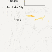
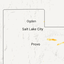
Utah
| Local Time | Report Details |
|---|---|
| 1:45 AM UTC | Quarter sized hail reported near Tabiona, UT, 52 miles N of Price, UT |
Nebraska
| Local Time | Report Details |
|---|---|
| 3:03 AM UTC | Storm damage reported in cheyenne county NE, 62 miles SE of Scottsbluff, NE |
| 3:03 AM UTC | Storm damage reported in banner county NE, 25.7 miles S of Scottsbluff, NE |
| 3:13 AM UTC | Storm damage reported in cheyenne county NE, 62 miles SE of Scottsbluff, NE |
| 3:22 AM UTC | Storm damage reported in cheyenne county NE, 48 miles SE of Scottsbluff, NE |
| 3:37 AM UTC | Metal shed was blown off foundation. 10 inch diameter tree branch went through the roof of a house. lots of branches down throughout tow in morrill county NE, 32 miles ESE of Scottsbluff, NE |
| 3:38 AM UTC | Storm damage reported in morrill county NE, 32 miles ESE of Scottsbluff, NE |
| 3:40 AM UTC | Winds started about 5 min ago at est 50 mph and have increased. some reports of branches down on hwy 38 in morrill county NE, 32 miles ESE of Scottsbluff, NE |
| 3:52 AM UTC | Storm damage reported in cheyenne county NE, 48.5 miles SE of Scottsbluff, NE |
| 4:10 AM UTC | Storm damage reported in box butte county NE, 44 miles ENE of Scottsbluff, NE |
| 4:13 AM UTC | Storm damage reported in box butte county NE, 44 miles ENE of Scottsbluff, NE |
| 4:13 AM UTC | Storm damage reported in box butte county NE, 44 miles ENE of Scottsbluff, NE |
| 4:45 AM UTC | A 36 inch diameter branch was torn from a large tre in sheridan county NE, 53.4 miles ENE of Scottsbluff, NE |
Indiana
| Local Time | Report Details |
|---|---|
| 3:53 AM UTC | Power line dow in harrison county IN, 16.9 miles NW of Louisville, KY |
| 3:58 AM UTC | Trees and limbs reported down...particularly in and near lanesville including high ridge lane... st. johns church rd.... and downtown in harrison county IN, 22.5 miles NW of Louisville, KY |
South Dakota
| Local Time | Report Details |
|---|---|
| 4:00 AM UTC | 5 trees snapped off. one about 1.5 ft diameter. strong roaring noise. 15 minutes of very heavy rai in harding county SD, 92.8 miles NNW of Rapid City, SD |
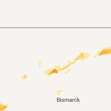
North Dakota
| Local Time | Report Details |
|---|---|
| 9:15 AM UTC | Quarter sized hail reported near Lankin, ND, 45.9 miles ENE of Devils Lake, ND, hail in various sizes from one quarter to one inch in diameter. |
| 9:50 AM UTC | Large tree hit house in towner county ND, 30.5 miles NNW of Devils Lake, ND |
| 10:00 AM UTC | Quarter sized hail reported near Starkweather, ND, 20.6 miles N of Devils Lake, ND, 1.51 inches of rain |
| 10:05 AM UTC | Storm damage reported in mclean county ND, 35 miles SSW of Minot, ND |
| 10:17 AM UTC | Also reported quarter size hail. report relay via broadcast medi in mclean county ND, 28.7 miles S of Minot, ND |
| 10:20 AM UTC | Trees downed and uprooted in ma in mclean county ND, 28.7 miles S of Minot, ND |
| 10:55 AM UTC | Golf Ball sized hail reported near St Thomas, ND, 69.3 miles ENE of Devils Lake, ND, hail in various sizes from dimes to golf balls. |
| 11:20 AM UTC | Large trees down in fordville. approximate time linked to rada in walsh county ND, 49.9 miles E of Devils Lake, ND |
| 11:20 AM UTC | Tree fell on pickup truck with no reported injuries. time estimated using radar imager in grand forks county ND, 49.6 miles E of Devils Lake, ND |
| 11:35 AM UTC | Large trees down in city of forest river. time linked to radar image in walsh county ND, 64.6 miles E of Devils Lake, ND |
| 11:40 AM UTC | Power poles down at intersection of nd 18 and walsh 15. time approximated using radar imager in walsh county ND, 58.7 miles ENE of Devils Lake, ND |
| 11:45 AM UTC | Group of power poles down. time approximated using radar imager in walsh county ND, 69 miles ENE of Devils Lake, ND |
| 11:45 AM UTC | Box elder trees toppled. bent flagpole in pierce county ND, 54.8 miles E of Minot, ND |
| 11:50 AM UTC | Steel pole barn destroyed in benson county ND, 46.8 miles WNW of Devils Lake, ND |
| 11:52 AM UTC | Storm damage reported in pierce county ND, 3071 miles ENE of Caribou, ME |
| 11:55 AM UTC | 5-10 inch diamter branches dow in benson county ND, 41.5 miles WNW of Devils Lake, ND |
| 11:55 AM UTC | 40-50 foot tall trees dow in benson county ND, 41.5 miles WNW of Devils Lake, ND |
| 11:55 AM UTC | 4-6 inch diamater branches down. grain elevator doors blown of in benson county ND, 41.5 miles WNW of Devils Lake, ND |
| 11:55 AM UTC | 5-10 inch diamter branches dow in benson county ND, 42.2 miles WNW of Devils Lake, ND |
| 11:55 AM UTC | 40-50 foot tall trees dow in benson county ND, 40.4 miles WNW of Devils Lake, ND |
| 11:55 AM UTC | 4-6 inch diamater branches down. grain elevator doors blown of in benson county ND, 42.4 miles WNW of Devils Lake, ND |
| 11:55 AM UTC | Straight line winds estimated to 75 mph. 60 foot spruce trees down. heavy rain 0.80 inche in pierce county ND, 50.9 miles WNW of Devils Lake, ND |
| 11:56 AM UTC | Measured wind gust at rugby awo in pierce county ND, 3071 miles ENE of Caribou, ME |
| 11:58 AM UTC | Measured wind gust at the grafton ndaw in walsh county ND, 71.7 miles WSW of Roseau, MN |
| 11:58 AM UTC | 4 inch diameter tree branch down in walsh county ND, 74.2 miles WSW of Roseau, MN |
Michigan
| Local Time | Report Details |
|---|---|
| 10:49 AM UTC | Golf Ball sized hail reported near , , 57.9 miles WNW of Marquette, MI, most of the hail was between dime and quarter sized...but there were a few golf ball sized hail stones. in addition...wind gusts were estimated at around 40 mph. |
Connect with Interactive Hail Maps