

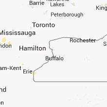
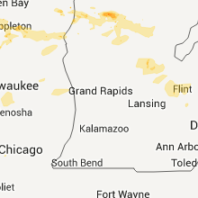
Hail Map for Wednesday, July 25, 2012

Number of Impacted Households on 7/25/2012
0
Impacted by 1" or Larger Hail
0
Impacted by 1.75" or Larger Hail
0
Impacted by 2.5" or Larger Hail
Square Miles of Populated Area Impacted on 7/25/2012
0
Impacted by 1" or Larger Hail
0
Impacted by 1.75" or Larger Hail
0
Impacted by 2.5" or Larger Hail


Cities Most Affected by Hail Storms of 7/25/2012
| Hail Size | Demographics of Zip Codes Affected | ||||||
|---|---|---|---|---|---|---|---|
| City | Count | Average | Largest | Pop Density | House Value | Income | Age |
| Granville, IA | 3 | 1.92 | 2.00 | 7 | $49k | $41.0k | 39.4 |
| Two Rivers, WI | 1 | 1.75 | 1.75 | 230 | $81k | $42.2k | 44.4 |
| Moville, IA | 1 | 1.75 | 1.75 | 18 | $91k | $43.8k | 39.4 |
| Saint Libory, NE | 1 | 1.75 | 1.75 | 13 | $80k | $36.4k | 40.8 |
| Ruthven, IA | 1 | 1.75 | 1.75 | 12 | $55k | $32.0k | 46.3 |
| Paullina, IA | 1 | 1.75 | 1.75 | 7 | $53k | $34.5k | 47.9 |
| Statesville, NC | 1 | 1.75 | 1.75 | 193 | $103k | $42.5k | 40.1 |
| Jewell, KS | 1 | 1.75 | 1.75 | 3 | $23k | $32.0k | 48.3 |
| Wakeeney, KS | 1 | 1.75 | 1.75 | 7 | $49k | $30.4k | 49.0 |
Hail and Wind Damage Spotted on 7/25/2012
Filter by Report Type:Hail ReportsWind Reports
States Impacted
Michigan, Florida, South Dakota, Georgia, North Carolina, Nebraska, Kansas, Texas, Iowa, Oklahoma, Ohio, Wisconsin, Missouri, Illinois, New YorkMichigan
| Local Time | Report Details |
|---|---|
| 11:30 AM EDT | Tree down on hous in clare county MI, 74.4 miles NE of Grand Rapids, MI |
| 8:50 PM EDT | Trees and branches dow in wexford county MI, 23.7 miles SSE of Traverse City, MI |
| 8:54 PM EDT | Quarter sized hail reported near Manton, MI, 22.7 miles SSE of Traverse City, MI |
| 9:01 PM EDT | Quarter sized hail reported near Manton, MI, 26.4 miles SSE of Traverse City, MI |
| 9:03 PM EDT | Half Dollar sized hail reported near Manton, MI, 29 miles SSE of Traverse City, MI |
| 9:03 PM EDT | Half Dollar sized hail reported near Manton, MI, 26.4 miles SSE of Traverse City, MI |
| 9:14 PM EDT | Trees down in selma townshi in wexford county MI, 33.2 miles SSE of Traverse City, MI |
| 9:14 PM EDT | Trees down in cherry grove townshi in wexford county MI, 38.7 miles S of Traverse City, MI |
| 9:50 PM EDT | About 100 trees down at old 27 and the clare roscommon county border in roscommon county MI, 58.3 miles SE of Traverse City, MI |
| 10:00 PM EDT | Dozens of trees down in are in clare county MI, 59 miles SE of Traverse City, MI |
| 10:00 PM EDT | Trees down in are in clare county MI, 60.4 miles SE of Traverse City, MI |
| 10:00 PM EDT | Trees down in are in clare county MI, 70.9 miles SE of Traverse City, MI |
| 10:05 PM EDT | Reports of large tree limbs down and power outages county wid in gladwin county MI, 77.5 miles SE of Traverse City, MI |
| 10:10 PM EDT | Measured by viewer. many trees down and wire in mason county MI, 69 miles SW of Traverse City, MI |
| 10:15 PM EDT | Numerous trees abd wires dow in osceola county MI, 51.3 miles SSE of Traverse City, MI |
| 10:15 PM EDT | Numerous trees and wires dow in osceola county MI, 51.3 miles SSE of Traverse City, MI |
| 10:16 PM EDT | Trees down. time estimated by rada in gladwin county MI, 75.2 miles NNW of Flint, MI |
| 10:19 PM EDT | Six inch branches down. time estimated by rada in gladwin county MI, 68.2 miles NNW of Flint, MI |
| 10:40 PM EDT | Wires dow in oceana county MI, 56.4 miles NW of Grand Rapids, MI |
| 10:58 PM EDT | Reports of large tree limbs down and power outages county wid in gladwin county MI, 77.5 miles SE of Traverse City, MI |
| 11:20 PM EDT | Tree on wire.wire on fir in clare county MI, 72.5 miles NNE of Grand Rapids, MI |
| 11:20 PM EDT | Tree on wire. wire on fir in clare county MI, 72.5 miles NNE of Grand Rapids, MI |
| 11:23 PM EDT | Tree down on hous in clare county MI, 64.6 miles SSE of Traverse City, MI |
| 11:23 PM EDT | Trees down in yard in isabella county MI, 50.4 miles NE of Grand Rapids, MI |
| 11:30 PM EDT | Tree down on hous in clare county MI, 74.4 miles NE of Grand Rapids, MI |
| 11:35 PM EDT | A large tree and several wires were blown dow in tuscola county MI, 46 miles NNE of Flint, MI |
| 11:49 PM EDT | A large tree was blown down near purdy and mac donald r in huron county MI, 67 miles NE of Flint, MI |
| 11:55 PM EDT | Isabella county central dispatch reported a few trees and wires down in mt pleasant and shepherd. time estimate in isabella county MI, 63.1 miles NE of Grand Rapids, MI |
| 12:00 AM EDT | Multiple trees and powerlines down across the northern part of bay county in bay county MI, 62.2 miles NNW of Flint, MI |
| 12:18 AM EDT | A large tree was blown down in tow in sanilac county MI, 51.6 miles ENE of Flint, MI |
| 12:25 AM EDT | A power pole was blown dow in sanilac county MI, 43.8 miles ENE of Flint, MI |
| 12:30 AM EDT | At luther rd and bay rd in saginaw county MI, 33.8 miles NNW of Flint, MI |
| 12:30 AM EDT | Gratiot county central dispatch had a couple reports of power lines down and trees down in the northeast part of the county. time estimate in gratiot county MI, 48.6 miles NW of Flint, MI |
| 12:42 AM EDT | Numerous tree branches down across the city. largest size seen was 4 inches in diamete in saginaw county MI, 31.2 miles NNW of Flint, MI |
| 1:00 AM EDT | A large tree was blown down onto m 1 in tuscola county MI, 20.2 miles NNE of Flint, MI |
| 1:05 AM EDT | Trees were reported down in and around lexingto in sanilac county MI, 61.1 miles ENE of Flint, MI |
| 1:05 AM EDT | Large willow reported down across coldwater road near north elms road in genesee county MI, 8.3 miles NW of Flint, MI |
Florida
| Local Time | Report Details |
|---|---|
| 1:55 PM CDT | Forty to fifty foot tree down near waffle house in mariann in jackson county FL, 62.3 miles WNW of Tallahassee, FL |
| 1:55 PM CDT | Roof and awning damage to two businesses at highway 90 and hall stree in jackson county FL, 62.9 miles WNW of Tallahassee, FL |
| 4:15 PM EDT | Tree down near intersection of north meridian road and fairbanks ferry roa in leon county FL, 15.9 miles N of Tallahassee, FL |
| 4:30 PM EDT | Tree and power line down in quinc in gadsden county FL, 20.3 miles WNW of Tallahassee, FL |
| 4:55 PM EDT | Power line down near intersection of weems road and acadian blv in leon county FL, 3.9 miles ENE of Tallahassee, FL |
| 5:00 PM EDT | Tree down near intersection of old st augustine road and verdura roa in leon county FL, 6.9 miles ESE of Tallahassee, FL |
South Dakota
| Local Time | Report Details |
|---|---|
| 1:15 PM MDT | Quarter sized hail reported near Rapid City, SD, 4.6 miles SW of Rapid City, SD |
| 1:15 PM MDT | Half Dollar sized hail reported near Rapid City, SD, 6.8 miles SW of Rapid City, SD, hail lasted 5 minutes. most of it was from half inch to three quarter inch in diameter. |
| 5:35 PM CDT | Quarter sized hail reported near Bristol, SD, 37.6 miles ESE of Aberdeen, SD |
Georgia
| Local Time | Report Details |
|---|---|
| 3:25 PM EDT | Several trees down around whigam. reported on facebook and relayed by wct in grady county GA, 30.4 miles N of Tallahassee, FL |
| 3:25 PM EDT | Several trees down around whigham. reported on facebook and relayed by wct in grady county GA, 30.4 miles N of Tallahassee, FL |
| 3:55 PM EDT | Several trees dow in decatur county GA, 35.9 miles NNW of Tallahassee, FL |
| 4:00 PM EDT | Several trees down in grady county in grady county GA, 19.7 miles NNW of Tallahassee, FL |
| 4:57 PM EDT | Fort stewart asos reported east wind of 24 gusting to 53 kt in liberty county GA, 31.4 miles WSW of Savannah, GA |
| 5:49 PM EDT | Tree down on a powerline along inner perimeter r in lowndes county GA, 50.4 miles SSW of Douglas, GA |
| 5:59 PM EDT | Several trees down on hwy 377 in lee county GA, 80.2 miles WNW of Douglas, GA |
| 6:00 PM EDT | 5 trees down near smith street and james road just west of i-7 in lowndes county GA, 55.2 miles SSW of Douglas, GA |
| 6:59 PM EDT | 2 trees down on hwy 41 in randolph county GA, 77 miles SE of Auburn, AL |
| 7:08 PM EDT | Tree down on lower shellman rd in randolph county GA, 75 miles SE of Auburn, AL |
| 7:45 PM EDT | Numerous trees down countywide in randolph county GA, 64.1 miles SSE of Auburn, AL |
| 7:48 PM EDT | Quarter sized hail reported near Cordele, GA, 57.2 miles WNW of Douglas, GA, crisp county 911 relayed a report from a deputy in east crisp of hail from slightly larger than pennys to quarters. time estimated from radar. |
North Carolina
| Local Time | Report Details |
|---|---|
| 3:55 PM EDT | Quarter sized hail reported near Morganton, NC, 58.5 miles NW of Charlotte, NC |
| 4:08 PM EDT | Quarter sized hail reported near Maiden, NC, 30.3 miles NW of Charlotte, NC, hail observed on buffalo shoals road and water plant road. time determined from radar data. |
| 4:24 PM EDT | Trees down in wilkes county NC, 64.1 miles N of Charlotte, NC |
| 4:37 PM EDT | Several trees down on hazelton loop. time determined from radar dat in iredell county NC, 24.1 miles N of Charlotte, NC |
| 5:05 PM EDT | Golf Ball sized hail reported near Statesville, NC, 55.3 miles N of Charlotte, NC, hail observed on linneys mill road. |
| 5:06 PM EDT | Tree down blocking jennings road near rocky cree in iredell county NC, 55 miles N of Charlotte, NC |
| 5:08 PM EDT | Half Dollar sized hail reported near Statesville, NC, 54.3 miles N of Charlotte, NC |
| 5:46 PM EDT | Quarter sized hail reported near Statesville, NC, 39.2 miles N of Charlotte, NC |
Nebraska
| Local Time | Report Details |
|---|---|
| 4:07 PM CDT | Quarter sized hail reported near St Libory, NE, 10.7 miles N of Grand Island, NE, quarter size hail and 40 mph winds in st. libory reported by trained spotter. |
| 4:15 PM CDT | Golf Ball sized hail reported near St Libory, NE, 9.4 miles N of Grand Island, NE, delayed report of golf ball size hail courtesy of nssl shave. |
| 4:30 PM CDT | Ping Pong Ball sized hail reported near Grand Island, NE, 8.8 miles N of Grand Island, NE, delayed report of ping pong size hail courtesy of nssl shave. |
| 4:53 PM CDT | Half Dollar sized hail reported near Chapman, NE, 9.1 miles NE of Grand Island, NE, trained spotter reports 1.25 inch hail. |
| 5:48 PM CDT | Storm damage reported in thurston county NE, 62.5 miles NNW of Omaha, NE |
| 6:00 PM CDT | Tree branches down. some crops flattened. estimated near 60 mp in dodge county NE, 56 miles WNW of Omaha, NE |
| 6:00 PM CDT | Quarter sized hail reported near Dodge, NE, 56 miles WNW of Omaha, NE |
Kansas
| Local Time | Report Details |
|---|---|
| 4:20 PM CDT | 1 1/2 inch diameter branch estimated 10 foot long blown down in butler county KS, 36.8 miles NE of Wichita, KS |
| 4:23 PM CDT | Part of roof damaged and power lines down at 83rd and nw topeka blvd...likely due to microburst in shawnee county KS, 48.4 miles E of Manhattan, KS |
| 4:23 PM CDT | Part of roof damaged and power lines down at 83rd and nw topeka blvd...likely due to microburst. updated report of 5 homes with roof damage and 1 home with an enclosed in shawnee county KS, 48.4 miles E of Manhattan, KS |
| 4:34 PM CDT | Storm damage reported in rush county KS, 25.2 miles SSE of Hays, KS |
| 4:40 PM CDT | Storm damage reported in rush county KS, 22 miles SSE of Hays, KS |
| 4:42 PM CDT | 2-3 inch diamter tree limbs blown down in sedgwick county KS, 12.2 miles SSE of Wichita, KS |
| 5:24 PM CDT | 59 mph gust reported at the russell aso in russell county KS, 26 miles E of Hays, KS |
| 5:30 PM CDT | Delayed report...time estimated...em reports power lines down and large tree across road near the intersection of kent and cedarwood roads in douglas county KS, 38.1 miles WSW of Kansas City, MO |
| 5:34 PM CDT | Storm damage reported in russell county KS, 27.2 miles ENE of Hays, KS |
| 5:42 PM CDT | Power poll snapped 2 miles north of atlant in cowley county KS, 34.5 miles ESE of Wichita, KS |
| 5:45 PM CDT | Quarter sized hail reported near Atlanta, KS, 34.5 miles ESE of Wichita, KS |
| 6:01 PM CDT | Trained spotter reported pea size hail and 60 mph wind gust in mitchell county KS, 76.3 miles NE of Hays, KS |
| 6:20 PM CDT | Law enforcement reports irrigation pivot flipped over by thunderstorm wind gusts in graham county KS, 42.3 miles NW of Hays, KS |
| 6:20 PM CDT | Quarter sized hail reported near Bogue, KS, 38.8 miles NNW of Hays, KS |
| 6:40 PM CDT | Blew a trash dumpster 40 f in nemaha county KS, 52.3 miles NNE of Manhattan, KS |
| 6:42 PM CDT | Delayed report. time estimated from rada in nemaha county KS, 48.7 miles NNE of Manhattan, KS |
| 6:43 PM CDT | Two large trees blown down 3 miles west of barnar in lincoln county KS, 69.9 miles ENE of Hays, KS |
| 7:05 PM CDT | Golf Ball sized hail reported near Wakeeney, KS, 38.6 miles WNW of Hays, KS, hail size varried from quarter to golfball size. |
| 7:28 PM CDT | Estimated 60 mph wind gusts. round hay bale rolled across road near greenwood cemetar in mitchell county KS, 76 miles WNW of Manhattan, KS |
| 7:29 PM CDT | 8 inch tree limbs downe in washington county KS, 44.1 miles NNW of Manhattan, KS |
| 7:30 PM CDT | Two farm buildings damaged...wind estimated at 65 to 70 mph in washington county KS, 42.9 miles NNW of Manhattan, KS |
| 7:40 PM CDT | Tree down near highway 81 and gold road. relayed by wfo ict in cloud county KS, 60.5 miles WNW of Manhattan, KS |
| 7:43 PM CDT | Storm damage reported in washington county KS, 41.2 miles NNW of Manhattan, KS |
| 7:45 PM CDT | At a residence at 30th road and highway 15 in northern clay county an 8 inch tree limb was snapped. a metal shed 10 feet by 14 feet was tossed nearly 300 yards across t in clay county KS, 39.8 miles NW of Manhattan, KS |
| 7:54 PM CDT | 2 foot diameter base of locust tree snapped half way on the base. 1 foot tree limbs broken off maple tree in washington county KS, 34.6 miles NW of Manhattan, KS |
| 9:01 PM CDT | Storm damage reported in finney county KS, 8.4 miles E of Garden City, KS |
| 9:01 PM CDT | Speci kgck 260201z auto 02043g52kt 1sm tsra sq...pk wnd 02052/0201. in finney county KS, 8.4 miles E of Garden City, KS |
| 9:15 PM CDT | Winds estimate 55-60 mph in finney county KS, 9.7 miles ESE of Garden City, KS |
| 9:26 PM CDT | Golf Ball sized hail reported near Garden City, KS, 4.8 miles SE of Garden City, KS |
| 11:33 PM CDT | Golf Ball sized hail reported near Jewell, KS, 84 miles NE of Hays, KS, golf ball size hail fell for approximately one minute and was accompanied by estimated 60 mph winds. |
| 12:15 AM CDT | Awos located at the stockton airport measured a gust of 69 mph. wind damage was reported approximately 14 miles west-southwest of stockton. 4 power poles were damaged in rooks county KS, 35.3 miles N of Hays, KS |
Texas
| Local Time | Report Details |
|---|---|
| 4:27 PM CDT | Storm damage reported in oldham county TX, 32.4 miles NW of Amarillo, TX |
| 7:15 PM CDT | Strong winds associated with a microburst resulted in wind damage at ducote airpark. several hangar doors were blown of in tom green county TX, 90.8 miles SW of Abilene, TX |
| 10:00 PM CDT | West texas mesonet report in terry county TX, 38.8 miles SW of Lubbock, TX |
| 12:00 AM CDT | Storm damage reported in crosby county TX, 39.7 miles E of Lubbock, TX |
Iowa
| Local Time | Report Details |
|---|---|
| 5:15 PM CDT | Quarter sized hail reported near Alton, IA, 48.8 miles WNW of Storm Lake, IA |
| 5:15 PM CDT | Half Dollar sized hail reported near Alton, IA, 46.8 miles WNW of Storm Lake, IA |
| 5:25 PM CDT | Quarter sized hail reported near Spirit Lake, IA, 57 miles N of Storm Lake, IA |
| 5:25 PM CDT | Hen Egg sized hail reported near Granville, IA, 41.8 miles WNW of Storm Lake, IA |
| 5:30 PM CDT | Half Dollar sized hail reported near Moville, IA, 44.8 miles W of Storm Lake, IA |
| 5:30 PM CDT | Half Dollar sized hail reported near Moville, IA, 46.8 miles WSW of Storm Lake, IA |
| 5:31 PM CDT | Quarter sized hail reported near Spirit Lake, IA, 55.5 miles N of Storm Lake, IA |
| 5:34 PM CDT | Golf Ball sized hail reported near Granville, IA, 43 miles NW of Storm Lake, IA |
| 5:35 PM CDT | Winds estimated around 60 mph with lots of corn blown down. also pea size hai in woodbury county IA, 61.4 miles WSW of Storm Lake, IA |
| 5:35 PM CDT | Hen Egg sized hail reported near Granville, IA, 41.8 miles NW of Storm Lake, IA |
| 5:38 PM CDT | Golf Ball sized hail reported near Paullina, IA, 36.9 miles NW of Storm Lake, IA |
| 5:47 PM CDT | Golf Ball sized hail reported near Moville, IA, 45.6 miles WSW of Storm Lake, IA |
| 6:07 PM CDT | Half Dollar sized hail reported near Terril, IA, 47.8 miles NNE of Storm Lake, IA |
| 6:23 PM CDT | Golf Ball sized hail reported near Ruthven, IA, 42.4 miles NNE of Storm Lake, IA, hail as large as golfballs. |
| 7:05 PM CDT | Measured wind gust at algona idot rwis sit in kossuth county IA, 52.3 miles W of Mason City, IA |
| 7:10 PM CDT | Storm damage reported in kossuth county IA, 54.3 miles W of Mason City, IA |
| 7:20 PM CDT | Time estimated. also branches dow in kossuth county IA, 52.9 miles W of Mason City, IA |
| 7:20 PM CDT | Quarter sized hail reported near Algona, IA, 53.3 miles W of Mason City, IA |
| 7:35 PM CDT | Large 6 to 8 inch diameter tree branch down along with dime size hail. time estimated by rada in humboldt county IA, 48.9 miles WSW of Mason City, IA |
| 7:35 PM CDT | From idot awos sit in carroll county IA, 46.3 miles SSE of Storm Lake, IA |
| 7:37 PM CDT | Widespread damage throughout the town of carroll. numerous branches...power lines...and streets signs down. from weather-eye-radio. time estimated by rada in carroll county IA, 43.5 miles SSE of Storm Lake, IA |
| 7:37 PM CDT | Small limbs breaking. estimated 50 mph wind in carroll county IA, 47.2 miles SSE of Storm Lake, IA |
| 7:40 PM CDT | Multiple tree branches down throughout the town of breda...generally 1 inch in diamete in carroll county IA, 34.2 miles SSE of Storm Lake, IA |
| 7:45 PM CDT | Tree branches of 6 to 8 inch diameter down. branches down in town as wel in webster county IA, 51.3 miles E of Storm Lake, IA |
| 7:46 PM CDT | Big limbs down everywhere. caseys diesel pump blown over and laying on its side. tree laying on top of car. crop damage. time estimated. from kcha radi in calhoun county IA, 42.3 miles SE of Storm Lake, IA |
| 7:48 PM CDT | From kcci tv schoolnet site in carroll county IA, 42.7 miles SSE of Storm Lake, IA |
| 7:50 PM CDT | Branches and power lines dow in calhoun county IA, 33.8 miles ESE of Storm Lake, IA |
| 7:55 PM CDT | Quarter sized hail reported near Britt, IA, 30.5 miles W of Mason City, IA, crop damage in britt. street signs also down in town. |
| 7:55 PM CDT | Powerlines down in carroll. large branches caused damaged to a house and porch in carrol in carroll county IA, 43.5 miles SSE of Storm Lake, IA |
| 7:55 PM CDT | Powerlines dow in carroll county IA, 41.5 miles SE of Storm Lake, IA |
| 7:55 PM CDT | 8 inch and 6 inch limb down in yar in wright county IA, 49.6 miles SW of Mason City, IA |
| 8:00 PM CDT | A few 3 foot diameter trees down. a 30 foot long camper attached to a truck blown over. several crops damaged. time estimated by rada in carroll county IA, 36.7 miles SSE of Storm Lake, IA |
| 8:03 PM CDT | Quarter sized hail reported near Belmond, IA, 29.1 miles SW of Mason City, IA, nickel to quarter size hail reported. wind gusts estimated at 50 mph. |
| 8:08 PM CDT | Quarter sized hail reported near Belmond, IA, 29.1 miles SW of Mason City, IA, multiple reports of dime to quarter sized hail in town. |
| 8:10 PM CDT | Storm damage reported in webster county IA, 49.4 miles ESE of Storm Lake, IA |
| 8:10 PM CDT | Many tree branches down in town. some blocking streets. armstar sign just hanging to its base. estimated winds 70 mph. time estimated by rada in webster county IA, 53 miles ESE of Storm Lake, IA |
| 8:10 PM CDT | Multiple 4 to 6 inch diameter branches down. no structural damag in carroll county IA, 42.3 miles SSE of Storm Lake, IA |
| 8:12 PM CDT | Branches down from trees in the city par in webster county IA, 53 miles ESE of Storm Lake, IA |
| 8:15 PM CDT | 60 to 65 mph wind gusts estimated in boxholm. multiple 3 to 4 inch diameter tree limbs down along with several transformers blown down. time estimated by rada in boone county IA, 47.5 miles NNW of Des Moines, IA |
| 8:15 PM CDT | Quarter sized hail reported near Belmond, IA, 29.6 miles SW of Mason City, IA |
| 8:27 PM CDT | Reported by earlham police departmen in madison county IA, 27 miles WSW of Des Moines, IA |
| 8:30 PM CDT | Lots of trees down including one possibly on fire. some broken windows too. from kimt tv viewer. time estimate in cerro gordo county IA, 17.2 miles SW of Mason City, IA |
| 8:31 PM CDT | Storm damage reported in boone county IA, 37.7 miles NW of Des Moines, IA |
| 8:31 PM CDT | Tree limbs of 3 to 4 inches in diameter dow in boone county IA, 47.5 miles NNW of Des Moines, IA |
| 8:31 PM CDT | Two to three inch diameter trees down in story county IA, 41.4 miles N of Des Moines, IA |
| 8:37 PM CDT | Sustained winds of 65 mph measured with anemometer. also penny sized hai in marshall county IA, 45.7 miles NE of Des Moines, IA |
| 8:40 PM CDT | A plane was flipped at the ames airport in story county IA, 27.6 miles N of Des Moines, IA |
| 8:40 PM CDT | Several 5 inch diameter tree limbs down throughout the town of callenda in webster county IA, 50.1 miles ESE of Storm Lake, IA |
| 8:40 PM CDT | Power out in maxwell in story county IA, 23.5 miles NNE of Des Moines, IA |
| 8:40 PM CDT | Corn bins blown onto the roa in franklin county IA, 20.7 miles SW of Mason City, IA |
| 8:40 PM CDT | Tree damage...tree on power line with power out. delayed report and time estimate in boone county IA, 32.5 miles NNW of Des Moines, IA |
| 8:43 PM CDT | Idot rwis site along highway 30 near marshalltown in marshall county IA, 47.9 miles NE of Des Moines, IA |
| 8:43 PM CDT | Reported by iowa dot rwis along us 3 in marshall county IA, 47.9 miles NE of Des Moines, IA |
| 8:46 PM CDT | Estimated wind gusts of 50 to 60 mph in boone county IA, 38.7 miles NNW of Des Moines, IA |
| 8:50 PM CDT | Also penny sized hail in clayton county IA, 63.4 miles NNE of Cedar Rapids, IA |
| 8:50 PM CDT | Storm damage reported in story county IA, 27.6 miles N of Des Moines, IA |
| 8:50 PM CDT | Large tree limb...about 1 foot in diameter...down on isu campus along with several brances 3 to 4 inches in diameter. time estimated from rada in story county IA, 29.7 miles N of Des Moines, IA |
| 8:50 PM CDT | Near blanchard roof of a horse barn taken off by thunderstorm wind gusts in page county IA, 58.1 miles SE of Omaha, NE |
| 8:53 PM CDT | 3-4 inch diameter tree down at 8th and h. crews working on it. other small branches down. trash can lid blown off concrete bin. 5-6 inch tree also snapped at the east p in story county IA, 30.9 miles NNE of Des Moines, IA |
| 8:54 PM CDT | Six inch tree granch down in rolland with several other branches 3 to 6 inches in diameter down in story county IA, 40.5 miles N of Des Moines, IA |
| 8:57 PM CDT | Storm damage reported in story county IA, 41.4 miles N of Des Moines, IA |
| 9:00 PM CDT | Quarter sized hail reported near Garnavillo, IA, 66.9 miles S of La Crosse, WI |
| 9:03 PM CDT | Kcci tv schoolnet site in story county IA, 32.8 miles NNE of Des Moines, IA |
| 9:04 PM CDT | 60 mph plus wind gusts with pea sized hail. also secondary report of wind damage west of gilbert. from story county em in story county IA, 40.5 miles N of Des Moines, IA |
| 9:05 PM CDT | Power lines dow in story county IA, 21.4 miles N of Des Moines, IA |
| 9:07 PM CDT | Quarter sized hail reported near Story City, IA, 38 miles N of Des Moines, IA |
| 9:09 PM CDT | Power line down in colfax in jasper county IA, 20.4 miles ENE of Des Moines, IA |
| 9:12 PM CDT | Reported by kcci-tv schoolne in hamilton county IA, 49.7 miles N of Des Moines, IA |
| 9:24 PM CDT | Report of large tree branches down and power lines in the cit in buchanan county IA, 35.8 miles NNW of Cedar Rapids, IA |
| 9:24 PM CDT | Report of 3 inch diameter tree limb dow in buchanan county IA, 35.6 miles NNW of Cedar Rapids, IA |
| 9:30 PM CDT | Idot wind sensor along bridge. possibly higher than adjacent reports due to less friction along water and sensor elevation. on outflow ahead of storm passag in marion county IA, 31.9 miles ESE of Des Moines, IA |
| 9:30 PM CDT | Multiple reports of tree limbs and trees down in quesq in buchanan county IA, 35.8 miles NNW of Cedar Rapids, IA |
| 9:30 PM CDT | Delayed report. time estimated. six to seven 40 to 70 foot tall trees down in town. one fell onto a house. about 20 limbs 30 to 40 feet long down. numerous branches 10 in buchanan county IA, 35.8 miles NNW of Cedar Rapids, IA |
| 9:38 PM CDT | Large tree snapped in half. delayed report. time estimated by rada in grundy county IA, 58.1 miles NE of Des Moines, IA |
| 9:38 PM CDT | Large tree and limbs down in chickasaw county IA, 36.1 miles ESE of Mason City, IA |
| 9:45 PM CDT | Power outages in town. tree branches down. wind busted out window of hom in chickasaw county IA, 36.1 miles ESE of Mason City, IA |
| 9:50 PM CDT | Tree limbs up to 5 inches in diameter are dow in buchanan county IA, 34.2 miles N of Cedar Rapids, IA |
| 9:52 PM CDT | Report relayed by the emergency manager in delaware county IA, 27.3 miles NNE of Cedar Rapids, IA |
| 10:02 PM CDT | Corrected...wind gust of 57 kts measure in poweshiek county IA, 43 miles WSW of Cedar Rapids, IA |
| 10:07 PM CDT | Delayed report of trees and tree limbs down as well as power lines. wind speed estimated at 70 mph. report relayed by the emergency manager. time was estimate in delaware county IA, 35.9 miles NNE of Cedar Rapids, IA |
| 10:13 PM CDT | Numerous reports of trees and power lines down across town in fayette county IA, 64.9 miles ESE of Mason City, IA |
| 10:23 PM CDT | Numerous reports of trees and power lines down across town in fayette county IA, 65.2 miles SSW of La Crosse, WI |
| 10:25 PM CDT | Summary from clayton county law enforcement. 17 reports of power lines down across county. at least 30 reports of trees down. 1 one inch hail report in guttenberg in clayton county IA, 62.6 miles NNE of Cedar Rapids, IA |
| 10:25 PM CDT | Quarter sized hail reported near Fayette, IA, 62.7 miles N of Cedar Rapids, IA |
| 10:30 PM CDT | Tree limbs down. relayed by spotter de23. time estimate in dubuque county IA, 47.9 miles NE of Cedar Rapids, IA |
| 10:30 PM CDT | Barn roof blown off. relayed by spotter de23. time estimate in delaware county IA, 42.1 miles NE of Cedar Rapids, IA |
| 10:40 PM CDT | Estimated wind spee in johnson county IA, 9.5 miles S of Cedar Rapids, IA |
| 10:44 PM CDT | Spotter estimated wind gus in linn county IA, 1.9 miles SSE of Cedar Rapids, IA |
| 10:45 PM CDT | Storm damage reported in linn county IA, 7.1 miles SSW of Cedar Rapids, IA |
| 10:48 PM CDT | 18 inch diameter tree down in clayton county IA, 48.6 miles NNE of Cedar Rapids, IA |
| 10:48 PM CDT | Power out across town. a few tree branches down in clayton county IA, 48.6 miles NNE of Cedar Rapids, IA |
| 10:50 PM CDT | Report of power lines down on the northwest side of cedar rapids. a report of a traffic light down at nw ellis and nw edgewoo in linn county IA, 0.5 miles SSE of Cedar Rapids, IA |
| 11:08 PM CDT | A 6 inch tree tree was pushed over by thunderstorm winds. mostly small branches down elsewhere. heavy rain is fallin in johnson county IA, 20.1 miles S of Cedar Rapids, IA |
| 11:16 PM CDT | Report of trees blocking the road in mount vernon as well as a tree on a hous in linn county IA, 13.6 miles ESE of Cedar Rapids, IA |
| 11:53 PM CDT | Power line down in clinto in clinton county IA, 75 miles E of Cedar Rapids, IA |
| 12:20 AM CDT | Numerous trees and branches down. delayed report. time estimate in lee county IA, 23.8 miles NE of Kahoka, MO |
| 12:35 AM CDT | Greatly delayed report. time is estimated based on radar. spotter reported extremely heavy winds with numerous tree limbs and trees down. some were rotten but others we in lee county IA, 25.1 miles NE of Kahoka, MO |
Oklahoma
| Local Time | Report Details |
|---|---|
| 5:40 PM CDT | Storm damage reported in woods county OK, 43.7 miles NNE of Woodward, OK |
| 5:45 PM CDT | Storm damage reported in woods county OK, 43.7 miles NNE of Woodward, OK |
| 6:05 PM CDT | Storm damage reported in woods county OK, 43.7 miles NNE of Woodward, OK |
| 7:00 PM CDT | 68 mph gust at the hugo mesonet statio in choctaw county OK, 42.1 miles SE of Atoka, OK |
Ohio
| Local Time | Report Details |
|---|---|
| 7:51 PM EDT | Trees and large limbs downed. time estimated from rada in miami county OH, 70.7 miles N of Cincinnati, OH |
| 3:25 AM EDT | A few trees reported down by media in town of costonia... ohio. this is acorrestion of a previous repor in jefferson county OH, 32.8 miles W of Pittsburgh, PA |
| 3:45 AM EDT | Two large trees uprooted in costonia from thunderstorm wind in jefferson county OH, 32.8 miles W of Pittsburgh, PA |
Wisconsin
| Local Time | Report Details |
|---|---|
| 7:40 PM CDT | One tree and powerlines down. time estimated by rada in outagamie county WI, 22.1 miles WSW of Green Bay, WI |
| 7:44 PM CDT | Power lines down at monroe st and willow st. time estimated by rada in outagamie county WI, 20.3 miles SW of Green Bay, WI |
| 8:07 PM CDT | Gusty winds and half inch hail reporte in manitowoc county WI, 31.9 miles SSE of Green Bay, WI |
| 8:10 PM CDT | 10 trees down in tow in manitowoc county WI, 34.6 miles SSE of Green Bay, WI |
| 8:10 PM CDT | Storm damage reported in manitowoc county WI, 34.6 miles SSE of Green Bay, WI |
| 8:13 PM CDT | Quarter sized hail reported near Two Rivers, WI, 33.5 miles SE of Green Bay, WI |
| 8:15 PM CDT | Golf Ball sized hail reported near Two Rivers, WI, 33.5 miles SE of Green Bay, WI, golf ball size hail as well as a downed flag pole and chairs thrown across yard due to strong winds. report via wluk news. time estimated by radar. |
| 9:44 PM CDT | A few trees and power lines down in grant county WI, 62.1 miles NE of Cedar Rapids, IA |
| 9:48 PM CDT | A barn down along with numerous trees in grant county WI, 65.7 miles WSW of Madison, WI |
| 9:54 PM CDT | Tree branches down. also 1/2 inch hail observed in grant county WI, 59 miles WSW of Madison, WI |
| 11:12 PM CDT | Several reports of trees down across town in grant county WI, 68.8 miles WSW of Madison, WI |
| 11:22 PM CDT | Several power lines down across town in grant county WI, 64.3 miles W of Madison, WI |
| 11:41 PM CDT | Large swath of tree damage about 100 yards wide. located near county road p and nankee road. time estimate in iowa county WI, 52 miles W of Madison, WI |
| 11:44 PM CDT | Trees and power lines down around avoca. time estimate in iowa county WI, 48.4 miles W of Madison, WI |
| 11:51 PM CDT | Trees and power lines down. power outages also reported. time estimate in lafayette county WI, 55.1 miles SW of Madison, WI |
| 11:52 PM CDT | 6 inch diameter tree and several branches down along riverview ridge driv in richland county WI, 50 miles WNW of Madison, WI |
| 11:55 PM CDT | Trees down across town in richland county WI, 48.3 miles WNW of Madison, WI |
| 11:56 PM CDT | Storm damage reported in sauk county WI, 41.7 miles WNW of Madison, WI |
| 12:03 AM CDT | Trees and power lines down. time estimate in lafayette county WI, 46.1 miles SW of Madison, WI |
| 12:08 AM CDT | Large tree fell and knocked down a power pole in dodge county WI, 41.9 miles NE of Madison, WI |
| 12:11 AM CDT | Trees and power lines down. time estimate in lafayette county WI, 42.8 miles SW of Madison, WI |
| 12:13 AM CDT | Trees and power lines down. time estimate in lafayette county WI, 35.6 miles SW of Madison, WI |
| 12:33 AM CDT | Storm damage reported in green county WI, 32.9 miles SSW of Madison, WI |
| 12:38 AM CDT | Storm damage reported in fond du lac county WI, 56.6 miles SSW of Green Bay, WI |
| 1:15 AM CDT | Two 10 inch diameter trees blown dow in fond du lac county WI, 55.1 miles SSW of Green Bay, WI |
| 1:15 AM CDT | Two trees down with 1 foot diameter in fond du lac county WI, 55.1 miles SSW of Green Bay, WI |
| 1:16 AM CDT | Several trees down across fort atkinson. time estimate in jefferson county WI, 29.4 miles ESE of Madison, WI |
| 1:16 AM CDT | Tree branch six to eight inches in diameter down. time estimate in jefferson county WI, 29.9 miles ESE of Madison, WI |
| 1:20 AM CDT | Wwatr mesonet in walworth county WI, 36.8 miles ESE of Madison, WI |
| 1:28 AM CDT | Tree branches 1 foot in diameter across roa in jefferson county WI, 43.2 miles ESE of Madison, WI |
| 1:30 AM CDT | 10 inch diameter tree down on county road in jefferson county WI, 41.9 miles ESE of Madison, WI |
| 1:30 AM CDT | Trampoline slams into front door and breaks windo in jefferson county WI, 41.8 miles E of Madison, WI |
| 1:39 AM CDT | Storm damage reported in jefferson county WI, 42.5 miles ESE of Madison, WI |
| 1:40 AM CDT | Several trees down. time estimate in jefferson county WI, 41.4 miles E of Madison, WI |
| 1:53 AM CDT | Large highway signs blown down at hwy 60 and hwy 41 estimated wind speed of 60 mph in washington county WI, 62 miles ENE of Madison, WI |
| 1:53 AM CDT | Anchored down gazebo blown over in vernon on highway 16 in waukesha county WI, 58.7 miles E of Madison, WI |
| 1:54 AM CDT | Storm damage reported in waukesha county WI, 58.6 miles E of Madison, WI |
Missouri
| Local Time | Report Details |
|---|---|
| 9:40 PM CDT | Trees down and a pontoon boat thrown into road. power remains out in town as of 4 a in gentry county MO, 80.3 miles N of Kansas City, MO |
Illinois
| Local Time | Report Details |
|---|---|
| 12:39 AM CDT | Trees bending. at wrex-tv statio in winnebago county IL, 55.9 miles S of Madison, WI |
| 12:53 AM CDT | Small to medium limbs blown aroun in winnebago county IL, 44.8 miles SSE of Madison, WI |
| 1:39 AM CDT | Storm damage reported in cook county IL, 15.3 miles WNW of Chicago, IL |
| 1:39 AM CDT | Hanger wall collapsed in cook county IL, 15.3 miles WNW of Chicago, IL |
New York
| Local Time | Report Details |
|---|---|
| 3:03 AM EDT | Trees down across upper mountain rd in niagara county NY, 20.5 miles N of Buffalo, NY |
| 3:03 AM EDT | Trees down on a car on upper mountain rd in niagara county NY, 20.5 miles N of Buffalo, NY |
| 3:42 AM EDT | Tree limbs down on route 238 in wyoming county NY, 30.4 miles E of Buffalo, NY |
| 4:00 AM EDT | Tree down in cattaraugus county NY, 37.3 miles SSW of Buffalo, NY |
| 4:05 AM EDT | Trees and powerlines down in cattaraugus county NY, 41.7 miles S of Buffalo, NY |
Connect with Interactive Hail Maps