

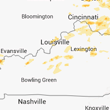
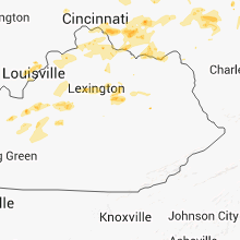
Hail Map for Thursday, July 26, 2012

Number of Impacted Households on 7/26/2012
0
Impacted by 1" or Larger Hail
0
Impacted by 1.75" or Larger Hail
0
Impacted by 2.5" or Larger Hail
Square Miles of Populated Area Impacted on 7/26/2012
0
Impacted by 1" or Larger Hail
0
Impacted by 1.75" or Larger Hail
0
Impacted by 2.5" or Larger Hail


Cities Most Affected by Hail Storms of 7/26/2012
| Hail Size | Demographics of Zip Codes Affected | ||||||
|---|---|---|---|---|---|---|---|
| City | Count | Average | Largest | Pop Density | House Value | Income | Age |
| Dayton, OH | 1 | 2.00 | 2.00 | 973 | $98k | $37.5k | 40.6 |
| Vandalia, OH | 1 | 2.00 | 2.00 | 691 | $117k | $45.6k | 41.9 |
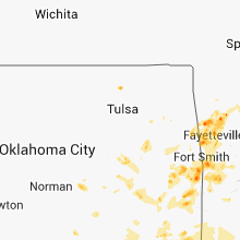
| Howe, OK | 1 | 1.75 | 1.75 | 38 | $54k | $28.3k | 37.8 |
| Red Oak, IA | 1 | 1.75 | 1.75 | 41 | $61k | $33.0k | 43.9 |
| Alma, AR | 1 | 1.75 | 1.75 | 144 | $81k | $33.9k | 36.7 |
| Birnamwood, WI | 1 | 1.75 | 1.75 | 25 | $70k | $39.9k | 40.7 |
Hail and Wind Damage Spotted on 7/26/2012
Filter by Report Type:Hail ReportsWind Reports
States Impacted
Georgia, Ohio, New York, Pennsylvania, Florida, Wisconsin, Arkansas, West Virginia, Missouri, Oklahoma, South Carolina, Illinois, Iowa, Texas, Kentucky, Montana, New Jersey, Indiana, Connecticut, Maryland, Nebraska, Virginia, UtahGeorgia
| Local Time | Report Details |
|---|---|
| 1:14 PM EDT | Gust of 010/50 knots at the kaby airpor in dougherty county GA, 75.3 miles N of Tallahassee, FL |
| 3:48 PM EDT | Trees down along highway 25 in baker county GA, 48.3 miles NNW of Tallahassee, FL |
| 4:20 PM EDT | Trees down on pondtown road north of bainbridg in decatur county GA, 43.4 miles NNW of Tallahassee, FL |
| 4:45 PM EDT | Tree down on joel poole roa in seminole county GA, 44.6 miles NW of Tallahassee, FL |
| 4:50 PM EDT | Tree down at williams road and frontage se roa in lowndes county GA, 59.7 miles SSW of Douglas, GA |
| 4:55 PM EDT | Tree down on hebrew roa in seminole county GA, 51.4 miles NW of Tallahassee, FL |
| 5:00 PM EDT | Tree down in clyattvill in lowndes county GA, 59.8 miles ENE of Tallahassee, FL |
| 5:00 PM EDT | Tree down near brooks and lowndes county borde in lowndes county GA, 54.5 miles ENE of Tallahassee, FL |
| 5:03 PM EDT | Tree down at spain ferry road and ousley roa in lowndes county GA, 55.8 miles ENE of Tallahassee, FL |
| 5:30 PM EDT | Tree down on caulie harris roa in cook county GA, 42.5 miles SW of Douglas, GA |
| 5:42 PM EDT | Tree down at intersection of milton and radford road in brooks county GA, 48.7 miles ENE of Tallahassee, FL |
| 5:44 PM EDT | Power line down along highway 133 in brooks county GA, 54.8 miles SW of Douglas, GA |
| 5:50 PM EDT | Tree down on tallokas road north of quitma in brooks county GA, 50.9 miles NE of Tallahassee, FL |
| 6:20 PM EDT | Emergency manager reports roof damage to a home located along state road 32 near the railroad crossing between ambrose and douglas. tin roof partially torn off home. ti in coffee county GA, 6.1 miles WNW of Douglas, GA |
| 6:36 PM EDT | Media relayed a report of a gas station awning downed by wind in jones county GA, 76 miles SE of Atlanta, GA |
| 7:16 PM EDT | Several trees were reported down in western upson county. time is based on radar in upson county GA, 58.5 miles S of Atlanta, GA |
| 7:20 PM EDT | Several trees reported down by broadcast media. time is based on rada in houston county GA, 89.4 miles SSE of Atlanta, GA |
| 7:25 PM EDT | A few trees and a few powerlines down on several roads near butler...including ed davis road...americus road...crossroad school road...and north davis roa in taylor county GA, 72.8 miles E of Auburn, AL |
| 7:25 PM EDT | Quarter sized hail reported near Byron, GA, 84.1 miles SSE of Atlanta, GA |
| 8:06 PM EDT | Seven trees were reported down by the media in jones county. time is based on rada in jones county GA, 71.3 miles SE of Atlanta, GA |
| 8:20 PM EDT | 6 to 10 trees reported down due to the thunderstorms. time is based on rada in bibb county GA, 74.9 miles SSE of Atlanta, GA |
| 8:30 PM EDT | The public reported three trees down in maco in bibb county GA, 76.8 miles SE of Atlanta, GA |
Ohio
| Local Time | Report Details |
|---|---|
| 1:30 PM EDT | Numerous large branches dow in trumbull county OH, 56.7 miles E of Cleveland, OH |
| 1:30 PM EDT | Numerous large limbs dow in trumbull county OH, 56.7 miles E of Cleveland, OH |
| 2:15 PM EDT | Several large trees dow in stark county OH, 45.6 miles SSE of Cleveland, OH |
| 2:32 PM EDT | Quarter sized hail reported near Youngstown, OH, 57.1 miles NW of Pittsburgh, PA |
| 2:35 PM EDT | Two trees down. time estimate in darke county OH, 60.6 miles N of Cincinnati, OH |
| 2:35 PM EDT | Quarter sized hail reported near Youngstown, OH, 51.4 miles NW of Pittsburgh, PA |
| 2:35 PM EDT | Quarter sized hail reported near Struthers, OH, 52.4 miles NW of Pittsburgh, PA |
| 2:45 PM EDT | Trees and power lines down in and around the tow in columbiana county OH, 55.4 miles NW of Pittsburgh, PA |
| 2:47 PM EDT | Trees reported down in coshocton county OH, 48.6 miles ENE of Columbus, OH |
| 2:50 PM EDT | Trees and power lines reported down along sr605 in coshocton county OH, 54.3 miles ENE of Columbus, OH |
| 2:55 PM EDT | Quarter sized hail reported near Dover, OH, 66.9 miles S of Cleveland, OH, event occurred between 240 pm 07/26/2012 and 255 pm 07/26/2012 |
| 3:00 PM EDT | Large tree down and power outtage valley road in belmont county OH, 68.7 miles WSW of Pittsburgh, PA |
| 3:15 PM EDT | Hen Egg sized hail reported near Dayton, OH, 53.7 miles NNE of Cincinnati, OH, 2 to 2.25 inch hail in this area relayed by nssl-shave |
| 3:20 PM EDT | Hen Egg sized hail reported near Vandalia, OH, 55.9 miles NNE of Cincinnati, OH, near little york road |
| 3:23 PM EDT | Quarter sized hail reported near Cincinnati, OH, 0.3 miles NE of Cincinnati, OH |
| 3:26 PM EDT | Half Dollar sized hail reported near Dayton, OH, 56.1 miles NNE of Cincinnati, OH |
| 3:26 PM EDT | Quarter sized hail reported near Springfield, OH, 43.2 miles W of Columbus, OH |
| 3:30 PM EDT | Few trees dow in summit county OH, 30.6 miles SSE of Cleveland, OH |
| 3:30 PM EDT | Trees down on grandin road in hamilton county OH, 3.3 miles ENE of Cincinnati, OH |
| 3:30 PM EDT | Trees and powerlines down in belmont county OH, 71 miles WSW of Pittsburgh, PA |
| 3:30 PM EDT | Half Dollar sized hail reported near Dayton, OH, 56.1 miles NNE of Cincinnati, OH |
| 3:32 PM EDT | Several large trees onto structures and power lines on victoria av in hamilton county OH, 4.6 miles ENE of Cincinnati, OH |
| 3:32 PM EDT | Half Dollar sized hail reported near Dayton, OH, 56.1 miles NNE of Cincinnati, OH, siding off house |
| 3:33 PM EDT | Quarter sized hail reported near New Carlisle, OH, 55.3 miles W of Columbus, OH, hail dime to quarter size |
| 3:35 PM EDT | Quarter sized hail reported near Dayton, OH, 45 miles NNE of Cincinnati, OH |
| 3:48 PM EDT | Large tree branches dow in greene county OH, 45.6 miles WSW of Columbus, OH |
| 3:50 PM EDT | Large tree down blocking road in noble county OH, 79.8 miles ESE of Columbus, OH |
| 3:50 PM EDT | Numerous trees and power lines dow in jefferson county OH, 32.3 miles W of Pittsburgh, PA |
| 3:51 PM EDT | Numerous reports of trees dow in delaware county OH, 23.7 miles N of Columbus, OH |
| 4:00 PM EDT | Extensive straight line tree damage reported north of sunbur in delaware county OH, 21.3 miles NNE of Columbus, OH |
| 4:00 PM EDT | Trees and large branches dow in clermont county OH, 19.6 miles E of Cincinnati, OH |
| 4:00 PM EDT | Ping Pong Ball sized hail reported near Columbus, OH, 9.6 miles N of Columbus, OH |
| 4:00 PM EDT | Quarter sized hail reported near Batavia, OH, 17.5 miles E of Cincinnati, OH, winds estimated to 40 mph. |
| 4:05 PM EDT | Large branches and trees dow in clermont county OH, 17.5 miles E of Cincinnati, OH |
| 4:15 PM EDT | Few trees and large limbs dow in knox county OH, 48.5 miles NE of Columbus, OH |
| 4:18 PM EDT | Several trees dow in knox county OH, 34.1 miles NE of Columbus, OH |
| 4:32 PM EDT | Quarter sized hail reported near Mt Orab, OH, 31.9 miles E of Cincinnati, OH |
| 4:38 PM EDT | Several large branches dow in franklin county OH, 8.9 miles SE of Columbus, OH |
| 4:40 PM EDT | A few trees down in northern brown county. exact locations unknown at this tim in brown county OH, 37.9 miles E of Cincinnati, OH |
| 4:47 PM EDT | Tree down on a house in fairfield county OH, 22.3 miles ESE of Columbus, OH |
| 4:49 PM EDT | Trees and power lines downed in fairfield county OH, 22.3 miles ESE of Columbus, OH |
| 4:50 PM EDT | Several large tree branches dow in highland county OH, 52.5 miles E of Cincinnati, OH |
| 4:55 PM EDT | Trees downed in licking county OH, 27.2 miles E of Columbus, OH |
| 5:00 PM EDT | Church on commercial ave sw sustained structural damage. trees were uprooted. power lines down in tuscarawas county OH, 71.2 miles S of Cleveland, OH |
| 5:08 PM EDT | A tree was downed across lapperell road. time estimated from rada in pike county OH, 57.9 miles SSW of Columbus, OH |
| 5:15 PM EDT | Tree down in holmes county OH, 65.6 miles NE of Columbus, OH |
| 5:18 PM EDT | Telephone pole dow in holmes county OH, 66.9 miles S of Cleveland, OH |
| 5:20 PM EDT | Trees and powerlines down in the town of new lexington...time estimated from radar in perry county OH, 45.6 miles ESE of Columbus, OH |
| 5:20 PM EDT | Mail boxes... stop sign... numeroud trees dow in tuscarawas county OH, 71.2 miles S of Cleveland, OH |
| 5:20 PM EDT | Trees down near route 772 in pike county OH, 66.4 miles S of Columbus, OH |
| 5:30 PM EDT | Trees down along prussia road in pike county OH, 56.7 miles S of Columbus, OH |
| 5:33 PM EDT | Several trees dow in ross county OH, 49.1 miles SSE of Columbus, OH |
| 5:33 PM EDT | Large tree down on poer lines along monnett roa in hocking county OH, 40.2 miles SE of Columbus, OH |
| 5:33 PM EDT | Large tree down on power lines along monnett roa in hocking county OH, 40.2 miles SE of Columbus, OH |
| 5:37 PM EDT | Numerous trees down from manchester to west unio in adams county OH, 56.4 miles ESE of Cincinnati, OH |
| 5:40 PM EDT | Several trees down in the town of mcconnelsville in morgan county OH, 65.5 miles ESE of Columbus, OH |
| 5:45 PM EDT | Numerous trees and power lines dow in carroll county OH, 65.6 miles W of Pittsburgh, PA |
| 5:55 PM EDT | Trees and power lines down county-wid in harrison county OH, 53.7 miles WSW of Pittsburgh, PA |
| 6:00 PM EDT | A business window was broken when a trash can blew into it in vinton county OH, 60.8 miles SSE of Columbus, OH |
| 6:00 PM EDT | Trees down on curry road in the town of mcarthur in vinton county OH, 56.8 miles SSE of Columbus, OH |
| 6:00 PM EDT | Trees down at the intersection of route 356 and us 50 in vinton county OH, 62.1 miles SE of Columbus, OH |
| 6:02 PM EDT | Trees down in wellston in jackson county OH, 63.1 miles SSE of Columbus, OH |
| 6:02 PM EDT | *** 1 inj *** tree down on a car on state route 93 north of wellston...one individual trapped in the vehicle...the driver of the vehicle was injured and transported to in jackson county OH, 62.5 miles SSE of Columbus, OH |
| 6:02 PM EDT | Tree down on a car on state route 93 north of wellston...one individual trapped in the vehicle. unknown injuries. time estimated from rada in jackson county OH, 62.5 miles SSE of Columbus, OH |
| 6:15 PM EDT | Storm damage reported in lorain county OH, 21 miles W of Cleveland, OH |
| 6:15 PM EDT | Storm damage reported in athens county OH, 66.6 miles SE of Columbus, OH |
| 6:15 PM EDT | Powerlines down in athens county OH, 66.8 miles SE of Columbus, OH |
| 6:16 PM EDT | One tree downed in clinton county OH, 44.8 miles SW of Columbus, OH |
| 6:17 PM EDT | 5 trees down on house in portage county OH, 36.4 miles SE of Cleveland, OH |
| 6:25 PM EDT | Two trees down on sand ridge road and route 681 in meigs county OH, 62.5 miles NNW of Charleston, WV |
| 6:30 PM EDT | Several large branches in mahoning county OH, 52.6 miles SE of Cleveland, OH |
| 6:37 PM EDT | Large branches broke in washington county OH, 74 miles N of Charleston, WV |
| 6:48 PM EDT | Trees and powerlines down in columbiana county OH, 39.3 miles NW of Pittsburgh, PA |
| 6:52 PM EDT | Several trees dow in cuyahoga county OH, 5.5 miles ESE of Cleveland, OH |
| 7:16 PM EDT | Tree down on dunlap road near us 62. time estimated from rada in highland county OH, 47.8 miles E of Cincinnati, OH |
| 7:28 PM EDT | Trees down on sr 124 and sr 77 in pike county OH, 61 miles SSW of Columbus, OH |
| 7:30 PM EDT | Tree down on sr 286 about a half mile west of sr 134. time estimated from rada in highland county OH, 35.2 miles E of Cincinnati, OH |
| 7:30 PM EDT | Tree down near sr 321 and wildcat road. also a tree down on taylorsville road. time estimated from rada in highland county OH, 41.9 miles E of Cincinnati, OH |
New York
| Local Time | Report Details |
|---|---|
| 1:30 PM EDT | Tree on wires in chautauqua county NY, 61.9 miles SW of Buffalo, NY |
| 1:40 PM EDT | Tree down on wires in chautauqua county NY, 59.7 miles SW of Buffalo, NY |
| 2:04 PM EDT | Tree blocking roadway in cattaraugus county NY, 50.3 miles S of Buffalo, NY |
| 2:04 PM EDT | Tree down on wires in cattaraugus county NY, 43 miles SSE of Buffalo, NY |
| 2:21 PM EDT | Tree down in cattaraugus county NY, 50.3 miles S of Buffalo, NY |
| 2:25 PM EDT | Trees down in allegany county NY, 51.5 miles SE of Buffalo, NY |
| 2:32 PM EDT | Tree on power lines in cattaraugus county NY, 61.1 miles SSE of Buffalo, NY |
| 2:34 PM EDT | Trees and wires down in allegany county NY, 59.6 miles SE of Buffalo, NY |
| 2:36 PM EDT | Trees down blocking road in cattaraugus county NY, 62.5 miles SSE of Buffalo, NY |
| 2:40 PM EDT | Trees and wires down in allegany county NY, 63.1 miles SE of Buffalo, NY |
| 2:40 PM EDT | Large limbs down and awning ripped off building in cattaraugus county NY, 60.1 miles SSE of Buffalo, NY |
| 2:47 PM EDT | Tree blocking roadway in cattaraugus county NY, 64.5 miles SSE of Buffalo, NY |
| 2:55 PM EDT | Trees and wires down in allegany county NY, 66.9 miles SSE of Buffalo, NY |
| 2:57 PM EDT | Trees and wires down in allegany county NY, 71 miles SE of Buffalo, NY |
| 3:03 PM EDT | Tree fell on vehicle in allegany county NY, 73.8 miles SE of Buffalo, NY |
| 3:15 PM EDT | Trees and wires down in allegany county NY, 81.3 miles SE of Buffalo, NY |
| 3:23 PM EDT | Powerlines down in woodhull blocking both lanes of traffi in steuben county NY, 91.7 miles NNE of State College, PA |
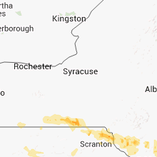
| 3:32 PM EDT | Tree down blocking road in steuben county NY, 85.2 miles SW of Syracuse, NY |
| 3:35 PM EDT | Numerous trees down on house in steuben county NY, 85.2 miles SW of Syracuse, NY |
| 3:35 PM EDT | Macroburst affected areas from south of corning to south of elmira. significant tree damage occurred with this system. estimated time of the thunderstorm that produced in steuben county NY, 77.6 miles SW of Syracuse, NY |
| 3:40 PM EDT | Numerous trees down in steuben county NY, 82.1 miles SW of Syracuse, NY |
| 3:40 PM EDT | Trees down. several on house in steuben county NY, 82.1 miles SW of Syracuse, NY |
| 3:42 PM EDT | Numerous trees down. many on house in steuben county NY, 82.4 miles SSW of Syracuse, NY |
| 3:45 PM EDT | Numerous trees down around corning community colleg in steuben county NY, 78.7 miles SW of Syracuse, NY |
| 4:02 PM EDT | Trees and power lines down. also small hail in chemung county NY, 74 miles SSW of Syracuse, NY |
| 4:14 PM EDT | Missing roofs and porches on some houses. numerous trees and power lines dow in tioga county NY, 60.1 miles NW of Scranton, PA |
| 4:14 PM EDT | Snapped many trees and tree branches along with lifting a roof off of an open pole barn. winds at this location were estimated to be between 60 and 80 mph. as the downb in tioga county NY, 60.1 miles NW of Scranton, PA |
| 4:20 PM EDT | Trees down between nichols and lounsberry in tioga county NY, 55.8 miles NW of Scranton, PA |
| 4:28 PM EDT | Small trees down between owego and campville on 17c in tioga county NY, 52.7 miles NNW of Scranton, PA |
| 4:28 PM EDT | Branches down in tioga county NY, 56.8 miles NNW of Scranton, PA |
| 4:35 PM EDT | Numerous trees down. some large trees snapped in hal in tioga county NY, 56.8 miles NNW of Scranton, PA |
| 4:40 PM EDT | Continued 55-60 mph for 10 minutes. also dime sized hail in broome county NY, 51.9 miles NNW of Scranton, PA |
| 4:40 PM EDT | Numerous trees down between campville and endicott in broome county NY, 51.9 miles NNW of Scranton, PA |
| 4:40 PM EDT | 12 tree limbs snapped off from tops of trees along route 434 - the vestal parkway. in broome county NY, 50.4 miles NNW of Scranton, PA |
| 4:40 PM EDT | Large tree broken off at base... crushing a shed on verna drive. power lines and several large trees down on torrance ave... hillside drive... harding av in broome county NY, 50.4 miles NNW of Scranton, PA |
| 4:40 PM EDT | Large tree down blocing one lane of state route 26 near hazel drive in broome county NY, 50.4 miles NNW of Scranton, PA |
| 4:40 PM EDT | Numerous tree limbs down on route 434 and side roads in broome county NY, 50.4 miles NNW of Scranton, PA |
| 4:41 PM EDT | Trees down on lincoln street with people trapped inside home in broome county NY, 50.4 miles NNW of Scranton, PA |
| 4:45 PM EDT | Numerous trees and wires down on hawleton road in the town of binghamton and also in the city of binghamton in broome county NY, 49.3 miles NNW of Scranton, PA |
| 4:45 PM EDT | Numerous large trees down on south mountai in broome county NY, 47.3 miles NNW of Scranton, PA |
| 4:50 PM EDT | Trees down in broome county NY, 43.4 miles N of Scranton, PA |
| 4:50 PM EDT | Trees downs. power lines also down from high winds. winds estimated at 60 mp in broome county NY, 50.4 miles NNW of Scranton, PA |
| 5:06 PM EDT | Trees dow in broome county NY, 46.2 miles N of Scranton, PA |
| 5:25 PM EDT | Numerous trees down throughout the hancock community in delaware county NY, 42.1 miles NNE of Scranton, PA |
| 5:55 PM EDT | Numerous trees down in and around the city of monticell in sullivan county NY, 53 miles ENE of Scranton, PA |
| 6:12 PM EDT | Trees down in ulster county NY, 66.3 miles ENE of Scranton, PA |
| 6:18 PM EDT | Tree down in ulster county NY, 70.3 miles ENE of Scranton, PA |
| 6:24 PM EDT | Trees down in ulster county NY, 71.6 miles ENE of Scranton, PA |
| 6:30 PM EDT | Storm damage reported in orange county NY, 56 miles N of Brooklyn, NY |
| 6:31 PM EDT | Large tree limb down on wires and hous in orange county NY, 55.7 miles N of Brooklyn, NY |
| 6:36 PM EDT | Trees down in dutchess county NY, 55.7 miles N of Brooklyn, NY |
| 6:36 PM EDT | Tree on house on south main stree in orange county NY, 44.5 miles NNW of Brooklyn, NY |
| 6:38 PM EDT | Trees down in dutchess county NY, 62.7 miles N of Brooklyn, NY |
| 6:49 PM EDT | Trees down in dutchess county NY, 61.8 miles NNE of Brooklyn, NY |
| 6:54 PM EDT | Scattered trees down in brewste in putnam county NY, 52.5 miles NNE of Brooklyn, NY |
| 6:59 PM EDT | Storm damage reported in westchester county NY, 31.4 miles N of Brooklyn, NY |
| 7:00 PM EDT | Multiple trees down across mahopac. specifically one tree down on the corner of richard and tanya lane in putnam county NY, 48.5 miles NNE of Brooklyn, NY |
| 7:00 PM EDT | Quarter sized hail reported near Carmel, NY, 52.1 miles NNE of Brooklyn, NY |
| 7:14 PM EDT | Tree down on wires along banksville rd in westchester county NY, 35.1 miles NNE of Brooklyn, NY |
| 7:15 PM EDT | Multiple trees down around lake carmel in putnam county NY, 55.5 miles NNE of Brooklyn, NY |
| 7:15 PM EDT | Multiple trees and wires down around town in westchester county NY, 46.7 miles NNE of Brooklyn, NY |
| 7:20 PM EDT | Tree down on car on route 22 in westchester county NY, 47.3 miles NNE of Brooklyn, NY |
| 7:45 PM EDT | 65 ft tree split in two on arthur kill rd in richmond county NY, 18.6 miles SW of Brooklyn, NY |
| 8:00 PM EDT | Tree down near locust valley...reported by long island railroa in nassau county NY, 24.7 miles ENE of Brooklyn, NY |
| 8:15 PM EDT | 65 ft tree split in two on arthur kill rd in richmond county NY, 18.6 miles SW of Brooklyn, NY |
Pennsylvania
| Local Time | Report Details |
|---|---|
| 1:34 PM EDT | Trees and large limbs dow in erie county PA, 85.1 miles ENE of Cleveland, OH |
| 1:50 PM EDT | Numeropus trees down from sandy lake to pymatuning lak in mercer county PA, 64.9 miles E of Cleveland, OH |
| 2:00 PM EDT | Trees and wires dow in warren county PA, 66.8 miles SSW of Buffalo, NY |
| 2:00 PM EDT | Many trees down in crawford county PA, 73.7 miles E of Cleveland, OH |
| 2:30 PM EDT | Widespread trees down throughout the count in venango county PA, 66.2 miles N of Pittsburgh, PA |
| 2:30 PM EDT | Straight line thunderstorm wind event began at lat 41.46934 lon -79.53997 ending at lat 41.46857 lon -79.53960. 10 trees down including one large oak. maximum estimated in venango county PA, 74.1 miles NNE of Pittsburgh, PA |
| 2:30 PM EDT | Numerous trees and power lines down along route 62 in president tw in venango county PA, 71.7 miles NNE of Pittsburgh, PA |
| 2:35 PM EDT | Numerous large trees and power lines dow in mckean county PA, 71 miles S of Buffalo, NY |
| 2:56 PM EDT | Trees reported down near smethpor in mckean county PA, 76.3 miles NNW of State College, PA |
| 2:58 PM EDT | Numerous large trees and power lines down through smethport are in mckean county PA, 76.3 miles NNW of State College, PA |
| 3:00 PM EDT | Large tree down and power outage valley road in lawrence county PA, 43 miles NNW of Pittsburgh, PA |
| 3:00 PM EDT | Tree down ellwood road in lawrence county PA, 43 miles NNW of Pittsburgh, PA |
| 3:00 PM EDT | Trees and lines down nashua roa in lawrence county PA, 43 miles NNW of Pittsburgh, PA |
| 3:05 PM EDT | Multiple large trees blown down in barnett twp... near sr 899 and sr 36 crossin in jefferson county PA, 74.8 miles WNW of State College, PA |
| 3:05 PM EDT | Numerous trees blown down... partially blocking sr 89 in forest county PA, 78.1 miles NE of Pittsburgh, PA |
| 3:08 PM EDT | Large trees down in roulett in potter county PA, 69.2 miles NNW of State College, PA |
| 3:15 PM EDT | Numerous trees and wires down area-wid in elk county PA, 63.1 miles NW of State College, PA |
| 3:15 PM EDT | Trees down on house. person trappe in clarion county PA, 75.1 miles NNE of Pittsburgh, PA |
| 3:20 PM EDT | Large tree blown down on 7th ave ex in jefferson county PA, 57.9 miles WNW of State College, PA |
| 3:20 PM EDT | Numerous trees and wires down across the are in elk county PA, 64.3 miles NW of State College, PA |
| 3:25 PM EDT | Wall of home partially caved in...roof blown off barn in beaver county PA, 26 miles NW of Pittsburgh, PA |
| 3:25 PM EDT | Trees and wires reported down across the are in elk county PA, 57.1 miles NW of State College, PA |
| 3:30 PM EDT | Trees reported down on route 87 in potter county PA, 59.6 miles NNW of State College, PA |
| 3:30 PM EDT | Tree down across a road near harrison valle in potter county PA, 78.4 miles N of State College, PA |
| 3:30 PM EDT | Multiple trees and power lines blown dow in jefferson county PA, 63.3 miles NE of Pittsburgh, PA |
| 3:37 PM EDT | Large tree limbs reported down in emporiu in cameron county PA, 53.2 miles NNW of State College, PA |
| 3:38 PM EDT | Trees and power lines dow in beaver county PA, 23.9 miles NW of Pittsburgh, PA |
| 3:40 PM EDT | Numerous trees and power lines dow in jefferson county PA, 68.6 miles WNW of State College, PA |
| 3:48 PM EDT | Trees and wires down numerous locations from evans city northwar in butler county PA, 23.1 miles N of Pittsburgh, PA |
| 3:50 PM EDT | Trees reported down near lawrencevill in tioga county PA, 86.2 miles WNW of Scranton, PA |
| 3:55 PM EDT | Numerous trees and wires reported down in vicinity of tioga and hammond lake in tioga county PA, 83.7 miles WNW of Scranton, PA |
| 4:00 PM EDT | Trees and wires down fawn tw in allegheny county PA, 17.9 miles NE of Pittsburgh, PA |
| 4:00 PM EDT | Large tree reported dow in tioga county PA, 66.6 miles NNE of State College, PA |
| 4:00 PM EDT | Large tree down on burtner roa in allegheny county PA, 18.9 miles NE of Pittsburgh, PA |
| 4:00 PM EDT | Numerous trees and large branches dow in allegheny county PA, 18.9 miles NE of Pittsburgh, PA |
| 4:00 PM EDT | Numerous trees and power lines dow in jefferson county PA, 59 miles W of State College, PA |
| 4:10 PM EDT | Trees and wires down near grampia in clearfield county PA, 40.9 miles WNW of State College, PA |
| 4:10 PM EDT | Trees and power lines down intersection route 228 and 356. tractor trailer tangled in power line in butler county PA, 24.6 miles NE of Pittsburgh, PA |
| 4:10 PM EDT | Trees and wires down in the sayre and athens area of northern bradford county in bradford county PA, 59.8 miles NW of Scranton, PA |
| 4:15 PM EDT | Numerous trees and power lines dow in armstrong county PA, 22.7 miles NE of Pittsburgh, PA |
| 4:19 PM EDT | Heavy rain and dime sized hail also reporte in bradford county PA, 55.4 miles WNW of Scranton, PA |
| 4:19 PM EDT | Storm damage reported in clinton county PA, 32.1 miles NE of State College, PA |
| 4:20 PM EDT | Trees and powerlines down throughout the area in allegheny county PA, 13.7 miles WNW of Pittsburgh, PA |
| 4:25 PM EDT | Trees dow in lycoming county PA, 41.7 miles NE of State College, PA |
| 4:25 PM EDT | Trees reported across clinton count in clinton county PA, 32.1 miles NE of State College, PA |
| 4:26 PM EDT | Trees down across route 1 in lycoming county PA, 62.5 miles NE of State College, PA |
| 4:30 PM EDT | Rte 410. trees reported down and shingles and downspouts torn off hous in jefferson county PA, 59 miles W of State College, PA |
| 4:35 PM EDT | Numerous large tree limbs reported down near linde in lycoming county PA, 48.2 miles NE of State College, PA |
| 4:40 PM EDT | Trees and wires down in cambria county PA, 31.5 miles W of State College, PA |
| 4:43 PM EDT | Trees down in allenwood are in union county PA, 54.3 miles ENE of State College, PA |
| 4:43 PM EDT | Roof blown off a building at penn colleg in lycoming county PA, 53.7 miles NE of State College, PA |
| 4:45 PM EDT | A gust to 59 mph was recorded at the williamsport airport aso in lycoming county PA, 58 miles ENE of State College, PA |
| 4:45 PM EDT | Roof blown off a house. building under construction blown dow in susquehanna county PA, 31.1 miles NNW of Scranton, PA |
| 4:48 PM EDT | Multiple trees...large groups of trees down... trees down on homes and barns. also tops of trees of in susquehanna county PA, 26.5 miles NNW of Scranton, PA |
| 4:48 PM EDT | Trees dow in cambria county PA, 49 miles W of State College, PA |
| 4:50 PM EDT | Door ripped off of house on main street in munc in lycoming county PA, 60.5 miles WSW of Scranton, PA |
| 4:50 PM EDT | Many large trees down in susquehanna county PA, 32.6 miles N of Scranton, PA |
| 4:53 PM EDT | Just north of route 6 and 87 interchange...multiple trees down. 3 large loading dock doors blown in on proctor and gamble warehous in wyoming county PA, 24.5 miles NW of Scranton, PA |
| 4:54 PM EDT | Quarter sized hail reported near Montrose, PA, 31.1 miles NNW of Scranton, PA |
| 4:55 PM EDT | Large tree limbs and small trees dow in centre county PA, 8.7 miles WSW of State College, PA |
| 5:00 PM EDT | Trees and powerlines down in westmoreland county PA, 15 miles NE of Pittsburgh, PA |
| 5:02 PM EDT | Few trees and large limbs down along greens valley r in centre county PA, 9.6 miles ENE of State College, PA |
| 5:05 PM EDT | Quarter sized hail reported near Irwin, PA, 17.7 miles ESE of Pittsburgh, PA |
| 5:10 PM EDT | Trees down county-wide in westmoreland county PA, 30.6 miles E of Pittsburgh, PA |
| 5:10 PM EDT | Nws storm survey team has determined that tree and structural damage in this area was consistent with a microburst. several locations had significant tree damage and sp in susquehanna county PA, 25.8 miles N of Scranton, PA |
| 5:15 PM EDT | Trees and wires down in columbia county PA, 39.1 miles SW of Scranton, PA |
| 5:15 PM EDT | Tree down on a hous in blair county PA, 37.5 miles SW of State College, PA |
| 5:15 PM EDT | Quarter sized hail reported near Berwick, PA, 39.1 miles SW of Scranton, PA, quarter sized hail reported in berwick. |
| 5:16 PM EDT | Trees dow in cambria county PA, 50.3 miles WSW of State College, PA |
| 5:20 PM EDT | Damage throughout the county... but most significant in the southern part. many trees and power lines down. two tractor trailers blown over on interstate 80. emergency in luzerne county PA, 35.6 miles SSW of Scranton, PA |
| 5:30 PM EDT | Storm damage reported in indiana county PA, 53.6 miles E of Pittsburgh, PA |
| 5:30 PM EDT | Trees dow in greene county PA, 37.2 miles S of Pittsburgh, PA |
| 5:33 PM EDT | Trees down in luzerne county PA, 32.2 miles SSW of Scranton, PA |
| 5:37 PM EDT | Large tree limbs reported dow in cambria county PA, 55.9 miles E of Pittsburgh, PA |
| 5:38 PM EDT | Nws storm survey teams have confirmed downbust winds of approximately 100 mph along east foothills drive in butler township... pa. downburst winds resulted in numerous in luzerne county PA, 32.6 miles SSW of Scranton, PA |
| 5:42 PM EDT | Trees down. time doppler radar estimate in pike county PA, 34.7 miles E of Scranton, PA |
| 5:42 PM EDT | Tree down in matamoras. time doppler radar estimate in pike county PA, 50 miles E of Scranton, PA |
| 5:50 PM EDT | Trees down county-wide in fayette county PA, 39.9 miles SSE of Pittsburgh, PA |
| 5:56 PM EDT | Trees and power lines down in carbon county PA, 42.2 miles S of Scranton, PA |
| 6:00 PM EDT | Trees and powerlines down in westmoreland county PA, 44.8 miles E of Pittsburgh, PA |
| 6:00 PM EDT | Trees and wires down across upper dauphin count in dauphin county PA, 63.1 miles ESE of State College, PA |
| 6:06 PM EDT | Tree down in matamoras. time doppler radar estimate in pike county PA, 50 miles E of Scranton, PA |
| 6:07 PM EDT | Large branches down in westmoreland county PA, 18.3 miles ESE of Pittsburgh, PA |
| 6:08 PM EDT | Trees down across northern bedford count in bedford county PA, 47.2 miles SW of State College, PA |
| 6:10 PM EDT | Trees and wires reported down across northern somerset count in somerset county PA, 63.3 miles ESE of Pittsburgh, PA |
| 6:13 PM EDT | Storm damage reported in northampton county PA, 46 miles SSE of Scranton, PA |
| 6:15 PM EDT | Trees dow in bedford county PA, 62.6 miles SW of State College, PA |
| 6:20 PM EDT | Numerous trees dow in somerset county PA, 46.8 miles SE of Pittsburgh, PA |
| 6:22 PM EDT | Trees down in northampton county PA, 49 miles SSE of Scranton, PA |
| 6:27 PM EDT | Trees down on wire in somerset county PA, 55.3 miles SE of Pittsburgh, PA |
| 6:29 PM EDT | Trees and wires down in fairview tw in york county PA, 62.9 miles NNW of Baltimore, MD |
| 6:45 PM EDT | At least 1 tractor trailer blown over on i-80 at pa nj state lin in monroe county PA, 40.2 miles SE of Scranton, PA |
| 6:45 PM EDT | Trees and powerlines down throughout elizabeth township in allegheny county PA, 12.9 miles SSE of Pittsburgh, PA |
| 6:48 PM EDT | Trees down in conoy tw in lancaster county PA, 55.2 miles N of Baltimore, MD |
| 6:48 PM EDT | Trees down in west cocalico tw in lancaster county PA, 69.4 miles NNE of Baltimore, MD |
| 6:50 PM EDT | Wires down across roadway in clay tw in lancaster county PA, 67.1 miles NNE of Baltimore, MD |
| 7:00 PM EDT | Trees and powerlines down in fayette county PA, 27.4 miles SSE of Pittsburgh, PA |
| 7:04 PM EDT | Storm damage reported in chester county PA, 73 miles NE of Baltimore, MD |
| 7:05 PM EDT | Trees and lines down in hempfield township in westmoreland county PA, 26.2 miles ESE of Pittsburgh, PA |
| 7:07 PM EDT | Large branches down in westmoreland county PA, 18.3 miles ESE of Pittsburgh, PA |
| 7:10 PM EDT | Trees and powerlines down throughout county in indiana county PA, 54.4 miles ENE of Pittsburgh, PA |
| 7:12 PM EDT | Trees and wires down in strasburg tw in lancaster county PA, 52.6 miles NNE of Baltimore, MD |
| 7:15 PM EDT | Trees down in the town of connellsville in fayette county PA, 36 miles SE of Pittsburgh, PA |
| 7:15 PM EDT | Trees and powerlines down in dawson borough and surrounding areas in fayette county PA, 32.2 miles SSE of Pittsburgh, PA |
| 7:15 PM EDT | Large tree limbs dow in lancaster county PA, 50.9 miles NNE of Baltimore, MD |
| 7:15 PM EDT | Utility poles down in springettsbury tw in york county PA, 49.1 miles N of Baltimore, MD |
| 8:00 PM EDT | Trees and wires dow in york county PA, 35 miles N of Baltimore, MD |
Florida
| Local Time | Report Details |
|---|---|
| 2:14 PM CDT | Eglin afb...kvps...measured a peak wind gust of 62 mph. pea size hail was also reporte in okaloosa county FL, 12.7 miles WNW of Miramar Beach, FL |
| 2:24 PM CDT | 46kt/53 mph wind gust reported by asos in okaloosa county FL, 12.5 miles NW of Miramar Beach, FL |
| 3:58 PM CDT | 64 mph wind gust measured by asos at marianna airpor in jackson county FL, 61.5 miles WNW of Tallahassee, FL |
| 3:58 PM CDT | 64 mph wind gust measured by asos at marianna airpor in jackson county FL, 59.9 miles WNW of Tallahassee, FL |
| 4:00 PM CDT | A couple trees down near greenwood on highway 16 in jackson county FL, 60.2 miles WNW of Tallahassee, FL |
Wisconsin
| Local Time | Report Details |
|---|---|
| 2:29 PM CDT | 4 inch diameter tree branch down with heavy rain at swan road near bu in dodge county WI, 45.1 miles NE of Madison, WI |
| 10:08 PM CDT | Golf Ball sized hail reported near Birnamwood, WI, 50.1 miles SSE of Rhinelander, WI, relayed by sheriffs dept near hwy 45 and church rd |
Arkansas
| Local Time | Report Details |
|---|---|
| 2:31 PM CDT | Trees down on rambo road east of roger in benton county AR, 69.9 miles NNE of Fort Smith, AR |
| 2:50 PM CDT | 5news arkansas viever reported 60-70mph winds with passing thunderstor in washington county AR, 57.9 miles NNE of Fort Smith, AR |
| 3:08 PM CDT | Quarter sized hail reported near Fayetteville, AR, 51.8 miles NNE of Fort Smith, AR, at garland exit of i 540 |
| 3:08 PM CDT | Quarter sized hail reported near Fayetteville, AR, 48.8 miles NNE of Fort Smith, AR, reported at sams club and the fayetteville autopark |
| 3:17 PM CDT | Quarter sized hail reported near Fayetteville, AR, 48.8 miles NNE of Fort Smith, AR |
| 3:25 PM CDT | Tree down near the intersection of maple and mission in washington county AR, 48.8 miles NNE of Fort Smith, AR |
| 3:26 PM CDT | Trees down at state highway 45 and 30 in washington county AR, 58.1 miles NNE of Fort Smith, AR |
| 3:35 PM CDT | Large tree limbs down...winds estimated at 70 mp in washington county AR, 48.3 miles NNE of Fort Smith, AR |
| 4:34 PM CDT | Power lines and trees over the road near lake fort smith state par in crawford county AR, 23.7 miles NE of Fort Smith, AR |
| 4:47 PM CDT | Storm damage reported in sebastian county AR, 1.3 miles ENE of Fort Smith, AR |
| 4:47 PM CDT | Storm damage reported in crawford county AR, 11.2 miles ENE of Fort Smith, AR |
| 4:47 PM CDT | Golf Ball sized hail reported near Alma, AR, 11.2 miles ENE of Fort Smith, AR |
| 4:48 PM CDT | Numerous trees and some power lines were blown dow in pope county AR, 66.3 miles E of Fort Smith, AR |
| 4:49 PM CDT | Trees down in south fort smith in sebastian county AR, 1.3 miles ENE of Fort Smith, AR |
| 5:05 PM CDT | Trees and power lines were blown dow in izard county AR, 95.6 miles N of Little Rock, AR |
| 5:05 PM CDT | Trees and power lines were blown down. power outages occurred in the southwest part of calico rock. some of the power has since been restored. one lane of arkansas 223 in izard county AR, 95.6 miles N of Little Rock, AR |
| 5:07 PM CDT | A tree fell on a power lin in baxter county AR, 73.1 miles SE of Springfield, MO |
| 5:11 PM CDT | Trees down in sebastian county AR, 14.6 miles SE of Fort Smith, AR |
| 5:20 PM CDT | Trees dow in franklin county AR, 21.3 miles E of Fort Smith, AR |
| 6:13 PM CDT | An unoccupied house had roof damag in conway county AR, 48.5 miles NNW of Little Rock, AR |
| 6:26 PM CDT | Trees down throughout randolph county...some blocking roadways in randolph county AR, 93.1 miles S of Salem, MO |
| 6:40 PM CDT | Trees down county wide...some blocking roadways in randolph county AR, 87.8 miles SSE of Salem, MO |
| 6:50 PM CDT | Several trees were blown down in harvey. power outages occurred around harvey and nol in scott county AR, 51.7 miles SE of Fort Smith, AR |
| 7:00 PM CDT | Trees down county wide... some blocking roadways in randolph county AR, 95.3 miles NNW of Memphis, TN |
| 7:20 PM CDT | Large tree down on fence and house in central paragould in greene county AR, 67.9 miles NNW of Memphis, TN |
| 7:40 PM CDT | Trees down on power lines on the 1700 block of church street... power outages in south jonesboro in craighead county AR, 58.7 miles NW of Memphis, TN |
| 7:44 PM CDT | Highway signs blown into roadway on hwy 18 east of jonesboro in the black oak area in craighead county AR, 57.3 miles NW of Memphis, TN |
| 8:00 PM CDT | Large tree down blocking roadway near the 1100 block of pomona drive in north east jonesboro in craighead county AR, 58.7 miles NW of Memphis, TN |
| 8:13 PM CDT | Wind gust was measured at the newport airpor in jackson county AR, 75 miles WNW of Memphis, TN |
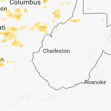
West Virginia
| Local Time | Report Details |
|---|---|
| 4:00 PM EDT | Trees dow in hancock county WV, 32.6 miles W of Pittsburgh, PA |
| 4:00 PM EDT | Trees dow in hancock county WV, 30.8 miles W of Pittsburgh, PA |
| 5:15 PM EDT | Trees dow in wetzel county WV, 60.5 miles SSW of Pittsburgh, PA |
| 5:36 PM EDT | Two trees down in the town of middlebourne. time estimated from rada in tyler county WV, 69.2 miles NW of Elkins, WV |
| 6:15 PM EDT | Large trees dow in marshall county WV, 47 miles SW of Pittsburgh, PA |
| 6:30 PM EDT | Trees and wires down throughout county in marion county WV, 41.5 miles NNW of Elkins, WV |
| 7:00 PM EDT | Numerous trees dow in monongalia county WV, 52.1 miles NNW of Elkins, WV |
| 7:00 PM EDT | Trees down around servia in braxton county WV, 41.2 miles ENE of Charleston, WV |
| 7:00 PM EDT | Tree down into power lines in the town of st. marys in pleasants county WV, 76.2 miles NNE of Charleston, WV |
| 7:00 PM EDT | Trees down on route 50 in doddridge county WV, 49.1 miles WNW of Elkins, WV |
| 7:05 PM EDT | Trees dow in preston county WV, 52.8 miles NNE of Elkins, WV |
| 7:15 PM EDT | Tress down county-wid in marion county WV, 41.5 miles NNW of Elkins, WV |
| 7:20 PM EDT | Trees down into power lines on route 119 in grafton in taylor county WV, 30.2 miles NNW of Elkins, WV |
| 7:20 PM EDT | Trees and power lines down in shinnston in harrison county WV, 40.4 miles NW of Elkins, WV |
| 7:20 PM EDT | Tree down on farnum road in the town of hepzibah in harrison county WV, 38.8 miles NW of Elkins, WV |
| 7:30 PM EDT | Trees dow in monongalia county WV, 39.9 miles N of Elkins, WV |
| 7:45 PM EDT | Two trees down on one residence in grantsville...1 tree on the house...1 tree on power lines in calhoun county WV, 49.3 miles NE of Charleston, WV |
| 7:45 PM EDT | Power lines down near spencer in roane county WV, 34.5 miles NNE of Charleston, WV |
| 7:54 PM EDT | Trees down blocking the road on route 38 near route 92 in the clemtown are in barbour county WV, 18.8 miles NNW of Elkins, WV |
| 7:58 PM EDT | Large tree fell onto route 46 in fort ashb in mineral county WV, 70 miles NE of Elkins, WV |
| 7:58 PM EDT | Trees down near rt 46 and georges run rd in mineral county WV, 67.9 miles NE of Elkins, WV |
| 8:00 PM EDT | 2 trees down on top of power lines...trees are on fire in barbour county WV, 8.1 miles NW of Elkins, WV |
| 8:05 PM EDT | Trees down around servia in braxton county WV, 41.2 miles ENE of Charleston, WV |
| 8:05 PM EDT | Trees down in braxton county WV, 41.9 miles ENE of Charleston, WV |
| 8:15 PM EDT | Twigs or small branches broke in braxton county WV, 45.9 miles WSW of Elkins, WV |
| 8:20 PM EDT | Power lines down in putnam county WV, 17.2 miles WNW of Charleston, WV |
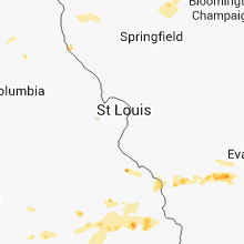
Missouri
| Local Time | Report Details |
|---|---|
| 3:03 PM CDT | Empty tractor trailer reported blown over. dime sized hail also reporte in wright county MO, 49.1 miles E of Springfield, MO |
| 3:30 PM CDT | Several trees and power lines blown down near highway 65 and highway 24 in taney county MO, 39.4 miles S of Springfield, MO |
| 3:50 PM CDT | Six inch diameter limbs down and nickel size hail in reynolds county MO, 38.6 miles SE of Salem, MO |
| 3:53 PM CDT | Damage to concrete business in south cape girardea in cape girardeau county MO, 0.6 miles NNW of Cape Girardeau, MO |
| 4:00 PM CDT | Uprooted trees and downed power lines in tow in scott county MO, 10.6 miles SW of Cape Girardeau, MO |
| 4:08 PM CDT | Power line pole blown dow in howell county MO, 64.9 miles SSW of Salem, MO |
| 4:10 PM CDT | A tree was blown down on a roadway near highway 6 in howell county MO, 64.2 miles SSW of Salem, MO |
| 4:50 PM CDT | Fifteen inch tree reported down across road in tow in oregon county MO, 65.7 miles S of Salem, MO |
| 5:30 PM CDT | Downed trees and power lines. half of community without power. winds estimated 60 to 70 mp in wayne county MO, 51.3 miles WSW of Cape Girardeau, MO |
| 5:55 PM CDT | Parked semi trailers blown ove in stoddard county MO, 46.5 miles SW of Cape Girardeau, MO |
Oklahoma
| Local Time | Report Details |
|---|---|
| 3:10 PM CDT | Winds destroyed an above ground pool near highway 69 on the west side of muskogee. time estimated by rada in muskogee county OK, 42.8 miles SE of Tulsa, OK |
| 3:35 PM CDT | Storm damage reported in johnston county OK, 47 miles WSW of Atoka, OK |
| 3:57 PM CDT | Roof damage to a house...trees down... and a mobile home moved 2 fee in haskell county OK, 35 miles WSW of Fort Smith, AR |
| 4:35 PM CDT | Quarter sized hail reported near Pocola, OK, 11.8 miles SSW of Fort Smith, AR |
| 4:40 PM CDT | Power lines down on highway 9 in le flore county OK, 5.6 miles SW of Fort Smith, AR |
| 4:49 PM CDT | Storm damage reported in le flore county OK, 11.2 miles SSW of Fort Smith, AR |
| 4:52 PM CDT | Large tree limbs downed in le flore county OK, 15.6 miles WSW of Fort Smith, AR |
| 5:25 PM CDT | Large trees blown in hughes county OK, 49.6 miles NNW of Atoka, OK |
| 5:30 PM CDT | Tree down in le flore county OK, 32.4 miles SSW of Fort Smith, AR |
| 5:35 PM CDT | Golf Ball sized hail reported near Howe, OK, 32.4 miles SSW of Fort Smith, AR |
| 5:42 PM CDT | Storm damage reported in bryan county OK, 33.5 miles SSW of Atoka, OK |
| 5:45 PM CDT | Durant police department reports power lines downed and at least 6 trees downed on roadways or house in bryan county OK, 30.9 miles SSW of Atoka, OK |
| 5:46 PM CDT | Wind 19030g63k in bryan county OK, 32.6 miles SSW of Atoka, OK |
| 5:55 PM CDT | Numerous trees down in c in bryan county OK, 32.3 miles SSW of Atoka, OK |
| 6:42 PM CDT | Several large tree limbs downed in pittsburg county OK, 50.7 miles NNE of Atoka, OK |
| 6:56 PM CDT | Power lines down in pittsburg county OK, 49.4 miles NNE of Atoka, OK |
| 7:00 PM CDT | Storm damage reported in choctaw county OK, 43.8 miles SE of Atoka, OK |
| 7:30 PM CDT | Large tree limbs downe in okmulgee county OK, 47.8 miles S of Tulsa, OK |
| 7:32 PM CDT | Roof damage and trees dow in okmulgee county OK, 48.9 miles S of Tulsa, OK |
| 7:32 PM CDT | Power lines downe in latimer county OK, 48.4 miles NE of Atoka, OK |
| 7:50 PM CDT | Several large trees down...two on homes near raymond gary state par in choctaw county OK, 55.9 miles ESE of Atoka, OK |
| 7:55 PM CDT | Tree down on a house in the lake pine retreat are in mccurtain county OK, 50.3 miles WNW of Nashville, AR |
| 7:55 PM CDT | Tree and limb damage around the stidham are in mcintosh county OK, 56.2 miles SSE of Tulsa, OK |
| 8:30 PM CDT | Tree down across a roadway near broken bow lak in mccurtain county OK, 50.3 miles WNW of Nashville, AR |
South Carolina
| Local Time | Report Details |
|---|---|
| 4:40 PM EDT | The hampton county warning point reported trees and powerlines were blown down throughout the city of estill. some streets impacted by fallen trees include 3rd street in hampton county SC, 47.6 miles N of Savannah, GA |
Illinois
| Local Time | Report Details |
|---|---|
| 3:40 PM CDT | Quarter sized hail reported near Carbondale, IL, 31.5 miles NE of Cape Girardeau, MO, quarter size hail reported south of carbondale |
| 4:14 PM CDT | Downed trees and power lines reported in harrisbur in saline county IL, 56.3 miles WSW of Evansville, IN |
| 4:32 PM CDT | Quarter sized hail reported near Ridgway, IL, 39.9 miles WSW of Evansville, IN, quarter size hail reported by state police. |
| 4:36 PM CDT | Trees down in the communit in saline county IL, 56.9 miles ENE of Cape Girardeau, MO |
| 4:40 PM CDT | Power lines down in eldorado and ridgwa in saline county IL, 49.2 miles WSW of Evansville, IN |
| 4:41 PM CDT | Report of tree limbs and power lines down in princeton. two 4 to 5 inch diameter pine trees were blown ove in bureau county IL, 47.9 miles N of Peoria, IL |
| 4:50 PM CDT | Spotter reorted several 3 to 4 inch tree limbs down along with a 6 inch diameter tre in henry county IL, 52.8 miles NW of Peoria, IL |
| 5:58 PM CDT | Also...lots of heavy rain in williamson county IL, 44.4 miles NE of Cape Girardeau, MO |
| 6:25 PM CDT | Power lines down south off west main street in the city in williamson county IL, 44.4 miles NE of Cape Girardeau, MO |
| 7:10 PM CDT | Trees and branches knocked over blocking the roads. power lines knocked down causing power outages and couple of fires. roof damage to an old school. time estimated fro in tazewell county IL, 28.4 miles SSE of Peoria, IL |
| 7:10 PM CDT | Machine shed south of hull sustained roof and door damage. in addition...area had numerous small tree limbs down and a few power lines dow in pike county IL, 60.5 miles SSE of Kahoka, MO |
| 7:10 PM CDT | Machine shed south of hull sustained roof and door damage. in addition...area had numerous small tree limbs down and a few power lines down. time estimated from rada in pike county IL, 60.5 miles SSE of Kahoka, MO |
| 7:40 PM CDT | 2-3ft diameter hollow tree branch broken out of tree and fell on a house. numerous other limbs down around town and some power lines down. time estimated from rada in mclean county IL, 41.5 miles SE of Peoria, IL |
Iowa
| Local Time | Report Details |
|---|---|
| 3:42 PM CDT | Sailboat blown over in the mississippi river. no injuries were reported. report reayed by reporter at the quad city times. report correcte in scott county IA, 63.5 miles ESE of Cedar Rapids, IA |
| 3:42 PM CDT | Sailboat blown over in the missouri river. no injuries were reported. report reayed by reporter at the quad city time in scott county IA, 63.5 miles ESE of Cedar Rapids, IA |
| 4:29 PM CDT | Quarter sized hail reported near Oakland, IA, 26.3 miles E of Omaha, NE, also 40-45 mph winds. |
| 4:53 PM CDT | Golf Ball sized hail reported near Red Oak, IA, 40 miles ESE of Omaha, NE |
| 4:55 PM CDT | Quarter sized hail reported near Elliott, IA, 39.2 miles ESE of Omaha, NE |
| 5:12 PM CDT | Quarter sized hail reported near Red Oak, IA, 41.4 miles ESE of Omaha, NE |
| 5:41 PM CDT | Quarter sized hail reported near Clarinda, IA, 53.4 miles SE of Omaha, NE |
| 6:53 PM CDT | Storm damage reported in decatur county IA, 67.9 miles SSW of Des Moines, IA |
Texas
| Local Time | Report Details |
|---|---|
| 4:01 PM CDT | Telephone poles knocked down on highway82 between nocona and belchervill in montague county TX, 41.3 miles ESE of Wichita Falls, TX |
| 5:45 PM CDT | Roof damage with ceiling fans torn from a porch. trampoline twisted and blown into nearby tree in denton county TX, 44.3 miles NW of Dallas, TX |
| 7:59 PM CDT | Storm damage reported in randall county TX, 32.1 miles SSW of Amarillo, TX |
| 8:13 PM CDT | Storm damage reported in deaf smith county TX, 41.5 miles SW of Amarillo, TX |
Kentucky
| Local Time | Report Details |
|---|---|
| 5:10 PM EDT | Tree down along brashears creek road in spencer county KY, 21.5 miles ENE of Louisville, KY |
| 5:30 PM EDT | Power line down on pearman avenue in hardin county KY, 16.8 miles SW of Louisville, KY |
| 5:42 PM EDT | Tree blown over onto power lines on pearman avenue causing a power outage at 542 pm ed in hardin county KY, 16.8 miles SW of Louisville, KY |
| 6:02 PM EDT | Trees reported down in bradford place in georgetown via facebook in scott county KY, 46.5 miles NW of Irvine, KY |
| 6:15 PM EDT | Spotter called in measured 75 mph wind gust in woodford county KY, 49.2 miles WNW of Irvine, KY |
| 6:15 PM EDT | Trees reported down by dispatch in woodford county KY, 47.8 miles WNW of Irvine, KY |
| 6:20 PM EDT | Trees down on highway 62 lawrenceburg road in nelson county KY, 29.8 miles E of Louisville, KY |
| 6:30 PM EDT | Tree reported down on clintonville road in front of columbiana farm via facebook in bourbon county KY, 34.1 miles NNW of Irvine, KY |
| 6:39 PM EDT | Media relayed report of tree down on power line on hidden springs drive in fayette county KY, 31.5 miles NW of Irvine, KY |
| 6:40 PM EDT | Large tree down on jackstown road about 6 miles off hwy. 6 in bourbon county KY, 39 miles NNW of Irvine, KY |
| 6:41 PM EDT | Tree down on greenwich pike near russell cave road in fayette county KY, 39.1 miles NW of Irvine, KY |
| 6:44 PM EDT | Tree across the road on west tunnel hill roa in bath county KY, 34.6 miles N of Irvine, KY |
| 6:50 PM EDT | Large limb across the entrance to 911 center on 200 oak grove driv in montgomery county KY, 24.9 miles N of Irvine, KY |
| 6:50 PM EDT | Billboard damaged on us 60 east near the 133 exi in montgomery county KY, 27.6 miles N of Irvine, KY |
| 6:51 PM EDT | Picture of tree down posted to facebook in anderson county KY, 45.2 miles E of Louisville, KY |
| 6:51 PM EDT | Large tree branch down on home on riverside drive. reported via facebook in jefferson county KY, 25.6 miles NNE of Louisville, KY |
| 6:51 PM EDT | Tree down on hwy 1923 near todds road in clark county KY, 28 miles NW of Irvine, KY |
| 6:53 PM EDT | Tree down near the intersection of prewitt grassy lick road and winchester roa in montgomery county KY, 23.5 miles N of Irvine, KY |
| 6:53 PM EDT | Tree down near the intersection of prewitt grassy lick road and winchester roa in clark county KY, 23 miles N of Irvine, KY |
| 6:57 PM EDT | Tree across road at smoot ave. and at the bridge on bypass roa in bath county KY, 32.5 miles NNE of Irvine, KY |
| 7:09 PM EDT | Tree reported down on garriott lane in salvisa via facebook in mercer county KY, 47.3 miles E of Louisville, KY |
| 7:10 PM EDT | Trees across us 60 eas in bath county KY, 34.9 miles NNE of Irvine, KY |
| 7:12 PM EDT | Tree down on state route 1 in greenup in greenup county KY, 66.5 miles WNW of Charleston, WV |
| 7:13 PM EDT | Trees reported down on russell cave road in lexington in fayette county KY, 38.2 miles NW of Irvine, KY |
| 7:30 PM EDT | Numerous trees down in the levee community along hwy 11 and 64 in montgomery county KY, 18.7 miles N of Irvine, KY |
| 7:33 PM EDT | Tree down near the intersection of spencer road and whitaker lan in montgomery county KY, 22.6 miles NNE of Irvine, KY |
| 7:38 PM EDT | Large tree blown down on a high tension power line along hwy 46 in montgomery county KY, 20.2 miles NNE of Irvine, KY |
| 7:45 PM EDT | 175-foot steel tower used for amateur radio antennas downed by high winds on bondville road in mercer county KY, 46.5 miles E of Louisville, KY |
| 6:46 PM CDT | Small trees and tree limbs brought down by winds... reported via facebook in ohio county KY, 49.3 miles SE of Evansville, IN |
| 6:56 PM CDT | Power lines and power poles reported down. at least one house with damag in ohio county KY, 49.3 miles SE of Evansville, IN |
| 6:56 PM CDT | Tree limbs and power poles reported down. at least one house with damag in ohio county KY, 49.3 miles SE of Evansville, IN |
| 7:58 PM EDT | Trees down in carroll county KY, 45.9 miles SW of Cincinnati, OH |
| 8:15 PM EDT | Numerous trees dow in gallatin county KY, 32.2 miles SSW of Cincinnati, OH |
| 8:26 PM EDT | Tree limbs down near waller and munk roads. time estimated from rada in boone county KY, 23.8 miles SSW of Cincinnati, OH |
| 9:52 PM EDT | Dispatch reports trees down in hodgenville in larue county KY, 28.8 miles S of Louisville, KY |
| 9:55 PM EDT | Trees down in lewis county KY, 71 miles NNE of Irvine, KY |
| 9:58 PM EDT | Dispatch reports trees down on hwy 470 in larue county KY, 30.9 miles S of Louisville, KY |
| 10:38 PM EDT | Dispatch reports tree down on state hwy 289 between mill dam road and wards branch road in marion county KY, 40 miles SSE of Louisville, KY |
| 10:42 PM EDT | Dispatch reports tree down on highgrove road in spencer county KY, 15.8 miles E of Louisville, KY |
| 11:01 PM EDT | Dispatch reports trees down near the intersection of hempridge and frankfort roads in shelby county KY, 34.2 miles ENE of Louisville, KY |
| 11:10 PM EDT | Trees down along grafenburg road in shelby county KY, 36.6 miles ENE of Louisville, KY |
| 11:15 PM EDT | Dispatch reports tree down near intersection of bald knob and bark branch roads in franklin county KY, 48.3 miles ENE of Louisville, KY |
| 11:24 PM EDT | Dispatch reports at least one tree down on road near intersection of alton station and lin moore roads in anderson county KY, 38.3 miles E of Louisville, KY |
| 11:38 PM EDT | Tree reported down on bradfordsville road in taylor county KY, 51.4 miles SE of Louisville, KY |
| 12:01 AM EDT | Trees down. the roof and rafters were blown off a barn at 330 ammerman pike. some outbuildings were also heavily damage in harrison county KY, 50.5 miles SSE of Cincinnati, OH |
| 12:19 AM EDT | A few trees down and blocking stony creek-blue licks spring roa in nicholas county KY, 50.3 miles N of Irvine, KY |
Montana
| Local Time | Report Details |
|---|---|
| 4:21 PM MDT | 65 mph thunderstorm wind gust reported at millegan automated weather sit in cascade county MT, 31.8 miles S of Great Falls, MT |
| 6:52 PM MDT | 65 mph thunderstorm wind gust occurred between 552 pm and 652 pm mdt at judith peak raws site. 0.34 inches of rain also fell during this tim in fergus county MT, 96.8 miles SSE of Havre, MT |
New Jersey
| Local Time | Report Details |
|---|---|
| 6:40 PM EDT | One tree down blocking rte 94 in warren county NJ, 44.5 miles SE of Scranton, PA |
| 7:00 PM EDT | Trees down near flemington in hunterdon county NJ, 47.4 miles WSW of Brooklyn, NY |
| 7:02 PM EDT | Some trees down and power outages throughout the county in sussex county NJ, 48.2 miles NW of Brooklyn, NY |
| 7:06 PM EDT | *** 3 inj *** trees down on house. 3 injured...two adults and one infan in morris county NJ, 30.8 miles WNW of Brooklyn, NY |
| 7:07 PM EDT | 1 foot diameter tree down on pulis ave in bergen county NJ, 24.7 miles NNW of Brooklyn, NY |
| 7:21 PM EDT | Tree branches down on interstate 78 at mile marker 33 in somerset county NJ, 28.3 miles W of Brooklyn, NY |
| 7:28 PM EDT | Numerous trees and power lines down in middlesex county NJ, 25.1 miles WSW of Brooklyn, NY |
| 7:28 PM EDT | Tree down on live wires along park ave in union county NJ, 23.1 miles WSW of Brooklyn, NY |
| 7:45 PM EDT | Trees wires down in somerset county NJ, 30.1 miles WSW of Brooklyn, NY |
| 7:50 PM EDT | Trees down along garden state parkwa in monmouth county NJ, 25.7 miles SSW of Brooklyn, NY |
| 7:53 PM EDT | Trees down in burlington county NJ, 53.3 miles SW of Brooklyn, NY |
| 8:30 PM EDT | *** 1 inj *** tree down on car. one person trappe in camden county NJ, 78.7 miles SW of Brooklyn, NY |
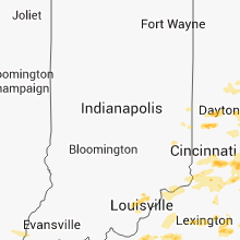
Indiana
| Local Time | Report Details |
|---|---|
| 7:00 PM EDT | Large branch taken off of tree in clark county IN, 37.4 miles N of Louisville, KY |
| 7:09 PM EDT | A trained spotter estimated 60 mph winds and half inch hai in clark county IN, 37.5 miles N of Louisville, KY |
| 7:10 PM CDT | Storm damage reported in lmz046 county IN, 38.6 miles ESE of Chicago, IL |
Connecticut
| Local Time | Report Details |
|---|---|
| 7:10 PM EDT | Tree down on home on west ln in fairfield county CT, 47.1 miles NNE of Brooklyn, NY |
| 7:15 PM EDT | Widespread trees down in litchfield county CT, 68.9 miles NNE of Brooklyn, NY |
| 7:20 PM EDT | Tree down on round hill road in fairfield county CT, 30 miles NE of Brooklyn, NY |
| 7:30 PM EDT | Tree fell due to wind in fairfield county CT, 61.9 miles NE of Brooklyn, NY |
| 7:30 PM EDT | Tree limbs blocking old stratfield rd in fairfield county CT, 52.1 miles NE of Brooklyn, NY |
| 7:40 PM EDT | Trees and wires down closing tremont s in new haven county CT, 65.7 miles NE of Brooklyn, NY |
| 7:45 PM EDT | Tree down on wires and blocking granville ave in new haven county CT, 61.2 miles NE of Brooklyn, NY |
| 8:24 PM EDT | Tree down at east rock rd and farnam dr in new haven county CT, 71.6 miles NE of Brooklyn, NY |
Maryland
| Local Time | Report Details |
|---|---|
| 8:00 PM EDT | 1 tree down in allegany county MD, 83.1 miles SSW of State College, PA |
| 9:08 PM EDT | Tree down on rt 30 south of carroll county lin in baltimore county MD, 21.7 miles NW of Baltimore, MD |
| 9:40 PM EDT | Tree down at railroad ave and york r in baltimore county MD, 13.2 miles N of Baltimore, MD |
| 9:59 PM EDT | Tree down on reckord road between harford road and bel air road in harford county MD, 16.9 miles NE of Baltimore, MD |
| 10:01 PM EDT | Tree down at us route 1 and harford road in harford county MD, 19.5 miles NE of Baltimore, MD |
Nebraska
| Local Time | Report Details |
|---|---|
| 7:54 PM CDT | Corn flattened in the are in seward county NE, 59.1 miles WSW of Omaha, NE |
| 7:54 PM CDT | Quarter sized hail reported near Seward, NE, 59.1 miles WSW of Omaha, NE |
| 8:06 PM CDT | Quarter sized hail reported near Malcolm, NE, 54.2 miles WSW of Omaha, NE |
Virginia
| Local Time | Report Details |
|---|---|
| 9:38 PM EDT | Tree down on leeds manor r in fauquier county VA, 75.2 miles WSW of Baltimore, MD |
Utah
| Local Time | Report Details |
|---|---|
| 7:45 PM MDT | Salt flats - 4265 ft in tooele county UT, 76.8 miles WSW of Salt Lake City, UT |
| 9:55 PM MDT | Callao gate - 4250 ft in tooele county UT, 85.2 miles SW of Salt Lake City, UT |
| 9:55 PM MDT | Horizontal grid - 4261 ft in tooele county UT, 77.8 miles WSW of Salt Lake City, UT |
| 10:45 PM MDT | Playa station - 4280 ft in tooele county UT, 72.8 miles WSW of Salt Lake City, UT |
Connect with Interactive Hail Maps