

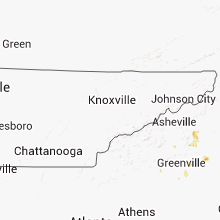
Hail Map for Thursday, July 25, 2013

Number of Impacted Households on 7/25/2013
0
Impacted by 1" or Larger Hail
0
Impacted by 1.75" or Larger Hail
0
Impacted by 2.5" or Larger Hail
Square Miles of Populated Area Impacted on 7/25/2013
0
Impacted by 1" or Larger Hail
0
Impacted by 1.75" or Larger Hail
0
Impacted by 2.5" or Larger Hail


Cities Most Affected by Hail Storms of 7/25/2013
| Hail Size | Demographics of Zip Codes Affected | ||||||
|---|---|---|---|---|---|---|---|
| City | Count | Average | Largest | Pop Density | House Value | Income | Age |
| Onalaska, WI | 2 | 2.25 | 2.50 | 764 | $114k | $49.0k | 39.3 |
| Brewster, KS | 1 | 2.50 | 2.50 | 1 | $42k | $36.6k | 43.3 |
| La Crosse, WI | 1 | 2.50 | 2.50 | 1607 | $78k | $31.8k | 37.3 |
| Harlowton, MT | 1 | 1.75 | 1.75 | 0 | $54k | $25.4k | 44.8 |
| Brewster, MN | 1 | 1.75 | 1.75 | 7 | $51k | $37.6k | 41.8 |
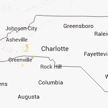
| Rutherfordton, NC | 1 | 1.75 | 1.75 | 109 | $88k | $35.9k | 44.1 |
| Kendall, KS | 1 | 1.75 | 1.75 | 0 | $39k | $37.2k | 45.7 |
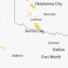
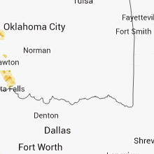
| Weatherford, OK | 1 | 1.75 | 1.75 | 64 | $84k | $28.5k | 26.4 |
| Geronimo, OK | 1 | 1.75 | 1.75 | 25 | $64k | $31.3k | 35.5 |
| Cowpens, SC | 1 | 1.75 | 1.75 | 204 | $78k | $33.1k | 38.3 |
Hail and Wind Damage Spotted on 7/25/2013
Filter by Report Type:Hail ReportsWind Reports
States Impacted
Texas, Nebraska, Arizona, Minnesota, North Carolina, Wisconsin, Kansas, California, Iowa, Georgia, South Carolina, Michigan, Montana, OklahomaTexas
| Local Time | Report Details |
|---|---|
| 7:40 AM MDT | Framing and boards from new construction completely blown down near sunland park dr and constitution. time approximat in el paso county TX, 5.8 miles NNW of El Paso, TX |
Nebraska
| Local Time | Report Details |
|---|---|
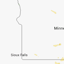
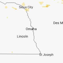
| 12:47 PM CDT | Quarter sized hail reported near Hartington, NE, 69.2 miles SSW of Sioux Falls, SD, hail up to quarter size but mostly 1/4 inch to 1/2 inch. |
| 12:47 PM CDT | Quarter sized hail reported near Hartington, NE, 71.4 miles SSW of Sioux Falls, SD, hail up to quarter size but mostly 1/4 inch to 1/2 inch. |
| 4:45 PM CDT | Storm damage reported in lincoln county NE, 4.4 miles E of North Platte, NE |
| 4:49 PM CDT | Storm damage reported in lincoln county NE, 4.4 miles E of North Platte, NE |
Arizona
| Local Time | Report Details |
|---|---|
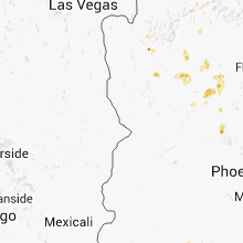
| 11:33 AM MST | Quarter sized hail reported near Flagstaff, AZ, 1.8 miles ESE of Flagstaff, AZ, accompanied by 1.25 inches of rain so far... |
Minnesota
| Local Time | Report Details |
|---|---|
| 1:53 PM CDT | Half Dollar sized hail reported near Fountain, MN, 39.1 miles W of La Crosse, WI, lasted about 10 min |
| 1:53 PM CDT | Half Dollar sized hail reported near Altura, MN, 36.6 miles WNW of La Crosse, WI, lasted about 10 min |
| 2:05 PM CDT | Quarter sized hail reported near Nett Lake, MN, 36.6 miles SSE of International Falls, MN, some accumulation |
| 2:05 PM CDT | Winds blew down 2 large oak trees and 7 cottonwood trees temporarily blocking road. there was a significant amount of 1/4 to 1/2 inch hail...sufficient to drift and rem in clearwater county MN, 28 miles NW of Bemidji, MN |
| 2:10 PM CDT | Quarter sized hail reported near Nett Lake, MN, 39.4 miles SSE of International Falls, MN |
| 2:54 PM CDT | Quarter sized hail reported near La Crescent, MN, 2.7 miles WNW of La Crosse, WI |
| 3:30 PM CDT | Larger swaths of corn blown down off 275th avenue between hwy 44 and cr 30. time estimated from rada in fillmore county MN, 46.9 miles WSW of La Crosse, WI |
| 3:31 PM CDT | Quarter sized hail reported near Harmony, MN, 44.7 miles WSW of La Crosse, WI, some crop damage in swath south of highway 52. |
| 4:00 PM CDT | Trees down near tower and at mckinley park. time estimate in st. louis county MN, 71.2 miles N of Duluth, MN |
| 4:20 PM CDT | Shingles blown off residents roof. numerous medium trees blown down including pines and popplers. significant 1/4 to 1/2 inch hail covered the ground for a period of ti in wadena county MN, 53.6 miles S of Bemidji, MN |
| 4:58 PM CDT | Golf Ball sized hail reported near Brewster, MN, 64.6 miles E of Sioux Falls, SD |
| 5:01 PM CDT | 10-12 inch tree down in crosslake via crow wing county sherif in crow wing county MN, 66.3 miles SE of Bemidji, MN |
| 5:26 PM CDT | Small trees knocked down by winds. diameter of the trees size of a softbal in crow wing county MN, 83.3 miles SE of Bemidji, MN |
North Carolina
| Local Time | Report Details |
|---|---|
| 3:20 PM EDT | Quarter sized hail reported near Newland, NC, 46.7 miles SSE of Bristol, TN, up to quarter size hail fell from 320 to 330 pm with hail continuning until 350 pm. truck at vfd dented by hail. |
| 5:18 PM EDT | Five separate reports of trees down in mario in mcdowell county NC, 64 miles S of Bristol, TN |
| 6:05 PM EDT | Golf Ball sized hail reported near Rutherfordton, NC, 53.3 miles NE of Greenville, SC, golfball size hail in the shingle hollow community. |
| 6:15 PM EDT | Quarter sized hail reported near Rutherfordton, NC, 50.2 miles NE of Greenville, SC, quarter size hail in the green hill community. |
| 6:51 PM EDT | 1 tree down off rutledge drive in flat roc in henderson county NC, 32.4 miles NNE of Greenville, SC |
| 6:55 PM EDT | Tree blocking rutledge driv in henderson county NC, 32.8 miles NNE of Greenville, SC |
| 9:40 PM EDT | Tree down in patterson springs in cleveland county NC, 38.6 miles W of Charlotte, NC |
Wisconsin
| Local Time | Report Details |
|---|---|
| 2:56 PM CDT | Tennis Ball sized hail reported near La Crosse, WI, 4.7 miles N of La Crosse, WI, official observer for la crosse airport |
| 2:57 PM CDT | Ping Pong Ball sized hail reported near Onalaska, WI, 4.8 miles NNE of La Crosse, WI |
| 3:02 PM CDT | 11 inch tree trunk split...which fell onto parked miniva in la crosse county WI, 5.6 miles NNE of La Crosse, WI |
| 3:03 PM CDT | Ping Pong Ball sized hail reported near Onalaska, WI, 5.6 miles NNE of La Crosse, WI |
| 3:04 PM CDT | Tennis Ball sized hail reported near Onalaska, WI, 5.6 miles NNE of La Crosse, WI |
| 3:05 PM CDT | Hen Egg sized hail reported near Onalaska, WI, 5 miles NE of La Crosse, WI, near valley view mall |
| 3:05 PM CDT | Ping Pong Ball sized hail reported near Onalaska, WI, 5 miles NE of La Crosse, WI, near valley view mall |
| 6:52 PM CDT | Power outages and numerous trees down in montreal. time estimated based on rada in iron county WI, 67.7 miles NW of Rhinelander, WI |
| 6:59 PM CDT | Quarter sized hail reported near Montreal, WI, 67.4 miles NW of Rhinelander, WI, pea to quarter sized hail. 6 inch diameter tree down from thunderstorm winds. |
Kansas
| Local Time | Report Details |
|---|---|
| 3:38 PM CDT | Storm damage reported in dickinson county KS, 39.2 miles WSW of Manhattan, KS |
| 3:39 PM CDT | Storm damage reported in dickinson county KS, 42 miles WSW of Manhattan, KS |
| 4:08 PM CDT | Tennis Ball sized hail reported near Brewster, KS, 17.8 miles WNW of Colby, KS, mostly quarter size hail with at least one stone that was 2 1/2 inches long and 1 inch wide. |
| 3:17 PM MDT | Numerous power poles were downed. roofs were blown off 2 hay building in hamilton county KS, 48.7 miles W of Garden City, KS |
| 3:28 PM MDT | Golf Ball sized hail reported near Kendall, KS, 39.9 miles W of Garden City, KS |
| 7:55 PM CDT | Storm damage reported in finney county KS, 5.6 miles N of Garden City, KS |
California
| Local Time | Report Details |
|---|---|
| 2:39 PM PDT | Quarter sized hail reported near , , 34.9 miles SSW of Reno, NV, trained spotter in homewood observed hail up to the size of quarters. |
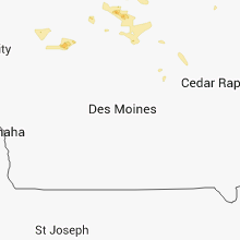
Iowa
| Local Time | Report Details |
|---|---|
| 4:54 PM CDT | Half Dollar sized hail reported near Garner, IA, 24.8 miles W of Mason City, IA, hail fell for 15 minutes in hayfield. time estimated from radar. |
| 5:23 PM CDT | Quarter sized hail reported near Garner, IA, 21.2 miles W of Mason City, IA |
| 5:43 PM CDT | Quarter sized hail reported near Pocahontas, IA, 19.1 miles E of Storm Lake, IA |
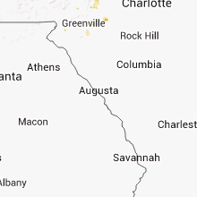
Georgia
| Local Time | Report Details |
|---|---|
| 6:07 PM EDT | Two trees down on laurel lodge road near highway 197 and another tree down about 3 miles farther down highway 197 toward batesvill in rabun county GA, 55.7 miles W of Greenville, SC |
| 6:10 PM EDT | 1 tree down off 15838 north state hwy 19 in habersham county GA, 56.3 miles W of Greenville, SC |
South Carolina
| Local Time | Report Details |
|---|---|
| 6:52 PM EDT | Trees down off porter rd and cove creek rd north of picken in pickens county SC, 11.4 miles NNW of Greenville, SC |
| 6:58 PM EDT | Multiple trees down off hwy 178 just north of picken in pickens county SC, 7.8 miles NW of Greenville, SC |
| 7:20 PM EDT | Quarter sized hail reported near Lyman, SC, 25.2 miles ENE of Greenville, SC, 1 inch hail reported ne of greer. |
| 7:34 PM EDT | Tree blocking sloan rd near lyma in spartanburg county SC, 26.2 miles ENE of Greenville, SC |
| 7:38 PM EDT | Multiple trees and power lines down along cape charles driv in greenville county SC, 16.1 miles E of Greenville, SC |
| 7:38 PM EDT | Quarter sized hail reported near Greenville, SC, 17.1 miles E of Greenville, SC, up to 1 inch hail reported at 230 roper mountain road extension. |
| 8:00 PM EDT | Mulitple large oak trees down on hwy 178 near hagood mills in pickens county SC, 10.5 miles NW of Greenville, SC |
| 8:40 PM EDT | Tree down at garrison rd and frontage rd in greenville county SC, 9.4 miles ESE of Greenville, SC |
| 8:40 PM EDT | Golf Ball sized hail reported near Cowpens, SC, 47.8 miles ENE of Greenville, SC, up to golf ball sized off iron ridge rd. |
| 9:00 PM EDT | Tree down at augusta rd and garrison rd in greenville county SC, 16.8 miles SE of Greenville, SC |
Michigan
| Local Time | Report Details |
|---|---|
| 6:15 PM CDT | Several trees reported down around the felch are in dickinson county MI, 42.6 miles SSW of Marquette, MI |
| 7:05 PM CDT | Several trees down or snappe in gogebic county MI, 64.6 miles NNW of Rhinelander, WI |
Montana
| Local Time | Report Details |
|---|---|
| 5:18 PM MDT | Half Dollar sized hail reported near Harlowton, MT, 77.7 miles NW of Billings, MT |
| 5:23 PM MDT | Golf Ball sized hail reported near Harlowton, MT, 78.1 miles NW of Billings, MT |
| 6:53 PM MDT | Half Dollar sized hail reported near Big Timber, MT, 49.1 miles WNW of Billings, MT |
| 6:53 PM MDT | Storm damage reported in sweet grass county MT, 49.1 miles WNW of Billings, MT |
Oklahoma
| Local Time | Report Details |
|---|---|
| 11:30 PM CDT | Several large tree branches down in the neighborhoo in custer county OK, 67.2 miles W of Oklahoma City, OK |
| 11:30 PM CDT | Golf Ball sized hail reported near Weatherford, OK, 67.2 miles W of Oklahoma City, OK, ping pong to golf ball size hail lasted for 5 minutes. |
| 3:21 AM CDT | Storm damage reported in comanche county OK, 47.9 miles N of Wichita Falls, TX |
| 3:45 AM CDT | Golf Ball sized hail reported near Geronimo, OK, 40 miles N of Wichita Falls, TX |
Connect with Interactive Hail Maps