

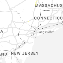
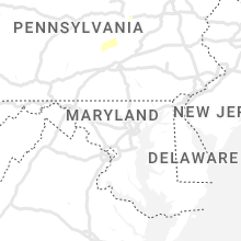
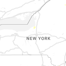
Hail Map for Sunday, July 9, 2023

Number of Impacted Households on 7/9/2023
0
Impacted by 1" or Larger Hail
0
Impacted by 1.75" or Larger Hail
0
Impacted by 2.5" or Larger Hail
Square Miles of Populated Area Impacted on 7/9/2023
0
Impacted by 1" or Larger Hail
0
Impacted by 1.75" or Larger Hail
0
Impacted by 2.5" or Larger Hail


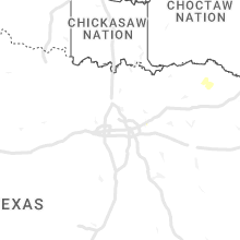


Cities Most Affected by Hail Storms of 7/9/2023
| Hail Size | Demographics of Zip Codes Affected | ||||||
|---|---|---|---|---|---|---|---|
| City | Count | Average | Largest | Pop Density | House Value | Income | Age |
| Rochert, MN | 1 | 2.00 | 2.00 | 15 | $110k | $39.4k | 49.9 |
| Motley, MN | 1 | 1.75 | 1.75 | 16 | $77k | $31.9k | 44.7 |
| Pillager, MN | 1 | 1.75 | 1.75 | 41 | $94k | $40.6k | 40.9 |
Hail and Wind Damage Spotted on 7/9/2023
Filter by Report Type:Hail ReportsWind Reports
States Impacted
Pennsylvania, North Carolina, Kentucky, Virginia, Florida, New York, West Virginia, Maryland, Vermont, Mississippi, Georgia, New Jersey, Delaware, South Carolina, MinnesotaPennsylvania
| Local Time | Report Details |
|---|---|
| 9:35 AM EDT | Trees and wires down along 990 sullivan rd near benton pa. report came in via monitoring of the columbia county 911 live fee in columbia county PA, 39.9 miles WSW of Scranton, PA |
| 10:15 AM EDT | Trees down on route 322 at mile marker 215. in perry county PA, 41.2 miles ESE of State College, PA |
| 10:45 AM EDT | Numerous large trees down on barners church roa in perry county PA, 47.6 miles ESE of State College, PA |
| 10:48 AM EDT | Trees down across route 147 near the vf in dauphin county PA, 49.5 miles ESE of State College, PA |
| 11:00 AM EDT | Tree across the roa in juniata county PA, 35.2 miles ESE of State College, PA |
| 11:08 AM EDT | Minor flooding along and on the roadway in juniata county PA, 39.4 miles ESE of State College, PA |
| 11:27 AM EDT | From pema: in the area of 5124 sugar run road. in tuscarora township tree down on roadway along with a tree down on norfolk southern (nsx) railroad tracks in that area in perry county PA, 41.2 miles ESE of State College, PA |
| 12:01 PM EDT | From pema: a garage roof blew off and struck a 1000-gallon propane tank on plum creek road in northumberland count in northumberland county PA, 58.9 miles E of State College, PA |
| 12:02 PM EDT | Tree dow in franklin county PA, 60.7 miles WNW of Baltimore, MD |
| 1:26 PM EDT | Road... city park and residential area floodin in juniata county PA, 38 miles ESE of State College, PA |
| 1:35 PM EDT | Trained spotter sent in pictures of trees down on iroquois ave near cornwall terrace elementary school that are blocking road. time estimated via rada in berks county PA, 77.4 miles SSW of Scranton, PA |
| 2:10 PM EDT | From pema: amtrak northeast pennsylvanian train 42 is stopped east of lewistown due to large debris blocking the tracks. per amtrak operations - pa train 42 is expectin in mifflin county PA, 23.2 miles SE of State College, PA |
| 3:28 PM EDT | Trees down on wire in lancaster county PA, 68 miles NNE of Baltimore, MD |
North Carolina
| Local Time | Report Details |
|---|---|
| 10:03 AM EDT | Tree downed by thunderstorm winds near the intersection of indian heaps road and highway 6 in yadkin county NC, 70.8 miles NNE of Charlotte, NC |
| 10:14 AM EDT | Tree downed by thunderstorm winds near the intersection of hauser road and highway 6 in yadkin county NC, 72.1 miles NNE of Charlotte, NC |
| 10:17 AM EDT | Powerlines were downed by thunderstorm winds near the intersection of butner mill road and nc highway 6 in yadkin county NC, 71.1 miles NNE of Charlotte, NC |
| 10:20 AM EDT | Tree reported down on 8900 block of reynolda roa in forsyth county NC, 71.6 miles NNE of Charlotte, NC |
| 10:50 AM EDT | Several hundred power outages due to fallen trees on equipmen in forsyth county NC, 73.6 miles S of Roanoke, VA |
| 10:56 AM EDT | A tree was downed by thunderstorm winds along phillips roa in stokes county NC, 58.3 miles S of Roanoke, VA |
| 10:58 AM EDT | Power poles broken. time estimated from rada in stokes county NC, 65.4 miles S of Roanoke, VA |
| 11:06 AM EDT | A few trees down and powerlines/powerpoles down at residence in belews cree in forsyth county NC, 71.5 miles S of Roanoke, VA |
| 11:19 AM EDT | Tree down on mt olive church rd union grove r in davidson county NC, 60.9 miles NNE of Charlotte, NC |
| 11:20 AM EDT | Tree down at residence on leonard-berrier r in davidson county NC, 61.2 miles NNE of Charlotte, NC |
| 11:23 AM EDT | Several hundred power outages due to fallen trees on equipmen in guilford county NC, 74.7 miles S of Roanoke, VA |
| 11:30 AM EDT | Tree downed by thunderstorm winds on lick fork creek roa in rockingham county NC, 62.8 miles SSE of Roanoke, VA |
| 11:36 AM EDT | Multiple large trees blocking road at intersection of onslow dr. and northampton d in guilford county NC, 69.8 miles WNW of Raleigh, NC |
| 11:39 AM EDT | Several hundred power outages due to down trees on equipmen in guilford county NC, 69.8 miles WNW of Raleigh, NC |
| 11:45 AM EDT | Tree down on e holly grove rd and embler r in davidson county NC, 56.2 miles NE of Charlotte, NC |
| 11:50 AM EDT | Tree down at fairgrove r in davidson county NC, 60.8 miles NE of Charlotte, NC |
| 11:52 AM EDT | Tree down at fuller mill r in davidson county NC, 61.1 miles NE of Charlotte, NC |
| 12:04 PM EDT | Trees down on power lines resulting in power outages near us highway 70 and springwood church r in guilford county NC, 54.3 miles WNW of Raleigh, NC |
| 12:15 PM EDT | Tree downed by thunderstorm winds in the 3200 block of country home roa in caswell county NC, 58.9 miles NW of Raleigh, NC |
| 12:21 PM EDT | Tree downed by thunderstorm winds near the intersection of highway 62 and zimmerman roa in caswell county NC, 57.5 miles NW of Raleigh, NC |
| 12:23 PM EDT | Tree reported down on edgewood drive and eden street in burlingto in alamance county NC, 49.9 miles WNW of Raleigh, NC |
| 12:24 PM EDT | Tree downed by thunderstorm winds near the intersection of longs mill road and daniel dairy roa in caswell county NC, 57.6 miles NW of Raleigh, NC |
| 12:27 PM EDT | Tree downed by thunderstorm winds on nc highway 6 in caswell county NC, 53.6 miles NW of Raleigh, NC |
| 12:37 PM EDT | Report from mping: 1-inch tree limbs broken; shingles blown of in stokes county NC, 73.5 miles SSW of Roanoke, VA |
| 12:43 PM EDT | Treed down on triple circle drive north of efla in orange county NC, 39.7 miles NW of Raleigh, NC |
| 12:48 PM EDT | Two trees down on cedar grove and efland roa in orange county NC, 35.9 miles NW of Raleigh, NC |
| 12:48 PM EDT | Tree reported down on intersection of millcreek road and lonesome roa in orange county NC, 40.5 miles NW of Raleigh, NC |
| 12:48 PM EDT | Multiple trees down along the lake. some snapped... some uproote in person county NC, 53.7 miles NNW of Raleigh, NC |
| 12:53 PM EDT | Multiple trees down on property off of eno cemetery roa in orange county NC, 38.4 miles NW of Raleigh, NC |
| 12:58 PM EDT | Trees down on power lines resulting in power outages around old nc-86 and old spring r in orange county NC, 29.1 miles WNW of Raleigh, NC |
| 1:07 PM EDT | Trees down on power lines near nc highway 87 and w salisbury st... resulting in hundreds of power outage in chatham county NC, 31.1 miles W of Raleigh, NC |
| 1:20 PM EDT | Hundreds of power outages due to trees down on equipmen in chatham county NC, 21.1 miles WNW of Raleigh, NC |
| 1:41 PM EDT | Power outages due to fallen trees on equipmen in wake county NC, 6.2 miles NW of Raleigh, NC |
| 1:45 PM EDT | Trees and power lines down resulting in power outages around mcdougald rd and adcock r in harnett county NC, 32.3 miles SSW of Raleigh, NC |
| 1:47 PM EDT | Power outages due to trees falling on equipmen in harnett county NC, 25 miles SSW of Raleigh, NC |
| 1:52 PM EDT | Power outages due to fallen trees on power equipmen in wake county NC, 2.4 miles E of Raleigh, NC |
| 1:58 PM EDT | Power outages due to fallen trees on equipmen in wake county NC, 14.2 miles S of Raleigh, NC |
| 2:09 PM EDT | Large tree down on power lines at mills street and wake forest road in raleig in wake county NC, 1.8 miles NNE of Raleigh, NC |
| 2:10 PM EDT | Tree down on power line at parish and augusta avenue near benson... n in johnston county NC, 27.7 miles S of Raleigh, NC |
| 2:15 PM EDT | Tree reported down across tilghman road between red hill church rd and apple jack lan in harnett county NC, 27.3 miles S of Raleigh, NC |
| 2:19 PM EDT | Trees and power lines down resulting in power outages around hannah creek rd and us-30 in johnston county NC, 27.1 miles SSE of Raleigh, NC |
| 2:48 PM EDT | Several trees down around wilso in wilson county NC, 47.4 miles E of Raleigh, NC |
| 2:48 PM EDT | Tree dow in johnston county NC, 29.9 miles S of Raleigh, NC |
| 2:48 PM EDT | Trees down along hayes mill r in sampson county NC, 45.9 miles S of Raleigh, NC |
| 2:49 PM EDT | Trees dow in johnston county NC, 34.5 miles SSE of Raleigh, NC |
| 2:50 PM EDT | Numerous trees down around the are in wayne county NC, 49.2 miles SE of Raleigh, NC |
| 2:59 PM EDT | Jones-onslow electric membership cooperative reports numerous power outages due to wires down in the richlands are in onslow county NC, 52.2 miles NNE of Wilmington, NC |
| 2:59 PM EDT | Trees down near linwood ave in goldsbor in wayne county NC, 46.6 miles SE of Raleigh, NC |
| 3:00 PM EDT | Trees and power lines down resulting in power outages around s pineview ave and e pine st in goldsbor in wayne county NC, 46.6 miles SE of Raleigh, NC |
| 3:04 PM EDT | Trees and power lines down causing power outages around wayne memorial dr and w new hope r in wayne county NC, 47.3 miles ESE of Raleigh, NC |
| 3:05 PM EDT | Trees and power lines down resulting in power outages around ebenezer forest rd and e elizabeth s in sampson county NC, 53.8 miles NNW of Wilmington, NC |
| 3:05 PM EDT | Tree dow in johnston county NC, 26 miles SE of Raleigh, NC |
| 3:10 PM EDT | Tree down near e new hope rd and may r in wayne county NC, 52.5 miles SE of Raleigh, NC |
| 3:43 PM EDT | Multiple power outages in northern duplin count in duplin county NC, 60.3 miles N of Wilmington, NC |
| 3:43 PM EDT | Powerline down. time estimated based on rada in craven county NC, 81.9 miles ESE of Raleigh, NC |
| 3:43 PM EDT | Tree down near bear hole road. time estimated based on rada in craven county NC, 83.4 miles NNE of Wilmington, NC |
| 3:44 PM EDT | Multiple power outages reported by power company. time estimated based on rada in craven county NC, 73.4 miles NNE of Wilmington, NC |
| 3:54 PM EDT | Tree down blocking the roa in duplin county NC, 41 miles N of Wilmington, NC |
| 3:56 PM EDT | Corrects previous tstm wnd dmg report from blanch. numerous trees of all sizes down between blanch and milton in the northeastern part of caswell county. several roads in caswell county NC, 61.9 miles NW of Raleigh, NC |
| 4:00 PM EDT | Power lines dow in pitt county NC, 72.3 miles ESE of Raleigh, NC |
| 4:34 PM EDT | Shingles blown off roof. trees snapped. spotter noted very strong winds as the storms moved throug in onslow county NC, 40.9 miles NNE of Wilmington, NC |
| 5:00 PM EDT | Public reported tree dow in onslow county NC, 53.4 miles NE of Wilmington, NC |
| 5:15 PM EDT | Carteret craven electical cooperative reports numerous power outages due to downed wire in carteret county NC, 59.8 miles ENE of Wilmington, NC |
| 5:28 PM EDT | Carteret craven electrical cooperative reports numerous power outages due to downed wire in carteret county NC, 69.3 miles ENE of Wilmington, NC |
Kentucky
| Local Time | Report Details |
|---|---|
| 12:01 PM EDT | Tree down across riverside drive at 4th av in greenup county KY, 61.3 miles WNW of Charleston, WV |
Virginia
| Local Time | Report Details |
|---|---|
| 12:24 PM EDT | Large limb downed by thunderstorm winds on hamilton blv in halifax county VA, 66 miles NNW of Raleigh, NC |
| 12:34 PM EDT | Large tree limb broken off tre in halifax county VA, 67.4 miles N of Raleigh, NC |
| 12:41 PM EDT | Tree downed by thunderstorm winds near intersection of bouldin road and ziglar roa in henry county VA, 45.6 miles S of Roanoke, VA |
| 12:53 PM EDT | Tree down across denniston roa in halifax county VA, 57.3 miles NNW of Raleigh, NC |
| 1:42 PM EDT | Trees down along nelson church rd near white house r in mecklenburg county VA, 57 miles N of Raleigh, NC |
| 1:57 PM EDT | Numerous trees down in and around the clarksville are in mecklenburg county VA, 58.4 miles N of Raleigh, NC |
| 2:40 PM EDT | Downed tree partially blocking us-58 in boydto in mecklenburg county VA, 62.6 miles NNE of Raleigh, NC |
| 2:45 PM EDT | Trees downed just off us-58 in south hil in mecklenburg county VA, 59.9 miles SSW of Richmond, VA |
| 4:24 PM EDT | Mesonet station wdsv2 willoughby deguassing statio in anz638 county VA, 21.2 miles NW of Virginia Beach, VA |
Florida
| Local Time | Report Details |
|---|---|
| 12:30 PM EDT | Awos station kvqq cecil fiel in duval county FL, 15.4 miles WSW of Jacksonville, FL |
| 12:40 PM EDT | Snapped tree caused damage to a roof in duclay near blanding blvd. time estimated by rada in duval county FL, 10.1 miles SW of Jacksonville, FL |
| 12:42 PM EDT | Awos station knip jacksonville naval air statio in duval county FL, 7.7 miles S of Jacksonville, FL |
| 12:45 PM EDT | Tree down in backyard off of w 2nd st. time estimated by rada in duval county FL, 0.6 miles NNW of Jacksonville, FL |
| 12:50 PM EDT | Spotter reports damage to a railroad crossing on talleyrand av in duval county FL, 2.5 miles NE of Jacksonville, FL |
| 12:50 PM EDT | Mesonet station 1323w 1.3 se jacksonville (weatherstem in duval county FL, 1.2 miles SE of Jacksonville, FL |
| 12:55 PM EDT | Tree down blocking right lane on i-295s near town center exit. time estimated by rada in duval county FL, 9.2 miles ESE of Jacksonville, FL |
| 1:00 PM EDT | Tree down on race track rd. time estimated by rada in st. johns county FL, 18.8 miles SSE of Jacksonville, FL |
| 1:01 PM EDT | Asos station kcrg jacksonvil crai in duval county FL, 8.1 miles E of Jacksonville, FL |
| 1:07 PM EDT | Estimated 60 mph wind gusts along hastings blvd with handheld speed devic in st. johns county FL, 43.7 miles SSE of Jacksonville, FL |
| 3:05 PM EDT | A large tree was blown down along blairstone road between park ave and mahan d in leon county FL, 2 miles ENE of Tallahassee, FL |
New York
| Local Time | Report Details |
|---|---|
| 1:05 PM EDT | Tree down on house with wire in orange county NY, 56.9 miles NNW of Brooklyn, NY |
| 2:53 PM EDT | Tree down blockig road on rt 67 and eagle bridge road in hoosick... ny in rensselaer county NY, 29.1 miles ENE of Schenectady, NY |
| 3:05 PM EDT | Tree down on hous in rensselaer county NY, 29.1 miles ENE of Schenectady, NY |
| 3:18 PM EDT | Meteorololgist reports multiple trees and wires down across albany... including on n lake ave and 3rd av in albany county NY, 13.6 miles SE of Schenectady, NY |
| 3:25 PM EDT | Public reports trees and wires down in guilderland. time esimated from rada in albany county NY, 8.2 miles SSE of Schenectady, NY |
| 3:35 PM EDT | A few small trees and tree limbs reported down near washington park and the intersection of madison ave and new scotland av in albany county NY, 14.2 miles SE of Schenectady, NY |
| 3:40 PM EDT | Many branches and a few trees reported down along rt 40 south of schaghticoke. time estimated from rada in rensselaer county NY, 17.9 miles ENE of Schenectady, NY |
| 3:50 PM EDT | Power lines and poles reported down near rt 67 and george thompson rd. time estimated from rada in saratoga county NY, 13.5 miles ENE of Schenectady, NY |
| 5:12 PM EDT | Reports of trees down between merrill and lyon mountain in clinton county NY, 41.6 miles WNW of Burlington, VT |
| 6:01 PM EDT | Trees and powerlines down along 374 northwest of lyon mountai in clinton county NY, 40.7 miles WNW of Burlington, VT |
West Virginia
| Local Time | Report Details |
|---|---|
| 1:08 PM EDT | Tree down on abbington court in hurrican in putnam county WV, 21.6 miles WNW of Charleston, WV |
| 4:52 PM EDT | A tree has fallen and brought down power lines down with i in raleigh county WV, 48.1 miles SSE of Charleston, WV |
| 6:23 PM EDT | Tree down at 4447 clover dr in campbells creek are in kanawha county WV, 6.8 miles ESE of Charleston, WV |
Maryland
| Local Time | Report Details |
|---|---|
| 1:37 PM EDT | Tree down on benevola church roa in washington county MD, 59 miles WNW of Baltimore, MD |
| 2:20 PM EDT | Multiple trees down near the 3800 block of urbana pik in frederick county MD, 39.8 miles W of Baltimore, MD |
| 3:16 PM EDT | One power-line down due to thunderstorm winds along the 3000 block houcks roa in harford county MD, 20.9 miles N of Baltimore, MD |
| 3:17 PM EDT | Tree down on the 2100 block of putnam road in harford county MD, 20.1 miles NNE of Baltimore, MD |
| 3:25 PM EDT | Tree down on the 1500 block of dooley road in harford county MD, 32.1 miles NNE of Baltimore, MD |
| 3:25 PM EDT | One large tree down due to thunderstorm widns at the intersection of fawn grove road and mcdermott roa in harford county MD, 30.2 miles NNE of Baltimore, MD |
| 3:30 PM EDT | Tree down on powerlines on the 3800 block of prospect road in harford county MD, 33.9 miles NNE of Baltimore, MD |
Vermont
| Local Time | Report Details |
|---|---|
| 2:04 PM EDT | Trees and branches down on jericho road in richmond in chittenden county VT, 11.8 miles ESE of Burlington, VT |
| 4:09 PM EDT | Many trees down in ainsworth state park with secondary roads blocked by trees in orange county VT, 42.8 miles SE of Burlington, VT |
| 4:35 PM EDT | Trees down on side of i89 in washington county VT, 30.3 miles ESE of Burlington, VT |
| 5:30 PM EDT | Town social media page reports trees down in roadways blocking some roads. time estimated from rada in rutland county VT, 52.5 miles S of Burlington, VT |
Mississippi
| Local Time | Report Details |
|---|---|
| 1:26 PM CDT | Mesonet (weatherflow) station xshi ship island. corrected event typ in gmz532 county MS, 63.6 miles WSW of Mobile, AL |
| 1:31 PM CDT | Mesonet (weeatherflow) station xshi ship islan in gmz532 county MS, 63.6 miles WSW of Mobile, AL |
| 3:30 PM CDT | A viewer sent in a picture of a large tree down across waverly ferry rd near the intersection of wilkins-wise r in lowndes county MS, 20.7 miles E of Starkville, MS |
Georgia
| Local Time | Report Details |
|---|---|
| 3:15 PM EDT | Three trees were blown down in the cairo are in grady county GA, 32.2 miles N of Tallahassee, FL |
| 3:55 PM EDT | A couple of trees were blown down along dirt roads across northern thomas count in thomas county GA, 49.3 miles NE of Tallahassee, FL |
| 4:00 PM EDT | Tree down near 1190 ione church roa in brooks county GA, 51.5 miles NE of Tallahassee, FL |
| 4:07 PM EDT | Tree down near 400 chitty roa in colquitt county GA, 53.8 miles WSW of Douglas, GA |
| 4:29 PM EDT | Tree down near highway 41 and brigman roa in lowndes county GA, 45.9 miles SW of Douglas, GA |
| 4:29 PM EDT | Trees down in cecil on highway 41 and a tree across the railroad tracks in cecil at fellowship roa in cook county GA, 44.8 miles SW of Douglas, GA |
| 4:31 PM EDT | Tree down near union road and brookridge d in lowndes county GA, 48.5 miles SW of Douglas, GA |
| 4:37 PM EDT | Tree down on a power line on overstreet roa in cook county GA, 38.7 miles SW of Douglas, GA |
New Jersey
| Local Time | Report Details |
|---|---|
| 3:32 PM EDT | Picture received of street flooding on cokesbury rd on border of lebanon borough and tewksbury townshi in hunterdon county NJ, 44.6 miles W of Brooklyn, NY |
Delaware
| Local Time | Report Details |
|---|---|
| 4:20 PM EDT | Report of large tree limbs down on pearsons corner road in dover. time estimated via rada in kent county DE, 52.5 miles E of Baltimore, MD |
| 4:48 PM EDT | Emergency manager coordinator relays report of a roof blown off a house on choppin drive in middletown. time estimated via rada in new castle county DE, 52.3 miles ENE of Baltimore, MD |
| 4:50 PM EDT | Emergency manager coordinator relays report of roof damage at bayberry south on rte 896. time estimated via rada in new castle county DE, 52.3 miles ENE of Baltimore, MD |
| 4:51 PM EDT | Delayed report of an over-turned tractor trailer on route 1 sb that occurred when storms passed earlie in new castle county DE, 54.2 miles ENE of Baltimore, MD |
| 4:51 PM EDT | Received several photos of large trees... tree limbs down and partial roofs ripped off of houses along hyetts corner road. tornado possible. time estimated via rada in new castle county DE, 53.2 miles ENE of Baltimore, MD |
| 6:00 PM EDT | Damage in neighborhood on the north side of middletown... de. large neighborhood entrance sign knocked down... trees down... and parts of roofs torn off. report via soc in new castle county DE, 48.9 miles ENE of Baltimore, MD |
South Carolina
| Local Time | Report Details |
|---|---|
| 6:50 PM EDT | Social media photo shows a large tree limb down partially blocking the road. time estimated by rada in richland county SC, 65.9 miles NE of Augusta, GA |
Minnesota
| Local Time | Report Details |
|---|---|
| 6:43 PM CDT | Half Dollar sized hail reported near Brainerd, MN, 76.6 miles SSE of Bemidji, MN, photos of spikey hail. longest axis along the spikes was 1.25 inches with a semi minor axis of about penny size. |
| 6:53 PM CDT | Quarter sized hail reported near Brainerd, MN, 78.1 miles SSE of Bemidji, MN |
| 7:27 PM CDT | Quarter sized hail reported near Motley, MN, 76.7 miles S of Bemidji, MN, average hail size was between nickels and quarters with the largest being quarter-sized. |
| 7:38 PM CDT | Golf Ball sized hail reported near Pillager, MN, 79.5 miles S of Bemidji, MN, hail lasted about 3 minutes. |
| 7:38 PM CDT | Half Dollar sized hail reported near Motley, MN, 80.1 miles S of Bemidji, MN, time estimated by radar. hail was found after the storm passed. damage to vehicles was observed. |
| 7:38 PM CDT | Golf Ball sized hail reported near Motley, MN, 81 miles S of Bemidji, MN |
| 7:40 PM CDT | Ping Pong Ball sized hail reported near Borup, MN, 29 miles NE of Fargo, ND, quarter to ping pong ball sized hail reported by public east of borup. relayed via broadcast media... time estimated from radar. |
| 7:53 PM CDT | Ping Pong Ball sized hail reported near Pillager, MN, 81.9 miles SSE of Bemidji, MN |
| 8:05 PM CDT | Quarter sized hail reported near Shevlin, MN, 18.2 miles WNW of Bemidji, MN, public reports quarter sized hail in shevlin. |
| 8:10 PM CDT | Half Dollar sized hail reported near Solway, MN, 13.3 miles W of Bemidji, MN, emergency manager relays report from public sw of solway of quarter to half dollar sized hail. |
| 8:16 PM CDT | Half Dollar sized hail reported near Bemidji, MN, 8.4 miles SW of Bemidji, MN, public reports hail 9sw bemidji ranging in size from peas to half dollar. |
| 8:20 PM CDT | Half Dollar sized hail reported near Solway, MN, 16.3 miles SW of Bemidji, MN, public reports hail in becida... around half dollar and quarter sized. |
| 8:37 PM CDT | Quarter sized hail reported near Bemidji, MN, 9.2 miles S of Bemidji, MN, quarter sized hail reported 10 s bemidji in hubbard county. |
| 8:45 PM CDT | Hen Egg sized hail reported near Rochert, MN, 50.3 miles E of Fargo, ND, broadcast media relays report of large hail in pickerel lake. |
| 8:46 PM CDT | Quarter sized hail reported near Detroit Lakes, MN, 44.7 miles E of Fargo, ND, report of quarter sized hail via email. |
| 8:50 PM CDT | Half Dollar sized hail reported near Rochert, MN, 53.9 miles SW of Bemidji, MN, relayed via facebook... image of half dollar sized hail. |
| 9:00 PM CDT | Half Dollar sized hail reported near Frazee, MN, 56.7 miles E of Fargo, ND, half dollar sized hail from our co-op observer 12 e detroit lakes. |
Connect with Interactive Hail Maps