

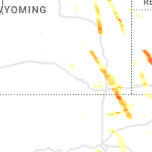
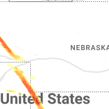
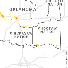
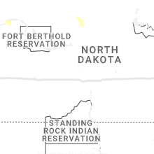
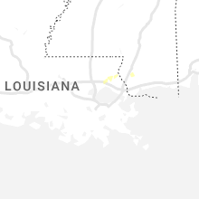
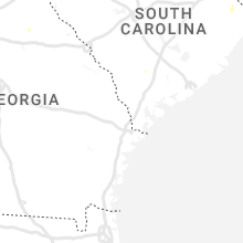
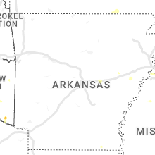
Hail Map for Saturday, July 8, 2023

Number of Impacted Households on 7/8/2023
0
Impacted by 1" or Larger Hail
0
Impacted by 1.75" or Larger Hail
0
Impacted by 2.5" or Larger Hail
Square Miles of Populated Area Impacted on 7/8/2023
0
Impacted by 1" or Larger Hail
0
Impacted by 1.75" or Larger Hail
0
Impacted by 2.5" or Larger Hail


Cities Most Affected by Hail Storms of 7/8/2023
| Hail Size | Demographics of Zip Codes Affected | ||||||
|---|---|---|---|---|---|---|---|
| City | Count | Average | Largest | Pop Density | House Value | Income | Age |
| Wray, CO | 6 | 2.13 | 2.75 | 5 | $72k | $33.4k | 39.1 |
| Oklahoma City, OK | 3 | 2.08 | 2.75 | 2002 | $65k | $31.4k | 32.1 |
| Colorado Springs, CO | 1 | 3.00 | 3.00 | 41 | $147k | $40.6k | 41.4 |
| Karval, CO | 1 | 2.50 | 2.50 | 0 | $40k | $29.5k | 46.4 |
| Bridgeport, NE | 1 | 2.00 | 2.00 | 2 | $50k | $30.3k | 42.9 |
| Rush, CO | 1 | 2.00 | 2.00 | 1 | $105k | $34.3k | 43.5 |
| Holyoke, CO | 1 | 1.75 | 1.75 | 6 | $81k | $32.1k | 41.5 |
| Newcastle, WY | 1 | 1.75 | 1.75 | 2 | $67k | $32.8k | 42.4 |
| Littleton, CO | 1 | 1.75 | 1.75 | 3750 | $197k | $63.5k | 40.2 |
| Haxtun, CO | 1 | 1.75 | 1.75 | 3 | $78k | $32.3k | 46.3 |
| Douglas, WY | 1 | 1.75 | 1.75 | 3 | $88k | $39.7k | 38.0 |
| Scottsbluff, NE | 1 | 1.75 | 1.75 | 157 | $75k | $31.0k | 37.9 |
| Minatare, NE | 1 | 1.75 | 1.75 | 9 | $46k | $31.0k | 41.7 |
Hail and Wind Damage Spotted on 7/8/2023
Filter by Report Type:Hail ReportsWind Reports
States Impacted
Indiana, Oklahoma, North Carolina, Mississippi, South Dakota, Nebraska, South Carolina, Colorado, Tennessee, Wyoming, Virginia, Georgia, Alabama, Kansas, Kentucky, Florida, TexasIndiana
| Local Time | Report Details |
|---|---|
| 9:52 AM EDT | Tree down on occupied car. no injurie in rush county IN, 38.7 miles ESE of Indianapolis, IN |
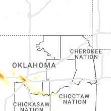
Oklahoma
| Local Time | Report Details |
|---|---|
| 9:38 AM CDT | Report from mping: 3-inch tree limbs broken; power poles broke in le flore county OK, 40.8 miles SSW of Fort Smith, AR |
| 9:40 AM CDT | Large tree and power pole snapped in hodgen via twitte in le flore county OK, 39.4 miles SSW of Fort Smith, AR |
| 11:23 PM CDT | Large tree downed across road. report submitted with photo. time estimated from rada in texas county OK, 82.8 miles SSW of Garden City, KS |
| 11:30 PM CDT | Storm damage reported in texas county OK, 79 miles SSW of Garden City, KS |
| 11:40 PM CDT | Storm damage reported in beaver county OK, 67.8 miles WNW of Woodward, OK |
| 11:46 PM CDT | Storm damage reported in texas county OK, 95.6 miles SSW of Garden City, KS |
| 1:40 AM CDT | Quarter sized hail reported near Norman, OK, 19.7 miles S of Oklahoma City, OK, report from mping: quarter (1.00 in.). |
| 1:40 AM CDT | Half Dollar sized hail reported near Norman, OK, 19.1 miles S of Oklahoma City, OK, report from mping: half dollar (1.25 in.). |
| 1:40 AM CDT | Storm damage reported in ellis county OK, 36.7 miles SW of Woodward, OK |
| 1:50 AM CDT | Mesonet wind gus in dewey county OK, 43.9 miles SSE of Woodward, OK |
| 1:55 AM CDT | Storm damage reported in dewey county OK, 43.9 miles SSE of Woodward, OK |
| 1:57 AM CDT | Quarter sized hail reported near Norman, OK, 18.9 miles SSE of Oklahoma City, OK |
| 2:05 AM CDT | Storm damage reported in dewey county OK, 43.9 miles SSE of Woodward, OK |
| 2:10 AM CDT | Storm damage reported in roger mills county OK, 64 miles SSW of Woodward, OK |
| 2:30 AM CDT | Major roof damage to church youth center near swosu... many roofs damage in weatherford... power lines down mainly in northeast side of town. via kwey. time estimate in custer county OK, 67.2 miles W of Oklahoma City, OK |
| 2:31 AM CDT | Quarter sized hail reported near Weatherford, OK, 66.8 miles W of Oklahoma City, OK, report from mping: quarter (1.00 in.). |
| 2:34 AM CDT | Ping Pong Ball sized hail reported near Weatherford, OK, 66.8 miles W of Oklahoma City, OK, report from mping: ping pong ball (1.50 in.). |
| 2:34 AM CDT | Ping Pong Ball sized hail reported near Hydro, OK, 66.9 miles W of Oklahoma City, OK |
| 2:48 AM CDT | Kcsm aso in custer county OK, 68.1 miles SSE of Woodward, OK |
| 2:53 AM CDT | Quarter sized hail reported near Yukon, OK, 12 miles W of Oklahoma City, OK, report from mping: quarter (1.00 in.). |
| 3:05 AM CDT | Quarter sized hail reported near Yukon, OK, 11.9 miles W of Oklahoma City, OK |
| 3:17 AM CDT | Storm damage reported in jackson county OK, 54.9 miles ENE of Childress, TX |
| 3:21 AM CDT | Golf Ball sized hail reported near Oklahoma City, OK, 5.1 miles W of Oklahoma City, OK |
| 3:28 AM CDT | Golf Ball sized hail reported near Oklahoma City, OK, 5.9 miles SSW of Oklahoma City, OK |
| 3:28 AM CDT | Half Dollar sized hail reported near Oklahoma City, OK, 7.2 miles SW of Oklahoma City, OK, will rogers world airport. |
| 3:30 AM CDT | Storm damage reported in jackson county OK, 52.3 miles ENE of Childress, TX |
| 3:30 AM CDT | Storm damage reported in caddo county OK, 57.5 miles WSW of Oklahoma City, OK |
| 3:34 AM CDT | Baseball sized hail reported near Oklahoma City, OK, 3.6 miles SW of Oklahoma City, OK |
| 3:45 AM CDT | Storm damage reported in tillman county OK, 52.3 miles NW of Wichita Falls, TX |
| 3:47 AM CDT | Will rogers world airpor in oklahoma county OK, 7.2 miles SW of Oklahoma City, OK |
| 3:52 AM CDT | Storm damage reported in cleveland county OK, 11.3 miles S of Oklahoma City, OK |
| 3:55 AM CDT | Chickasha municipal airpor in grady county OK, 36.6 miles SW of Oklahoma City, OK |
| 4:05 AM CDT | Storm damage reported in tillman county OK, 36.5 miles NW of Wichita Falls, TX |
| 4:20 AM CDT | Storm damage reported in mcclain county OK, 16 miles SSW of Oklahoma City, OK |
North Carolina
| Local Time | Report Details |
|---|---|
| 1:31 PM EDT | Trees down on power lines/utility equipmen in mecklenburg county NC, 1.8 miles ESE of Charlotte, NC |
| 7:59 PM EDT | Tree down along old 60 hw in wilkes county NC, 67.3 miles N of Charlotte, NC |
| 8:19 PM EDT | Tree down at 2500 block of wilkes yadkin roa in wilkes county NC, 65.1 miles N of Charlotte, NC |
| 8:26 PM EDT | Tree and power lines down along somers roa in wilkes county NC, 63.5 miles N of Charlotte, NC |
| 8:34 PM EDT | A few trees snapped in half in the area of mccarter rd/hunting creek r in wilkes county NC, 59.5 miles N of Charlotte, NC |
| 8:35 PM EDT | Multiple trees down area of hunting creek r in wilkes county NC, 58.8 miles N of Charlotte, NC |
| 8:50 PM EDT | Large tree blocking roadway near the intersection of jennings rd and eupeptic springs r in iredell county NC, 53.7 miles N of Charlotte, NC |
Mississippi
| Local Time | Report Details |
|---|---|
| 12:52 PM CDT | Large tree down on tulane rd. south of church r in desoto county MS, 15.2 miles S of Memphis, TN |
| 7:34 PM CDT | A tree fell through a fence on hospital d in hinds county MS, 4.1 miles W of Jackson, MS |
| 8:14 PM CDT | A tree was reported down across woodrow martin roa in rankin county MS, 25.4 miles ESE of Jackson, MS |
South Dakota
| Local Time | Report Details |
|---|---|
| 12:30 PM MDT | Quarter sized hail reported near Rapid City, SD, 13.1 miles WSW of Rapid City, SD, mping report |
Nebraska
| Local Time | Report Details |
|---|---|
| 1:06 PM MDT | Quarter sized hail reported near Scottsbluff, NE, 8.2 miles N of Scottsbluff, NE |
| 1:13 PM MDT | Received phone call for pea size hail... tree branches down... inch of rai in scotts bluff county NE, 7.3 miles NNE of Scottsbluff, NE |
| 1:37 PM MDT | Quarter sized hail reported near Minatare, NE, 12.1 miles ESE of Scottsbluff, NE, corrects time of minatare 3 east report based on radar imagery. twitter post for quarter sized hail 3 miles east of minatare. |
| 1:42 PM MDT | Quarter sized hail reported near Minatare, NE, 13.3 miles ENE of Scottsbluff, NE |
| 1:49 PM MDT | Quarter sized hail reported near Minatare, NE, 12.1 miles ESE of Scottsbluff, NE |
| 1:53 PM MDT | Golf Ball sized hail reported near Scottsbluff, NE, 2.7 miles SE of Scottsbluff, NE |
| 1:53 PM MDT | Golf Ball sized hail reported near Minatare, NE, 13 miles ESE of Scottsbluff, NE, corrects previous hail report from 3 ene gering. |
| 2:13 PM MDT | Ping Pong Ball sized hail reported near Bayard, NE, 21.6 miles ESE of Scottsbluff, NE |
| 2:35 PM MDT | Hen Egg sized hail reported near Bridgeport, NE, 34.7 miles SE of Scottsbluff, NE, received photos of hail and of cracked windshield via facebook. |
| 2:37 PM MDT | Quarter sized hail reported near Minatare, NE, 12.1 miles ESE of Scottsbluff, NE, corrected time based on radar imagery. picture from twitter of slightly larger than quarter sized hail 3 miles east of minatare. |
| 2:48 PM MDT | Quarter sized hail reported near Minatare, NE, 12.1 miles ESE of Scottsbluff, NE, picture from twitter of slightly larger than quarter sized hail 3 miles east of minatare. |
| 3:32 PM MDT | Quarter sized hail reported near Gurley, NE, 55.9 miles SE of Scottsbluff, NE, video from social media showing hailstones ranging from dime to quarter size. |
| 3:42 PM MDT | Quarter sized hail reported near Kimball, NE, 28 miles S of Scottsbluff, NE |
| 3:50 PM MDT | Upr site sunol1. gust 63 mph at 355p in cheyenne county NE, 67.5 miles SE of Scottsbluff, NE |
| 3:52 PM MDT | Emergency manager reported a flipped pivot and completely stripped vegetation (corn crops in cheyenne county NE, 65.3 miles SE of Scottsbluff, NE |
| 4:30 PM MDT | Quarter sized hail reported near Kimball, NE, 42.2 miles S of Scottsbluff, NE |
South Carolina
| Local Time | Report Details |
|---|---|
| 3:28 PM EDT | Orangeburg county 911 call center reported a tree down at the intersection of north rd. and slab landing rd. time estimated by rada in orangeburg county SC, 53.7 miles E of Augusta, GA |
| 7:26 PM EDT | Fairfield county dispatch reported power lines down on wateree estates rd. time estimated by rada in fairfield county SC, 55.4 miles S of Charlotte, NC |
| 7:35 PM EDT | Newberry county sheriffs office reported a tree in the roadway near 717 state park rd. which was quickly cleaned up. time estimated by rada in newberry county SC, 53.3 miles NE of Augusta, GA |
| 7:36 PM EDT | Newberry county sheriffs office reported a tree falling on a residence at this location causing significant damage. time estimated by rada in newberry county SC, 53.1 miles NE of Augusta, GA |
| 8:00 PM EDT | Trained spotter relayed multiple tree limbs down among other smaller tree debris on us-21 between ridgeway and blythewood. he later reported a downed tree limb causing in fairfield county SC, 64 miles S of Charlotte, NC |
Colorado
| Local Time | Report Details |
|---|---|
| 2:15 PM MDT | Quarter sized hail reported near Haxtun, CO, 39.1 miles N of Yuma, CO |
| 3:30 PM MDT | Baseball sized hail reported near Wray, CO, 28.2 miles ENE of Yuma, CO, hail up to baseballs in size reported to have accumulated at location via social media. hail reported to have broken windows on a vehicle... put dents in a trailer... a |
| 3:30 PM MDT | Photo received via social media of wind damage to a large tree bending it almost at a 45 degree angle at the locatio in yuma county CO, 28.2 miles ENE of Yuma, CO |
| 3:33 PM MDT | Quarter sized hail reported near Littleton, CO, 11.8 miles SW of Denver, CO, report from mping: quarter (1.00 in.) time estimated by radar. |
| 3:36 PM MDT | Quarter sized hail reported near Littleton, CO, 9.5 miles SW of Denver, CO, report from mping: quarter (1.00 in.). |
| 3:38 PM MDT | Half Dollar sized hail reported near Littleton, CO, 10.4 miles S of Denver, CO |
| 3:39 PM MDT | Quarter sized hail reported near Littleton, CO, 10.1 miles SSW of Denver, CO, report from mping: quarter (1.00 in.). |
| 3:39 PM MDT | Half Dollar sized hail reported near Littleton, CO, 11 miles SW of Denver, CO |
| 3:40 PM MDT | Baseball sized hail reported near Wray, CO, 27.4 miles ENE of Yuma, CO, corrects previous hail report from 1 sse wauneta. reported via social media. golf ball hail to baseball hail observed with damage to crops. hail was mostly golf ball si |
| 3:40 PM MDT | Golf Ball sized hail reported near Wray, CO, 27.4 miles ENE of Yuma, CO, reported via social media. golf ball hail is ongoing. |
| 3:41 PM MDT | Golf Ball sized hail reported near Littleton, CO, 10 miles SSW of Denver, CO |
| 3:42 PM MDT | Half Dollar sized hail reported near Littleton, CO, 11.4 miles SSW of Denver, CO |
| 3:43 PM MDT | Ping Pong Ball sized hail reported near Littleton, CO, 11.2 miles S of Denver, CO |
| 3:45 PM MDT | Quarter sized hail reported near Littleton, CO, 10.4 miles S of Denver, CO, report from mping: quarter (1.00 in.). |
| 3:45 PM MDT | Quarter sized hail reported near Littleton, CO, 12.6 miles S of Denver, CO, report from mping: quarter (1.00 in.). |
| 3:47 PM MDT | Ping Pong Ball sized hail reported near Littleton, CO, 10.1 miles SSW of Denver, CO, report from mping: ping pong ball (1.50 in.). time estimated by radar. |
| 3:51 PM MDT | Ping Pong Ball sized hail reported near Littleton, CO, 13.2 miles S of Denver, CO, report from mping: ping pong ball (1.50 in.). |
| 3:53 PM MDT | Quarter sized hail reported near Littleton, CO, 13.2 miles S of Denver, CO, report from mping: quarter (1.00 in.). |
| 3:53 PM MDT | Quarter sized hail reported near Littleton, CO, 15.4 miles S of Denver, CO, report from mping: quarter (1.00 in.). |
| 3:53 PM MDT | Golf Ball sized hail reported near Wray, CO, 32.6 miles E of Yuma, CO, hail up to golf balls in size reported via social media at location. hail broke vehicle side mirror and tail light as well as put several dents into the vehicle. |
| 3:53 PM MDT | Hen Egg sized hail reported near Wray, CO, 32.6 miles E of Yuma, CO, corrects previous hail report from laird. hail larger than golf balls in size reported via social media at location. hail broke a vehicle side mirror and a tail light a |
| 3:54 PM MDT | Ping Pong Ball sized hail reported near Littleton, CO, 10.4 miles S of Denver, CO, report from mping: ping pong ball (1.50 in.). |
| 3:55 PM MDT | Tree branches reported down due to thunderstorm wind gusts in wray... c in yuma county CO, 27.3 miles E of Yuma, CO |
| 3:55 PM MDT | Golf Ball sized hail reported near Wray, CO, 30.5 miles E of Yuma, CO, golf ball sized hail reported at location. |
| 4:04 PM MDT | Quarter sized hail reported near Colorado Springs, CO, 50.7 miles N of Pueblo, CO |
| 4:07 PM MDT | Golf Ball sized hail reported near Holyoke, CO, 28.3 miles ENE of Yuma, CO, hail around golf ball size or slightly larger reported at location via social media. |
| 4:08 PM MDT | Half Dollar sized hail reported near Parker, CO, 18.3 miles SSE of Denver, CO, report from mping: half dollar (1.25 in.). |
| 4:09 PM MDT | Quarter sized hail reported near Parker, CO, 18.9 miles SE of Denver, CO, report from mping: quarter (1.00 in.). |
| 4:13 PM MDT | Quarter sized hail reported near Colorado Springs, CO, 48.3 miles N of Pueblo, CO |
| 4:32 PM MDT | Quarter sized hail reported near Colorado Springs, CO, 39.9 miles N of Pueblo, CO |
| 4:32 PM MDT | Ping Pong Ball sized hail reported near Colorado Springs, CO, 40.4 miles N of Pueblo, CO |
| 4:33 PM MDT | Tea Cup sized hail reported near Colorado Springs, CO, 39.2 miles N of Pueblo, CO, photo from social media shows hailstones at least 3 inches in fiameter in the vicinity of schriever space force base. time based on radar. |
| 5:05 PM MDT | Storm damage reported in phillips county CO, 37.7 miles N of Yuma, CO |
| 5:07 PM MDT | Golf Ball sized hail reported near Haxtun, CO, 36.3 miles N of Yuma, CO |
| 5:17 PM MDT | Quarter sized hail reported near Colorado Springs, CO, 33.2 miles NNE of Pueblo, CO |
| 7:08 PM MDT | Quarter sized hail reported near Rocky Ford, CO, 50 miles ESE of Pueblo, CO |
| 7:15 PM MDT | Ping Pong Ball sized hail reported near Rocky Ford, CO, 55.5 miles ESE of Pueblo, CO |
| 7:21 PM MDT | Ping Pong Ball sized hail reported near La Junta, CO, 56.3 miles ESE of Pueblo, CO |
| 7:30 PM MDT | Mesonet station tt567 crow creek. time estimated per radar since only hourly peak wind gusts availabl in weld county CO, 71.6 miles NNE of Denver, CO |
| 7:50 PM MDT | Tennis Ball sized hail reported near Karval, CO, 57.2 miles ENE of Pueblo, CO, sporadic stones lying on ground. delayed report. |
| 7:54 PM MDT | Quarter sized hail reported near Briggsdale, CO, 75.2 miles NNE of Denver, CO |
| 7:56 PM MDT | Quarter sized hail reported near Briggsdale, CO, 73.5 miles NE of Denver, CO |
| 8:00 PM MDT | Hen Egg sized hail reported near Rush, CO, 58 miles ENE of Pueblo, CO |
| 8:06 PM MDT | Ping Pong Ball sized hail reported near Karval, CO, 58.1 miles ENE of Pueblo, CO, report from mping: ping pong ball (1.50 in.). |
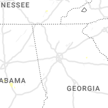
Tennessee
| Local Time | Report Details |
|---|---|
| 3:20 PM CDT | Wind gust estimated at 60 mph. also....penny size hai in robertson county TN, 23.2 miles N of Nashville, TN |
| 3:35 PM CDT | Estimated wind gusts of 60 mp in dickson county TN, 24.2 miles W of Nashville, TN |
| 3:50 PM CDT | Roof torn off an outbuilding and landed on a truc in robertson county TN, 18.1 miles N of Nashville, TN |
| 4:48 PM CDT | *** 2 inj *** trees down across roadways. one tree down on campbellsville pike and it fell on a truck. 2 people were inside it and they sustained minor injurie in maury county TN, 44.6 miles SSW of Nashville, TN |
| 5:15 PM CDT | Limbs blown down along cool springs blvd and mallory lan in williamson county TN, 15.4 miles SSW of Nashville, TN |
Wyoming
| Local Time | Report Details |
|---|---|
| 2:28 PM MDT | Ping Pong Ball sized hail reported near Lusk, WY, 75.1 miles NNW of Scottsbluff, NE, hail ranged from pea sized to ping pong ball sized. |
| 2:38 PM MDT | Quarter sized hail reported near Lusk, WY, 74 miles NNW of Scottsbluff, NE, quarter sized hail. visibility 50 yards in mostly hail. |
| 3:11 PM MDT | Quarter sized hail reported near Lusk, WY, 62.2 miles NW of Scottsbluff, NE |
| 4:40 PM MDT | Golf Ball sized hail reported near Newcastle, WY, 62.4 miles SSE of Gillette, WY, lasted 5-10 minutes. |
| 5:55 PM MDT | Golf Ball sized hail reported near Douglas, WY, 59.5 miles ENE of Casper, WY |
| 6:39 PM MDT | Quarter sized hail reported near Douglas, WY, 64.5 miles ENE of Casper, WY, social media report of quarter size hail that shredded trees/plants and broke a window. |
| 7:00 PM MDT | Half Dollar sized hail reported near Cheyenne, WY, 44.7 miles ENE of Laramie, WY |
| 7:00 PM MDT | Half Dollar sized hail reported near Cheyenne, WY, 33.9 miles ENE of Laramie, WY |
| 7:22 PM MDT | Half Dollar sized hail reported near Douglas, WY, 62.5 miles E of Casper, WY |
| 7:38 PM MDT | Mesonet station wy56 interstate 25 platte and converse county lin in platte county WY, 64.8 miles ESE of Casper, WY |
| 7:48 PM MDT | Quarter sized hail reported near Cheyenne, WY, 46.6 miles E of Laramie, WY |
Virginia
| Local Time | Report Details |
|---|---|
| 4:30 PM EDT | Large tree downed onto a power pole at intersection of beaverdam rd and holly bush roa in surry county VA, 49.6 miles ESE of Richmond, VA |
| 4:40 PM EDT | Numerous trees reported down across central and southern surry county. time estimate in surry county VA, 42 miles WNW of Virginia Beach, VA |
| 4:45 PM EDT | Tree downed along alliance roa in surry county VA, 48.4 miles WNW of Virginia Beach, VA |
| 6:53 PM EDT | Multiple trees down on w hoover roa in madison county VA, 73.5 miles NNW of Richmond, VA |
Georgia
| Local Time | Report Details |
|---|---|
| 4:40 PM EDT | The savannah entrance light reported a 53 knot wind gust with a thunderstor in amz352 county GA, 17.2 miles ESE of Savannah, GA |
Alabama
| Local Time | Report Details |
|---|---|
| 4:35 PM CDT | Tree down on county road 47 in coffee county AL, 60.1 miles NNE of Miramar Beach, FL |
| 4:42 PM CDT | A few trees were blown down north of ozar in dale county AL, 76.3 miles S of Auburn, AL |
| 4:50 PM CDT | Tree down near chancellor just west of alabama state rd 27 per 911 dispatc in geneva county AL, 61.5 miles NNE of Miramar Beach, FL |
| 5:08 PM CDT | A few trees were blown down south of ozar in dale county AL, 79.8 miles NE of Miramar Beach, FL |
| 5:25 PM CDT | Trees down in the southern junction are in houston county AL, 69.6 miles NE of Miramar Beach, FL |
| 5:27 PM CDT | Trees down in the rehobeth are in houston county AL, 75.5 miles NE of Miramar Beach, FL |
| 5:29 PM CDT | Trees were blown down along alabama highway 109 at providence road near the florida lin in houston county AL, 71.4 miles NE of Miramar Beach, FL |
| 5:40 PM CDT | Trees down along county road 33 at smithville roa in houston county AL, 75.5 miles NE of Miramar Beach, FL |
| 5:44 PM CDT | Trees were blown down along fletcher smith road at metcalf street near cottonwoo in houston county AL, 75.1 miles NW of Tallahassee, FL |
| 5:45 PM CDT | Tree down along highway 5 in houston county AL, 75.2 miles NW of Tallahassee, FL |
| 5:45 PM CDT | Trees down in the cottonwood are in houston county AL, 73.8 miles NW of Tallahassee, FL |
| 5:56 PM CDT | Trees down in the pansey are in houston county AL, 72.5 miles NW of Tallahassee, FL |
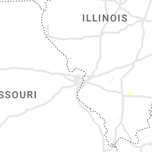
Kansas
| Local Time | Report Details |
|---|---|
| 5:15 PM CDT | Quarter sized hail reported near Saint Francis, KS, 42 miles ESE of Yuma, CO, quarter sized hail at location while with strong winds bending the trees. |
| 5:40 PM CDT | Estimated 60 mph wind gusts reported blowing leaves off trees with torrential rain blowing sideways and causing 50 yd visibilit in cheyenne county KS, 49.5 miles WNW of Colby, KS |
| 5:45 PM CDT | Quarter sized hail reported near Saint Francis, KS, 47.8 miles WNW of Colby, KS, nickel to quarter sized hail reported to have accumulated at location. hail with winds damaged garden at location as well. |
| 5:45 PM CDT | Mesonet station gw1726 st francis airpor in cheyenne county KS, 47.4 miles WNW of Colby, KS |
| 5:45 PM CDT | Report received via social media of an estimated 60 mph wind gust at locatio in cheyenne county KS, 47.8 miles WNW of Colby, KS |
| 5:46 PM CDT | Report from mping: 1-inch tree limbs broke in cheyenne county KS, 47.8 miles WNW of Colby, KS |
| 5:57 PM CDT | Quarter sized hail reported near Saint Francis, KS, 44.8 miles WNW of Colby, KS, dime to quarter size hail... strong northwest winds... 1.50 inches of rain and severe damage to mature wheat... corn... trees and windows. public report via twitter. ti |
| 5:34 PM MDT | Rickety fence blown down by strong winds. time estimated via rada in sherman county KS, 35.8 miles W of Colby, KS |
| 7:29 PM CDT | Mesonet station up840 9.0 w winona (upr in logan county KS, 33.1 miles SW of Colby, KS |
| 7:30 PM CDT | Corrects previous tstm wnd dmg report from winona. report received of several large tree branches downed by wind gusts in winona... ks. a large pine tree was also repor in logan county KS, 25.5 miles SSW of Colby, KS |
| 7:40 PM CDT | Corrects previous non-tstm wnd gst report from 3 sw russell springs. mesonet station ussk1 russell springs 3sw. 10m wind gust measuremen in logan county KS, 36.2 miles SSW of Colby, KS |
| 8:25 PM CDT | Storm damage reported in scott county KS, 49 miles N of Garden City, KS |
| 11:05 PM CDT | Mesonet station up407 0.6 sw hayne (upr in seward county KS, 60 miles S of Garden City, KS |
| 11:06 PM CDT | Mesonet station cw8810 elkhar in morton county KS, 88 miles SW of Garden City, KS |
Kentucky
| Local Time | Report Details |
|---|---|
| 7:10 PM EDT | Sixth and jefferson closed due to wires dow in oldham county KY, 34.1 miles NNE of Louisville, KY |
Florida
| Local Time | Report Details |
|---|---|
| 7:54 PM EDT | Tree down on a power line off of hazel green roa in gadsden county FL, 29.1 miles WNW of Tallahassee, FL |
Texas
| Local Time | Report Details |
|---|---|
| 8:48 PM CDT | Storm damage reported in deaf smith county TX, 46.2 miles ESE of Tucumcari, NM |
| 9:47 PM CDT | Storm damage reported in randall county TX, 20.5 miles SW of Amarillo, TX |
| 9:58 PM CDT | Wtm station gusted to 61 mph at 9:58 pm... then dropped before hitting 58 mph at 10:03 p in randall county TX, 17 miles SSW of Amarillo, TX |
| 10:47 PM CDT | West texas mesonet repor in swisher county TX, 42.8 miles SSE of Amarillo, TX |
| 11:50 PM CDT | West texas mesonet. severe gust along leading edge of thunderstorm outflo in hale county TX, 20.6 miles NNE of Lubbock, TX |
| 12:24 AM CDT | Storm damage reported in ochiltree county TX, 74.2 miles W of Woodward, OK |
| 12:31 AM CDT | Storm damage reported in sherman county TX, 64.4 miles N of Amarillo, TX |
| 12:53 AM CDT | Wt mesonet site had severe gusts from 1253 am cdt to 1255 am cdt... with a peak of 61 mph at 1255 am cd in lipscomb county TX, 58.3 miles WSW of Woodward, OK |
| 1:22 AM CDT | Severe gusts occurred from 122 am cdt through 132 am cdt with a peak of 63 mph at 122 am cd in hemphill county TX, 60.7 miles SW of Woodward, OK |
| 1:25 AM CDT | Severe gusts occurred from 125 am cdt to 140 am cdt with a peak gust of 69 mph at 131 am cd in hemphill county TX, 77.6 miles SW of Woodward, OK |
| 1:29 AM CDT | Severe gusts occurred from 129 am cdt through 141 am cdt with a peak gust of 59 mph at 129 am cd in gray county TX, 56 miles ENE of Amarillo, TX |
| 4:45 AM CDT | Storm damage reported in wichita county TX, 6.1 miles SW of Wichita Falls, TX |
| 4:49 AM CDT | Storm damage reported in clay county TX, 16 miles ENE of Wichita Falls, TX |
| 4:52 AM CDT | Storm damage reported in wichita county TX, 1.7 miles SE of Wichita Falls, TX |
Connect with Interactive Hail Maps