

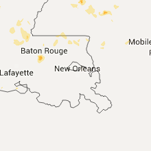
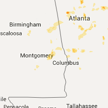
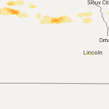
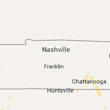
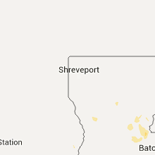
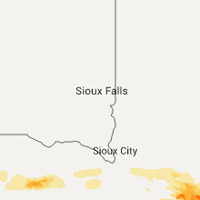
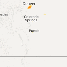
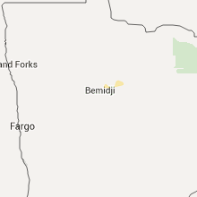
Hail Map for Wednesday, June 24, 2015

Number of Impacted Households on 6/24/2015
0
Impacted by 1" or Larger Hail
0
Impacted by 1.75" or Larger Hail
0
Impacted by 2.5" or Larger Hail
Square Miles of Populated Area Impacted on 6/24/2015
0
Impacted by 1" or Larger Hail
0
Impacted by 1.75" or Larger Hail
0
Impacted by 2.5" or Larger Hail


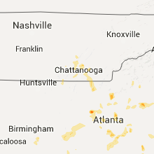


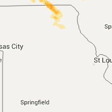


Cities Most Affected by Hail Storms of 6/24/2015
| Hail Size | Demographics of Zip Codes Affected | ||||||
|---|---|---|---|---|---|---|---|
| City | Count | Average | Largest | Pop Density | House Value | Income | Age |
| Guthrie Center, IA | 2 | 1.75 | 1.75 | 16 | $52k | $35.3k | 44.9 |
| Winterset, IA | 2 | 1.75 | 1.75 | 41 | $87k | $37.1k | 40.1 |
| Atlantic, IA | 1 | 2.00 | 2.00 | 52 | $68k | $34.0k | 44.8 |
| Gillette, WY | 1 | 2.00 | 2.00 | 13 | $113k | $55.4k | 31.2 |
| Rozet, WY | 1 | 2.00 | 2.00 | 2 | $87k | $58.0k | 34.6 |
| Fort Mill, SC | 1 | 1.75 | 1.75 | 640 | $0k | $0.0k | 41.4 |
| Pueblo, CO | 1 | 1.75 | 1.75 | 208 | $139k | $47.8k | 37.6 |
| Stuart, IA | 1 | 1.75 | 1.75 | 17 | $81k | $34.4k | 42.8 |
| Saint Charles, IA | 1 | 1.75 | 1.75 | 27 | $103k | $51.4k | 41.3 |
| Great Falls, SC | 1 | 1.75 | 1.75 | 124 | $47k | $29.4k | 41.5 |
| Atlanta, GA | 1 | 1.75 | 1.75 | 2739 | $86k | $32.7k | 33.3 |
Hail and Wind Damage Spotted on 6/24/2015
Filter by Report Type:Hail ReportsWind Reports
States Impacted
Wyoming, Mississippi, Georgia, North Carolina, Tennessee, South Dakota, Florida, South Carolina, Louisiana, Arizona, Colorado, Iowa, Alabama, Michigan, North Dakota, MissouriWyoming
| Local Time | Report Details |
|---|---|
| 9:08 AM MDT | Ping Pong Ball sized hail reported near Rozet, WY, 18.4 miles ESE of Gillette, WY |
| 9:08 AM MDT | Hen Egg sized hail reported near Rozet, WY, 18.4 miles ESE of Gillette, WY |
| 9:48 AM MDT | Quarter sized hail reported near Upton, WY, 34.7 miles ESE of Gillette, WY |
| 11:18 AM MDT | Quarter sized hail reported near Moorcroft, WY, 53.1 miles NNE of Gillette, WY |
| 11:18 AM MDT | Storm damage reported in crook county WY, 53.1 miles NNE of Gillette, WY |
| 11:40 AM MDT | Quarter sized hail reported near Moorcroft, WY, 53.1 miles NNE of Gillette, WY, about 30 trees uprooted... heavy farm equipment rolled over large hatstack leveled. |
| 11:40 AM MDT | About 30 trees uprooted... heavy farm equipment rolled over large hatstack levele in crook county WY, 53.1 miles NNE of Gillette, WY |
| 12:47 PM MDT | Quarter sized hail reported near Aladdin, WY, 60.8 miles NW of Rapid City, SD |
| 7:25 PM MDT | Half Dollar sized hail reported near Douglas, WY, 40.9 miles ESE of Casper, WY |
| 1:10 AM MDT | Hen Egg sized hail reported near Gillette, WY, 39.1 miles SSW of Gillette, WY, cracked windows from hail |
| 2:17 AM MDT | Quarter sized hail reported near Gillette, WY, 53.3 miles SSE of Gillette, WY |
Mississippi
| Local Time | Report Details |
|---|---|
| 12:37 PM CDT | Tree fell onto a telephone line in the myrick communit in jones county MS, 82.1 miles ESE of Jackson, MS |
| 12:46 PM CDT | A tree was blown onto a powerline in laure in jones county MS, 74.1 miles SE of Jackson, MS |
| 1:45 PM CDT | Trees scattered around the county. some were blown down in sumrall and some blown down in the oloh communit in lamar county MS, 71 miles SSE of Jackson, MS |
| 1:46 PM CDT | Trees were blown down along water well road. trees were blown down along elm road and booth lane off of dan easterling road. a tree was blown down onto a powerline on b in covington county MS, 51.1 miles SE of Jackson, MS |
| 1:55 PM CDT | Trees were blown down on booth lane near virgil roa in covington county MS, 54.3 miles SSE of Jackson, MS |
| 2:10 PM CDT | Trees down on highway 541. reported by emergency management in jefferson davis county MS, 48.7 miles SSE of Jackson, MS |
| 2:15 PM CDT | Trees down on highway 13. reported by emergency management in jefferson davis county MS, 48.9 miles SSE of Jackson, MS |
| 2:15 PM CDT | Numerous trees down on white roger road. reported by emergency management in jefferson davis county MS, 49.4 miles SSE of Jackson, MS |
| 2:18 PM CDT | Numerous trees down on grandby road. reported by emergency management in jefferson davis county MS, 53.1 miles SSE of Jackson, MS |
| 2:25 PM CDT | Powerlines down near airport road and johns street. reported by emergency management in jefferson davis county MS, 51.7 miles SSE of Jackson, MS |
| 2:30 PM CDT | Numerous trees down on grandby road. reported by emergency management in jefferson davis county MS, 53.1 miles SSE of Jackson, MS |
| 2:30 PM CDT | Numerous trees down on white roger road. reported by emergency management in jefferson davis county MS, 49.4 miles SSE of Jackson, MS |
| 2:36 PM CDT | Powerline was blown dow in grenada county MS, 57 miles WNW of Starkville, MS |
| 2:44 PM CDT | A few trees were blown dow in simpson county MS, 39.6 miles SE of Jackson, MS |
| 2:44 PM CDT | Trees down along hwy 541 south near the simpson and jefferson davis county lin in simpson county MS, 42.7 miles SSE of Jackson, MS |
| 2:56 PM CDT | A few trees down on cub brown road and benson roa in lawrence county MS, 48.8 miles S of Jackson, MS |
| 3:09 PM CDT | A few trees down in simpson county MS, 22.8 miles SSE of Jackson, MS |
| 3:10 PM CDT | Stone county ema reports a tree down that knocked out power next to a residence on highway 26 on the west side of wiggin in stone county MS, 65.6 miles W of Mobile, AL |
| 3:10 PM CDT | Stone county ema reports a tree down on college ave and another down over auburn st in wiggin in stone county MS, 65.7 miles W of Mobile, AL |
| 3:10 PM CDT | Numerous trees down in the georgetown area. reported by public in copiah county MS, 29.6 miles S of Jackson, MS |
| 3:20 PM CDT | Numerous trees down in the hopewell community. reported by emergency management in copiah county MS, 28.3 miles S of Jackson, MS |
| 3:35 PM CDT | Numerous trees down around hazlehurst. reported by emergency management in copiah county MS, 32.6 miles SSW of Jackson, MS |
| 3:40 PM CDT | A few trees down in wesson. reported by emergency management in copiah county MS, 43.2 miles SSW of Jackson, MS |
| 3:53 PM CDT | Tree blown down blocking both lanes of traffic at hwy 53 and cc camp roa in harrison county MS, 65.9 miles NE of New Orleans, LA |
| 3:53 PM CDT | Tree down in blaine. reported by sherif in sunflower county MS, 92.5 miles NNW of Jackson, MS |
| 3:53 PM CDT | Several limbs down. tin peeled off a roof. reported by public in sunflower county MS, 91 miles NNW of Jackson, MS |
| 3:55 PM CDT | A few trees were down near the tomnolen are in webster county MS, 31.8 miles W of Starkville, MS |
| 4:00 PM CDT | Tree fell across railroad tracks halting train traffi in pontotoc county MS, 61.6 miles N of Starkville, MS |
| 4:24 PM CDT | Tree down blocking one lane of road near wolf river road and cable bridge roa in harrison county MS, 60 miles NE of New Orleans, LA |
| 4:25 PM CDT | Quarter sized hail reported near Jackson, MS, 2.3 miles NW of Jackson, MS, reported in northeast jackson. relayed via social media. |
| 4:30 PM CDT | Powerlines down near intersection of redland sarepta road and highway 15 in pontotoc county MS, 44 miles NNW of Starkville, MS |
| 4:30 PM CDT | Several trees and numerous tree limbs were snapped and blown down in north jackson. report via social medi in hinds county MS, 2.3 miles NW of Jackson, MS |
| 4:40 PM CDT | Trees down in isol in humphreys county MS, 70.4 miles NNW of Jackson, MS |
| 5:01 PM CDT | A few trees were blown dow in yazoo county MS, 40.9 miles NNW of Jackson, MS |
| 5:01 PM CDT | Trees and powerlines were blown down near highway 16 and old highway 1 in yazoo county MS, 37.1 miles N of Jackson, MS |
| 5:07 PM CDT | Powerlines down near intersection of perry road and indian mound road in tunica county MS, 32.8 miles SW of Memphis, TN |
| 5:18 PM CDT | Trees were blown down across the road at hwy 22 and stokes roa in madison county MS, 18.5 miles NNW of Jackson, MS |
| 5:22 PM CDT | A tree was blown down on top of a car on hwy 433 near bentonia gibbs school. trees and powerlines were blown down near martin road and hwy 43 in yazoo county MS, 27.1 miles NNW of Jackson, MS |
Georgia
| Local Time | Report Details |
|---|---|
| 2:33 PM EDT | Public submitted a report of several snapped trees...one being a 60 foot elm tree. many smaller limbs also fell to the groun in gwinnett county GA, 32.8 miles ENE of Atlanta, GA |
| 2:40 PM EDT | A member of the public reported a few trees down along dacula road and auburn roa in gwinnett county GA, 33.8 miles NE of Atlanta, GA |
| 2:45 PM EDT | Marietta asos recorded a gust of 62 mph associated with severe warned storm in the are in cobb county GA, 16.6 miles NNW of Atlanta, GA |
| 3:01 PM EDT | Quarter sized hail reported near Bremen, GA, 43.7 miles W of Atlanta, GA, james o neil chrysler dodge jeep in bremen reported quarter size hail at their location along highway 27. |
| 3:01 PM EDT | James o neil chrysler dodge jeep in bremen reported quarter size hail at their location along highway 2 in haralson county GA, 43.7 miles W of Atlanta, GA |
| 3:01 PM EDT | Trees and powerlines down off of connector rd in rabun county GA, 46.7 miles W of Greenville, SC |
| 3:14 PM EDT | Few trees down and pea sized hail in lakemont in rabun county GA, 46.7 miles W of Greenville, SC |
| 3:25 PM EDT | Several trees down. one inch hail also reporte in mcduffie county GA, 29.9 miles W of Augusta, GA |
| 3:30 PM EDT | Quarter sized hail reported near Duluth, GA, 22.6 miles NE of Atlanta, GA, public reported quarter size hail in downtown duluth right around 330pm. |
| 3:50 PM EDT | A tree was blown down at hwy 78 and new hope rd in betwee in walton county GA, 33.8 miles E of Atlanta, GA |
| 3:53 PM EDT | A tree was blown down on powerlines at hillside drive and grayson hw in gwinnett county GA, 26.7 miles ENE of Atlanta, GA |
| 3:54 PM EDT | A tree and power lines were blown down at hwy 138 and nunnally farm r in walton county GA, 34.6 miles E of Atlanta, GA |
| 4:00 PM EDT | Power outages throughout much of the city of toccoa. trees down on big a road and collins road. time estimated from rada in stephens county GA, 44.5 miles WSW of Greenville, SC |
| 4:00 PM EDT | Golf Ball sized hail reported near Atlanta, GA, 5.5 miles SSW of Atlanta, GA, emergency manager received report of hail of varying size...up to golf balls in the laurels subdivision off of highway 20 in the vicinity of east point |
| 4:00 PM EDT | A tree was blown down on a house on nathan court in lilbur in gwinnett county GA, 21.6 miles ENE of Atlanta, GA |
| 4:04 PM EDT | Several 4 inch diameter limbs down...also pea size hai in stephens county GA, 44.5 miles WSW of Greenville, SC |
| 4:06 PM EDT | Wind gust of 61 mph was measured at hartsfield-jackson airpor in clayton county GA, 7.8 miles SSW of Atlanta, GA |
| 4:14 PM EDT | Several trees blown down locke roa in habersham county GA, 57.4 miles WSW of Greenville, SC |
| 4:28 PM EDT | A few trees knocked down on chase roa in habersham county GA, 57.4 miles WSW of Greenville, SC |
| 4:30 PM EDT | Multiple trees were blown down across hall count in hall county GA, 53.3 miles NE of Atlanta, GA |
| 4:35 PM EDT | A tree was blown down onto i-85 at virginia avenu in fulton county GA, 6.5 miles SSW of Atlanta, GA |
| 4:43 PM EDT | Quarter sized hail reported near Social Circle, GA, 41.4 miles ESE of Atlanta, GA, quarter size hail se of social circle near i-20. |
| 4:49 PM EDT | 911 call center has received several reports of trees down...estimated at least 5....scattered across the western portion of spalding county. some of these trees have b in spalding county GA, 32.3 miles S of Atlanta, GA |
| 4:55 PM EDT | Tree down across roadway at highway 2 and lake kathy roa in whitfield county GA, 19.8 miles ESE of Chattanooga, TN |
| 5:00 PM EDT | Tree down across old chattanooga road near rocky fac in whitfield county GA, 22.7 miles SE of Chattanooga, TN |
| 5:00 PM EDT | County comms reported one small tree down on bold springs r in franklin county GA, 56.3 miles SW of Greenville, SC |
| 5:06 PM EDT | A tree was blown onto a power line on mccullar weaver r in baldwin county GA, 81 miles SE of Atlanta, GA |
| 5:20 PM EDT | Trees and power lines were blown down on tibbs bridge rd as well as greeson bend r in murray county GA, 34 miles SE of Chattanooga, TN |
| 5:25 PM EDT | Trees and power lines were blown down on smyrna church r in murray county GA, 36.7 miles SE of Chattanooga, TN |
| 5:45 PM EDT | Nws survey determined a downburst knocked 25 to 30 large pine trees down on mobile homes in the whispering pines mobile home par in fayette county GA, 23.8 miles SSW of Atlanta, GA |
| 5:56 PM EDT | A tree was blown down at the intersection of aw roberts dr and strippling st in cherokee county GA, 40.8 miles N of Atlanta, GA |
| 5:56 PM EDT | A large tree was blown down onto a house at the intersection of aw roberts dr and strippling st in cherokee county GA, 40.8 miles N of Atlanta, GA |
| 5:56 PM EDT | Public reported 58 mph wind gust and nickle sized hai in cherokee county GA, 39.4 miles N of Atlanta, GA |
| 6:00 PM EDT | Two trees were blown down at intersection of howell bridge rd and old howell bridge r in cherokee county GA, 40.1 miles N of Atlanta, GA |
| 6:02 PM EDT | Two trees were blown down onto a power line at the intersection of pea ridge rd and flatrock r in putnam county GA, 71.1 miles ESE of Atlanta, GA |
| 6:02 PM EDT | A tree fell and blocked northridge rd at ball ground highwa in cherokee county GA, 39.4 miles N of Atlanta, GA |
| 6:02 PM EDT | Tree down on power line at intersection of cokers chapel rd and east cherokee dr in cherokee county GA, 37.3 miles N of Atlanta, GA |
| 6:15 PM EDT | Quarter sized hail reported near Cumming, GA, 43.2 miles NNE of Atlanta, GA, 911 call center has received report of hail up to quarter size near the forsyth and dawson county border...in the vicinity of ga 400 near silver city. |
| 6:25 PM EDT | 911 call center has received reports of numerous trees down across the count in bartow county GA, 37.4 miles NW of Atlanta, GA |
| 6:40 PM EDT | 911 call center received several reports of numerous trees down...at least 10...across the county within the warned stor in gordon county GA, 45.2 miles SE of Chattanooga, TN |
| 6:41 PM EDT | Quarter sized hail reported near Cartersville, GA, 41.1 miles NW of Atlanta, GA, quarter sized hail report from johnny mitchells smokehouse. |
| 6:45 PM EDT | 911 call center received a report of a downed tree in north dawson count in dawson county GA, 57.3 miles N of Atlanta, GA |
| 6:48 PM EDT | 911 call center received a report of a downed tree on kerry drive just to the south/southeast of downtown jaspe in pickens county GA, 49.8 miles N of Atlanta, GA |
| 7:00 PM EDT | Harris county 911 call center has received reports of numerous trees down...between 10-12 at least...dispersed mostly across the waverly hall are in harris county GA, 43.5 miles E of Auburn, AL |
| 7:11 PM EDT | Tree down on adel highway outside of morve in brooks county GA, 56.3 miles SW of Douglas, GA |
| 7:35 PM EDT | Tree downed on dillon roa in thomas county GA, 39.3 miles NE of Tallahassee, FL |
| 7:35 PM EDT | Tree downed on a vehicle in thomasvill in thomas county GA, 32.9 miles NNE of Tallahassee, FL |
| 7:40 PM EDT | Several reports of trees down around the city of thomasvill in thomas county GA, 34.7 miles NNE of Tallahassee, FL |
| 7:45 PM EDT | About a dozen large trees were blown down in columbus...some onto power line in muscogee county GA, 30.4 miles ESE of Auburn, AL |
| 7:45 PM EDT | About a dozen large trees were blown down in columbus...some onto power line in muscogee county GA, 31.7 miles ESE of Auburn, AL |
North Carolina
| Local Time | Report Details |
|---|---|
| 2:50 PM EDT | Couple trees dow in clay county NC, 63 miles S of Knoxville, TN |
| 4:00 PM EDT | Eoc report relayed via social media of multiple trees and lines down on ebci land in northern jackson count in jackson county NC, 49.4 miles SE of Knoxville, TN |
| 6:02 PM EDT | Reports of several trees blown dow in gaston county NC, 28.3 miles WNW of Charlotte, NC |
| 6:15 PM EDT | Many large limbs blown down and nickel size hai in mecklenburg county NC, 10.3 miles SSW of Charlotte, NC |
| 6:22 PM EDT | County call center reports several trees blown dow in gaston county NC, 26.2 miles W of Charlotte, NC |
| 6:30 PM EDT | Power line down near s park rd and tyvola rd...causing failure of traffic ligh in mecklenburg county NC, 5 miles S of Charlotte, NC |
| 8:20 PM EDT | Quarter sized hail reported near Whiteville, NC, 44.8 miles WNW of Wilmington, NC, pea to quarter size hail |
| 8:40 PM EDT | Report of tree fallen on powerlin in bladen county NC, 30.7 miles WNW of Wilmington, NC |
| 8:55 PM EDT | Many trees and powerlines down across the northwest part of the count in catawba county NC, 46.9 miles NW of Charlotte, NC |
| 9:05 PM EDT | Tree blown down on house on 26th av in catawba county NC, 45.2 miles NW of Charlotte, NC |
| 9:28 PM EDT | Report of tree down in roadway on blackwell rd. time estimated by rada in columbus county NC, 53.6 miles W of Wilmington, NC |
Tennessee
| Local Time | Report Details |
|---|---|
| 2:00 PM CDT | Trees and power lines down along hwy 127 near the sequatchie / bledsoe county lin in sequatchie county TN, 25.8 miles N of Chattanooga, TN |
| 2:51 PM CDT | A tree was blown down in the town of finle in dyer county TN, 54.2 miles W of Mc Kenzie, TN |
| 3:00 PM CDT | Numerous trees down countywid in sequatchie county TN, 22.8 miles NNW of Chattanooga, TN |
| 4:05 PM EDT | Several trees and power lines down near hixson pike at longview driv in hamilton county TN, 3.2 miles ENE of Chattanooga, TN |
| 5:00 PM EDT | Few trees down along bates pik in bradley county TN, 29.9 miles ENE of Chattanooga, TN |
South Dakota
| Local Time | Report Details |
|---|---|
| 1:22 PM MDT | Quarter sized hail reported near Spearfish, SD, 42.5 miles NW of Rapid City, SD, also measured a 39mph wind gust. relayed via spotternetwork |
Florida
| Local Time | Report Details |
|---|---|
| 3:39 PM EDT | Several trees down in the city of gainesville. time estimated by rada in alachua county FL, 62.5 miles SW of Jacksonville, FL |
| 5:10 PM EDT | Trees and powerlines down on country club rd. time estimated by rada in columbia county FL, 58.3 miles WSW of Jacksonville, FL |
| 5:10 PM EDT | Two houses damaged by falling tree in columbia county FL, 59.7 miles W of Jacksonville, FL |
| 6:33 PM EDT | Tree and power pole blown down near 100 north dancy stree in st. johns county FL, 43.7 miles SSE of Jacksonville, FL |
| 7:03 PM CDT | Via west florida electric cooperative facebook page...a tree fell on a three phase power line and knocked out power in the sneads area to approximately 400 customer in jackson county FL, 42.4 miles WNW of Tallahassee, FL |
South Carolina
| Local Time | Report Details |
|---|---|
| 4:40 PM EDT | Aiken county sheriff reported powerlines down on ascauga lake road in graniteville in aiken county SC, 10.9 miles NE of Augusta, GA |
| 5:10 PM EDT | Quarter sized hail reported near New Ellenton, SC, 17 miles ESE of Augusta, GA, quarter sized hail in new ellenton. |
| 6:10 PM EDT | Golf Ball sized hail reported near Fort Mill, SC, 13.4 miles S of Charlotte, NC, police officer reported golf ball size hail and trees and power lines down on harrisburg rd |
| 6:18 PM EDT | Tin roof partially blown off a business. many limbs knocked down and nickle hai in york county SC, 15.8 miles SSW of Charlotte, NC |
| 6:35 PM EDT | Batesburg-leeesville police reported trees down on sussex road/lee street in lexington county SC, 39.5 miles NE of Augusta, GA |
| 6:40 PM EDT | Quarter sized hail reported near Rock Hill, SC, 19.8 miles SSW of Charlotte, NC, quarter hail near the intersection of i-77 and dave lyle blvd. |
| 6:50 PM EDT | Quarter sized hail reported near Fort Mill, SC, 16.2 miles SSW of Charlotte, NC, public reports quarter size hail. |
| 6:50 PM EDT | Three large trees blown dow in york county SC, 16.2 miles SSW of Charlotte, NC |
| 7:00 PM EDT | Ping Pong Ball sized hail reported near Rock Hill, SC, 20.3 miles SSW of Charlotte, NC, ping pong size hail and a few small brances knocked down. |
| 7:08 PM EDT | Fairfield county sheriff reported trees down at landis road and kennedy roa in fairfield county SC, 67.2 miles SSW of Charlotte, NC |
| 7:14 PM EDT | 2 trees down near peak in newberry county SC, 62.9 miles NNE of Augusta, GA |
| 7:15 PM EDT | Newberry county sheriff reported trees down at sc highway 213 and us 176 near pomari in newberry county SC, 62.9 miles NNE of Augusta, GA |
| 7:17 PM EDT | Quarter sized hail reported near Rock Hill, SC, 22.3 miles SSW of Charlotte, NC, report of quarter size hail on india hook road next to lake wylie. |
| 7:20 PM EDT | Golf Ball sized hail reported near Great Falls, SC, 48.2 miles S of Charlotte, NC, gas station attendant near sr 200 and us 21 stated that a customer had reported golf ball size hail near mitford. time estimated. |
| 7:25 PM EDT | A few trees blown dow in york county SC, 20.5 miles SSW of Charlotte, NC |
| 7:35 PM EDT | Sc highway patrol reported trees down on queen chapel road and ferrell road/brewington road. wind gust to 48 mph at the sumter municipal airpor in sumter county SC, 58.7 miles NNW of Charleston, SC |
| 7:45 PM EDT | Sc highway patrol reported trees down at oswego highway and pike road/highway 76 in sumter county SC, 54.2 miles NNW of Charleston, SC |
| 9:25 PM EDT | Sc highway patrol reported trees down on us 76 near sumter/richland county line in sumter county SC, 62.6 miles NNW of Charleston, SC |
| 11:07 PM EDT | Sc highway patrol reported trees down along highway 641 and sycamore driv in bamberg county SC, 60 miles ESE of Augusta, GA |
| 11:36 PM EDT | Sheriff dispatch reported trees down in the area of clear pond road and highway 60 in bamberg county SC, 58.2 miles ESE of Augusta, GA |
| 12:36 AM EDT | Trained spotter reported a tree down on hwy 176 in the vicinity of brandywine apartment in berkeley county SC, 12.9 miles S of Charleston, SC |
| 12:40 AM EDT | 66 mph gust and 44 mph sustained recorded by a davis vantage pro2 sensor at liberty hall plantatio in berkeley county SC, 12.9 miles S of Charleston, SC |
| 12:42 AM EDT | Sc highway patrol reports a tree down and in the roadway on snake river road near the intersection with foster creek road. time estimated from rada in berkeley county SC, 15 miles S of Charleston, SC |
| 1:13 AM EDT | Social media reports tree limbs down on power lines on waterway blv in charleston county SC, 30.7 miles SSE of Charleston, SC |
| 1:16 AM EDT | Sc highway patrol reports tree down on interstate 26 eastbound at mile marker 194 near jedburg r in berkeley county SC, 14 miles SW of Charleston, SC |
| 1:23 AM EDT | Quarter sized hail reported near Isle Of Palms, SC, 30.2 miles SE of Charleston, SC, quarter-size hail reported on dewees island. |
Louisiana
| Local Time | Report Details |
|---|---|
| 4:07 PM CDT | A few trees were downed between pine and franklinto in washington county LA, 63.8 miles N of New Orleans, LA |
| 6:30 PM CDT | A few trees down along hwy 80 in madison county LA, 52.5 miles ESE of Bastrop, LA |
| 6:30 PM CDT | Power lines down in town in east carroll county LA, 42.8 miles E of Bastrop, LA |
| 6:30 PM CDT | Power lines down in east carroll county LA, 43.6 miles E of Bastrop, LA |
| 7:22 PM CDT | Trees down in richland county LA, 25.4 miles SE of Bastrop, LA |
| 7:30 PM CDT | Scattered trees and power lines down across the entire parish with no concentrated areas of damage...reported by richland parish so in richland county LA, 23.1 miles SSE of Bastrop, LA |
| 8:00 PM CDT | Large tree down on the road at intersection of whites ferry rd and wall williams r in ouachita county LA, 20.7 miles SW of Bastrop, LA |
| 9:30 PM CDT | Evangeline parish dispatch received reports of trees down between turkey creek and bayou chicot. time based on radar dat in evangeline county LA, 50.8 miles NNW of Lafayette, LA |
Arizona
| Local Time | Report Details |
|---|---|
| 2:35 PM MST | Storm damage reported in navajo county AZ, 2.3 miles NE of Show Low, AZ |
| 3:36 PM MST | Safford asos recorded a 61 mph wind gust from the ene at 2236 ut in graham county AZ, 79 miles W of Silver City, NM |
Colorado
| Local Time | Report Details |
|---|---|
| 4:33 PM MDT | Golf Ball sized hail reported near Pueblo, CO, 8.8 miles WNW of Pueblo, CO |
| 4:48 PM MDT | Potential brief tornado touchdown near 10th and elmira. a few trees uprooted along with roof material tossed onto street and against other structure in arapahoe county CO, 9.7 miles E of Denver, CO |
| 4:48 PM MDT | Significant damage to large trees with a few toppled onto streets in the 23rd and galena vicinit in arapahoe county CO, 9.7 miles E of Denver, CO |
| 4:50 PM MDT | Quarter sized hail reported near Denver, CO, 2.7 miles SE of Denver, CO |
| 4:58 PM MDT | Quarter sized hail reported near Denver, CO, 1.8 miles ESE of Denver, CO |
| 5:02 PM MDT | Quarter sized hail reported near Denver, CO, 6.9 miles ENE of Denver, CO, denver upper air site |
| 5:16 PM MDT | Ping Pong Ball sized hail reported near Denver, CO, 4.4 miles SE of Denver, CO |
| 5:20 PM MDT | Quarter sized hail reported near Aurora, CO, 16.4 miles ESE of Denver, CO |
| 7:29 PM MDT | Significant damage to large trees with a few toppled onto streets in the 23rd and galena vicinit in arapahoe county CO, 9.7 miles E of Denver, CO |
| 7:34 PM MDT | Approximate 5 inch diameter limb down on live tree in mesa county CO, 3.6 miles SE of Grand Junction, CO |
| 8:02 PM MDT | Potential brief tornado touchdown near 10th and elmira. a few trees uprooted along with roof material tossed onto street and against other structure in arapahoe county CO, 9.7 miles E of Denver, CO |
Iowa
| Local Time | Report Details |
|---|---|
| 6:22 PM CDT | Quarter sized hail reported near Yale, IA, 38 miles WNW of Des Moines, IA, reported quarter sized hail at his home |
| 6:54 PM CDT | Ping Pong Ball sized hail reported near Guthrie Center, IA, 46.2 miles W of Des Moines, IA, several large trees down. 1 to 2 inch diameter hail. time estimated by radar. |
| 7:05 PM CDT | Spotter reported estimated 80mph wind gusts at their home in guthrie county IA, 35.9 miles W of Des Moines, IA |
| 7:07 PM CDT | Golf Ball sized hail reported near Guthrie Center, IA, 46.2 miles W of Des Moines, IA, spotter reported 1.75 inch hail at his home |
| 7:09 PM CDT | Golf Ball sized hail reported near Guthrie Center, IA, 48.7 miles W of Des Moines, IA, along highway 44. from guthrie county emergency management |
| 7:13 PM CDT | 60 mph or higher wind gust...7 south of panora on wagon rd. ongoin in guthrie county IA, 36.5 miles W of Des Moines, IA |
| 7:21 PM CDT | Golf Ball sized hail reported near Stuart, IA, 38.6 miles W of Des Moines, IA |
| 7:22 PM CDT | Quarter sized hail reported near Elk Horn, IA, 51.1 miles ENE of Omaha, NE, nickel to quarter size hail. |
| 7:24 PM CDT | Power lines down in menlo - winds estimated between 50-55 mph or higher. large hail also being reported at 732 pm in guthrie county IA, 40.9 miles W of Des Moines, IA |
| 7:32 PM CDT | Half Dollar sized hail reported near Redfield, IA, 30.3 miles W of Des Moines, IA |
| 7:33 PM CDT | Hen Egg sized hail reported near Atlantic, IA, 55.1 miles ENE of Omaha, NE |
| 7:40 PM CDT | Power lines down in madison county IA, 27 miles WSW of Des Moines, IA |
| 7:54 PM CDT | 8 to 10 inch limbs snapped off tree in guthrie county IA, 40.6 miles W of Des Moines, IA |
| 8:01 PM CDT | Quarter sized hail reported near Earlham, IA, 26.6 miles W of Des Moines, IA, pea to quarter sized hail with 55 mph winds. |
| 8:09 PM CDT | Quarter sized hail reported near Winterset, IA, 27.2 miles SW of Des Moines, IA |
| 8:10 PM CDT | Quarter sized hail reported near Adair, IA, 53.5 miles W of Des Moines, IA, as well as just west of adair. from guthrie county emergency manager |
| 8:10 PM CDT | Golf Ball sized hail reported near Winterset, IA, 26.3 miles SW of Des Moines, IA, spotter reported golf ball sized hail just north of winterset |
| 8:10 PM CDT | Spotter reported estimated 60mph winds just north of winterset in madison county IA, 26.3 miles SW of Des Moines, IA |
| 8:13 PM CDT | Golf Ball sized hail reported near Winterset, IA, 24.5 miles SW of Des Moines, IA, between winteset and patterson along highway 92 |
| 8:14 PM CDT | Quarter sized hail reported near Adel, IA, 20.6 miles W of Des Moines, IA, spotter reported quarter sized hail at home just north of de soto |
| 8:30 PM CDT | Quarter sized hail reported near New Virginia, IA, 28.9 miles SSW of Des Moines, IA |
| 8:40 PM CDT | Quarter sized hail reported near Marshalltown, IA, 46.8 miles NE of Des Moines, IA |
| 8:42 PM CDT | Golf Ball sized hail reported near Saint Charles, IA, 23 miles SSW of Des Moines, IA |
| 9:05 PM CDT | Visibility with torrential rai in clarke county IA, 37.3 miles SSW of Des Moines, IA |
| 9:11 PM CDT | Wall cloud reported. power flashes reported in or near osceola - possibly strong wind in clarke county IA, 42.2 miles S of Des Moines, IA |
| 9:30 PM CDT | Measured at the chariton airport in lucas county IA, 41.5 miles SSE of Des Moines, IA |
| 9:33 PM CDT | Spotter reported whole trees...4 to 6 inch branches...and power poles down on the north side of chariton by the medical center...time radar estimate in lucas county IA, 42 miles SSE of Des Moines, IA |
| 9:35 PM CDT | Numerous trees down in tow in lucas county IA, 42.4 miles SSE of Des Moines, IA |
| 10:02 PM CDT | Quarter sized hail reported near Bagley, IA, 41.7 miles WNW of Des Moines, IA, hail ongoing at this time |
| 10:19 PM CDT | Quarter sized hail reported near Shellsburg, IA, 12.8 miles NW of Cedar Rapids, IA |
| 10:32 PM CDT | Half Dollar sized hail reported near Center Point, IA, 15.7 miles NNW of Cedar Rapids, IA, relayed by kcrg-tv through viewer picture on social media. |
| 11:00 PM CDT | Quarter sized hail reported near Central City, IA, 18 miles NNE of Cedar Rapids, IA |
| 12:23 AM CDT | Quarter sized hail reported near Booneville, IA, 14.5 miles WSW of Des Moines, IA, public reported quarter sized hail in booneville...via social media |
| 12:27 AM CDT | Report by pecan project in des moines county IA, 37.2 miles NE of Kahoka, MO |
Alabama
| Local Time | Report Details |
|---|---|
| 6:47 PM CDT | Trees and powerlines down near county 158 and lee road 638 in lee county AL, 18.1 miles ENE of Auburn, AL |
| 6:50 PM CDT | Sporadic trees and powerlines down in smiths station. locations include along county 296 and also along county 23 in lee county AL, 22.3 miles ESE of Auburn, AL |
| 6:52 PM CDT | Sporadic trees and powerlines down in the phenix city area including along county road 553 in lee county AL, 25.9 miles ESE of Auburn, AL |
| 7:38 PM CDT | Quarter sized hail reported near Heflin, AL, 66.5 miles N of Auburn, AL, along county 19 |
| 7:43 PM CDT | Trees down along county 19 in cleburne county AL, 66.5 miles N of Auburn, AL |
| 7:48 PM CDT | Quarter sized hail reported near Auburn, AL, 6.1 miles WSW of Auburn, AL, quarter size hail near county 10 and wire rd |
| 7:48 PM CDT | Trees down near county 39 and state highway 15 in macon county AL, 13.5 miles W of Auburn, AL |
| 8:02 PM CDT | Three trees down along abel road in clay county AL, 61.3 miles E of Birmingham, AL |
| 8:55 PM CDT | Awning blown off of shrimp basket restaurant at the corner of vaughn and taylor in montgomery in montgomery county AL, 44.8 miles WSW of Auburn, AL |
| 9:00 PM CDT | Trees and powerlines down on at least 10 streets in montgomery in montgomery county AL, 49.9 miles WSW of Auburn, AL |
| 9:36 PM CDT | Tree down along county 2. also a powerline down on highway 9 in lowndes county AL, 39.9 miles ENE of Camden, AL |
| 10:37 PM CDT | Line of thunderstorms blew down trees along al-41 near the dallas county lin in wilcox county AL, 7.5 miles NE of Camden, AL |
| 10:50 PM CDT | Thunderstorm winds blew down trees along kennedy street in the city of camde in wilcox county AL, 2.1 miles NW of Camden, AL |
Michigan
| Local Time | Report Details |
|---|---|
| 9:06 PM EDT | Quarter sized hail reported near Nisula, MI, 66.2 miles WNW of Marquette, MI, delayed report via social media. |
North Dakota
| Local Time | Report Details |
|---|---|
| 8:08 PM MDT | Half Dollar sized hail reported near Beulah, ND, 56 miles WNW of Bismarck, ND, quarter to half dollar size hail 2 miles south of beulah. little wind with the hail. |
Missouri
| Local Time | Report Details |
|---|---|
| 11:02 PM CDT | Quarter sized hail reported near Lancaster, MO, 43.3 miles W of Kahoka, MO |
Connect with Interactive Hail Maps