

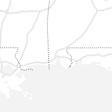
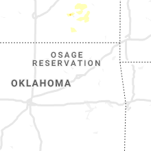
Hail Map for Friday, June 26, 2020

Number of Impacted Households on 6/26/2020
0
Impacted by 1" or Larger Hail
0
Impacted by 1.75" or Larger Hail
0
Impacted by 2.5" or Larger Hail
Square Miles of Populated Area Impacted on 6/26/2020
0
Impacted by 1" or Larger Hail
0
Impacted by 1.75" or Larger Hail
0
Impacted by 2.5" or Larger Hail

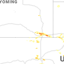


Cities Most Affected by Hail Storms of 6/26/2020
| Hail Size | Demographics of Zip Codes Affected | ||||||
|---|---|---|---|---|---|---|---|
| City | Count | Average | Largest | Pop Density | House Value | Income | Age |
| Colorado Springs, CO | 3 | 2.00 | 2.50 | 220 | $248k | $85.6k | 38.4 |
| Fleming, CO | 2 | 1.88 | 2.00 | 2 | $80k | $32.7k | 44.1 |
| Peetz, CO | 2 | 1.88 | 2.00 | 1 | $52k | $38.8k | 46.0 |
| Sedgwick, CO | 1 | 2.75 | 2.75 | 1 | $50k | $29.4k | 50.6 |
| Crook, CO | 1 | 2.75 | 2.75 | 1 | $53k | $26.0k | 50.8 |
| Peyton, CO | 1 | 1.75 | 1.75 | 127 | $173k | $54.4k | 36.2 |
| Miltonvale, KS | 1 | 1.75 | 1.75 | 4 | $26k | $26.7k | 43.2 |
| Wray, CO | 1 | 1.75 | 1.75 | 5 | $72k | $33.4k | 39.1 |
Hail and Wind Damage Spotted on 6/26/2020
Filter by Report Type:Hail ReportsWind Reports
States Impacted
Iowa, Illinois, Colorado, Wisconsin, Wyoming, Alabama, Maine, Ohio, Texas, Utah, New Mexico, Michigan, Indiana, Kansas, Nebraska, MissouriIowa
| Local Time | Report Details |
|---|---|
| 12:25 PM CDT | Quarter sized hail reported near Lime Springs, IA, 50.9 miles ENE of Mason City, IA |
| 12:25 PM CDT | Trained spotter reported 60 to 70 mph wind gusts and quarter size hai in howard county IA, 50.9 miles ENE of Mason City, IA |
| 12:25 PM CDT | Public reports tree damage just north of lime springs and broadcast media reports power outage outside of lime spring in howard county IA, 51.2 miles ENE of Mason City, IA |
| 1:44 PM CDT | Corrects previous non-tstm wnd gst report from waucoma. private weather station reported a 67 mph wind gust. time estimat in fayette county IA, 59.5 miles E of Mason City, IA |
| 6:35 PM CDT | Heavy wooden outdoor dog crate that was blown across the yard. estimated winds at 60-65 mp in van buren county IA, 32.5 miles NNW of Kahoka, MO |
| 7:13 PM CDT | 4-6 inch limbs down and power is ou in henry county IA, 38.7 miles NNE of Kahoka, MO |
Illinois
| Local Time | Report Details |
|---|---|
| 2:55 PM CDT | Corrects previous report from sleepy hollow. damage occurred with a storm during the early afternoon. at least two utility poles were snapped. time estimate in kane county IL, 37.7 miles WNW of Chicago, IL |
| 5:20 PM CDT | Ping Pong Ball sized hail reported near Oregon, IL, 73.5 miles S of Madison, WI, time and location estimated. |
| 5:30 PM CDT | Corrects previous tstm wnd dmg report from 1 w warren. large tree down that was somewhat rotted through... but estimated winds to be 55-60 mp in jo daviess county IL, 50.4 miles SW of Madison, WI |
| 5:45 PM CDT | Sheriff reports trees down near castle rock state park in the brooks island are in ogle county IL, 75.5 miles S of Madison, WI |
| 6:01 PM CDT | Report of large trees down received via social media. time estimated based on rada in de kalb county IL, 56.5 miles WNW of Chicago, IL |
| 6:08 PM CDT | Numerous large tree limbs blown down near freed and peach roads. time estimate in de kalb county IL, 56.2 miles W of Chicago, IL |
| 6:09 PM CDT | Report of numerous trees down between sycamore and genoa with a utility pole on fire. time and location estimated based on rada in de kalb county IL, 54.8 miles W of Chicago, IL |
| 6:10 PM CDT | Trees down... including one on a house... in castellan subdivision. power also out in nelson are in lee county IL, 78.6 miles N of Peoria, IL |
| 6:20 PM CDT | Storm damage reported in kane county IL, 42.1 miles WNW of Chicago, IL |
| 6:22 PM CDT | Large tree down that was somewhat rotted through... but estimated winds to be 55-60 mp in jo daviess county IL, 50.4 miles SW of Madison, WI |
| 6:23 PM CDT | At least two utility poles were snapped. time estimate in kane county IL, 37.7 miles WNW of Chicago, IL |
| 6:26 PM CDT | Report from mping: 1-inch tree limbs broken; shingles blown of in kane county IL, 42.8 miles WNW of Chicago, IL |
| 6:30 PM CDT | Kane co ares spotter report - campton hills near burlington and empire... power out with large tree branches (maple) and small trees down. time estimated based on radar in kane county IL, 40.4 miles W of Chicago, IL |
| 6:34 PM CDT | Numerous trees 1 to 2 foot in diameter were blown down near morgan and homer streets. time estimate in kane county IL, 35.2 miles WNW of Chicago, IL |
| 6:34 PM CDT | A 1 foot diameter tree was blown down onto a house on oak stree in kane county IL, 35.3 miles WNW of Chicago, IL |
| 6:44 PM CDT | Spotter network report of a roughly 6 inch diameter tree limb down on a car. time estimated b in cook county IL, 29.5 miles WNW of Chicago, IL |
| 6:47 PM CDT | Wind gusts estimated between 50 mph and 60 mp in cook county IL, 25.2 miles WNW of Chicago, IL |
| 6:47 PM CDT | A large tree was snapped along maple avenue. time estimate in dupage county IL, 24.5 miles WNW of Chicago, IL |
| 6:51 PM CDT | Measured gust to 71 mph near route 53 and route 2 in dupage county IL, 21 miles WNW of Chicago, IL |
| 7:05 PM CDT | At least 60 mph wind gusts just north of somonau in de kalb county IL, 56.9 miles WSW of Chicago, IL |
| 7:05 PM CDT | Power lines were blown down near pioneer and grace streets. time estimate in cook county IL, 11.2 miles WNW of Chicago, IL |
| 7:06 PM CDT | Large tree down on a car at diversey and 75t in cook county IL, 9.7 miles WNW of Chicago, IL |
| 7:08 PM CDT | Corrects time from previous report from somonauk. a 1 to 2 foot diameter tree was blown down blocking a roa in de kalb county IL, 56.9 miles WSW of Chicago, IL |
| 7:08 PM CDT | A tree was blown down onto power lines near oconto and barry avenue in cook county IL, 9.9 miles WNW of Chicago, IL |
| 7:10 PM CDT | Tree down on power line in cook county IL, 9.9 miles WNW of Chicago, IL |
| 7:11 PM CDT | Twitter report of a tree down blocking the street at pittsburgh and addison. time estimated based on rada in cook county IL, 10.9 miles WNW of Chicago, IL |
| 7:21 PM CDT | Trees and wires down on a car. time estimated based on tweet and radar dat in cook county IL, 8.3 miles WNW of Chicago, IL |
| 7:23 PM CDT | Numerous reports of trees and wires down. time and location based on tweet and radar dat in cook county IL, 8.2 miles W of Chicago, IL |
| 7:30 PM CDT | Morgran nelson called in reports from town. several trees down... some of which were 2-2.5 feet wide... along with a 4 foot wide tree that fell that was mostly rotte in henry county IL, 40.6 miles NW of Peoria, IL |
| 7:41 PM CDT | Measured wind gust to 72 mph at wlp in la salle county IL, 50.1 miles NNE of Peoria, IL |
| 7:41 PM CDT | Measured wind gust to 72 mph at wlp in la salle county IL, 50.1 miles NNE of Peoria, IL |
| 7:45 PM CDT | Trees down and power out for a significant portion of newar in kendall county IL, 54.5 miles WSW of Chicago, IL |
| 7:45 PM CDT | Large tree and several branches down. relayed by wmbd tv meteorologist. time estimated from rada in putnam county IL, 43.4 miles NNE of Peoria, IL |
| 7:52 PM CDT | A tree was blown down across route 52. time estimate in kendall county IL, 52 miles WSW of Chicago, IL |
| 7:58 PM CDT | Large tree limb blown down partially blocking a roa in la salle county IL, 44.8 miles NE of Peoria, IL |
| 8:01 PM CDT | One foot diameter tree down blocking the right lane on route 52... two miles west of ridge roa in kendall county IL, 43.9 miles SW of Chicago, IL |
| 8:08 PM CDT | A 1 to 2 foot diameter tree was blown down blocking a roa in de kalb county IL, 56.9 miles WSW of Chicago, IL |
| 8:15 PM CDT | Measured gust to 71 mph at the morris airpor in grundy county IL, 51.4 miles SW of Chicago, IL |
| 8:40 PM CDT | Storm damage reported in marshall county IL, 32.5 miles NE of Peoria, IL |
| 8:45 PM CDT | A 25-30 foot tall tree was blown over onto a fence. winds estimated to 65 mp in will county IL, 36.2 miles S of Chicago, IL |
| 8:59 PM CDT | Reports of 10 to 12 utility poles snapped from earlier storms between prairie and grinter roads along route 47. time estimated by call time and rada in grundy county IL, 62.4 miles SW of Chicago, IL |
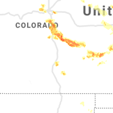
Colorado
| Local Time | Report Details |
|---|---|
| 2:10 PM MDT | Quarter sized hail reported near Littleton, CO, 20.4 miles SSW of Denver, CO |
| 2:51 PM MDT | Half Dollar sized hail reported near Castle Rock, CO, 27.3 miles SSE of Denver, CO |
| 3:28 PM MDT | Asos station kril garfield county rgnl a in garfield county CO, 54.9 miles NE of Grand Junction, CO |
| 3:51 PM MDT | Quarter sized hail reported near Monument, CO, 45.5 miles S of Denver, CO |
| 4:09 PM MDT | Quarter sized hail reported near Colorado Springs, CO, 48.6 miles SSE of Denver, CO |
| 4:13 PM MDT | Tennis Ball sized hail reported near Colorado Springs, CO, 51.5 miles SSE of Denver, CO |
| 4:15 PM MDT | Golf Ball sized hail reported near Colorado Springs, CO, 50.6 miles S of Denver, CO |
| 4:18 PM MDT | Golf Ball sized hail reported near Colorado Springs, CO, 51.6 miles N of Pueblo, CO |
| 4:33 PM MDT | Quarter sized hail reported near Colorado Springs, CO, 49.9 miles N of Pueblo, CO |
| 4:34 PM MDT | Quarter sized hail reported near Colorado Springs, CO, 48.4 miles N of Pueblo, CO |
| 4:36 PM MDT | Ping Pong Ball sized hail reported near Colorado Springs, CO, 48.9 miles N of Pueblo, CO, report from mping: ping pong ball (1.50 in.). |
| 4:37 PM MDT | Storm damage reported in eagle county CO, 69.1 miles SSE of Craig, CO |
| 4:37 PM MDT | Ping Pong Ball sized hail reported near Colorado Springs, CO, 49.1 miles N of Pueblo, CO |
| 4:44 PM MDT | Quarter sized hail reported near Colorado Springs, CO, 51.1 miles N of Pueblo, CO |
| 4:49 PM MDT | Awos station kege eagle county rgnl airpor in eagle county CO, 69.5 miles SSE of Craig, CO |
| 4:52 PM MDT | Quarter sized hail reported near Peyton, CO, 48 miles N of Pueblo, CO |
| 4:53 PM MDT | Quarter sized hail reported near Peyton, CO, 48 miles N of Pueblo, CO |
| 5:04 PM MDT | Quarter sized hail reported near Peyton, CO, 50.3 miles N of Pueblo, CO |
| 5:12 PM MDT | Golf Ball sized hail reported near Peyton, CO, 43.5 miles N of Pueblo, CO |
| 5:28 PM MDT | Quarter sized hail reported near Colorado Springs, CO, 42 miles N of Pueblo, CO, report from mping: quarter (1.00 in.). |
| 6:00 PM MDT | Hen Egg sized hail reported near Peetz, CO, 61.5 miles NNW of Yuma, CO |
| 6:02 PM MDT | Golf Ball sized hail reported near Fleming, CO, 39.2 miles N of Yuma, CO |
| 6:05 PM MDT | Hen Egg sized hail reported near Fleming, CO, 39.8 miles N of Yuma, CO |
| 6:17 PM MDT | Golf Ball sized hail reported near Peetz, CO, 64 miles NNW of Yuma, CO |
| 6:19 PM MDT | Half Dollar sized hail reported near Yoder, CO, 38.1 miles NE of Pueblo, CO |
| 6:25 PM MDT | Baseball sized hail reported near Crook, CO, 50.6 miles N of Yuma, CO, car window broken. |
| 6:44 PM MDT | Mesonet station co119 050w054 mesa county line sout in delta county CO, 20.7 miles SE of Grand Junction, CO |
| 6:55 PM MDT | Baseball sized hail reported near Sedgwick, CO, 56.9 miles N of Yuma, CO, baseball hail with 50 mph winds knocking out car windows. |
| 7:45 PM MDT | Quarter sized hail reported near Wray, CO, 33.9 miles ESE of Yuma, CO, caller reported hail from pea to quarter sized. time estimated by radar. |
| 7:50 PM MDT | Golf Ball sized hail reported near Wray, CO, 33.9 miles ESE of Yuma, CO, caller reported hail from pea to golf ball. time estimated by radar and caller. |
| 8:15 PM MDT | Quarter sized hail reported near Lamar, CO, 94.9 miles W of Garden City, KS |
Wisconsin
| Local Time | Report Details |
|---|---|
| 3:18 PM CDT | Emergency manager reports trees and power lines down near glen have in grant county WI, 66.8 miles NNE of Cedar Rapids, IA |
| 3:20 PM CDT | Emergency manager reports trees and power lines down near bloomingto in grant county WI, 65.7 miles SSE of La Crosse, WI |
| 3:55 PM CDT | Damage to shed... some tree limbs down. time estimated from rada in grant county WI, 56.4 miles WSW of Madison, WI |
Wyoming
| Local Time | Report Details |
|---|---|
| 3:28 PM MDT | Half Dollar sized hail reported near Cheyenne, WY, 25.7 miles E of Laramie, WY |
| 3:48 PM MDT | Half Dollar sized hail reported near Cheyenne, WY, 41.8 miles ESE of Laramie, WY |
| 3:50 PM MDT | Quarter sized hail reported near Cheyenne, WY, 45.9 miles E of Laramie, WY, crest ridge subdivision. |
| 3:50 PM MDT | Half Dollar sized hail reported near Cheyenne, WY, 43.3 miles ESE of Laramie, WY |
| 3:53 PM MDT | Quarter sized hail reported near Cheyenne, WY, 44.7 miles ESE of Laramie, WY |
| 4:03 PM MDT | Quarter sized hail reported near Cheyenne, WY, 42.8 miles ESE of Laramie, WY, near anderson elementary school. |
| 4:08 PM MDT | Half Dollar sized hail reported near Cheyenne, WY, 43.8 miles ESE of Laramie, WY |
| 4:14 PM MDT | Quarter sized hail reported near Cheyenne, WY, 40.1 miles ESE of Laramie, WY, via twitter. |
| 4:45 PM MDT | Half Dollar sized hail reported near Carpenter, WY, 63.2 miles SW of Scottsbluff, NE |
| 4:45 PM MDT | Quarter sized hail reported near Carpenter, WY, 65.8 miles ESE of Laramie, WY |
| 4:56 PM MDT | Half Dollar sized hail reported near Carpenter, WY, 67.3 miles SSW of Scottsbluff, NE |
Alabama
| Local Time | Report Details |
|---|---|
| 4:58 PM CDT | Reports of trees and power lines down on highway 31. reports via social medi in escambia county AL, 54.2 miles SSE of Camden, AL |
Maine
| Local Time | Report Details |
|---|---|
| 6:05 PM EDT | Quarter sized hail reported near Presque Isle, ME, 11.7 miles S of Caribou, ME |
Ohio
| Local Time | Report Details |
|---|---|
| 6:11 PM EDT | Manhole cover blown of in knox county OH, 40.1 miles NE of Columbus, OH |
| 6:13 PM EDT | Multiple trees dow in knox county OH, 39.5 miles NE of Columbus, OH |
| 6:14 PM EDT | Multiple trees dow in knox county OH, 39.5 miles NE of Columbus, OH |
| 6:29 PM EDT | Tree down across roa in knox county OH, 42.1 miles NE of Columbus, OH |
| 11:30 PM EDT | One tree downe in williams county OH, 43.7 miles NE of Fort Wayne, IN |
| 11:45 PM EDT | Power lines down. time estimated from rada in fulton county OH, 55.6 miles NE of Fort Wayne, IN |
| 11:59 PM EDT | Power lines dow in fulton county OH, 66.1 miles ENE of Fort Wayne, IN |
| 12:03 AM EDT | Tree fell on powerlines. time estimated by rada in lucas county OH, 82.6 miles ENE of Fort Wayne, IN |
| 12:14 AM EDT | Asos station ktol toled in lucas county OH, 76 miles ENE of Fort Wayne, IN |
| 12:21 AM EDT | Multiple trees down. time estimated via rada in lucas county OH, 81.3 miles ENE of Fort Wayne, IN |
| 1:00 AM EDT | Tree fell on porch. time estimated via rada in lucas county OH, 82.7 miles ENE of Fort Wayne, IN |
Texas
| Local Time | Report Details |
|---|---|
| 5:24 PM CDT | Storm damage reported in culberson county TX, 98.8 miles E of El Paso, TX |
Utah
| Local Time | Report Details |
|---|---|
| 4:34 PM MDT | Storm damage reported in grand county UT, 66.9 miles WSW of Grand Junction, CO |
New Mexico
| Local Time | Report Details |
|---|---|
| 5:10 PM MDT | Elev 4050 ft wsmr in otero county NM, 92.1 miles N of El Paso, TX |
| 5:12 PM MDT | Elev 4094 ft awos in otero county NM, 78.5 miles NNE of El Paso, TX |
| 5:45 PM MDT | Elev 4085 ft wsmr in sierra county NM, 102.3 miles N of El Paso, TX |
| 6:03 PM MDT | Ktcc asos. related to thunderstorm outflo in quay county NM, 6.9 miles ENE of Tucumcari, NM |
Michigan
| Local Time | Report Details |
|---|---|
| 9:03 PM EDT | Many large trees down near paw paw lake. many roads impassabl in berrien county MI, 61.6 miles SSW of Grand Rapids, MI |
| 9:03 PM EDT | Storm damage reported in berrien county MI, 64.2 miles ENE of Chicago, IL |
| 9:29 PM EDT | Numerous power outage in van buren county MI, 55.2 miles SSW of Grand Rapids, MI |
| 9:43 PM EDT | Numerous large branches dow in berrien county MI, 71.8 miles E of Chicago, IL |
| 9:45 PM EDT | Storm damage reported in berrien county MI, 67.9 miles E of Chicago, IL |
| 9:58 PM EDT | 6 inch trees dow in kalamazoo county MI, 53.6 miles S of Grand Rapids, MI |
| 10:15 PM EDT | 60 foot guyed amateur radio tower blown dow in van buren county MI, 52.7 miles SSW of Grand Rapids, MI |
| 10:40 PM EDT | Several trees and limbs down from coldwater to quinc in branch county MI, 60.2 miles N of Fort Wayne, IN |
| 11:50 PM EDT | M-dot reports tree down on nb us-23 at cone rd blocking all lane in monroe county MI, 67.7 miles S of Flint, MI |
Indiana
| Local Time | Report Details |
|---|---|
| 8:13 PM CDT | Measured wind gust to 58 mph at the gary airpor in lake county IN, 21.5 miles SSE of Chicago, IL |
| 8:45 PM CDT | Numerous large branches and powerlines down across the count in la porte county IN, 50.8 miles ESE of Chicago, IL |
| 8:47 PM CDT | Estimated wind gust to 65 mph near 129th and delaware street in lake county IN, 38.2 miles SSE of Chicago, IL |
| 9:00 PM CDT | Storm damage reported in porter county IN, 34.8 miles SE of Chicago, IL |
| 10:00 PM EDT | Tree downe in st. joseph county IN, 65.5 miles NW of Fort Wayne, IN |
| 10:03 PM EDT | Tree downe in st. joseph county IN, 70 miles ESE of Chicago, IL |
| 10:10 PM EDT | Tree downe in elkhart county IN, 57.8 miles NW of Fort Wayne, IN |
| 9:25 PM CDT | Several trees and powerlines dow in starke county IN, 66.2 miles SE of Chicago, IL |
| 10:35 PM EDT | Tree uproote in elkhart county IN, 45.6 miles NW of Fort Wayne, IN |
| 10:38 PM EDT | Tree and shingle damag in marshall county IN, 64.9 miles WNW of Fort Wayne, IN |
| 11:04 PM EDT | Large limbs blocking roa in noble county IN, 28.7 miles NNW of Fort Wayne, IN |
| 11:04 PM EDT | Multiple trees and power lines dow in steuben county IN, 33.8 miles N of Fort Wayne, IN |
| 11:07 PM EDT | Tree down and power is ou in steuben county IN, 42.4 miles N of Fort Wayne, IN |
| 11:11 PM EDT | Tree down onto hous in whitley county IN, 30.3 miles WNW of Fort Wayne, IN |
| 11:45 PM EDT | Tree limbs and power lines down. mpin in allen county IN, 7.1 miles NE of Fort Wayne, IN |
| 12:15 AM CDT | Reports of powerlines and trees down near newton street and wayland avenue relayed by newton county so. time estimated based on radar and call log tim in newton county IN, 78.8 miles SSE of Chicago, IL |
Kansas
| Local Time | Report Details |
|---|---|
| 8:38 PM CDT | Quarter sized hail reported near Belleville, KS, 74.9 miles NW of Manhattan, KS |
| 9:32 PM CDT | Quarter sized hail reported near Belleville, KS, 72.6 miles NW of Manhattan, KS |
| 9:06 PM MDT | Storm damage reported in sherman county KS, 34.6 miles W of Colby, KS |
| 10:15 PM CDT | Tree down on s. grant street... multiple limbs down around tow in cloud county KS, 53.1 miles WNW of Manhattan, KS |
| 10:20 PM CDT | 3 to 4 inch diameter limbs dow in cloud county KS, 55.6 miles WNW of Manhattan, KS |
| 10:33 PM CDT | Corrects previous tstm wnd gst report from 3 wsw clyde. wind gust blew police vehicle off the roa in cloud county KS, 54.2 miles WNW of Manhattan, KS |
| 9:40 PM MDT | Mesonet station k5wlc us-40 - 2 mi. w of wallac in wallace county KS, 47 miles SW of Colby, KS |
| 11:13 PM CDT | Quarter sized hail reported near Phillipsburg, KS, 60.3 miles N of Hays, KS |
| 11:25 PM CDT | Near 18th and buffalo roa in clay county KS, 44.5 miles WNW of Manhattan, KS |
| 11:26 PM CDT | Half Dollar sized hail reported near Aurora, KS, 54.6 miles WNW of Manhattan, KS |
| 11:50 PM CDT | Golf Ball sized hail reported near Miltonvale, KS, 49.1 miles WNW of Manhattan, KS |
| 12:44 AM CDT | Severe outflow winds in lincoln county KS, 72.9 miles ENE of Hays, KS |
| 12:45 AM CDT | Mesonet station as692 scott cit in scott county KS, 34.6 miles N of Garden City, KS |
| 12:49 AM CDT | Report was from the kansas mesonet station lnuk in lane county KS, 48.7 miles NNE of Garden City, KS |
| 12:50 AM CDT | Asos station kgck garden cit in finney county KS, 9 miles ESE of Garden City, KS |
| 1:20 AM CDT | Report was from social medi in lane county KS, 41.5 miles NNE of Garden City, KS |
| 1:36 AM CDT | Khlc asos reported wind gust of 64 mp in graham county KS, 43.6 miles NW of Hays, KS |
| 1:40 AM CDT | Mesonet station up852 3.7 w ogallah (upr in trego county KS, 26.7 miles WNW of Hays, KS |
| 2:03 AM CDT | Storm damage reported in rooks county KS, 35.2 miles N of Hays, KS |
| 2:06 AM CDT | Davis weatherlink statio in rooks county KS, 24.8 miles N of Hays, KS |
| 2:14 AM CDT | Pws station kksnatom in rooks county KS, 32.4 miles NNE of Hays, KS |
| 2:15 AM CDT | Davis weatherlink statio in rooks county KS, 38.7 miles N of Hays, KS |
| 2:16 AM CDT | Pws station kksnatom in rooks county KS, 32.4 miles NNE of Hays, KS |
| 2:30 AM CDT | Storm damage reported in russell county KS, 27.8 miles ESE of Hays, KS |
| 2:32 AM CDT | Em reports 61 mph gust measured in tonganoxie and power out in tow in leavenworth county KS, 26.7 miles W of Kansas City, MO |
| 3:02 AM CDT | Nws employee reports patio table flippe in wyandotte county KS, 13.4 miles W of Kansas City, MO |
| 3:57 AM CDT | This report was from the kansas mesonet station hays (hask1 in ellis county KS, 1.5 miles SSW of Hays, KS |
| 4:12 AM CDT | Awos station khys hays regional airport awos sit in ellis county KS, 3.7 miles ESE of Hays, KS |
Nebraska
| Local Time | Report Details |
|---|---|
| 8:00 PM MDT | Quarter sized hail reported near Hyannis, NE, 67.2 miles NW of North Platte, NE, some quarter size hail... heavy rain |
| 8:00 PM MDT | Quarter sized hail reported near Lewellen, NE, 75.6 miles WNW of North Platte, NE, quarters to peas blanketing ground and roofs. heavy rain. |
| 8:00 PM MDT | Ping Pong Ball sized hail reported near Oshkosh, NE, 76.7 miles WNW of North Platte, NE, ping pong hail... heavy rain |
| 8:40 PM MDT | Quarter sized hail reported near Hyannis, NE, 67.2 miles NW of North Platte, NE, some quarter size hail... heavy rain |
| 8:47 PM MDT | Quarter sized hail reported near Arthur, NE, 63 miles WNW of North Platte, NE, quarter size hail |
| 9:30 PM MDT | Quarter sized hail reported near Imperial, NE, 56.5 miles SW of North Platte, NE, quarter size hail and heavy rain |
| 11:16 PM CDT | Estimated 60-70 mph winds with heavy rainfal in hayes county NE, 37.2 miles SW of North Platte, NE |
| 11:41 PM CDT | Half Dollar sized hail reported near Tecumseh, NE, 62.1 miles SSW of Omaha, NE |
| 11:41 PM CDT | Storm damage reported in johnson county NE, 62.1 miles SSW of Omaha, NE |
| 12:45 AM CDT | Half Dollar sized hail reported near Franklin, NE, 65.3 miles SSW of Grand Island, NE, time estimated from radar. |
Missouri
| Local Time | Report Details |
|---|---|
| 11:54 PM CDT | Twitter report of power pole blown down near lake marie... southwest of merce in mercer county MO, 76 miles S of Des Moines, IA |
| 1:20 AM CDT | St. joseph airport asos reported 68 mph gus in buchanan county MO, 49.2 miles NNW of Kansas City, MO |
| 1:20 AM CDT | Modot observation station at us 36 and 10th street in st. joseph reported gust of 80 mph at 1:20 a in buchanan county MO, 46.9 miles NNW of Kansas City, MO |
Connect with Interactive Hail Maps