

Hail Map for Saturday, June 27, 2020

Number of Impacted Households on 6/27/2020
0
Impacted by 1" or Larger Hail
0
Impacted by 1.75" or Larger Hail
0
Impacted by 2.5" or Larger Hail
Square Miles of Populated Area Impacted on 6/27/2020
0
Impacted by 1" or Larger Hail
0
Impacted by 1.75" or Larger Hail
0
Impacted by 2.5" or Larger Hail


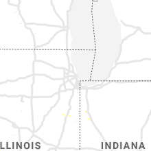


Cities Most Affected by Hail Storms of 6/27/2020
| Hail Size | Demographics of Zip Codes Affected | ||||||
|---|---|---|---|---|---|---|---|
| City | Count | Average | Largest | Pop Density | House Value | Income | Age |
| Glenvil, NE | 1 | 1.75 | 1.75 | 8 | $52k | $37.1k | 41.4 |
Hail and Wind Damage Spotted on 6/27/2020
Filter by Report Type:Hail ReportsWind Reports
States Impacted
Georgia, Pennsylvania, Florida, New Jersey, Maryland, Montana, Virginia, District of Columbia, Arizona, Illinois, New York, Missouri, New Mexico, South Carolina, Colorado, North Dakota, Nevada, South Dakota, Idaho, Kansas, Wyoming, Tennessee, Utah, NebraskaGeorgia
| Local Time | Report Details |
|---|---|
| 2:18 PM EDT | Emergency manager reports a barn and out house destroyed at a residence off webber r in gordon county GA, 45.1 miles SSE of Chattanooga, TN |
| 3:50 PM EDT | A large tree was downed in the river green subdivisio in cherokee county GA, 33.5 miles NNW of Atlanta, GA |
| 4:10 PM EDT | 911 call center reported tree down. time estimated by rada in elbert county GA, 50.9 miles SSW of Greenville, SC |
| 4:15 PM EDT | 911 call center reported tree down. time estimated by rada in elbert county GA, 52.5 miles SSW of Greenville, SC |
| 4:20 PM EDT | Large tree downed near the intersection of linda lane sw and dorsey circle sw... taking out neighborhood powe in gwinnett county GA, 18.5 miles ENE of Atlanta, GA |
| 4:20 PM EDT | 911 call center reported down tree. time estimated by rada in elbert county GA, 54.2 miles SSW of Greenville, SC |
| 4:35 PM EDT | Several small trees were snapped in half... and lots of branches were strewn over the road at sunset dr. and longview d in gwinnett county GA, 17 miles NE of Atlanta, GA |
| 4:45 PM EDT | Tree downed at the intersection of river drive sw and vinyard wa in gwinnett county GA, 20.4 miles ENE of Atlanta, GA |
| 4:48 PM EDT | A tree was downed on maple stree in gwinnett county GA, 23 miles ENE of Atlanta, GA |
| 4:56 PM EDT | A tree was downed onto a home near the intersection of hwy 124 and hwy 33 in jackson county GA, 46.9 miles ENE of Atlanta, GA |
| 5:00 PM EDT | Measured by home anemometer on mountain creek church r in jackson county GA, 48.7 miles NE of Atlanta, GA |
| 5:03 PM EDT | A tree was downed on lee peters rd at etchison r in walton county GA, 33.3 miles E of Atlanta, GA |
| 5:03 PM EDT | A tree was downed on buck smith roa in walton county GA, 30.1 miles E of Atlanta, GA |
| 5:08 PM EDT | A tree was downed on jack glass roa in walton county GA, 42.9 miles ENE of Atlanta, GA |
| 5:18 PM EDT | A tree was downed on jacks creek rd at mount carmel church r in walton county GA, 46.3 miles E of Atlanta, GA |
| 5:25 PM EDT | A tree was downed on queens cemetery roa in walton county GA, 43.8 miles E of Atlanta, GA |
| 5:27 PM EDT | A tree was downed on highway 186 at jones woods roa in walton county GA, 49.7 miles E of Atlanta, GA |
| 5:30 PM EDT | A tree was downed at malcolm rd and hester town r in walton county GA, 45.6 miles E of Atlanta, GA |
| 5:30 PM EDT | A tree was downed on browning shoals roa in walton county GA, 44 miles E of Atlanta, GA |
| 5:31 PM EDT | A tree was downed on sweetbriar road near knox chapel roa in walton county GA, 43 miles E of Atlanta, GA |
| 6:05 PM EDT | Quarter sized hail reported near Eastman, GA, 51.6 miles NNW of Douglas, GA, social media photo of quarter-sized hail at the intersection of 9th ave and pine drive. |
| 6:10 PM EDT | 911 call center reported tree down. time estimated by rada in elbert county GA, 50.9 miles SSW of Greenville, SC |
| 6:15 PM EDT | 911 call center reported tree down. time estimated by rada in elbert county GA, 52.5 miles SSW of Greenville, SC |
| 6:20 PM EDT | 911 call center reported down tree. time estimated by rada in elbert county GA, 54.2 miles SSW of Greenville, SC |
| 6:20 PM EDT | Several tree limbs the size of small trees were downed across elizabeth driv in wilkes county GA, 47.1 miles WNW of Augusta, GA |
| 6:20 PM EDT | 911 call center reported tree down. time estimated by rada in elbert county GA, 57.7 miles NW of Augusta, GA |
| 6:20 PM EDT | 911 call center reported tree down. time estimated by rada in elbert county GA, 54.1 miles SSW of Greenville, SC |
| 7:21 PM EDT | Report of trees down or snappe in columbia county GA, 9 miles W of Augusta, GA |
| 9:06 PM EDT | Two medium sized trees down with a measured 60 mph wind gust... 2 miles east of madray spring in wayne county GA, 54.9 miles WSW of Savannah, GA |
Pennsylvania
| Local Time | Report Details |
|---|---|
| 3:16 PM EDT | 1.56 inches of rai in northampton county PA, 54.6 miles SSE of Scranton, PA |
| 3:18 PM EDT | Downed trees and wires near salisbury road. time estimated from rada in lehigh county PA, 58 miles SSE of Scranton, PA |
| 3:22 PM EDT | Downed trees and wires near kurtz street. time estimated from rada in lehigh county PA, 55.8 miles S of Scranton, PA |
| 3:22 PM EDT | Downed trees and power lines near congress street. time estimated from rada in lehigh county PA, 56.3 miles S of Scranton, PA |
| 3:25 PM EDT | Tree down on reading road. time estimated from rada in lehigh county PA, 56.8 miles S of Scranton, PA |
| 3:25 PM EDT | Tree down near 12th and linden streets in allentown. time estimated from rada in lehigh county PA, 56.7 miles S of Scranton, PA |
| 3:27 PM EDT | Corrects previous tstm wnd dmg report from allentown. tree down on hamilton blvd in allentown. time estimated from rada in lehigh county PA, 56.8 miles S of Scranton, PA |
| 3:27 PM EDT | Corrects time of previous tstm wnd dmg report from 4 w allentown. tree down on amherst roa in lehigh county PA, 55.6 miles S of Scranton, PA |
| 3:27 PM EDT | Downed trees and power lines near woodfern drive. time estimated from rada in lehigh county PA, 60.9 miles S of Scranton, PA |
| 3:29 PM EDT | Downed trees and power lines near sour apple lane. time estimated from rada in lehigh county PA, 59.2 miles SSE of Scranton, PA |
| 3:50 PM EDT | Tree down on hamilton blvd in allentown. time estimated from rada in lehigh county PA, 56.8 miles S of Scranton, PA |
| 3:50 PM EDT | Tree down on amherst roa in lehigh county PA, 55.6 miles S of Scranton, PA |
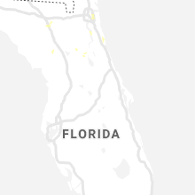
Florida
| Local Time | Report Details |
|---|---|
| 3:45 PM EDT | Large tree uprooted and fell on a structure on county road 240... west of state road 4 in columbia county FL, 67.5 miles WSW of Jacksonville, FL |
| 4:27 PM EDT | Downed power lines near the corner of silo rd and pacetti rd. time of event estimated via rada in st. johns county FL, 27.9 miles SSE of Jacksonville, FL |
| 4:30 PM EDT | Large tree fell on a house near bay st. and highway 22 in baker county FL, 37.1 miles W of Jacksonville, FL |
| 4:30 PM EDT | Large tree snapped near gaskins circle and highway 22 in baker county FL, 37.6 miles W of Jacksonville, FL |
| 4:45 PM EDT | Large tree down near george taber road and u.s. highway 9 in baker county FL, 30.3 miles W of Jacksonville, FL |
| 4:45 PM EDT | Large tree snapped just south of interstate 10 in glen st. mar in baker county FL, 30.5 miles W of Jacksonville, FL |
| 4:50 PM EDT | Tree on power line along woodlawn roa in st. johns county FL, 33.2 miles SSE of Jacksonville, FL |
| 5:20 PM EDT | Fallen trees or limbs resulted in a power outage near the intersection of highway 319 and lawhon mill road. reported via duke energy outage ma in wakulla county FL, 26.1 miles SSW of Tallahassee, FL |
| 5:30 PM EDT | Tree dow in wakulla county FL, 14.8 miles SSW of Tallahassee, FL |
| 5:35 PM EDT | Tree down blocking roa in wakulla county FL, 14 miles S of Tallahassee, FL |
| 5:35 PM EDT | Tree down on power lin in wakulla county FL, 13.1 miles SSW of Tallahassee, FL |
| 5:35 PM EDT | Tree down on power lin in wakulla county FL, 13.1 miles SSW of Tallahassee, FL |
| 5:45 PM EDT | Many trees down across the county as reported from the 911 call cente in wakulla county FL, 12.9 miles SSW of Tallahassee, FL |
| 6:07 PM EDT | Huguenot park mesonet measured wind gust to 69 mph from the southwes in amz452 county FL, 15.9 miles ENE of Jacksonville, FL |
| 6:35 PM EDT | Reports of downed trees all over the county... but power pole down blocking the road at west lake road and lake road in jefferson count in jefferson county FL, 25.9 miles ENE of Tallahassee, FL |
| 7:18 PM EDT | Tree blocking northbound lane 1/4 mile south of the fl/ga state line on highway 1 in jefferson county FL, 28.3 miles ENE of Tallahassee, FL |
New Jersey
| Local Time | Report Details |
|---|---|
| 3:54 PM EDT | Trees down near wertsville. time estimated from rada in hunterdon county NJ, 44.5 miles WSW of Brooklyn, NY |
| 4:04 PM EDT | Tree and wires down over hollow roa in somerset county NJ, 42.8 miles WSW of Brooklyn, NY |
| 4:14 PM EDT | Downed tree closing nj route 27 in both directions just north of route 618. time estimated from rada in somerset county NJ, 37.5 miles WSW of Brooklyn, NY |
| 4:17 PM EDT | Trees and wires down in south brunswick. time estimated from rada in middlesex county NJ, 35.3 miles SW of Brooklyn, NY |
| 4:25 PM EDT | Trees and wires down near route 33 in applegarth. time estimated by rada in middlesex county NJ, 37.5 miles SW of Brooklyn, NY |
| 4:28 PM EDT | Downed tree and wires near john wall road. time estimated from rada in middlesex county NJ, 31.2 miles SW of Brooklyn, NY |
| 4:30 PM EDT | Wires down on lamb lane in manalapan... nj. time estimated from rada in monmouth county NJ, 37.4 miles SSW of Brooklyn, NY |
| 4:36 PM EDT | Downed trees and power lines in vicinity of woodward road near state highway 33. time estimated from rada in monmouth county NJ, 36.5 miles SSW of Brooklyn, NY |
| 4:42 PM EDT | Trees and wires down in the west freehold area. time estimated from rada in monmouth county NJ, 34.6 miles SSW of Brooklyn, NY |
| 4:49 PM EDT | Wires down on fairfield road near route 33. time estimated from rada in monmouth county NJ, 34.1 miles SSW of Brooklyn, NY |
| 4:56 PM EDT | Downed trees and power lines near shrewsbury avenue and bank street. time estimated from rada in monmouth county NJ, 24.8 miles S of Brooklyn, NY |
| 5:01 PM EDT | Wires down in manasquan. time estimated from rada in monmouth county NJ, 38.9 miles S of Brooklyn, NY |
| 5:01 PM EDT | Corrects previous tstm wnd dmg report from brick. tree down in brick... reported on social media with picture. time estimated from rada in ocean county NJ, 47.8 miles S of Brooklyn, NY |
| 6:40 PM EDT | Gust of 59 mph measured at new jersey net station 6 in cumberland county NJ, 63.3 miles N of Ocean City, MD |
Maryland
| Local Time | Report Details |
|---|---|
| 4:42 PM EDT | Multiple trees down throughout bethesda... m in montgomery county MD, 34.4 miles WSW of Baltimore, MD |
| 4:42 PM EDT | Numerous trees and branches down in the chevy chase and bethesda area. a tree fell on a house on jones bridge road. several trees were down along i-495 capital beltway in montgomery county MD, 32.3 miles SW of Baltimore, MD |
| 4:46 PM EDT | Ramp from i-495 inner loop to sb md-355 blocked by downed tree in montgomery county MD, 32.3 miles SW of Baltimore, MD |
| 4:51 PM EDT | Ct ave near i-495 and jones bridge rd blocked by downed tree in montgomery county MD, 32.3 miles SW of Baltimore, MD |
| 5:05 PM EDT | Trees down in betterton. time estimated from rada in kent county MD, 30 miles E of Baltimore, MD |
| 5:05 PM EDT | Debris on md route 292 at howell point road. time estimated from rada in kent county MD, 29.3 miles E of Baltimore, MD |
| 5:10 PM EDT | Downed tree at the intersection of defense hwy and rutland r in anne arundel county MD, 22.9 miles SSE of Baltimore, MD |
| 5:16 PM EDT | Downed tree on wires at the intersection of md-450 defense highway and rutland roa in anne arundel county MD, 20.7 miles S of Baltimore, MD |
| 5:26 PM EDT | Several trees down in the area of md-450 governor ritchie highway and md-648 baltimore annapolis boulevar in anne arundel county MD, 21.2 miles SSE of Baltimore, MD |
| 5:38 PM EDT | Debris on md 446 south at whispering pines lane. time estimated from rada in kent county MD, 27 miles ESE of Baltimore, MD |
| 5:43 PM EDT | Debris on md 446 south at whispering pines lane. time estimated from radar. this corrects the time of the event contained in the previous repor in kent county MD, 27 miles ESE of Baltimore, MD |
| 5:48 PM EDT | Several reports of trees and power lines down along broad neck road and near island point. time based on utility company report in kent county MD, 26.3 miles ESE of Baltimore, MD |
Montana
| Local Time | Report Details |
|---|---|
| 2:43 PM MDT | A 55 kt (63 mph) thunderstorm wind gust was reporte in hill county MT, 0.2 miles SSE of Havre, MT |
| 2:44 PM MDT | Saddle butte havre station reported a thunderstorm wind gust of 50 kt (58 mph in hill county MT, 3.3 miles SSE of Havre, MT |
| 2:46 PM MDT | Quarter sized hail reported near Havre, MT, 0.2 miles SSE of Havre, MT, corrects remarks on previous hail report from 1 ene havre. heavy rain and hail of at least one inch diameter. call from spotter at time hail observed. video posted to s |
| 8:03 PM MDT | Some fences were blown away by strong winds. saco us-2 station reported a wind gust of 55 mph. report of damages from social medi in phillips county MT, 40 miles WNW of Glasgow, MT |
| 8:35 PM MDT | Storm damage reported in rosebud county MT, 41.4 miles W of Miles City, MT |
Virginia
| Local Time | Report Details |
|---|---|
| 4:43 PM EDT | A large tree was down along gibson oaks driv in fairfax county VA, 49.1 miles WSW of Baltimore, MD |
| 4:45 PM EDT | Multiple trees down between herndon and chantilly (near oak grove)... including a large tree along gibson oaks driv in fairfax county VA, 49.1 miles WSW of Baltimore, MD |
District of Columbia
| Local Time | Report Details |
|---|---|
| 5:05 PM EDT | 7 downed trees reported throughout d in district of columb county DC, 31.1 miles SW of Baltimore, MD |
Arizona
| Local Time | Report Details |
|---|---|
| 2:41 PM MST | Asos station ksad safford regional airpor in graham county AZ, 79 miles W of Silver City, NM |
| 5:07 PM MST | Asos station ksad safford regional airpor in graham county AZ, 79 miles W of Silver City, NM |
Illinois
| Local Time | Report Details |
|---|---|
| 4:49 PM CDT | Trees downed and split in hal in iroquois county IL, 66.8 miles SSW of Chicago, IL |
New York
| Local Time | Report Details |
|---|---|
| 6:05 PM EDT | Several trees and power lines down on the north and east side of gouverneu in st. lawrence county NY, 23.8 miles S of Ogdensburg, NY |
| 6:37 PM EDT | Tree branches down between fine and oswegatchie in st. lawrence county NY, 38.2 miles SSE of Ogdensburg, NY |
Missouri
| Local Time | Report Details |
|---|---|
| 6:15 PM CDT | Shingles off home and leaves stuck to house. reported at county road 7360 near newburg. time and location approximat in phelps county MO, 25.8 miles NW of Salem, MO |
New Mexico
| Local Time | Report Details |
|---|---|
| 5:22 PM MDT | Kcvn awo in curry county NM, 63.6 miles SE of Tucumcari, NM |
South Carolina
| Local Time | Report Details |
|---|---|
| 7:31 PM EDT | Tree in roadway at ivy link road and turtle trail. time estimated from rada in lexington county SC, 51.4 miles NE of Augusta, GA |
| 7:47 PM EDT | Trees down at chadford road and north royal tower roa in richland county SC, 61.8 miles NE of Augusta, GA |
| 7:48 PM EDT | Tree in roadway at old dibble road and woodward driv in aiken county SC, 19.7 miles E of Augusta, GA |
| 7:49 PM EDT | Tree in roadway at croft mill road and university parkwa in aiken county SC, 14.2 miles ENE of Augusta, GA |
| 7:52 PM EDT | Trees in roadway at broad river and zimalcrest driv in richland county SC, 63.9 miles NE of Augusta, GA |
| 7:57 PM EDT | Tree in roadway at cedar grove road and windmill roa in lexington county SC, 45.9 miles NE of Augusta, GA |
| 7:58 PM EDT | Trees down at atomic road and silver bluff roa in aiken county SC, 10.8 miles SE of Augusta, GA |
| 7:58 PM EDT | Tree in roadway at storm branch road and branch court. time estimated from rada in aiken county SC, 6.8 miles E of Augusta, GA |
| 7:58 PM EDT | Tree in roadway at sheraton drive and old jackson highway. time estimated from rada in aiken county SC, 6.4 miles SE of Augusta, GA |
| 8:00 PM EDT | Tree in roadway at robinwood road and lake shore drive. time estimated from radar. corrected for tim in richland county SC, 70.6 miles ENE of Augusta, GA |
| 8:00 PM EDT | Savannah river site eoc reported tree down near b area. time estimate in aiken county SC, 19.7 miles SE of Augusta, GA |
| 8:02 PM EDT | Tree in roadway at atomic road and pine log road. time estimated from rada in aiken county SC, 9.9 miles SE of Augusta, GA |
| 8:05 PM EDT | Savannah river site eoc reported tree down near c area. time estimate in barnwell county SC, 23.7 miles SE of Augusta, GA |
| 8:10 PM EDT | Tree in roadway at old mcgraw road and us-601. time estimated from rada in richland county SC, 69.8 miles NW of Charleston, SC |
| 8:10 PM EDT | Tree in roadway at 517 whaley street. corrected for time... estimated from rada in richland county SC, 64 miles ENE of Augusta, GA |
| 8:11 PM EDT | Tree on house on windsor lake blvd. no reports of injuries at this time. corrected for time... estimated from rada in richland county SC, 73 miles NE of Augusta, GA |
| 8:11 PM EDT | Tree on power lines on bridgewood roa in richland county SC, 70.1 miles NE of Augusta, GA |
| 8:12 PM EDT | Tree in roadway at springfield road and gleaton circl in orangeburg county SC, 40.8 miles E of Augusta, GA |
| 8:14 PM EDT | Tree on house on beaumont ave. no reports of injuries at this time. corrected for time... estimated from rada in richland county SC, 66.8 miles NE of Augusta, GA |
| 8:15 PM EDT | Tree on power lines on garners ferry road at garners crossing apartment in richland county SC, 68.2 miles ENE of Augusta, GA |
| 8:16 PM EDT | Tree in roadway at robinwood road and lake shore drive. time estimated from rada in richland county SC, 70.6 miles ENE of Augusta, GA |
| 8:16 PM EDT | Tree in roadway on asia fulmer cour in orangeburg county SC, 39.7 miles E of Augusta, GA |
| 8:16 PM EDT | Tree in roadway at pig pen landing road and capital wa in orangeburg county SC, 40.2 miles E of Augusta, GA |
| 8:18 PM EDT | Tree in roadway at 517 whaley stree in richland county SC, 64 miles ENE of Augusta, GA |
| 8:20 PM EDT | Tree in roadway at boggy gut road and us-278. time estimated from rada in aiken county SC, 22.2 miles ESE of Augusta, GA |
| 8:20 PM EDT | Tree in roadway at the intersection of willow swamp and herbert road in orangeburg county SC, 44.8 miles E of Augusta, GA |
| 8:22 PM EDT | Tree in roadway at wire road and sc-33 in orangeburg county SC, 47.1 miles E of Augusta, GA |
| 8:25 PM EDT | Tree in roadway at bonnette road and sc-33 in orangeburg county SC, 50.1 miles E of Augusta, GA |
| 8:29 PM EDT | Tree on house on windsor lake blvd. no reports of injuries at this tim in richland county SC, 73 miles NE of Augusta, GA |
| 8:36 PM EDT | Tree on house on beaumont ave. no reports of injuries at this tim in richland county SC, 66.8 miles NE of Augusta, GA |
| 8:40 PM EDT | Orangeburg co em reported a tree fell onto a house on squire dr in cordova. no reports of injuries at this time. extent of damage to the home unknown at this time. time in orangeburg county SC, 54 miles WNW of Charleston, SC |
| 8:49 PM EDT | Tree in roadway at binnicker bridge road and hickory hill roa in orangeburg county SC, 57 miles WNW of Charleston, SC |
| 8:49 PM EDT | Tree in roadway at zion church road and us-30 in orangeburg county SC, 56.6 miles WNW of Charleston, SC |
| 8:55 PM EDT | Trees down on five chop rd and big buck blvd. time estimate in orangeburg county SC, 44.2 miles WNW of Charleston, SC |
| 8:59 PM EDT | A tree was reported down on whetsell street at twins lane due to thunderstorm outflo in dorchester county SC, 36.9 miles W of Charleston, SC |
| 9:01 PM EDT | Law enforecemnt reported a tree down near the intersection of saint mark bowman road and lemon grove roa in dorchester county SC, 34.9 miles W of Charleston, SC |
| 9:06 PM EDT | A tree was reported down at tabor road and bell's highway due to thunderstorm outflo in colleton county SC, 47.7 miles WSW of Charleston, SC |
| 9:12 PM EDT | Tree in roadway on tee vee roa in orangeburg county SC, 34.9 miles WNW of Charleston, SC |
| 9:20 PM EDT | A tree was reported down on sc-651 and wesley grove road due to thunderstorm outflo in colleton county SC, 31.5 miles WSW of Charleston, SC |
| 9:21 PM EDT | Tree in roadway at goldsmith road and calhoun stree in orangeburg county SC, 49 miles W of Charleston, SC |
| 9:33 PM EDT | Tree in roadway at the intersection of gilway and gum street in orangeburg county SC, 24.5 miles WNW of Charleston, SC |
Colorado
| Local Time | Report Details |
|---|---|
| 6:35 PM MDT | Quarter sized hail reported near Eads, CO, 95.8 miles ENE of Pueblo, CO |
| 7:30 PM MDT | Mesonet station fw2420 arapaho in cheyenne county CO, 75.4 miles WSW of Colby, KS |
| 7:40 PM MDT | Mesonet station up694 2.2 e arapahoe (upr in cheyenne county CO, 69.4 miles WSW of Colby, KS |
| 8:29 PM MDT | Asos station kitr burlington co airport. 43 mph sustaine in kit carson county CO, 65.7 miles SSE of Yuma, CO |
North Dakota
| Local Time | Report Details |
|---|---|
| 7:35 PM CDT | Amends earlier lsr based on additional information from ndawn. new lsr from 10 meter observation. mesonet station 4 s minot (ndawn in ward county ND, 3.9 miles S of Minot, ND |
Nevada
| Local Time | Report Details |
|---|---|
| 5:46 PM PDT | Asos station keko elko airport aso in elko county NV, 1.2 miles SSW of Elko, NV |
South Dakota
| Local Time | Report Details |
|---|---|
| 8:10 PM CDT | Quarter sized hail reported near Winner, SD, 38.6 miles NNE of Valentine, NE |
Idaho
| Local Time | Report Details |
|---|---|
| 7:44 PM MDT | Quarter sized hail reported near Malta, ID, 65.3 miles SE of Twin Falls, ID |
| 9:48 PM MDT | Storm damage reported in bear lake county ID, 86.1 miles SSE of Idaho Falls, ID |
Kansas
| Local Time | Report Details |
|---|---|
| 8:00 PM MDT | Quarter sized hail reported near Goodland, KS, 48 miles W of Colby, KS |
| 8:30 PM MDT | Mesonet station k5ed7 i-70 - edson interchang in sherman county KS, 29 miles W of Colby, KS |
| 9:48 PM CDT | Storm damage reported in thomas county KS, 17.6 miles W of Colby, KS |
| 2:02 AM CDT | Corrects previous tstm wnd gst report from 2 ese oakley. temperature jumped to 81 degree in logan county KS, 23.2 miles SSE of Colby, KS |
| 6:39 AM CDT | Quarter sized hail reported near Rossville, KS, 33.4 miles E of Manhattan, KS |
Wyoming
| Local Time | Report Details |
|---|---|
| 8:15 PM MDT | Awos station kdub dubois airpor in fremont county WY, 74.9 miles WNW of Riverton, WY |
Tennessee
| Local Time | Report Details |
|---|---|
| 9:22 PM CDT | A few trees downed on tn highway 26 in jackson county TN, 62.7 miles ENE of Nashville, TN |
Utah
| Local Time | Report Details |
|---|---|
| 9:40 PM MDT | Gunnison island in box elder county UT, 63.8 miles NW of Salt Lake City, UT |
| 10:15 PM MDT | Promontory point in box elder county UT, 45 miles NW of Salt Lake City, UT |
Nebraska
| Local Time | Report Details |
|---|---|
| 12:45 AM CDT | Ping Pong Ball sized hail reported near Davenport, NE, 50.7 miles SSE of Grand Island, NE, facebook picture relayed by em. time estimated from radar. |
| 12:47 AM CDT | Golf Ball sized hail reported near Glenvil, NE, 34.8 miles S of Grand Island, NE, emergency manager relayed report. |
| 12:55 AM CDT | Quarter sized hail reported near Hastings, NE, 25.3 miles S of Grand Island, NE |
| 12:56 AM CDT | Davis weatherlink statio in kearney county NE, 43.8 miles WSW of Grand Island, NE |
| 12:58 AM CDT | Quarter sized hail reported near Hastings, NE, 22.7 miles S of Grand Island, NE, report and picture on facebook. |
| 1:06 AM CDT | Quarter sized hail reported near Hastings, NE, 19.1 miles S of Grand Island, NE |
| 1:08 AM CDT | Quarter sized hail reported near Hastings, NE, 19.1 miles S of Grand Island, NE |
| 1:50 AM CDT | Report of 5 power poles down on highway 34. power company in rout in hamilton county NE, 13.6 miles ESE of Grand Island, NE |
| 2:20 AM CDT | Storm damage reported in fillmore county NE, 55 miles SE of Grand Island, NE |
| 2:26 AM CDT | Storm damage reported in fillmore county NE, 60 miles SE of Grand Island, NE |
| 2:42 AM CDT | Storm damage reported in saline county NE, 58.4 miles ESE of Grand Island, NE |
| 3:17 AM CDT | Storm damage reported in gage county NE, 61.4 miles SW of Omaha, NE |
| 4:00 AM CDT | Power is out in nebraska city. estimate of 65 mph initial wind gus in otoe county NE, 40.3 miles S of Omaha, NE |
Connect with Interactive Hail Maps