

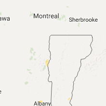
Hail Map for Tuesday, June 27, 2017

Number of Impacted Households on 6/27/2017
0
Impacted by 1" or Larger Hail
0
Impacted by 1.75" or Larger Hail
0
Impacted by 2.5" or Larger Hail
Square Miles of Populated Area Impacted on 6/27/2017
0
Impacted by 1" or Larger Hail
0
Impacted by 1.75" or Larger Hail
0
Impacted by 2.5" or Larger Hail


Cities Most Affected by Hail Storms of 6/27/2017
| Hail Size | Demographics of Zip Codes Affected | ||||||
|---|---|---|---|---|---|---|---|
| City | Count | Average | Largest | Pop Density | House Value | Income | Age |
| Rushville, NE | 1 | 1.75 | 1.75 | 1 | $43k | $28.7k | 42.9 |
| Westport, NY | 1 | 1.75 | 1.75 | 16 | $81k | $39.9k | 49.0 |
| Mandan, ND | 1 | 1.75 | 1.75 | 38 | $83k | $39.5k | 37.6 |
Hail and Wind Damage Spotted on 6/27/2017
Filter by Report Type:Hail ReportsWind Reports
States Impacted
Montana, Kansas, Nebraska, New York, Massachusetts, Wyoming, Pennsylvania, Vermont, New Hampshire, Maine, Connecticut, South Dakota, New Mexico, Rhode Island, North Dakota, Colorado, Minnesota, IowaMontana
| Local Time | Report Details |
|---|---|
| 6:25 AM MDT | Peak wind gust at monida pas in beaverhead county MT, 74.9 miles N of Idaho Falls, ID |
| 7:00 AM MDT | Storm damage reported in madison county MT, 58.8 miles WSW of Bozeman, MT |
Kansas
| Local Time | Report Details |
|---|---|
| 9:33 AM CDT | Half Dollar sized hail reported near Augusta, KS, 19.5 miles E of Wichita, KS |
| 9:47 AM CDT | Ping Pong Ball sized hail reported near Augusta, KS, 19.5 miles E of Wichita, KS |
| 1:12 PM CDT | Hen Egg sized hail reported near , , 19.2 miles WSW of Manhattan, KS, report of 1 to 2 inch sized hailstones on highway 57 on the north side of the dam. |
| 6:14 PM MDT | Storm damage reported in sherman county KS, 35.8 miles W of Colby, KS |
| 10:58 PM CDT | Storm damage reported in sheridan county KS, 32.5 miles E of Colby, KS |
| 11:36 PM CDT | Mesonet site measured 60 mph gust in thomas county KS, 10.7 miles SW of Colby, KS |
| 11:45 PM CDT | Kscolby9 mesonet site measured 67 mph gust in thomas county KS, 8.9 miles S of Colby, KS |
| 1:00 AM CDT | Stockton airpor in rooks county KS, 33.1 miles N of Hays, KS |
Nebraska
| Local Time | Report Details |
|---|---|
| 11:51 AM CDT | Highway 6 and road in clay county NE, 24.6 miles SSE of Grand Island, NE |
| 4:40 PM MDT | Quarter sized hail reported near Chadron, NE, 73.9 miles NE of Scottsbluff, NE |
| 5:00 PM MDT | Golf Ball sized hail reported near Rushville, NE, 89.6 miles NE of Scottsbluff, NE |
| 5:27 PM MDT | Ping Pong Ball sized hail reported near Oshkosh, NE, 75.3 miles ESE of Scottsbluff, NE |
| 6:16 PM MDT | Storm damage reported in keith county NE, 47 miles W of North Platte, NE |
| 8:08 PM CDT | Relayed to sheriff department large tree uprooted. wind speeds estimated at 60 to 70 mp in lincoln county NE, 12.5 miles W of North Platte, NE |
| 7:15 PM MDT | Storm damage reported in scotts bluff county NE, 4 miles W of Scottsbluff, NE |
| 8:16 PM CDT | Storm damage reported in lincoln county NE, 5.1 miles N of North Platte, NE |
| 7:19 PM MDT | 68-kt gus in scotts bluff county NE, 0.6 miles NNE of Scottsbluff, NE |
| 8:21 PM CDT | Storm damage reported in lincoln county NE, 5.1 miles N of North Platte, NE |
| 8:26 PM CDT | Relayed from off duty nws employee... neighbor had bay window blown out by large tree limb. estimated 70 mph wind in lincoln county NE, 4.6 miles W of North Platte, NE |
| 8:27 PM CDT | Storm damage reported in lincoln county NE, 3.9 miles NNE of North Platte, NE |
| 8:30 PM CDT | Storm damage reported in logan county NE, 20.8 miles NNE of North Platte, NE |
| 8:30 PM CDT | Relayed from emergency manager that 8 inch plus tree branch down. estimated wind gust of 70 mp in lincoln county NE, 6.2 miles NE of North Platte, NE |
| 8:32 PM CDT | Storm damage reported in lincoln county NE, 2.8 miles E of North Platte, NE |
| 7:34 PM MDT | Storm damage reported in scotts bluff county NE, 3.3 miles SW of Scottsbluff, NE |
| 8:38 PM CDT | Stapleton fire department reported 8 to 10 inch diameter tree limbs down. winds may have been in excess of 70mp in lincoln county NE, 20.3 miles NE of North Platte, NE |
| 9:00 PM CDT | Storm damage reported in custer county NE, 37.5 miles ENE of North Platte, NE |
| 9:00 PM CDT | Estimated wind speeds of 85 mph. corregated steel building blown apart and powerlines dow in custer county NE, 35.7 miles ENE of North Platte, NE |
| 9:00 PM CDT | Storm damage reported in custer county NE, 36.6 miles ENE of North Platte, NE |
| 9:00 PM CDT | Storm damage reported in custer county NE, 36.6 miles ENE of North Platte, NE |
| 9:13 PM CDT | Storm damage reported in custer county NE, 57.7 miles NE of North Platte, NE |
| 8:26 PM MDT | 58-kt gus in box butte county NE, 46.5 miles ENE of Scottsbluff, NE |
| 9:31 PM CDT | Storm damage reported in custer county NE, 61.4 miles ENE of North Platte, NE |
| 9:41 PM CDT | Storm damage reported in custer county NE, 67.7 miles ENE of North Platte, NE |
| 9:55 PM CDT | Automated wind sensor at the lexington airport measured 61 mph wind gus in dawson county NE, 57.2 miles ESE of North Platte, NE |
| 10:23 PM CDT | Automated weather station at trotter fertilize in buffalo county NE, 39.4 miles W of Grand Island, NE |
| 10:40 PM CDT | Storm damage reported in howard county NE, 22.6 miles WNW of Grand Island, NE |
| 10:45 PM CDT | Measured on davi in buffalo county NE, 27.1 miles WNW of Grand Island, NE |
| 10:45 PM CDT | Mesonet station odess in buffalo county NE, 49.7 miles WSW of Grand Island, NE |
| 9:48 PM MDT | Wind gusts estimated at 60-70 mph by law enforcemen in hooker county NE, 64.5 miles SSW of Valentine, NE |
| 10:50 PM CDT | Region 26 emergency management reported trees down a quarter mile east of boelu in howard county NE, 21.8 miles WNW of Grand Island, NE |
| 10:58 PM CDT | 55 to 60 mph estimated by a trained spotter on highway 58 near union road (mile marker 18 in sherman county NE, 24.4 miles WNW of Grand Island, NE |
| 11:22 PM CDT | Storm damage reported in hall county NE, 3.5 miles NNE of Grand Island, NE |
| 11:25 PM CDT | Storm damage reported in hall county NE, 3.5 miles NNE of Grand Island, NE |
| 11:37 PM CDT | Delayed report of a several block wide stretch of wind damage in genoa. several trees down and buildings damaged. time estimated from rada in nance county NE, 48.2 miles NE of Grand Island, NE |
| 11:51 PM CDT | Highway 6 and road d. corrected time from previous repor in clay county NE, 24.6 miles SSE of Grand Island, NE |
| 1:05 AM CDT | Tree damage in fairmont. 6 inch branches broken off of tree. time estimated from rada in fillmore county NE, 44.4 miles ESE of Grand Island, NE |
New York
| Local Time | Report Details |
|---|---|
| 1:30 PM EDT | Quarter sized hail reported near Keeseville, NY, 14.7 miles W of Burlington, VT |
| 1:45 PM EDT | Quarter sized hail reported near Peru, NY, 13.1 miles WNW of Burlington, VT |
| 2:53 PM EDT | Quarter sized hail reported near Valatie, NY, 28.1 miles SSE of Schenectady, NY |
| 3:04 PM EDT | Tree down in herkimer county NY, 55.3 miles WNW of Schenectady, NY |
| 3:10 PM EDT | Tree down in herkimer county NY, 49.4 miles WNW of Schenectady, NY |
| 3:15 PM EDT | Quarter sized hail reported near Clifton Park, NY, 10.6 miles NE of Schenectady, NY |
| 3:20 PM EDT | Quarter sized hail reported near Clifton Park, NY, 11.4 miles ENE of Schenectady, NY |
| 3:47 PM EDT | Tree down in fulton county NY, 26.1 miles NW of Schenectady, NY |
| 3:58 PM EDT | Tree down in fulton county NY, 25.9 miles NW of Schenectady, NY |
| 4:01 PM EDT | Tree down on wires in montgomery county NY, 18.3 miles NW of Schenectady, NY |
| 4:02 PM EDT | Tree down along bornt rd east of broadalbin in fulton county NY, 21 miles NNW of Schenectady, NY |
| 4:02 PM EDT | 12 inch diameter tree down across benson rd in hamilton county NY, 35.3 miles NNW of Schenectady, NY |
| 4:06 PM EDT | Two trees down in city of amsterdam in montgomery county NY, 16.2 miles NW of Schenectady, NY |
| 4:17 PM EDT | Multiple trees down near galway rd and jockey st in saratoga county NY, 14.6 miles N of Schenectady, NY |
| 4:53 PM EDT | Tree down on route 4 at co rd 46 blocking all lanes in washington county NY, 35.3 miles NNE of Schenectady, NY |
| 4:53 PM EDT | Large pine tree snapped in saratoga county NY, 37 miles NNE of Schenectady, NY |
| 4:55 PM EDT | Numerous trees and wires down between routes 4...40...and 46 in washington county NY, 36.1 miles NE of Schenectady, NY |
| 5:24 PM EDT | Trees and wires dow in washington county NY, 53.7 miles NE of Schenectady, NY |
| 5:35 PM EDT | Golf Ball sized hail reported near Westport, NY, 24.2 miles SW of Burlington, VT |
| 5:35 PM EDT | Quarter sized hail reported near Ticonderoga, NY, 45.3 miles SSW of Burlington, VT |
Massachusetts
| Local Time | Report Details |
|---|---|
| 2:32 PM EDT | Tree down in road on childress street in middlesex county MA, 52.2 miles N of Providence, RI |
| 3:15 PM EDT | Quarter sized hail reported near Springfield, MA, 61.6 miles WNW of Providence, RI |
| 3:55 PM EDT | Quarter sized hail reported near Hudson, MA, 39.8 miles N of Providence, RI |
| 4:00 PM EDT | Quarter sized hail reported near Leicester, MA, 38.7 miles NW of Providence, RI |
| 4:01 PM EDT | Half Dollar sized hail reported near Leicester, MA, 38.7 miles NW of Providence, RI |
| 4:28 PM EDT | Large limb down on main street in worcester county MA, 39.8 miles NNW of Providence, RI |
| 4:45 PM EDT | Quarter sized hail reported near Tewksbury, MA, 55.7 miles N of Providence, RI |
| 4:52 PM EDT | Quarter sized hail reported near Stow, MA, 42.1 miles N of Providence, RI |
| 4:55 PM EDT | Quarter sized hail reported near Hudson, MA, 39.8 miles N of Providence, RI |
| 5:00 PM EDT | Tree down on ridgewood road in middlesex county MA, 43.3 miles N of Providence, RI |
| 5:30 PM EDT | Large tree limb down on fairview avenue in essex county MA, 53.8 miles NNE of Providence, RI |
| 5:42 PM EDT | Tree down near endicott college in essex county MA, 58.7 miles NNE of Providence, RI |
| 5:44 PM EDT | Tree down on woodbury street in essex county MA, 61.6 miles NNE of Providence, RI |
| 6:06 PM EDT | 4 inch diameter limb down on south street... with smaller branches dow in worcester county MA, 22.6 miles NW of Providence, RI |
| 6:47 PM EDT | Tree down on house on north maple street in hampshire county MA, 72.4 miles ESE of Schenectady, NY |
| 6:53 PM EDT | Tree and wires down on webber road in franklin county MA, 71.8 miles ESE of Schenectady, NY |
| 7:00 PM EDT | Wind gust lofted a portable plastic greenhouse up and over a chicken coop. moved distance of 80 f in franklin county MA, 70.6 miles NW of Providence, RI |
| 7:10 PM EDT | Tree and wires down in front of fire statio in franklin county MA, 66.7 miles NW of Providence, RI |
| 7:15 PM EDT | Meadow road at sunderland road- tree down on wires in franklin county MA, 74.5 miles ESE of Schenectady, NY |
| 7:19 PM EDT | Multiple trees down on wheeler ave...tree down on house with roof damage on summer street...tree down on house with structural damage on stone road...power lines down o in franklin county MA, 69.8 miles NW of Providence, RI |
| 7:20 PM EDT | Large portion of tree down in parking lot of athol savings bank. tree downed on wire in worcester county MA, 67.5 miles NW of Providence, RI |
| 7:26 PM EDT | Tree and wires down on chestnut hill ave. tree and wires down at partridge hill and daniel shays roa in worcester county MA, 67.5 miles NW of Providence, RI |
| 8:55 PM EDT | Tree down on washington stree in suffolk county MA, 38.7 miles NNE of Providence, RI |
| 8:55 PM EDT | Tree down on devonshire roa in middlesex county MA, 36.4 miles NNE of Providence, RI |
| 9:10 PM EDT | Tree down on a car on tracey street...tree down on sunset driv in essex county MA, 53.8 miles NNE of Providence, RI |
| 9:10 PM EDT | Tree down on a car on tracey street...tree down on sunset driv in essex county MA, 53.8 miles NNE of Providence, RI |
| 9:10 PM EDT | Large branch down on cleveland avenue in essex county MA, 48.9 miles NNE of Providence, RI |
Wyoming
| Local Time | Report Details |
|---|---|
| 12:55 PM MDT | Dubois airpor in fremont county WY, 75.3 miles WNW of Riverton, WY |
| 2:00 PM MDT | Pine tree blown over onto car in the downtown casper area around 2 p in natrona county WY, 0.8 miles SSE of Casper, WY |
| 2:00 PM MDT | Several trees and power lines downed in worland. the worst hit area was between south 10th and south 15th streets... and between culbertson and washakie avenue in washakie county WY, 71.4 miles NNE of Riverton, WY |
| 2:02 PM MDT | Worland airpor in washakie county WY, 68.8 miles NNE of Riverton, WY |
| 2:10 PM MDT | Greybull airpor in big horn county WY, 89.7 miles SSE of Billings, MT |
| 2:22 PM MDT | Kirb in hot springs county WY, 54.4 miles N of Riverton, WY |
| 2:50 PM MDT | Leigh creek raw in washakie county WY, 86.1 miles W of Gillette, WY |
| 4:22 PM MDT | Casper airpor in natrona county WY, 7.9 miles WNW of Casper, WY |
| 4:38 PM MDT | Lander airpor in fremont county WY, 23.1 miles SW of Riverton, WY |
| 4:44 PM MDT | Storm damage reported in custer county SD, 45 miles WSW of Rapid City, SD |
| 5:01 PM MDT | Storm damage reported in campbell county WY, 10 miles SW of Gillette, WY |
| 5:41 PM MDT | Storm damage reported in campbell county WY, 15.9 miles ENE of Gillette, WY |
Pennsylvania
| Local Time | Report Details |
|---|---|
| 3:00 PM EDT | Ping Pong Ball sized hail reported near Brackney, PA, 41.6 miles NNW of Scranton, PA, silver dollar size. relayed via fox56 and facebook pics. radar estimated time. |
Vermont
| Local Time | Report Details |
|---|---|
| 4:15 PM EDT | Quarter sized hail reported near East Calais, VT, 38.2 miles E of Burlington, VT |
New Hampshire
| Local Time | Report Details |
|---|---|
| 4:15 PM EDT | Trees down 25 south village rd westmoreland nh in cheshire county NH, 77 miles E of Schenectady, NY |
Maine
| Local Time | Report Details |
|---|---|
| 4:36 PM EDT | Quarter sized hail reported near Presque Isle, ME, 12.4 miles S of Caribou, ME |
| 7:25 PM EDT | Sherrifs office trees down shore rd near beech hill r in waldo county ME, 33.1 miles SSW of Bangor, ME |
Connecticut
| Local Time | Report Details |
|---|---|
| 4:52 PM EDT | Quarter sized hail reported near Ashford, CT, 36.7 miles W of Providence, RI |
South Dakota
| Local Time | Report Details |
|---|---|
| 4:49 PM MDT | Storm damage reported in pennington county SD, 29.3 miles WSW of Rapid City, SD |
| 4:52 PM MDT | Time estimated from radar in fall river county SD, 49.7 miles S of Rapid City, SD |
| 4:57 PM MDT | Storm damage reported in fall river county SD, 52.2 miles SSW of Rapid City, SD |
| 4:57 PM MDT | Storm damage reported in custer county SD, 31.1 miles SW of Rapid City, SD |
| 5:00 PM MDT | Several trees down in the city of custer in custer county SD, 28.3 miles SW of Rapid City, SD |
| 5:05 PM MDT | Several small trees down. pea size hail in pennington county SD, 27.4 miles WSW of Rapid City, SD |
| 5:08 PM MDT | Storm damage reported in custer county SD, 27.7 miles S of Rapid City, SD |
| 5:17 PM MDT | Time estimated from radar in custer county SD, 25 miles SSW of Rapid City, SD |
| 5:20 PM MDT | Lost tops of pine trees and part of a roo in pennington county SD, 10.4 miles W of Rapid City, SD |
| 5:25 PM MDT | Storm damage reported in pennington county SD, 4.2 miles S of Rapid City, SD |
| 5:27 PM MDT | Quarter sized hail reported near Porcupine, SD, 73.6 miles SE of Rapid City, SD |
| 5:30 PM MDT | Metal out building heavily damaged in pennington county SD, 4.4 miles SE of Rapid City, SD |
| 5:35 PM MDT | Large tree branch down in pennington county SD, 0.9 miles SE of Rapid City, SD |
| 5:37 PM MDT | Neighbor across the street had roof shingles ripped of in pennington county SD, 3.4 miles N of Rapid City, SD |
| 5:41 PM MDT | Storm damage reported in pennington county SD, 8.8 miles ESE of Rapid City, SD |
| 5:42 PM MDT | 65-70 mph wind gusts in pennington county SD, 7.6 miles SSE of Rapid City, SD |
| 5:44 PM MDT | Storm damage reported in meade county SD, 8.1 miles NE of Rapid City, SD |
| 6:00 PM MDT | Time estimated from radar in oglala lakota county SD, 72.8 miles SE of Rapid City, SD |
| 6:15 PM MDT | Dime size hail in jackson county SD, 69.5 miles ESE of Rapid City, SD |
| 6:30 PM MDT | Storm damage reported in jackson county SD, 68.8 miles E of Rapid City, SD |
| 6:52 PM MDT | Storm damage reported in haakon county SD, 65.9 miles WSW of Pierre, SD |
| 8:00 PM CDT | Storm damage reported in jones county SD, 45.3 miles SW of Pierre, SD |
| 7:08 PM MDT | Pea size hail with heavy rainfai in haakon county SD, 44.9 miles W of Pierre, SD |
| 7:28 PM MDT | With outflow boundary north of storm in haakon county SD, 45 miles WNW of Pierre, SD |
| 7:31 PM MDT | Storm damage reported in stanley county SD, 33.2 miles W of Pierre, SD |
| 10:43 PM CDT | Half Dollar sized hail reported near Armour, SD, 60.8 miles NNE of Oneill, NE |
| 11:05 PM CDT | Ping Pong Ball sized hail reported near Tea, SD, 8.6 miles SW of Sioux Falls, SD, report via social media. |
| 11:18 PM CDT | Quarter sized hail reported near Sioux Falls, SD, 2.8 miles ESE of Sioux Falls, SD |
| 11:25 PM CDT | Quarter sized hail reported near Sioux Falls, SD, 2 miles SSW of Sioux Falls, SD |
| 11:28 PM CDT | Quarter sized hail reported near Sioux Falls, SD, 4.5 miles S of Sioux Falls, SD |
| 11:28 PM CDT | Quarter sized hail reported near Lennox, SD, 15.9 miles SSW of Sioux Falls, SD |
| 11:32 PM CDT | Quarter sized hail reported near Sioux Falls, SD, 4.2 miles ESE of Sioux Falls, SD |
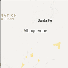
New Mexico
| Local Time | Report Details |
|---|---|
| 4:50 PM MDT | White sands missile range - min in socorro county NM, 89.7 miles S of Albuquerque, NM |
Rhode Island
| Local Time | Report Details |
|---|---|
| 8:35 PM EDT | Tree down on ash street...tree down on dexter rock roa in providence county RI, 7.3 miles NNW of Providence, RI |
North Dakota
| Local Time | Report Details |
|---|---|
| 8:45 PM CDT | Spotter reported strong winds combined with rain to produce very low visibility. spotter said it looked like a blizzard. no hail reporte in morton county ND, 7.6 miles SSW of Bismarck, ND |
| 9:04 PM CDT | Max gust to 58 mph thus far as measured by the asos. heavy rain... near zero visibility... and pea sized hai in burleigh county ND, 0.3 miles N of Bismarck, ND |
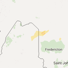
| 9:23 PM CDT | Golf Ball sized hail reported near Mandan, ND, 3.8 miles SW of Bismarck, ND, brief golfball sized hail as the largest. most hailstones were less than one inch diameter or less than quarter sized. |
| 9:40 PM CDT | Quarter sized hail reported near Bismarck, ND, 10 miles SE of Bismarck, ND, quarter sized hail the largest. lots of smaller hail... for about 10 minutes in duration. |
Colorado
| Local Time | Report Details |
|---|---|
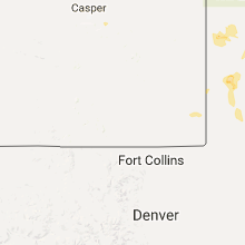
| 9:03 PM MDT | Storm damage reported in kit carson county CO, 64 miles SSE of Yuma, CO |
Minnesota
| Local Time | Report Details |
|---|---|
| 11:23 PM CDT | Quarter sized hail reported near Wilmont, MN, 47 miles ENE of Sioux Falls, SD, some leaves were also ripped down by the hail. |
Iowa
| Local Time | Report Details |
|---|---|
| 3:29 AM CDT | Quarter sized hail reported near Woodward, IA, 27.7 miles NW of Des Moines, IA, estimated nickel to quarter sized hail. in addition estimated 40-45 mph winds. |
Connect with Interactive Hail Maps