

Hail Map for Friday, June 5, 2020

Number of Impacted Households on 6/5/2020
0
Impacted by 1" or Larger Hail
0
Impacted by 1.75" or Larger Hail
0
Impacted by 2.5" or Larger Hail
Square Miles of Populated Area Impacted on 6/5/2020
0
Impacted by 1" or Larger Hail
0
Impacted by 1.75" or Larger Hail
0
Impacted by 2.5" or Larger Hail


Cities Most Affected by Hail Storms of 6/5/2020
| Hail Size | Demographics of Zip Codes Affected | ||||||
|---|---|---|---|---|---|---|---|
| City | Count | Average | Largest | Pop Density | House Value | Income | Age |
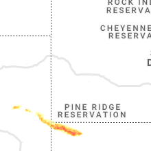
| Lusk, WY | 3 | 2.42 | 2.75 | 0 | $63k | $30.4k | 44.7 |
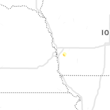
| Treynor, IA | 1 | 2.00 | 2.00 | 18 | $103k | $54.5k | 40.6 |
| Whitney, NE | 1 | 2.00 | 2.00 | 1 | $39k | $30.7k | 49.5 |
| Little Rock, AR | 1 | 1.75 | 1.75 | 2247 | $56k | $30.0k | 32.6 |
| El Dorado, AR | 1 | 1.75 | 1.75 | 74 | $59k | $30.6k | 39.5 |
Hail and Wind Damage Spotted on 6/5/2020
Filter by Report Type:Hail ReportsWind Reports
States Impacted
West Virginia, Tennessee, Mississippi, Arkansas, South Carolina, New York, Georgia, Michigan, Alabama, Colorado, Ohio, New Mexico, Utah, Wyoming, Iowa, Louisiana, Nevada, Nebraska, MontanaWest Virginia
| Local Time | Report Details |
|---|---|
| 2:20 PM EDT | Tree into structure in the 100 block of sheriden driv in jefferson county WV, 69.7 miles W of Baltimore, MD |
Tennessee
| Local Time | Report Details |
|---|---|
| 1:36 PM CDT | Damage to a gas station roof at intersection ofpoplar and collierville-arlington road. time is radar estimate in shelby county TN, 21.8 miles ESE of Memphis, TN |
| 1:37 PM CDT | Storm damage reported in shelby county TN, 8.5 miles SSE of Memphis, TN |
| 2:00 PM CDT | Trees and powerlines down across the memphis metr in shelby county TN, 4.7 miles ESE of Memphis, TN |
Mississippi
| Local Time | Report Details |
|---|---|
| 2:00 PM CDT | Trees and powerlines down on plantation wa in marshall county MS, 33.7 miles SE of Memphis, TN |
| 2:05 PM CDT | Trees and power lines down near i-55 south of hernand in desoto county MS, 26.5 miles S of Memphis, TN |
| 3:00 PM CDT | Extensive tree damage across the city of batesvill in panola county MS, 57.5 miles S of Memphis, TN |
| 3:00 PM CDT | Extensive tree damage across the city of batesvill in panola county MS, 57.5 miles S of Memphis, TN |
| 3:00 PM CDT | Damage to storefront at lamar blvd. and harrison av in lafayette county MS, 61.6 miles SSE of Memphis, TN |
| 3:10 PM CDT | Trees down between blue springs and sherma in union county MS, 63.7 miles N of Starkville, MS |
| 3:14 PM CDT | Large tree uprooted in residents yard. time is radar estimate in pontotoc county MS, 61.6 miles N of Starkville, MS |
| 3:14 PM CDT | Roof damage at the county line grocery stor in lee county MS, 67.8 miles N of Starkville, MS |
| 3:20 PM CDT | Numerous trees down across tow in lee county MS, 63.4 miles N of Starkville, MS |
| 3:25 PM CDT | Numerous trees down across algom in pontotoc county MS, 50.9 miles NNW of Starkville, MS |
| 3:25 PM CDT | Tree damage across ponotoc county in pontotoc county MS, 55.2 miles NNW of Starkville, MS |
| 3:30 PM CDT | Trees and powerlines down at cr 931 amd cr 88 in lee county MS, 61 miles N of Starkville, MS |
| 3:39 PM CDT | Multiple power lines and trees dow in grenada county MS, 63.3 miles WNW of Starkville, MS |
| 3:49 PM CDT | Tree damage across shannon... brewer and aubur in lee county MS, 45 miles N of Starkville, MS |
| 3:50 PM CDT | Multiple trees and power lines dow in grenada county MS, 60.6 miles WNW of Starkville, MS |
| 3:50 PM CDT | Multiple trees dow in grenada county MS, 69.4 miles WNW of Starkville, MS |
| 3:54 PM CDT | Multiple trees dow in grenada county MS, 49.7 miles WNW of Starkville, MS |
| 3:58 PM CDT | Potential roof damage occurred at mississippi state penitentiar in sunflower county MS, 88.6 miles SSW of Memphis, TN |
| 4:02 PM CDT | Multiple trees dow in carroll county MS, 58.5 miles W of Starkville, MS |
| 4:14 PM CDT | Multiple trees down on northside of tow in montgomery county MS, 53.7 miles W of Starkville, MS |
| 4:18 PM CDT | Oak tree down across a back yard in amory m in monroe county MS, 40.9 miles NNE of Starkville, MS |
| 4:21 PM CDT | Part of roof peeled of in montgomery county MS, 53.6 miles W of Starkville, MS |
| 4:27 PM CDT | Multiple trees dow in carroll county MS, 59.3 miles W of Starkville, MS |
| 4:35 PM CDT | A few trees down in the eupora are in webster county MS, 26.9 miles W of Starkville, MS |
| 4:35 PM CDT | Scattered trees down around the county...reported by noxubee s in noxubee county MS, 28.6 miles SSE of Starkville, MS |
| 4:40 PM CDT | Quarter sized hail reported near Columbus, MS, 24.5 miles ENE of Starkville, MS, quarter size hail occurred just outside of columbus air force base. relayed via picture on social media. |
| 4:42 PM CDT | Trees and power lines down throughout the county...reported by bolivar s in bolivar county MS, 96.3 miles NE of Bastrop, LA |
| 4:45 PM CDT | Trees and large limbs were blown down at the dewayne hayes campground. some tents were also overturned at the campground. relayed via social medi in lowndes county MS, 22.1 miles ENE of Starkville, MS |
| 4:45 PM CDT | Scattered tree and power line damage throughout the count in clay county MS, 14.1 miles NE of Starkville, MS |
| 4:58 PM CDT | A tree was blown down in sturgis. relayed via social medi in oktibbeha county MS, 15.9 miles WSW of Starkville, MS |
| 4:58 PM CDT | Trees down off hwy 6 in washington county MS, 80.6 miles NE of Bastrop, LA |
| 5:00 PM CDT | A few trees down mainly over northern lowndes county...reported by lowndes eo in lowndes county MS, 29 miles ENE of Starkville, MS |
| 5:05 PM CDT | Trees down along nepanee r in washington county MS, 75.8 miles NE of Bastrop, LA |
| 5:06 PM CDT | Widespread trees down across the county...reported by attala s in attala county MS, 53 miles WSW of Starkville, MS |
| 5:10 PM CDT | Scattered trees down across the county...reported by holmes s in holmes county MS, 56.4 miles N of Jackson, MS |
| 5:13 PM CDT | Multiple trees dow in holmes county MS, 65.7 miles WSW of Starkville, MS |
| 5:24 PM CDT | A few trees down in winston county...reported by winston e in winston county MS, 27.5 miles SSW of Starkville, MS |
| 5:25 PM CDT | Tree down on hummingbird l in rankin county MS, 6.1 miles S of Jackson, MS |
| 5:29 PM CDT | Trees down across hwy 1 in neshoba county MS, 45.9 miles SSW of Starkville, MS |
| 5:30 PM CDT | A couple of trees down...reported by hinds s in hinds county MS, 15.1 miles SSW of Jackson, MS |
| 5:30 PM CDT | Multiple trees down along ms hwy 1 in winston county MS, 46.3 miles SW of Starkville, MS |
| 5:38 PM CDT | Widespread tree damage across choctaw county...reported by choctaw s in choctaw county MS, 23.5 miles WSW of Starkville, MS |
| 5:49 PM CDT | Mping report of trees uproote in leake county MS, 57.5 miles SSW of Starkville, MS |
| 5:50 PM CDT | A few trees down across old highway 61 in arcol in washington county MS, 69 miles ENE of Bastrop, LA |
| 6:00 PM CDT | A few trees down in canton area...reported by madison s in madison county MS, 23 miles NNE of Jackson, MS |
| 6:05 PM CDT | A tree down across highway 1...reported by sharkey county s in sharkey county MS, 58 miles E of Bastrop, LA |
| 6:36 PM CDT | Mping report of trees dow in rankin county MS, 8.2 miles E of Jackson, MS |
| 6:45 PM CDT | A few trees down across the county...reported by scott county s in scott county MS, 41.3 miles E of Jackson, MS |
| 6:45 PM CDT | Scattered trees down across the county...reported by newton s in newton county MS, 59.8 miles E of Jackson, MS |
| 6:50 PM CDT | Several trees down reported across the county...reported by lauderdale s in lauderdale county MS, 75.8 miles S of Starkville, MS |
| 6:59 PM CDT | A few trees down in the thomastown area...reported by the leake county s in leake county MS, 49.2 miles NE of Jackson, MS |
| 7:00 PM CDT | Multiple trees and power lines down at intersection of county road 16 and highway 15...reported by jasper e in jasper county MS, 56.2 miles ESE of Jackson, MS |
| 7:00 PM CDT | A tree down on residence on ward lane...reported by hinds eo in hinds county MS, 13.2 miles WNW of Jackson, MS |
| 7:10 PM CDT | A few trees and power lines down...reported by warren s in warren county MS, 41.1 miles W of Jackson, MS |
| 7:16 PM CDT | A large tree was blown down near cr 372 near enterpris in clarke county MS, 77.6 miles E of Jackson, MS |
| 7:18 PM CDT | Trees were blown down and power lines were down. a tree was on fire near highway 528 and highway 503 in heidelber in jasper county MS, 72.9 miles ESE of Jackson, MS |
| 7:24 PM CDT | A large tree was blown down and blocked cr 14 in clarke county MS, 82.2 miles W of Camden, AL |
| 7:25 PM CDT | Several trees down across the county...reported by copiah s in copiah county MS, 32.9 miles SSW of Jackson, MS |
| 7:30 PM CDT | A tree was blown down in sandersville on highway 11 at florence church roa in jones county MS, 76.6 miles ESE of Jackson, MS |
| 7:30 PM CDT | Trees were blown down on highway 512 near highway 18 wes in clarke county MS, 80.3 miles ESE of Jackson, MS |
| 7:42 PM CDT | Trees and power lines were blown down on dr. martin luther king drive at east 13th stree in jones county MS, 74.3 miles ESE of Jackson, MS |
| 7:55 PM CDT | A tree down...reported by covington s in covington county MS, 67.3 miles SE of Jackson, MS |
| 8:01 PM CDT | Several trees down across the count in jefferson davis county MS, 57.1 miles SSE of Jackson, MS |
| 8:15 PM CDT | Tree down across highway 552...reported by jefferson county s in jefferson county MS, 60 miles WSW of Jackson, MS |
| 8:42 PM CDT | A tree was blown down and blocked the roadway along garden lane in peta in forrest county MS, 84.7 miles SE of Jackson, MS |
| 8:54 PM CDT | Tree down on highway 84...reported by covington s in covington county MS, 58 miles SE of Jackson, MS |
| 9:08 PM CDT | Large tree across kingston rd near longmire r in adams county MS, 89 miles SW of Jackson, MS |
Arkansas
| Local Time | Report Details |
|---|---|
| 2:05 PM CDT | Quarter sized hail reported near Earle, AR, 26.6 miles WNW of Memphis, TN, quarter size hail between earle and parkin |
| 2:30 PM CDT | Power lines down at sebastian st and plaza ave. tree down on park s in phillips county AR, 53.6 miles SW of Memphis, TN |
| 3:05 PM CDT | Quarter sized hail reported near Aubrey, AR, 56.7 miles WSW of Memphis, TN |
| 4:52 PM CDT | Tree limbs broken and shingles blown off from thunderstorm wind in arkansas county AR, 57.3 miles ESE of Little Rock, AR |
| 5:02 PM CDT | Quarter sized hail reported near Little Rock, AR, 4.7 miles WSW of Little Rock, AR, quarter sized hail was reported at ar children's hospital. |
| 5:08 PM CDT | Golf Ball sized hail reported near Little Rock, AR, 4.7 miles WSW of Little Rock, AR, golfball size hail was reported at uams in downtown little rock. |
| 6:10 PM CDT | Quarter sized hail reported near Stuttgart, AR, 40.1 miles E of Little Rock, AR, at least quarter size hail fell at slovak. |
| 6:35 PM CDT | Tree down on a vehicle on prospect stree in chicot county AR, 44.4 miles ENE of Bastrop, LA |
| 7:35 PM CDT | Awning on a church damaged...reported by chicot s in chicot county AR, 40.9 miles NE of Bastrop, LA |
| 7:50 PM CDT | A tree was reported down on avalon road 2 miles north of star cit in lincoln county AR, 59.1 miles SSE of Little Rock, AR |
| 9:07 PM CDT | Golf Ball sized hail reported near El Dorado, AR, 48.7 miles NW of Bastrop, LA |
| 10:40 PM CDT | Quarter sized hail reported near Prattsville, AR, 32.6 miles SSW of Little Rock, AR |
| 11:20 PM CDT | Powerlines were knocked down in the are in hot spring county AR, 50.9 miles SW of Little Rock, AR |
| 11:32 PM CDT | Quarter sized hail reported near Arkadelphia, AR, 43.2 miles ENE of Nashville, AR, quarter eize hail was reported at lake degray. |
| 11:40 PM CDT | Several trees blown down across the cit in clark county AR, 46.1 miles ENE of Nashville, AR |
| 12:25 AM CDT | Trees were blown down onto highway 26 near deligh in pike county AR, 19.6 miles ENE of Nashville, AR |
South Carolina
| Local Time | Report Details |
|---|---|
| 3:11 PM EDT | Sheriff dispatch reported a tree on a power line at the intersection of penn street and bauskett street in town of edgefiel in edgefield county SC, 20.9 miles N of Augusta, GA |
| 3:16 PM EDT | Sheriff dispatch reported a tree blocking the roadway along country club roa in edgefield county SC, 24.1 miles NNE of Augusta, GA |
| 3:43 PM EDT | Highway patrol reported a tree in the roadway along graham roa in newberry county SC, 66.8 miles NNE of Augusta, GA |
| 3:48 PM EDT | Highway patrol reported roadway blocked by a tree along berley boland road near highway 7 in newberry county SC, 58.4 miles NNE of Augusta, GA |
| 3:52 PM EDT | Highway patrol reported tree in the roadway at the intersection of parr road and four oaks road near i-2 in newberry county SC, 60.8 miles NNE of Augusta, GA |
| 4:37 PM EDT | Sheriff dispatch reported a tree on a power line along gardner street near highway in kershaw county SC, 68.5 miles SSE of Charlotte, NC |
New York
| Local Time | Report Details |
|---|---|
| 3:24 PM EDT | Quarter sized hail reported near Altamont, NY, 8.7 miles SW of Schenectady, NY |
| 3:25 PM EDT | Quarter sized hail reported near Altamont, NY, 8.1 miles SSW of Schenectady, NY |
| 3:58 PM EDT | Wires down. part of tree leaning on hom in albany county NY, 13.9 miles SSE of Schenectady, NY |
Georgia
| Local Time | Report Details |
|---|---|
| 3:56 PM EDT | Tree reported down on roosevelt hwy(ga-41 alt) near coleman creek circl in meriwether county GA, 44.7 miles SSW of Atlanta, GA |
Michigan
| Local Time | Report Details |
|---|---|
| 4:25 PM EDT | Tree downed near britton hwy and kniffen rd in lenawee county MI, 70.8 miles S of Flint, MI |
Alabama
| Local Time | Report Details |
|---|---|
| 4:05 PM CDT | A large tree was snapped in muscle shoals. report relayed via social media... and time estimated based on rada in colbert county AL, 4.6 miles SSE of Florence, AL |
Colorado
| Local Time | Report Details |
|---|---|
| 3:09 PM MDT | Storm damage reported in montezuma county CO, 46.5 miles NNW of Farmington, NM |
| 5:18 PM MDT | Asos station kcez cortez municipal airpor in montezuma county CO, 45.9 miles NNW of Farmington, NM |
| 5:54 PM MDT | Storm damage reported in mesa county CO, 18.2 miles ENE of Grand Junction, CO |
| 7:35 PM MDT | Storm damage reported in mesa county CO, 6.7 miles E of Grand Junction, CO |
| 7:35 PM MDT | Storm damage reported in mesa county CO, 6.7 miles E of Grand Junction, CO |
| 7:40 PM MDT | Large tree uprooted and blown dow in mesa county CO, 2.7 miles ESE of Grand Junction, CO |
| 7:40 PM MDT | Downed power line across the roa in mesa county CO, 11.4 miles NW of Grand Junction, CO |
| 7:45 PM MDT | Downed power line across the roa in mesa county CO, 3.6 miles SE of Grand Junction, CO |
| 7:45 PM MDT | Storm damage reported in mesa county CO, 3.4 miles NW of Grand Junction, CO |
| 8:24 PM MDT | Mesonet station co098 139s034 douglas pas in garfield county CO, 38.9 miles NNW of Grand Junction, CO |
| 9:12 PM MDT | Asos station keeo meeker airpor in rio blanco county CO, 36.5 miles SSW of Craig, CO |
| 10:23 PM MDT | Mesonet station lodc2 ladore... greystone 11n in moffat county CO, 61.7 miles SSE of Rock Springs, WY |
| 10:28 PM MDT | Mesonet station tt290 rbfmz portable in moffat county CO, 53.4 miles SSE of Rock Springs, WY |
Ohio
| Local Time | Report Details |
|---|---|
| 5:35 PM EDT | Tweet showed tree was blown down and destroyed picnic pavilion at water works park in cuyahoga falls. multiple trees also downed in nearby neighborhoods. report time es in summit county OH, 27.9 miles SSE of Cleveland, OH |
| 5:40 PM EDT | Social media report and photos of 5 or 6 trees and tree limbs down from the circle of tallmadge and south on ohio state route 91. time is estimated via rada in summit county OH, 30.8 miles SSE of Cleveland, OH |
| 6:56 PM EDT | Corrects previous tstm wnd dmg report from 2 n louisville. odot reported oh 44 closed between easton street and us 62 due to downed power lines. spotter reported numero in stark county OH, 49.2 miles SSE of Cleveland, OH |
New Mexico
| Local Time | Report Details |
|---|---|
| 4:00 PM MDT | Elevation 639 in san juan county NM, 31.4 miles E of Farmington, NM |
| 12:55 AM MDT | Kbrg awo in valencia county NM, 31.6 miles SSW of Albuquerque, NM |
Utah
| Local Time | Report Details |
|---|---|
| 4:08 PM MDT | Storm damage reported in sevier county UT, 3.3 miles E of Monroe, UT |
| 4:08 PM MDT | Storm damage reported in utah county UT, 38.3 miles SSE of Salt Lake City, UT |
| 4:20 PM MDT | Udot mesonet station - i-15 at mp 215 lampson canyon in juab county UT, 59.2 miles W of Price, UT |
| 4:30 PM MDT | Sanpete - agrimet mesonet station in sanpete county UT, 36 miles W of Price, UT |
| 4:37 PM MDT | Storm damage reported in sanpete county UT, 46.6 miles WSW of Price, UT |
| 4:37 PM MDT | Storm damage reported in sevier county UT, 17.4 miles NE of Monroe, UT |
| 4:40 PM MDT | Storm damage reported in duchesne county UT, 42.1 miles N of Price, UT |
| 4:51 PM MDT | Currant creek peak avalanche mesonet station reported a max wind gust of 62 mph in the last hour. time estimated from radar. elevation - 10547 ft in wasatch county UT, 45.5 miles SE of Salt Lake City, UT |
| 5:04 PM MDT | Mesonet station wrru1 white ree in washington county UT, 13.6 miles NE of Saint George, UT |
| 5:30 PM MDT | 3 power poles knocked down across utah state highway 162. semi-truck then was entangled in the downed power line in san juan county UT, 65.4 miles WNW of Farmington, NM |
| 5:35 PM MDT | Windy peak avalanche mesonet site reported max gust in the last hour of 63 mph. time estimated from radar. elevation - 10662 feet in summit county UT, 45.9 miles E of Salt Lake City, UT |
| 5:41 PM MDT | Storm damage reported in utah county UT, 38.3 miles SSE of Salt Lake City, UT |
| 6:00 PM MDT | Mesonet station vrh 3.5 s faust (tooele in tooele county UT, 50.6 miles SSW of Salt Lake City, UT |
| 6:05 PM MDT | I-80 mile post 30. udot reports semi tipped over. crosswind signs were on video message board in tooele county UT, 83 miles W of Salt Lake City, UT |
| 6:10 PM MDT | I-80 mile post 77 to 79 reports of 3 semis rolled over. crosswind signs posted on video message board. highway restricted to high profile vehicl in tooele county UT, 38.4 miles W of Salt Lake City, UT |
| 6:14 PM MDT | Pleasant grove raws. reported max gust in the last hour... time estimated from rada in utah county UT, 23.9 miles SSE of Salt Lake City, UT |
| 6:15 PM MDT | Awos station kbdg blandin in san juan county UT, 91.2 miles NW of Farmington, NM |
| 6:18 PM MDT | Storm damage reported in salt lake county UT, 20.7 miles S of Salt Lake City, UT |
| 6:18 PM MDT | Storm damage reported in salt lake county UT, 2.6 miles NE of Salt Lake City, UT |
| 6:18 PM MDT | Storm damage reported in tooele county UT, 64.4 miles WSW of Salt Lake City, UT |
| 6:40 PM MDT | Mesonet station utqry 2.3 e sugarhouse (utah dot in salt lake county UT, 6.5 miles ESE of Salt Lake City, UT |
| 6:49 PM MDT | Mesonet station ew5685 salt lake cit in salt lake county UT, 2.6 miles NE of Salt Lake City, UT |
| 6:51 PM MDT | Awos station ksgu st george muni airpor in washington county UT, 4.4 miles SE of Saint George, UT |
| 6:52 PM MDT | Mesonet station badu1 badger sprin in washington county UT, 20.5 miles W of Saint George, UT |
| 7:05 PM MDT | Mesonet station kcc13 3.8 nw magna (kennecott in salt lake county UT, 12.7 miles W of Salt Lake City, UT |
| 7:13 PM MDT | Report of downed power lines across i-15 at 2100 s in ogden. this resulted in two traffic accidents... a grass fire on the side of the interstate... and i-15 was shut d in weber county UT, 33.1 miles N of Salt Lake City, UT |
| 7:15 PM MDT | Storm damage reported in box elder county UT, 42.5 miles WNW of Salt Lake City, UT |
| 7:25 PM MDT | Fremont island mesonet in weber county UT, 35.5 miles NW of Salt Lake City, UT |
| 7:30 PM MDT | Report via social medi in grand county UT, 63.4 miles WSW of Grand Junction, CO |
| 7:30 PM MDT | Storm damage reported in grand county UT, 66.9 miles WSW of Grand Junction, CO |
| 7:35 PM MDT | Semi blown over near mile marker 183. recent wind gusts over 70 mph reported at canyonlands airport just south of this locatio in grand county UT, 66.5 miles W of Grand Junction, CO |
Wyoming
| Local Time | Report Details |
|---|---|
| 6:06 PM MDT | Mesonet station wy34 1.8 sw leroy (wydot in uinta county WY, 75.1 miles ENE of Salt Lake City, UT |
| 6:16 PM MDT | Mesonet station wy34 1.8 sw leroy (wydot in uinta county WY, 75.1 miles ENE of Salt Lake City, UT |
| 6:28 PM MDT | Wdot mesonet - i-80 at church butte in uinta county WY, 47.8 miles WSW of Rock Springs, WY |
| 6:31 PM MDT | Muddy creek raws peak wind gust of 58 mph in the last hour. time estimated from rada in uinta county WY, 70 miles W of Rock Springs, WY |
| 6:40 PM MDT | Ping Pong Ball sized hail reported near Lusk, WY, 88.3 miles SW of Rapid City, SD, mile marker 172 to 178 on hwy 85 observed hail from 1 inch to 1.5 inch diameter. |
| 6:40 PM MDT | Baseball sized hail reported near Lusk, WY, 81.7 miles NNW of Scottsbluff, NE, public residence received baseball size hail. radar estimated location off thompson rd. |
| 6:52 PM MDT | Golf Ball sized hail reported near Lusk, WY, 77.5 miles NNW of Scottsbluff, NE, golf ball sized hail on indian creek road. |
| 6:55 PM MDT | Asos station kbpi big piney airpor in sublette county WY, 82.1 miles NNW of Rock Springs, WY |
| 7:15 PM MDT | Baseball sized hail reported near Lusk, WY, 77.3 miles NNW of Scottsbluff, NE, baseball sized hail reported with multiple tree limbs down at property. |
| 10:50 PM MDT | Dixon airport asos wind gust of 60mp in carbon county WY, 36.4 miles N of Craig, CO |
| 12:35 AM MDT | Asos station kcpr casper airpor in natrona county WY, 8 miles WNW of Casper, WY |
| 1:00 AM MDT | Asos station klnd lander airpor in fremont county WY, 22.7 miles SW of Riverton, WY |
| 1:25 AM MDT | Asos station kriw riverton airpor in fremont county WY, 5.5 miles NW of Riverton, WY |
| 4:21 AM MDT | Asos station kbyg buffalo airpor in johnson county WY, 60.5 miles W of Gillette, WY |
Iowa
| Local Time | Report Details |
|---|---|
| 7:09 PM CDT | Quarter sized hail reported near Mc Clelland, IA, 15.8 miles E of Omaha, NE, substantial amount of nickel to quarter size hail observed. |
| 7:13 PM CDT | Half Dollar sized hail reported near Mc Clelland, IA, 17.4 miles E of Omaha, NE, estimated half dollar in diameter based on a picture from social media. |
| 7:37 PM CDT | Hen Egg sized hail reported near Treynor, IA, 17.3 miles E of Omaha, NE |
Louisiana
| Local Time | Report Details |
|---|---|
| 7:10 PM CDT | Scattered trees and power lines down across the parish...reported by west carroll s in west carroll county LA, 31.1 miles E of Bastrop, LA |
| 7:10 PM CDT | A few trees down in the monticello community...reported by east carroll s in east carroll county LA, 34.1 miles E of Bastrop, LA |
| 7:30 PM CDT | A few trees down across the parish...reported by morehouse paris in morehouse county LA, 0.3 miles WNW of Bastrop, LA |
| 7:45 PM CDT | A few trees and power lines down...reported by richland s in richland county LA, 22.5 miles SSE of Bastrop, LA |
Nevada
| Local Time | Report Details |
|---|---|
| 6:42 PM PDT | Corrects previous non-tstm wnd gst report from 6 s clover valley. mesonet station wspnv 6.3 s clover valley (nv dot in elko county NV, 38.5 miles E of Elko, NV |
Nebraska
| Local Time | Report Details |
|---|---|
| 8:44 PM MDT | Hen Egg sized hail reported near Whitney, NE, 66.5 miles NNE of Scottsbluff, NE |
Montana
| Local Time | Report Details |
|---|---|
| 2:25 AM MDT | Quarter sized hail reported near Larslan, MT, 31.7 miles NE of Glasgow, MT, hail began as large as quarters... lasting for just a few minutes... then diminshed to the size of dimes until 235 am. sustained winds of 35 mph with gusts to 52 mph. |
Connect with Interactive Hail Maps