

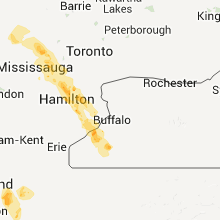
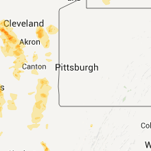
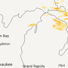
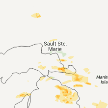
Hail Map for Tuesday, June 7, 2011

Number of Impacted Households on 6/7/2011
0
Impacted by 1" or Larger Hail
0
Impacted by 1.75" or Larger Hail
0
Impacted by 2.5" or Larger Hail
Square Miles of Populated Area Impacted on 6/7/2011
0
Impacted by 1" or Larger Hail
0
Impacted by 1.75" or Larger Hail
0
Impacted by 2.5" or Larger Hail


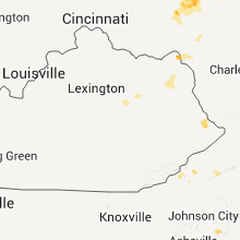

Cities Most Affected by Hail Storms of 6/7/2011
| Hail Size | Demographics of Zip Codes Affected | ||||||
|---|---|---|---|---|---|---|---|
| City | Count | Average | Largest | Pop Density | House Value | Income | Age |
| Elyria, OH | 2 | 1.88 | 2.00 | 1367 | $99k | $39.8k | 39.4 |
| Braddock, ND | 1 | 2.00 | 2.00 | 1 | $13k | $25.9k | 57.3 |
| Wheelersburg, OH | 1 | 1.75 | 1.75 | 170 | $81k | $33.0k | 40.6 |
| Tylertown, MS | 1 | 1.75 | 1.75 | 42 | $58k | $22.7k | 37.9 |
| Granville, OH | 1 | 1.75 | 1.75 | 217 | $175k | $70.4k | 37.0 |
| Hattiesburg, MS | 1 | 1.75 | 1.75 | 241 | $55k | $22.8k | 28.8 |
| Roxie, MS | 1 | 1.75 | 1.75 | 11 | $41k | $22.4k | 37.8 |
| Glen Ullin, ND | 1 | 1.75 | 1.75 | 1 | $34k | $28.6k | 51.0 |
Hail and Wind Damage Spotted on 6/7/2011
Filter by Report Type:Hail ReportsWind Reports
States Impacted
Ohio, Pennsylvania, New York, Montana, West Virginia, Mississippi, Florida, Louisiana, Kentucky, Alabama, North Carolina, Virginia, North Dakota, Michigan, Georgia, WisconsinOhio
| Local Time | Report Details |
|---|---|
| 12:10 PM UTC | Numerous trees and power lines down across trumbull count in trumbull county OH, 48.8 miles ESE of Cleveland, OH |
| 12:40 PM UTC | Trees dow in cuyahoga county OH, 6.8 miles E of Cleveland, OH |
| 12:45 PM UTC | Quarter sized hail reported near Ravenna, OH, 36.8 miles SE of Cleveland, OH |
| 12:55 PM UTC | Quarter sized hail reported near Newton Falls, OH, 43.3 miles ESE of Cleveland, OH |
| 1:05 PM UTC | Quarter sized hail reported near Lorain, OH, 24.8 miles W of Cleveland, OH |
| 1:08 PM UTC | Golf Ball sized hail reported near Lorain, OH, 24.2 miles WSW of Cleveland, OH |
| 1:12 PM UTC | Quarter sized hail reported near Elyria, OH, 23.4 miles WSW of Cleveland, OH |
| 1:20 PM UTC | Trees and power lines down on rt 62 near columbiana mahoning co. border in columbiana county OH, 56.3 miles NW of Pittsburgh, PA |
| 1:23 PM UTC | Quarter sized hail reported near Elyria, OH, 23.4 miles WSW of Cleveland, OH |
| 1:25 PM UTC | Numerous trees down on sr 14 west of columbiana in columbiana county OH, 47.9 miles NW of Pittsburgh, PA |
| 1:30 PM UTC | Hen Egg sized hail reported near Elyria, OH, 24.3 miles WSW of Cleveland, OH |
| 1:35 PM UTC | Multiple trees down in the city of allianc in stark county OH, 50.7 miles SE of Cleveland, OH |
| 1:40 PM UTC | Ping Pong Ball sized hail reported near Amherst, OH, 28.9 miles WSW of Cleveland, OH |
| 1:42 PM UTC | Large tree and other numerous trees dow in mahoning county OH, 57.1 miles NW of Pittsburgh, PA |
| 2:00 PM UTC | Trees down in columbiana county OH, 46.6 miles WNW of Pittsburgh, PA |
| 2:15 PM UTC | Trees dow in stark county OH, 50.7 miles SE of Cleveland, OH |
| 2:25 PM UTC | Numerous trees and power lines down in strasburg in tuscarawas county OH, 63.7 miles S of Cleveland, OH |
| 2:28 PM UTC | Trees down in bloomingdale and unionport in jefferson county OH, 43.9 miles W of Pittsburgh, PA |
| 2:35 PM UTC | Trees dow in wayne county OH, 45.3 miles S of Cleveland, OH |
| 2:38 PM UTC | Quarter sized hail reported near Nova, OH, 46.1 miles SW of Cleveland, OH |
| 3:00 PM UTC | Quarter sized hail reported near New London, OH, 47.5 miles SW of Cleveland, OH |
| 3:15 PM UTC | Quarter sized hail reported near Millersburg, OH, 66.9 miles S of Cleveland, OH |
| 3:20 PM UTC | Trees and power lines down in martins ferry in belmont county OH, 44.8 miles WSW of Pittsburgh, PA |
| 3:40 PM UTC | Some downed trees reported along township road in coshocton county OH, 64.4 miles ENE of Columbus, OH |
| 4:00 PM UTC | Trees down in woodsfield in monroe county OH, 75.7 miles SW of Pittsburgh, PA |
| 4:38 PM UTC | 3 to 4 trees down at 310 6th street in marietta in washington county OH, 74.5 miles N of Charleston, WV |
| 1:12 PM EDT | Golf Ball sized hail reported near Granville, OH, 27.7 miles ENE of Columbus, OH |
| 5:13 PM UTC | Half Dollar sized hail reported near Heath, OH, 30.2 miles E of Columbus, OH |
| 5:18 PM UTC | Trees down and uprooted in washington county OH, 66.9 miles N of Charleston, WV |
| 1:20 PM EDT | Quarter sized hail reported near Granville, OH, 27.7 miles ENE of Columbus, OH |
| 5:20 PM UTC | Quarter sized hail reported near Newark, OH, 29.8 miles ENE of Columbus, OH, between newark and granville on highway 16. |
| 1:22 PM EDT | Half Dollar sized hail reported near Hebron, OH, 27.2 miles E of Columbus, OH |
| 5:39 PM UTC | Quarter sized hail reported near Millersport, OH, 25 miles E of Columbus, OH |
| 6:00 PM UTC | Quarter sized hail reported near Lancaster, OH, 28 miles SE of Columbus, OH |
| 6:34 PM UTC | Tree down on sr 374. also several other trees down across the count in hocking county OH, 41.9 miles SSE of Columbus, OH |
| 7:19 PM UTC | Ping Pong Ball sized hail reported near Powell, OH, 14.1 miles NNW of Columbus, OH |
| 7:24 PM UTC | Multiple trees down across roads in jackson and south of tow in jackson county OH, 66 miles SSE of Columbus, OH |
| 7:24 PM UTC | A few trees down on rocky rd...marietta rd...and chapel creek r in ross county OH, 40.4 miles S of Columbus, OH |
| 7:50 PM UTC | Quarter sized hail reported near Ironton, OH, 57.1 miles WNW of Charleston, WV |
| 7:50 PM UTC | Golf Ball sized hail reported near Wheelersburg, OH, 70.6 miles WNW of Charleston, WV |
| 8:02 PM UTC | Half Dollar sized hail reported near Wheelersburg, OH, 69.7 miles WNW of Charleston, WV |
| 8:10 PM UTC | Quarter sized hail reported near Franklin Furnace, OH, 68.1 miles WNW of Charleston, WV |
| 8:22 PM UTC | Quarter sized hail reported near Galloway, OH, 9.1 miles WSW of Columbus, OH, in galloway oh. |
Pennsylvania
| Local Time | Report Details |
|---|---|
| 12:20 PM UTC | Trees down in sharon in mercer county PA, 60.4 miles NNW of Pittsburgh, PA |
| 12:30 PM UTC | Trees...branches and wires down in mercer county PA, 64.9 miles E of Cleveland, OH |
New York
| Local Time | Report Details |
|---|---|
| 12:30 PM UTC | Tree blown dow in erie county NY, 4.3 miles SE of Buffalo, NY |
| 6:57 AM UTC | Quarter sized hail reported near Dunkirk, NY, 36 miles SW of Buffalo, NY |
Montana
| Local Time | Report Details |
|---|---|
| 4:12 PM UTC | Winds estimated around 50 mph after midnight. dime sized hail fell for about 3 minutes. a tall healthy cottonwood tree was uprooted over nigh in valley county MT, 33 miles NE of Glasgow, MT |
West Virginia
| Local Time | Report Details |
|---|---|
| 4:44 PM UTC | Trees down on route 2 near st. marys in pleasants county WV, 76.2 miles NNE of Charleston, WV |
| 4:51 PM UTC | Trees down on route 2 near the city of polecat in pleasants county WV, 70.5 miles NNE of Charleston, WV |
| 4:52 PM UTC | Quarter sized hail reported near St Marys, WV, 71.5 miles NNE of Charleston, WV |
| 5:22 PM UTC | Small branches broken in wirt county WV, 44.2 miles NNE of Charleston, WV |
| 6:15 PM UTC | Numerous trees down in spencer are in roane county WV, 35.2 miles NNE of Charleston, WV |
| 6:29 PM UTC | Numerous trees down in are in roane county WV, 35.2 miles NNE of Charleston, WV |
| 6:36 PM UTC | Power lines and poles down across rte 35 near the drag stri in mason county WV, 31.2 miles NW of Charleston, WV |
| 7:02 PM UTC | Trees and power lines down at greenbrier st and deitrick blvd in kanawha county WV, 0.5 miles E of Charleston, WV |
| 7:15 PM UTC | Trees down across pioneer dr and deerfield ln in kanawha county WV, 9.4 miles NW of Charleston, WV |
| 7:20 PM UTC | Trees and power lines down across rte 6 in kanawha county WV, 13.6 miles SE of Charleston, WV |
| 9:05 PM UTC | Trees down in camp creek state par in mercer county WV, 64.9 miles SSE of Charleston, WV |
| 9:06 PM UTC | Multiple trees down in the town of bud in wyoming county WV, 58.9 miles SSE of Charleston, WV |
Mississippi
| Local Time | Report Details |
|---|---|
| 6:44 PM UTC | Couple trees down off hwy 28 in simpson county MS, 31.6 miles SSE of Jackson, MS |
| 7:20 PM UTC | Minor damage to police/fire training academy. some power outage in forrest county MS, 81.3 miles WNW of Mobile, AL |
| 7:22 PM UTC | Tree down on roy tucker roads and several trees down john odom road in forrest county MS, 83.8 miles WNW of Mobile, AL |
| 7:35 PM UTC | Powerlines down. broadcast media reports much of city without powe in copiah county MS, 32.6 miles SSW of Jackson, MS |
| 7:40 PM UTC | Oak tree reported blown down on bay street that took out a powerline. dime to penny size hail also observe in perry county MS, 69.7 miles NW of Mobile, AL |
| 7:44 PM UTC | Couple trees down off hwy 28 in simpson county MS, 31.6 miles SSE of Jackson, MS |
| 7:45 PM UTC | 2 trees down on john evan road in forrest county MS, 81 miles WNW of Mobile, AL |
| 7:53 PM UTC | 62 mph wind gust measured at bobby l. chain airpor in forrest county MS, 82 miles WNW of Mobile, AL |
| 7:55 PM UTC | A few trees down off hwy 2 in jefferson county MS, 65.6 miles SW of Jackson, MS |
| 8:02 PM UTC | A couple trees down in jones county MS, 76.6 miles SE of Jackson, MS |
| 8:29 PM UTC | Quarter sized hail reported near Collins, MS, 61.1 miles SE of Jackson, MS, on mccarty ln |
| 8:29 PM UTC | A few trees down in hinds county MS, 29.2 miles WSW of Jackson, MS |
| 8:30 PM UTC | Power lines down at camp shelby in forrest county MS, 77.8 miles WNW of Mobile, AL |
| 8:34 PM UTC | A couple trees down in jones county MS, 74.1 miles SE of Jackson, MS |
| 8:40 PM UTC | Powerlines down at the intersection of oak street and bush roa in hinds county MS, 22.7 miles WSW of Jackson, MS |
| 8:40 PM UTC | A few trees were down in lincoln county MS, 62.9 miles S of Jackson, MS |
| 8:43 PM UTC | Quarter sized hail reported near Prentiss, MS, 49.2 miles SSE of Jackson, MS, along oak grove rd |
| 8:45 PM UTC | Trees down old brandon road at rose garden...old brandon road at crestview and highway 80 at pirates cov in rankin county MS, 6.6 miles ESE of Jackson, MS |
| 8:46 PM UTC | Golf Ball sized hail reported near Hattiesburg, MS, 75.5 miles WNW of Mobile, AL |
| 8:48 PM UTC | Quarter sized hail reported near Hattiesburg, MS, 76.9 miles WNW of Mobile, AL |
| 8:50 PM UTC | A few power lines down along mcnair r in franklin county MS, 67.5 miles SW of Jackson, MS |
| 8:55 PM UTC | Power pole and lines down near ellis ave in hinds county MS, 2.3 miles NW of Jackson, MS |
| 8:55 PM UTC | Several trees down on pierce road to the west of highway 49 in forrest county MS, 76.9 miles WNW of Mobile, AL |
| 9:00 PM UTC | Quarter sized hail reported near Magee, MS, 40.6 miles SSE of Jackson, MS, quarter sized hail reported along garner road near the simpson county/jefferson davis county line. |
| 9:00 PM UTC | Powerlines down at i-220 overpass at livingston road in hinds county MS, 7.2 miles NNW of Jackson, MS |
| 9:05 PM UTC | Golf Ball sized hail reported near Roxie, MS, 76.6 miles SW of Jackson, MS, two reports hail near the roxie community...quarter to golf ball size |
| 9:11 PM UTC | Quarter sized hail reported near Magee, MS, 40.2 miles SE of Jackson, MS, quarter sized hail reported along varner road. |
| 9:15 PM UTC | Few trees down near tilto in lawrence county MS, 62 miles S of Jackson, MS |
| 9:15 PM UTC | Trees downed old brandon road and whisper oak crossin in rankin county MS, 5.7 miles ESE of Jackson, MS |
| 9:15 PM UTC | Tree downed across highway 80 in rankin county just before hinds county lin in rankin county MS, 3.1 miles SE of Jackson, MS |
| 9:20 PM UTC | Trees down along airport rd in simpson county MS, 27.3 miles SSE of Jackson, MS |
| 9:25 PM UTC | Trees down off athens r in simpson county MS, 31.3 miles SE of Jackson, MS |
| 9:33 PM UTC | A couple trees down around edwards in hinds county MS, 24.6 miles W of Jackson, MS |
| 9:35 PM UTC | Tree reported down on county road 28 in clarke county MS, 85.4 miles ESE of Jackson, MS |
| 10:10 PM UTC | Tree down and powerlines down on 108 prescott driv in rankin county MS, 9.6 miles ESE of Jackson, MS |
| 10:10 PM UTC | Tree reported down on highway 18 and west sunset driv in rankin county MS, 9.2 miles ESE of Jackson, MS |
| 10:25 PM UTC | Golf Ball sized hail reported near Tylertown, MS, 79.2 miles N of New Orleans, LA |
| 10:33 PM UTC | Ping Pong Ball sized hail reported near Morton, MS, 37 miles E of Jackson, MS, many large limbs down as well. |
| 10:35 PM UTC | Tree fell onto a house at the intersection of 37th avenue and 20th street. trees fell on powerlines on 4100 40th street and the intersection of 23rd avenue and 23rd str in lauderdale county MS, 75.1 miles S of Starkville, MS |
| 10:40 PM UTC | Large tree down on livingston r in hinds county MS, 7.8 miles N of Jackson, MS |
| 10:45 PM UTC | Powerlines down at the intersection of oak street and bush roa in hinds county MS, 22.7 miles WSW of Jackson, MS |
| 11:10 PM UTC | Light pole snapped and transformers on fire at old hillsboro road and hillsboro vfw roa in scott county MS, 40.8 miles ENE of Jackson, MS |
| 11:23 PM UTC | Quarter sized hail reported near Canton, MS, 34.6 miles NE of Jackson, MS, a large tree was also blown down in the yard off branson rd. |
| 11:37 PM UTC | Ping Pong Ball sized hail reported near Carthage, MS, 55.2 miles ENE of Jackson, MS |
| 12:55 AM UTC | Shingles were pealed off a roof and lawn furniture was blown across the yard...dime hail also occurre in sunflower county MS, 78.1 miles NNW of Jackson, MS |
Florida
| Local Time | Report Details |
|---|---|
| 7:00 PM UTC | Tree down on a car on bay avenue across from rosenwald high school in bay county FL, 45.4 miles ESE of Miramar Beach, FL |
| 7:10 PM UTC | Tree down across the road at 23rd street and bayview avenu in bay county FL, 41.5 miles ESE of Miramar Beach, FL |
Louisiana
| Local Time | Report Details |
|---|---|
| 7:36 PM UTC | Quarter sized hail reported near New Orleans, LA, 1.1 miles N of New Orleans, LA, nickel to quarter size hail near industrial canal and mississippi river gulf outlet area. |
| 10:55 PM UTC | Outflow boundary from nearby storm blew trees and powerlines down. power outages until late in the evening. quarter size hail also reporte in madison county LA, 49.3 miles ESE of Bastrop, LA |
| 11:30 PM UTC | Tree down at stage coach road and fire tower roa in de soto county LA, 30.2 miles S of Shreveport, LA |
| 11:47 PM UTC | Tree down on hwy in de soto county LA, 25.2 miles SSW of Shreveport, LA |
| 11:47 PM UTC | Tree down in gloster east of keach in de soto county LA, 23.6 miles SSW of Shreveport, LA |
| 12:00 AM UTC | Quarter sized hail reported near Oak Grove, LA, 19.6 miles E of Bastrop, LA, hailed for 10-15 minutes. |
| 12:10 AM UTC | Several trees and powerlines down along roy rd and shepherd rd from a microburst. damage extended for about 1 mile along both of these roads. several homes suffered min in caddo county LA, 7.5 miles NW of Shreveport, LA |
| 12:10 AM UTC | Few trees down with a tree down on a house on sydney rd. a gas station had roof damage at intersection of hilry huckaby and david raines rd in caddo county LA, 6.8 miles WNW of Shreveport, LA |
| 12:44 AM UTC | Quarter sized hail reported near Denham Springs, LA, 60 miles NW of New Orleans, LA, quarter sized hail reported 4 miles southeast of denham springs. |
Kentucky
| Local Time | Report Details |
|---|---|
| 8:16 PM UTC | Trees down on power lines and power lines on fire on crestview r in greenup county KY, 58.6 miles W of Charleston, WV |
| 8:36 PM UTC | Trees and power lines down near stinson in carter county KY, 66.9 miles W of Charleston, WV |
| 8:39 PM UTC | Trees down across rte 784 in greenup county KY, 68.7 miles W of Charleston, WV |
Alabama
| Local Time | Report Details |
|---|---|
| 9:14 PM UTC | Shingles blown off roof of webj radio studi in escambia county AL, 61 miles SSE of Camden, AL |
| 9:15 PM UTC | Numerous trees reported down around the city of brewto in escambia county AL, 61.5 miles SSE of Camden, AL |
| 9:15 PM UTC | Large tree blown onto mobile hom in escambia county AL, 63.6 miles SSE of Camden, AL |
| 9:43 PM UTC | Quarter sized hail reported near Uriah, AL, 48.7 miles SSW of Camden, AL, quarter size hail reported in uriah. |
| 10:13 PM UTC | Numerous trees reported blown down in several areas across southern monroe count in monroe county AL, 49.6 miles NE of Mobile, AL |
| 10:15 PM UTC | Numerous trees reported down around the city of brewto in escambia county AL, 61.5 miles SSE of Camden, AL |
| 10:25 PM UTC | Numerous trees reported blown dow in washington county AL, 49.8 miles NNW of Mobile, AL |
| 11:08 PM UTC | Quarter sized hail reported near McIntosh, AL, 42 miles N of Mobile, AL, quarter size hail reported. |
| 11:20 PM UTC | Several trees blown dow in washington county AL, 43 miles NNW of Mobile, AL |
| 11:27 PM UTC | Several trees blown down around the area. tree also blown over onto hom in washington county AL, 40 miles NNW of Mobile, AL |
North Carolina
| Local Time | Report Details |
|---|---|
| 9:30 PM UTC | 2 trees down on hwy 143/sweetwater rd before hwy 28. marble size hai in graham county NC, 45.6 miles SSE of Knoxville, TN |
| 10:53 PM UTC | Two trees down along route 268. several other trees also down between pinnacle and westfiel in stokes county NC, 62.9 miles SSW of Roanoke, VA |
| 11:10 PM UTC | 1-2 ft diameter tree down. 2 other tree tops broken off larger trees in surry county NC, 63.6 miles SW of Roanoke, VA |
| 11:10 PM UTC | 12 inch diameter branch blown down blocking rt 52 north of greenhill r in surry county NC, 63.6 miles SW of Roanoke, VA |
| 12:00 AM UTC | Trees and large limbs on blue ridge pa in mitchell county NC, 51.5 miles SSE of Bristol, TN |
Virginia
| Local Time | Report Details |
|---|---|
| 9:45 PM UTC | A few trees down on highway 65 in fort blackmore. reported by dispatc in scott county VA, 23.9 miles WNW of Bristol, TN |
| 9:55 PM UTC | Tree down on route 708 in giles county VA, 42.4 miles W of Roanoke, VA |
| 10:05 PM UTC | Tree down on route 616 in tazewell county VA, 49.7 miles NNE of Bristol, TN |
| 10:20 PM UTC | Quarter sized hail reported near Ararat, VA, 49.8 miles SSW of Roanoke, VA, hail began 620 pm and continued off and on through 640 pm. the largest hail was quarter sized. |
| 10:32 PM UTC | Several trees and powerlines down on and along jasper creek road. reported by dispatc in washington county VA, 16.9 miles NNE of Bristol, TN |
| 10:36 PM UTC | Trees down on route 614 in patrick county VA, 51.9 miles SW of Roanoke, VA |
| 10:56 PM UTC | Several trees and powerlines down on and along haskell station road near the junction with reedy creek road. reported by dispatc in washington county VA, 6.1 miles NNE of Bristol, TN |
North Dakota
| Local Time | Report Details |
|---|---|
| 10:40 PM UTC | Quarter sized hail reported near Richardton, ND, 66.2 miles W of Bismarck, ND |
| 10:46 PM UTC | Strong winds estimated 60 mph or greater spun a truck aroun in morton county ND, 60.1 miles W of Bismarck, ND |
| 11:06 PM UTC | Golf Ball sized hail reported near Glen Ullin, ND, 47.9 miles W of Bismarck, ND |
| 11:40 PM UTC | Quarter sized hail reported near New Salem, ND, 34.3 miles WNW of Bismarck, ND, shave report. late report from 6-7-11. |
| 11:54 PM UTC | Hen Egg sized hail reported near Braddock, ND, 34.7 miles ESE of Bismarck, ND |
Michigan
| Local Time | Report Details |
|---|---|
| 10:58 PM UTC | Quarter sized hail reported near Allis, MI, 36.1 miles WNW of Alpena, MI, hail covering the ground. |
Georgia
| Local Time | Report Details |
|---|---|
| 11:05 PM UTC | Several telephone poles and traffic signals blown down in bainbridg in decatur county GA, 37 miles NNW of Tallahassee, FL |
Wisconsin
| Local Time | Report Details |
|---|---|
| 5:26 AM UTC | Quarter sized hail reported near Monona, WI, 3.3 miles ESE of Madison, WI, reported possible funnel cloud north of location...damage to power lines...roof damage...down trees. winds estimated to around 65 mph. |
| 10:55 AM UTC | Public reported about a half dozen large trees blown over by thunderstorm winds near the intersection of highmound rd and county highway b. delayed repor in jefferson county WI, 38.8 miles E of Madison, WI |
Connect with Interactive Hail Maps