

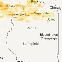
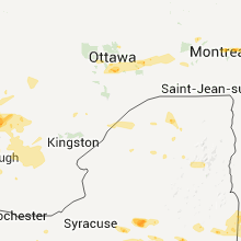
Hail Map for Wednesday, June 8, 2011

Number of Impacted Households on 6/8/2011
0
Impacted by 1" or Larger Hail
0
Impacted by 1.75" or Larger Hail
0
Impacted by 2.5" or Larger Hail
Square Miles of Populated Area Impacted on 6/8/2011
0
Impacted by 1" or Larger Hail
0
Impacted by 1.75" or Larger Hail
0
Impacted by 2.5" or Larger Hail


Cities Most Affected by Hail Storms of 6/8/2011
| Hail Size | Demographics of Zip Codes Affected | ||||||
|---|---|---|---|---|---|---|---|
| City | Count | Average | Largest | Pop Density | House Value | Income | Age |
| Cedar Rapids, IA | 3 | 1.83 | 2.00 | 1086 | $98k | $44.6k | 35.8 |
| Baxter, IA | 2 | 2.25 | 2.50 | 15 | $81k | $39.7k | 40.4 |
| Galion, OH | 2 | 1.88 | 2.00 | 190 | $78k | $35.4k | 42.5 |
| Muscoda, WI | 2 | 1.75 | 1.75 | 24 | $65k | $34.1k | 43.2 |
| Reinbeck, IA | 2 | 1.75 | 1.75 | 25 | $69k | $37.3k | 44.9 |
| Belvidere, IL | 2 | 1.75 | 1.75 | 404 | $118k | $49.6k | 36.5 |
| Wheatland, WY | 2 | 1.75 | 1.75 | 3 | $89k | $35.1k | 47.3 |
| Gays Mills, WI | 2 | 1.75 | 1.75 | 15 | $59k | $30.9k | 45.9 |
| New Baltimore, NY | 1 | 3.00 | 3.00 | 0 | $0k | $0.0k | 47.5 |
| Coxsackie, NY | 1 | 3.00 | 3.00 | 163 | $93k | $36.7k | 33.3 |
| Red Hook, NY | 1 | 2.75 | 2.75 | 167 | $143k | $49.6k | 43.8 |
| Saratoga Springs, NY | 1 | 2.00 | 2.00 | 547 | $132k | $46.5k | 41.1 |
| Casper, WY | 1 | 2.00 | 2.00 | 46 | $79k | $31.2k | 35.0 |
| Poland, NY | 1 | 2.00 | 2.00 | 39 | $82k | $37.4k | 42.9 |
| Tivoli, NY | 1 | 1.75 | 1.75 | 145 | $145k | $44.5k | 40.0 |
| Buffalo, OK | 1 | 1.75 | 1.75 | 1 | $37k | $32.5k | 41.4 |
| East Jordan, MI | 1 | 1.75 | 1.75 | 47 | $90k | $38.6k | 43.4 |
| Rensselaer, NY | 1 | 1.75 | 1.75 | 1048 | $96k | $43.0k | 39.8 |
| Lake, MS | 1 | 1.75 | 1.75 | 26 | $50k | $25.1k | 36.8 |
| Madison, WI | 1 | 1.75 | 1.75 | 625 | $155k | $61.9k | 36.2 |
| Cairo, NY | 1 | 1.75 | 1.75 | 141 | $86k | $30.5k | 43.9 |
| Loudonville, OH | 1 | 1.75 | 1.75 | 83 | $86k | $37.2k | 42.2 |
| Lake City, KS | 1 | 1.75 | 1.75 | 0 | $23k | $42.8k | 52.8 |
| Winnebago, IL | 1 | 1.75 | 1.75 | 105 | $120k | $64.1k | 39.8 |
| Fort Collins, CO | 1 | 1.75 | 1.75 | 1185 | $167k | $51.6k | 31.2 |
| Shelby, MI | 1 | 1.75 | 1.75 | 74 | $73k | $35.4k | 39.1 |
| East Providence, RI | 1 | 1.75 | 1.75 | 4421 | $114k | $33.7k | 40.5 |
| Garnavillo, IA | 1 | 1.75 | 1.75 | 11 | $66k | $34.9k | 49.1 |
| Vinton, IA | 1 | 1.75 | 1.75 | 51 | $76k | $38.3k | 42.2 |
| Canaan, CT | 1 | 1.75 | 1.75 | 147 | $127k | $39.4k | 45.7 |
| Stone Ridge, NY | 1 | 1.75 | 1.75 | 113 | $135k | $46.7k | 47.1 |
| Laurel, IA | 1 | 1.75 | 1.75 | 8 | $67k | $45.1k | 46.5 |
| Grand Marais, MI | 1 | 1.75 | 1.75 | 0 | $71k | $27.6k | 62.5 |
| Pittsfield, MA | 1 | 1.75 | 1.75 | 886 | $102k | $36.4k | 42.7 |
| Montfort, WI | 1 | 1.75 | 1.75 | 20 | $71k | $38.1k | 40.3 |
| Strawberry Point, IA | 1 | 1.75 | 1.75 | 17 | $67k | $37.6k | 42.8 |
| Freedom, OK | 1 | 1.75 | 1.75 | 1 | $45k | $32.6k | 47.0 |
| Rogers City, MI | 1 | 1.75 | 1.75 | 40 | $69k | $31.5k | 51.9 |
| Central City, IA | 1 | 1.75 | 1.75 | 28 | $85k | $42.6k | 44.4 |
| Hampden, MA | 1 | 1.75 | 1.75 | 244 | $155k | $65.2k | 47.1 |
| Mansfield, OH | 1 | 1.75 | 1.75 | 825 | $86k | $35.0k | 44.1 |
| Shingleton, MI | 1 | 1.75 | 1.75 | 1 | $58k | $34.6k | 48.7 |
| Lincoln, NE | 1 | 1.75 | 1.75 | 3882 | $115k | $48.2k | 40.7 |
| Verona, WI | 1 | 1.75 | 1.75 | 288 | $182k | $69.7k | 39.3 |
| North English, IA | 1 | 1.75 | 1.75 | 19 | $61k | $38.3k | 43.9 |
| Stockbridge, MA | 1 | 1.75 | 1.75 | 0 | $218k | $37.9k | 52.9 |
Hail and Wind Damage Spotted on 6/8/2011
Filter by Report Type:Hail ReportsWind Reports
States Impacted
Wisconsin, Michigan, Ohio, Florida, Mississippi, North Carolina, Louisiana, Georgia, New York, Maine, South Carolina, Iowa, Wyoming, Virginia, Massachusetts, Vermont, Connecticut, New Hampshire, Colorado, Oklahoma, Kansas, Illinois, Rhode Island, NebraskaWisconsin
| Local Time | Report Details |
|---|---|
| 12:50 PM UTC | Multiple downed power lines and trees in washington county WI, 58.2 miles ENE of Madison, WI |
| 9:46 AM CDT | Quarter sized hail reported near Hartford, WI, 54.3 miles ENE of Madison, WI, dime to quarter size fell between 946 and 949 am...dents in cars |
| 3:15 PM UTC | Tree down on road at townsend and coon island rd in rock county WI, 26.7 miles SSE of Madison, WI |
| 3:15 PM UTC | Tree down on road at townsend and knutson in rock county WI, 26.7 miles SSE of Madison, WI |
| 3:20 PM UTC | Construction trailer rolled over...large branches down in rock county WI, 22.7 miles SE of Madison, WI |
| 3:22 PM UTC | Downed trees and power lines in green county WI, 35.1 miles SSW of Madison, WI |
| 3:40 PM UTC | Trees uprooted on mill street. power lines down in village. many trees with limb damage. this damage was the end of a swath of damage from monroe at 1020 am...to albany in green county WI, 25.2 miles S of Madison, WI |
| 4:20 PM UTC | Quarter sized hail reported near Kewaunee, WI, 25.6 miles E of Green Bay, WI, quarter size hail...winds to at least 40 mph and heavy rain. |
| 4:35 PM UTC | Winds rolled 2 semis in manitowoc and there were numerous reports of branches dow in manitowoc county WI, 34.6 miles SSE of Green Bay, WI |
| 5:16 PM CDT | Quarter sized hail reported near Montfort, WI, 57.9 miles W of Madison, WI |
| 10:18 PM UTC | Quarter sized hail reported near Fennimore, WI, 61.3 miles SSE of La Crosse, WI, dime to quarter hail |
| 5:23 PM CDT | Golf Ball sized hail reported near Montfort, WI, 57.9 miles W of Madison, WI |
| 5:38 PM CDT | Quarter sized hail reported near Montfort, WI, 57.9 miles W of Madison, WI, wind gusts to 50 mph/heavy rain |
| 10:48 PM UTC | Half Dollar sized hail reported near Montfort, WI, 56.5 miles W of Madison, WI |
| 11:12 PM UTC | Quarter sized hail reported near Highland, WI, 50.3 miles W of Madison, WI, as rain tapered off...hail increased in size. |
| 11:14 PM UTC | Golf Ball sized hail reported near Muscoda, WI, 50.5 miles W of Madison, WI |
| 11:22 PM UTC | Golf Ball sized hail reported near Muscoda, WI, 50.5 miles W of Madison, WI, golf ball size hail still falling. |
| 11:36 PM UTC | Quarter sized hail reported near Glen Haven, WI, 66.5 miles NNE of Cedar Rapids, IA |
| 11:40 PM UTC | Quarter sized hail reported near Bloomington, WI, 65.7 miles SSE of La Crosse, WI |
| 12:09 AM UTC | Tree limb fell on home in grant county WI, 58.8 miles WSW of Madison, WI |
| 12:15 AM UTC | Trees down around mason lake in adams county WI, 42.2 miles NNW of Madison, WI |
| 12:16 AM UTC | Trees and power lines down in grant county WI, 60.3 miles WSW of Madison, WI |
| 12:19 AM UTC | Pea size hail also fallin in green lake county WI, 41.5 miles NNE of Madison, WI |
| 12:23 AM UTC | Quarter sized hail reported near Marquette, WI, 48.4 miles NNE of Madison, WI, quarter size hail in the village of marquette. |
| 12:24 AM UTC | Quarter sized hail reported near Woodman, WI, 54.8 miles SSE of La Crosse, WI |
| 12:26 AM UTC | Quarter sized hail reported near Monona, WI, 3.3 miles ESE of Madison, WI, reported possible funnel cloud north of location...damage to power lines...roof damage...down trees. winds estimated to around 65 mph. |
| 12:26 AM UTC | Damage to power lines...roof damage...downed tree in dane county WI, 3.3 miles ESE of Madison, WI |
| 12:26 AM UTC | Sustained 70 mph wind measured at fire statio in green lake county WI, 45.2 miles NNE of Madison, WI |
| 12:35 AM UTC | Golf Ball sized hail reported near Gays Mills, WI, 42.9 miles SSE of La Crosse, WI, leaves shredded. |
| 12:37 AM UTC | Storm damage reported in green lake county WI, 57.1 miles NNE of Madison, WI |
| 12:39 AM UTC | Golf Ball sized hail reported near Gays Mills, WI, 43.4 miles SE of La Crosse, WI |
| 12:40 AM UTC | 10 inch diameter tree down across a roa in dane county WI, 10.9 miles SSW of Madison, WI |
| 7:40 PM CDT | Two 60 foot trees blown over. limbs blown 30 to 40 feet. this damage reported at a location along highway 151 at the iowa lafayette county lin in iowa county WI, 46.7 miles WSW of Madison, WI |
| 12:45 AM UTC | Quarter sized hail reported near Richland Center, WI, 53.4 miles WNW of Madison, WI, nickel to quarter sized hail covered the ground. |
| 12:45 AM UTC | Half Dollar sized hail reported near Gays Mills, WI, 44.3 miles SE of La Crosse, WI, nickel to half-dollar sized covered the ground. no wind. |
| 7:46 PM CDT | Quarter sized hail reported near Hartford, WI, 54.3 miles ENE of Madison, WI |
| 7:50 PM CDT | Golf Ball sized hail reported near Blooming Grove, WI, 7.1 miles ESE of Madison, WI, at intersection of highway 18 and highway ab. |
| 12:50 AM UTC | Utility poles dow in iowa county WI, 53.8 miles WSW of Madison, WI |
| 12:54 AM UTC | Horizontal rain and hai in dane county WI, 16.6 miles SSW of Madison, WI |
| 7:55 PM CDT | Golf Ball sized hail reported near Verona, WI, 8.8 miles SW of Madison, WI |
| 12:55 AM UTC | Storm damage reported in dane county WI, 6.1 miles SE of Madison, WI |
| 8:00 PM CDT | Ping Pong Ball sized hail reported near Madison, WI, 0.6 miles NE of Madison, WI, at uw madison. |
| 1:00 AM UTC | A few trees and tree branches down in oshkosh. powerline down on church stree in winnebago county WI, 43.8 miles SW of Green Bay, WI |
| 1:07 AM UTC | Picture of roof damage to mobile home received via facebook. time estimated by rada in rock county WI, 20.7 miles SSE of Madison, WI |
| 1:08 AM UTC | Storm damage reported in rock county WI, 20.7 miles SSE of Madison, WI |
| 1:17 AM UTC | Multiple small aluminum ground-mounted flag poles blown dow in dane county WI, 8.9 miles NE of Madison, WI |
| 1:22 AM UTC | 17 and 24 inch diameter trees dow in rock county WI, 20.7 miles SSE of Madison, WI |
| 1:25 AM UTC | Storm damage reported in rock county WI, 20.7 miles SSE of Madison, WI |
| 1:25 AM UTC | Storm damage reported in dane county WI, 10.8 miles NE of Madison, WI |
| 1:30 AM UTC | Storm damage reported in jefferson county WI, 26.9 miles E of Madison, WI |
| 1:30 AM UTC | Storm damage reported in dane county WI, 18.7 miles E of Madison, WI |
| 1:30 AM UTC | Business closed due to roof damage from high winds. part of roof off of nearby home. mcdonalds sign damaged. lots of trees down as well. time estimated from rada in jefferson county WI, 29.8 miles E of Madison, WI |
| 1:30 AM UTC | Intersection of hwy 26...and hwy 106...major tree damage...10-15 2 ft diameter trees uprooted with many snapped branches...time estimated from radar. delayed repor in jefferson county WI, 28.5 miles ESE of Madison, WI |
| 1:35 AM UTC | Lots of tree damage. 6-8 inch branches dow in jefferson county WI, 36.7 miles ESE of Madison, WI |
| 1:35 AM UTC | Roof damage to building in walworth county WI, 47.5 miles SE of Madison, WI |
| 1:45 AM UTC | Large tree limbs down on highway 14...limbs blocked traffic going southbound. estimated 55 mph wind in dane county WI, 13.5 miles NNW of Madison, WI |
| 1:54 AM UTC | Lkgen in walworth county WI, 58.9 miles SE of Madison, WI |
| 1:55 AM UTC | Storm damage reported in manitowoc county WI, 34.6 miles SSE of Green Bay, WI |
| 1:55 AM UTC | Several trees/power lines down west of the cities of manitowoc and two rivers. hwy 10 and cou in manitowoc county WI, 34.6 miles SSE of Green Bay, WI |
| 1:55 AM UTC | Numerous branches down and a few trees down. one large tree down blocking road at intersection of tower road and young road. time estimate in jefferson county WI, 44.2 miles ESE of Madison, WI |
| 1:56 AM UTC | Large trees 2 feet in diameter have been uproote in walworth county WI, 46 miles SE of Madison, WI |
| 2:00 AM UTC | 3.5 ft diameter tree 55-60 ft tall blown over during storm. the tree was old growth and had some dry rot inside of trunk. no property damage or injuries. delayed report in waukesha county WI, 46.6 miles E of Madison, WI |
| 2:03 AM UTC | Storm damage reported in rock county WI, 41.2 miles SSE of Madison, WI |
| 2:10 AM UTC | Small piece of aluminum siding blown off hous in waukesha county WI, 66.3 miles E of Madison, WI |
| 2:14 AM UTC | Storm damage reported in jefferson county WI, 43 miles E of Madison, WI |
| 2:20 AM UTC | 8 inch diameter tree snapped in milwaukee county WI, 73.9 miles E of Madison, WI |
| 9:23 PM CDT | Quarter sized hail reported near West Allis, WI, 68.8 miles E of Madison, WI |
| 2:25 AM UTC | Storm damage reported in milwaukee county WI, 74.4 miles E of Madison, WI |
| 2:30 AM UTC | Observed windows shattering at woodmans supermarket...and some tree damage with branches snapped of in kenosha county WI, 49.1 miles NNW of Chicago, IL |
| 2:31 AM UTC | Storm damage reported in milwaukee county WI, 74.5 miles N of Chicago, IL |
| 2:33 AM UTC | Storm damage reported in racine county WI, 58.9 miles N of Chicago, IL |
| 2:45 AM UTC | 8 inch diameter tree limb down. 77th and oklahom in milwaukee county WI, 70 miles E of Madison, WI |
| 2:45 AM UTC | Trees uproote in racine county WI, 56.6 miles N of Chicago, IL |
Michigan
| Local Time | Report Details |
|---|---|
| 1:12 PM UTC | Tree down on corner of a house. time estimated from rada in charlevoix county MI, 36.5 miles NE of Traverse City, MI |
| 1:38 PM UTC | Multiple trees down at intersection of lee mann road and m22 in leelanau county MI, 22.8 miles N of Traverse City, MI |
| 1:58 PM UTC | About 100 cherry trees damaged...destroyed on one farm. time estimated by rada in leelanau county MI, 25.6 miles N of Traverse City, MI |
| 2:43 PM UTC | Widely scattered power outages this morning from down trees and powerlines across charlevoix and emmet counties. most damage minor and power already restore in charlevoix county MI, 42.4 miles NNE of Traverse City, MI |
| 3:34 PM UTC | Half Dollar sized hail reported near East Jordan, MI, 36.5 miles NE of Traverse City, MI |
| 3:35 PM UTC | Half Dollar sized hail reported near Peninsula, MI, 15.2 miles NNE of Traverse City, MI |
| 3:39 PM UTC | Golf Ball sized hail reported near East Jordan, MI, 36.5 miles NE of Traverse City, MI |
| 3:54 PM UTC | Quarter sized hail reported near Ellsworth, MI, 33.8 miles NNE of Traverse City, MI |
| 3:55 PM UTC | Half Dollar sized hail reported near Ellsworth, MI, 32 miles NNE of Traverse City, MI |
| 5:45 PM UTC | Quarter sized hail reported near Leland, MI, 15.7 miles NNW of Traverse City, MI, also power lines and trees are down. |
| 5:59 PM UTC | Measured at inland seas academy. inland sea vessel measured peak gust to 56 mph at top of mas in leelanau county MI, 15.3 miles N of Traverse City, MI |
| 6:01 PM UTC | Quarter sized hail reported near Peninsula, MI, 15.8 miles NNE of Traverse City, MI |
| 6:07 PM UTC | Ping Pong Ball sized hail reported near Milton, MI, 19.4 miles NE of Traverse City, MI |
| 6:32 PM UTC | Quarter sized hail reported near Bagley, MI, 50 miles ENE of Traverse City, MI |
| 6:38 PM UTC | Quarter sized hail reported near Hayes, MI, 46 miles ENE of Traverse City, MI |
| 6:45 PM UTC | Trees down and power out at canada creek ranch in montmorency county MI, 37.9 miles WNW of Alpena, MI |
| 6:51 PM UTC | Storm damage reported in montmorency county MI, 37.4 miles W of Alpena, MI |
| 6:51 PM UTC | Trees down on ellison road. time estimated from rada in montmorency county MI, 37.3 miles W of Alpena, MI |
| 6:51 PM UTC | Large tree down blocking county road 451 at avelon rd. time est from rada in montmorency county MI, 22.6 miles W of Alpena, MI |
| 6:54 PM UTC | Golf Ball sized hail reported near Rogers City, MI, 30.5 miles NW of Alpena, MI |
| 6:55 PM UTC | Half Dollar sized hail reported near Rogers City, MI, 30.5 miles NW of Alpena, MI |
| 7:00 PM UTC | One tree down inside the park in montmorency county MI, 37.4 miles W of Alpena, MI |
| 7:05 PM UTC | Half Dollar sized hail reported near Munising, MI, 45.4 miles E of Marquette, MI, hail was between quarter size and half dollar size. |
| 7:09 PM UTC | Widespread trees down at avalon lake in montmorency county MI, 25.4 miles W of Alpena, MI |
| 7:14 PM UTC | Storm damage reported in iosco county MI, 46.6 miles SSW of Alpena, MI |
| 7:14 PM UTC | Storm damage reported in lhz348 county MI, 11.8 miles N of Alpena, MI |
| 7:14 PM UTC | Roof blown off barn and thrown into an adjacent pasture. numerous apple trees down or damaged. time estimated from rada in montmorency county MI, 22.3 miles W of Alpena, MI |
| 7:14 PM UTC | 2 large trees down. 1 power pole down in town. time estimated from rada in presque isle county MI, 18.5 miles NW of Alpena, MI |
| 7:17 PM UTC | One pine tree blown over in presque isle county MI, 12.2 miles NNW of Alpena, MI |
| 7:24 PM UTC | Storm damage reported in alpena county MI, 5.6 miles W of Alpena, MI |
| 7:24 PM UTC | Golf Ball sized hail reported near Burt, MI, 68.8 miles E of Marquette, MI, report time was radar estimated. caller did not know the exact location of the report but it was close to grand marais. |
| 7:28 PM UTC | Delayed report. 12 inch diameter tree snapped. time estimated by rada in alger county MI, 45.2 miles ESE of Marquette, MI |
| 7:35 PM UTC | 1.5 foot diameter tree uprooted. other numerous trees down in are in presque isle county MI, 13.8 miles N of Alpena, MI |
| 7:39 PM UTC | Storm damage reported in lhz362 county MI, 35.7 miles ENE of Alpena, MI |
| 7:42 PM UTC | Trees down countywide. no details att in alpena county MI, 0.6 miles NNE of Alpena, MI |
| 7:43 PM UTC | Golf Ball sized hail reported near Munising, MI, 48.9 miles ESE of Marquette, MI, time was radar estimated. other hail observed was between 3/4 inch and 1 inch. |
| 8:10 PM UTC | Quarter sized hail reported near Lakefield, MI, 64 miles W of Sault Sainte Marie, MI, spotter was driving along m-28 in mcmillan. observed 1 inch hail.also mentioned a possible funnel cloud-but could not confirm if it was or not. |
| 8:32 PM UTC | Delayed report. additional tree damage found in the area. various 3 to 6 inch branches dow in delta county MI, 49.9 miles SE of Marquette, MI |
| 8:35 PM UTC | Delayed report. 8 inch top of tree snapped. time was estimated by rada in delta county MI, 50.9 miles SE of Marquette, MI |
| 8:35 PM UTC | Delayed report. 8 inch diameter branch down. numerous 2 to 3 inch diameter limbs dow in delta county MI, 50.7 miles SE of Marquette, MI |
| 9:00 PM UTC | Delayed report. 10 inch diameter tree uprooted. time estimated by rada in luce county MI, 54.4 miles WSW of Sault Sainte Marie, MI |
| 9:00 PM UTC | Delayed report. 6 inch diameter tree down. time estimated by rada in luce county MI, 54.4 miles WSW of Sault Sainte Marie, MI |
| 2:00 AM UTC | Trees and power lines dow in lake county MI, 53 miles SSW of Traverse City, MI |
| 2:17 AM UTC | Osceola county 911 reports numerous trees down county wid in osceola county MI, 62.1 miles N of Grand Rapids, MI |
| 2:30 AM UTC | Hundreds of trees snapped or uprooted by straight line winds from 3 miles west southwest of temple to 3 miles northwest of lake george. area around little norway lake w in clare county MI, 57.6 miles SSE of Traverse City, MI |
| 2:36 AM UTC | Clare county 911 reports numerous trees down across the county. hardest hit areas are temple and lake georg in clare county MI, 58.4 miles SSE of Traverse City, MI |
| 2:40 AM UTC | Numerous trees down in redding and greenwood townships. possible tornado. nws survey team en route to determine cause. time estimated from rada in clare county MI, 62.2 miles SSE of Traverse City, MI |
| 2:50 AM UTC | Lake county 911 reports numerous trees down across the county. wolf lake area appears to be hit the hardes in lake county MI, 53 miles SSW of Traverse City, MI |
| 3:06 AM UTC | 1 tree down. time estimated from rada in gladwin county MI, 75.8 miles NNW of Flint, MI |
| 3:15 AM UTC | Golf Ball sized hail reported near Shelby, MI, 56.4 miles NW of Grand Rapids, MI |
| 3:15 AM UTC | Large willow tree downed and uprooted. time estimated from rada in gladwin county MI, 75.2 miles NNW of Flint, MI |
| 3:15 AM UTC | Large willow tree snapped off. time estimated from rada in gladwin county MI, 75.2 miles NNW of Flint, MI |
| 3:47 AM UTC | Wind measured at the holland state par in ottawa county MI, 25.7 miles WSW of Grand Rapids, MI |
| 3:50 AM UTC | The thunderstorm gust front blew down numerous trees and branches. some roads have been blocked so that the county road crews have to clear some steets. the gust front in allegan county MI, 31.6 miles SSW of Grand Rapids, MI |
| 3:50 AM UTC | Numerous trees and branches blown dow in allegan county MI, 34.2 miles SW of Grand Rapids, MI |
| 4:00 AM UTC | Trees and power lines down. scattered reports of trees and power lines down across southern portions of berrien county als in berrien county MI, 62.7 miles SSW of Grand Rapids, MI |
| 4:05 AM UTC | Mecosta county road commission reports numerous downed trees across the county. time is radar estimate in mecosta county MI, 51.6 miles N of Grand Rapids, MI |
| 4:05 AM UTC | Central dispatch reports one tree down in midland county MI, 61.5 miles NW of Flint, MI |
| 4:07 AM UTC | Wind gusts estimated at 65 to 75 mph. tree branch dow in muskegon county MI, 37.6 miles NW of Grand Rapids, MI |
| 4:07 AM UTC | Ping Pong Ball sized hail reported near Grant, MI, 58 miles NNE of Grand Rapids, MI |
| 4:30 AM UTC | Corrected for time in lhz421 county MI, 70.1 miles N of Flint, MI |
| 4:35 AM UTC | Report of a tree down onto power lines at us 12 and gumwood rd in cass county MI, 74.7 miles NW of Fort Wayne, IN |
| 4:41 AM UTC | Measured on a hand held anemometer at 24th street south and territoria in calhoun county MI, 50.9 miles SSE of Grand Rapids, MI |
| 4:58 AM UTC | Storm damage reported in lhz421 county MI, 70.1 miles N of Flint, MI |
| 4:58 AM UTC | Quarter sized hail reported near Monitor, MI, 41 miles NNW of Flint, MI |
| 5:08 AM UTC | Central dispatch reports dozens of trees down in and around sebewaing. powerlines down as wel in huron county MI, 51.1 miles NNE of Flint, MI |
| 5:08 AM UTC | National weather service survey team determined the damage in and around sebewaing was produced by straight line winds estimated between 80 and 90 mp in huron county MI, 51.1 miles NNE of Flint, MI |
| 5:26 AM UTC | Storm damage reported in genesee county MI, 0.7 miles NNW of Flint, MI |
| 5:26 AM UTC | Storm damage reported in genesee county MI, 4.3 miles SW of Flint, MI |
| 5:26 AM UTC | Central dispatch reports numerous trees and powerlines down across flint and genesee county in genesee county MI, 0.7 miles NNW of Flint, MI |
| 5:33 AM UTC | Eight inch diameter tree down in sanilac county MI, 50.3 miles NE of Flint, MI |
| 6:04 AM UTC | Measured at oakland county international airport in oakland county MI, 27.4 miles SSE of Flint, MI |
| 6:05 AM UTC | Storm damage reported in oakland county MI, 28.1 miles SE of Flint, MI |
| 6:39 AM UTC | Storm damage reported in macomb county MI, 50.3 miles SE of Flint, MI |
| 6:40 AM UTC | Storm damage reported in monroe county MI, 76.7 miles S of Flint, MI |
| 6:40 AM UTC | Storm damage reported in wayne county MI, 50.3 miles SSE of Flint, MI |
| 6:51 AM UTC | Quarter sized hail reported near Ida, MI, 76.2 miles S of Flint, MI |
Ohio
| Local Time | Report Details |
|---|---|
| 3:40 PM UTC | Some downed trees reported along township road in coshocton county OH, 64.4 miles ENE of Columbus, OH |
| 8:58 AM UTC | Quarter sized hail reported near Dunkirk, OH, 66.3 miles NNW of Columbus, OH |
| 9:04 AM UTC | Quarter sized hail reported near Williamstown, OH, 68.9 miles NNW of Columbus, OH |
| 9:52 AM UTC | Half Dollar sized hail reported near Bucyrus, OH, 57.8 miles N of Columbus, OH |
| 10:05 AM UTC | Hen Egg sized hail reported near Galion, OH, 54.2 miles NNE of Columbus, OH |
| 10:05 AM UTC | Many large limbs dow in crawford county OH, 54.2 miles NNE of Columbus, OH |
| 10:08 AM UTC | Golf Ball sized hail reported near Galion, OH, 54.2 miles NNE of Columbus, OH, several trained spotters in galion reported golf ball size hail. |
| 10:22 AM UTC | Golf Ball sized hail reported near Ontario, OH, 59.5 miles NNE of Columbus, OH |
| 10:30 AM UTC | Trees dow in richland county OH, 60.5 miles NNE of Columbus, OH |
| 10:49 AM UTC | Golf Ball sized hail reported near Loudonville, OH, 62.6 miles NE of Columbus, OH |
| 11:08 AM UTC | Quarter sized hail reported near Shreve, OH, 59.4 miles SSW of Cleveland, OH |
| 11:18 AM UTC | Half Dollar sized hail reported near Holmesville, OH, 61.5 miles SSW of Cleveland, OH |
Florida
| Local Time | Report Details |
|---|---|
| 5:35 PM UTC | Half Dollar sized hail reported near Crestview, FL, 27.6 miles NNW of Miramar Beach, FL, half dollar size hail reported 5 miles east of crestview. |
| 5:35 PM UTC | Half Dollar sized hail reported near Baker, FL, 31.6 miles NNW of Miramar Beach, FL, half dollar size hail reported 5 miles west of crestview |
| 6:35 PM UTC | Quarter sized hail reported near Molino, FL, 39.2 miles ENE of Mobile, AL, hail up to quarter size reported northwest of m |
Mississippi
| Local Time | Report Details |
|---|---|
| 6:10 PM UTC | Quarter sized hail reported near Brooklyn, MS, 71.6 miles WNW of Mobile, AL, dime to quarter sized hail around the ashe nursery and sam boyte rd area. |
| 6:21 PM UTC | A few trees down along mccardle rd in forrest county MS, 72.5 miles WNW of Mobile, AL |
| 8:47 PM UTC | Power lines down due to falling tree in clarke county MS, 80.8 miles E of Jackson, MS |
| 8:50 PM UTC | A tree was down in town and another down along hwy 11 just n of town in clarke county MS, 80.8 miles E of Jackson, MS |
| 8:51 PM UTC | Quarter sized hail reported near Paulding, MS, 69.6 miles ESE of Jackson, MS, numerous large limbs were down as well. post office reported. |
| 9:25 PM UTC | Tree fell on powerline causing power outages in raleig in smith county MS, 42.9 miles ESE of Jackson, MS |
| 9:32 PM UTC | Trees were blown down on lauderdale toomsuba roa in lauderdale county MS, 70.9 miles SSE of Starkville, MS |
| 9:35 PM UTC | Tree fell on powerline at 2115 wilkerson loop. report of quarter size hail in marion and lauderdal in lauderdale county MS, 77.6 miles S of Starkville, MS |
| 9:45 PM UTC | Golf Ball sized hail reported near Lake, MS, 45.7 miles E of Jackson, MS, multiple vehicles were damaged |
| 10:07 PM UTC | Several trees uprooted on sucarnoochee road near townsend in kemper county MS, 53.2 miles SSE of Starkville, MS |
| 10:59 PM UTC | Multiple trees blown down on bunkley roa in franklin county MS, 76.5 miles SW of Jackson, MS |
| 11:03 PM UTC | Quarter sized hail reported near Macon, MS, 32.7 miles SE of Starkville, MS |
| 11:30 PM UTC | Powerlines down on main s in jefferson county MS, 65.7 miles SW of Jackson, MS |
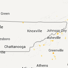
North Carolina
| Local Time | Report Details |
|---|---|
| 6:25 PM UTC | Large tree split and large limbs down on ledbett in jackson county NC, 47.2 miles NW of Greenville, SC |
| 6:35 PM UTC | Large limbs down along hw in avery county NC, 45.3 miles SSE of Bristol, TN |
| 6:45 PM UTC | Quarter sized hail reported near Sylva, NC, 48.7 miles NW of Greenville, SC, hail size of quarters currently falling at forestry office. |
| 7:25 PM UTC | Quarter sized hail reported near Robbinsville, NC, 49 miles S of Knoxville, TN, hail size of quarters off of harris creek rd on carpenter dr. nickel hail on franks creek rd. |
| 7:30 PM UTC | Several trees and large limbs down on bull creek road just south of hw in madison county NC, 56.9 miles SSW of Bristol, TN |
| 8:24 PM UTC | Tree and large limbs down near green mountain post office on hwy 197 west. mothball size hai in yancey county NC, 39 miles S of Bristol, TN |
| 8:48 PM UTC | Quarter sized hail reported near Morganton, NC, 59.8 miles WNW of Charlotte, NC, quarter sized hail fell at salem elementary school wednesday afternoon. |
| 8:48 PM UTC | Ping Pong Ball sized hail reported near Morganton, NC, 61.1 miles WNW of Charlotte, NC, at clyde valley airport...a report of hail up to the diameter of a silver dollar which we are estimating to be about ping pong ball sized. most of the hail was thin but |
| 9:04 PM UTC | Quarter sized hail reported near Candler, NC, 49.1 miles N of Greenville, SC |
| 9:04 PM UTC | Large tree limbs down in buncombe county NC, 51 miles N of Greenville, SC |
| 9:15 PM UTC | Quarter sized hail reported near Asheville, NC, 51 miles N of Greenville, SC |
Louisiana
| Local Time | Report Details |
|---|---|
| 6:40 PM UTC | Power lines were downed and nickel size hail. radar estimated tim in jefferson county LA, 5.2 miles WSW of New Orleans, LA |
| 9:00 PM UTC | 90 foot communications tower collapsed about 15 feet above base at ascension parish department of public works building. report received via web posting and confirmed b in ascension county LA, 53.7 miles WNW of New Orleans, LA |
| 9:55 PM UTC | Report from prairie larount. skirting blown off mobile hom in st. landry county LA, 17.9 miles N of Lafayette, LA |
Georgia
| Local Time | Report Details |
|---|---|
| 8:18 PM UTC | Numerous large limbs down and the top of a chimney blown off. this report was from the uncle of one of our spotter in habersham county GA, 48 miles W of Greenville, SC |
| 8:20 PM UTC | Trees down. also some small hail reports in demorest and cornelia that occurred up to around 5 pm but no specific hail size give in habersham county GA, 48.2 miles WSW of Greenville, SC |
| 9:13 PM UTC | Quarter sized hail reported near Baldwin, GA, 59 miles WSW of Greenville, SC, hail the size of quarters at the airport. damage to vehicles. |
New York
| Local Time | Report Details |
|---|---|
| 8:55 PM UTC | Quarter sized hail reported near Rotterdam, NY, 2.3 miles SSW of Schenectady, NY |
| 8:56 PM UTC | Trees and wires down in jefferson county NY, 32.4 miles SW of Ogdensburg, NY |
| 8:56 PM UTC | Trees and power lines down in jefferson county NY, 31.7 miles SW of Ogdensburg, NY |
| 9:00 PM UTC | Quarter sized hail reported near Schenectady, NY, 1.5 miles S of Schenectady, NY |
| 9:05 PM UTC | Quarter sized hail reported near Schenectady, NY, 1 miles SSE of Schenectady, NY |
| 9:13 PM UTC | Quarter sized hail reported near Niskayuna, NY, 4.6 miles SE of Schenectady, NY |
| 9:20 PM UTC | Trees and wires down in jefferson county NY, 60.7 miles SSW of Ogdensburg, NY |
| 9:20 PM UTC | Trees down throughout gouverneur in st. lawrence county NY, 24.4 miles S of Ogdensburg, NY |
| 9:20 PM UTC | Two birch trees knocked down in st. lawrence county NY, 28.6 miles S of Ogdensburg, NY |
| 9:25 PM UTC | Reports of numerous trees down in canton in st. lawrence county NY, 17 miles ESE of Ogdensburg, NY |
| 9:28 PM UTC | Trees and wires down in jefferson county NY, 54.5 miles SSW of Ogdensburg, NY |
| 9:30 PM UTC | Quarter sized hail reported near Holland Patent, NY, 46.7 miles ENE of Syracuse, NY |
| 9:38 PM UTC | Numerous reports of trees down in potsdam vicinity in st. lawrence county NY, 25.2 miles E of Ogdensburg, NY |
| 9:40 PM UTC | Trees and wires down in jefferson county NY, 49.6 miles S of Ogdensburg, NY |
| 9:40 PM UTC | Trees down in lewis county NY, 55 miles S of Ogdensburg, NY |
| 9:40 PM UTC | Trees down in lewis county NY, 42.5 miles S of Ogdensburg, NY |
| 9:40 PM UTC | Quarter sized hail reported near Barneveld, NY, 50.7 miles ENE of Syracuse, NY |
| 9:44 PM UTC | Quarter sized hail reported near Guilderland, NY, 8.2 miles SSE of Schenectady, NY |
| 9:45 PM UTC | Quarter sized hail reported near Albany, NY, 14.5 miles SE of Schenectady, NY |
| 9:45 PM UTC | Quarter sized hail reported near Albany, NY, 13.6 miles SE of Schenectady, NY |
| 9:45 PM UTC | Trees down in lewis county NY, 56.3 miles S of Ogdensburg, NY |
| 9:45 PM UTC | Trees down in lewis county NY, 59 miles S of Ogdensburg, NY |
| 9:48 PM UTC | Trees down in lewis county NY, 60.9 miles NNE of Syracuse, NY |
| 9:50 PM UTC | Trees down in lewis county NY, 61.7 miles NE of Syracuse, NY |
| 5:50 PM EDT | Quarter sized hail reported near Colonie, NY, 7.3 miles SE of Schenectady, NY |
| 9:50 PM UTC | Quarter sized hail reported near Albany, NY, 10.2 miles SSE of Schenectady, NY, nws office |
| 9:52 PM UTC | Quarter sized hail reported near Albany, NY, 13.3 miles SE of Schenectady, NY |
| 9:54 PM UTC | Quarter sized hail reported near Poland, NY, 56.4 miles ENE of Syracuse, NY |
| 9:54 PM UTC | Ping Pong Ball sized hail reported near Albany, NY, 13.9 miles SE of Schenectady, NY |
| 9:55 PM UTC | Quarter sized hail reported near Colonie, NY, 11.2 miles SE of Schenectady, NY |
| 9:59 PM UTC | Half Dollar sized hail reported near Barneveld, NY, 50.7 miles ENE of Syracuse, NY |
| 10:00 PM UTC | Quarter sized hail reported near North Greenbush, NY, 17.3 miles SE of Schenectady, NY |
| 10:01 PM UTC | Ping Pong Ball sized hail reported near Albany, NY, 14.2 miles SSE of Schenectady, NY |
| 10:01 PM UTC | Hen Egg sized hail reported near Poland, NY, 56.4 miles ENE of Syracuse, NY |
| 6:01 PM EDT | Golf Ball sized hail reported near Rensselaer, NY, 15.7 miles SE of Schenectady, NY |
| 10:06 PM UTC | Trees down along mcmaster road in franklin county NY, 50.9 miles E of Ogdensburg, NY |
| 10:08 PM UTC | Trees and wires down in herkimer county NY, 72.7 miles SSE of Ogdensburg, NY |
| 10:10 PM UTC | Quarter sized hail reported near Kirkland, NY, 38.9 miles E of Syracuse, NY |
| 10:11 PM UTC | Quarter sized hail reported near New Hartford, NY, 43.4 miles E of Syracuse, NY |
| 10:14 PM UTC | Ping Pong Ball sized hail reported near Litchfield, NY, 50.8 miles E of Syracuse, NY |
| 10:18 PM UTC | Trees down along jones pond road in franklin county NY, 48.3 miles W of Burlington, VT |
| 10:25 PM UTC | Trees dow in essex county NY, 32.2 miles WSW of Burlington, VT |
| 10:27 PM UTC | Quarter sized hail reported near Nassau, NY, 30.3 miles SE of Schenectady, NY |
| 10:30 PM UTC | Trees down along river road in essex county NY, 43.6 miles W of Burlington, VT |
| 10:30 PM UTC | Trees dow in essex county NY, 26.5 miles SW of Burlington, VT |
| 10:30 PM UTC | Trees and power lines in essex county NY, 59 miles SW of Burlington, VT |
| 10:31 PM UTC | Trees and wires down in hamilton county NY, 68.8 miles NNW of Schenectady, NY |
| 10:31 PM UTC | Trees and wires down in hamilton county NY, 66 miles NNW of Schenectady, NY |
| 10:31 PM UTC | Tree down in otsego county NY, 46.2 miles W of Schenectady, NY |
| 10:35 PM UTC | Quarter sized hail reported near Chatham, NY, 34.8 miles SE of Schenectady, NY |
| 10:35 PM UTC | Trees and wires down in hamilton county NY, 57.4 miles NNW of Schenectady, NY |
| 10:37 PM UTC | Wxnet6 in hamilton county NY, 43.6 miles NNW of Schenectady, NY |
| 10:40 PM UTC | Quarter sized hail reported near Canaan, NY, 38.1 miles SE of Schenectady, NY |
| 10:40 PM UTC | Quarter sized hail reported near Herkimer, NY, 55.3 miles WNW of Schenectady, NY |
| 10:44 PM UTC | Quarter sized hail reported near , , 56 miles WNW of Schenectady, NY |
| 10:45 PM UTC | Half Dollar sized hail reported near Canaan, NY, 35.9 miles SE of Schenectady, NY, hail broke windows |
| 10:45 PM UTC | Trees and wires down in warren county NY, 48.9 miles N of Schenectady, NY |
| 10:45 PM UTC | Tree down blocking route 20 in otsego county NY, 53.4 miles W of Schenectady, NY |
| 10:50 PM UTC | Trees and wires down in warren county NY, 60.6 miles N of Schenectady, NY |
| 10:56 PM UTC | Trees and wires down in montgomery county NY, 20.1 miles WNW of Schenectady, NY |
| 10:57 PM UTC | Trees and wires down in warren county NY, 58.3 miles N of Schenectady, NY |
| 11:00 PM UTC | Trees down in essex county NY, 37.9 miles SSW of Burlington, VT |
| 11:00 PM UTC | Trees down in essex county NY, 44.4 miles SSW of Burlington, VT |
| 11:00 PM UTC | Quarter sized hail reported near Canaan, NY, 38.1 miles SE of Schenectady, NY |
| 11:00 PM UTC | Ping Pong Ball sized hail reported near New Baltimore, NY, 27.2 miles SSE of Schenectady, NY |
| 11:05 PM UTC | Tea Cup sized hail reported near Coxsackie, NY, 31.9 miles SSE of Schenectady, NY |
| 11:08 PM UTC | Quarter sized hail reported near Fort Plain, NY, 35.9 miles WNW of Schenectady, NY |
| 11:32 PM UTC | Trees down power outages in albany county NY, 7.9 miles S of Schenectady, NY |
| 11:36 PM UTC | 2 large trees down in saratoga county NY, 19.6 miles NNE of Schenectady, NY |
| 11:40 PM UTC | Hen Egg sized hail reported near Saratoga Springs, NY, 19.8 miles NNE of Schenectady, NY, wind gusts estimated 50mph |
| 11:44 PM UTC | Trees and wires down in columbia county NY, 37.3 miles SSE of Schenectady, NY |
| 11:48 PM UTC | Trees and wires down on county route 7a in columbia county NY, 53.1 miles SSE of Schenectady, NY |
| 12:00 AM UTC | Quarter sized hail reported near Chatham, NY, 34.8 miles SE of Schenectady, NY |
| 12:00 AM UTC | Golf Ball sized hail reported near Cairo, NY, 35.2 miles S of Schenectady, NY |
| 8:00 PM EDT | Tea Cup sized hail reported near New Baltimore, NY, 26.2 miles SSE of Schenectady, NY |
| 12:20 AM UTC | Quarter sized hail reported near Catskill, NY, 41.7 miles S of Schenectady, NY, wxnet6 |
| 12:25 AM UTC | Quarter sized hail reported near Germantown, NY, 47.2 miles S of Schenectady, NY |
| 12:30 AM UTC | Half Dollar sized hail reported near Germantown, NY, 47.2 miles S of Schenectady, NY |
| 12:45 AM UTC | Quarter sized hail reported near Saugerties, NY, 51.2 miles S of Schenectady, NY, hail broke kitchen window |
| 12:45 AM UTC | Golf Ball sized hail reported near Tivoli, NY, 52 miles S of Schenectady, NY |
| 12:47 AM UTC | Quarter sized hail reported near Saugerties, NY, 51.2 miles S of Schenectady, NY |
| 12:49 AM UTC | Quarter sized hail reported near Saugerties, NY, 51.2 miles S of Schenectady, NY |
| 12:54 AM UTC | Quarter sized hail reported near Clermont, NY, 52.2 miles S of Schenectady, NY |
| 1:15 AM UTC | Trees down in jefferson county NY, 47.6 miles N of Syracuse, NY |
| 1:15 AM UTC | Trees down in jefferson county NY, 44.6 miles SSW of Ogdensburg, NY |
| 1:15 AM UTC | Trees down in jefferson county NY, 55.3 miles N of Syracuse, NY |
| 1:20 AM UTC | Trees down in jefferson county NY, 50.6 miles N of Syracuse, NY |
| 1:28 AM UTC | Trees and lines down in lewis county NY, 55.1 miles S of Ogdensburg, NY |
| 1:33 AM UTC | Trees and lines down in lewis county NY, 58.6 miles NE of Syracuse, NY |
| 1:35 AM UTC | Trees and lines down in lewis county NY, 56.3 miles S of Ogdensburg, NY |
| 1:36 AM UTC | Trees and lines down in lewis county NY, 55 miles S of Ogdensburg, NY |
| 1:36 AM UTC | Trees and lines down in lewis county NY, 60.9 miles NNE of Syracuse, NY |
| 1:43 AM UTC | Trees and lines down in lewis county NY, 61.7 miles NE of Syracuse, NY |
| 1:50 AM UTC | Trees and lines down in lewis county NY, 57.7 miles NE of Syracuse, NY |
| 1:55 AM UTC | Trees down in lewis county NY, 55.5 miles NE of Syracuse, NY |
| 2:25 AM UTC | Tree down in steube in oneida county NY, 47.6 miles ENE of Syracuse, NY |
| 2:40 AM UTC | Quarter sized hail reported near New Berlin, NY, 52.6 miles SE of Syracuse, NY |
| 2:45 AM UTC | Half Dollar sized hail reported near Morris, NY, 57.2 miles SE of Syracuse, NY |
| 3:00 AM UTC | Half Dollar sized hail reported near New Berlin, NY, 52.6 miles SE of Syracuse, NY |
| 3:05 AM UTC | Tree and wires down in otsego county NY, 51.6 miles WSW of Schenectady, NY |
| 3:10 AM UTC | Quarter sized hail reported near Oneonta, NY, 62.7 miles WSW of Schenectady, NY |
| 4:18 AM UTC | Tree limbs down on borgart r in greene county NY, 44.5 miles S of Schenectady, NY |
| 12:35 AM EDT | Baseball sized hail reported near Red Hook, NY, 56.2 miles S of Schenectady, NY |
| 5:00 AM UTC | Quarter sized hail reported near , , 61 miles S of Schenectady, NY |
| 5:00 AM UTC | Half Dollar sized hail reported near Marbletown, NY, 67.2 miles S of Schenectady, NY |
| 5:05 AM UTC | Half Dollar sized hail reported near Marbletown, NY, 67.2 miles S of Schenectady, NY |
| 5:09 AM UTC | Quarter sized hail reported near Rosendale, NY, 68.1 miles S of Schenectady, NY, winds estimated at 50 to 60 mph. |
| 5:10 AM UTC | Quarter sized hail reported near Rosendale, NY, 66.8 miles S of Schenectady, NY |
| 5:10 AM UTC | Golf Ball sized hail reported near Marbletown, NY, 67.2 miles S of Schenectady, NY |
| 5:10 AM UTC | Tree limbs down accompanied by nickel size hai in ulster county NY, 66.9 miles S of Schenectady, NY |
| 5:40 AM UTC | Quarter sized hail reported near Beekman, NY, 65.4 miles NNE of Brooklyn, NY |
Maine
| Local Time | Report Details |
|---|---|
| 9:54 PM UTC | Trees and powerlines down in soldier pon in aroostook county ME, 34 miles NW of Caribou, ME |
| 10:31 PM UTC | Trees and powerlines down in stockhol in aroostook county ME, 13.9 miles NNW of Caribou, ME |
| 10:32 PM UTC | Numerous trees uprooted in aroostook county ME, 10.2 miles WNW of Caribou, ME |
| 10:36 PM UTC | Several large trees uprooted in aroostook county ME, 8.3 miles WNW of Caribou, ME |
| 10:45 PM UTC | Numerous trees and power lines down across ashlan in aroostook county ME, 24.7 miles SW of Caribou, ME |
| 10:45 PM UTC | Numerous trees down in aroostook county ME, 8 miles NE of Caribou, ME |
| 10:45 PM UTC | Numeorous trees and powerlines down on albair roa in aroostook county ME, 6.1 miles NNE of Caribou, ME |
| 10:45 PM UTC | Numerous trees and powerlines down on albair roa in aroostook county ME, 6.1 miles NNE of Caribou, ME |
| 11:00 PM UTC | Numerous trees and powerlines down in ashlan in aroostook county ME, 24.7 miles SW of Caribou, ME |
| 11:00 PM UTC | Garage moved in to road on plante roa in aroostook county ME, 6 miles NNW of Caribou, ME |
| 11:00 PM UTC | Barn destroyed on brissette roa in aroostook county ME, 6.1 miles NNE of Caribou, ME |
| 11:15 PM UTC | Trees down on route 16 in aroostook county ME, 18.7 miles SW of Caribou, ME |
| 11:20 PM UTC | Numerous trees and powerlines down in ashlan in aroostook county ME, 24.7 miles SW of Caribou, ME |
| 11:20 PM UTC | Numerous trees down in caribo in aroostook county ME, 0.1 miles NE of Caribou, ME |
| 11:30 PM UTC | Trees down on bowls roa in aroostook county ME, 2.1 miles NE of Caribou, ME |
| 11:30 PM UTC | Numerous trees and powerlines down on madawaska roa in aroostook county ME, 6 miles NE of Caribou, ME |
| 11:49 PM UTC | Trees down in mapleto in aroostook county ME, 14.3 miles SSW of Caribou, ME |
| 11:49 PM UTC | Numerous trees dow in aroostook county ME, 16.9 miles SSW of Caribou, ME |
| 12:45 AM UTC | Trees down. pea size hai in somerset county ME, 91.3 miles NW of Bangor, ME |
South Carolina
| Local Time | Report Details |
|---|---|
| 10:00 PM UTC | Fire department reports several large limbs down and at least one power lin in pickens county SC, 1 miles SE of Greenville, SC |
| 6:05 PM EDT | Quarter sized hail reported near Easley, SC, 1 miles SE of Greenville, SC, quarter sized hail reported by the public. |
| 10:20 PM UTC | Tree on house at 106 holiday st in anderson county SC, 15.4 miles SSE of Greenville, SC |
| 10:24 PM UTC | Wind gust brought down numerous large limbs and power line in anderson county SC, 15.4 miles SSE of Greenville, SC |
| 10:25 PM UTC | Quarter sized hail reported near Pelzer, SC, 15.4 miles SSE of Greenville, SC, quarter sized hail. |
| 10:32 PM UTC | Tree down on highway 29 at anderson highway in anderson county SC, 15.7 miles SSE of Greenville, SC |
| 11:00 PM UTC | Tree down in anderson county SC, 21.6 miles S of Greenville, SC |
| 11:24 PM UTC | Quarter sized hail reported near Anderson, SC, 23 miles S of Greenville, SC, dime to quarter size hail on dun |
Iowa
| Local Time | Report Details |
|---|---|
| 10:27 PM UTC | Golf Ball sized hail reported near Reinbeck, IA, 52.9 miles WNW of Cedar Rapids, IA |
| 10:29 PM UTC | Quarter sized hail reported near Reinbeck, IA, 55.3 miles WNW of Cedar Rapids, IA |
| 10:34 PM UTC | Quarter sized hail reported near Gladbrook, IA, 54.1 miles WNW of Cedar Rapids, IA, dime to quarter size... |
| 10:40 PM UTC | Golf Ball sized hail reported near Reinbeck, IA, 48.4 miles WNW of Cedar Rapids, IA |
| 10:48 PM UTC | Quarter sized hail reported near Ankeny, IA, 10.4 miles N of Des Moines, IA |
| 10:56 PM UTC | Quarter sized hail reported near Jesup, IA, 40.3 miles NNW of Cedar Rapids, IA |
| 10:57 PM UTC | Half Dollar sized hail reported near Jesup, IA, 40.3 miles NNW of Cedar Rapids, IA, heavy rain also occurring. one half inch of rain in a half hour. some street flooding is occurring. |
| 11:06 PM UTC | Quarter sized hail reported near Gladbrook, IA, 55.3 miles WNW of Cedar Rapids, IA, dime to quarter size |
| 11:10 PM UTC | Quarter sized hail reported near Strawberry Point, IA, 49.1 miles N of Cedar Rapids, IA |
| 11:10 PM UTC | Golf Ball sized hail reported near Garnavillo, IA, 65.1 miles S of La Crosse, WI |
| 11:10 PM UTC | Golf Ball sized hail reported near Strawberry Point, IA, 53.4 miles N of Cedar Rapids, IA |
| 11:15 PM UTC | Quarter sized hail reported near Strawberry Point, IA, 49.1 miles N of Cedar Rapids, IA |
| 11:18 PM UTC | Ping Pong Ball sized hail reported near Traer, IA, 48.1 miles WNW of Cedar Rapids, IA |
| 11:23 PM UTC | Quarter sized hail reported near Collins, IA, 26.6 miles NE of Des Moines, IA |
| 11:25 PM UTC | Ping Pong Ball sized hail reported near Maxwell, IA, 24.9 miles NNE of Des Moines, IA |
| 11:30 PM UTC | Quarter sized hail reported near , , 28.5 miles NW of Cedar Rapids, IA |
| 11:33 PM UTC | Quarter sized hail reported near Collins, IA, 27.7 miles NNE of Des Moines, IA, trained spotter reported quarter sized hail at 690th and 295th northwest of collins. relayed by emergency manager. |
| 11:45 PM UTC | Quarter sized hail reported near Melbourne, IA, 36 miles NE of Des Moines, IA |
| 11:45 PM UTC | Ping Pong Ball sized hail reported near Traer, IA, 41.1 miles WNW of Cedar Rapids, IA |
| 11:53 PM UTC | Quarter sized hail reported near Ankeny, IA, 11.8 miles N of Des Moines, IA |
| 12:00 AM UTC | Ping Pong Ball sized hail reported near Mt Auburn, IA, 29 miles NW of Cedar Rapids, IA |
| 12:10 AM UTC | Quarter sized hail reported near Vinton, IA, 22.3 miles NW of Cedar Rapids, IA |
| 12:15 AM UTC | Quarter sized hail reported near Vinton, IA, 22.3 miles NW of Cedar Rapids, IA, approximate time. |
| 12:15 AM UTC | Ping Pong Ball sized hail reported near Vinton, IA, 23.5 miles NW of Cedar Rapids, IA, spotter network |
| 12:17 AM UTC | Golf Ball sized hail reported near Vinton, IA, 24 miles NW of Cedar Rapids, IA, several reports of golf ball sized hail. event continuing |
| 12:27 AM UTC | Ping Pong Ball sized hail reported near Urbana, IA, 19.9 miles NNW of Cedar Rapids, IA, most of hail was half inch with a few ping pong ball size |
| 12:28 AM UTC | Quarter sized hail reported near Baxter, IA, 29.2 miles NE of Des Moines, IA, an amateur radio operator reports up to quarter sized hail falling in baxter. |
| 12:30 AM UTC | 65-70 mph winds in benton county IA, 15.7 miles NW of Cedar Rapids, IA |
| 12:30 AM UTC | Quarter sized hail reported near Shellsburg, IA, 15.7 miles NW of Cedar Rapids, IA |
| 12:30 AM UTC | Half Dollar sized hail reported near Baxter, IA, 31.3 miles NE of Des Moines, IA |
| 12:33 AM UTC | Hen Egg sized hail reported near Baxter, IA, 31.3 miles NE of Des Moines, IA, largest stone measured 2.25 inches in diameter |
| 12:34 AM UTC | Quarter sized hail reported near Shellsburg, IA, 14.2 miles NW of Cedar Rapids, IA |
| 12:34 AM UTC | Wind gust of 70 to 80 mph. large branches in the middle of the stree in linn county IA, 4.4 miles N of Cedar Rapids, IA |
| 12:34 AM UTC | Large tree down blocking the road in linn county IA, 3.4 miles W of Cedar Rapids, IA |
| 12:35 AM UTC | Report of power outage on the northeast side of cedar rapid in linn county IA, 4.4 miles N of Cedar Rapids, IA |
| 12:35 AM UTC | Tennis Ball sized hail reported near Baxter, IA, 31.7 miles NE of Des Moines, IA |
| 12:45 AM UTC | Wind gust of 70 to 80 mph. large branches in the middle of the stree in linn county IA, 4.4 miles N of Cedar Rapids, IA |
| 12:48 AM UTC | Golf Ball sized hail reported near Laurel, IA, 39.5 miles ENE of Des Moines, IA, golf ball hail...time estimated from radar |
| 12:50 AM UTC | Storm damage reported in linn county IA, 6.1 miles NNE of Cedar Rapids, IA |
| 12:55 AM UTC | Half inch diameter branches down with picnic table blown ove in linn county IA, 5.9 miles NNE of Cedar Rapids, IA |
| 12:58 AM UTC | Golf Ball sized hail reported near Central City, IA, 17 miles NNE of Cedar Rapids, IA, radar estimated |
| 1:01 AM UTC | Delayed report. rwis data from june 8t in jones county IA, 18.4 miles ENE of Cedar Rapids, IA |
| 1:02 AM UTC | Roof damage to homes. shed destroyed. also reported dime sized hai in linn county IA, 5.9 miles NNE of Cedar Rapids, IA |
| 1:04 AM UTC | Quarter sized hail reported near Prairieburg, IA, 22.1 miles NE of Cedar Rapids, IA, spotter relayed a ham radio report |
| 1:05 AM UTC | Quarter sized hail reported near Central City, IA, 20.1 miles NE of Cedar Rapids, IA, most hail 1/4 to 1/2 inch with a few quarters. |
| 1:11 AM UTC | Iowa dot report in jones county IA, 22.3 miles ENE of Cedar Rapids, IA |
| 1:13 AM UTC | Numerous trees down in linn county IA, 12.3 miles NNE of Cedar Rapids, IA |
| 1:13 AM UTC | Numerous trees down in linn county IA, 7.2 miles N of Cedar Rapids, IA |
| 1:40 AM UTC | Storm damage reported in benton county IA, 9.6 miles W of Cedar Rapids, IA |
| 8:40 PM CDT | Storm damage reported in linn county IA, 7 miles NE of Cedar Rapids, IA |
| 1:40 AM UTC | Half Dollar sized hail reported near Cedar Rapids, IA, 1.4 miles W of Cedar Rapids, IA, quarter to half dollar |
| 8:41 PM CDT | Golf Ball sized hail reported near Cedar Rapids, IA, 4.9 miles NNE of Cedar Rapids, IA |
| 1:43 AM UTC | Hen Egg sized hail reported near Cedar Rapids, IA, 0.5 miles SSE of Cedar Rapids, IA |
| 8:45 PM CDT | Golf Ball sized hail reported near Cedar Rapids, IA, 1.3 miles ENE of Cedar Rapids, IA, quarter to golf ball |
| 8:50 PM CDT | Ping Pong Ball sized hail reported near Cedar Rapids, IA, 0.4 miles NW of Cedar Rapids, IA |
| 1:52 AM UTC | Quarter sized hail reported near Cedar Rapids, IA, 0.5 miles SSE of Cedar Rapids, IA |
| 1:52 AM UTC | Quarter sized hail reported near Cedar Rapids, IA, 1.5 miles NE of Cedar Rapids, IA |
| 1:53 AM UTC | Golf Ball sized hail reported near North English, IA, 37.8 miles SSW of Cedar Rapids, IA |
| 1:54 AM UTC | Quarter sized hail reported near North English, IA, 37.8 miles SSW of Cedar Rapids, IA |
| 8:55 PM CDT | 50 to 60 mph winds in linn county IA, 6.5 miles NE of Cedar Rapids, IA |
| 8:55 PM CDT | Quarter sized hail reported near Marion, IA, 7 miles NE of Cedar Rapids, IA, shredding leaves from the trees. also reports wind gusts of 50 to 60 mph. |
| 1:55 AM UTC | Quarter sized hail reported near Cedar Rapids, IA, 1.2 miles NE of Cedar Rapids, IA |
| 1:57 AM UTC | Quarter sized hail reported near Cedar Rapids, IA, 0.5 miles SSE of Cedar Rapids, IA, dimes to quarters. |
| 1:57 AM UTC | Quarter sized hail reported near Marion, IA, 7.7 miles NE of Cedar Rapids, IA, most hail was 3/4 inch |
| 1:57 AM UTC | Quarter sized hail reported near Cedar Rapids, IA, 3.3 miles E of Cedar Rapids, IA, penny to quarter sized hail. |
| 2:15 AM UTC | Quarter sized hail reported near Mt Vernon, IA, 13.6 miles ESE of Cedar Rapids, IA, hail covered the road |
| 2:20 AM UTC | Quarter sized hail reported near Parnell, IA, 29.3 miles SSW of Cedar Rapids, IA |
| 2:30 AM UTC | Quarter sized hail reported near Monmouth, IA, 41.5 miles E of Cedar Rapids, IA |
| 8:40 AM UTC | Quarter sized hail reported near Stanton, IA, 47.9 miles ESE of Omaha, NE, late report. from storms that moved through in the middle of the night. |
| 10:12 AM UTC | Wind gusts are estimated to be at least 60 mp in scott county IA, 60.8 miles SE of Cedar Rapids, IA |
| 10:22 AM UTC | Delayed report. rwis data from june 9t in scott county IA, 68.4 miles ESE of Cedar Rapids, IA |
| 10:25 AM UTC | Several 8 inch diameter branches down at 8th and state streets in bettendor in scott county IA, 68 miles ESE of Cedar Rapids, IA |
| 10:32 AM UTC | Delayed report. rwis data from june 9t in scott county IA, 68.4 miles ESE of Cedar Rapids, IA |
| 10:40 AM UTC | In a 3 block area in le claire many whole trees and large branches down...some on house in scott county IA, 72.7 miles ESE of Cedar Rapids, IA |
| 11:29 AM UTC | Storm damage reported in polk county IA, 0.7 miles SSW of Des Moines, IA |
Wyoming
| Local Time | Report Details |
|---|---|
| 10:34 PM UTC | Ping Pong Ball sized hail reported near Wheatland, WY, 50.6 miles NNE of Laramie, WY, mostly marble sized but a few large ones as well. |
| 10:58 PM UTC | Ping Pong Ball sized hail reported near Wheatland, WY, 60.5 miles NNE of Laramie, WY |
| 11:03 PM UTC | Quarter sized hail reported near Wheatland, WY, 62.9 miles NNE of Laramie, WY |
| 11:05 PM UTC | Golf Ball sized hail reported near Wheatland, WY, 60.5 miles NNE of Laramie, WY |
| 11:08 PM UTC | Golf Ball sized hail reported near Wheatland, WY, 64.1 miles NNE of Laramie, WY |
| 11:10 PM UTC | Quarter sized hail reported near Wheatland, WY, 58 miles WNW of Scottsbluff, NE |
| 11:55 PM UTC | Half Dollar sized hail reported near , , 47.2 miles WNW of Scottsbluff, NE |
| 12:16 AM UTC | Quarter sized hail reported near Veteran, WY, 40.5 miles WNW of Scottsbluff, NE, hail 2-3 inches deep in some spots. |
| 1:15 AM UTC | Quarter sized hail reported near Natrona, WY, 27.4 miles WNW of Casper, WY |
| 1:37 AM UTC | Half Dollar sized hail reported near Casper, WY, 7.5 miles WNW of Casper, WY, reported by tv meteorologist near the casper-natrona county international airport. |
| 1:45 AM UTC | Hen Egg sized hail reported near Casper, WY, 9 miles N of Casper, WY, trained spotter and off-duty nws meteorologist each reported 2 inch diameter hail near milepost 195 on interstate 25. |
| 4:00 AM UTC | Quarter sized hail reported near Newcastle, WY, 61 miles SSE of Gillette, WY, heavy rain accompanied hail last night. |
Virginia
| Local Time | Report Details |
|---|---|
| 10:45 PM UTC | Half Dollar sized hail reported near Dayton, VA, 54.4 miles SE of Elkins, WV |
| 10:54 PM UTC | Quarter sized hail reported near Head Waters, VA, 47.5 miles SSE of Elkins, WV |
| 11:45 PM UTC | Quarter sized hail reported near Singers Glen, VA, 55.5 miles ESE of Elkins, WV |
Massachusetts
| Local Time | Report Details |
|---|---|
| 10:50 PM UTC | Quarter sized hail reported near West Stockbridge, MA, 43.2 miles SE of Schenectady, NY |
| 10:56 PM UTC | Golf Ball sized hail reported near Stockbridge, MA, 48 miles SE of Schenectady, NY |
| 12:00 AM UTC | Golf Ball sized hail reported near Pittsfield, MA, 42.8 miles SE of Schenectady, NY |
| 12:05 AM UTC | Quarter sized hail reported near Pittsfield, MA, 42.8 miles SE of Schenectady, NY |
| 12:10 AM UTC | Ping Pong Ball sized hail reported near Pittsfield, MA, 42.8 miles SE of Schenectady, NY |
| 12:20 AM UTC | Numerous trees and limbs down in berkshire county MA, 48 miles SE of Schenectady, NY |
| 12:24 AM UTC | *** 1 inj *** trees down in berkshire county MA, 45.6 miles SE of Schenectady, NY |
| 12:29 AM UTC | Several trees down up to 8 inches in diameter on west street in hampshire county MA, 58.2 miles ESE of Schenectady, NY |
| 12:30 AM UTC | Several trees down off route 143 on a dirt road in hampshire county MA, 62.5 miles ESE of Schenectady, NY |
| 12:52 AM UTC | Large tree down on granville road in hampden county MA, 72.8 miles WNW of Providence, RI |
| 1:43 AM UTC | Trees and wires down on stafford street in worcester county MA, 35.7 miles NW of Providence, RI |
| 1:49 AM UTC | Trees down on west main street in worcester county MA, 30.9 miles WNW of Providence, RI |
| 1:49 AM UTC | Trees and wires down on brown road and joe jenny road near sutton avenue in worcester county MA, 31.2 miles NW of Providence, RI |
| 1:50 AM UTC | Trees down on route 131 in worcester county MA, 30.9 miles WNW of Providence, RI |
| 1:51 AM UTC | Large branches and wires down on central street in worcester county MA, 33.7 miles NW of Providence, RI |
| 2:00 AM UTC | Trees down on glendale avenue in worcester county MA, 20.2 miles NNW of Providence, RI |
| 2:04 AM UTC | Tree down blocking roadway in worcester county MA, 16.7 miles NNW of Providence, RI |
| 2:55 AM UTC | Large branch down on marilyn street and wires down on mill road in bristol county MA, 26.9 miles ESE of Providence, RI |
| 4:35 AM UTC | Quarter sized hail reported near Becket, MA, 55.1 miles SE of Schenectady, NY |
| 5:02 AM UTC | Trees and wires down along south lane in hampden county MA, 75 miles SE of Schenectady, NY |
| 5:02 AM UTC | Tree down blocking a road in northampton ... street unknow in hampshire county MA, 72.4 miles ESE of Schenectady, NY |
| 5:14 AM UTC | Golf Ball sized hail reported near Hampden, MA, 54.6 miles WNW of Providence, RI, lots of quarter size hail mixed in with a few larger stones up to golf ball |
| 6:25 AM UTC | Tree down in area of madison street blocking the roadway in bristol county MA, 17.5 miles ESE of Providence, RI |
Vermont
| Local Time | Report Details |
|---|---|
| 11:38 PM UTC | Multiple trees down on state street in rutland county VT, 60.8 miles S of Burlington, VT |
| 11:40 PM UTC | Few trees down along route 7 near route 103...winds estimated at 70 mp in rutland county VT, 65.2 miles S of Burlington, VT |
| 11:40 PM UTC | Few trees down as well as powerlines along route 7 near route 103 and rutland state airport...winds estimated at 70 mp in rutland county VT, 65.2 miles S of Burlington, VT |
| 11:42 PM UTC | Few trees down as well as powerlines along route 7 near route 103 and rutland state airport...winds estimated at 70 mp in rutland county VT, 65.2 miles S of Burlington, VT |
| 11:45 PM UTC | Trees and powerlines down along corn hill rd in rutland county VT, 53.7 miles S of Burlington, VT |
| 11:45 PM UTC | Trees down along route 100 in rochester in windsor county VT, 46.4 miles SSE of Burlington, VT |
| 12:05 AM UTC | Trees down along route 106 in woodstock in windsor county VT, 67.8 miles SSE of Burlington, VT |
| 12:25 AM UTC | Trees down in windham county VT, 71.8 miles ENE of Schenectady, NY |
| 12:25 AM UTC | Trees down in windham county VT, 64.1 miles ENE of Schenectady, NY |
| 12:39 AM UTC | Trees and powerlines down in essex county VT, 89.9 miles ENE of Burlington, VT |
| 12:45 AM UTC | Trees and powerlines down along corn hill rd in rutland county VT, 53.7 miles S of Burlington, VT |
Connecticut
| Local Time | Report Details |
|---|---|
| 12:10 AM UTC | Golf Ball sized hail reported near North Canaan, CT, 62.4 miles SSE of Schenectady, NY |
| 1:03 AM UTC | Quarter sized hail reported near Canaan, CT, 66.5 miles SSE of Schenectady, NY |
| 1:14 AM UTC | Quarter sized hail reported near Sharon, CT, 68.7 miles SSE of Schenectady, NY |
| 1:45 AM UTC | Quarter sized hail reported near Kent, CT, 76.6 miles SSE of Schenectady, NY |
| 2:00 AM UTC | Two trees down on randolph road. time esitmate in middlesex county CT, 66.8 miles WSW of Providence, RI |
| 5:40 AM UTC | Trees and wires down along harrisville roa in windham county CT, 30.6 miles WNW of Providence, RI |
New Hampshire
| Local Time | Report Details |
|---|---|
| 12:20 AM UTC | Tree down on house. lightning hit another tree and started a fir in sullivan county NH, 87.1 miles SSE of Burlington, VT |
Colorado
| Local Time | Report Details |
|---|---|
| 12:32 AM UTC | Quarter sized hail reported near Strasburg, CO, 36.8 miles ENE of Denver, CO, soft hail |
| 1:32 AM UTC | Half Dollar sized hail reported near Fort Morgan, CO, 61.7 miles ENE of Denver, CO |
| 1:52 AM UTC | Quarter sized hail reported near Fort Morgan, CO, 56.5 miles W of Yuma, CO |
| 2:50 AM UTC | Ping Pong Ball sized hail reported near Kersey, CO, 53 miles NNE of Denver, CO |
| 3:22 AM UTC | Half Dollar sized hail reported near Windsor, CO, 50.5 miles N of Denver, CO |
| 3:30 AM UTC | Quarter sized hail reported near Windsor, CO, 51.9 miles N of Denver, CO |
| 3:45 AM UTC | Three power poles and fences down in western greeley in weld county CO, 47.3 miles N of Denver, CO |
| 4:40 AM UTC | Quarter sized hail reported near Timnath, CO, 53.8 miles N of Denver, CO |
| 4:48 AM UTC | Quarter sized hail reported near Fort Collins, CO, 54.6 miles N of Denver, CO |
| 5:00 AM UTC | Quarter sized hail reported near Westminster, CO, 11.5 miles NNW of Denver, CO |
| 5:22 AM UTC | Golf Ball sized hail reported near Fort Collins, CO, 53.6 miles N of Denver, CO |
| 7:30 AM UTC | 4.5 inch diameter tree limbs down. 1.75 inches rain. no hai in weld county CO, 64.3 miles NNE of Denver, CO |
Oklahoma
| Local Time | Report Details |
|---|---|
| 12:40 AM UTC | Storm damage reported in harmon county OK, 28.2 miles NE of Childress, TX |
| 12:51 AM UTC | Storm damage reported in greer county OK, 58.5 miles NE of Childress, TX |
| 12:51 AM UTC | Golf Ball sized hail reported near Buffalo, OK, 25.4 miles N of Woodward, OK |
| 2:10 AM UTC | Golf Ball sized hail reported near Freedom, OK, 28.4 miles N of Woodward, OK |
| 2:38 AM UTC | Storm damage reported in jackson county OK, 53.8 miles E of Childress, TX |
| 2:48 AM UTC | 35 foot tall tree with a two foot diameter trunk was blown over by high winds onto a tipton police car. the police car was facing west with its radar gun le in tillman county OK, 54.8 miles NW of Wichita Falls, TX |
Kansas
| Local Time | Report Details |
|---|---|
| 12:55 AM UTC | Golf Ball sized hail reported near Lake City, KS, 62.6 miles NNE of Woodward, OK |
| 1:00 AM UTC | Quarter sized hail reported near Medicine Lodge, KS, 75 miles WSW of Wichita, KS |
| 1:15 AM UTC | Quarter sized hail reported near Sawyer, KS, 69.6 miles W of Wichita, KS |
| 1:30 AM UTC | Walnut tree blown over. time estimate in dickinson county KS, 40.6 miles SSW of Manhattan, KS |
| 1:35 AM UTC | Storm damage reported in barber county KS, 67.2 miles NE of Woodward, OK |
| 1:36 AM UTC | Quarter sized hail reported near Cunningham, KS, 60.1 miles W of Wichita, KS |
| 1:47 AM UTC | Ping Pong Ball sized hail reported near Cunningham, KS, 53 miles W of Wichita, KS |
| 3:00 AM UTC | A couple of two-foot diameter trees were uproote in barber county KS, 58.8 miles NE of Woodward, OK |
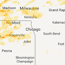
Illinois
| Local Time | Report Details |
|---|---|
| 1:37 AM UTC | Small limbs and leaves down in winnebago county IL, 45.9 miles SSE of Madison, WI |
| 1:37 AM UTC | 5 inch branch dow in winnebago county IL, 44.8 miles SSE of Madison, WI |
| 1:45 AM UTC | A few shingles blown of house. 6 foot ash in boone county IL, 56.4 miles SSE of Madison, WI |
| 2:24 AM UTC | Route 12 and winnebago road just west of intersection 20 to 30 year old tree snapped. trunk diameter estimated at 1 foo in mchenry county IL, 49.5 miles NW of Chicago, IL |
| 2:25 AM UTC | Large maple tree down with furniture blown around in the yard of hous in jo daviess county IL, 72.5 miles SW of Madison, WI |
| 2:27 AM UTC | Numerous treesdown in jo daviess county IL, 72.2 miles SW of Madison, WI |
| 2:31 AM UTC | Storm damage reported in stephenson county IL, 51.5 miles SSW of Madison, WI |
| 2:32 AM UTC | Storm damage reported in stephenson county IL, 52.9 miles SSW of Madison, WI |
| 2:32 AM UTC | Lots of small tree branches and some larger branches down around town...time estimated from rada in stephenson county IL, 52.9 miles SSW of Madison, WI |
| 2:32 AM UTC | Quarter sized hail reported near Orangeville, IL, 43.6 miles SSW of Madison, WI |
| 2:53 AM UTC | 15 ft long- 3in dia branch dow in lake county IL, 29.8 miles NW of Chicago, IL |
| 2:54 AM UTC | Power lines down on hwy 75 near town...relayed by media in stephenson county IL, 46 miles S of Madison, WI |
| 3:03 AM UTC | Golf Ball sized hail reported near Winnebago, IL, 55.9 miles S of Madison, WI, at wrex-tv studios. |
| 3:04 AM UTC | Power lines and trees down. report relayed from ogle county sheriff. time estimated from rada in ogle county IL, 65.8 miles S of Madison, WI |
| 3:04 AM UTC | Trees and power lines dow in ogle county IL, 65.8 miles S of Madison, WI |
| 3:10 AM UTC | Storm damage reported in boone county IL, 56.4 miles SSE of Madison, WI |
| 3:10 AM UTC | A few shingles blown of house. 6 foot ash in boone county IL, 56.4 miles SSE of Madison, WI |
| 3:11 AM UTC | Storm damage reported in winnebago county IL, 62 miles SSE of Madison, WI |
| 3:12 AM UTC | Quarter sized hail reported near Poplar Grove, IL, 56.4 miles SSE of Madison, WI, 3/4 to 1 inch hail. |
| 3:16 AM UTC | Power lines and trees dow in ogle county IL, 65.4 miles S of Madison, WI |
| 3:16 AM UTC | Power lines and trees down. report relayed from ogle county sheriff. time estimated from rada in ogle county IL, 65.4 miles S of Madison, WI |
| 3:22 AM UTC | Golf Ball sized hail reported near Belvidere, IL, 63 miles SSE of Madison, WI, south of belvidere - marble to golf ball sized hail. via broadcast media. |
| 3:22 AM UTC | Golf Ball sized hail reported near Belvidere, IL, 65.5 miles SSE of Madison, WI, estimated hail from marble to golfball in size. spotter was south of belvidere. winds estimated to 45 mph. |
| 3:29 AM UTC | Quarter sized hail reported near Polo, IL, 76.1 miles S of Madison, WI |
| 3:33 AM UTC | Tree limb on car. time estimated based on rada in kendall county IL, 48.9 miles WSW of Chicago, IL |
| 3:42 AM UTC | 6 in dia tree snapped. 7800 block of hildred r in winnebago county IL, 52.3 miles SSE of Madison, WI |
| 3:50 AM UTC | 6 in dia tree snapped. alpine rd and harriso in winnebago county IL, 57.9 miles SSE of Madison, WI |
| 3:51 AM UTC | 10 inch dia tree down. wilson waterview. possible lightning damag in winnebago county IL, 52.3 miles SSE of Madison, WI |
| 4:50 AM UTC | Telephone pole snapped. near fox river d in kendall county IL, 48.9 miles WSW of Chicago, IL |
| 4:53 AM UTC | Large trees down - il47 and baseline r in kane county IL, 44 miles WSW of Chicago, IL |
| 5:10 AM UTC | Tree down near us52 and lisbon r in kendall county IL, 52 miles WSW of Chicago, IL |
| 7:24 AM UTC | Quarter sized hail reported near Tampico, IL, 66.9 miles N of Peoria, IL |
| 8:00 AM UTC | Sustained winds 48-50 mph with peak gust to 58 mph. pea sized hail. 91st and clifton par in cook county IL, 11.9 miles SSW of Chicago, IL |
| 8:00 AM UTC | 5 inch dia tree fell on home with smaller branches down elswhere. 117th st and ridgelan in cook county IL, 15.7 miles SSW of Chicago, IL |
| 8:10 AM UTC | Storm damage reported in cook county IL, 17.5 miles SSE of Chicago, IL |
| 10:20 AM UTC | Wind gusts estimated to be 60 to 70 mph near the rock island arsenal bridge in molin in rock island county IL, 69.8 miles ESE of Cedar Rapids, IA |
| 10:22 AM UTC | Delayed report. rwis data from june 9t in rock island county IL, 67.9 miles ESE of Cedar Rapids, IA |
| 10:25 AM UTC | Measured at the quad city international airpor in rock island county IL, 70.7 miles ESE of Cedar Rapids, IA |
| 10:25 AM UTC | Measured at the quad city international airpor in rock island county IL, 69.8 miles ESE of Cedar Rapids, IA |
| 10:26 AM UTC | Storm damage reported in rock island county IL, 69.8 miles ESE of Cedar Rapids, IA |
| 10:26 AM UTC | Huge tree branches dow in rock island county IL, 69.8 miles ESE of Cedar Rapids, IA |
| 10:32 AM UTC | Delayed report. rwis data from june 9t in rock island county IL, 67.9 miles ESE of Cedar Rapids, IA |
| 10:34 AM UTC | Storm damage reported in rock island county IL, 72.5 miles NNW of Peoria, IL |
| 10:54 AM UTC | Half Dollar sized hail reported near Tampico, IL, 65.6 miles N of Peoria, IL, quarter to half dollar size hail. |
| 11:00 AM UTC | 7 to 8 inch diameter trees down. time estimated based on radar dat in henry county IL, 41.8 miles NNW of Peoria, IL |
Rhode Island
| Local Time | Report Details |
|---|---|
| 2:10 AM UTC | Tree down on highland street in providence county RI, 13 miles NNW of Providence, RI |
| 6:05 AM UTC | Quarter sized hail reported near West Greenwich, RI, 18.2 miles SW of Providence, RI |
| 6:14 AM UTC | Large branches down on south road in kent county RI, 18.2 miles SW of Providence, RI |
| 6:15 AM UTC | Large branches down across a roadway within the tow in providence county RI, 5.1 miles SW of Providence, RI |
| 6:15 AM UTC | Numerous wires and trees down ... including one on route 10 south and on maplewood in providence county RI, 5.1 miles SW of Providence, RI |
| 6:15 AM UTC | Several 4 to 6 inch diameter trees blown down along with a utility pole across roads in proximity to vetrans memorial parkway in providence county RI, 3.2 miles ESE of Providence, RI |
| 6:15 AM UTC | Tree down on wampanog trail in providence county RI, 3.2 miles ESE of Providence, RI |
| 6:15 AM UTC | Downed trees ... utility poles ... utility lines ... with utility poles and wires upon buildings in the vicinity of the north providence and providence border in providence county RI, 3.5 miles NW of Providence, RI |
| 6:15 AM UTC | Golf Ball sized hail reported near East Providence, RI, 3.2 miles ESE of Providence, RI |
Nebraska
| Local Time | Report Details |
|---|---|
| 6:01 AM UTC | Quarter sized hail reported near Palmyra, NE, 44.7 miles SSW of Omaha, NE |
| 6:03 AM UTC | Quarter sized hail reported near Bennet, NE, 49.9 miles SW of Omaha, NE, hail lasted about 10 minutes. |
| 6:35 AM UTC | Quarter sized hail reported near Lincoln, NE, 51.4 miles SW of Omaha, NE, near 27th and highway 2. |
| 6:35 AM UTC | Golf Ball sized hail reported near Lincoln, NE, 48.2 miles SW of Omaha, NE, near 84th and van dorn. |
Connect with Interactive Hail Maps